Tracking and Communicating Site Progress with Drones. Construction Webinar Series
|
|
|
- Clare Hamilton
- 5 years ago
- Views:
Transcription


1 Tracking and Communicating Site Progress with Drones Construction Webinar Series

2 We re Recording You will be provided with access to the recording and slides via shortly after the live session


3 Submit Your Questions We ll have a live Q+A session at the end of the webinar Submit your questions using the GoToWebinar Control Panel

4 Today s Agenda Introduction to Drones in Construction A Look at the DroneDeploy Platform Tracking Site Progress with Drones Introducing Progress Photos How Chasco Constructors Uses Drones Getting Started with Drones on Your Job Site Live Q+A Session


5 Meet Our Panelists Michael Lambert VDC Manager Chasco Constructors Andy Putch Product Manager DroneDeploy
6 Poll How do you currently track project progress?
7 Drones in Construction

8 Drones are Transforming Workflows Capture aerial imagery in minutes Share collaborative maps, models, and reports Survey sites in record time Integrate aerial data with everyday tools


9 Photos, Maps, Models, & More Photos Orthomosaic Maps 3D Models CAD Overlays
10 Value at Every Stage of a Project s Lifecycle Bid Process Preconstruction Design Construction Operations & Maintenance Renovation & Repair

11 Delivering ROI in Construction

12 Poll When do you plan to use drones on your job site?
13 Meet DroneDeploy


14 DroneDeploy The Leading Cloudbased Software Platform for Commercial Drones


15 An End-to-End Drone Data Solution Plan + Fly Process Analyze

16 Best-in-Class Commercial Drone Solution


17 Trusted by Industry Leaders
18 Tracking & Communicating Progress with Drones


19 Projects are Late and Over Budget More than half of construction projects finish late and over budget* Even when lean construction practices are applied Drones can help keep your project on track while saving time and resources *Data provided by Dodge Data & Analytics and McKinsey & Company

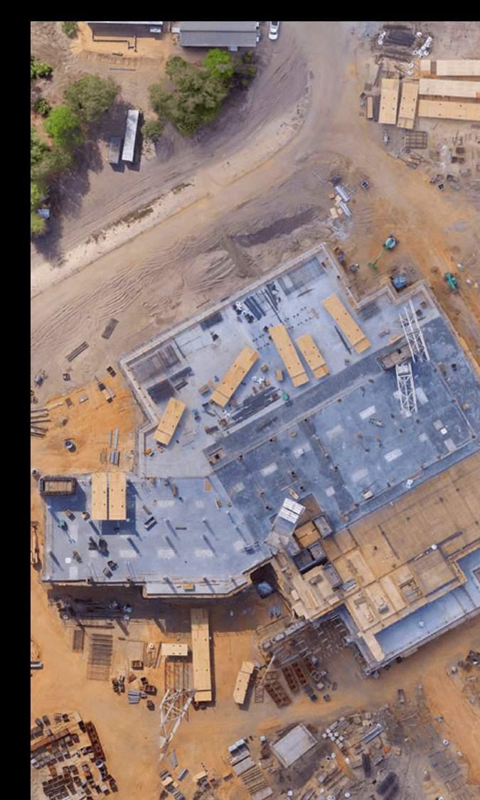
20 Tracking Site Progress with Drones Collect aerial imagery each week Create visual timelines Compare designs to site conditions Detect deviations from plans

21 Overlay Designs to Track Progress

22 Communicating Site Progress Keep stakeholders and clients up to date on a project s status Share collaborative maps and models with your team for better project management Connect the job site to the back office

23 Why Drone Imagery? Fast, same day turn around time Repeatable, consistent, and accurate data Low initial costs to prove value High return-on-investment (ROI) Easy to share, collaborate, and export data to your existing industry tools
24 Introducing Progress Photos


25 Progress Photos Solution Overview The only tool that automates construction project progress reporting Gather consistent and precise images of your project in minutes Generate progress reports Create a visual timeline of your project from start to finish


26 Progress Tracking Simplified Your entire workflow photos, maps, & models managed from a single app Repeatable and consistent imagery every time Customizable reports generated in minutes

27 The Workflow

28 Plan a Flight

29 Capture Photos

30 Upload Photos Wirelessly

31 Generate a Progress Photo Report
32 Chasco Constructors
33 Chasco Constructors Formed in 1979, Chasco Constructors is a progressive commercial general contracting and construction management firm committed to delivering the highest level of quality and services to our clients.

34 Chasco s Drone Program Launched in 2017, led by Michael. Currently using drones on 17 job sites Drone data is used by by the BIM/VDC team, as well as site superintendents and project managers.
35 Workflow Plan & Fly Process Analyze & Share Planning flights and capturing site imagery weekly with DroneDeploy Processing and storing maps, 3D models, and progress reports in the DroneDeploy Cloud Using measurement tools, annotations, and reporting features to: Track + report progress Measure stockpile Volume Track earthwork Collaborate with team Exporting data to tools including AutoCAD, PlanGrid and BlueBeam

36 Top Benefits of Using Drones at Chasco Fast data collection Accurate measurements and maps with GCPs Quick, precise stockpile volume calculation Easy to report progress over time from a single tool


37 Case Study: City of Round Rock, TX Municipal Client required weekly project updates to report progress to city officials and the public. Logistics Production Rates

38 Getting Started


39 New Construction Accuracy Package Customers enjoy access to the same tools, capabilities, and support available to Business plan, plus: Up to 3 Seats Unlimited GCP Maps Unlimited DTMs Learn More at

40 Where to Learn More New ebook available: Drones for Construction Project Management Check out our blog to read more tips and customer stories Explore our resource page for webinars, ebooks, and more More Resources at


41 Thank You