Executive Summary Conditional Use Authorization
|
|
|
- Darlene Merritt
- 5 years ago
- Views:
Transcription
1 Executive Summary Conditional Use Authorization HEARING DATE: MARCH 26, 2015 Date: March 19, 2015 Case No.: CV Project Address: Folsom Street Zoning: Folsom St NCT (Neighborhood Commercial Transit) Zoning District Western SOMA Special Use District 65 X Height and Bulk District Block/Lot: 3730/023 and 024 Project Sponsor: Erik Liu, Transworld Construction 1178 Folsom Street San Francisco, CA Staff Contact: Richard Sucré (415) richard.sucre@sfgov.org Recommendation: Approval with Conditions PROJECT DESCRIPTION The proposed project includes demolition of the two existing industrial buildings (approximately 9,600 gsf) and the new construction of a six story, 65 ft tall, mixed use building (approximately 42,675 gsf) with two ground floor commercial spaces (collectively measuring approximately 3,980 gsf), a second floor office space (approximately 5,908 gsf), and 42 single room occupancy (SRO) units on the third, fourth, fifth and sixth floors. Each of the SRO units are between 290 and 350 square feet in size. The project includes private useable open space for six units and 1,658 square feet of open space via an inner court on the third floor and a common roof deck on the sixth floor for the remaining units. The proposed project also includes 48 Class 1 bicycle parking spaces, 6 Class 2 bicycle parking spaces, and nine off street parking spaces located within a below grade garage accessible off of Clementina Street. SITE DESCRIPTION AND PRESENT USE The proposed project is located on two rectangular through lots (with a collective lot area of 4,000± square feet) on the west side of Folsom Street between 8 th and Rausch Streets with approximately 50 ft of frontage along Folsom Street and 50 ft of frontage along Clementina Street. Currently, the subject lot contains a one story warehouse and a two story warehouse/office. SURROUNDING PROPERTIES AND NEIGHBORHOOD The project site is located within the Folsom St NCT Zoning District in the Western SoMa Area Plan. The immediate context is mixed in character with a mix of residential, commercial and industrial development. The immediate neighborhood includes one to two story commercial properties, one tothree story industrial buildings, and four to five story residential complexes. Along Folsom Street adjacent to the project site are a five story residential complex with a ground floor commercial space and
2 Executive Summary Hearing Date: March 26, 2015 CASE NO CV a two story industrial building. Along Clementina Street, the immediate neighborhood includes smallerscale commercial and industrial properties, a three story residential building, and a larger scale residential building at the end of Clementina Street. The project site has two street frontages: Folsom Street, which is identified as a one way transit thoroughfare with a bike lane on the south side; and, Clementina Street, which is a smaller scale two way alleyway. Other zoning districts in the vicinity of the project site include: WMUG (Western SoMa Mixed Use General); P (Public); SoMa NCT (South of Market Neighborhood Commercial Transit); and, MUG (Mixed Use General). ENVIRONMENTAL REVIEW Pursuant to the Guidelines of the State Secretary of Resources for the implementation of the California Environmental Quality Act (CEQA), on March 12, 2015, the Planning Department of the City and County of San Francisco determined that the proposed application was exempt from further environmental review under Section of the CEQA Guidelines and California Public Resources Code Section The Project is consistent with the adopted zoning controls in the Eastern Neighborhoods Area Plan and was encompassed within the analysis contained in the Eastern Neighborhoods Area Plan Final EIR. Since the Final EIR was finalized, there have been no substantial changes to the Eastern Neighborhoods Area Plan and no substantial changes in circumstances that would require major revisions to the Final EIR due to the involvement of new significant environmental effects or an increase in the severity of previously identified significant impacts, and there is no new information of substantial importance that would change the conclusions set forth in the Final EIR. HEARING NOTIFICATION TYPE REQUIRED PERIOD REQUIRED NOTICE DATE ACTUAL NOTICE DATE ACTUAL PERIOD Classified News Ad 20 days March 6, 2015 March 6, days Posted Notice 20 days March 6, 2015 March 6, days Mailed Notice 20 days March 6, 2015 March 6, days The proposal requires a Section 312 Neighborhood notification, which was conducted in conjunction with the Conditional Use Authorization notice. PUBLIC COMMENT As of March 19, 2015, the Department has received public correspondences, which have expressed support and/or concern about the proposed project. Copies of this correspondence have been included in the Commissioner packets. ISSUES AND OTHER CONSIDERATIONS Conditional Use Authorization: The proposed project requires Conditional Use Authorization from the Planning Commission to establish a non residential use larger than 4,000 square feet within the Folsom St NCT Zoning District. Currently, the Project would establish an office use measuring approximately 5,908 square feet on the second floor. As defined in Planning Code 2
3 Executive Summary Hearing Date: March 26, 2015 CASE NO CV Section , office use is principally permitted on either the first or second floors, but not on both floors within the Folsom St NCT. Variances: The proposed project requires a Variance from the Zoning Administrator to address the Planning Code requirements for open space (Planning Code Section 135) and dwelling unit exposure (Planning Code Section 140). These variances are associated with the construction of the 42 SRO units on the third through sixth floors. Office Use: Within the Folsom St NCT Zoning District, office use is limited in its definition to the uses identified in Planning Code Section , which states that office use is a service defined in Planning Code Sections through Among the relevant categorizations, office use may be defined as: Administrative Service (Planning Code Section ), Philanthropic Administrative Service (Planning Code Section ), Business or Professional Service (Planning Code Section ), Financial Service (Planning Code Section ), Fringe Financial Service (Planning Code Section ), Limited Financial Service (Planning Code Section ), Medical Service (Planning Code Section ), and Personal Service (Planning Code Section ). Entrance to Off Street Parking: The Department reviewed the location of the curb cut for the proposed off street parking garage and supports its location on Clementina Street, rather than Folsom Street. The Western SoMa Area Plan and Draft Design Guidelines strongly encourage that curb cuts and driveways not be placed on residential alleys when there is an alternative. However, the Plan and Draft Design Guidelines also strongly encourage that Folsom Street be protected from conflicts with pedestrians, bicyclists, and transit as part of a long range planning effort to establish Folsom Street as the Main Street of SoMa. The Department s support for the proposed garage entrance location is based on several factors. The proposed garage entrance and curb cut will be located at the northern end of the project site. Further, the proposed garage is setback from the lot line, while the proposed curb cut will only be 10 feet wide. The design of the garage entrance and the curb cut reduces potential conflicts with other street and sidewalk users by requiring slow entry and exit speeds for vehicles. The proposed below grade garage accommodates only nine off street parking spaces, which is significantly lower than the maximum permitted amount of off street parking. Finally, the Western SoMa Area Plan identifies Folsom Street as a Transit Preferential Street. Planning Code Section 155(r)(4) recommends no curb cuts on Transit Preferential Streets, when an alternate frontage is available. Since the Project has frontage onto both Folsom and Clementina Streets, the Department supports the location to the off street parking along Clementina Street. Development Impact Fees: The Project would be subject to the following development impact fees, which are estimated as follows: FEE TYPE Transit Impact Development Fee (3,980 sq ft Change in Use from PDR to Retail) Transit Impact Development Fee (5,908 sq ft Change in Use from PDR to Office) Eastern Neighborhoods Impact Fee (9,600 sq ft Tier 2; Change in Use PDR to Non PLANNING CODE SECTION/FEE AMOUNT 411 (@ $5.69) $22, (@ $7.37) $43, (@ $8.50) $81,600 3
4 Executive Summary Hearing Date: March 26, 2015 FEE TYPE Residential) Eastern Neighborhoods Impact Fee (288 sq ft Tier 2; New Non Residential) Eastern Neighborhoods Impact Fee (26,916 sq ft Tier 2; New Residential) PLANNING CODE SECTION/FEE CASE NO CV AMOUNT 423 $12.14) $3, $14.56) $391,897 TOTAL $543,180 The Project Sponsor has filed an in kind agreement application, as an alternative to payment of Eastern Neighborhoods Impact Fee. Please note that these fees are subject to change between Planning Commission approval and approval of the associated Building Permit Application, as based upon the annual updates managed by the Development Impact Fee Unit of the Department of Building Inspection. REQUIRED COMMISSION ACTION In order for the project to proceed, the Commission must grant Conditional Use Authorization to allow a non residential use larger than 4,000 sq. ft in the Folsom St NCT (Neighborhood Commercial Transit) Zoning District, per Planning Code Sections 121.2, 303, and BASIS FOR RECOMMENDATION The Project complies with the applicable requirements of the Planning Code. The Project is consistent with the objectives and policies of the General Plan. The Project is located in zoning districts where retail, office and SRO units are principally permitted. The Project produces a new mixed use development with ground floor retail, second story office use and significant site updates, including landscaping, site furnishings, and private and common open space. The Project is consistent with and respects the varied neighborhood character, and provides an appropriate massing and scale for the adjacent contexts. The Project would establish a new office use, which requires a use size larger than the principally permitted limits. The Project complies with the First Source Hiring Program. The Project adds 42 SRO units to the City s housing stock. The Project will fully utilize the Eastern Neighborhoods Area Plan controls, and will pay the appropriate development impact fees. RECOMMENDATION: Approval with Conditions 4
5 Executive Summary Hearing Date: March 26, 2015 CASE NO CV Attachments: Draft Motion Parcel Map Sanborn Map Zoning Map Aerial Photos Site Photos Architectural Drawings Public Correspondence Environmental Determination 5
6 Executive Summary Hearing Date: March 26, 2015 CASE NO CV Attachment Checklist Executive Summary Draft Motion Environmental Determination Zoning District Map Height & Bulk Map Parcel Map Sanborn Map Aerial Photo Context Photos Project sponsor submittal Drawings: Existing Conditions Check for legibility Drawings: Proposed Project Check for legibility Health Dept. Review of RF levels RF Report Community Meeting Notice Inclusionary Affordable Housing Program: Affidavit for Compliance Site Photos Exhibits above marked with an X are included in this packet Plannerʹs Initials RS: G:\Documents\Conditional Use Authorization\ C Folsom St\Executive Summary_ Folsom St.doc 6
7 Subject to: (Select only if applicable) Affordable Housing (Sec. 415) Jobs Housing Linkage Program (Sec. 413) Downtown Park Fee (Sec. 412) First Source Hiring (Admin. Code) Child Care Requirement (Sec. 414) Other (TIDF, Sec. 411; EN Impact Fee, Sec. 423) Planning Commission Draft Motion HEARING DATE: MARCH 26, 2015 Date: March 26, 2015 Case No.: CV Project Address: Folsom Street Zoning: Folsom St NCT (Neighborhood Commercial Transit) Zoning District Western SOMA Special Use District 65 X Height and Bulk District Block/Lot: 3730/023 and 024 Project Sponsor: Erik Liu, Transworld Construction 1178 Folsom Street San Francisco, CA Staff Contact: Richard Sucré (415) richard.sucre@sfgov.org Recommendation: Approval with Conditions ADOPTING FINDINGS RELATING TO THE APPROVAL OF A CONDITIONAL USE AUTHORIZATION PURSUANT TO SECTIONS 121.2, 303, AND OF THE PLANNING CODE TO ESTABLISH A NON RESIDENTIAL (OFFICE) USE LARGER THAN 4,000 SQUARE FEET FOR THE PROJECT AT FOLSOM STREET, LOTS 023 AND 024 IN ASSESSOR S BLOCK 3730 WITHIN THE FOLSOM ST NCT (NEIGHBORHOOD COMMERCIAL TRANSIT) DISTRICT, WESTERN SOMA SPECIAL USE DISTRICT, AND A 65 X HEIGHT AND BULK DISTRICT. PREAMBLE On July 29, 2013, Erik Liu of Transworld Construction (hereinafter Project Sponsor ) filed an application with the Planning Department (hereinafter Department ) for Conditional Use Authorization under Planning Code Sections 121.2, 303, and of the Planning Code to establish a non residential (office) use larger than 4,000 square feet within the Folsom St NCT (Neighborhood Commercial Transit) Zoning District, Western SOMA Special Use District and a 65 X Height and Bulk District. The environmental effects of the Project were determined by the San Francisco Planning Department to have been fully reviewed under the Eastern Neighborhoods Area Plan Environmental Impact Report (hereinafter EIR ). The EIR was prepared, circulated for public review and comment, and, at a public hearing on August 7, 2008, by Motion No , certified by the Commission as complying with the California Environmental Quality Act (Cal. Pub. Res. Code Section et seq., (hereinafter CEQA ).
8 Draft Motion March 26, 2015 CASE NO CV The Commission has reviewed the Final EIR, which has been available for this Commissions review as well as public review. The Eastern Neighborhoods EIR is a Program EIR. Pursuant to CEQA Guideline 15168(c)(2), if the lead agency finds that no new effects could occur or no new mitigation measures would be required of a proposed project, the agency may approve the project as being within the scope of the project covered by the program EIR, and no additional or new environmental review is required. In approving the Eastern Neighborhoods Plan, the Commission adopted CEQA Findings in its Motion No and hereby incorporates such Findings by reference. Additionally, State CEQA Guidelines Section provides a streamlined environmental review for projects that are consistent with the development density established by existing zoning, community plan or general plan policies for which an EIR was certified, except as might be necessary to examine whether there are project specific effects which are peculiar to the project or its site. Section specifies that examination of environmental effects shall be limited to those effects that (a) are peculiar to the project or parcel on which the project would be located, (b) were not analyzed as significant effects in a prior EIR on the zoning action, general plan or community plan with which the project is consistent, (c) are potentially significant off site and cumulative impacts which were not discussed in the underlying EIR, or(d) are previously identified in the EIR, but which are determined to have a more severe adverse impact than that discussed in the underlying EIR. Section 15183(c) specifies that if an impact is not peculiar to the parcel or to the proposed project, then an EIR need not be prepared for that project solely on the basis of that impact. On March 12, 2015, the Department determined that the proposed application did not require further environmental review under Section of the CEQA Guidelines and Public Resources Code Section The Project is consistent with the adopted zoning controls in the Eastern Neighborhoods Area Plan and was encompassed within the analysis contained in the Eastern Neighborhoods Final EIR. Since the Eastern Neighborhoods Final EIR was finalized, there have been no substantial changes to the Eastern Neighborhoods Area Plan and no substantial changes in circumstances that would require major revisions to the Final EIR due to the involvement of new significant environmental effects or an increase in the severity of previously identified significant impacts, and there is no new information of substantial importance that would change the conclusions set forth in the Final EIR. The file for this project, including the Eastern Neighborhoods Final EIR and the Community Plan Exemption certificate, is available for review at the San Francisco Planning Department, 1650 Mission Street, Suite 400, San Francisco, California. The Planning Department, Jonas P. Ionin, is the custodian of records, located in the File for Case No CV at 1650 Mission Street, Fourth Floor, San Francisco, California. Planning Department staff prepared a Mitigation Monitoring and Reporting Program (MMRP) setting forth mitigation measures that were identified in the Eastern Neighborhoods Plan EIR that are applicable to the project. These mitigation measures are set forth in their entirety in the MMRP attached to the draft Motion as Exhibit C. 2
9 Draft Motion March 26, 2015 CASE NO CV On March 26, 2015, the Commission conducted a duly noticed public hearing at a regularly scheduled meeting on Conditional Use Application No C. The Commission has heard and considered the testimony presented to it at the public hearing and has further considered written materials and oral testimony presented on behalf of the applicant, Department staff, and other interested parties. MOVED, that the Commission hereby authorizes the Conditional Use requested in Application No C, subject to the conditions contained in EXHIBIT A of this motion, based on the following findings: FINDINGS Having reviewed the materials identified in the preamble above, and having heard all testimony and arguments, this Commission finds, concludes, and determines as follows: 1. The above recitals are accurate and constitute findings of this Commission. 2. Site Description and Present Use. The proposed project is located on two rectangular through lots (with a collective lot area of 4,000± square feet) on the west side of Folsom Street between 8 th and Rausch Streets with approximately 50 ft of frontage along Folsom Street and 50 ft of frontage along Clementina Street. Currently, the subject lot contains a one story warehouse and a twostory warehouse/office. 3. Surrounding Properties and Neighborhood. The project site is located within the Folsom St NCT Zoning District in the Western SoMa Area Plan. The immediate context is mixed in character with a mix of residential, commercial and industrial development. The immediate neighborhood includes one to two story commercial properties, one to three story industrial buildings, and four to five story residential complexes. Along Folsom Street adjacent to the project site are a five story residential complex with a ground floor commercial space and a twostory industrial building. Along Clementina Street, the immediate neighborhood includes smaller scale commercial and industrial properties, a three story residential building, and a larger scale residential building at the end of Clementina Street. The project site has two street frontages: Folsom Street, which is identified as a one way transit thoroughfare with a bike lane on the south side; and, Clementina Street, which is a smaller scale two way alleyway. Other zoning districts in the vicinity of the project site include: WMUG (Western SoMa Mixed Use General); P (Public); SoMa NCT (South of Market Neighborhood Commercial Transit); and, MUG (Mixed Use General). 4. Project Description. The proposed project includes demolition of the two existing industrial buildings (approximately 9,600 gsf) and the new construction of a six story, 65 ft tall, mixed use building (approximately 42,675 gsf) with two ground floor commercial spaces (collectively measuring approximately 3,980 gsf), a second floor office space (approximately 5,908 gsf), and 42 single room occupancy (SRO) units on the third, fourth, fifth and sixth floors. Each of the SRO units are between 290 and 350 square feet in size. The project includes private useable open space 3
10 Draft Motion March 26, 2015 CASE NO CV for six units and 1,658 square feet of open space via an inner court on the third floor and a common roof deck on the sixth floor for the remaining units. The proposed project also includes 48 Class 1 bicycle parking spaces, 6 Class 2 bicycle parking spaces, and nine off street parking spaces located within a below grade garage accessible off of Clementina Street. 5. Public Comment. The Department has received public correspondences, which have expressed support and concern about the proposed project. Copies of this correspondence have been included in the Commissioner packets. 6. Planning Code Compliance: The Commission finds that the Project is consistent with the relevant provisions of the Planning Code in the following manner: A. Permitted Uses in Folsom St NCT. Per Planning Code Section a, single room occupancy units are principally permitted use within the Folsom St NCT Zoning District. Per Planning Code Section , retail use on the ground floor is principally permitted within the Folsom St NCT Zoning District. Finally, per Planning Code Section , office use is principally permitted on the first or second floor, but not on both floors in the Folsom St NCT Zoning District. The Project would construct two retail spaces on the ground floor (collectively measuring 3,980 square feet), an office use on the second floor (measuring approximately 5,908 square feet) and 42 SRO units on the third, fourth, fifth and sixth floors (ranging in size from 289 to 349 square feet). Per Planning Code Section (c), SRO units are limited in size to a maximum of 350 square feet and meet the Housing Code s minimum floor area standards. Therefore, the proposed project complies with Planning Code Sections , and a. B. Office Use in Folsom St NCT Zoning District. Within the Folsom St NCT Zoning District, office use is defined in Planning Code Section , which states that office use is Planning Code Sections through Among the relevant categorizations, office use may be defined as: Administrative Service (Planning Code Section ), Philanthropic Administrative Service (Planning Code Section ), Business or Professional Service (Planning Code Section ), Financial Service (Planning Code Section ), Fringe Financial Service (Planning Code Section ), Limited Financial Service (Planning Code Section ), Medical Service (Planning Code Section ), and Personal Service (Planning Code Section ). The Project will comply with the definition of office use, as outlined in Planning Code Section C. Rear Yard. Planning Code Section 134 specifies that the rear yard requirement does not apply to SRO units within the Western SoMa Special Use District. Currently, the Project does not contain any dwelling units and only contains SRO units. Therefore, the Project is not required to provide a rear yard. 4
11 Draft Motion March 26, 2015 CASE NO CV D. Useable Open Space. Within the Folsom ST NCT, Planning Code Section 135 specifies that the open space requirement shall be either 80 sq ft of private open space per dwelling unit or 100 sq ft of common open space per dwelling unit. For group housing structures, SRO units and dwelling units that measure less than 350 square feet plus a bathroom, the minimum amount of useable open space shall be one third the amount required for a dwelling unit. Private useable open space shall have a minimum horizontal dimension of six feet and a minimum area of 36 sq ft is located on a deck, balcony, porch or roof, and shall have a minimum horizontal dimension of 10 feet and a minimum area of 100 sq ft if located on open ground, a terrace or the surface of an inner or outer court. Common useable open space shall be at least 15 feet in every horizontal dimension and shall be a minimum of 300 sq ft. Further, inner courts may be credited as common useable open space if the enclosed space is not less than 20 feet in every horizontal dimension and 400 sq ft in area, and if the height of the walls and projections above the court on at least three sides is such that no point on any such wall or projection is higher than one foot for each foot that such point is horizontally distant from the opposite side of the clear space in the court. Per Planning Code Section 823(c)(2)(B), roof decks within the Western SoMa Special Use District do not qualify as required private or common useable open space. A roof deck is defined as a deck located on the roof of the highest story of a building, or a deck at the highest story of a building if the enclosed gross floor area of that story is less than 50 percent of the gross square footage of the footprint of the subject building. The Project includes private open space for six SRO units and common open space for the remaining 36 SRO units. Therefore, the Project is required to provide 160 square feet of private open space for six SRO units and 1,200 square feet of common open space for the remaining 36 SRO units. Currently, the Project includes a total of 1,061 square feet of private open space for six SRO units via private decks, and approximately 1,658 square feet of common open space for 36 SRO units via a third floor inner court (approximately 918 square feet) and a sixth floor deck (approximately 740 square feet). Overall, the Project provides the necessary amount of open space, but not according to the prescribed dimensional requirements. The proposed inner court on the third floor does not conform to the dimensional requirements of Planning Code 135, since the upper floors do not step back according to the prescribed methodology. Therefore, the Project requires a variance from the Zoning Administrator to address the open space requirements outlined in Planning Code Section 135 (See Case No V). E. Street Trees. Planning Code Section states that one street tree for each 20 ft of frontage of the property along each street is required for projects involving new construction. In addition, an additional street tree is required for any remaining fraction of 10 ft or more. Currently, the Project has 50 ft of frontage along Folsom Street and 50 ft of frontage along Clementina Street. Therefore, the Project is required to provide three street trees along Folsom Street and three street trees along Clementina Street. The Project includes three street trees along Folsom Street and one street tree along Clementina Street. The Project shall seek a waiver from the Zoning 5
12 Draft Motion March 26, 2015 CASE NO CV Administrator to pay an in lieu fee for any street tree not provided along the street. The Project would pay an in lieu fee for two street trees pending consultation with the Department of Public Works (DPW). In addition, the Project includes voluntary streetscape improvements including a sidewalk bulb out on Clementina Street. Therefore, the Project complies with Planning Code Section F. Bird Safety. Planning Code Section 139 outlines the standards for bird safe buildings, including the requirements for location related and feature related hazards. The subject lot is not located in close proximity to an Urban Bird Refuge. The proposed project meets the requirements of feature related standards and does not include any unbroken glazed segments 24 sq ft and larger in size; therefore, the proposed project complies with Planning Code Section 139. G. Dwelling Unit Exposure. Planning Code Section 140 requires that at least one room of all dwelling units face onto a public street, rear yard or other open area that meets minimum requirements for area and horizontal dimensions. To meet exposure requirements, a public street, public alley, side yard or rear yard must be at least 25 ft in width, or an open area (inner court) must be no less than 25 ft in every horizontal dimension for the floor at which the dwelling unit is located and the floor immediately above it, with an increase of five feet in every horizontal dimension at each subsequent floor. Per Planning Code Section 823(c)(3), all bedrooms in group housing developments in newly constructed buildings are required to face directly onto a public street, code complying rear yard or open area that meets the minimum requirements specified in Planning Code Section 140. The Project organizes the SRO units to have exposure either on Folsom or Clementina Streets, or along the inner court. Currently, the inner court does not meet the dimensional requirements of the Planning Code, since it does not increase in horizontal dimension on the upper floors. Currently, the Project includes 4 SRO units, which do not face onto a code complying inner court. Therefore, the Project is seeking a variance from the Zoning Administrator to address the exposure requirements specified in Planning Code Section 140 (See Case No V). H. Street Frontage in NC and Mixed Use Districts. Planning Code Section requires offstreet parking at street grade on a development lot to be set back at least 25 feet on the ground floor; that no more than one third of the width or 20 feet, whichever is less, of any given street frontage of a new structure parallel to and facing a street shall be devoted to parking and loading ingress or egress; that space for active uses be provided within the first 25 feet of building depth on the ground floor; that non residential uses have a minimum floor to floor height of 14 feet; that the floors of street fronting interior spaces housing nonresidential active uses and lobbies be as close as possible to the level of the adjacent sidewalk at the principal entrance to these spaces; and that frontages with active uses that are not residential or PDR be fenestrated with transparent windows and doorways for no less than 60 percent of the street frontage at the ground level. 6
13 Draft Motion March 26, 2015 CASE NO CV The Project meets the requirements of Planning Code Section Off street parking is located below grade. The Project has only one 10 ft wide garage entrance to the below grade off street parking located along Clementina Street. The Project features active uses on the ground floor with ground floor retail use on Folsom and Clementina Streets. Along Folsom Street, the non residential use at the ground floor has a 14 ft floor to floor height. Finally, the Project features appropriate street facing ground level spaces, as well as the ground level transparency and fenestration requirements. I. Off Street Parking. In the Folsom St NCT Zoning District, Planning Code Section principally permits one parking space per 1,500 sq ft of occupied floor area for the proposed non residential uses (retail and office use). Further, Planning Code Section principally permitted one car for every two SRO units in the Folsom St NCT. Currently, the Project includes 9,888 square feet of non residential use (ground floor retail and second floor office) and 42 SRO units. Therefore, a maximum of seven off street parking spaces are permitted for the non residential uses and 21 off street parking spaces are permitted for the SRO units. The Project includes nine off street parking spaces for the SRO and non residential uses; therefore, the Project complies with Planning Code Section J. Bicycle Parking. Planning Section of the Planning Code requires at least one Class 1 bicycle parking spaces for each SRO unit and one Class 2 bicycle parking space for every 20 SRO units. For the retail use, one Class 1 bicycle parking space is required for every 7,500 square feet of occupied floor area and one Class 2 space for every 2,500 square feet of occupied floor area. For the office use, one Class 1 bicycle parking space is required for every 5,000 square feet of occupied floor area and one Class 2 space for every 2,500 square feet of occupied floor area. The Project includes 3,980 square feet of retail use, 5,908 square feet of office use, and 42 SRO units. Therefore, the Project is required to provide 43 Class 1 bicycle parking spaces and 5 Class 2 bicycle parking spaces. The Project will provide 48 Class 1 bicycle parking spaces and six Class 2 bicycle parking spaces, thus exceeding the requirement. Therefore, the Project complies with Planning Code Section K. Curb Cut. Within the Folsom St NCT, Planning Code Section 155(r)(4) prohibits new curb cuts accessing off street parking or loading on street frontages identified along any Transit Preferential, Citywide Pedestrian Network or Neighborhood Commercial Streets, as designated in the Transportation Element of the General Plan or official City bicycle routes or bicycle lanes, where an alternative frontage is available. Currently, the Project proposes a new 10 ft wide garage entrance along Clementina Street. Per Policy of the Western SoMa Area Plan, Folsom Street is identified as a Transit Preferential Street; therefore, the Project complies with Planning Code Section 155, since it avoids new curb cuts and garage openings along Folsom Street and provides the garage opening along an available alternative frontage. 7
14 Draft Motion March 26, 2015 CASE NO CV L. Folsom Street Setback. Planning Code Section requires a 15 ft setback from the property for any portion of the building above 55 ft in height. The Project incorporates a 15 ft setback from the property line along Folsom Street for the portion of the building, which is 65 ft in height. Currently, the Project features a roof trellis, which meets the criteria of exempted features over the height limit, as defined in Planning Code Section 260(b). Therefore, the Project complies with Planning Code Section M. Shadow. Planning Code Section 295 restricts net new shadow, cast by structures exceeding a height of 40 feet, upon property under the jurisdiction of the Recreation and Park Commission. Any project in excess of 40 feet in height and found to cast net new shadow must be found by the Planning Commission, with comment from the General Manager of the Recreation and Parks Department, in consultation with the Recreation and Park Commission, to have no adverse impact upon the property under the jurisdiction of the Recreation and Park Commission. Based upon a detailed shadow analysis, the Project does not cast any net new shadow upon property under the jurisdiction of the Recreation and Parks Commission. N. Transit Impact Development Fees. Planning Code Section 411 is applicable to new retail development over 800 sq ft. The Project includes 3,980 sq ft of new retail use and 5,908 square feet of new office use. However, the existing site contains approximately 9,600 sq ft of existing PDR use. Therefore, the Project will receive a prior use credit, as outlined in Planning Code Section 411.3(d). For the applicable uses, the Project will pay the appropriate amount of Transit Impact Development Fees O. Eastern Neighborhood Infrastructure Impact Fees. Planning Code Section 423 is applicable to any development project within the UMU (Urban Mixed Use) Zoning District that results in the addition of gross square feet of non residential space. The Project includes approximately 26,916 gross square feet of new residential development and 9,888 gsf of new non residential use. These uses are subject to Eastern Neighborhood Infrastructure Impact Fees, as outlined in Planning Code Section 423. These fees must be paid prior to the issuance of the building permit application. P. Western SoMa Special Use District. Planning Code Section 823 outlines the requirements for projects located within the Western SoMa Special Use District. Additional controls are provided for rear yard, open space, exposure, nonconforming uses, vertical architectural elements, SRO units, recreational facilities, nighttime entertainment and animal services, and major developments. The Project complies with the majority of the requirements outlined in the Western SoMa Special Use District. The Project includes SRO units, which have a minimum size of 275 square feet. The Project provides a deck for common open space at the sixth floor; however, this deck is not considered to be a 8
15 Draft Motion March 26, 2015 CASE NO CV roof deck, since the building mass at this level is more than 50 percent of the building footprint. Although the Project does provide code complying exposure for 36 of the SRO units, the Project does require a variance from the Zoning Administrator to address the exposure requirements outlined in Planning Code Sections 140 and 823(c)(3). 7. Planning Code Section establishes criteria for the Planning Commission to consider when reviewing applications for projects within the Folsom St Zoning District, which proposed nonresidential uses larger than 4,000 square feet in size, through the Conditional Use Authorization process. On balance, the project complies with said criteria in that: (1) The intensity of activity in the district is not such that allowing the larger use will be likely to foreclose the location of other needed neighborhood serving uses in the area. The Project provides new opportunities for neighborhood serving businesses and would not likely foreclose the location of another needed neighborhood serving. Currently, the project site includes two industrial warehouses collectively measuring 9,600 square feet. The Project would construct a new mixed use development with two ground floor retail spaces, a second story office space and four stories of SRO units. This new mix of uses would benefit the surrounding district by providing for new retail space, new office tenants and new residents, which would likely patronize the surrounding neighborhood establishments. (2) The proposed use will serve the neighborhood, in whole or in significant part, and the nature of the use requires a larger size in order to function. The Project includes two ground floor retail uses (collectively measuring approximately 3,980 square feet) and a second floor office use, which is larger than 4,000 square feet. Currently, the surrounding neighborhood does include a limited amount of neighborhood serving retail options within a one block radius, including a bar, several restaurants, and laundromat. The surrounding neighborhood is experiencing an influx of newer development, which improves the livability of the neighborhood by adding new streetscape amenities and new ground floor uses. The Project will contribute to the evolving character of the surrounding neighborhood by providing for a compatible new ground floor use. Given the size and scale of the new mixed use development, the size and scale of the proposed office use is necessary, in order to provide sufficient space for newer neighborhood serving office uses within the immediate vicinity. Further, the larger scale use is driven by the proposed floor plate, which is entirely occupied by the proposed office use. The proposed office use will comply with Planning Code , which defines the types of neighborhood serving office uses permitted within the Folsom St NCT Zoning District. The ground floor retail and second floor office uses will assist in serving the surrounding neighborhood by providing new tenant spaces and community gathering spots. (3) The building in which the use is to be located is designed in discrete elements which respect the scale of development in the district. The Project has been designed to be in context with the newer development within the surrounding neighborhood and the new height and bulk limits established by the adoption of the Western SoMa Area Plan. Directly adjacent to the project site is a larger scale residential development with a ground 9
16 Draft Motion March 26, 2015 CASE NO CV floor retail use. The new office use would occupy the entirety of the second floor, and would be designed to be discretely integrated into the larger building, which also includes ground floor retail use and four stories of SRO units. 8. Planning Code Section 303 establishes criteria for the Planning Commission to consider when reviewing applications for Conditional Use approval. On balance, the project does comply with said criteria in that: (1) The proposed new uses and building, at the size and intensity contemplated and at the proposed location, will provide a development that is necessary or desirable, and compatible with, the neighborhood or the community. The Project will demolish two existing one to two story warehouses and construct a new mixed use development with ground floor retail use, second floor office use, and 42 SRO units on the third, fourth, fifth and sixth floors. Given the objectives of the Western SoMa Area Plan to transform Folsom Street into a neighborhood commercial district, the Project is necessary and desirable in assisting with this transformation, while also maintaining and contributing to the important aspects of the existing neighborhood, such as the neighborhood serving goods and services. The size and intensity of the proposed new office use is necessary and desirable for this neighborhood and the surrounding community because they will provide new opportunities for local businesses and add new site amenities that will contribute to the character of the surrounding neighborhood. The immediate area is extremely varied in character and features a variety of uses, including light industrial, commercial, and residential. The new office and retail uses will complement the mix of goods and services currently available in the surrounding district and will contribute to the economic vitality of the neighborhood by providing a new mixed use development, which is a positive contribution to the neighborhood. (2) That such use or feature as proposed will not be detrimental to the health, safety, convenience or general welfare of persons residing or working in the vicinity, or injurious to property, improvements or potential development in the vicinity, with respect to aspects including but not limited to the following: i. Nature of proposed site, including its size and shape, and the proposed size, shape and arrangement of structures; The Project would establish a new six story mixed use development in a varied neighborhood context, which includes four to five story tall residential developments and one to two story commercial and light industrial developments. The proposed mix of uses would be complimentary to the surrounding neighborhood, since the non residential uses are focused on the first and second floors and the new residential use is focused on the upper floors. In addition, the Project adheres to the requirements for a setback along Folsom Street and the additional provisions for new construction along alleyways. Overall, this work will be beneficial to the surrounding neighborhood. ii. The accessibility and traffic patterns for persons and vehicles, the type and volume of such traffic, and the adequacy of proposed off street parking and loading; 10
17 Draft Motion March 26, 2015 CASE NO CV The Project would not adversely affect public transit or overburden the existing supply of parking in the neighborhood because the project site is well served by public transit. The project site is close to several MUNI bus lines, including the 12 Jackson & Van Ness, and is within one half mile of the Civic Center MUNI and BART stations. The Project provides a limited amount of off street parking in support of the City s transit first policies. This offstreet parking is located in a below grade garage, which is consistent with the requirements for the Folsom Street NCT Zoning District. The garage would be accessible from Clementina Street, in order to minimize pedestrian or other conflicts on Folsom Street. Provision of bicycle storage areas along with the close proximity to mass transit is anticipated to encourage residents, employees and visitors to use alternate modes of transportation. iii. The safeguards afforded to prevent noxious or offensive emissions such as noise, glare, dust and odor; The Project will comply with the City s requirements to minimize noise, glare, odors, or other harmful emissions. Conditions of Approval are included to address potential issues. iv. Treatment given, as appropriate, to such aspects as landscaping, screening, open spaces, parking and loading areas, service areas, lighting and signs; The Project will provide three new street trees and new bicycle parking along Folsom Street, and one new street tree along Clementina Street, as well as a sidewalk bulbout. This work will be beneficial to the surrounding neighborhood because it will provide new street improvements, lighting, and vegetation. (3) That the use as proposed will comply with the applicable provisions of the Planning Code and will not adversely affect the General Plan. The Project complies with all relevant requirements and standards of the Planning Code and is consistent with objectives and policies of the General Plan as detailed below. (4) That the use as proposed would provide development that is in conformity with the purpose of the applicable Neighborhood Commercial District. The Project is located within the Folsom St NCT (Neighborhood Commercial Transit) Zoning District, which is a Neighborhood Commercial District created as part of the Western SoMa Area Plan. The Folsom Street Neighborhood Commercial Transit District (Folsom Street NCT) is located along Folsom Street, generally between 7th Street and 10th Streets. The Folsom Street NCT has a pattern of ground floor commercial and upper story residential units. Controls are designed to permit moderate scale buildings and uses, protecting rear yards above the ground story and at residential levels. Active, neighborhood serving commercial development is required at the ground story where transparency and fenestration requirements add to the activation at the street level. While offices and general retail sales uses may locate on the second story, most commercial uses are prohibited above the second story. In order to protect the balance and variety of retail use, bars and restaurants are 11
18 Draft Motion March 26, 2015 CASE NO CV permitted on the ground floor, and liquor stores are allowed with a conditional use. Continuous nonresidential frontage is promoted by prohibiting drive up facilities, some automobile uses, and by permitting a mix of commercial and production, distribution, and repair uses. Parking is required to be setback if above grade or locate below ground. Active, pedestrian oriented ground floor uses are required. Housing development in new buildings is encouraged above the ground story, and student housing is only permitted in newly constructed buildings. Given the areaʹs central location and accessibility to the Cityʹs transit network, parking for residential and commercial uses is not required. Therefore, the Project is consistent with the purposes and character of the Folsom St NCT Zoning District. 8. General Plan Compliance. The Project is, on balance, consistent with the following Objectives and Policies of the General Plan: HOUSING Objectives and Policies OBJECTIVE 1 IDENTIFY AND MAKE AVAILABLE FOR DEVELOPMENT ADEQUATE SITES TO MEET THE CITY S HOUSING NEEDS, ESPECIALLY PERMANENTLY AFFORDABLE HOUSING. Policy 1.1 Plan for the full range of housing needs in the City and County of San Francisco, especially affordable housing. Policy 1.8 Promote mixed use development, and include housing, particularly permanently affordable housing, in new commercial, institutional or other single use development projects. The Project is a new mixed use development in a transitioning area with ground floor retail space, second floor office space, and 42 SRO units. The Project site is an ideal infill site, since the existing site includes one to two story industrial buildings. The project site was recently rezoned as part of a long range planning goal to create a cohesive residential and mixed use neighborhood. The project includes new housing units, which are affordable by design due to their smaller size. COMMERCE AND INDUSTRY ELEMENT Objectives and Policies OBJECTIVE 6: MAINTAIN AND STRENGTHEN VIABLE NEIGHBORHOOD COMMERCIAL AREAS EASILY ACCESSIBLE TO CITY RESIDENTS. Policy
19 Draft Motion March 26, 2015 CASE NO CV Ensure and encourage the retention and provision of neighborhood serving goods and services in the cityʹs neighborhood commercial districts, while recognizing and encouraging diversity among the districts. Policy 6.2 Promote economically vital neighborhood commercial districts which foster small business enterprises and entrepreneurship and which are responsive to economic and technological innovation in the marketplace and society. The Project provides new opportunity for new ground floor retail uses, which is consistent with the goals for Folsom Street and its emerging character as a Neighborhood Commercial Transit District. RECREATION AND OPEN SPACE ELEMENT Objectives and Policies OBJECTIVE 4: PROVIDE OPPORTUNITIES FOR RECREATION AND THE ENJOYMENT OF OPEN SPACE IN EVERY SAN FRANCISCO NEIGHBORHOOD. Policy 4.5: Require private usable outdoor open space in new residential development. Policy 4.6: Assure the provision of adequate public open space to serve new residential development. The Project will create private and common open space areas in a new mixed use development through private balconies, an inner court and a sixth floor deck. The project will not cast shadows over open spaces under the jurisdiction of the Recreation and Park Department. TRANSPORTATION ELEMENT Objectives and Policies OBJECTIVE 11 ESTABLISH PUBLIC TRANSIT AS THE PRIMARY MODE OF TRANSPORTATION IN SAN FRANCISCO AND AS A MEANS THROUGH WHICH TO GUIDE FUTURE DEVELOPMENT AND IMPROVE REGIONAL MOBILITY AND AIR QUALITY. Policy 11.1 Maintain and improve the Transit Preferential Streets program to make transit more attractive and viable as a primary means of travel. OBJECTIVE 24: IMPROVE THE AMBIENCE OF THE PEDESTRIAN ENVIRONMENT. 13
20 Draft Motion March 26, 2015 CASE NO CV Policy 24.2: Maintain and expand the planting of street trees and the infrastructure to support them. Policy 24.4: Preserve pedestrian oriented building frontages. The Project will install new street trees along Folsom and Clementina Street. Further, the Project will provide a new sidewalk bulb out, street plantings, and new site furnishings. Frontages are designed with active spaces oriented at the pedestrian level. The new garage entrance is located on an alternate street frontage, in order to minimize pedestrian and bicycle conflicts and encourage Folsom Street as it transitions to a Transit Preferential Street. OBJECTIVE 28: PROVIDE SECURE AND CONVENIENT PARKING FACILITIES FOR BICYCLES. Policy 28.1: Provide secure bicycle parking in new governmental, commercial, and residential developments. Policy 28.3: Provide parking facilities which are safe, secure, and convenient. The Project includes 48 Class 1 bicycle parking spaces and 6 Class 2 bicycle parking spaces in secure, convenient locations. OBJECTIVE 34: RELATE THE AMOUNT OF PARKING IN RESIDENTIAL AREAS AND NEIGHBORHOOD COMMERCIAL DISTRICTS TO THE CAPACITY OF THE CITY S STREET SYSTEM AND LAND USE PATTERNS. Policy 34.1: Regulate off street parking in new housing so as to guarantee needed spaces without requiring excesses and to encourage low auto ownership in neighborhoods that are well served by transit and are convenient to neighborhood shopping. Policy 34.3: Permit minimal or reduced off street parking supply for new buildings in residential and commercial areas adjacent to transit centers and along transit preferential streets. Policy 34.5: Minimize the construction of new curb cuts in areas where on street parking is in short supply and locate them in a manner such that they retain or minimally diminish the number of existing on street parking spaces. 14
21 Draft Motion March 26, 2015 CASE NO CV The Project is well below the principally permitted parking amounts within the Planning Code. The parking spaces are accessed by one ingress/egress point measuring 10 ft wide from Clementina Street. Parking is adequate for the project and complies with maximums prescribed by the Planning Code. URBAN DESIGN ELEMENT Objectives and Policies OBJECTIVE 1: EMPHASIS OF THE CHARACTERISTIC PATTERN WHICH GIVES TO THE CITY AND ITS NEIGHBORHOODS AN IMAGE, A SENSE OF PURPOSE, AND A MEANS OF ORIENTATION. Policy 1.7: Recognize the natural boundaries of districts, and promote connections between districts. OBJECTIVE 2: CONSERVATION OF RESOURCES WHICH PROVIDE A SENSE OF NATURE, CONTINUITY WITH THE PAST, AND FREEDOM FROM OVERCROWDING. Policy 2.6: Respect the character of older development nearby in the design of new buildings. The Project is located within the Western SoMa neighborhood, which is characterized by the mix of uses. As such, the Project provides expressive street façades, which respond to form, scale and material palette of the existing neighborhood, while also providing a new contemporary architectural vocabulary. OBJECTIVE 4: IMPROVEMENT OF THE NEIGHBORHOOD ENVIRONMENT TO INCREASE PERSONAL SAFETY, COMFORT, PRIDE AND OPPORTUNITY. Policy 4.5: Design walkways and parking facilities to minimize danger to pedestrians. Policy 4.13: Improve pedestrian areas by providing human scale and interest. Although the project site has two street frontages, it only provides one vehicular access point for the entire project, limiting conflicts with pedestrians and bicyclists. Street trees will be planted on each street. Along the project site, the pedestrian experience will be greatly improved. WESTERN SOMA AREA PLAN Objectives and Policies 15
22 Draft Motion March 26, 2015 CASE NO CV Land Use OBJECTIVE 1.1 BUILD ON AN EXISTING MIXED USED CHARACTER THAT ENCOURAGES PRODUCTION OF RESIDENTIAL USES IN AREAS MOST APPROPRIATE FOR NEW HOUSING WITH A PROXIMATE MIX OF USES AND SERVICES SERVING LOCAL NEEDS AND THEREBY DEVELOPING A COMPLETE NEIGHBORHOOD. Policy Western SoMa land uses should progress from non residential uses south of Harrison Street northward to an increasingly residential neighborhood with retention of a mix of uses and new mixed use developments where appropriate. Policy Encourage increased height and density in the Downtown Folsom neighborhood serving commercial corridor between 7th and 10th Streets. Policy Establish vertical zoning standards in locations encouraging new mixed use development and preserving a mix of uses. Neighborhood Economy OBJECTIVE 2.2 PROMOTE APPROPRIATE NEW NEIGHBORHOOD BUSINESS OPPORTUNITIES THAT CREATIVELY RESPOND TO NEIGHBORHOOD, CITYWIDE AND REGIONAL ECONOMIC NEEDS AND TRENDS. Policy Develop land use controls that promote Folsom Street as the main neighborhood shopping and ceremonial street in the Western SoMa SUD. Policy Clearly designate and differentiate streets and their associated zoning for functional goods and services movement from streets with pedestrian and bicycle orientations. Policy Provide adequate customer parking and goods loading areas in a manner that minimizes negative impacts on transit, bike and pedestrian movements on neighborhood commercial streets. Housing 16
23 Draft Motion March 26, 2015 CASE NO CV OBJECTIVE 3.2 ENCOURAGE NEW NEIGHBORHOOD RESIDENTIAL USES IN LOCATIONS THAT PROVIDE THE GREATEST OPPORTUNITIES TO BUILD ON THE EXISTING NEIGHBORHOOD PATTERNS. Policy Encourage in fill housing production that continues the existing built housing qualities in terms of heights, prevailing density, yards and unit sizes. OBJECTIVE 3.3 ENSURE THAT A SIGNIFICANT PERCENTAGE OF THE NEW HOUSING CREATED IS AFFORDABLE TO PEOPLE WITH A WIDE RANGE OF INCOMES. Policy Allow single resident occupancy uses (SROs) with no less than 275 square feet of livable area and efficiency units to continue in limited locations to be an affordable type of dwelling option, and recognize their role as an appropriate source of housing for small households. In addition SRO projects should: exceed existing City inclusionary requirements for below market rate units; meet minimum rear yard requirements; meet the dwelling unit exposure requirements; meet minimum private opens space requirements of 36 square feet per unit; have no required parking minimum; discourage new ground floor residential units facing neighborhood or regional serving streets, and comply with required active non residential ground floor uses on neighborhood or regional serving street facades. Transportation and Street Network OBJECTIVE 4.7 REDUCE THE IMPACTS OF INCREASED NEIGHBORHOOD COMMERCIAL DEVELOPMENT ON FOLSOM STREET BY ENCOURAGING THE USE OF ALTERNATIVE MODES OF TRANSPORTATION. Policy Promote walking and other non motorized travel modes to/from neighborhood commercial segments of Folsom Street by introducing pedestrian and environmental improvements. OBJECTIVE 4.8 ENSURE SAFETY ON FOLSOM STREET, PARTICULARLY FOR RESIDENTS AND OTHER USERS OF THE SYSTEM. Policy Introduce traffic calming measures that will promote pedestrian and bicycle transportation and safety in the area. 17
24 Draft Motion March 26, 2015 CASE NO CV Policy Reduce roadway conflicts between transit vehicles, bicyclists and pedestrians. OBJECTIVE 4.23 IMPROVE THE AMBIENCE OF THE PEDESTRIAN ENVIRONMENT. Policy Develop Folsom Street as a pedestrian oriented transit corridor. OBJECTIVE 4.27 ESTABLISH PARKING POLICIES THAT IMPROVE NEIGHBORHOOD LIVABILITY, VITALITY, AND ENVIRONMENTAL QUALITY BY REDUCING PRIVATE VEHICLE TRIPS AND SUPPORTING WALKING, CYCLING AND PUBLIC TRANSIT USE. Policy Adopt the same parking maximum policies that were applied in the Eastern Neighborhood Plan. The Project features an appropriate mix of uses encouraged by the Area Plan for this location. The Project includes new SRO units and ground floor retail. The Project also provides less than the principally permitted amounts of off street parking. The Project introduces a contemporary architectural vocabulary, which is sensitive to the prevailing scale and neighborhood fabric. The Project provides for a high quality designed exterior, which features a variety of materials, colors and textures, including perforated metal screens, painted composite panels and aluminum. The Project will also pay the appropriate development impact fees, including the Eastern Neighborhoods Impact Fees. 9. Planning Code Section 101.1(b) establishes eight priority planning policies and requires review of permits for consistency with said policies. On balance, the project does comply with said policies in that: A. That existing neighborhood serving retail uses be preserved and enhanced and future opportunities for resident employment in and ownership of such businesses be enhanced. The Project will not significantly affect any neighborhood serving retail uses, as numerous retail uses will still be present in the area and no existing neighborhood service retail use exists on the project site. The proposal will introduce a new retail and office use to the area, which will provide new opportunities to future business owners and resident employment. B. That existing housing and neighborhood character be conserved and protected in order to preserve the cultural and economic diversity of our neighborhoods. The Project will not impact the existing housing or neighborhood character, which already includes residential, commercial, and light industrial uses. Currently, the project site does not contain any existing housing. C. That the Cityʹs supply of affordable housing be preserved and enhanced, 18
25 Draft Motion March 26, 2015 CASE NO CV The Project will not impact any of the existing housing, since no housing is currently on the project site. The Project does provide new SRO units, which are an alternative housing type that is generally affordable by design. D. That commuter traffic not impede MUNI transit service or overburden our streets or neighborhood parking. The Project will not alter the existing commuter traffic patterns. The project site is within walking distance to public transportation options. The location of the site will enable employees and visitors to the building to walk, bike, or use public transit. E. That a diverse economic base be maintained by protecting our industrial and service sectors from displacement due to commercial office development, and that future opportunities for resident employment and ownership in these sectors be enhanced. The Project will assist in maintaining a diverse economic base by introducing a new commercial use. Although the Project would replace an existing industrial building, the Project provides new opportunities for the service sector by providing new ground floor retail use and a second floor office space. F. That the City achieve the greatest possible preparedness to protect against injury and loss of life in an earthquake. The Project will conform to the structural and seismic safety requirements of the City Building Code. The Project will not impact the property s ability to withstand an earthquake. G. That landmarks and historic buildings be preserved. The Project will not impact any landmark or historic building, since the project site does not contain any landmarks or historic buildings. H. That our parks and open space and their access to sunlight and vistas be protected from development. The Project will have no negative impact on existing parks and open spaces. The Project has no impact on open spaces. 10. The Project is consistent with and would promote the general and specific purposes of the Code provided under Section 101.1(b) in that, as designed, the Project would contribute to the character and stability of the neighborhood and would constitute a beneficial development. 11. The Commission hereby finds that approval of the Conditional Use Authorization would promote the health, safety and welfare of the City. 19
26 Draft Motion March 26, 2015 CASE NO CV DECISION That based upon the Record, the submissions by the Applicant, the staff of the Department and other interested parties, the oral testimony presented to this Commission at the public hearings, and all other written materials submitted by all parties, the Commission hereby APPROVES Conditional Use Application No C under Planning Code Sections 121.2, 303, and to establish a non residential (office) use larger than 4,000 square feet at Folsom Street within the Folsom St NCT (Neighborhood Commercial Transit) Zoning District, Western SOMA Special Use District, and a 65 X Height and Bulk District. The project is subject to the following conditions attached hereto as EXHIBIT A in general conformance with plans on file, dated March 18, 2015, and stamped EXHIBIT B, which is incorporated herein by reference as though fully set forth. APPEAL AND EFFECTIVE DATE OF MOTION: Any aggrieved person may appeal this Conditional Use Authorization to the Board of Supervisors within thirty (30) days after the date of this Motion No. XXXXX. The effective date of this Motion shall be the date of this Motion if not appealed (After the 30 day period has expired) OR the date of the decision of the Board of Supervisors if appealed to the Board of Supervisors. For further information, please contact the Board of Supervisors at (415) , City Hall, Room 244, 1 Dr. Carlton B. Goodlett Place, San Francisco, CA Protest of Fee or Exaction: You may protest any fee or exaction subject to Government Code Section that is imposed as a condition of approval by following the procedures set forth in Government Code Section The protest must satisfy the requirements of Government Code Section 66020(a) and must be filed within 90 days of the date of the first approval or conditional approval of the development referencing the challenged fee or exaction. For purposes of Government Code Section 66020, the date of imposition of the fee shall be the date of the earliest discretionary approval by the City of the subject development. If the City has not previously given Notice of an earlier discretionary approval of the project, the Planning Commission s adoption of this Motion, Resolution, Discretionary Review Action or the Zoning Administrator s Variance Decision Letter constitutes the approval or conditional approval of the development and the City hereby gives NOTICE that the 90 day protest period under Government Code Section has begun. If the City has already given Notice that the 90 day approval period has begun for the subject development, then this document does not re commence the 90 day approval period. I hereby certify that the Planning Commission ADOPTED the foregoing Motion on March 26, Jonas P. Ionin Commission Secretary AYES: NAYS: ABSENT: ADOPTED: March 26,
27 Draft Motion March 26, 2015 CASE NO CV AUTHORIZATION EXHIBIT A This authorization is for a conditional use to establish a non residential (office) use larger than 4,000 square feet located at Folsom Street, Block 3730 and Lots 023 and 024 pursuant to Planning Code Section 121.2, 303, and within the Folsom St NCT Zoning District, Western SOMA Special Use District, and a 65 X Height and Bulk District; in general conformance with information stamped EXHIBIT B included in the docket for Case No C and subject to conditions of approval reviewed and approved by the Commission on March 26, 2015 under Motion No. XXXXX. This authorization and the conditions contained herein run with the property and not with a particular Project Sponsor, business, or operator. RECORDATION OF CONDITIONS OF APPROVAL Prior to the issuance of the building permit or commencement of use for the Project the Zoning Administrator shall approve and order the recordation of a Notice in the Official Records of the Recorder of the City and County of San Francisco for the subject property. This Notice shall state that the project is subject to the conditions of approval contained herein and reviewed and approved by the Planning Commission on March 26, 2015 under Motion No. XXXXX. PRINTING OF CONDITIONS OF APPROVAL ON PLANS The conditions of approval under the ʹExhibit Aʹ of this Planning Commission Motion No. XXXXX shall be reproduced on the Index Sheet of construction plans submitted with the Site or Building permit application for the Project. The Index Sheet of the construction plans shall reference to the Office Development Authorization and any subsequent amendments or modifications. SEVERABILITY The Project shall comply with all applicable City codes and requirements. If any clause, sentence, section or any part of these conditions of approval is for any reason held to be invalid, such invalidity shall not affect or impair other remaining clauses, sentences, or sections of these conditions. This decision conveys no right to construct, or to receive a building permit. Project Sponsor shall include any subsequent responsible party. CHANGES AND MODIFICATIONS Changes to the approved plans may be approved administratively by the Zoning Administrator. Significant changes and modifications of conditions shall require Planning Commission approval of a new authorization. 21
28 Draft Motion March 26, 2015 CASE NO CV Conditions of Approval, Compliance, Monitoring, and Reporting PERFORMANCE Validity. The authorization and right vested by virtue of this action is valid for three (3) years from the effective date of the Motion. The Department of Building Inspection shall have issued a Building Permit or Site Permit to construct the project and/or commence the approved use within this three year period. For information about compliance, contact Code Enforcement, Planning Department at , Expiration and Renewal. Should a Building or Site Permit be sought after the three (3) year period has lapsed, the project sponsor must seek a renewal of this Authorization by filing an application for an amendment to the original Authorization or a new application for Authorization. Should the project sponsor decline to so file, and decline to withdraw the permit application, the Commission shall conduct a public hearing in order to consider the revocation of the Authorization. Should the Commission not revoke the Authorization following the closure of the public hearing, the Commission shall determine the extension of time for the continued validity of the Authorization. For information about compliance, contact Code Enforcement, Planning Department at , Diligent Pursuit. Once a site or Building Permit has been issued, construction must commence within the timeframe required by the Department of Building Inspection and be continued diligently to completion. Failure to do so shall be grounds for the Commission to consider revoking the approval if more than three (3) years have passed since this Authorization was approved. For information about compliance, contact Code Enforcement, Planning Department at , Extension. All time limits in the preceding three paragraphs may be extended at the discretion of the Zoning Administrator where implementation of the project is delayed by a public agency, an appeal or a legal challenge and only by the length of time for which such public agency, appeal or challenge has caused delay. For information about compliance, contact Code Enforcement, Planning Department at , Conformity with Current Law. No application for Building Permit, Site Permit, or other entitlement shall be approved unless it complies with all applicable provisions of City Codes in effect at the time of such approval. For information about compliance, contact Code Enforcement, Planning Department at , Additional Project Authorization. The Project Sponsor must obtain a variance from the Zoning Administrator to address the Planning Code requirements for open space (Planning Code Section 135) and exposure (Planning Code Section 140), and satisfy all the conditions thereof. The conditions set forth below are additional conditions required in connection with the Project. If these conditions overlap with 22
29 Draft Motion March 26, 2015 CASE NO CV any other requirement imposed on the Project, the more restrictive or protective condition or requirement, as determined by the Zoning Administrator, shall apply. For information about compliance, contact Code Enforcement, Planning Department at , DESIGN Final Materials. The Project Sponsor shall continue to work with Planning Department on the building design. Final materials, glazing, color, texture, landscaping, and detailing shall be subject to Department staff review and approval. The architectural addenda shall be reviewed and approved by the Planning Department prior to issuance. For information about compliance, contact the Case Planner, Planning Department at , Garbage, Composting and Recycling Storage. Space for the collection and storage of garbage, composting, and recycling shall be provided within enclosed areas on the property and clearly labeled and illustrated on the architectural addenda. Space for the collection and storage of recyclable and compostable materials that meets the size, location, accessibility and other standards specified by the San Francisco Recycling Program shall be provided at the ground level of the buildings. For information about compliance, contact the Case Planner, Planning Department at , Street Trees. Pursuant to Planning Code Section (formerly 143), the Project Sponsor shall submit a site plan to the Planning Department prior to Planning approval of the building permit application indicating that street trees, at a ratio of one street tree of an approved species for every 20 feet of street frontage along public or private streets bounding the Project, with any remaining fraction of 10 feet or more of frontage requiring an extra tree, shall be provided. The street trees shall be evenly spaced along the street frontage except where proposed driveways or other street obstructions do not permit. The exact location, size and species of tree shall be as approved by the Department of Public Works (DPW). In any case in which DPW cannot grant approval for installation of a tree in the public right of way, on the basis of inadequate sidewalk width, interference with utilities or other reasons regarding the public welfare, and where installation of such tree on the lot itself is also impractical, the requirements of this Section 428 may be modified or waived by the Zoning Administrator to the extent necessary. For information about compliance, contact the Case Planner, Planning Department at , MONITORING Enforcement. Violation of any of the Planning Department conditions of approval contained in this Motion or of any other provisions of Planning Code applicable to this Project shall be subject to the enforcement procedures and administrative penalties set forth under Planning Code Section 176 or Section The Planning Department may also refer the violation complaints to other city departments and agencies for appropriate enforcement action under their jurisdiction. For information about compliance, contact Code Enforcement, Planning Department at , 23
30 Draft Motion March 26, 2015 CASE NO CV Revocation due to Violation of Conditions. Should implementation of this Project result in complaints from interested property owners, residents, or commercial lessees which are not resolved by the Project Sponsor and found to be in violation of the Planning Code and/or the specific conditions of approval for the Project as set forth in Exhibit A of this Motion, the Zoning Administrator shall refer such complaints to the Commission, after which it may hold a public hearing on the matter to consider revocation of this authorization. For information about compliance, contact Code Enforcement, Planning Department at , PARKING AND TRAFFIC Bicycle Parking. Pursuant to Planning Code Sections 155.2, the Project shall provide no fewer than 43 Class 1 bicycle parking spaces and 5 Class 2 bicycle parking spaces. For information about compliance, contact Code Enforcement, Planning Department at , OPERATION Community Liaison. Prior to issuance of a building permit to construct the project and implement the approved use, the Project Sponsor shall appoint a community liaison officer to deal with the issues of concern to owners and occupants of nearby properties. The Project Sponsor shall provide the Zoning Administrator with written notice of the name, business address, and telephone number of the community liaison. Should the contact information change, the Zoning Administrator shall be made aware of such change. The community liaison shall report to the Zoning Administrator what issues, if any, are of concern to the community and what issues have not been resolved by the Project Sponsor. For information about compliance, contact Code Enforcement, Planning Department at , Sidewalk Maintenance. The Project Sponsor shall maintain the main entrance to the building and all sidewalks abutting the subject property in a clean and sanitary condition in compliance with the Department of Public Works Streets and Sidewalk Maintenance Standards. For information about compliance, contact Bureau of Street Use and Mapping, Department of Public Works, , 24
31 Mitigation Monitoring and Reporting Program EXHIBIT C MITIGATION MONITORING AND REPORTING PROGRAM Mitigation Measures Responsibility for Implementation Mitigation Schedule Monitoring/ Reporting Responsibility Status/Date Completed Historic Resources Project Mitigation Measure 1 Protect Historical Resources from Adjacent Construction Activities (Mitigation Measure M CP 7a of the Western SoMa PEIR) The project sponsor of a development project in the Draft Plan Area and on the Adjacent Parcels shall consult with Planning Department environmental planning/preservation staff to determine whether adjacent or nearby buildings constitute historical resources that could be adversely affected by construction generated vibration. For purposes of this measure, nearby historic buildings shall include those within 100 feet of a construction site if pile driving would be used in a subsequent development project; otherwise, it shall include historic buildings within 25 feet if heavy equipment would be used on the subsequent development project. (No measures need be applied if no heavy equipment would be employed.) If one or more historical resources is identified that could be adversely affected, the project sponsor shall incorporate into construction specifications for the proposed project a requirement that the construction contractor(s) use all feasible means to avoid damage to adjacent and nearby historic buildings. Such methods may include maintaining a safe distance between the construction site and the historic buildings (as identified by the Planning Department preservation staff), using construction techniques that reduce vibration, appropriate excavation shoring methods to prevent movement of adjacent structures, and providing adequate security to minimize risks of vandalism and fire. Project sponsor/ contractor(s)/ Planning Department s ERO Prior to any demolition or construction activities Project sponsor/contractor(s) Considered complete upon ERO s approval of construction specifications Project Mitigation Measure 2 Construction Monitoring Program for Historical Resources (Mitigation Measure M CP 7b of the Western SoMa PEIR) For those historical resources identified in Mitigation Measure M CP 7a, and where heavy equipment would be used on a subsequent development project, the project sponsor of such a project shall undertake a monitoring program to minimize damage to adjacent historic buildings and to ensure that any such damage is documented and repaired. The monitoring Project sponsor/ contractor(s)/ qualified historic preservation professional/ Planning Department s ERO Prior to the start of demolition, earth moving, or construction activity proximate to a designated historical resource Planning Department Preservation Technical Specialist shall review and approve construction monitoring program Considered complete upon submittal to ERO of post construction report on construction monitoring program and MMRP 1 Case No E Folsom Street
32 Mitigation Monitoring and Reporting Program Mitigation Measures Responsibility for Implementation Mitigation Schedule Monitoring/ Reporting Responsibility Status/Date Completed program, which shall apply within 100 feet where pile driving would be used and within 25 feet otherwise, shall include the following components. Prior to the start of any ground disturbing activity, the project sponsor shall engage a historic architect or qualified historic preservation professional to undertake a pre construction survey of historical resource(s) identified by the San Francisco Planning Department within 125 feet of planned construction to document and photograph the buildings existing conditions. Based on the construction and condition of the resource(s), the consultant shall also establish a maximum vibration level that shall not be exceeded at each building, based on existing condition, character defining features, soils conditions, and anticipated construction practices (a common standard is 0.2 inch per second, peak particle velocity). To ensure that vibration levels do not exceed the established standard, the project sponsor shall monitor vibration levels at each structure and shall prohibit vibratory construction activities that generate vibration levels in excess of the standard. effects, if any, on proximately historical resources Should vibration levels be observed in excess of the standard, construction shall be halted and alternative construction techniques put in practice, to the extent feasible. (For example, pre drilled piles could be substituted for driven piles, if feasible based on soils conditions; smaller, lighter equipment might be able to be used in some cases.) The consultant shall conduct regular periodic inspections of each building during ground disturbing activity on the project site. Should damage to either building occur, the building(s) shall be remediated to its pre construction condition at the conclusion of grounddisturbing activity on the site. Cultural Resources Project Mitigation Measure 3 Archeological Testing Program (Mitigation Measure M CP 4a of the Western SoMa PEIR) Project sponsors wishing to obtain building permits from the City are required to undergo environmental review pursuant to CEQA. The San Francisco Planning Department, as the Lead Agency, requires an evaluation of the potential archeological effects of a proposed individual project. Pursuant to this evaluation, the San Francisco Planning Department has Project sponsor/ Planning Department s archeologist or qualified archeological consultant/ Planning Department s ERO Prior to issuance of a building permit Planning Department s archeologist or qualified archeological consultant/ Planning Department s ERO Considered complete upon submittal of PAR or PASS to ERO or designated Planning Department staff MMRP 2 Case No E Folsom Street
33 Mitigation Monitoring and Reporting Program Mitigation Measures Responsibility for Implementation Mitigation Schedule Monitoring/ Reporting Responsibility Status/Date Completed established a review procedure that may include the following actions, carried out by the Department archeologist or by a qualified archeological consultant, as retained by the project sponsor. This archeological mitigation measure shall apply to any project involving any soils disturbing or soils improving activities including excavation, utilities installation, grading, soils remediation, compaction/chemical grouting to a depth of five (5) feet or greater below ground surface and located within properties within the Draft Plan Area or on the Adjacent Parcels for which no archeological assessment report has been prepared. Projects to which this mitigation measure applies shall be subject to Preliminary Archeology Review (PAR) by the San Francisco Planning Department archeologist. As the PAR determined that the project has the potential to adversely affect archeological resources, an Archeological Testing Program is required. The Program would more definitively identify the potential for California Register eligible archeological resources to be present within the project site and determine the appropriate action necessary to reduce the potential effect of the project on archeological resources to a less than significant level. The Archeological Testing Program is detailed below. A. Consultation with Descendant Communities. On discovery of an archeological site 1 associated with descendant Native Americans, the Overseas Chinese, or other descendant group an appropriate representative 2 of the descendant group and the Environmental Review Officer (ERO) shall be contacted. The representative of the descendant group shall be given the opportunity to monitor archeological field investigations of the site and to consult with 1 The term archeological site is intended here to minimally include any archeological deposit, feature, burial, or evidence of burial. 2 An appropriate representative of the descendant group is here defined to mean, in the case of Native Americans, any individual listed in the current Native American Contact List for the City and County of San Francisco maintained by the California Native American Heritage Commission and in the case of the Overseas Chinese, the Chinese Historical Society of America. An appropriate representative of other descendant groups should be determined in consultation with the Department archeologist. MMRP 3 Case No E Folsom Street
34 Mitigation Monitoring and Reporting Program Mitigation Measures Responsibility for Implementation Mitigation Schedule Monitoring/ Reporting Responsibility Status/Date Completed ERO regarding appropriate archeological treatment of the site, of recovered data from the site, and, if applicable, any interpretative treatment of the associated archeological site. A copy of the Final Archaeological Resources Report shall be provided to the representative of the descendant group. B. Archeological Testing Program. The archeological consultant shall prepare and submit to the ERO for review and approval an archeological testing plan (ATP). The archeological testing program shall be conducted in accordance with the approved ATP. The ATP shall identify the property types of the expected archeological resource(s) that potentially could be adversely affected by the proposed project, the testing method to be used, and the locations recommended for testing. The purpose of the archeological testing program will be to determine to the extent possible the presence or absence of archeological resources and to identify and to evaluate whether any archeological resource encountered on the site constitutes an historical resource under CEQA. At the completion of the archeological testing program, the archeological consultant shall submit a written report of the findings to the ERO. If based on the archeological testing program the archeological consultant finds that significant archeological resources may be present, the ERO in consultation with the archeological consultant shall determine if additional measures are warranted. Additional measures that may be undertaken include additional archeological testing, archeological monitoring, and/or an archeological data recovery program. No archeological data recovery shall be undertaken without the prior approval of the ERO or the Planning Department archeologist. If the ERO determines that a significant archeological resource is present and that the resource could be adversely affected by the proposed project, at the discretion of the project sponsor either: a) The proposed project shall be re designed so as to avoid any adverse effect on the significant archeological MMRP 4 Case No E Folsom Street
35 Mitigation Monitoring and Reporting Program Mitigation Measures Responsibility for Implementation Mitigation Schedule Monitoring/ Reporting Responsibility Status/Date Completed resource; or b) A data recovery program shall be implemented, unless the ERO determines that the archeological resource is of greater interpretive than research significance and that interpretive use of the resource is feasible. C. Archeological Monitoring Program. If the ERO in consultation with the archeological consultant determines that an archeological monitoring program shall be implemented the archeological monitoring program (AMP) shall minimally include the following provisions: The archeological consultant, project sponsor, and ERO shall meet and consult on the scope of the AMP reasonably prior to any project related soils disturbing activities commencing. The ERO in consultation with the archeological consultant shall determine what project activities shall be archeologically monitored. In most cases, any soils disturbing activities, such as demolition, foundation removal, excavation, grading, utilities installation, foundation work, driving of piles (foundation, shoring, etc.), site remediation, etc., shall require archeological monitoring because of the risk these activities pose to potential archaeological resources and to their depositional context; The archeological consultant shall advise all project contractors to be on the alert for evidence of the presence of the expected resource(s), of how to identify the evidence of the expected resource(s), and of the appropriate protocol in the event of apparent discovery of an archeological resource; The archeological monitor(s) shall be present on the project site according to a schedule agreed upon by the archeological consultant and the ERO until the ERO has, in consultation with project archeological consultant, MMRP 5 Case No E Folsom Street
36 Mitigation Monitoring and Reporting Program Mitigation Measures Responsibility for Implementation Mitigation Schedule Monitoring/ Reporting Responsibility Status/Date Completed determined that project construction activities could have no effects on significant archeological deposits; The archeological monitor shall record and be authorized to collect soil samples and artifactual/ecofactual material as warranted for analysis; If an intact archeological deposit is encountered, all soilsdisturbing activities in the vicinity of the deposit shall cease. The archeological monitor shall be empowered to temporarily redirect demolition/excavation/pile driving/construction activities and equipment until the deposit is evaluated. If, in the case of pile driving activity (foundation, shoring, etc.), the archeological monitor has cause to believe that the pile driving activity may affect an archeological resource, the pile driving activity shall be terminated until an appropriate evaluation of the resource has been made in consultation with the ERO. The archeological consultant shall immediately notify the ERO of the encountered archeological deposit. The archeological consultant shall make a reasonable effort to assess the identity, integrity, and significance of the encountered archeological deposit, and present the findings of this assessment to the ERO. Whether or not significant archeological resources are encountered, the archeological consultant shall submit a written report of the findings of the monitoring program to the ERO. D. Archeological Data Recovery Program. The archeological data recovery program shall be conducted in accord with an archeological data recovery plan (ADRP). The archeological consultant, project sponsor, and ERO shall meet and consult on the scope of the ADRP prior to preparation of a draft ADRP. The archeological consultant shall submit a draft ADRP to the ERO. The ADRP shall identify how the proposed data recovery program MMRP 6 Case No E Folsom Street
37 Mitigation Monitoring and Reporting Program Mitigation Measures Responsibility for Implementation Mitigation Schedule Monitoring/ Reporting Responsibility Status/Date Completed will preserve the significant information the archeological resource is expected to contain. That is, the ADRP will identify what scientific/historical research questions are applicable to the expected resource, what data classes the resource is expected to possess, and how the expected data classes would address the applicable research questions. Data recovery, in general, should be limited to the portions of the historical property that could be adversely affected by the proposed project. Destructive data recovery methods shall not be applied to portions of the archeological resources if nondestructive methods are practical. The scope of the ADRP shall include the following elements: Field Methods and Procedures. Descriptions of proposed field strategies, procedures, and operations. Cataloguing and Laboratory Analysis. Description of selected cataloguing system and artifact analysis procedures. Discard and Deaccession Policy. Description of and rationale for field and post field discard and deaccession policies. Interpretive Program. Consideration of an on site/off site public interpretive program during the course of the archeological data recovery program. Security Measures. Recommended security measures to protect the archeological resource from vandalism, looting, and non intentionally damaging activities. Final Report. Description of proposed report format and distribution of results. Curation. Description of the procedures and recommendations for the curation of any recovered data having potential research value, identification of appropriate curation facilities, and a summary of the accession policies of the curation facilities. E. Human Remains and Associated or Unassociated Funerary Objects. The treatment of human remains and of associated or unassociated MMRP 7 Case No E Folsom Street
38 Mitigation Monitoring and Reporting Program Mitigation Measures Responsibility for Implementation Mitigation Schedule Monitoring/ Reporting Responsibility Status/Date Completed funerary objects discovered during any soils disturbing activity shall comply with applicable State and Federal laws. This shall include immediate notification of the Coroner of the City and County of San Francisco and in the event of the Coroner s determination that the human remains are Native American remains, notification of the California State Native American Heritage Commission (NAHC) who shall appoint a Most Likely Descendant (MLD) (Pub. Res. Code Sec ). The archeological consultant, project sponsor, ERO, and MLD shall make all reasonable efforts to develop an agreement for the treatment of, with appropriate dignity, human remains and associated or unassociated funerary objects (CEQA Guidelines. Sec (d)). The agreement should take into consideration the appropriate excavation, removal, recordation, analysis, custodianship, curation, and final disposition of the human remains and associated or unassociated funerary objects. F. Final Archeological Resources Report. The archeological consultant shall submit a Draft Final Archeological Resources Report (FARR) to the ERO that evaluates the historical significance of any discovered archeological resource and describes the archeological and historical research methods employed in the archeological testing/monitoring/data recovery program(s) undertaken. Information that may put at risk any archeological resource shall be provided in a separate removable insert within the final report. Once approved by the ERO, copies of the FARR shall be distributed as follows: California Archaeological Site Survey Northwest Information Center (NWIC) shall receive one (1) copy and the ERO shall receive a copy of the transmittal of the FARR to the NWIC. The Environmental Planning division of the Planning Department shall receive one bound, one unbound and one unlocked, searchable PDF copy on CD of the FARR along with copies of any formal site recordation forms (CA DPR 523 series) and/or documentation for nomination to the National Register of Historic MMRP 8 Case No E Folsom Street
39 Mitigation Monitoring and Reporting Program Mitigation Measures Responsibility for Implementation Mitigation Schedule Monitoring/ Reporting Responsibility Status/Date Completed Places/California Register of Historical Resources. In instances of high public interest in or the high interpretive value of the resource, the ERO may require a different final report content, format, and distribution than that presented above. Project Mitigation Measure 4 Procedures for Accidental Discovery of Archeological Resources (Mitigation Measure M CP 4b of the Western SoMa PEIR) This mitigation measure is required to avoid any potential adverse effect on accidentally discovered buried or submerged historical resources as defined in CEQA Guidelines Section (a)(c). Project sponsor/ contractor(s)/ Planning Department s archeologist or qualified archeological consultant/ Planning Department s ERO Prior to issuance of any permit for soildisturbing activities and during construction Project sponsor/ ERO/ archeologist Considered complete upon ERO s approval of FARR The project sponsor shall distribute the San Francisco Planning Department archeological resource ALERT sheet to the project prime contractor; to any project subcontractor (including demolition, excavation, grading, foundation, pile driving, etc. firms); and to utilities firms involved in soilsdisturbing activities within the project site. Prior to any soils disturbing activities being undertaken, each contractor is responsible for ensuring that the ALERT sheet is circulated to all field personnel, including machine operators, field crew, pile drivers, and supervisory personnel. The project sponsor shall provide the ERO with a signed affidavit from the responsible parties (prime contractor, subcontractor(s), and utilities firms) to the ERO confirming that all field personnel have received copies of the ALERT sheet. Should any indication of an archeological resource be encountered during any soils disturbing activity of the project, the project head foreman and/or project sponsor shall immediately notify the ERO and shall immediately suspend any soils disturbing activities in the vicinity of the discovery until the ERO has determined what additional measures should be undertaken. If the ERO determines that an archeological resource may be present within the project site, the project sponsor shall retain the services of an archeological consultant from the pool of qualified archeological consultants maintained by the San Francisco Planning Department archeologist. The MMRP 9 Case No E Folsom Street
40 Mitigation Monitoring and Reporting Program Mitigation Measures Responsibility for Implementation Mitigation Schedule Monitoring/ Reporting Responsibility Status/Date Completed archeological consultant shall advise the ERO as to whether the discovery is an archeological resource, retains sufficient integrity, and is of potential scientific/historical/cultural significance. If an archeological resource is present, the archeological consultant shall identify and evaluate the archeological resource. The archeological consultant shall make a recommendation as to what action, if any, is warranted. Based on this information, the ERO may require, if warranted, specific additional measures to be implemented by the project sponsor. Measures might include preservation in situ of the archeological resource, an archeological monitoring program, or an archeological testing program. If an archeological monitoring program or archeological testing program is required, it shall be consistent with the Environmental Planning (EP) division guidelines for such programs. The ERO may also require that the project sponsor immediately implement a site security program if the archeological resource is at risk from vandalism, looting, or other damaging actions. The project archeological consultant shall submit a Final Archeological Resources Report (FARR) to the ERO that evaluates the historical significance of any discovered archeological resource and describes the archeological and historical research methods employed in the archeological monitoring/data recovery program(s) undertaken. Information that may put at risk any archeological resource shall be provided in a separate removable insert within the final report. Copies of the Draft FARR shall be sent to the ERO for review and approval. Once approved by the ERO, copies of the FARR shall be distributed as follows: California Archaeological Site Survey Northwest Information Center (NWIC) shall receive one copy and the ERO shall receive a copy of the transmittal of the FARR to the NWIC. The Environmental Planning Division of the San Francisco Planning Department shall receive one bound copy, one unbound copy, and one unlocked, searchable PDF copy on a CD of the FARR along with copies of any formal site recordation forms (CA MMRP 10 Case No E Folsom Street
41 Mitigation Monitoring and Reporting Program Mitigation Measures Responsibility for Implementation Mitigation Schedule Monitoring/ Reporting Responsibility Status/Date Completed DPR 523 series) and/or documentation for nomination to the National Register of Historic Places/California Register of Historical Resources. In instances of high public interest or interpretive value, the ERO may require a different final report content, format, and distribution from that presented above. Noise and Vibration Project Mitigation Measure 5 Open Space in Noisy Environments (Mitigation Measure M NO 1d of the Western SoMa PEIR) To minimize effects on development in noisy areas, for new development including noise sensitive uses (primarily residences, and also including schools and child care, religious, and convalescent facilities and the like), the San Francisco Planning Department shall, through its building permit review process, in conjunction with noise analysis required pursuant to Mitigation Measure M NO 1c, require that open space required under the Planning Code for such uses be protected, to the maximum feasible extent, from existing ambient noise levels that could prove annoying or disruptive to users of the open space. Implementation of this measure could involve, among other things, site design that uses the building itself to shield on site open space from the greatest noise sources, construction of noise barriers between noise sources and open space, and appropriate use of both common and private open space in multi family dwellings. Implementation of this measure shall be undertaken consistent with other principles of urban design. Project sponsor/ architect/ acoustical consultant/ construction contractor Prior to issuance of building permit Planning Department Considered complete upon approval of project plans by the Planning Department Project Mitigation Measure 6 General Construction Noise Control Measures (Mitigation Measure M NO 2a of the Western SoMa PEIR) To ensure that project noise from construction activities is minimized to the maximum extent feasible, the sponsor of a subsequent development project shall undertake the following: Project sponsor/ construction contractor During construction Project sponsor to provide monthly noise reports during construction Considered complete upon final monthly report The sponsor of a subsequent development project shall require the general contractor to ensure that equipment and trucks used for project construction use the best available noise control techniques (e.g., improved mufflers, equipment redesign, use of intake MMRP 11 Case No E Folsom Street
42 Mitigation Monitoring and Reporting Program Mitigation Measures Responsibility for Implementation Mitigation Schedule Monitoring/ Reporting Responsibility Status/Date Completed silencers, ducts, engine enclosures and acoustically attenuating shields or shrouds, wherever feasible). The sponsor of a subsequent development project shall require the general contractor to locate stationary noise sources (such as compressors) as far from adjacent or nearby sensitive receptors as possible, to muffle such noise sources, and to construct barriers around such sources and/or the construction site, which could reduce construction noise by as much as 5 dba. To further reduce noise, the contractor shall locate stationary equipment in pit areas or excavated areas, if feasible. The sponsor of a subsequent development project shall require the general contractor to use impact tools (e.g., jack hammers, pavement breakers, and rock drills) that are hydraulically or electrically powered wherever possible to avoid noise associated with compressed air exhaust from pneumatically powered tools. Where use of pneumatic tools is unavoidable, an exhaust muffler on the compressed air exhaust shall be used, along with external noise jackets on the tools, which could reduce noise levels by as much as 10 dba. The sponsor of a subsequent development project shall include noise control requirements in specifications provided to construction contractors. Such requirements could include, but not be limited to: performing all work in a manner that minimizes noise to the extent feasible; undertaking the most noisy activities during times of least disturbance to surrounding residents and occupants, as feasible; and selecting haul routes that avoid residential buildings inasmuch as such routes are otherwise feasible. Prior to the issuance of each building permit, along with the MMRP 12 Case No E Folsom Street
43 Mitigation Monitoring and Reporting Program Mitigation Measures Responsibility for Implementation Mitigation Schedule Monitoring/ Reporting Responsibility Status/Date Completed submission of construction documents, the sponsor of a subsequent development project shall submit to the San Francisco Planning Department and Department of Building Inspection (DBI) a list of measures to respond to and track complaints pertaining to construction noise. These measures shall include: (1) a procedure and phone numbers for notifying DBI, the Department of Public Health, and the Police Department (during regular construction hours and off hours); (2) a sign posted on site describing noise complaint procedures and a complaint hotline number that shall be answered at all times during construction; (3) designation of an onsite construction complaint and enforcement manager for the project; and (4) notification of neighboring residents and nonresidential building managers within 300 feet of the project construction area at least 30 days in advance of extreme noisegenerating activities (defined as activities generating noise levels of 90 dba or greater) about the estimated duration of the activity. Air Quality Project Mitigation Measure 7 Reduction in Exposure to Toxic Air Contaminants for New Sensitive Receptors (Mitigation Measure M AQ 3 of the Western SoMa PEIR) To reduce the potential health risk to new sensitive receptors resulting from exposure to roadways, stationary sources, and other non permitted sources of fine particulate matter (PM2.5) and toxic air contaminants (TACs), the Planning Department shall require analysis of potential site specific health risks for all projects that would include sensitive receptors, based on criteria as established by the San Francisco Planning Department (as determined by the ERO or his/her designee), as such criteria may be amended from time to time. For purposes of this measure, sensitive receptors are considered to include housing units; child care centers; schools (high school age and below); and inpatient health care facilities, including nursing or retirement homes and similar establishments. Project sponsor/ Planning Department s ERO Prior to the first project approval action for new development projects that are expected to generate TACs as part of everyday operations Project sponsor/ Planning Department s ERO Prior to the first project approval action for new development projects that are expected to generate TACs as part of everyday operations; during project operations Development projects in the Draft Plan Area and on the Adjacent Parcels that MMRP 13 Case No E Folsom Street
44 Mitigation Monitoring and Reporting Program Mitigation Measures Responsibility for Implementation Mitigation Schedule Monitoring/ Reporting Responsibility Status/Date Completed would include sensitive receptors shall undergo, during the environmental review process and no later than the first project approval action, an analysis of potential health risks to new sensitive receptors, consistent with methodology approved by the San Francisco Planning Department, to determine if health risks from pollutant concentrations would exceed applicable significance thresholds as determined by the Environmental Review Officer. If one or more thresholds would be exceeded at the site of the subsequent project where sensitive receptors would be located, the project (or portion of the project containing sensitive receptors, in the case of a mixed use project) shall be equipped with filtration systems with a Minimum Efficiency Reporting Value (MERV) rating of 13 or higher, as necessary to reduce outdoor to indoor infiltration of air pollutants by 80 percent. The ventilation system shall be designed by an engineer certified by the American Society of Heating, Refrigeration and Air Conditioning Engineers, who shall provide a written report documenting that the system offers the best available technology to minimize outdoor to indoor transmission of air pollution. The project sponsor shall present a plan to ensure ongoing maintenance of ventilation and filtration systems and shall ensure the disclosure to buyers and/or renters regarding the findings of the analysis and inform occupants as to proper use of any installed air filtration. Project Mitigation Measure 8 Construction Emissions Minimization Plan (Mitigation Measure M AQ 6 of the Western SoMa PEIR) A. Construction Emissions Minimization Plan. Subsequent development projects that may exceed the standards for criteria air pollutants, as determined by the ERO or his/her designee, shall be required to undergo an analysis of the project s construction emissions and if, based on that analysis, construction period emissions may be significant, the project sponsor shall submit a Construction Emissions Minimization Plan (Plan) to the Environmental Review Officer (ERO) for review and approval by an Environmental Planning Air Quality Specialist. The Plan for Criteria Air Pollutants (as well as TACs, see Impact M AQ 6 and M AQ 7) shall be designed to reduce criteria air Project sponsor/ construction contractor Prior to the start of heavy diesel equipment use on site Planning Department s ERO to review and approve health risk assessment, or other appropriate analysis Considered complete upon Environmental Planning Air Quality Specialist review and acceptance of health risk assessment, or other appropriate analysis MMRP 14 Case No E Folsom Street
45 Mitigation Monitoring and Reporting Program Mitigation Measures Responsibility for Implementation Mitigation Schedule Monitoring/ Reporting Responsibility Status/Date Completed pollutant emissions to the greatest degree practicable. The Plan shall detail project compliance with the following requirements: 1. All off road equipment greater than 25 horsepower (hp) and operating for more than 20 total hours over the entire duration of construction activities shall meet the following requirements: a) Where access to alternative sources of power are available, portable diesel engines shall be prohibited; b) All off road equipment shall have: i. Engines that meet or exceed either U.S. Environmental Protection Agency or California Air Resources Board Tier 2 off road emission standards, and ii. Engines that are retrofitted with an ARB Level 3 Verified Diesel Emissions Control Strategy (VDECS). 3 c) Exceptions: i. Exceptions to A(1)(a) may be granted if the project sponsor has submitted information providing evidence to the satisfaction of the ERO that an alternative source of power is limited or infeasible at the project site and that the requirements of this exception provision apply. Under this circumstance, the sponsor shall submit documentation of compliance with A(1)(b) for onsite power generation. ii. Exceptions to A(1)(b)(ii) may be granted if the project sponsor has submitted information providing evidence to the satisfaction of the ERO that a particular piece of offroad equipment with an ARB Level 3 VDECS is: (1) technically not feasible, (2) would not produce desired emissions reductions due to expected operating modes, (3) installing the control device would create a safety hazard or impaired visibility for the operator, or (4) there is a compelling emergency need to use off road equipment 3 Equipment with engines meeting Tier 4 Interim or Tier 4 Final emission standards automatically meet this requirement, therefore a VDECS would not be required. MMRP 15 Case No E Folsom Street
46 Mitigation Monitoring and Reporting Program Mitigation Measures Responsibility for Implementation Mitigation Schedule Monitoring/ Reporting Responsibility Status/Date Completed that are not retrofitted with an ARB Level 3 VDECS and the sponsor has submitted documentation to the ERO that the requirements of this exception provision apply. If granted an exception to A(1)(b)(ii), the project sponsor must comply with the requirements of A(1)(c)(iii). iii. If an exception is granted pursuant to A(1)(c)(ii), the project sponsor shall provide the next cleanest piece of offroad equipment as provided by the step down schedules in Table A1 below. TABLE A1 OFF-ROAD EQUIPMENT COMPLIANCE STEP DOWN SCHEDULE* Compliance Alternative Engine Emission Standard 1 Tier 2 Emissions Control ARB Level 2 VDECS ARB Level 1 2 Tier 2 VDECS 3 Tier 2 Alternative Fuel** *How to use the table. If the requirements of (A)(1)(b) cannot be met, then the project sponsor would need to meet Compliance Alternative 1. Should the project sponsor not be able to supply off-road equipment meeting Compliance Alternative 1, then Compliance Alternative 2 would need to be met. Should the project sponsor not be able to supply off-road equipment meeting Compliance Alternative 2, then Compliance Alternative 3 would need to be met. **Alternative fuels are not a VDECS 2. The project sponsor shall require the idling time for off road and on road equipment be limited to no more than two minutes, except as provided in exceptions to the applicable state regulations regarding idling for off road and on road equipment. Legible and visible signs shall be posted in multiple languages (English, Spanish, Chinese) in designated queuing areas and at MMRP 16 Case No E Folsom Street
47 Mitigation Monitoring and Reporting Program Mitigation Measures Responsibility for Implementation Mitigation Schedule Monitoring/ Reporting Responsibility Status/Date Completed the construction site to remind operators of the two minute idling limit. 3. The project sponsor shall require that construction operators properly maintain and tune equipment in accordance with manufacturer specifications. 4. The Plan shall include estimates of the construction timeline by phase with a description of each piece of off road equipment required for every construction phase. Off road equipment descriptions and information may include, but is not limited to: equipment type, equipment manufacturer, equipment identification number, engine model year, engine certification (Tier rating), horsepower, engine serial number, and expected fuel usage and hours of operation. For the VDECS installed: technology type, serial number, make, model, manufacturer, Air Resources Board (ARB) verification number level, and installation date and hour meter reading on installation date. For off road equipment using alternative fuels, reporting shall indicate the type of alternative fuel being used. 5. The Plan shall be kept on site and available for review by any persons requesting it and a legible sign shall be posted at the perimeter of the construction site indicating to the public the basic requirements of the Plan and a way to request a copy of the Plan. The project sponsor shall provide copies of Plan as requested. B. Reporting. Monthly reports shall be submitted to the ERO indicating the construction phase and off road equipment information used during each phase including the information required in A(4). In addition, for off road equipment using alternative fuels, reporting shall include actual amount of alternative fuel used. Within six months of the completion of construction activities, the project sponsor shall submit to the ERO a final report summarizing construction activities. The final report shall indicate the start and end dates and duration of each construction phase. For each phase, MMRP 17 Case No E Folsom Street
48 Mitigation Monitoring and Reporting Program Mitigation Measures Responsibility for Implementation Mitigation Schedule Monitoring/ Reporting Responsibility Status/Date Completed the report shall include detailed information required in A(4). In addition, for off road equipment using alternative fuels, reporting shall include actual amount of alternative fuel used. C. Certification Statement and On site Requirements. Prior to the commencement of construction activities, the project sponsor must certify (1) compliance with the Plan, and (2) all applicable requirements of the Plan have been incorporated into contract specifications. Project Mitigation Measure 9 Construction Emissions Minimization Plan for Health Risks and Hazards (Mitigation Measure M AQ 7 of the Western SoMa PEIR) To reduce the potential health risk resulting from project construction activities, the project sponsor of each development project in the Draft Plan Area and on the Adjacent Parcels shall undertake a project specific construction health risk analysis to be performed by a qualified air quality specialist, as appropriate and determined by the Environmental Planning Division of the San Francisco Planning Department, for diesel powered and other applicable construction equipment, using the methodology recommended by the Bay Area Air Quality Management District (BAAQMD) and/or the San Francisco Planning Department. If the health risk analysis determines that construction emissions would exceed health risk significance thresholds identified by the BAAQMD and/or the San Francisco Planning Department, the project sponsor shall develop a Construction Emissions Minimization Plan for Health Risks and Hazards designed to reduce health risks from construction equipment to less than significant levels. Project sponsor/ contractor/ certified mechanic Prior to any demolition or construction activities Project sponsor/ contractor/ certified mechanic/ Planning Department Prior to and during any demolition or construction activities All requirements in the Construction Emissions Minimization Plan must be included in contract specifications. The Construction Emissions Minimization Plan is described in Mitigation Measure M AQ 6, Construction Emissions Minimization Plan for Criteria Air Pollutants. MMRP 18 Case No E Folsom Street
49 Mitigation Monitoring and Reporting Program Mitigation Measures Responsibility for Implementation Mitigation Schedule Monitoring/ Reporting Responsibility Status/Date Completed Biological Resources Project Mitigation Measure 10 Pre Construction Special Status Bird Surveys (Mitigation Measure M BI 1a of the Western SoMa PEIR) Conditions of approval for building permits issued for construction within the Draft Plan Area or on the Adjacent Parcels shall include a requirement for pre construction special status bird surveys when trees would be removed or buildings demolished as part of an individual project. Preconstruction special status bird surveys shall be conducted by a qualified biologist between February 1 and August 15 if tree removal or building demolition is scheduled to take place during that period. If bird species protected under the Migratory Bird Treaty Act or the California Fish and Game Code are found to be nesting in or near any work area, an appropriate no work buffer zone (e.g., 100 feet for songbirds) shall be designated by the biologist. Depending on the species involved, input from the California Department of Fish and Game (CDFG) and/or United States Fish and Wildlife Service (USFWS) may be warranted. As recommended by the biologist, no activities shall be conducted within the no work buffer zone that could disrupt bird breeding. Outside of the breeding season (August 16 January 31), or after young birds have fledged, as determined by the biologist, work activities may proceed. Special status birds that establish nests during the construction period are considered habituated to such activity and no buffer shall be required, except as needed to avoid direct destruction of the nest, which would still be prohibited. Project sponsor/ qualified biologist/ CDFW/ USFWS Prior to issuance of demolition or building permits when trees or shrubs would be removed or buildings demolished as part of an individual project Project sponsor/ qualified biologist/ CDFW/ USFWS Prior to issuance of demolition or building permits Project Mitigation Measure 11 Pre Construction Special Status Bat Surveys (Mitigation Measure M BI 1b of the Western SoMa PEIR) Conditions of approval for building permits issued for construction within the Draft Plan Area or on the Adjacent Parcels shall include a requirement for pre construction special status bat surveys by a qualified bat biologist when large trees (those with trunks over 12 inches in diameter) are to be removed, or vacant buildings or buildings used seasonally or not occupied, especially in the upper stories, are to be demolished. If active day or night roosts are found, the bat biologist shall take actions to make such roosts unsuitable habitat prior to tree removal or building demolition. A no Project sponsor/ qualified biologist/ CDFW Prior to issuance of building or demolition permits when trees with trunks over 12 inches in diameter are to be removed or when vacant buildings or those used seasonally or not occupied, Project sponsor/ qualified biologist Prior to issuance of building or demolition permits MMRP 19 Case No E Folsom Street
50 Mitigation Monitoring and Reporting Program Mitigation Measures Responsibility for Implementation Mitigation Schedule Monitoring/ Reporting Responsibility Status/Date Completed disturbance buffer shall be created around active bat roosts being used for maternity or hibernation purposes at a distance to be determined in consultation with the CDFG. Bat roosts initiated during construction are presumed to be unaffected, and no buffer would be necessary. especially in the upper stories, are to be demolished Hazards and Hazardous Materials Project Mitigation Measure 12 Hazardous Building Materials Abatement (Mitigation Measure M HZ 2 of the Western SoMa PEIR) The City shall condition future development approvals to require that the subsequent project sponsors ensure that any equipment containing polychlorinated biphenyls (PCBs) or mercury, such as fluorescent light ballasts, are removed and properly disposed of according to applicable federal, state, and local laws prior to the start of renovation, and that any fluorescent light tube fixtures, which could contain mercury, are similarly removed intact and properly disposed of. Any other hazardous materials identified, either before or during work, shall be abated according to applicable federal, state, and local laws. Project sponsor/ Planning Department Prior to any demolition or construction activities Project sponsor/ Planning Department Prior to any demolition or construction activities MMRP 20 Case No E Folsom Street

51 Parcel Map SUBJECT PROPERTY Conditional Use Authorization Hearing Case Number CV Folsom Street

52 Sanborn Map* SUBJECT PROPERTY *The Sanborn Maps in San Francisco have not been updated since 1998, and this map may not accurately reflect existing conditions. Conditional Use Authorization Hearing Case Number CV Folsom Street
53 Zoning Map Conditional Use Authorization Hearing Case Number CV Folsom Street
54 Aerial Photo PROJECT SITE Conditional Use Authorization Hearing Case Number CV Folsom Street
55 Aerial Photo PROJECT SITE Conditional Use Authorization Hearing Case Number CV Folsom Street
56 Site Photo PROJECT SITE, View along Folsom Street Conditional Use Authorization Hearing Case Number CV Folsom Street
57 Site Photo PROJECT SITE, View along Clementina Street Conditional Use Authorization Hearing Case Number CV Folsom Street

 there is no density limit for SRO units Construction Type: III-A over I-A USE Restuarant / Cafe' Residential Garage / Bike Office Circulation Stair / elevator Service / storage Trash room Common")
58 PROJECT INFORMATION Site Area: 8,000sf, Acres Lot information: 1174 Folsom Street, Block/Lot , 4000sf 1178 Folsom Street, Block/Lot , 4000sf Zoning District: Folsom NCT Height + Bulk District: 65-X Density Per planning code Sec (c) there is no density limit for SRO units Construction Type: III-A over I-A USE Restuarant / Cafe' Residential Garage / Bike Office Circulation Stair / elevator Service / storage Trash room Common Room Grand total Area Tabulation Usable Open Space(Req.) Per planning code Sec. 135 Gross Area 3980 SF SF 5871 SF 5908 SF 4343 SF 3734 SF 2249 SF 1078 SF 754 SF SF (6) units provided with usable private open space > 80 SF Common Open Space Required: 80 x 1.33 x (42-6) units = 3830 SF Studio Unit Quantities: Level 3 12 Level 4 12 Level 5 12 Level total Studio Unit Types: Studio A SF Studio B SF Studio C SF SRO reduction per planning code section 135.(d)(2) 3830 / 3 = 1277 SF Common usable open space required. Parking: Per planning code Sec. 151 Up to 1 car for each 2 dwelling units. (21 spaces) Up to 1 car per 1,500 SF occupied nonres. space - (7 spaces) Max 28 spaces Provided: 4 Standard + 1 HC + 4 Compact = 9 spaces (below grade) Bicycle Parking Required Per planning code Sec : RES. 1 Class I space for every unit 42 1 Class II per 20 units 2 Office: 1 Class I space for every 5,000 SF of Office 1 Min. 2 Class II for greater than 5,000 SF 2 Retail: Min. 2 Class II 2 Bicycle Parking Provided Class I double garage 48 Class II bike racks on grade 6 Requested Variance Inner court open space Exposure for four units (Sheet A4.0) (Sheet A4.0) Off-Street Freight Loading required: Current (SLR): Per planning code table and section 152(a)(5): 1 space for offices < 10,000sf rounded down = 0 Sheet Index A0.1 Conceptual Design A0.2 Context Photos A1.0 Folsom Street Perspective A1.1 Clementina Street Perspective A1.2 Folsom Street A1.3 Folsom Street A2.0 Basment Floor Plan A2.1 Ground Floor PLan A2.2 2nd Floor PLan A2.3 3rd Floor PLan A2.4 4th & 5th Floor PLan A2.5 6th Floor Plan A2.6 Roof PLan A3.1 East Elevation (Folsom) A3.2 West Elevation (Clementina) A3.3 South Elevation A4.0 Section A4.1 Section A4.2 Section A5.0 Unit Plans A6.0 Aerial Massing Views A7.0 Survey (existing condition) Open Spaces Type Level Area Note Common Inner court Level SF W/ modification Common Deck Level SF Complying 1658 SF Private rear terrace Level SF for 4 units rear terrace Level SF for 2 units 1061 SF PROJECT TEAM DEVELOPER Erik Liu 1178 Folsom Street San Francisco, CA t: ARCHITECT David Baker Architects 461 Second Street Loft c127 San Francisco, CA t: f: Attn: Pedram Farashbandi pedramfarashbandi@dbarchitect.com david baker architects 1178 Folsom LLC scale: date: 1/4" = 1'-0" Folsom Conceptual Design A0.1


59 1. Folsom Street, looking northeast 3. View of existing building from Rodgers Street Folsom Street, looking southwest 4. Clementina Alley david baker architects 1178 Folsom LLC scale: date: A Folsom Context Photos
60 david baker architects 1178 Folsom LLC scale: date: A Folsom Folsom Street Perspective

61 david baker architects 1178 Folsom LLC scale: date: A Folsom Clementina Street Perspective

62 david baker architects 1178 Folsom LLC scale: date: A Folsom Folsom Street

63 david baker architects 1178 Folsom LLC scale: date: A Folsom Folsom Street
64 Floor Area per Sec. each level 2 A4.0 3 standard parking stalls 11' - 0" clear (48) double decker bike racks Services 4' - 0" Stair Garage RAMP UP 160' - 0" 1 A4.1 Trash Elev. Stair 12' - 0" 27' - 5" 22' - 10" 29' - 6" 9' - 3" 21' - 6" 37' - 6" 10' - 0" 4 compact parking stalls 23' - 0" Utility / Storage 50' - 0" 0' - 4" 0' - 4" Garage Garage / Bike Service / storage Stair / elevator Trash room Level 1 Circulation Garage / Bike Restuarant / Cafe' Service / storage Stair / elevator Trash room Level 2 Office Service / storage Stair / elevator Trash room Level 3 Circulation Residential Service / storage Stair / elevator Trash room Level 4 Circulation Residential Service / storage Stair / elevator Trash room Level 5 Circulation Residential Service / storage Stair / elevator Trash room 5106 SF 1545 SF 500 SF 278 SF 7429 SF 1089 SF 765 SF 3980 SF 263 SF 624 SF 133 SF 6855 SF 5908 SF 201 SF 629 SF 133 SF 6871 SF 799 SF 4243 SF 60 SF 495 SF 133 SF 5732 SF 799 SF 4243 SF 60 SF 495 SF 133 SF 5732 SF 799 SF 4243 SF 60 SF 495 SF 133 SF 5732 SF 0' 4' 8' 16' Level 6 Circulation Common Room Residential Service / storage Stair / elevator Trash room Grand total 856 SF 754 SF 2027 SF 60 SF 495 SF 133 SF 4326 SF SF david baker architects 1178 Folsom LLC scale: date: 1/16" = 1'-0" Folsom Basment Floor Plan A2.0
65 Bulb-out sidewalk to align w/ (E) tile conc. north Garage opening PG&E Vault 1 A ' - 0" 2 A4.0 10' - 0" 10% Garage Ramp 18% (3) Street trees per Urban Forestry SUMNER (2) class II bike parking (res.) Gas meter 50' - 0" 35' - 3" 14' - 9" Residential Lobby Mailboxes Service Corridor Restaurant / Cafe' WC Trash Stair Elev. Stair Commercial Lobby Blade sign (TYP.) (lowest point 8'-0" from sidewalk grade) (2) class II bike parking (retail) 14' - 9" 35' - 3" PARKING C L E M E N T I N A S T. 39' - 5" 23' - 4" 5' - 8" 5' - 8" 4' - 0" 14' - 2" 9' - 3" 21' - 0" 31' - 6" ' - 0" (2) class II bike parking (office) 55' - 0" F O L S O M S T. 35' - 0" 0' 4' 8' 16' david baker architects 1178 Folsom LLC scale: date: 1/16" = 1'-0" Folsom Ground Floor PLan A2.1
66 1 A4.1 12' - 0" 72' - 0" 14' - 0" 55' - 0" 7' - 0" 2 A4.0 Light Court Open to sky Property line Office 7' - 0" 50' - 0" WC Stair Trash Elev. Stair WC 10' - 0" Blade sign (TYP.) (lowest point 8'-0" from sidewalk grade) 12' - 0" 21' - 7" 7' - 6" 37' - 0" 13' - 8" 9' - 3" 21' - 6" 7' - 0" 24' - 6" 6' - 0" 0' 4' 8' 16' david baker architects 1178 Folsom LLC scale: date: 1/16" = 1'-0" Folsom 2nd Floor PLan A2.2
67 1 A ' - 0" 20' - 0" 30' - 6" 5' - 0" 18' - 6" 30' - 0" 18' - 6" 5' - 0" 30' - 6" 4" 2 A4.0 1' - 0" Studio A Studio B Open to Below Studio B Studio A 12' - 4" Studio A 34' - 6" Open to sky Studio A 12' - 4" 50' - 0" Private Terrace Studio A Studio B Shared Terrace 918 SF Studio B Studio A 12' - 4" Property line Studio A Corridor Stair Trash Elev. Stair Studio A 12' - 4" Property line 4" 12' - 0" 8' - 0" 30' - 6" 5' - 0" 22' - 1" 14' - 2" 9' - 3" 21' - 6" 5' - 0" 32' - 6" perforated metal sunshades 0' 4' 8' 16' david baker architects 1178 Folsom LLC scale: date: 1/16" = 1'-0" Folsom 3rd Floor PLan A2.3
68 1 A ' - 0" 20' - 0" 30' - 6" 5' - 0" 18' - 6" 30' - 0" 18' - 6" 5' - 0" 32' - 6" exhaust / service shaft exhaust / service shaft 4" 2 A4.0 Property line 50' - 0" Open to sky & below Studio A Studio A Studio A Studio B Studio B Open to sky & below Corridor Studio B Studio B Studio A Studio A Studio A 12' - 4" 12' - 4" 12' - 4" Horizontal perforated metal sunshades Studio A Stair Trash Elev. Stair Studio A 12' - 4" Property line 4" 20' - 0" 30' - 6" 5' - 0" 22' - 1" 14' - 2" 9' - 3" 21' - 6" 5' - 0" 30' - 6" Vertical perforated metal sunshades 0' 4' 8' 16' david baker architects 1178 Folsom LLC scale: date: 1/16" = 1'-0" Folsom 4th & 5th Floor PLan A2.4
69 1 A4.1 20' - 0" 30' - 6" 5' - 0" 18' - 6" 30' - 0" 18' - 6" 5' - 0" 32' - 6" exhaust / service shaft exhaust / service shaft 2 A4.0 Studio C Studio B Studio B Property line 50' - 0" 24' - 8" 24' - 8" Open to sky Private Terrace Studio C Studio B Open to sky & below Studio B Community room Common Deck Horizontal perforated metal sunshades Property line Stair Service Elev. Stair 1' - 6" Sunshade above Property line 13' - 5" 17' - 1" 5' - 0" 22' - 7" 14' - 2" 9' - 3" 21' - 0" 5' - 0" 15' - 6" 15' - 0" 2' - 0" Vertical perforated metal sunshades 0' 4' 8' 16' david baker architects 1178 Folsom LLC scale: date: 1/16" = 1'-0" Folsom 6th Floor Plan A2.5
70 1 A4.1 74' - 0" 30' - 2" 38' - 10" 17' - 0" Solar collectors REF. 2 A4.0 Open to below Solar panels Open to below Property line Edge of roof Mech. equipment Stair Service Elev. Stair 50' - 6" 5' - 0" 22' - 7" 14' - 2" 9' - 3" 21' - 0" 5' - 0" 32' - 6" 0" 0' 4' 8' 16' david baker architects 1178 Folsom LLC scale: date: 1/16" = 1'-0" Folsom Roof PLan A2.6


71 J H E D A B F A B C D E F G H J K L M Aluminum Sheet Clear Glass Storefront System Painted Composite Panel Perforated Aluminum Sunshade Railing Aluminum louver Dark Color Siding Greenery on terrace Textured Concrete Blade Signage C Channel 3'-4" Typical Cor-ten panel 8'-6" Typical units Roof 65' - 0" Level 6 54' - 0" Level 5 44' - 8" Level 4 35' - 4" Level 3 26' - 0" Level 2 14' - 0" Level 1 0' - 0" 1 Southeast Elevation - Folsom Street 1/32" = 1'-0" Lobby Width = 14'-9" L K C M G Trasparent ground floor david baker architects 1178 Folsom LLC scale: date: As indicated Folsom East Elevation (Folsom) Community Meeting Set A3.1


72 D J B B A H A B C D E F G H J K L M Aluminum Sheet Clear Glass Storefront System Painted Composite Panel Perforated Aluminum Sunshade Railing Aluminum louver Dark Color Siding Greenery on terrace Textured Concrete Blade Signage C Channel Roof 65' - 0" Level 6 54' - 0" Level 5 44' - 8" Level 4 35' - 4" Level 3 26' - 0" Level 2 14' - 0" Level 1 0' - 0" 1 Northwest Elevation - Clementina Street 1/32" = 1'-0" K 10'-0" parking entry opening Retail Residential Lobby Exit C david baker architects 1178 Folsom LLC scale: date: As indicated Folsom West Elevation (Clementina) A3.2


73 A B C D E F G H J K L M Aluminum Sheet Clear Glass Storefront System Painted Composite Panel Perforated Aluminum Sunshade Railing Aluminum louver Dark Color Siding Greenery on terrace Textured Concrete Blade Signage C Channel J H H B H J E 1180 Folsom Roof 65' - 0" Level 6 54' - 0" Level 5 44' - 8" Level 4 35' - 4" Level 3 26' - 0" Level 2 14' - 0" Level 1 0' - 0" 1 Southwest Elevation 1/32" = 1'-0" david baker architects 1178 Folsom LLC scale: date: As indicated Folsom South Elevation A3.3
74 Mech. equipment not to exceed 10'-0" Per Sec. 260(b) PL 12' - 0" 8' - 0" 13' - 5" We are seeking variance to Planning code Sec. 135(g)2 For level 3 inner court to qualify as usable open space for 3 sides. The 3rd side meets the requirement 1 A4.1 We are seeking variance for (4) units, at level 3, that do not meet exposure requirements per sec. 140(a)(2) 15' - 0" PL Set back for the portion of the building above 55 ft, per sec Sunshade extention Not to exceed 10 ft, abv. 55 ft per sec 260(b)(2)(D) per sec meets height Clementina Alley Private Terrace 1' - 0" Private Terrace Studio A Studio A Studio A Studio C Studio B Studio B Studio B Studio B 35' - 0" 30' - 0" 25' - 0" Studio B Studio B Studio B Studio B Community room Studio A Studio A Studio A Common Deck 10' - 0" 9' - 4" 9' - 4" 9' - 4" 11' - 0" Roof 65' - 0" Level 6 54' - 0" Level 5 44' - 8" Level 4 35' - 4" Level 3 26' - 0" Office Blade sign 12' - 0" Level 2 14' - 0" Bike racks Ramp 8' - 3" Garage Utility / Storage 8' - 0" Min. 14' - 0" Level 1 0' - 0" Garage -11' - 0" ROW = 35' - 0" 160' - 0" ROW = 55' - 0" CLEMENTINA FOLSOM david baker architects 1178 Folsom LLC scale: date: 1/16" = 1'-0" Folsom Section Community Meeting Set A4.0
75 Mech., stairs and elevator penthouse not to exceet 10'-0" per Sec A4.0 PL 50' - 0" PL 10' - 0" ' - 0" Office Garage 11' - 0" 14' - 0" 12' - 0" 9' - 4" 9' - 4" 9' - 4" 11' - 0" Roof 65' - 0" Level 6 54' - 0" Level 5 44' - 8" Level 4 35' - 4" Level 3 26' - 0" Level 2 14' - 0" Level 1 0' - 0" Garage -11' - 0" 1 North-South Section 1/16" = 1'-0" david baker architects 1178 Folsom LLC scale: date: 1/16" = 1'-0" Folsom Section A4.1

76 david baker architects 1178 Folsom LLC scale: date: A Folsom Section
77 18' - 6" 9' - 6" 7' - 6" 30' - 6" 16' - 8" 6' - 8" Studio A 346 SF 2' - 8" 3' - 0" 2' - 0" 4' - 0" 12' - 4" Studio B 289 SF 3' - 0" 6' - 10" 17' - 1" 1 Studio A - Perimeter 1/4" = 1'-0" 2 Studio B - Interior 1/4" = 1'-0" david baker architects 1178 Folsom LLC scale: date: 1/4" = 1'-0" Folsom Unit Plans A5.0


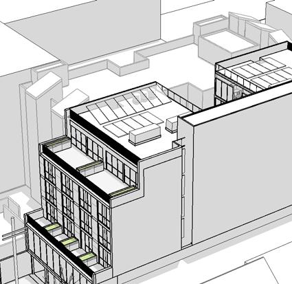


78 1 Aerial From South 2 Aerial from North 3 Aerial from West david baker architects 1178 Folsom LLC scale: date: A Folsom Aerial Massing Views
79 There are total of three (3) existing buildings on the site conecting by interior doors. The industrial and office buildings total of 9,600 sq.ft, and are one-to two-stories, and are up to 25-feet in height. There are currently no off-street parking spaces and three loading spaces david baker architects 1178 Folsom LLC scale: date: A Folsom Survey (existing condition)

80
81 &Jfi*mirit f*r ilirx{ **t-*9"** }*ii+"i,rp Fr*grmr:: i-]* r+j";*r,:,i i ::i f r:r rn"t f iti r,t 4@.-.f;=;'iift :",iil!!\-.5i;; iriirt.lt=11:'.i=i,i-iiii!'ilr::1r...il..:==--; i:,t;';;a...,:,-.::,:::i!iii,;i{i!ir!!:y::::.,,.,;4liiii1 Erik Liu -j,t:,.:a;:iifuii.i Folsom Street San Francisco, CA i-itl* l-.'*y":i;.r*.liir:i r *l llp*n.-:t-:i *i llril':+r1xtl i:;l r: 1+:* l t 415: ;tfeb::.1:.1=::::::::: iriitil# illlll {} }l{diffii:::::::::: 4lri::1;.;-;i:+i1{$.tS;,.-.-.'*iiii X.:;;;;l;i?iiuriiu.-:a#;:ria i?iiti!:,\::= ::' : i..jyj r eri k@transworldconstruction.com.t h*r'ehy c{e*larre tl: t* fii* b*:;t.*{ :x;r-kr:r*w}e-d.g,* ar*il thfl* xir**{# ** saltiply {lae p/zr/*,y iq{ iei\ri?ia n:4,i,i,";5 NF-is:t/;'.:
82 73 Sumner Street, #201 San Francisco, CA March 18, 2015 Richard Sucre Preservation Technical Specialist/Planner Southeast Quadrant, Current Planning Planning Department 1650 Mission Street, Suite 400 San Francisco, CA Dear Richard, The community met with Erik Liu, the owner of 1178 Folsom, and David Baker, the architect responsible for the design of the proposed building on Thursday, March 12, Around 10 neighbors attend and the meeting was cordial. We agreed that that a few items should be included as a matter of public record with the Planning Commission, and consist of: 1. delivery trucks would access the building form Folsom not Clementina as Clementina is too narrow and there is significant commercial traffic on the street already. Further, Erik agreed to add this to the house rules for the property; and, 2. trash cans will be placed in enclosed locked indoor space, cans to be retrieved from there by garbage pickup staff, and replaced there after emptying. We also agreed that an In Kind agreement would be optimal for the neighborhood. To this end we, will: 3. work with the Supervisor Kim and city on an in kind arrangement; 4. solicit street improvement ideas from the neighborhood for the in kind fees. We also discussed with a fair amount of understanding and willingness the following neighborhood recommendations: Trees: 5. place a large tree on Clementina so that it would provide an unobstructed view from Sumner Street. This would be accomplished by flipping the proposed location of the tree with the proposed location of the PG&E sidewalk vault. PG&E can make this change. (This has since been amended in recognition of the utility poll in the way; nevertheless, positioning the tree well to allow for maximum development is optimal.);
83 In a prior meeting and subsequent s, several neighbors recommended that the development include: 6. a watering system to both the Folsom and Clementina tree wells; 7. consider some interesting lighting for the trees on both frontages. Up lighting? 8. work with neighbors re the tree species selection; Sidewalk on Clementina: 9. neighbors stressed the use or reuse old granite curbing along Clementina; it s an old street and the old granite provides a nice historical context. Apparently, some folks in the city don t like doing this, but we hope it is not an unreasonable request; 10. consider a bulb out for Clementina frontage if possible, subject to city approval; 11. add planter wells to bulb out; Misc., but Very Important: 12. reduce car headlights from shining on the 73 Sumner building when they exit the garage; 13. re install one large bollard at the NE intersection of Sumner/Clementina to protect 73 Sumner from construction trucks during tear down and to protect 73 Sumner from additional traffic exiting and entering the garage; 14. consider adding yellow commercial parking spaces at the intersection of 8th/Clementina and Howard/Sumner Streets for delivery truck parking in an effort to reduce the over use of large commercial vehicles on Clementina and Sumner 15. consider rat abatement, which were a serious problems when the 60 Rausch, 1168 Folsom, and 73 Sumner developments started. Garage Location: The most controversial item was the proposed location of the garage on Clementina Street as opposed to Folsom Street. Although the controversy was diminished by the reduction in number of parking spaces to 9 from approximately 22, the addition of more traffic on Clementina Street is disappointing and sets a bad president. Specifically the proposed garage location on Clementina Street: 16. is not optimal given the small streets widths (Sumner is only 13 wide), number of residents, and current amount of traffic; 17. is not compliant with the Western Soma Task Force s recommendations that garages stay off of small feeder streets like Clementina;
84 18. will result in three garages and three building entrances coexisting within the Clementina dead end 1 all within 75 feet of each other; 19. will place the new garage within 100 feet of the 6,000 square foot parking lot owned currently used by a commercial company; 20. makes the alleyways the dumping ground for more traffic, which they were never designed for; 21. makes the area a dead zone for the neighborhood and makes it impossible to activate the space; 22. will result in car lights shining onto 73 Sumner; lastly and very importantly, 23. it sets a bad president for other developments with frontages on Folsom and the 600 block of Clementina. Approximately three other properties with similar frontages could propose this arrangement on the 600 block of Clementina, which as you know is a very narrow street. If unabated, this small half block could end up with as many as eight garage/driveway entrances on the alleyway. Such a possibility, would be completely impracticable. In closing, no one at the meeting expressed opposition to the development and, I believe, most meeting attendees believe the project will add to the neighborhood experience. We do have our difference on some issues especially the location of the garage, but are pleased that Erik Liu and the David Baker are willing to listen to folks who live and work in the neighborhood. Regards, John Dunlap 1 If permitted by the Planning Commission, there will be three garages within the Clementina Street dead end: 60 Rausch, 1168 Folsom and the proposed 1178 Folsom, plus three building entrances: 73 Sumner, 60 Rausch, and 1168 Folsom.

85 95 Brady Street San Francisco, CA Mr. Eric Liu Transworld Construction, Inc Folsom Street San Francisco, CA March 18, 2015 Ref: 1178 Folsom Street Mixed-Use Development Dear Mr. Liu, Thank you for bringing your proposed project for 1178 Folsom Street to the San Francisco Housing Action Coalition s (SFHAC) Project Review Committee on February 25, Following review, we endorse your project, believe it has merit and will contribute to SFHAC s mission of increasing the supply of well-designed, well-located housing that meets the needs of both present and future San Franciscans. This letter reflects our endorsement of your project and includes recommendations made by our members for modest improvements. We believe, however, that in general this project embodies the best principals of urban design. Please see our report card, which grades your proposal according to our guidelines. We have attached a copy of our project review guidelines for your reference. Project Description: The project proposes construction of 42 micro-units above one floor of office space and one floor of ground-floor retail, with one floor of subterranean parking. Land Use: Office space and a warehouse currently occupy the site. Housing is a much better use, considering the site s proximity to jobs, transit and neighborhood amenities. Density: The project takes advantage of the building envelope by proposing 42 well-designed micro-units that average about 350 square feet. Affordability: The project is not subject to the Inclusionary Housing Ordinance because the units are legally defined as Single-Occupancy-Rooms (SROs) under the Planning Code, meaning they are not dwelling units. However, these homes will be naturally more affordable than most new studios and would be within financial reach of more residents than most market-rate products. Parking and Alternative Transportation: The site is located along the Folsom Street Bicycle Corridor and is within walking distance to several Muni lines, BART and the Caltrain Station. We support your decision to provide nine parking spaces, a very low ratio, and 42 bicycle parking spaces in the garage and six Class II spaces at grade. We still encourage you to explore ways to increase the amount of bicycle parking since the bicycle usage in this area is so convenient. Preservation: There are no structures of significant cultural or historic merit on or near the site that would be affected by your project. The San Francisco Housing Action C oalition advocates for the creation of well-designed, well-loc ated housing, at A LL levels of affordability, to meet the needs of San Franciscans, present and future.
86 Mr. Eric Liu March 18, 2015 Page Two Urban Design: Our members support the design, including the setbacks in the front and back of the buildings, as well as the interior courtyard. The setback on the ground floor along Folsom Street will widen the sidewalk and improve the pedestrian experience. The rear of the building will also include a pedestrian plaza. All of these features promote good urbanism. Because this project is located within the Western SoMa Plan, the rooftop cannot contribute to the building s open space requirement, something we have never understood. Environmental Features: You indicated the rooftop could accommodate solar thermal or photovoltaic systems, but are still not certain of your plans. We encourage you to consider incorporating individual water sub-metering into the units. It s likely there will be local or statewide legislation mandating this before long. Community Input: We believe you have been thorough in your community outreach and successfully engaged the community. You have held four community meetings since December Thank you for submitting this project to the SFHAC Project Review Committee. We endorse it without reservation. Please keep us abreast of any changes and let us know how we may be of assistance. Sincerely, Tim Colen, Executive Director CC: Planning Commission
87 Mr. Eric Liu March 18, 2015 Page Three SFHAC Project Review Guidelines Land Use: Housing should be an appropriate use of the site given the context of the adjacent properties and the surrounding neighborhood and should enhance neighborhood livability. Density: The project should take full advantage of the maximum unit density and/or building envelope, allowable under the zoning rules. Affordability: The need for affordable housing, including middle income ( of Area Median Income) housing, is a critical problem and SFHAC gives special support to projects that propose creative ways to expand or improve unit affordability beyond the legally mandated requirements. Parking and Alternative Transportation: SFHAC expects the projects it endorses to include creative strategies to reduce the need for parking, such as ample bicycle storage, provision of space for car-share vehicles on-site or nearby, un-bundling parking cost from residential unit cost, and measures to incentivize transit use. Proximity to transit should result in less need for parking. In districts with an as-of-right maximum and discretionary approval up to an absolute maximum, SFHAC will support parking exceeding the as-of-right maximum only to the extent the Code criteria for doing so are clearly met. In districts where the minimum parking requirement is one parking space per residential unit (1:1), the SFHAC will not, except in extraordinary circumstances, support a project with parking in excess of that amount. Preservation: If there are structures of significant historic or cultural merit on the site, their retention and/or incorporation into the project consistent with historic preservation standards is encouraged. If such structures are to be demolished, there should be compelling reasons for doing so. Urban Design: The project should promote principles of good urban design: Where appropriate, contextual design that is compatible with the adjacent streetscape and existing neighborhood character while at the same time utilizing allowable unit density: pleasant and functional private and/or common open space; pedestrian, bicycle and transit friendly site planning; and design treatments that protect and enhance the pedestrian realm, with curb cuts minimized and active ground floor uses provided. Projects with a substantial number of multiple bedroom units should consider including features that will make the project friendly to families with children.
88 Mr. Eric Liu March 18, 2015 Page Four Environmental Features: SFHAC is particularly supportive of projects that employ substantial and/or innovative measures that will enhance their sustainability and reduce their carbon footprint. Community Input: Projects for which the developer has made a good faith effort to communicate to the community and to address legitimate neighborhood concerns, without sacrificing SFHAC s objectives, will receive more SFHAC support.
89 San Francisco Housing Action Coalition (SFHAC) Project Report Card Address: 1178 Folsom Street Project Sponsor: Erik Liu Date of SFHAC Review: February 25, 2015 Grading Scale: 1 = Fails to meet project review guideline criteria 2 = Meets some project review guideline criteria 3 = Meets basic project review guideline criteria 4 = Exceeds basic project review guideline criteria 5 = Goes far beyond of what is required Criteria for SFHAC Endorsement: 1. The project must have been presented to the SFHAC Project Review Committee; 2. The project must score a minimum of 3/5 on any given guideline. Guideline Comments Grade Land Use Office space and a warehouse currently occupy the site. Housing is a 5 much better use given the site s proximity to transit, jobs and neighborhood amenities. Density The project takes advantage of the building envelope by building 42 5 small, well-designed micro-units averaging 350 square feet. Affordability Parking and Alternative Transportation Preservation The project is not subject to the Inclusionary Housing Ordinance because the units are legally defined as SROs. But the small size of these homes will make them naturally affordable. The project proposes a low car-parking ratio, with only nine total spaces, as well as 42 Class I and six Class II bicycle parking spaces. The site is close to excellent transit amenities. There are no projects of significant cultural or historic merit on or near the site that would be affected by the proposed project. 4 5 N/A Urban Design Environmental Features Community Input Our members support the design, including setbacks in the front and back of the buildings, as well as the interior courtyard. The project strongly improves the pedestrian realm. There were no definitive plans yet, but the project sponsor indicated that the rooftop would include either solar thermal or photovoltaic systems. We urge installinig individual water metering for the units. The project sponsor has been thorough in engaging the community on the proposed project Additional Comments N/A Final Comments The SFHAC endorses the project without reservation. 4.6/5 Please see attached letter for further explanation.
90 Sucre, Richard (CPC) From: Sent: To: Cc: Subject: Colin Baptie Sunday, November 09, :13 AM Kim, Jane (BOS); Angulo, Sunny (BOS) Snyder, Mathew (CPC); Sucre, Richard (CPC) Folsom Street Project Dear Supervisor Kim, I agree with John s suggestions below and would very much like to see the developer of this project move the proposed garage entrance back to Folsom Street given the overuse of the small feeder streets. I also think that increased traffic on Sumner and Clementina Streets poses a public safety issue, especially given the number of homeless folk who use these streets and are at risk of being hit by a car. Looking forward to your thoughts. With regards, Colin Baptie 73 Sumner Street From: John W Dunlap <john@johndunlap.org> Date: Wednesday, October 29, 2014 at 8:00 AM To: "Kim, Jane (BOS)" <jane.kim@sfgov.org>, "Angulo, Sunny (BOS)" <sunny.angulo@sfgov.org> Subject: Folsom Street Project Hi Jane and Sunny, Just wanted to touch base and get your impressions on the proposed development at Folsom Street with frontage on Clementina Street. Although few would claim that the current buildings are appealing and should stay, certain aspects of the new development seem one-sided and a little deaf to community concerns. Of greatest concern is the planned location of the garage entrance on Clementina Street instead of continuing to use the very wide driveway on Folsom Street (see attached photo). The majority of people living around Clementina and Sumner Streets are not in favor of another garage entrance on Clementina given that this street, as well as Sumner, are very narrow, overused, feeder streets that were designed in the 1920s for limited amounts of traffic. In addition, another garage entrance on Clementina creates an ever expanding dead zone of garage facades that denudes/diminishes efforts to create the greater neighborhood feel we all seek. Lastly, and very importantly, adding another garage entrance on Clementina Street makes blocking off the lower section of Sumner Street and turning it into a small tree-lined pedestrian walkway less likely to happen. Another concern is the lack of interest in removing above ground utility lines on Clementina and/or Sumner Streets. As you know, the city and PG&E have a 75-year 1
91 plan to underground utilities in San Francsico, which is interminable. In effect, the neighborhood affected by the development would rather not wait decades for this improvement and instead is seeking this improvement as part of the development process. Perhaps there is a way to fast track city plans by combining city and developer funds for such an improvement? In addition, we are concerned that impact fees paid by the developer are not earmarked for improvements in the neighborhood. Ideally, these fees would be used to help with the envisioned pedestrian alleyway improvements mentioned above, with the undergrounding of utility lines, or a combination of the two. Further among other options, such funds could assist in partially funding the development of a park at the intersection of Sumner and Clementina where a parking lot currently exists. Of course these and other ideas require further input from the neighborhood. I am taking the liberty of forwarding this to neighbors residing on Rausch and Langton Streets. They are currently dealing with a similar issue in which a proposed project at 1140 Folsom Street places the garage on Rausch rather than Folsom Street. I can t speak for this group, but I believe they share a common interest in how the developer and city reconcile neighborhood interests. Lastly, I would be pleased to host a meeting with Sumner, Clementina, plus Rausch and Langton Street neighbors, to talk in more detail about our shared concerns. Please let me know if such a meeting would be beneficial. Your thoughts are very much appreciated. Regards, John Dunlap 73 Sumner St. #201 San Francisco, CA john@johndunlap.org From: "Sucre, Richard (CPC)" <richard.sucre@sfgov.org> Date: Wednesday, October 15, 2014 at 2:44 PM To: John W Dunlap <john@johndunlap.org> Cc: "brett.becker@sfgov.org" <brett.becker@sfgov.org> Subject: RE: 1174 Folsom St Updated Plans Hi John, 2
92 I am progressing with my review of the plans for 1174 Folsom St. A set of revisions was sent to me on September 8 th, in response to my initial notice. The garage is still specified on Clementina Street. Let me know if you have any questions. Rich Richard Sucre Preservation Technical Specialist/Planner, Southeast Quadrant, Current Planning Planning Department City and County of San Francisco 1650 Mission Street, Suite 400, San Francisco, CA Direct: Fax: richard.sucre@sfgov.org 3
93 Pedram Farashbandi David Baker Architects 461 2nd Street, Loft C-127 San Francisco, CA March 18, 2015 Ref: 1178 Folsom Street Mixed-Use Development Dear Mr. Farashbandi, As the owner of 1168 Folsom St, the 22 unit adjoining apartment building, I want to thank you and the owners for accommodating my request to move the light well in your building to the east side which helps bring more light into our units. I have no other objection to your building and believe it will benefit the area and surrounding properties if it were built. You can tell the planning commission that I fully support its approval. Sincerely, John Shalavi Bridge Capital Partners Inc. Tel: (415) Fax: (415) john@bcpartnersinc.com 700 Larkspur Landing Circle Suite #208 Larkspur, CA 94939
94 Sucre, Richard (CPC) From: Sent: To: Cc: Subject: Jim Meko Saturday, October 04, :12 PM Rahaim, John (CPC); Sucre, Richard (CPC); Jaszewski, Erik (CPC) Kim, Jane (BOS); Cindy Wu; Kathrin Moore; Mike Antonini; Dennis Richards don't dump more cars into our alleys Our Residential Enclave Districts (REDs), the network of small alleys of Western SoMa, are the heart and soul of our community. To preserve and enhance these residential neighborhoods was so important to the fabric of our community that the Board of Supervisors wrote this mandate into Board of Supervisors Resolution : "... map and evaluate land uses proximate to existing and proposed REDs and develop basic height, density and design guidelines in order to provide a buffer between REDs and areas where more intense development might be allowed." In other words, this community made a deal with the city: we will accept increased density and development but only if you don't screw up what we already have. Several projects are currently moving through the pipeline and the Planning Department has returned to business as usual. Anything unpleasant, inconvenient or ugly gets dumped into the alleys. Garage entrances and exits fall into that category. Project sponsors at 1140 Folsom Street and 1178 Folsom Street are being told that their parking must empty into the alleys. The REDs are already unsafe. Cars race through these narrow streets, using them as shortcuts to the freeways, damaging parked cars along the way. The neighbors on Sumner Street, where the developer of 1178 Folsom Street has been told to exit his garage, have been trying to find funds for traffic calming measures for years. More traffic would endanger pedestrians, children and bicyclists. Neighbors are furious that your recommendations will further compromise their safety and quality of life. The standard for parking on the Folsom Street Neighborhood Commercial District, as stated in the draft Design Standards for Western SoMa, discourages garage entrances and exits in the adjacent alleys: "Access to off-street loading and parking spaces shall be from the main streets in preference to pedestrian and bicycle use of alleys." In addition, the Residential Enclave District standards state, "Where a property fronts both a main street and an alley, access to off-street loading and parking spaces shall be designed to be appropriate for both streets and when possible should discourage alley facades that do not respond to the design details of proximate alley building frontage details. Parking access, when possible, shall be from the main streets with preference to pedestrian and bicycle use of alleys." Folsom Street is not a freeway. It is identified in the Western SoMa Community Plan as a "neighborhoodserving street." The Plan recommends that "all pass-through traffic should be channeled along [regionalserving] streets leading to/from established freeway on-ramps/off-ramps." The east/west regional-serving streets are in the light industrial area south of Harrison Street, not on our neighborhood commercial corridor. 1
95 Former Director of Current Planning Jose Campos assured me that "until there is an alternative, the Western SoMa draft [design] standards will be used in the meantime to inform the designs of new buildings in Western SoMa." Your recommendation is in direct conflict with his promise. Jim Meko, former chair, Western SoMa Citizens Planning Task Force (415) office (415) cell (415) fax 2
96 Sucre, Richard (CPC) From: Sent: To: Subject: Ardalan Payvar Wednesday, November 26, :34 PM Sucre, Richard (CPC); Snyder, Mathew (CPC); Kim, Jane (BOS); Angulo, Sunny (BOS); John Dunlap Folsom Street Development Dear All, My name is Ardalan Payvar I'm a resident/owner in 73 Sumner Street building (#402). I was informed that the developer of Folsom Street building is planning to have a garage entrance on Clemetina Street. Keeping in mind that two more garage entrances already exist at Sumner/Clementina intersection, this addition will cause too much traffic for such a small and narrow street. We're already having problems with cars from different buildings arriving at the same time and not being able to enter into the garages. Adding a third garage entrance will sure create more conflict. Also, with future plans to turn Clementina/Sumner intersection into a green pedestrian walk-way, it'd be wise to keep traffic to a minimum. I'm certain that future owners at the Folsom development would also prefer to live on a tree-lined street with a pedestrian walk-way and a park, as opposed to an alley with too much car traffic. After all, they'll be part of this neighborhood community as well. I'm sure other neighbors have expressed similar concerns and I'd appreciate if you took these suggestions into consideration. Sincerely, Ardalan Payvar 73 Sumner Street, #402 San Francisco, CA
97 Sucre, Richard (CPC) From: Sent: To: Subject: Dennis Spain Monday, November 10, :11 PM Sucre, Richard (CPC) Folsom Street Project Richard Sucre Preservation Technical Specialist South Quadrant Dear Mr. Sucre As a ground floor owner that faces Clementina Street, I wish to register my strong opposition to the proposed garage access of the Folsom Street Project on to Clementina Street. Anyone trying to drive on Clementina Street knows that it is very narrow and does not accommodate two-way traffic without forcing one vehicle out of the roadway. With additional traffic, we risk turning Clementina into an alley to the detriment of those of us with homes that open to the street. For the local neighbors, Clementina Street is our front yard not a driveway serving high rise residents. In the not too distant future as private automobile traffic becomes less attractive in the city, Clementina Street should more appropriately become a pedestrian walkway or park. Further there appears to be a perfectly adequate driveway / entrance solution for the project on Folsom Street. I feel that the developers are proposing to sacrifice the neighborhood ambiance and future livability in order to have the small short term gain of additional Folsom Street store frontage. We are really going to have this opportunity only once in our lifetime if we want to create a pedestrian friendly and esthetically attractive neighborhood. While I welcome the project as a positive contribution to the South-of- Market community, I object to the disregard the developers have shown to the local neighbors and the future, especially since simple relocation of the garage entrance appears to be such an obvious solution. Regards Dennis Spain 1
98 73 Sumner Street, #101 San Francisco, CA
99 Sucre, Richard (CPC) From: Sent: To: Subject: Brian Wallace Sunday, November 23, :35 PM Sucre, Richard (CPC) Prosed Development at Folsom Street Dear Richard Sucre, My neighbors living at the intersection of Clementina and Sumner Streets have informed me that the project sponsor for a residential building to be constructed at Folsom Street is considering placing their garage on the Clementina side of the building, rather than on the Folsom side. I strongly urge the project sponsor to reconsider this decision and design. The tiny intersection of Clementina and Sumner Streets is such a precious South of Market jewel, a charming little oasis, quietly tucked away from the surrounding hubbub. Placing a garage entrance on Clementina creates an ever expanding dead zone of garage facades that diminishes all the efforts expended so far to create a greater neighborhood feel. Bottom line: Keep the garage entrance on Folsom Street. The Recology trucks are going to be there anyway to pick up trash for all the other properties on the 1100 block of Folsom Street. There is no compelling reason to route their trucks down Clementina Street. It makes more sense to keep that entrance as a pedestrian-only entrance. Thank you, Brian Wallace 473-A Tehama Street San Francisco, CA somawally@comcast.net 1
100 Sucre, Richard (CPC) From: Sent: To: Cc: Subject: Mari Zatman Wednesday, November 05, :32 AM Angulo, Sunny (BOS); Kim, Jane (BOS); Sucre, Richard (CPC) john Dunlap Folsom Street project Hi Jane, Richard, and Sunny, regarding the Folsom Street project (with frontage on Clementina) I am a resident living at 3 Sumner Alley. I am NOT in favor of this project having access to frontage on Clementina. Sumner is already way to busy and used by far to many cars and other vehicles. We have been neglected for far to long and we seem to have no priority to have any help or improvements. Please do NOT allow this new project to add more insult to our quality of life. mari Mari Zatman (415) cell Sumner Alley, San Francisco CA Grouptravel4u@gmail.com Group Travel 4U / Zatman Marketing, Inc. GREEN HOUSING and MEETING SPECIALIST 1
101 SAN FRANCISCO PLANNING DEPARTMENT Certificate of Determination EXEMPTION FROM ENVIRONMENTAL REVIEW Case No.: E Project Title: Zoning/Plan Area: Folsom NCT (Folsom Neighborhood Commercial Transit) District 65-X Height and Bulk District Western SoMa Community Plan Block/Lot: 3730/023, 024 Lot Size: 2 lots totaling 8,000 square feet Project Sponsor: Erik Liu; 1178Folsom LLC (415) Staff Con tact: Brett Becker, (415) , Brett.Becker@sfgov.org 1650 Mission St. Suite 400 San Francisco, CA Reception: Fax: Planning Information: PROJECT DESCRIPTION The proposed project includes the following: 1) merging two 4,000-square-foot lots; 2) demolition of two existing one- and two-story warehouse/office buildings which total 9,600 square feet; and 3) construction of a new six-story, 65-foot tall, 42,781-square-foot mixed-use building with basement garage. The existing buildings were built circa 1952/1970 and are located within the eligible Western SoMa Light Industrial and Residential Historic District. EXEMPT STATUS (Continued on next page) Exempt per Section of the California Environmental Quality Act (CEQA) Guidelines and California Public Resources Code Section DETERMINATION I do hereby certify that the above determination has been made pursuant to State and Local requirements. SARAH B. J Environmental Review Officer 4k1 Date cc: Erik Liu, Project Sponsor Virna Byrd, M.D.F. Rich Sucre, Current Planner Exclusion/Exemption Dist. List Supervisor Jane Kim, District 6 Historic Preservation Dist. List
102 Certificate of Exemption Case No E PROJECT DESCRIPTION (continued) The new building would be constructed on a slab foundation and would include 3,990 square feet of retail space on the ground floor, 5,988 square feet of office space on the second floor, and 14,758 square feet of residential space with 42 single-room occupancy (SRO) dwelling units on the remaining floors. The 5,942 square-foot basement level garage would involve up to 14 feet of soil disturbance and would require the excavation of approximately 5,000 cubic yards of soil. The garage would be accessed from Clementina Street and would contain 9 off-street vehicle parking spaces, 48 Class 1 bicycle parking spaces, and 6 Class 2 bicycle parking spaces. The project would provide private open space for six dwelling units and approximately 1,658 square feet of common useable open space via a roof deck and court terrace for the remaining dwelling units. The project site is located within the Western SoMa Community Plan Area on the block bound by Clementina, 8 th, Folsom, and Rausch Streets. PROJECT APPROVAL The proposed project would require the following approvals: Conditional Use Authorization (Planning Commission) Variance (Planning Department) Building Permit (Department of Building Inspection) The proposed project is subject to Conditional Use Authorization from the Planning Commission, which is the Approval Action for the project. The Approval Action date establishes the start of the 30-day appeal period for this CEQA exemption determination pursuant to Section 31.04(h) of the San Francisco Administrative Code. COMMUNITY PLAN EXEMPTION OVERVIEW California Public Resources Code Section and CEQA Guidelines Section provide an exemption from environmental review for projects that are consistent with the development density established by existing zoning, community plan or general plan policies for which an Environmental Impact Report (EIR) was certified, except as might be necessary to examine whether there are projectspecific significant effects which are peculiar to the project or its site. Section specifies that examination of environmental effects shall be limited to those effects that: a) are peculiar to the project or parcel on which the project would be located; b) were not analyzed as significant effects in a prior EIR on the zoning action, general plan or community plan with which the project is consistent; c) are potentially significant off-site and cumulative impacts that were not discussed in the underlying EIR; or d) are previously identified in the EIR, but which, as a result of substantial new information that was not known at the time that the EIR was certified, are determined to have a more severe adverse impact than that discussed in the underlying EIR. Section 15183(c) specifies that if an impact is not peculiar to the parcel or to the proposed project, then an EIR need not be prepared for the project solely on the basis of that impact. This determination evaluates the potential project-specific environmental effects of the Folsom Street project described above, and incorporates by reference information contained in the Programmatic EIR for the Western SoMa Community Plan, Rezoning of Adjacent Parcels, and 350 Eight Street Project 2
103 Certificate of Exemption Case No E (Western SoMa Community Plan PEIR) 1. Project-specific studies were prepared for the proposed project to determine if the project would result in any significant environmental impacts that were not identified in the Western SoMa PEIR. The Western SoMa PEIR included analyses of the following environmental issues: land use; aesthetics; population and housing; cultural and paleontological resources; transportation and circulation; noise and vibration; air quality; greenhouse gas emissions; wind and shadow; recreation; public services, utilities, and service systems; biological resources; geology and soils; hydrology and water quality; hazards and hazardous materials; mineral and energy resources; and agricultural and forest resources. The site is located in the Western SoMa Community Plan. As a result of the Western SoMa rezoning process, the project site has been rezoned to a 65-X Height and Bulk District, as well as a Folsom Street Neighborhood Commercial Transit (NCT) District. The Folsom Street NCT District is intended to protect the balance and variety of ground-floor retail uses along the ground floor, and promote housing in the floors above. The proposed project is consistent with uses permitted within the Folsom Street NCT Districts. Individual projects that could occur in the future under the Western SoMa Community Plan will undergo project-level environmental evaluation to determine if they would result in further impacts specific to the development proposal, the site, and the time of development and to assess whether additional environmental review would be required. This determination concludes that the proposed project at is consistent with and was encompassed within the analysis in the Western SoMa PEIR. This determination also finds that the Western SoMa PEIR adequately anticipated and described the impacts of the proposed project, and identified the mitigation measures applicable to the project. The proposed project is also consistent with the zoning controls and the provisions of the Planning Code applicable to the project site. 2,3 Therefore, no further CEQA evaluation for the project is required. In sum, the Western SoMa PEIR and this Certificate of Exemption for the proposed project comprise the full and complete CEQA evaluation necessary for the proposed project. PROJECT SETTING The block of Folsom Street between 7 th and 8 th Streets, on which the project site is located, consists of retail, residential, commercial, and office uses. The surrounding buildings vary in appearance and height; the existing two story buildings are generally industrial in character and consist of masonry construction, while the taller four- to six-story buildings are of more modern appearance characterized by stucco, steel, and glass. Several tall five- to six-story residential buildings line both sides of the Folsom Street block, interspersed with the low-rise industrial-style buildings. The existing warehouse/office buildings are currently being used for office and storage space. Immediate surrounding properties to the project site along Folsom Street include commercial/warehouse buildings and a five-story 65-foot tall multi-family residential building. The project site is located within 25 feet of a Historic District contributor (three-and- 1 Planning Department Case Nos E and E, State Clearinghouse No Adam Varat, San Francisco Planning Department, Community Plan Exemption Eligibility Determination, Citywide Planning Analysis,, March 25, This document is on file and available for review as part of Case File No E. 3 Jeff Joslin, San Francisco Planning Department, Community Plan Exemption Eligibility Determination, Current Planning Analysis,, January 30, This document is on file and available for review as part of Case File No E. 3
104 Certificate of Exemption Case No E a-half-story, Queen Anne Style, wood frame residential building) at Clementina Street (one building away from the project site). POTENTIAL ENVIRONMENTAL EFFECTS The proposed project is in conformance with the height, use and density for the site described in the Western SoMa PEIR and would represent a small part of the growth that was forecast for the Western SoMa Community Plan. Thus, the project analyzed in the Western SoMa PEIR considered the incremental impacts of the proposed project. As a result, the proposed project would not result in any new or substantially more severe impacts than were identified in the Western SoMa PEIR. Significant and unavoidable impacts were identified for the following topics: historic resources, transportation and circulation, noise, air quality, and shadow. As described above, the proposed project includes demolition of two existing warehouse/office buildings built in 1952/1970 that are located within the eligible Western SoMa Light Industrial and Residential Historic District (Historic District). This Historic District developed primarily between the years 1906 and 1936 and consists of a group of resources that are cohesive in regard to scale, building typology, materials, architectural style, and relationship to the street. According to the Historic Resource Evaluation Report (HRER) prepared for the project, 4 neither of these buildings would qualify as a historic resource and were determined to be noncontributors to the Historic District since they were built after the period of significance of the Historic District and have low architectural value. Further, the HRER found that the proposed design of the new building would be compatible with the Historic District and would not cause a substantial adverse change in the significance of the Historic District. Therefore, the project would not contribute to a historic resource impact. Traffic and transit ridership generated by the project would not considerably contribute to the traffic and transit impacts identified in the Western SoMa PEIR. The Western SoMa PEIR identified feasible mitigation measures to address significant impacts related to cultural and paleontological resources, transportation and circulation, noise and vibration, air quality, wind, biological resources, and hazards and hazardous materials. Table 1 below lists the mitigation measures identified in the Western SoMa PEIR and states whether each measure would apply to the proposed project. Table 1 Western SoMa PEIR Mitigation Measures Mitigation Measure Applicability D. Cultural and Paleontological Resources M-CP-1a: Documentation of a Historical Resource M-CP-1b: Oral Histories M-CP-1c: Interpretive Program Not Applicable: site is not a historic resource and is not located in a historic district Not Applicable: site is not a historic resource and is not located in a historic district Not Applicable: site is not a historic resource 4 Historic Resource Evaluation Report,, December 23, This document is on file and available for public review at the San Francisco Planning Department, 1650 Mission Street, Suite 400, as part of Case File No E. 4
105 Certificate of Exemption Case No E Mitigation Measure Applicability and is not located in a historic district M-CP-4a: Project-Specific Preliminary Archeological Assessment M-CP-4b: Procedures for Accidental Discovery of Archeological Resources M-CP-7a: Protect Historical Resources from Adjacent Construction Activities M-CP-7b: Construction Monitoring Program for Historical Resources Applicable: soil disturbing activities proposed Applicable: soil disturbing activities proposed Applicable: one adjacent historic resource present Applicable: one adjacent historic resource present E. Transportation and Circulation M-TR-1c: Traffic Signal Optimization (8 th /Harrison/I-80 WB off-ramp) M-TR-4: Provision of New Loading Spaces on Folsom Street M-C-TR-2: Impose Development Impact Fees to Offset Transit Impacts Not Applicable: plan level mitigation by SFMTA Not Applicable: project would not remove loading spaces along Folsom Street Not Applicable: transit ridership generated by project would not considerably contribute to impact F. Noise and Vibration M-NO-1a: Interior Noise Levels for Residential Uses M-NO-1b: Siting of Noise-Sensitive Uses M-NO-1c: Siting of Noise-Generating Uses M-NO-1d: Open Space in Noisy Environments M-NO-2a: General Construction Noise Control Measures M-NO-2b: Noise Control Measures During Pile Driving Applicable: project would site residential use along noisy street Applicable: project would site noise-sensitive use along noisy street Not Applicable: project is not proposing a noise-generating use Applicable: project includes open space in a noisy environment Applicable: project includes construction activities Not Applicable: project would not include piledriving activities G. Air Quality M-AQ-2: Transportation Demand Management Strategies for Future Development Projects M-AQ-3: Reduction in Exposure to Toxic Air Contaminants for New Sensitive Receptors Not Applicable: project would not generate more than 3,500 daily vehicle trips Applicable: project would site sensitive receptors in an area of poor air quality 5
106 Certificate of Exemption Case No E Mitigation Measure M-AQ-4: Siting of Uses that Emit PM2.5 or other DPM and Other TACs M-AQ-6: Construction Emissions Minimization Plan for Criteria Air Pollutants M-AQ-7: Construction Emissions Minimization Plan for Health Risks and Hazards Applicability Not Applicable: project-related construction and operation would not introduce substantial emissions Applicable: project includes construction in an area of poor air quality Applicable: project includes construction in an area of poor air quality I. Wind and Shadow M-WS-1: Screening-Level Wind Analysis and Wind Testing Not Applicable: project would not exceed 80 feet in height L. Biological Resources M-BI-1a: Pre-Construction Special-Status Bird Surveys M-BI-1b: Pre-Construction Special-Status Bat Surveys Applicable: project includes building demolition Applicable: project includes building demolition O. Hazards and Hazardous Materials M-HZ-2: Hazardous Building Materials Abatement M-HZ-3: Site Assessment and Corrective Action Applicable: project includes demolition of a pre-1970s building Not Applicable: superseded by Health Code Article 22A (Maher Ordinance) As analyzed and discussed in the CPE Checklist, the following mitigation measures identified in the PEIR do not apply to the proposed project: M-CP-1a, M-CP-1b, M-CP-1c, M-TR-1c, M-TR-4, M-C-TR-2, M-NO- 1c, M-NO-2b, M-AQ-2, M-AQ-4, M-HZ-3. As discussed in the CPE Checklist, Western SoMa PEIR Mitigation Measures M-CP-4a, M-CP-4b, M-CP- 7a, and M-CP-7b were determined to apply to the proposed project as the project would involve soil disturbing activities in an archeologically sensitive area and demolition/construction activities adjacent to a historic resource. Mitigation Measures M-NO-1a, M-NO-1b, M-NO-1d and M-NO-2a were determined to apply to the proposed project as the project would include construction, siting of open space, and siting of noise-sensitive residential uses in a noisy environment. Mitigation Measures M-AQ-3, M-AQ-6, and M-AQ-7 were determined to apply to the proposed project as the project would include construction and siting of sensitive receptors in an area of poor air quality. Mitigation Measures M-BI-1a and M-BI-1b were determined to apply to the proposed project as the project would demolish an existing building that could contain bird or bat species. Mitigation Measure M-HZ-2 was determined to apply to the proposed project as the project would include demolition of a building constructed before Please see the attached Mitigation Monitoring and Reporting Program (MMRP) for the complete text of the applicable mitigation measures. 6
107 Certificate of Exemption Case No E With implementation of these mitigation measures the proposed project would not result in significant impacts beyond those analyzed in the Western SoMa PEIR. PUBLIC NOTICE AND COMMENT A Notification of Project Receiving Environmental Review was mailed on January 3, 2014 to adjacent occupants and owners of properties within 300 feet of the project site. Concerns and issues raised by the public in response to the notice were taken into consideration and incorporated in the environmental review as appropriate for CEQA analysis. One comment was received regarding physical environmental effects. This comment was related to the proposed building s height and bulk, in that the proposed building would be close to and taller than the neighboring residential building and could affect the availability of natural light for the adjacent residents. The new mixed-use residential building would be visible from and adjacent to some residential and commercial buildings within the project site vicinity, which could reduce private views from some locations and natural light on nearby private property and buildings. Reduced private views and natural light on private property and buildings would be an unavoidable consequence of the proposed project and may be an undesirable change for those individuals affected. Nonetheless, the change in private views and natural light on private property and buildings would not exceed those commonly expected in an urban setting and would not constitute a significant impact under CEQA. The proposed project would not result in significant adverse environmental impacts associated with the issues identified by the public beyond those identified and disclosed in the Western SoMa PEIR. CONCLUSION As summarized above and further discussed in the CPE Checklist 5 : 1. The proposed project is consistent with the development density established for the project site in the Western SoMa Community Plan; 2. The proposed project would not result in effects on the environment that are peculiar to the project or the project site that were not identified as significant effects in the Western SoMa PEIR; 3. The proposed project would not result in potentially significant off-site or cumulative impacts that were not identified in the Western SoMa PEIR; 4. The proposed project would not result in significant effects, which, as a result of substantial new information that was not known at the time the Western SoMa PEIR was certified, would be more severe than were already analyzed and disclosed in the PEIR; and 5. The project sponsor will undertake feasible mitigation measures specified in the Western SoMa PEIR to mitigate project-related significant impacts. Therefore, the proposed project is exempt from further environmental review pursuant to Public Resources Code Section and CEQA Guidelines Section The CPE Checklist is available for review at the Planning Department, 1650 Mission Street, Suite 400, San Francisco, in Case File No E. 7
108 Mitigation Monitoring and Reporting Program MITIGATION MONITORING AND REPORTING PROGRAM Mitigation Measures Responsibility for Implementation Mitigation Schedule Monitoring/ Reporting Responsibility Status/Date Completed Historic Resources Project Mitigation Measure 1 - Protect Historical Resources from Adjacent Construction Activities (Mitigation Measure M-CP-7a of the Western SoMa PEIR) The project sponsor of a development project in the Draft Plan Area and on the Adjacent Parcels shall consult with Planning Department environmental planning/preservation staff to determine whether adjacent or nearby buildings constitute historical resources that could be adversely affected by construction generated vibration. For purposes of this measure, nearby historic buildings shall include those within 100 feet of a construction site if pile driving would be used in a subsequent development project; otherwise, it shall include historic buildings within 25 feet if heavy equipment would be used on the subsequent development project. (No measures need be applied if no heavy equipment would be employed.) If one or more historical resources is identified that could be adversely affected, the project sponsor shall incorporate into construction specifications for the proposed project a requirement that the construction contractor(s) use all feasible means to avoid damage to adjacent and nearby historic buildings. Such methods may include maintaining a safe distance between the construction site and the historic buildings (as identified by the Planning Department preservation staff), using construction techniques that reduce vibration, appropriate excavation shoring methods to prevent movement of adjacent structures, and providing adequate security to minimize risks of vandalism and fire. Project Mitigation Measure 2 - Construction Monitoring Program for Historical Resources (Mitigation Measure M-CP-7b of the Western SoMa PEIR) For those historical resources identified in Mitigation Measure M CP 7a, and where heavy equipment would be used on a subsequent development project, the project sponsor of such a project shall undertake a monitoring program to minimize damage to adjacent historic buildings and to ensure that any such damage is documented and repaired. The monitoring Project sponsor/ contractor(s)/ Planning Department s ERO Prior to any demolition or construction activities Project sponsor/contractor(s) Considered complete upon ERO s approval of construction specifications Project sponsor/ contractor(s)/ qualified historic preservation professional/ Planning Department s ERO Prior to the start of demolition, earth moving, or construction activity proximate to a designated historical resource Planning Department Preservation Technical Specialist shall review and approve construction monitoring program Considered complete upon submittal to ERO of post-construction report on construction monitoring program and MMRP-1 Case No E
109 Mitigation Monitoring and Reporting Program Mitigation Measures Responsibility for Implementation Mitigation Schedule Monitoring/ Reporting Responsibility Status/Date Completed program, which shall apply within 100 feet where pile driving would be used and within 25 feet otherwise, shall include the following components. Prior to the start of any ground-disturbing activity, the project sponsor shall engage a historic architect or qualified historic preservation professional to undertake a pre construction survey of historical resource(s) identified by the San Francisco Planning Department within 125 feet of planned construction to document and photograph the buildings existing conditions. Based on the construction and condition of the resource(s), the consultant shall also establish a maximum vibration level that shall not be exceeded at each building, based on existing condition, character defining features, soils conditions, and anticipated construction practices (a common standard is 0.2 inch per second, peak particle velocity). To ensure that vibration levels do not exceed the established standard, the project sponsor shall monitor vibration levels at each structure and shall prohibit vibratory construction activities that generate vibration levels in excess of the standard. effects, if any, on proximately historical resources Should vibration levels be observed in excess of the standard, construction shall be halted and alternative construction techniques put in practice, to the extent feasible. (For example, pre drilled piles could be substituted for driven piles, if feasible based on soils conditions; smaller, lighter equipment might be able to be used in some cases.) The consultant shall conduct regular periodic inspections of each building during ground-disturbing activity on the project site. Should damage to either building occur, the building(s) shall be remediated to its pre construction condition at the conclusion of grounddisturbing activity on the site. Cultural Resources Project Mitigation Measure 3 Archeological Testing Program (Mitigation Measure M-CP-4a of the Western SoMa PEIR) Project sponsors wishing to obtain building permits from the City are required to undergo environmental review pursuant to CEQA. The San Francisco Planning Department, as the Lead Agency, requires an evaluation of the potential archeological effects of a proposed individual project. Pursuant to this evaluation, the San Francisco Planning Department has Project sponsor/ Planning Department s archeologist or qualified archeological consultant/ Planning Department s ERO Prior to issuance of a building permit Planning Department s archeologist or qualified archeological consultant/ Planning Department s ERO Considered complete upon submittal of PAR or PASS to ERO or designated Planning Department staff MMRP-2 Case No E
110 Mitigation Monitoring and Reporting Program Mitigation Measures Responsibility for Implementation Mitigation Schedule Monitoring/ Reporting Responsibility Status/Date Completed established a review procedure that may include the following actions, carried out by the Department archeologist or by a qualified archeological consultant, as retained by the project sponsor. This archeological mitigation measure shall apply to any project involving any soils-disturbing or soils improving activities including excavation, utilities installation, grading, soils remediation, compaction/chemical grouting to a depth of five (5) feet or greater below ground surface and located within properties within the Draft Plan Area or on the Adjacent Parcels for which no archeological assessment report has been prepared. Projects to which this mitigation measure applies shall be subject to Preliminary Archeology Review (PAR) by the San Francisco Planning Department archeologist. As the PAR determined that the project has the potential to adversely affect archeological resources, an Archeological Testing Program is required. The Program would more definitively identify the potential for California Register eligible archeological resources to be present within the project site and determine the appropriate action necessary to reduce the potential effect of the project on archeological resources to a less than-significant level. The Archeological Testing Program is detailed below. A. Consultation with Descendant Communities. On discovery of an archeological site 1 associated with descendant Native Americans, the Overseas Chinese, or other descendant group an appropriate representative 2 of the descendant group and the Environmental Review Officer (ERO) shall be contacted. The representative of the descendant group shall be given the opportunity to monitor archeological field investigations of the site and to consult with 1 The term archeological site is intended here to minimally include any archeological deposit, feature, burial, or evidence of burial. 2 An appropriate representative of the descendant group is here defined to mean, in the case of Native Americans, any individual listed in the current Native American Contact List for the City and County of San Francisco maintained by the California Native American Heritage Commission and in the case of the Overseas Chinese, the Chinese Historical Society of America. An appropriate representative of other descendant groups should be determined in consultation with the Department archeologist. MMRP-3 Case No E
111 Mitigation Monitoring and Reporting Program Mitigation Measures Responsibility for Implementation Mitigation Schedule Monitoring/ Reporting Responsibility Status/Date Completed ERO regarding appropriate archeological treatment of the site, of recovered data from the site, and, if applicable, any interpretative treatment of the associated archeological site. A copy of the Final Archaeological Resources Report shall be provided to the representative of the descendant group. B. Archeological Testing Program. The archeological consultant shall prepare and submit to the ERO for review and approval an archeological testing plan (ATP). The archeological testing program shall be conducted in accordance with the approved ATP. The ATP shall identify the property types of the expected archeological resource(s) that potentially could be adversely affected by the proposed project, the testing method to be used, and the locations recommended for testing. The purpose of the archeological testing program will be to determine to the extent possible the presence or absence of archeological resources and to identify and to evaluate whether any archeological resource encountered on the site constitutes an historical resource under CEQA. At the completion of the archeological testing program, the archeological consultant shall submit a written report of the findings to the ERO. If based on the archeological testing program the archeological consultant finds that significant archeological resources may be present, the ERO in consultation with the archeological consultant shall determine if additional measures are warranted. Additional measures that may be undertaken include additional archeological testing, archeological monitoring, and/or an archeological data recovery program. No archeological data recovery shall be undertaken without the prior approval of the ERO or the Planning Department archeologist. If the ERO determines that a significant archeological resource is present and that the resource could be adversely affected by the proposed project, at the discretion of the project sponsor either: a) The proposed project shall be re-designed so as to avoid any adverse effect on the significant archeological MMRP-4 Case No E
112 Mitigation Monitoring and Reporting Program Mitigation Measures Responsibility for Implementation Mitigation Schedule Monitoring/ Reporting Responsibility Status/Date Completed resource; or b) A data recovery program shall be implemented, unless the ERO determines that the archeological resource is of greater interpretive than research significance and that interpretive use of the resource is feasible. C. Archeological Monitoring Program. If the ERO in consultation with the archeological consultant determines that an archeological monitoring program shall be implemented the archeological monitoring program (AMP) shall minimally include the following provisions: The archeological consultant, project sponsor, and ERO shall meet and consult on the scope of the AMP reasonably prior to any project-related soils disturbing activities commencing. The ERO in consultation with the archeological consultant shall determine what project activities shall be archeologically monitored. In most cases, any soils- disturbing activities, such as demolition, foundation removal, excavation, grading, utilities installation, foundation work, driving of piles (foundation, shoring, etc.), site remediation, etc., shall require archeological monitoring because of the risk these activities pose to potential archaeological resources and to their depositional context; The archeological consultant shall advise all project contractors to be on the alert for evidence of the presence of the expected resource(s), of how to identify the evidence of the expected resource(s), and of the appropriate protocol in the event of apparent discovery of an archeological resource; The archeological monitor(s) shall be present on the project site according to a schedule agreed upon by the archeological consultant and the ERO until the ERO has, in consultation with project archeological consultant, MMRP-5 Case No E
113 Mitigation Monitoring and Reporting Program Mitigation Measures Responsibility for Implementation Mitigation Schedule Monitoring/ Reporting Responsibility Status/Date Completed determined that project construction activities could have no effects on significant archeological deposits; The archeological monitor shall record and be authorized to collect soil samples and artifactual/ecofactual material as warranted for analysis; If an intact archeological deposit is encountered, all soilsdisturbing activities in the vicinity of the deposit shall cease. The archeological monitor shall be empowered to temporarily redirect demolition/excavation/pile driving/construction activities and equipment until the deposit is evaluated. If, in the case of pile driving activity (foundation, shoring, etc.), the archeological monitor has cause to believe that the pile-driving activity may affect an archeological resource, the pile-driving activity shall be terminated until an appropriate evaluation of the resource has been made in consultation with the ERO. The archeological consultant shall immediately notify the ERO of the encountered archeological deposit. The archeological consultant shall make a reasonable effort to assess the identity, integrity, and significance of the encountered archeological deposit, and present the findings of this assessment to the ERO. Whether or not significant archeological resources are encountered, the archeological consultant shall submit a written report of the findings of the monitoring program to the ERO. D. Archeological Data Recovery Program. The archeological data recovery program shall be conducted in accord with an archeological data recovery plan (ADRP). The archeological consultant, project sponsor, and ERO shall meet and consult on the scope of the ADRP prior to preparation of a draft ADRP. The archeological consultant shall submit a draft ADRP to the ERO. The ADRP shall identify how the proposed data recovery program MMRP-6 Case No E
114 Mitigation Monitoring and Reporting Program Mitigation Measures Responsibility for Implementation Mitigation Schedule Monitoring/ Reporting Responsibility Status/Date Completed will preserve the significant information the archeological resource is expected to contain. That is, the ADRP will identify what scientific/historical research questions are applicable to the expected resource, what data classes the resource is expected to possess, and how the expected data classes would address the applicable research questions. Data recovery, in general, should be limited to the portions of the historical property that could be adversely affected by the proposed project. Destructive data recovery methods shall not be applied to portions of the archeological resources if nondestructive methods are practical. The scope of the ADRP shall include the following elements: Field Methods and Procedures. Descriptions of proposed field strategies, procedures, and operations. Cataloguing and Laboratory Analysis. Description of selected cataloguing system and artifact analysis procedures. Discard and Deaccession Policy. Description of and rationale for field and post-field discard and deaccession policies. Interpretive Program. Consideration of an on-site/off-site public interpretive program during the course of the archeological data recovery program. Security Measures. Recommended security measures to protect the archeological resource from vandalism, looting, and non-intentionally damaging activities. Final Report. Description of proposed report format and distribution of results. Curation. Description of the procedures and recommendations for the curation of any recovered data having potential research value, identification of appropriate curation facilities, and a summary of the accession policies of the curation facilities. E. Human Remains and Associated or Unassociated Funerary Objects. The treatment of human remains and of associated or unassociated MMRP-7 Case No E
115 Mitigation Monitoring and Reporting Program Mitigation Measures Responsibility for Implementation Mitigation Schedule Monitoring/ Reporting Responsibility Status/Date Completed funerary objects discovered during any soils disturbing activity shall comply with applicable State and Federal laws. This shall include immediate notification of the Coroner of the City and County of San Francisco and in the event of the Coroner s determination that the human remains are Native American remains, notification of the California State Native American Heritage Commission (NAHC) who shall appoint a Most Likely Descendant (MLD) (Pub. Res. Code Sec ). The archeological consultant, project sponsor, ERO, and MLD shall make all reasonable efforts to develop an agreement for the treatment of, with appropriate dignity, human remains and associated or unassociated funerary objects (CEQA Guidelines. Sec (d)). The agreement should take into consideration the appropriate excavation, removal, recordation, analysis, custodianship, curation, and final disposition of the human remains and associated or unassociated funerary objects. F. Final Archeological Resources Report. The archeological consultant shall submit a Draft Final Archeological Resources Report (FARR) to the ERO that evaluates the historical significance of any discovered archeological resource and describes the archeological and historical research methods employed in the archeological testing/monitoring/data recovery program(s) undertaken. Information that may put at risk any archeological resource shall be provided in a separate removable insert within the final report. Once approved by the ERO, copies of the FARR shall be distributed as follows: California Archaeological Site Survey Northwest Information Center (NWIC) shall receive one (1) copy and the ERO shall receive a copy of the transmittal of the FARR to the NWIC. The Environmental Planning division of the Planning Department shall receive one bound, one unbound and one unlocked, searchable PDF copy on CD of the FARR along with copies of any formal site recordation forms (CA DPR 523 series) and/or documentation for nomination to the National Register of Historic MMRP-8 Case No E
116 Mitigation Monitoring and Reporting Program Mitigation Measures Responsibility for Implementation Mitigation Schedule Monitoring/ Reporting Responsibility Status/Date Completed Places/California Register of Historical Resources. In instances of high public interest in or the high interpretive value of the resource, the ERO may require a different final report content, format, and distribution than that presented above. Project Mitigation Measure 4 Procedures for Accidental Discovery of Archeological Resources (Mitigation Measure M-CP-4b of the Western SoMa PEIR) This mitigation measure is required to avoid any potential adverse effect on accidentally discovered buried or submerged historical resources as defined in CEQA Guidelines Section (a)(c). Project sponsor/ contractor(s)/ Planning Department s archeologist or qualified archeological consultant/ Planning Department s ERO Prior to issuance of any permit for soildisturbing activities and during construction Project sponsor/ ERO/ archeologist Considered complete upon ERO s approval of FARR The project sponsor shall distribute the San Francisco Planning Department archeological resource ALERT sheet to the project prime contractor; to any project subcontractor (including demolition, excavation, grading, foundation, pile driving, etc. firms); and to utilities firms involved in soilsdisturbing activities within the project site. Prior to any soils disturbing activities being undertaken, each contractor is responsible for ensuring that the ALERT sheet is circulated to all field personnel, including machine operators, field crew, pile drivers, and supervisory personnel. The project sponsor shall provide the ERO with a signed affidavit from the responsible parties (prime contractor, subcontractor(s), and utilities firms) to the ERO confirming that all field personnel have received copies of the ALERT sheet. Should any indication of an archeological resource be encountered during any soils-disturbing activity of the project, the project head foreman and/or project sponsor shall immediately notify the ERO and shall immediately suspend any soils disturbing activities in the vicinity of the discovery until the ERO has determined what additional measures should be undertaken. If the ERO determines that an archeological resource may be present within the project site, the project sponsor shall retain the services of an archeological consultant from the pool of qualified archeological consultants maintained by the San Francisco Planning Department archeologist. The MMRP-9 Case No E
117 Mitigation Monitoring and Reporting Program Mitigation Measures Responsibility for Implementation Mitigation Schedule Monitoring/ Reporting Responsibility Status/Date Completed archeological consultant shall advise the ERO as to whether the discovery is an archeological resource, retains sufficient integrity, and is of potential scientific/historical/cultural significance. If an archeological resource is present, the archeological consultant shall identify and evaluate the archeological resource. The archeological consultant shall make a recommendation as to what action, if any, is warranted. Based on this information, the ERO may require, if warranted, specific additional measures to be implemented by the project sponsor. Measures might include preservation in situ of the archeological resource, an archeological monitoring program, or an archeological testing program. If an archeological monitoring program or archeological testing program is required, it shall be consistent with the Environmental Planning (EP) division guidelines for such programs. The ERO may also require that the project sponsor immediately implement a site security program if the archeological resource is at risk from vandalism, looting, or other damaging actions. The project archeological consultant shall submit a Final Archeological Resources Report (FARR) to the ERO that evaluates the historical significance of any discovered archeological resource and describes the archeological and historical research methods employed in the archeological monitoring/data recovery program(s) undertaken. Information that may put at risk any archeological resource shall be provided in a separate removable insert within the final report. Copies of the Draft FARR shall be sent to the ERO for review and approval. Once approved by the ERO, copies of the FARR shall be distributed as follows: California Archaeological Site Survey Northwest Information Center (NWIC) shall receive one copy and the ERO shall receive a copy of the transmittal of the FARR to the NWIC. The Environmental Planning Division of the San Francisco Planning Department shall receive one bound copy, one unbound copy, and one unlocked, searchable PDF copy on a CD of the FARR along with copies of any formal site recordation forms (CA MMRP-10 Case No E
118 Mitigation Monitoring and Reporting Program Mitigation Measures Responsibility for Implementation Mitigation Schedule Monitoring/ Reporting Responsibility Status/Date Completed DPR 523 series) and/or documentation for nomination to the National Register of Historic Places/California Register of Historical Resources. In instances of high public interest or interpretive value, the ERO may require a different final report content, format, and distribution from that presented above. Noise and Vibration Project Mitigation Measure 5 Open Space in Noisy Environments (Mitigation Measure M-NO-1d of the Western SoMa PEIR) To minimize effects on development in noisy areas, for new development including noise-sensitive uses (primarily residences, and also including schools and child care, religious, and convalescent facilities and the like), the San Francisco Planning Department shall, through its building permit review process, in conjunction with noise analysis required pursuant to Mitigation Measure M-NO-1c, require that open space required under the Planning Code for such uses be protected, to the maximum feasible extent, from existing ambient noise levels that could prove annoying or disruptive to users of the open space. Implementation of this measure could involve, among other things, site design that uses the building itself to shield on-site open space from the greatest noise sources, construction of noise barriers between noise sources and open space, and appropriate use of both common and private open space in multi-family dwellings. Implementation of this measure shall be undertaken consistent with other principles of urban design. Project Mitigation Measure 6 - General Construction Noise Control Measures (Mitigation Measure M-NO-2a of the Western SoMa PEIR) To ensure that project noise from construction activities is minimized to the maximum extent feasible, the sponsor of a subsequent development project shall undertake the following: Project sponsor/ architect/ acoustical consultant/ construction contractor Prior to issuance of building permit Planning Department Considered complete upon approval of project plans by the Planning Department Project sponsor/ construction contractor During construction Project sponsor to provide monthly noise reports during construction Considered complete upon final monthly report The sponsor of a subsequent development project shall require the general contractor to ensure that equipment and trucks used for project construction use the best available noise control techniques (e.g., improved mufflers, equipment redesign, use of intake MMRP-11 Case No E
119 Mitigation Monitoring and Reporting Program Mitigation Measures Responsibility for Implementation Mitigation Schedule Monitoring/ Reporting Responsibility Status/Date Completed silencers, ducts, engine enclosures and acoustically attenuating shields or shrouds, wherever feasible). The sponsor of a subsequent development project shall require the general contractor to locate stationary noise sources (such as compressors) as far from adjacent or nearby sensitive receptors as possible, to muffle such noise sources, and to construct barriers around such sources and/or the construction site, which could reduce construction noise by as much as 5 dba. To further reduce noise, the contractor shall locate stationary equipment in pit areas or excavated areas, if feasible. The sponsor of a subsequent development project shall require the general contractor to use impact tools (e.g., jack hammers, pavement breakers, and rock drills) that are hydraulically or electrically powered wherever possible to avoid noise associated with compressed air exhaust from pneumatically powered tools. Where use of pneumatic tools is unavoidable, an exhaust muffler on the compressed air exhaust shall be used, along with external noise jackets on the tools, which could reduce noise levels by as much as 10 dba. The sponsor of a subsequent development project shall include noise control requirements in specifications provided to construction contractors. Such requirements could include, but not be limited to: performing all work in a manner that minimizes noise to the extent feasible; undertaking the most noisy activities during times of least disturbance to surrounding residents and occupants, as feasible; and selecting haul routes that avoid residential buildings inasmuch as such routes are otherwise feasible. Prior to the issuance of each building permit, along with the MMRP-12 Case No E
120 Mitigation Monitoring and Reporting Program Mitigation Measures Responsibility for Implementation Mitigation Schedule Monitoring/ Reporting Responsibility Status/Date Completed submission of construction documents, the sponsor of a subsequent development project shall submit to the San Francisco Planning Department and Department of Building Inspection (DBI) a list of measures to respond to and track complaints pertaining to construction noise. These measures shall include: (1) a procedure and phone numbers for notifying DBI, the Department of Public Health, and the Police Department (during regular construction hours and off hours); (2) a sign posted on site describing noise complaint procedures and a complaint hotline number that shall be answered at all times during construction; (3) designation of an onsite construction complaint and enforcement manager for the project; and (4) notification of neighboring residents and nonresidential building managers within 300 feet of the project construction area at least 30 days in advance of extreme noisegenerating activities (defined as activities generating noise levels of 90 dba or greater) about the estimated duration of the activity. Air Quality Project Mitigation Measure 7 Reduction in Exposure to Toxic Air Contaminants for New Sensitive Receptors (Mitigation Measure M-AQ-3 of the Western SoMa PEIR) To reduce the potential health risk to new sensitive receptors resulting from exposure to roadways, stationary sources, and other non-permitted sources of fine particulate matter (PM2.5) and toxic air contaminants (TACs), the Planning Department shall require analysis of potential site-specific health risks for all projects that would include sensitive receptors, based on criteria as established by the San Francisco Planning Department (as determined by the ERO or his/her designee), as such criteria may be amended from time to time. For purposes of this measure, sensitive receptors are considered to include housing units; child care centers; schools (high school age and below); and inpatient health care facilities, including nursing or retirement homes and similar establishments. Project sponsor/ Planning Department s ERO Prior to the first project approval action for new development projects that are expected to generate TACs as part of everyday operations Project sponsor/ Planning Department s ERO Prior to the first project approval action for new development projects that are expected to generate TACs as part of everyday operations; during project operations Development projects in the Draft Plan Area and on the Adjacent Parcels that MMRP-13 Case No E
121 Mitigation Monitoring and Reporting Program Mitigation Measures Responsibility for Implementation Mitigation Schedule Monitoring/ Reporting Responsibility Status/Date Completed would include sensitive receptors shall undergo, during the environmental review process and no later than the first project approval action, an analysis of potential health risks to new sensitive receptors, consistent with methodology approved by the San Francisco Planning Department, to determine if health risks from pollutant concentrations would exceed applicable significance thresholds as determined by the Environmental Review Officer. If one or more thresholds would be exceeded at the site of the subsequent project where sensitive receptors would be located, the project (or portion of the project containing sensitive receptors, in the case of a mixed-use project) shall be equipped with filtration systems with a Minimum Efficiency Reporting Value (MERV) rating of 13 or higher, as necessary to reduce outdoor-to-indoor infiltration of air pollutants by 80 percent. The ventilation system shall be designed by an engineer certified by the American Society of Heating, Refrigeration and Air-Conditioning Engineers, who shall provide a written report documenting that the system offers the best available technology to minimize outdoor-to-indoor transmission of air pollution. The project sponsor shall present a plan to ensure ongoing maintenance of ventilation and filtration systems and shall ensure the disclosure to buyers and/or renters regarding the findings of the analysis and inform occupants as to proper use of any installed air filtration. Project Mitigation Measure 8 Construction Emissions Minimization Plan (Mitigation Measure M-AQ-6 of the Western SoMa PEIR) A. Construction Emissions Minimization Plan. Subsequent development projects that may exceed the standards for criteria air pollutants, as determined by the ERO or his/her designee, shall be required to undergo an analysis of the project s construction emissions and if, based on that analysis, construction period emissions may be significant, the project sponsor shall submit a Construction Emissions Minimization Plan (Plan) to the Environmental Review Officer (ERO) for review and approval by an Environmental Planning Air Quality Specialist. The Plan for Criteria Air Pollutants (as well as TACs, see Impact M-AQ-6 and M-AQ-7) shall be designed to reduce criteria air Project sponsor/ construction contractor Prior to the start of heavy diesel equipment use on site Planning Department s ERO to review and approve health risk assessment, or other appropriate analysis Considered complete upon Environmental Planning Air Quality Specialist review and acceptance of health risk assessment, or other appropriate analysis MMRP-14 Case No E
122 Mitigation Monitoring and Reporting Program Mitigation Measures Responsibility for Implementation Mitigation Schedule Monitoring/ Reporting Responsibility Status/Date Completed pollutant emissions to the greatest degree practicable. The Plan shall detail project compliance with the following requirements: 1. All off-road equipment greater than 25 horsepower (hp) and operating for more than 20 total hours over the entire duration of construction activities shall meet the following requirements: a) Where access to alternative sources of power are available, portable diesel engines shall be prohibited; b) All off-road equipment shall have: i. Engines that meet or exceed either U.S. Environmental Protection Agency or California Air Resources Board Tier 2 off-road emission standards, and ii. Engines that are retrofitted with an ARB Level 3 Verified Diesel Emissions Control Strategy (VDECS). 3 c) Exceptions: i. Exceptions to A(1)(a) may be granted if the project sponsor has submitted information providing evidence to the satisfaction of the ERO that an alternative source of power is limited or infeasible at the project site and that the requirements of this exception provision apply. Under this circumstance, the sponsor shall submit documentation of compliance with A(1)(b) for onsite power generation. ii. Exceptions to A(1)(b)(ii) may be granted if the project sponsor has submitted information providing evidence to the satisfaction of the ERO that a particular piece of offroad equipment with an ARB Level 3 VDECS is: (1) technically not feasible, (2) would not produce desired emissions reductions due to expected operating modes, (3) installing the control device would create a safety hazard or impaired visibility for the operator, or (4) there is a compelling emergency need to use off-road equipment 3 Equipment with engines meeting Tier 4 Interim or Tier 4 Final emission standards automatically meet this requirement, therefore a VDECS would not be required. MMRP-15 Case No E
123 Mitigation Monitoring and Reporting Program Mitigation Measures Responsibility for Implementation Mitigation Schedule Monitoring/ Reporting Responsibility Status/Date Completed that are not retrofitted with an ARB Level 3 VDECS and the sponsor has submitted documentation to the ERO that the requirements of this exception provision apply. If granted an exception to A(1)(b)(ii), the project sponsor must comply with the requirements of A(1)(c)(iii). iii. If an exception is granted pursuant to A(1)(c)(ii), the project sponsor shall provide the next cleanest piece of offroad equipment as provided by the step down schedules in Table A1 below. TABLE A1 OFF-ROAD EQUIPMENT COMPLIANCE STEP DOWN SCHEDULE* Compliance Alternative Engine Emission Standard Emissions Control ARB Level 2 VDECS ARB Level 1 VDECS 1 Tier 2 2 Tier 2 3 Tier 2 Alternative Fuel** *How to use the table. If the requirements of (A)(1)(b) cannot be met, then the project sponsor would need to meet Compliance Alternative 1. Should the project sponsor not be able to supply off-road equipment meeting Compliance Alternative 1, then Compliance Alternative 2 would need to be met. Should the project sponsor not be able to supply off-road equipment meeting Compliance Alternative 2, then Compliance Alternative 3 would need to be met. **Alternative fuels are not a VDECS 2. The project sponsor shall require the idling time for off-road and on-road equipment be limited to no more than two minutes, except as provided in exceptions to the applicable state regulations regarding idling for off-road and on-road equipment. Legible and visible signs shall be posted in multiple languages (English, Spanish, Chinese) in designated queuing areas and at MMRP-16 Case No E
124 Mitigation Monitoring and Reporting Program Mitigation Measures Responsibility for Implementation Mitigation Schedule Monitoring/ Reporting Responsibility Status/Date Completed the construction site to remind operators of the two minute idling limit. 3. The project sponsor shall require that construction operators properly maintain and tune equipment in accordance with manufacturer specifications. 4. The Plan shall include estimates of the construction timeline by phase with a description of each piece of off-road equipment required for every construction phase. Off-road equipment descriptions and information may include, but is not limited to: equipment type, equipment manufacturer, equipment identification number, engine model year, engine certification (Tier rating), horsepower, engine serial number, and expected fuel usage and hours of operation. For the VDECS installed: technology type, serial number, make, model, manufacturer, Air Resources Board (ARB) verification number level, and installation date and hour meter reading on installation date. For off-road equipment using alternative fuels, reporting shall indicate the type of alternative fuel being used. 5. The Plan shall be kept on-site and available for review by any persons requesting it and a legible sign shall be posted at the perimeter of the construction site indicating to the public the basic requirements of the Plan and a way to request a copy of the Plan. The project sponsor shall provide copies of Plan as requested. B. Reporting. Monthly reports shall be submitted to the ERO indicating the construction phase and off-road equipment information used during each phase including the information required in A(4). In addition, for off-road equipment using alternative fuels, reporting shall include actual amount of alternative fuel used. Within six months of the completion of construction activities, the project sponsor shall submit to the ERO a final report summarizing construction activities. The final report shall indicate the start and end dates and duration of each construction phase. For each phase, MMRP-17 Case No E
125 Mitigation Monitoring and Reporting Program Mitigation Measures Responsibility for Implementation Mitigation Schedule Monitoring/ Reporting Responsibility Status/Date Completed the report shall include detailed information required in A(4). In addition, for off-road equipment using alternative fuels, reporting shall include actual amount of alternative fuel used. C. Certification Statement and On-site Requirements. Prior to the commencement of construction activities, the project sponsor must certify (1) compliance with the Plan, and (2) all applicable requirements of the Plan have been incorporated into contract specifications. Project Mitigation Measure 9 Construction Emissions Minimization Plan for Health Risks and Hazards (Mitigation Measure M-AQ-7 of the Western SoMa PEIR) To reduce the potential health risk resulting from project construction activities, the project sponsor of each development project in the Draft Plan Area and on the Adjacent Parcels shall undertake a project-specific construction health risk analysis to be performed by a qualified air quality specialist, as appropriate and determined by the Environmental Planning Division of the San Francisco Planning Department, for diesel-powered and other applicable construction equipment, using the methodology recommended by the Bay Area Air Quality Management District (BAAQMD) and/or the San Francisco Planning Department. If the health risk analysis determines that construction emissions would exceed health risk significance thresholds identified by the BAAQMD and/or the San Francisco Planning Department, the project sponsor shall develop a Construction Emissions Minimization Plan for Health Risks and Hazards designed to reduce health risks from construction equipment to less-than-significant levels. Project sponsor/ contractor/ certified mechanic Prior to any demolition or construction activities Project sponsor/ contractor/ certified mechanic/ Planning Department Prior to and during any demolition or construction activities All requirements in the Construction Emissions Minimization Plan must be included in contract specifications. The Construction Emissions Minimization Plan is described in Mitigation Measure M-AQ-6, Construction Emissions Minimization Plan for Criteria Air Pollutants. MMRP-18 Case No E
126 Mitigation Monitoring and Reporting Program Mitigation Measures Responsibility for Implementation Mitigation Schedule Monitoring/ Reporting Responsibility Status/Date Completed Biological Resources Project Mitigation Measure 10 Pre-Construction Special-Status Bird Surveys (Mitigation Measure M-BI-1a of the Western SoMa PEIR) Conditions of approval for building permits issued for construction within the Draft Plan Area or on the Adjacent Parcels shall include a requirement for pre-construction special-status bird surveys when trees would be removed or buildings demolished as part of an individual project. Preconstruction special-status bird surveys shall be conducted by a qualified biologist between February 1 and August 15 if tree removal or building demolition is scheduled to take place during that period. If bird species protected under the Migratory Bird Treaty Act or the California Fish and Game Code are found to be nesting in or near any work area, an appropriate no-work buffer zone (e.g., 100 feet for songbirds) shall be designated by the biologist. Depending on the species involved, input from the California Department of Fish and Game (CDFG) and/or United States Fish and Wildlife Service (USFWS) may be warranted. As recommended by the biologist, no activities shall be conducted within the no-work buffer zone that could disrupt bird breeding. Outside of the breeding season (August 16 January 31), or after young birds have fledged, as determined by the biologist, work activities may proceed. Special-status birds that establish nests during the construction period are considered habituated to such activity and no buffer shall be required, except as needed to avoid direct destruction of the nest, which would still be prohibited. Project sponsor/ qualified biologist/ CDFW/ USFWS Prior to issuance of demolition or building permits when trees or shrubs would be removed or buildings demolished as part of an individual project Project sponsor/ qualified biologist/ CDFW/ USFWS Prior to issuance of demolition or building permits Project Mitigation Measure 11 Pre-Construction Special-Status Bat Surveys (Mitigation Measure M-BI-1b of the Western SoMa PEIR) Conditions of approval for building permits issued for construction within the Draft Plan Area or on the Adjacent Parcels shall include a requirement for pre-construction special-status bat surveys by a qualified bat biologist when large trees (those with trunks over 12 inches in diameter) are to be removed, or vacant buildings or buildings used seasonally or not occupied, especially in the upper stories, are to be demolished. If active day or night roosts are found, the bat biologist shall take actions to make such roosts unsuitable habitat prior to tree removal or building demolition. A no Project sponsor/ qualified biologist/ CDFW Prior to issuance of building or demolition permits when trees with trunks over 12 inches in diameter are to be removed or when vacant buildings or those used seasonally or not occupied, Project sponsor/ qualified biologist Prior to issuance of building or demolition permits MMRP-19 Case No E
127 Mitigation Monitoring and Reporting Program Mitigation Measures Responsibility for Implementation Mitigation Schedule Monitoring/ Reporting Responsibility Status/Date Completed disturbance buffer shall be created around active bat roosts being used for maternity or hibernation purposes at a distance to be determined in consultation with the CDFG. Bat roosts initiated during construction are presumed to be unaffected, and no buffer would be necessary. especially in the upper stories, are to be demolished Hazards and Hazardous Materials Project Mitigation Measure 12 Hazardous Building Materials Abatement (Mitigation Measure M-HZ-2 of the Western SoMa PEIR) The City shall condition future development approvals to require that the subsequent project sponsors ensure that any equipment containing polychlorinated biphenyls (PCBs) or mercury, such as fluorescent light ballasts, are removed and properly disposed of according to applicable federal, state, and local laws prior to the start of renovation, and that any fluorescent light tube fixtures, which could contain mercury, are similarly removed intact and properly disposed of. Any other hazardous materials identified, either before or during work, shall be abated according to applicable federal, state, and local laws. Project sponsor/ Planning Department Prior to any demolition or construction activities Project sponsor/ Planning Department Prior to any demolition or construction activities MMRP-20 Case No E
 District 65-X Height and Bulk District Western SoMa Community Plan Block/Lot: 3730/023, 024 Lot Size: 2 lots")
128 Community Plan Exemption Checklist Case No.: E Project Title: Zoning/Plan Area: Folsom NCT (Folsom Neighborhood Commercial Transit) District 65-X Height and Bulk District Western SoMa Community Plan Block/Lot: 3730/023, 024 Lot Size: 2 lots totaling 8,000 square feet Project Sponsor: Erik Liu; 1178Folsom LLC (415) Staff Contact: Brett Becker, (415) , Brett.Becker@sfgov.org PROJECT DESCRIPTION The proposed project includes the following: 1) merging two 4,000-square-foot lots; 2) demolition of two existing one- and two-story warehouse/office buildings which total 9,600 square feet; and 3) construction of a new six-story, 65-foot tall, 42,781-square-foot mixed-use building with basement garage. The existing buildings were built circa 1952/1970 and are located within the eligible Western SoMa Light Industrial and Residential Historic District. The new building would be constructed on a slab foundation and would include 3,990 square feet of retail space on the ground floor, 5,988 square feet of office space on the second floor, and 14,758 square feet of residential space with 42 single-room occupancy (SRO) dwelling units on the remaining floors. The 5,942 square-foot basement level garage would involve up to 14 feet of soil disturbance and would require the excavation of approximately 5,000 cubic yards of soil. The garage would be accessed from Clementina Street and would contain 9 off-street vehicle parking spaces, 48 Class 1 bicycle parking spaces, and 6 Class 2 bicycle parking spaces. The project would provide private open space for six dwelling units and approximately 1,658 square feet of common useable open space via a roof deck and court terrace for the remaining dwelling units. The project site is located within the Western SoMa Community Plan Area on the block bound by Clementina, 8 th, Folsom, and Rausch Streets. The block of Folsom Street between 7 th and 8 th Streets, on which the project site is located, consists of retail, residential, commercial, and office uses. The surrounding buildings vary in appearance and height; the existing two story buildings are generally industrial in character and consist of masonry construction, while the taller four- to six-story buildings are of more modern appearance characterized by stucco, steel, and glass. Several tall five- to six-story residential buildings line both sides of the Folsom Street block, interspersed with the low-rise industrial-style buildings. The existing warehouse/office buildings on the project site are currently being used for office and storage space. Immediate surrounding properties to the project site along Folsom Street include commercial/warehouse buildings and a five-story 65-foot tall multi-family residential building. The project site is located within 25 feet of a Historic District
129 Community Plan Exemption Checklist Case No E contributor (three-and-a-half-story, Queen Anne Style, wood frame residential building) at Clementina Street (one building away from the project site). Project Approval The proposed project would require the following approvals: Conditional Use Authorization (Planning Commission) Variance (Planning Department) Building Permit (Department of Building Inspection) The proposed project is subject to Conditional Use Authorization from the Planning Commission, which is the Approval Action for the project. The Approval Action date establishes the start of the 30-day appeal period for this CEQA exemption determination pursuant to Section 31.04(h) of the San Francisco Administrative Code. 2


130 Community Plan Exemption Checklist Case No E FIGURE 1: PROJECT LOCATION FIGURE 2: PROPOSED PROJECT DESIGN FOLSOM STREET 3
 Checklist evaluates whether the environmental impacts of the proposed")
131 Community Plan Exemption Checklist Case No E FIGURE 3: PROPOSED PROJECT DESIGN CLEMENTINA STREET EVALUATION OF ENVIRONMENTAL EFFECTS This Community Plan Exemption (CPE) Checklist evaluates whether the environmental impacts of the proposed project are addressed in the Programmatic Environmental Impact Report for the Western SoMa Community Plan, Rezoning of Adjacent Parcels, and 350 Eighth Street Project (Western SoMa PEIR). 1 The CPE Checklist indicates whether the proposed project would result in significant impacts that: (1) are peculiar to the project or project site; (2) were not identified as significant project-level, cumulative, or offsite effects in the PEIR; or (3) are previously identified significant effects, which as a result of substantial new information that was not known at the time that the Western SoMa PEIR was certified, are determined to have a more severe adverse impact than discussed in the PEIR. Such impacts, if any, will be evaluated in a project-specific Mitigated Negative Declaration or Environmental Impact Report. If no such topics are identified, the proposed project is exempt from further environmental review in accordance with Public Resources Code Section and CEQA Guidelines Section San Francisco Planning Department, Western SoMa Community Plan, Rezoning of Adjacent Parcels, and 350 Eighth Street Project Final Environmental Impact Report (PEIR), Planning Department Case Nos E and E, State Clearinghouse No , certified December 6, Available online at: 4
Executive Summary Large Project Authorization
 Executive Summary Large Project Authorization HEARING DATE: OCTOBER 16, 2014 CONTINUED FROM OCTOBER 9, 2014 Date: October 9, 2014 Case No.: 2013.0220X Project Address: 815 825 TENNESSEE STREET Zoning:
Executive Summary Large Project Authorization
 Executive Summary Large Project Authorization HEARING DATE: JUNE 1, 2017 CONTINUED FROM MAY 18, 2017 Date: May 19, 2017 Case No.: 2014-002026ENX Project Address: 1726-1730 MISSION STREET Zoning: UMU (Urban
Executive Summary Conditional Use
 Executive Summary Conditional Use HEARING DATE: DECEMBER 17, 2015 Date: December 10, 2015 Case No.: 2014-003157CUAVAR Project Address: 1598 BAY STREET Zoning: NC-2 (Small-Scale Neighborhood Commercial)
Executive Summary Conditional Use Authorization HEARING DATE: MARCH 5, 2015 CONSENT
 Executive Summary Conditional Use Authorization HEARING DATE: MARCH 5, 2015 CONSENT Date: February 23, 2015 Case No.: 2011.0929CUA 02 Project Address: Zoning: RCD (Regional Commercial) Zoning District
Executive Summary Conditional Use
 Executive Summary Conditional Use HEARING DATE: AUGUST 4, 2011 Date: July 28, 2011 Case No.: 2011.0253 C Project Address: 555 MINNA STREET Zoning: RED (Residential Enclave District) District 45-X Height
Executive Summary Conditional Use
 Executive Summary Conditional Use HEARING DATE: MARCH 26, 2015 Date: March 19, 2015 Case No.: 2015-001077CUA Project Address: 168-186 Eddy Street Zoning: RC-4 (Residential-Commercial, High Density) District
Executive Summary Conditional Use
 Executive Summary Conditional Use HEARING DATE: JULY 24, 2014 Date: July 17, 2014 Case No.: 2014.0505C Project Address: Zoning: C 3 O (SD) (Downtown Office (Special Development) District 300 S Height and
Executive Summary Conditional Use
 Executive Summary Conditional Use HEARING DATE: MARCH 13, 2014 Date: March 6, 2014 Case No.: 2013.1177CV Project Address: 2601 VAN NESS AVENUE Zoning: RC-3 (Residential-Commercial, Medium Density) Zoning
Planning Commission Motion No HEARING DATE: JULY 24, 2014
 Subject to: (Select only if applicable) Affordable Housing (Sec. 415) Jobs Housing Linkage Program (Sec. 413) Downtown Park Fee (Sec. 412) First Source Hiring (Admin. Code) Child Care Requirement (Sec.
Executive Summary Conditional Use / Residential Demolition HEARING DATE: JUNE 2, 2016
 Executive Summary Conditional Use / Residential Demolition HEARING : JUNE 2, 206 Date: May 26, 206 Case No.: 204.604CUA Project Address: 848-850 Green Street Zoning: RH-2 (Residential, House, Two-Family)
Executive Summary Conditional Use HEARING DATE: JUNE 17, 2010
 Executive Summary Conditional Use HEARING DATE: JUNE 17, 2010 Date: June 10, 2010 Case No.: 2006.1348EKC Project Address: 246 RITCH STREET Zoning: SLI (Service/Light Industrial) 55 X Height and Bulk District
Certificate of Appropriateness Case Report HEARING DATE: APRIL 20, 2016
 Certificate of Appropriateness Case Report HEARING DATE: APRIL 20, 2016 Filing Date: January 6, 2016 Case No.: 2015-011522COA Project Address: Landmark District: Webster Street Zoning: RH-2 (Residential,
Executive Summary Conditional Use
 Executive Summary Conditional Use HEARING DATE: MARCH 17, 2016 Date: March 7, 2015 Case No.: 2014.0400CUA Project Address: 430 Eddy Street Zoning: RC-4 (Residential-Commercial, High Density) North of Market
1650 Mission St. Suite 400 DATE: September 1, 2011
 ka CO(Jry SAN FRANCISCO PLANNING DEPARTMENT 1650 Mission St. Suite 400 DATE: San Francisco, CA 94103-2479 TO: Marc Babsin, Emerald Fund Inc, Reception: 415.558.6378 FROM: Mark Luellen, Planning Department
Executive Summary Office Development Authorization
 Executive Summary Office Development Authorization HEARING DATE: AUGUST 9, 2012 Date: July 24, 2012 Case No.: 2011.0895B Project Address: 460-462 Bryant Street Zoning: MUO (Mixed Use Office) 45-X Height
B-2 COMMUNITY COMMERCIAL BUSINESS DISTRICT. Uses allowed in the B-2 Community Commercial Business District are subject to the following conditions:
 SECTION 46-53.1 B-2 COMMUNITY COMMERCIAL BUSINESS DISTRICT A. PURPOSE The B-2 Community Commercial Business District is oriented toward retail, service businesses and multi-family residential development.
Architectural Review Committee, Historic Preservation Commission. FROM: Rich Sucré, Historic Preservation Technical Specialist, (415)
") DATE: February 3, 2016 TO: Architectural Review Committee, Historic Preservation Commission FROM: Rich Sucré, Historic Preservation Technical Specialist, (415) 575 9108 REVIEWED BY: Tim Frye, Preservation
DATE: February 3, 2016 TO: Architectural Review Committee, Historic Preservation Commission FROM: Rich Sucré, Historic Preservation Technical Specialist, (415) 575 9108 REVIEWED BY: Tim Frye, Preservation
Certificate of Appropriateness Case Report HEARING DATE: FEBRUARY 20, 2013
 Certificate of Appropriateness Case Report HEARING DATE: FEBRUARY 20, 2013 Filing Date: November 15, 2012 Case No.: 2012.1419A Project Address: 1475 1479 FOLSOM ST Historic Landmark: Landmark No. 199 Jackson
Addendum to Mitigated Negative Declaration
 REMARKS Background Addendum to Mitigated Negative Declaration Date of Publication of Addendum: Date of Final MND: March 29, 2012 Case No.: 2004.1004E Project Title: 1150 16 th Street Residential Retail
TOWN OF SAN ANSELMO PLANNING COMMISSION STAFF REPORT. For the meeting of March 20, Agenda Item 6A
 TOWN OF SAN ANSELMO PLANNING COMMISSION STAFF REPORT For the meeting of March 20, 2017 Agenda Item 6A Owners: Grace Fisher Design Professional: Buildergirl Construction Project Address: 318 The Alameda
SAN FRANCISCO PLANNING COMMISSION MOTION NO
 4 x, / 5 ZOO-7. PLANNING COMMISSION Subject to: (check if applicable) Inclusionary Housing Childcare Requirement o Downtown Park Fund Public Art Public Open Space Jobs-Housing Linkage Transit Impact Development
Executive Summary Conditional Use
 Executive Summary Conditional Use HEARING DATE: JULY 11, 2013 Date: July 3, 2013 Case No.: 2013.00477 C Project Address: Zoning: UMU (Urban Mixed Use) District 58-X Height and Bulk District Block/Lot:
Executive Summary Conditional Use Height Reclassification Zoning Text Amendment
 Executive Summary Conditional Use Height Reclassification Zoning Text Amendment HEARING DATE: FEBRUARY 7, 2013 Date: January 31, 2012 Case No.: 2013.0050CTZ Project Address: 1731 Powell Street Zoning:
Delaware Street
 A t t a c h m e n t 1 F i n d i n g s a n d C o n d i t i o n s 2004-06 Delaware Street Use Permit #09-10000052 JULY 22, 2010 CEQA FINDINGS 1. The project is categorically exempt from the provisions of
Sec Development Standards in P-N-T Districts.
 Sec. 4-9. Development Standards in P-N-T Districts. a. Intent: The purpose of this district is to recognize predominately residential areas which: (1) Front along major or secondary arterial streets, (2)
Executive Summary Conditional Use
 Executive Summary Conditional Use HEARING DATE: APRIL 19, 2012 Date: April 12, 2012 Case No.: 2012.0074C Project Address: 1400 NORIEGA STREET Zoning: NC-2 (Small-Scale Neighborhood Commercial District)
PERMITTED USES: Within the MX Mixed Use District the following uses are permitted:
 6.24 - MX - MIXED USE DISTRICT 6.24.1 INTENT: The purpose of the MX Mixed Use District is to accommodate the development of a wide-range of residential and compatible non-residential uses (including major
REPORT TO PLANNING AND DESIGN COMMISSION City of Sacramento
 REPORT TO PLANNING AND DESIGN COMMISSION City of Sacramento 915 I Street, Sacramento, 95814-2671 www.cityofsacramnto.org 9 PUBLIC HEARING November 17, 2016 To: Members of the Planning and Design Commission
Executive Summary Conditional Use / Residential Demolition HEARING DATE: DECEMBER 14, 2017
 Executive Summary Conditional Use / Residential Demolition HEARING DATE: DECEMBER 14, 2017 Date: December 7, 2017 Case No.: 2014.1459CUA Project Address: 214 States Street Zoning: RH-2 (Residential-House,
Certificate of Appropriateness Case Report HEARING DATE: AUGUST 16, 2017
 Certificate of Appropriateness Case Report HEARING DATE: AUGUST 16, 2017 CONSENT Filing Date: June 14, 2017 Case No.: 2016-010294ENV/OFA/COA-02 Project Address: 1088 SANSOME STREET Historic Landmark: Northeast
Executive Summary Downtown Project Authorization / Conditional Use Authorization and Office Allocation
 Executive Summary Downtown Project Authorization / Conditional Use Authorization and Office Allocation HEARING DATE: 04/26/2018 Record No.: Project Address: Zoning: 2016-016161PTA/CUA/X/OFA 120 STOCKTON
Executive Summary Conditional Use
 Executive Summary Conditional Use HEARING DATE: OCTOBER 26, 2017 Date: October 19, 2017 Case No.: 2016-002089CUAVAR Project Address: 379-383 UPPER TERRACE Zoning: RH-3 (Residential House, Three-Family)
Planning Commission Motion No GENERAL PLAN REFERRAL HEARING DATE DECEMBER 19, 2013
 Planning Commission Motion No. 19052 GENERAL PLAN REFERRAL HEARING DATE DECEMBER 19, 2013 Date: December 12, 2013 Case No.: 2008.1122EPR Project Name: Zoning: P (Public) Zoning District OS (Open Space)
1951 SHATTUCK AVENUE. D E S I G N R E V I E W C O M M I T T E E S t a f f R e p o r t. Continued Preliminary Design Review
 D E S I G N R E V I E W C O M M I T T E E S t a f f R e p o r t 1951 SHATTUCK AVENUE For Discussion / Majority Recommendations MARCH 21, 2019 Continued Preliminary Design Review Design Review #DRCP2018-0005
Historic Preservation Commission Motion No Permit to Alter MAJOR ALTERATION
 Historic Preservation Commission Motion No. 0192 Permit to Alter MAJOR ALTERATION HEARING DATE: MARCH 20, 2013 Filing Date: November 21, 2012 Case No.: 2012.1440H Project Address: Category: Category I
WHEREAS, the proposed Land Management Code (LMC) amendments enhance the design standards to maintain aesthetic experience of Park City; and
 amendments enhance the design standards to maintain aesthetic experience of Park City; and") Exhibit A Draft Ordinance Ordinance 2019-07 AN ORDINANCE AMENDING THE LAND MANAGEMENT CODE OF PARK CITY, UTAH, AMENDING SECTIONS 15-2.1-6 DEVELOPMENT ON STEEP SLOPES, 15-2.2-3 LOT AND SITE REQUIREMENTS,
Exhibit A Draft Ordinance Ordinance 2019-07 AN ORDINANCE AMENDING THE LAND MANAGEMENT CODE OF PARK CITY, UTAH, AMENDING SECTIONS 15-2.1-6 DEVELOPMENT ON STEEP SLOPES, 15-2.2-3 LOT AND SITE REQUIREMENTS,
Planning Commission Motion HEARING DATE: JANUARY 14, 2010
 Subject to: (Select only if applicable) Inclusionary Housing (Sec. 315) Jobs Housing Linkage Program (Sec. 313) Downtown Park Fee (Sec. 139) First Source Hiring (Admin. Code) Child Care Requirement (Sec.
All of the following must be submitted before the Planning Department can process the application:
 CITY OF WEST COVINA PLANNING DEPARTMENT Instructions for Filing for a Variance All of the following must be submitted before the Planning Department can process the application: 1. Application Sheet, with
REPORT TO PLANNING AND DESIGN COMMISSION City of Sacramento
 REPORT TO PLANNING AND DESIGN COMMISSION City of Sacramento 915 I Street, Sacramento, CA 95814-2671 www.cityofsacramento.org 9 To: Members of the Planning and Design Commission PUBLIC HEARING April 16,
Executive Summary Conditional Use HEARING DATE: MAY 5, 2011
 Executive Summary Conditional Use HEARING DATE: MAY 5, 2011 Date: April 28, 2011 Case No.: 2011.0126C Project Address: 680 VALENCIA STREET Zoning: Valencia Street NCT (Neighborhood Commercial Transit)
LDR RESIDENTIAL LAND DEVELOPMENT REGULATIONS (LDRs) CODE UPDATE C.O.W. January 19, 2017
 CODE UPDATE C.O.W. January 19, 2017") LDR 2017-01 RESIDENTIAL LAND DEVELOPMENT REGULATIONS (LDRs) CODE UPDATE C.O.W. January 19, 2017 SECTION NO. SECTION TITLE COMPLEXITY DESCRIPTION 1. 16.20.010.5. Maximum development potential Problem Statement:
LDR 2017-01 RESIDENTIAL LAND DEVELOPMENT REGULATIONS (LDRs) CODE UPDATE C.O.W. January 19, 2017 SECTION NO. SECTION TITLE COMPLEXITY DESCRIPTION 1. 16.20.010.5. Maximum development potential Problem Statement:
Preliminary Project Assessment
 DISCLAIMERS: Preliminary Project Assessment Date: August 08, 2014 August 29, 2014 (reissued due to wrong PPA expiration date on 08/08/14 letter) Case No.: 2014.0914U Project Address: Block/Lot: 0694/003
5 February 12, 2014 Public Hearing APPLICANT AND PROPERTY OWNER: ERIK HOMES, L.L.C.
 5 February 12, 2014 Public Hearing APPLICANT AND PROPERTY OWNER: ERIK HOMES, L.L.C. STAFF PLANNER: Kristine Gay REQUEST: Special Exception for Alternative Compliance to the Oceanfront Resort District Form-Based
TOWN OF SAN ANSELMO PLANNING COMMISSION STAFF REPORT. For the meeting of February 6, Agenda Item 5A
 TOWN OF SAN ANSELMO PLANNING COMMISSION STAFF REPORT For the meeting of February 6, 2017 Agenda Item 5A Owner: Todd & Bridget Maderis Design Professional: Pacific Design Group Project Address: 24 Scenic
Neighborhood Suburban Single-Family District Regulations City of St. Petersburg City Code Chapter 16, Land Development Regulations
 Section 16.20.020 - Neighborhood Suburban Single-Family Districts ( NS ) Sections: Typical Block in a Neighborhood Suburban District 16.20.020.1 History and Composition of Suburban Neighborhoods 16.20.020.2
CEQA Categorical Exemption Determination
 CEQA Categorical Exemption Determination PROPERTY INFORMATION/PROJECT DESCRIPTION Project Address Block/Lot(s) Case No. Permit No. Addition/ Alteration Demolition (requires HRE for Category B Building)
Executive Summary Conditional Use
 Executive Summary Conditional Use HEARING DATE: JANUARY 28, 2016 Date: January 21, 2016 Case No.: 2014-002228CUA Project Address: Zoning: Hayes-Gough NCT (Neighborhood Commercial Transit) 40-X Height and
Executive Summary Conditional Use / Residential Demolition HEARING DATE: MARCH 9, 2017
 Executive Summary Conditional Use / Residential Demolition HEARING DATE: MARCH 9, 2017 Date: March 2, 2017 Case No.: 2016-000075CUA Project Address: 4043 Cesar Chavez Street Zoning: RH-2 (Residential-House,
Christy Usher, AICP Associate Planner Phone Fax:
 Item No: 2 Meeting Date: March 12, 2013 To: Planning Commission Date: March 7, 2013 Authorized By: Ron Munekawa Chief of Planning By: Christy Usher, AICP Associate Planner Phone 650 522-7215 Fax: 522-7201
Executive Summary Conditional Use HEARING DATE: JANUARY 28, 2010
 Executive Summary Conditional Use HEARING DATE: JANUARY 28, 2010 Date: January 21, 2010 Case No.: 2009.1103C Project Address: Zoning: Haight Street Neighborhood Commercial District Haight Alcohol Restricted
CEQA Categorical Exemption Determination
 CEQA Categorical Exemption Determination PROPERTY INFORMATION/PROJECT DESCRIPTION Project Address SF REC & PARK: 6335 FULTON STREET Case No. 2018-003817ENV Block/Lot(s) 1700001 Permit No. Addition/ Alteration
Preliminary Project Assessment
 DISCLAIMERS: Preliminary Project Assessment Date: January 28, 2013 Case No.: 2012.1445U Project Address: Block/Lot: 0280/017 Zoning: RC-4 (Residential-Commercial, Combined, High-Density) District 80-A
1650 Mission St. Suite 400 DATE: January 9, TO: Ian Birchall Reception: FROM: Rick Cooper, Planning Department
 1650 Mission St. Suite 400 DATE: January 9, 2015 San Francisco, CA 94103-2479 TO: Ian Birchall Reception: 41 5.558.6370 FROM: Rick Cooper, Planning Department RE: PPA Case No. 2014.1573U for 1675 Pacific
Memo to the Planning Commission HEARING DATE: APRIL 4, 2013 Continued from the February 28, 2013 Hearing
 Memo to the Planning Commission HEARING DATE: APRIL 4, 2013 Continued from the February 28, 2013 Hearing Date: March 28, 2013 Case No.: 2011.0038 CEKVX! Project Address: 250 4 th STREET Zoning: C-3-S (Downtown
Preliminary Project Assessment
 DISCLAIMERS: Date: September 23, 2013 Case No.: 2013.0977U Project Address: Block/Lot: 3732/28, 35, & 152 Zoning: MUR (Mixed Use Residential) Zoning District 45-X / 85-X Height and Bulk District Project
CEQA Categorical Exemption Determination
 CEQA Categorical Exemption Determination PROPERTY INFORMATION/PROJECT DESCRIPTION Project Address Block/Lot(s) REC & PARK: 210V HYDE STREET 0336/003 Case No. 2017-016267ENV Permit No. Addition/ Alteration
H3. Residential Single House Zone
 H3. Residential Single House Zone H3.1. Zone description The purpose of the Residential Single House Zone is to maintain and enhance the amenity values of established residential neighbourhoods in number
CEQA Categorical Exemption Determination
 CEQA Categorical Exemption Determination PROPERTY INFORMATION/PROJECT DESCRIPTION Project Address Block/Lot(s) Case No. Permit No. Plans Dated Addition/ Demolition Alteration (requires HRER if over 45
Community Development Department Planning Division 1600 First Street + P.O. Box 660 Napa, CA (707)
") Community Development Department Planning Division 1600 First Street + P.O. Box 660 Napa, CA 94559-0660 (707) 257-9530 PLANNING COMMISSION STAFF REPORT MARCH 15, 2018 AGENDA ITEM 7.A File No. 18-0004 HARVEST
Community Development Department Planning Division 1600 First Street + P.O. Box 660 Napa, CA 94559-0660 (707) 257-9530 PLANNING COMMISSION STAFF REPORT MARCH 15, 2018 AGENDA ITEM 7.A File No. 18-0004 HARVEST
Corridor Residential Suburban District Regulations City of St. Petersburg City Code Chapter 16, Land Development Regulations
 Section 16.20.070 - Corridor Residential Suburban Districts ( CRS ) Sections: Typical Buildings in the CRS District 16.20.070.1 Composition of Suburban Residential Corridors 16.20.070.2 Purpose and Intent
Delaware Street
 A t t a c h m e n t 1 F i n d i n g s a n d C o n d i t i o n s 2004-06 Delaware Street Use Permit #09-10000052 APRIL 22, 2010 CEQA FINDINGS 1. The project is categorically exempt from the provisions of
INTENT OBJECTIVES HISTORIC DESIGNATIONS
 TOWN OF LOS GATOS RESIDENTIAL DEVELOPMENT STANDARDS FOR ALL SINGLE FAMILY AND TWO-FAMILY DWELLINGS IN ALL ZONES EXCEPT THE RESOURCE CONSERVATION AND HILLSIDE RESIDENTIAL ZONES INTENT These development
Slope = or > 20%: Does the project involve any of the following: (1) square footage expansion greater
 square footage expansion greater") CEQA Categorical Exemption Determination PROPERTY INFORMATION/PROJECT DESCRIPTION Project Address Block/Lot(s) Case No. Permit No. Plans Dated Addition/ Alteration Demolition (requires HRER if over 45
CEQA Categorical Exemption Determination PROPERTY INFORMATION/PROJECT DESCRIPTION Project Address Block/Lot(s) Case No. Permit No. Plans Dated Addition/ Alteration Demolition (requires HRER if over 45
H2. Residential Rural and Coastal Settlement Zone
 H2. Residential Rural and Coastal Settlement Zone H2.1. Zone description The Residential Rural and Coastal Settlement Zone applies to rural and coastal settlements in a variety of environments including
Form CITY OF SILVER BAY BUILDING PERMIT APPLICATION INFORMATION SHEET
 CITY OF SILVER BAY BUILDING PERMIT APPLICATION INFORMATION SHEET 1. Building permits are required for any construction, erection, enlargement, alteration, remodeling, repair, moving or conversion of occupancy
Executive Summary Conditional Use
 Executive Summary Conditional Use HEARING DATE: JUNE 22, 2017 CONTINUED FROM: JUNE 8, 2017 Date: June 15, 2017 Case No.: 2014-001457CUA Project Address: Zoning: RTO (Residential Transit Oriented Mission)
Executive Summary Conditional Use Authorization
 Executive Summary Conditional Use Authorization HEARING DATE: JULY 28, 2016 Date: July 21, 2016 Case No.: 2015-010615CUA Project Address: 399 SAN FERNANDO WAY Zoning: RH-1(D) (Residential House, One Family
TOWN OF SAN ANSELMO PLANNING COMMISSION STAFF REPORT. For the meeting of February 6, 2017 Agenda Item 5C
 TOWN OF SAN ANSELMO PLANNING COMMISSION STAFF REPORT For the meeting of February 6, 2017 Agenda Item 5C Owner: David Jones Design Professional: Mark Groody Project Address: 12 Austin Avenue Assessor s
Neighborhood Traditional Single-Family District Regulations City of St. Petersburg City Code Chapter 16, Land Development Regulations
 Section 16.20.010 - Neighborhood Traditional Single-Family Districts ( NT ) Typical Houses in a Neighborhood Traditional District Typical Block in a Neighborhood Traditional District Common Features of
Preliminary Project Assessment
 DISCLAIMERS: Preliminary Project Assessment Date: September 14, 2012 Case No.: 2012.0909U Project Address: Block/Lot: 0843/016 Zoning: RM-1 (Residential- Mixed, Low Density) 40-X Height and Bulk District
H3. Residential Single House Zone
 H3. Residential Single House Zone H3.1. Zone description The purpose of the Residential Single House Zone is to maintain and enhance the amenity values of established residential neighbourhoods in number
Corridor Residential Traditional District Regulations City of St. Petersburg City Code Chapter 16, Land Development Regulations
 Section 16.20.060 - Corridor Residential Traditional Districts ( CRT ) Typical Buildings in the CRT District Sections: 16.20.060.1 Composition of Traditional Residential Corridors 16.20.060.2 Purpose and
CEQA Categorical Exemption Determination
 CEQA Categorical Exemption Determination PROPERTY INFORMATION/PROJECT DESCRIPTION Project Address REC & PARK: Rose de Vents - 100 John F. Kennedy Drive Case No. 2018-014948ENV Block/Lot(s) Permit No. Addition/
CITY OF LAGUNA BEACH COMMUNITY DEVELOPMENT DEPARTMENT STAFF REPORT. Design Review Variance Categorically Exempt, Class 1
 CITY OF LAGUNA BEACH COMMUNITY DEVELOPMENT DEPARTMENT STAFF REPORT HEARING DATE: TO: CASE: APPLICANT: LOCATION: ENVIRONMENTAL STATUS: PREPARED BY: BOARD OF ADJUSTMENTIDESIGN REVIEW BOARD Design Review
Planning Commission Motion No
 Subject to: (Select only if applicable) Inclusionary Housing (Sec. 315) Jobs Housing Linkage Program (Sec. 313) Downtown Park Fee (Sec. 139) First Source Hiring (Admin. Code) Child Care Requirement (Sec.
CEQA Categorical Exemption Determination
 CEQA Categorical Exemption Determination PROPERTY INFORMATION/PROJECT DESCRIPTION Project Address REC & PARK: JURI COMMONS PARK RENOVATION Case No. 2018-009517ENV Block/Lot(s) 6532008 Permit No. Addition/
Suite 400 DATE: February 28, PPA Case No U for 1298 Howard Street
 SAN FRANCISCO Suite 400 DATE: February 28, 2014 San Francisco, CA 941 03-24 79 TO: Toby Levy FAIA Reception: 415.558.6378 FROM: Julian J. Baæales, Planning Department RE: PPA Case No. 2014.0011U for 1298
Executive Summary Conditional Use
 Executive Summary Conditional Use HEARING DATE: JANUARY 15, 2015 Consent Calendar Date: January 8, 2015 Case No.: 2012.1172C Project Address: 1 NEWHALL SREET Zoning: PDR-2 (Core Production, Distribution
RT-10 and RT-10N Districts Schedule
 Districts Schedule 1 Intent The intent of this Schedule is to encourage development of multiple small houses and duplexes on large lots and assembled sites, while continuing to permit lower intensity development
Executive Summary Conditional Use
 Executive Summary Conditional Use HEARING DATE: OCTOBER 5, 2017 CONSENT Date: September 28, 2017 Case No.: 2017-004415CUA Project Address: 2809 San Bruno Avenue Zoning: NC-2 (Neighborhood Commercial, Small
Certificate of Appropriateness Case Report HEARING DATE: SEPTEMBER 17, 2014
 Certificate of Appropriateness Case Report HEARING DATE: SEPTEMBER 17, 2014 Filing Date: March 21, 2014 Case No.: 2014.0412A Project Address: 79 FAIR OAKS STREET Historic Landmark: Liberty-Hill Landmark
Notwithstanding article VII of this chapter, the following conditional uses may be permitted in the planned mixed use development (PMUD) zone:
 zone:") DIVISION 14. - PLANNED MIXED USE DEVELOPMENT (PMUD) Sec. 78-1021. - Purpose. The town is a community with a rich tradition of mixed use neighborhoods and a paucity of land area dedicated for large commercial,
DIVISION 14. - PLANNED MIXED USE DEVELOPMENT (PMUD) Sec. 78-1021. - Purpose. The town is a community with a rich tradition of mixed use neighborhoods and a paucity of land area dedicated for large commercial,
SAIV FRANCISCO PLANNING DEPARTMENT
 ~~P~o covnr~o~ s v x ~ m ~,~ a~b3s;:...;o? 5ti SAIV FRANCISCO PLANNING DEPARTMENT Certificate of Determination I NFILL PROJECT ENVIRONMENTAL REVIEW Case No.: 2015-018056ENV Project Address: Zoning: NCT
R-M MANUFACTURED HOME RESIDENCE DISTRICT.
 18-0213 R-M MANUFACTURED HOME RESIDENCE DISTRICT. (1) Statement of intent. It is the intent of this section to increase the supply of housing and variety of housing types available to the public by establishing
DRAFT 9/28/09 ALLEY MAINTENANCE Q
 DRAFT 9/28/09 ALLEY MAINTENANCE Q [Q] QUALIFIED PERMANENT CONDITIONS OF APPROVAL Pursuant to Section 12.32.G of the Municipal Code, the following limitations are hereby imposed upon the use of the subject
Initial Study Community Plan Evaluation
 Initial Study Case No.: Project Address: 999 Folsom Street/301 6th Street Zoning: MUR (Mixed Use-Residential) SoMa Youth and Family Special Use District 85-X Height and Bulk District Block/Lot: 3753/122
Preliminary Project Assessment
 DISCLAIMERS: Preliminary Project Assessment Date: February 6, 2012 Case No.: 2011.1388U Project Address: /115 Steuart Street Block/Lot: 3715/002 Zoning: C-3-O (Residential-Commercial Combined, High Density)
Executive Summary Conditional Use Authorization HEARING DATE: DECEMBER 21, 2017
 Executive Summary Conditional Use Authorization HEARING DATE: DECEMBER 21, 2017 Date: December 14, 2017 Case No.: 2017-005992CUA Project Address: 48 Saturn Street Permit Application: 2017.05.03.5635 Zoning:
Executive Summary Conditional Use
 BACKGROUND Executive Summary Conditional Use HEARING DATE: NOVEMBER 14, 2013 Date: November 7, 2013 Case No.: 2013.0834C Project Address: Zoning: RM-4 (Residential Mixed, High Density) District 65-A Height
STAFF REPORT FOR PLANNING COMMISSION MEETING OF MARCH 28, 2018 FILE NO: SUP AGENDA ITEM: E.2
 STAFF REPORT FOR PLANNING COMMISSION MEETING OF MARCH 28, 2018 FILE NO: SUP-18-022 AGENDA ITEM: E.2 STAFF CONTACT: Kathe Green, Assistant Planner AGENDA TITLE: For Possible Action: To consider a request
Planning Commission Draft Motion No. XXXXX HEARING DATE: JUNE 28, 2018
 Planning Commission Draft Motion No. XXXXX HEARING DATE: JUNE 28, 2018 Date: June 14, 2018 Case No.: 2013.1535ENV/CUA Project Address: 450-474 O FARRELL STREET/ 532 JONES STREET Zoning: RC-4 (Residential-Commercial,
Table 17C Commercial Zone Primary Uses
 Use is: P Permitted N Not permitted L Allowed, but special limitations CU Conditional use review required Residential Categories Group Living [1] L/CU L/CU L/CU L/CU L/CU L/CU L/CU L/CU L/CU L/CU L/CU
Executive Summary Planning Code Text Amendment Adoption Section 309 Review and Request for Exceptions
 Executive Summary Planning Code Text Amendment Adoption Section 309 Review and Request for Exceptions HEARING DATE: JUNE 16, 2016 Date: June 6, 2016 Project Address: Project Proposal: 1) Planning Code
65 East Project (P18-045) Addendum to an Environmental Impact Report
 Addendum to an Environmental Impact Report") 65 East Project (P18-045) Addendum to an Environmental Impact Report File Number/Project Name: 65 East Project (P18-045) Project Location and Surrounding Land Uses: The proposed project site consists of
65 East Project (P18-045) Addendum to an Environmental Impact Report File Number/Project Name: 65 East Project (P18-045) Project Location and Surrounding Land Uses: The proposed project site consists of
Zoning Permits 11-1 ZONING PERMITS
 Zoning Permits 11-1 ZONING PERMITS (a) Building or structures shall be started, repaired, reconstructed, enlarged or altered only after a zoning permit has been obtained from the administrator and a building
CITY OF SOUTH MIAMI PLANNING & ZONING DEPARTMENT INTER-OFFICE MEMORANDUM
 THE CITY OF PLEASANT LIVING CITY OF SOUTH MIAMI PLANNING & ZONING DEPARTMENT INTER-OFFICE MEMORANDUM To: Chairman & Members of the Planning Board FROM: DATE: et!christopher Brimo, AICP - Director September
PPA Case No U for 585 Bryant St
 SAN FRANCISCO PLANNING DEPARTMENT ULUW DATE: July 25, 2014 TO: FROM: RE: Charles Muller Joshua Switzky, Planning Department PPA for 585 Bryant St Please find the attached Preliminary Project Assessment
ARTICLE 9 INDUSTRIAL
 ARTICLE 9 INDUSTRIAL Sec. 29.900. INDUSTRIAL BASE ZONES. (1) Purpose. The industrial base zones established by this Ordinance are General Industrial (GI) Zone and Planned Industrial (PI) Zone. Each of
Corridor Residential Suburban District Regulations City of St. Petersburg City Code Chapter 16, Land Development Regulations
 16.20.070 - Corridor Residential Suburban District ( CRS ) Figure REFERENCE Typical Buildings in the CRS District Sections: 16.20.070.1 Composition of Suburban Residential Corridors 16.20.070.2 Purpose