Photo Guide for Predicting Fire Risk to Hardwood Trees during Prescribed Burning Operations in Eastern Oak Forests
|
|
|
- Chester Bradford
- 6 years ago
- Views:
Transcription


1 Photo Guide for Predicting Fire Risk to Hardwood Trees during Prescribed Burning Operations in Eastern Oak Forests United States Department of Agriculture Forest Service General Technical Report NRS-44
2 Abstract A field guide of 40 photographs of common hardwood trees of eastern oak forests and fuel loadings surrounding their bases. The guide contains instructions on how to rapidly assess a tree s likelihood to be damaged or killed by prescribed burning. The Author Patrick H. Brose is a Research Forester with the U.S. Forest Service s Northern Research Station at Irvine, Pennsylvania.
3 Photo Guide for Predicting Fire Risk to Hardwood Trees during Prescribed Burning Operations in Eastern Oak Forests Patrick H. Brose Manuscript received for publication August 2008 Published by: USDA FOREST SERVICE 11 CAMPUS BLVD SUITE 200 NEWTOWN SQUARE, PA March 2009 For additional copies: USDA Forest Service Publications Distribution 359 Main Road Delaware, OH Fax: Visit our website:
4
5 Introduction Throughout the eastern United States, prescribed fire is becoming an accepted practice to help regenerate mixed-oak (Quercus spp.) forests (Yaussy 2000, Dickinson 2006, Hutchinson, in press). In this capacity, prescribed fire functions as a site preparation tool in mature stands, helping establish new oak seedlings from acorns, or as a release agent in shelterwood stands, freeing existing oak reproduction from competing vegetation (Brose and others 2006, Brose and others 2008). The use of prescribed fire in either of these manners is problematic because fire can damage and kill overstory trees. In any fire, overstory damage and mortality varies from trees that are unscathed to ones that die during the burn. Many factors contribute to this variability, but research indicates that fuel arrangement and loading at the base of overstory trees are key factors in determining the degree of fire damage and mortality (Brose and Van Lear 1999, Yaussy and Waldrop, in press). Fortunately, these two fuel characteristics can be controlled by forest managers to minimize fire damage and mortality. The purpose of this photo guide is to help forest managers quickly identify which overstory trees are threatened by fire damage and mortality so time and resources can be concentrated on protecting them and not wasted on trees with little or no risk of fire damage and mortality. How this photo guide was developed Prior to burning, 70 overstory trees in eight prescribed fire units in Ohio and Pennsylvania were selected based on visual estimation of varying forest fuel loadings near their trunks. Woody fuels were inventoried around each tree by the time-lag size classes described by Fosberg (1970) along eight 10-foot transects that radiated out from the tree s base like spokes on a wheel. 1
6 Woody fuel counts were converted to tons/acre loadings using the standard equations (Brown 1974). Litter fuels were collected from a 14-inch by 14-inch quadrat at the end of each transect, dried at 75 C to a constant weight and weighed to the nearest 0.1 ounce. The prescribed fires were conducted in late March and early April 2001 by the Ohio Division of Natural Resources, early May 2008 by the Pennsylvania Bureau of Forestry, and mid April 2006 by the Pennsylvania Game Commission. Air temperature during these burns ranged from 60 to 75 F, relative humidity was 25 to 40%, wind was 1 to 3 mph, and the sky was mostly sunny. Moisture of 10-hour woody fuels ranged from 12 to 18%. Generally, flame lengths were between 1 and 2 feet except where logging slash produced 5 to 10 foot flames. Rates of spread ranged from 1 to 5 feet per minute. After the prescribed fires, each tree was measured for fire damage (height and width of the charred bark), crown health (Gottschalk and McFarlane 1993), and monitored for mortality for three growing seasons. In the case of trees burned in 2007 and 2008, mortality was estimated from the char measurements using a fire-mortality model for upland oaks (Loomis 1973). The results of the monitoring and estimation indicate that the trees can be placed into one of four risk groups based on their damage, crown condition, and mortality. The low risk trees exhibited no visible signs of fire damage or minor charring on a small portion of one face. Crowns were healthy and remained so during the 3 years after the fire. Most of these trees only had leaf litter (3 to 5 tons/acre) or light woody fuel loadings (7 to 11 tons/acre) near their bases. A few trees had higher woody fuel loadings (13 to 17 tons/acre) 2
7 but the heat from this amount of fuel was offset by other factors such as slope, direction of fire spread, bark thickness so the trees were not injured by the fire. The moderate risk trees had charring on one or two faces (less than half of the bole s circumference). Crowns remained healthy during the 3 years after the fire. Fuel loadings near these trees ranged from 12 to 29 tons/acre but were usually isolated to just one face. Also, the higher fuel loadings (20 to 29 tons/acre) in this group occurred in conjunction with thick-barked species such as chestnut oak (Q. montana) and white oak (Q. alba). High risk trees sustained char on at least three faces (more than 50 percent of the bole s circumference) and had fair or poor crowns, or died within 3 years of the fire. Fuel loadings near these trees ranged from 13 to 36 tons/acre and the fuel usually abutted the trees on two or more faces. Also, the lower fuel loadings (13 to 19 tons/acre) in this group occurred in conjunction with small, thin-barked species such as red maple (Acer rubrum) and scarlet oak (Q. coccinea). Extreme risk trees died during the first postfire growing season. Fuel loadings ranged from 19 to 50 tons/acre near their bases and fuel arrangement was often on all sides of the trees. Because of these loadings and the resultant sustained intense heat during the prescribed burn, no species was impervious, regardless of bark thickness. 3
8 How to use this photo guide This photo guide will assist forest managers in recognizing trees at risk for fire-caused damage and mortality before prescribed burning occurs and can help managers decide whether preventive measures should be taken to protect trees. The photos are arranged in order of increasing total fuel loading within each risk group (low, moderate, high, and extreme). To use this photo guide, first decide whether a tree is worth protecting according to the overall management goal. If it is, stand about 20 feet away from the tree on the downhill side. Look through the guide and select a photo that closely resembles the fuels you observe. Sometimes, no photo perfectly depicts the field condition. In those cases, select a pair of photos that appear to bracket the observed condition. Look to the lower left corner of the page for the fire risk of the tree you are rating. Generally, trees in the high and extreme groups need to have the 100-hour and larger fuels within 5 to 10 feet of their bases removed to ensure their survival during most prescribed burning operations. Remember that a photo guide is an elementary aid for predicting fire damage and mortality. Many factors besides fuel arrangement and loading influence fire damage and mortality so users should bear in mind that this guide depicts only a few of the possible situations. Also, this guide is designed with low- to moderate-intensity spring prescribed fires in mind. Burns conducted at other times of the year and at different intensities will likely produce different results from those depicted in this guide. 4


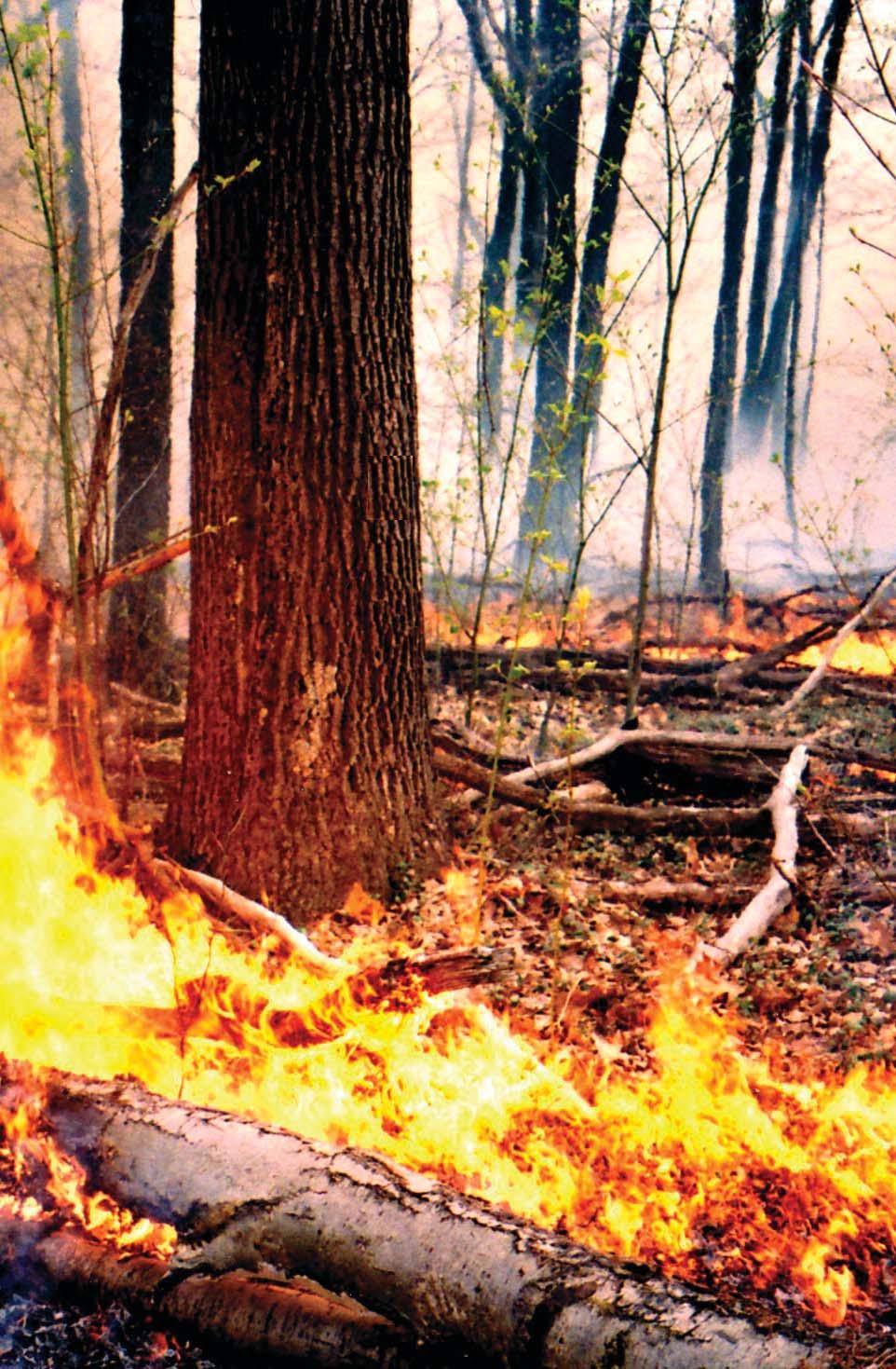
9 Stand about 20 feet away from the tree on the downhill side. Look through the guide and select a photo that closely resembles the fuels you observe. approx. 20 The photos are arranged in order of increasing total fuel loading within each risk group. Look to the lower left corner of the page for the fire risk of the tree you are rating. 5
10 Acknowledgments The Ohio Division of Natural Resources, the Pennsylvania Bureau of Forestry, and the Pennsylvania Game Commission assisted in locating the stands used in this project and conducted the prescribed fires. Special thanks are due to Wendy Andersen, Brent Carlson, Josh Hanson, Lance Meyen, Ty Ryen, and Greg Sanford for the preburn fuel sampling and postburn monitoring. Tom Waldrop s and Dan Yaussy s reviews of earlier versions of this manuscript helped with clarity and organization. This research was partially funded by the USDA Forest Service through the Joint Fire Science Program and the National Fire Plan. References Brose, P.H.; Van Lear, D.H Effects of seasonal prescribed fires on residual overstory trees in oakdominated shelterwood stands. Southern Journal of Applied Forestry. 23(3): Brose, P.H.; Schuler, T.M.; Ward, J.S Responses of oak and other hardwood regeneration to prescribed fire: what we know as of In: Dickinson, M.B., ed. Fire in eastern oak forests: delivering science to land managers. Gen. Tech. Rep. NRS-1. Newtown Square, PA: U.S. Department of Agriculture, Forest Service, Northern Research Station: Brose, P.H.; Gottschalk, K.W.; Horsley, S.B.; Knopp, P.D.; Kochenderfer, J.N.; McGuinness, B.J.; Miller, G.W.; Ristau, T.E.; Stoleson, S.H.; Stout, S.L Prescribing regeneration treatments for mixed-oak forests of the mid-atlantic region. Gen. Tech. Rep. NRS-33. Newtown Square, PA: U.S. Department of Agriculture, Forest Service, Northern Research Station: 100 p. 6
11 Brown, J.K Handbook for inventorying downed woody material. Gen. Tech. Rep. INT-16. Ogden, UT: U.S. Department of Agriculture, Forest Service, Intermountain Forest and Range Experiment Station. 24 p. Dickinson, M.B., ed Fire in eastern oak forests: delivering science to land managers. Gen. Tech. Rep. NRS-P-1. Newtown Square, PA: U.S. Department of Agriculture, Forest Service, Northern Research Station. 303 p. Fosberg, M.A Drying rates of wood below fiber saturation. Forest Science 16: Gottschalk, K.W.; MacFarlane, W.R Photographic guide to crown conditions: use for gypsy moth silvicultural treatments. Gen. Tech. Rep. NE-168. Radnor, PA: U.S. Department of Agriculture, Forest Service, Northeastern Research Station. 8 p. Hutchinson, T.F., ed. In press. Proceedings of a workshop: Fire in eastern oak forests: learning from experience. To be published as a Northern Research Station General Technical Report. Loomis, R.M Estimating firecaused mortality and injury in oak-hickory forests. Res. Pap. NC-94. St Paul, MN: U.S. Department of Agriculture, Forest Service, North Central Forest Experiment Station. 6 p. Yaussy, D.A., comp Fire, people, and the central hardwood landscape. Gen. Tech. Rep. NE-274. Newtown Square, PA: U.S. Department of Agriculture, Forest Service, Northeastern Research Station. 129 p. Yaussy, D.A.; Waldrop, T.A. in press. Delayed mortality of eastern hardwoods after prescribed fire. In: Stanturf, J.A., ed. Proceedings of the 14th biennial southern silviculture research conference. Gen. Tech. Rep. SRS-. Asheville, NC: U.S. Department of Agriculture, Forest Service, Northern Research Station. 7
12
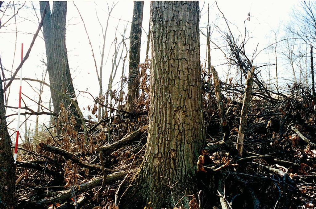
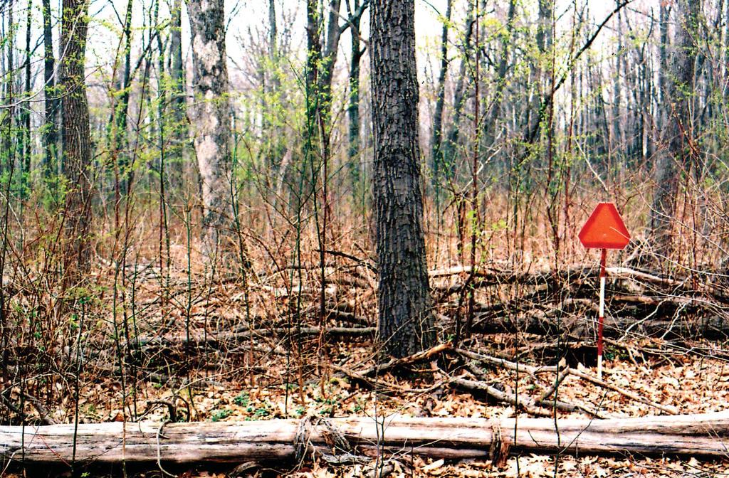
13 Trees in the low risk group exhibited no visible signs of fire damage or minor charring on a small portion of one face. Crowns were healthy and remained so during the 3 years after the fire. Most of these trees only had leaf litter (3 to 5 tons/acre) or light woody fuel loadings (7 to 11 tons/acre) near their bases. A few trees had higher woody fuel loadings (13 to 17 tons/acre) but the heat from this amount of fuel was offset by other factors such as slope, direction of fire spread, bark thickness so the trees were not injured by the fire. Low Risk 9

14
15 Photo 1: White oak (15-inch d.b.h.) Photo by Patrick Brose, U.S. Forest Service Site Characteristics Location: Vinton Furnace Experimental Forest Aspect: Southeast Vinton County, Ohio Slope: 21 % Date: March 2001 Slope Position: Upper 1/3 Fuel Conditions Litter cover: 100 % Fuel bed height: 0.3 ft. Fuel Size and Type Leaf litter 1-hour woody 10-hour woody 100-hour woody 1,000-hour woody Total fuels Loading 3.5 tons/acre 0.1 tons/acre 0.2 tons/acre 0.0 tons/acre 0.0 tons/acre 3.8 tons/acre RISK RATING: Low 11

16
17 Photo 2: Black oak (20-inch d.b.h.) Photo by Patrick Brose, U.S. Forest Service Site Characteristics Location: Zaleski State Forest, Aspect: Southwest Vinton County, Ohio Slope: 16 % Date: March 2001 Slope Position: Middle 1/3 Fuel Conditions Litter cover: 100 % Fuel bed height: 0.2 ft. Fuel Size and Type Leaf litter 1-hour woody 10-hour woody 100-hour woody 1,000-hour woody Total fuels Loading 4.3 tons/acre 0.4 tons/acre 0.5 tons/acre 0.2 tons/acre 0.0 tons/acre 5.4 tons/acre RISK RATING: Low 13

18
19 Photo 3: White oak (22-inch d.b.h.) Photo by Patrick Brose, U.S. Forest Service Site Characteristics Location: Tar Hollow State Forest, Aspect: Southwest Ross County, Ohio Slope: 21 % Date: March 2001 Slope Position: Upper 1/3 Fuel Conditions Litter cover: 100 % Fuel bed height: 0.5 ft. Fuel Size and Type Leaf litter 1-hour woody 10-hour woody 100-hour woody 1,000-hour woody Total fuels Loading 3.4 tons/acre 0.4 tons/acre 0.7 tons/acre 1.2 tons/acre 1.6 tons/acre 7.3 tons/acre RISK RATING: Low 15

20
21 Photo 4: White oak (20-inch d.b.h.) Photo by Patrick Brose, U.S. Forest Service Site Characteristics Location: Zaleski State Forest, Aspect: Southwest Vinton County, Ohio Slope: 8 % Date: March 2001 Slope Position: Middle 1/3 Fuel Conditions Litter cover: 100 % Fuel bed height: 1.0 ft. Fuel Size and Type Leaf litter 1-hour woody 10-hour woody 100-hour woody 1,000-hour woody Total fuels Loading 3.5 tons/acre 0.3 tons/acre 1.7 tons/acre 2.3 tons/acre 1.5 tons/acre 9.3 tons/acre RISK RATING: Low 17

22
23 Photo 5: Red maple (22-inch d.b.h.) Photo by Patrick Brose, U.S. Forest Service Site Characteristics Location: Moshannon State Forest, Aspect: South Clearfield County, Pennsylvania Slope: 2 % Date: May 2008 Slope Position: Middle 1/3 Fuel Conditions Litter cover: 100 % Fuel bed height: 0.2 ft. Fuel Size and Type Leaf litter 1-hour woody 10-hour woody 100-hour woody 1,000-hour woody Total fuels Loading 3.5 tons/acre 0.1 tons/acre 0.7 tons/acre 4.8 tons/acre 1.9 tons/acre 11.0 tons/acre RISK RATING: Low 19

24
25 Photo 6: Red maple (18-inch d.b.h.) Photo by Patrick Brose, U.S. Forest Service Site Characteristics Location: Moshannon State Forest, Aspect: South Clearfield County, Pennsylvania Slope: 2 % Date: May 2008 Slope Position: Middle 1/3 Fuel Conditions Litter cover: 100 % Fuel bed height: 0.2 ft. Fuel Size and Type Leaf litter 1-hour woody 10-hour woody 100-hour woody 1,000-hour woody Total fuels Loading 3.3 tons/acre 0.1 tons/acre 0.6 tons/acre 3.4 tons/acre 3.7 tons/acre 11.1 tons/acre RISK RATING: Low 21

26
27 Photo 7: White oak (22-inch d.b.h.) Photo by Patrick Brose, U.S. Forest Service Site Characteristics Location: Zaleski State Forest, Aspect: Southwest Vinton County, Ohio Slope: 10 % Date: March 2001 Slope Position: Middle 1/3 Fuel Conditions Litter cover: 100 % Fuel bed height: 1.0 ft. Fuel Size and Type Leaf litter 1-hour woody 10-hour woody 100-hour woody 1,000-hour woody Total fuels Loading 3.5 tons/acre 0.4 tons/acre 1.2 tons/acre 6.5 tons/acre 2.0 tons/acre 13.6 tons/acre RISK RATING: Low 23

28
29 Photo 8: Black oak (17-inch d.b.h.) Photo by Patrick Brose, U.S. Forest Service Site Characteristics Location: Tar Hollow State Forest, Aspect: South Ross County, Ohio Slope: 25 % Date: March 2001 Slope Position: Upper 1/3 Fuel Conditions Litter cover: 100 % Fuel bed height: 0.6 ft. Fuel Size and Type Leaf litter 1-hour woody 10-hour woody 100-hour woody 1,000-hour woody Total fuels Loading 3.9 tons/acre 0.8 tons/acre 1.3 tons/acre 5.0 tons/acre 3.4 tons/acre 14.4 tons/acre RISK RATING: Low 25

30
31 Photo 9: White oak (21-inch d.b.h.) Photo by Patrick Brose, U.S. Forest Service Site Characteristics Location: Moshannon State Forest, Aspect: South Clearfield County, Pennsylvania Slope: 2 % Date: May 2008 Slope Position: Middle 1/3 Fuel Conditions Litter cover: 100 % Fuel bed height: 0.2 ft. Fuel Size and Type Leaf litter 1-hour woody 10-hour woody 100-hour woody 1,000-hour woody Total fuels Loading 3.5 tons/acre 0.2 tons/acre 1.2 tons/acre 8.4 tons/acre 3.3 tons/acre 16.6 tons/acre RISK RATING: Low 27
32
33 The moderate risk trees had charring on one or two faces (less than half of the bole s circumference). Crowns remained healthy during the 3 years after the fire. Fuel loadings near these trees ranged from 12 to 29 tons/acre but were usually isolated to just one face. Also, the higher fuel loadings (20 to 29 tons/acre) in this group occurred in conjunction with thick-barked species such as chestnut oak (Q. montana) and white oak (Q. alba). Moderate Risk 29

34
35 Photo 10: Black oak (21-inch d.b.h.) Photo by Patrick Brose, U.S. Forest Service Site Characteristics Location: Vinton Furnace Experimental Aspect: South Forest, Vinton County, Ohio Slope: 28 % Date: March 2001 Slope Position: Upper 1/3 Fuel Conditions Litter cover: 100 % Fuel bed height: 1.5 ft. Fuel Size and Type Leaf litter 1-hour woody 10-hour woody 100-hour woody 1,000-hour woody Total fuels Loading 3.9 tons/acre 1.0 tons/acre 0.8 tons/acre 2.4 tons/acre 3.4 tons/acre 11.5 tons/acre RISK RATING: Moderate 31

36
37 Photo 11: Scarlet oak (13-inch d.b.h.) Photo by Patrick Brose, U.S. Forest Service Site Characteristics Location: Vinton Furnace Experimental Aspect: West Forest, Vinton County, Ohio Slope: 18 % Date: March 2001 Slope Position: Upper 1/3 Fuel Conditions Litter cover: 98 % Fuel bed height: 0.3 ft. Fuel Size and Type Leaf litter 1-hour woody 10-hour woody 100-hour woody 1,000-hour woody Total fuels Loading 3.8 tons/acre 0.4 tons/acre 1.9 tons/acre 4.4 tons/acre 1.3 tons/acre 11.8 tons/acre RISK RATING: Moderate 33

38
39 Photo 12: American beech (14-inch d.b.h.) Photo by Patrick Brose, U.S. Forest Service Site Characteristics Location: State Game Land 29 Aspect: South Warren County, Pennsylvania Slope: 2 % Date: April 2006 Slope Position: Upper 1/3 Fuel Conditions Litter cover: 80 % Fuel bed height: 0.7 ft. Fuel Size and Type Leaf litter 1-hour woody 10-hour woody 100-hour woody 1,000-hour woody Total fuels Loading 2.1 tons/acre 0.4 tons/acre 0.9 tons/acre 4.1 tons/acre 7.3 tons/acre 14.8 tons/acre RISK RATING: Moderate 35

40
41 Photo 13: Scarlet oak (23-inch d.b.h.) Photo by Patrick Brose, U.S. Forest Service Site Characteristics Location: Zaleski State Forest Aspect: West Vinton County, Ohio Slope: 12 % Date: March 2001 Slope Position: Middle 1/3 Fuel Conditions Litter cover: 100 % Fuel bed height: 1.3 ft. Fuel Size and Type Leaf litter 1-hour woody 10-hour woody 100-hour woody 1,000-hour woody Total fuels Loading 3.9 tons/acre 0.3 tons/acre 2.4 tons/acre 8.2 tons/acre 2.2 tons/acre 17.0 tons/acre RISK RATING: Moderate 37

42
43 Photo 14: Chestnut oak (12-inch d.b.h.) Photo by Patrick Brose, U.S. Forest Service Site Characteristics Location: Zaleski State Forest Aspect: Southwest Vinton County, Ohio Slope: 18 % Date: March 2001 Slope Position: Upper 1/3 Fuel Conditions Litter cover: 100 % Fuel bed height: 2.0 ft. Fuel Size and Type Leaf litter 1-hour woody 10-hour woody 100-hour woody 1,000-hour woody Total fuels Loading 3.7 tons/acre 0.5 tons/acre 2.3 tons/acre 6.5 tons/acre 4.4 tons/acre 17.4 tons/acre RISK RATING: Moderate 39

44
45 Photo 15: Pignut hickory (10-inch d.b.h.) Photo by Patrick Brose, U.S. Forest Service Site Characteristics Location: Zaleski State Forest Aspect: Southwest Vinton County, Ohio Slope: 15 % Date: March 2001 Slope Position: Middle 1/3 Fuel Conditions Litter cover: 95 % Fuel bed height: 0.7 ft. Fuel Size and Type Leaf litter 1-hour woody 10-hour woody 100-hour woody 1,000-hour woody Total fuels Loading 3.7 tons/acre 0.8 tons/acre 2.0 tons/acre 7.5 tons/acre 3.5 tons/acre 17.5 tons/acre RISK RATING: Moderate 41

46
47 Photo 16: Northern red oak (20-inch d.b.h.) Photo by Patrick Brose, U.S. Forest Service Site Characteristics Location: Moshannon State Forest, Aspect: Southwest Clearfield County, Pennsylvania Slope: 2 % Date: May 2008 Slope Position: Middle 1/3 Fuel Conditions Litter cover: 100 % Fuel bed height: 0.5 ft. Fuel Size and Type Leaf litter 1-hour woody 10-hour woody 100-hour woody 1,000-hour woody Total fuels Loading 3.5 tons/acre 0.2 tons/acre 0.9 tons/acre 4.5 tons/acre 8.9 tons/acre 18.0 tons/acre RISK RATING: Moderate 43

48
49 Photo 17: Northern red oak (22-inch d.b.h.) Photo by Patrick Brose, U.S. Forest Service Site Characteristics Location: Moshannon State Forest, Aspect: South Clearfield County, Pennsylvania Slope: 2 % Date: May 2008 Slope Position: Middle 1/3 Fuel Conditions Litter cover: 100 % Fuel bed height: 0.6 ft. Fuel Size and Type Leaf litter 1-hour woody 10-hour woody 100-hour woody 1,000-hour woody Total fuels Loading 3.5 tons/acre 0.3 tons/acre 1.5 tons/acre 6.9 tons/acre 7.1 tons/acre 19.3 tons/acre RISK RATING: Moderate 45

50
51 Photo 18: Chestnut oak (23-inch d.b.h.) Photo by Patrick Brose, U.S. Forest Service Site Characteristics Location: Moshannon State Forest, Aspect: South Clearfield County, Pennsylvania Slope: 2 % Date: May 2008 Slope Position: Middle 1/3 Fuel Conditions Litter cover: 100 % Fuel bed height: 0.5 ft. Fuel Size and Type Leaf litter 1-hour woody 10-hour woody 100-hour woody 1,000-hour woody Total fuels Loading 3.5 tons/acre 0.3 tons/acre 1.2 tons/acre 8.5 tons/acre 11.8 tons/acre 24.3 tons/acre RISK RATING: Moderate 47

52
53 Photo 19: Chestnut oak (16-inch d.b.h.) Photo by Patrick Brose, U.S. Forest Service Site Characteristics Location: Zaleski State Forest, Aspect: Southwest Vinton County, Ohio Slope: 15 % Date: March 2001 Slope Position: Middle 1/3 Fuel Conditions Litter cover: 100 % Fuel bed height: 3.2 ft. Fuel Size and Type Leaf litter 1-hour woody 10-hour woody 100-hour woody 1,000-hour woody Total fuels Loading 4.4 tons/acre 0.8 tons/acre 1.6 tons/acre 11.0 tons/acre 10.7 tons/acre 28.5 tons/acre RISK RATING: Moderate 49
54
55 High risk trees sustained char on at least three faces (more than 50 percent of the bole s circumference) and had fair or poor crowns, or died within 3 years of the fire. Fuel loadings near these trees ranged from 13 to 36 tons/acre and the fuel usually abutted the trees on two or more faces. Also, the lower fuel loadings (13 to 19 tons/acre) in this group occurred in conjunction with small, thin-barked species such as red maple (Acer rubrum) and scarlet oak (Q. coccinea). High Risk 51

56
57 Photo 20: Scarlet oak (10-inch d.b.h.) Photo by Patrick Brose, U.S. Forest Service Site Characteristics Location: Vinton Furnace Experimental Forest Aspect: Southwest Vinton County, Ohio Slope: 20 % Date: March 2001 Slope Position: Upper 1/3 Fuel Conditions Litter cover: 100 % Fuel bed height: 1.2 ft. Fuel Size and Type Leaf litter 1-hour woody 10-hour woody 100-hour woody 1,000-hour woody Total fuels Loading 3.5 tons/acre 0.2 tons/acre 1.7 tons/acre 5.3 tons/acre 2.6 tons/acre 13.3 tons/acre RISK RATING: High 53

58
59 Photo 21: Scarlet oak (13-inch d.b.h.) Photo by Patrick Brose, U.S. Forest Service Site Characteristics Location: Vinton Furnace Experimental Forest Aspect: Southwest Vinton County, Ohio Slope: 20 % Date: March 2001 Slope Position: Upper 1/3 Fuel Conditions Litter cover: 100 % Fuel bed height: 1.5 ft. Fuel Size and Type Leaf litter 1-hour woody 10-hour woody 100-hour woody 1,000-hour woody Total fuels Loading 4.2 tons/acre 0.4 tons/acre 1.7 tons/acre 6.1 tons/acre 3.8 tons/acre 16.2 tons/acre RISK RATING: High 55

60
61 Photo 22: Red maple (11-inch d.b.h.) Photo by Patrick Brose, U.S. Forest Service Site Characteristics Location: Moshannon State Forest, Aspect: South Clearfield County, Pennsylvania Slope: 5 % Date: May 2008 Slope Position: Middle 1/3 Fuel Conditions Litter cover: 100 % Fuel bed height: 0.8 ft. Fuel Size and Type Leaf litter 1-hour woody 10-hour woody 100-hour woody 1,000-hour woody Total fuels Loading 3.3 tons/acre 0.2 tons/acre 2.1 tons/acre 6.6 tons/acre 7.1 tons/acre 19.3 tons/acre RISK RATING: High 57

62
63 Photo 23: Northern red oak (22-inch d.b.h.) Photo by Patrick Brose, U.S. Forest Service Site Characteristics Location: Moshannon State Forest, Aspect: Northwest Clearfield County, Pennsylvania Slope: 2 % Date: May 2008 Slope Position: Middle 1/3 Fuel Conditions Litter cover: 100 % Fuel bed height: 1.2 ft. Fuel Size and Type Leaf litter 1-hour woody 10-hour woody 100-hour woody 1,000-hour woody Total fuels Loading 3.5 tons/acre 0.2 tons/acre 1.6 tons/acre 11.6 tons/acre 6.2 tons/acre 23.1 tons/acre RISK RATING: High 59

64
65 Photo 24: White oak (20-inch d.b.h.) Photo by Patrick Brose, U.S. Forest Service Site Characteristics Location: Zaleski State Forest, Aspect: Southwest Vinton County, Ohio Slope: 16 % Date: March 2001 Slope Position: Middle 1/3 Fuel Conditions Litter cover: 100 % Fuel bed height: 1.5 ft. Fuel Size and Type Leaf litter 1-hour woody 10-hour woody 100-hour woody 1,000-hour woody Total fuels Loading 3.6 tons/acre 0.3 tons/acre 1.3 tons/acre 11.6 tons/acre 6.9 tons/acre 23.7 tons/acre RISK RATING: High 61

66
67 Photo 25: White oak (14-inch d.b.h.) Photo by Patrick Brose, U.S. Forest Service Site Characteristics Location: Zaleski State Forest, Aspect: Southwest Vinton County, Ohio Slope: 11 % Date: March 2001 Slope Position: Middle 1/3 Fuel Conditions Litter cover: 100 % Fuel bed height: 3.5 ft. Fuel Size and Type Leaf litter 1-hour woody 10-hour woody 100-hour woody 1,000-hour woody Total fuels Loading 3.9 tons/acre 0.7 tons/acre 3.6 tons/acre 12.1 tons/acre 3.9 tons/acre 24.2 tons/acre RISK RATING: High 63

68
69 Photo 26: Red maple (14-inch d.b.h.) Photo by Patrick Brose, U.S. Forest Service Site Characteristics Location: State Game Land 29, Aspect: South Warren County, Pennsylvania Slope: 2 % Date: April 2006 Slope Position: Upper 1/3 Fuel Conditions Litter cover: 100 % Fuel bed height: 1.3 ft. Fuel Size and Type Leaf litter 1-hour woody 10-hour woody 100-hour woody 1,000-hour woody Total fuels Loading 3.3 tons/acre 0.6 tons/acre 1.1 tons/acre 9.5 tons/acre 14.6 tons/acre 26.1 tons/acre RISK RATING: High 65

70
71 Photo 27: Northern red oak (15-inch d.b.h.) Photo by Patrick Brose, U.S. Forest Service Site Characteristics Location: Moshannon State Forest, Aspect: South Clearfield County, Pennsylvania Slope: 2 % Date: May 2008 Slope Position: Middle 1/3 Fuel Conditions Litter cover: 100 % Fuel bed height: 0.7 ft. Fuel Size and Type Leaf litter 1-hour woody 10-hour woody 100-hour woody 1,000-hour woody Total fuels Loading 3.4 tons/acre 0.3 tons/acre 2.0 tons/acre 13.5 tons/acre 7.7 tons/acre 26.9 tons/acre RISK RATING: High 67

72
73 Photo 28: Pignut hickory (7-inch d.b.h.) Photo by Patrick Brose, U.S. Forest Service Site Characteristics Location: Tar Hollow State Forest, Aspect: South Ross County, Ohio Slope: 30 % Date: March 2001 Slope Position: Middle 1/3 Fuel Conditions Litter cover: 100 % Fuel bed height: 2.1 ft. Fuel Size and Type Leaf litter 1-hour woody 10-hour woody 100-hour woody 1,000-hour woody Total fuels Loading 3.1 tons/acre 0.3 tons/acre 2.9 tons/acre 11.5 tons/acre 9.2 tons/acre 27.0 tons/acre RISK RATING: High 69
74
75 Photo 29: Chestnut oak (24-inch d.b.h.) Photo by Patrick Brose, U.S. Forest Service Site Characteristics Location: Vinton Furnace Experimental Forest, Aspect: Northeast Vinton County, Ohio Slope: 33 % Date: March 2001 Slope Position: Upper 1/3 Fuel Conditions Litter cover: 100 % Fuel bed height: 3.3 ft. Fuel Size and Type Leaf litter 1-hour woody 10-hour woody 100-hour woody 1,000-hour woody Total fuels Loading 4.0 tons/acre 0.2 tons/acre 1.2 tons/acre 18.5 tons/acre 10.5 tons/acre 34.1 tons/acre RISK RATING: High 71

76
77 Photo 30: Northern red oak (24-inch d.b.h.) Photo by Patrick Brose, U.S. Forest Service Site Characteristics Location: Moshannon State Forest, Aspect: South Clearfield County, Pennsylvania Slope: 2 % Date: May 2008 Slope Position: Middle 1/3 Fuel Conditions Litter cover: 90 % Fuel bed height: 0.6 ft. Fuel Size and Type Leaf litter 1-hour woody 10-hour woody 100-hour woody 1,000-hour woody Total fuels Loading 3.4 tons/acre 0.1 tons/acre 1.0 tons/acre 6.3 tons/acre 25.7 tons/acre 36.5 tons/acre RISK RATING: High 73
78
79 Extreme risk trees died during the first postfire growing season. Fuel loadings ranged from 19 to 50 tons/acre near their bases and fuel arrangement was often on all sides of the trees. Because of these loadings and the resultant sustained intense heat during the prescribed burn, no species was impervious, regardless of bark thickness. Extreme Risk 75

80
81 Photo 31: Red maple (6-inch d.b.h.) Photo by Patrick Brose, U.S. Forest Service Site Characteristics Location: Tar Hollow State Forest, Aspect: Southeast Ross County, Ohio Slope: 23 % Date: March 2001 Slope Position: Middle 1/3 Fuel Conditions Litter cover: 100 % Fuel bed height: 1.5 ft. Fuel Size and Type Leaf litter 1-hour woody 10-hour woody 100-hour woody 1,000-hour woody Total fuels Loading 2.1 tons/acre 0.6 tons/acre 2.0 tons/acre 9.3 tons/acre 5.2 tons/acre 19.2 tons/acre RISK RATING: Extreme 77

82
83 Photo 32: Pignut hickory (7-inch d.b.h.) Photo by Patrick Brose, U.S. Forest Service Site Characteristics Location: Vinton Furnace Experimental Forest, Aspect: South Vinton County, Ohio Slope: 28 % Date: March 2001 Slope Position: Upper 1/3 Fuel Conditions Litter cover: 100 % Fuel bed height: 4.5 ft. Fuel Size and Type Leaf litter 1-hour woody 10-hour woody 100-hour woody 1,000-hour woody Total fuels Loading 3.5 tons/acre 0.3 tons/acre 1.0 tons/acre 14.4 tons/acre 7.4 tons/acre 26.6 tons/acre RISK RATING: Extreme 79

84
85 Photo 33: Northern red oak (15-inch d.b.h.) Photo by Patrick Brose, U.S. Forest Service Site Characteristics Location: Moshannon State Forest, Aspect: South Clearfield County, Pennsylvania Slope: 2 % Date: May 2008 Slope Position: Middle 1/3 Fuel Conditions Litter cover: 80 % Fuel bed height: 1.4 ft. Fuel Size and Type Leaf litter 1-hour woody 10-hour woody 100-hour woody 1,000-hour woody Total fuels Loading 3.3 tons/acre 0.2 tons/acre 1.8 tons/acre 7.7 tons/acre 20.1 tons/acre 33.1 tons/acre RISK RATING: Extreme 81
86
87 Photo 34: Northern red oak (15-inch d.b.h.) Photo by Patrick Brose, U.S. Forest Service Site Characteristics Location: Moshannon State Forest, Aspect: South Clearfield County, Pennsylvania Slope: 2 % Date: May 2008 Slope Position: Middle 1/3 Fuel Conditions Litter cover: 80 % Fuel bed height: 1.4 ft. Fuel Size and Type Leaf litter 1-hour woody 10-hour woody 100-hour woody 1,000-hour woody Total fuels Loading 2.8 tons/acre 0.1 tons/acre 0.9 tons/acre 9.0 tons/acre 26.5 tons/acre 39.3 tons/acre RISK RATING: Extreme 83

88
89 Photo 35: Chestnut oak (16-inch d.b.h.) Photo by Patrick Brose, U.S. Forest Service Site Characteristics Location: Moshannon State Forest, Aspect: South Clearfield County, Pennsylvania Slope: 2 % Date: May 2008 Slope Position: Middle 1/3 Fuel Conditions Litter cover: 100 % Fuel bed height: 1.1 ft. Fuel Size and Type Leaf litter 1-hour woody 10-hour woody 100-hour woody 1,000-hour woody Total fuels Loading 3.5 tons/acre 0.2 tons/acre 1.3 tons/acre 6.9 tons/acre 28.3 tons/acre 40.2 tons/acre RISK RATING: Extreme 85

90
91 Photo 36: Red maple (11-inch d.b.h.) Photo by Patrick Brose, U.S. Forest Service Site Characteristics Location: Moshannon State Forest, Aspect: South Clearfield County, Pennsylvania Slope: 2 % Date: May 2008 Slope Position: Middle 1/3 Fuel Conditions Litter cover: 100 % Fuel bed height: 1.8 ft. Fuel Size and Type Leaf litter 1-hour woody 10-hour woody 100-hour woody 1,000-hour woody Total fuels Loading 3.4 tons/acre 0.3 tons/acre 1.5 tons/acre 18.8 tons/acre 16.8 tons/acre 40.8 tons/acre RISK RATING: Extreme 87

92
93 Photo 37: Northern red oak (12-inch d.b.h.) Photo by Patrick Brose, U.S. Forest Service Site Characteristics Location: Moshannon State Forest, Aspect: South Clearfield County, Pennsylvania Slope: 2 % Date: May 2008 Slope Position: Middle 1/3 Fuel Conditions Litter cover: 100 % Fuel bed height: 2.1 ft. Fuel Size and Type Leaf litter 1-hour woody 10-hour woody 100-hour woody 1,000-hour woody Total fuels Loading 3.5 tons/acre 0.2 tons/acre 1.5 tons/acre 12.1 tons/acre 25.2 tons/acre 42.5 tons/acre RISK RATING: Extreme 89

94
95 Photo 38: Black oak (21-inch d.b.h.) Photo by Patrick Brose, U.S. Forest Service Site Characteristics Location: Tar Hollow State Forest, Aspect: South Ross County, Ohio Slope: 30 % Date: March 2001 Slope Position: Middle 1/3 Fuel Conditions Litter cover: 100 % Fuel bed height: 4.0 ft. Fuel Size and Type Leaf litter 1-hour woody 10-hour woody 100-hour woody 1,000-hour woody Total fuels Loading 4.5 tons/acre 0.8 tons/acre 2.9 tons/acre 18.9 tons/acre 18.6 tons/acre 45.7 tons/acre RISK RATING: Extreme 91

96
97 Photo 39: Northern red oak (22-inch d.b.h.) Photo by Patrick Brose, U.S. Forest Service Site Characteristics Location: State Game Land 29, Aspect: South Warren County, Pennsylvania Slope: 2 % Date: April 2006 Slope Position: Upper 1/3 Fuel Conditions Litter cover: 85 % Fuel bed height: 2.5 ft. Fuel Size and Type Leaf litter 1-hour woody 10-hour woody 100-hour woody 1,000-hour woody Total fuels Loading 2.9 tons/acre 0.5 tons/acre 1.8 tons/acre 13.4 tons/acre 27.6 tons/acre 46.2 tons/acre RISK RATING: Extreme 93

98
99 Photo 40: Scarlet oak (24-inch d.b.h.) Photo by Patrick Brose, U.S. Forest Service Site Characteristics Location: Zaleski State Forest, Aspect: West Vinton County, Ohio Slope: 10 % Date: March 2001 Slope Position: Middle 1/3 Fuel Conditions Litter cover: 100 % Fuel bed height: 4.2 ft. Fuel Size and Type Leaf litter 1-hour woody 10-hour woody 100-hour woody 1,000-hour woody Total fuels Loading 4.0 tons/acre 1.4 tons/acre 3.2 tons/acre 23.4 tons/acre 18.3 tons/acre 50.3 tons/acre RISK RATING: Extreme 95
100 NOTES
101
102 Brose, Patrick H Photo guide for estimating risk to hardwood trees during prescribed burning operations in eastern oak forests. Gen. Tech. Rep. NRS-44. Newtown Square, PA: U.S. Department of Agriculture, Forest Service, Northern Research Station. 95 p. A field guide of 40 photographs of common hardwood trees of eastern oak forests and fuel loadings surrounding their bases. The guide contains instructions on how to rapidly assess a tree s likelihood to be damaged or killed by prescribed burning. KEY WORDS: forest fire, forest fuels, Quercus, shelterwood system
103 The U.S. Department of Agriculture (USDA) prohibits discrimination in all its programs and activities on the basis of race, color, national origin, age, disability, and where applicable, sex, marital status, familial status, parental status, religion, sexual orientation, genetic information, political beliefs, reprisal, or because all or part of an individual s income is derived from any public assistance program. (Not all prohibited bases apply to all programs.) Persons with disabilities who require alternate means for communication of program information (Braille, large print, audiotape, etc.) should contact USDA s TARGET Center at (202) (voice and TDD). To file a complaint of discrimination, write to USDA, Director, Office of Civil Rights, 1400 Independence Avenue, S.W., Washington, DC , or call (800) (voice) or (202) (TDD). USDA is an equal opportunity provider and employer. March 2009
104 Capitalizing on the strengths of existing science capacity in the Northeast and Midwest to attain a more integrated, cohesive, landscape-scale research program
Tree Survival 15 Years after the Ice Storm of January 1998
 United States Department of Agriculture Tree Survival 15 Years after the Ice Storm of January 1998 Walter C. Shortle Kevin T. Smith Kenneth R. Dudzik Forest Service Northern Research Paper Research Station
Regeneration of Upper-Elevation Red Oak in the White Mountains of New Hampshire
 United States Department of Agriculture Forest Service Northern Research Station Research Note NRS-161 Regeneration of Upper-Elevation Red Oak in the White Mountains of New Hampshire William B. Leak Mariko
Simulating Regeneration Dynamics in Upland Oak Stands
 Simulating Regeneration Dynamics in Upland Oak Stands Powered By Powered by: USDA Forest Service Southern Research Station Dr. David Loftis Powered By Powered by: Regen for Excel is a simulation model
Georgia, Forest Inventory & Analysis Factsheet. Richard A. Harper. Timberland Area and Live-Tree Volume by Survey
 Georgia, 211 Richard A. Harper Forest Inventory & Analysis Factsheet F I A Forest cover along the Ocmulgee River south of Macon, GA. (photo courtesy of the Georgia Forestry Commission) 3 25 2 15 1 5 Area
Texas, Forest Inventory & Analysis Factsheet. James W. Bentley. Forested Area. Introduction. Inventory Volume
 Texas, 21 James W. Bentley Forest Inventory & Analysis Factsheet F I A The Nation s Forest Census Introduction Guadalupe River State Park, Comel County, TX. (photo by This science update summarizes the
Dominant-Tree Thinning in New England Northern Hardwoods a Second Look
 United States Department of Agriculture Dominant-Tree Thinning in New England Northern Hardwoods a Second Look William B. Leak Forest Service Northern Research Note Research Station NRS-201 September 2015
North Carolina, 2010
 North Carolina, Introduction Mark J. Brown and Barry D. New North Carolina s first annualized forest survey was completed in and results were published in e-science Update SRS 029. There were 5,800 ground
Evaluating the Management Potential of Upland Hardwood Stands
 DIVISION OF AGRICULTURE RESEARCH & EXTENSION University of Arkansas System Agriculture and Natural Resources FSA5012 Evaluating the Management Potential of Upland Hardwood Stands Kyle Cunningham Extension
EVOLUTION OF A MEETING: 20+ YEARS OF RESEARCH COMMUNICATION AND COORDINATION
 EVOLUTION OF A MEETING: 20+ YEARS OF RESEARCH COMMUNICATION AND COORDINATION Michael L. McManus 1 (retired) and Kurt W. Gottschalk 2 1 USDA Forest Service, Northern Research Station, Hamden CT 06514 2
Janice K. Wiedenbeck and Thomas M. Schuler 1
 Effects of Prescribed Fire on the Wood Quality and Marketability of Four Hardwood Species in the Central Appalachian Region Janice K. Wiedenbeck and Thomas M. Schuler 1 Abstract. A series of research studies
Colorado Front Range Fuel Photo Series
 Colorado Front Range Fuel Photo Series Michael A. Battaglia Jonathan M. Dodson Wayne D. Shepperd Mark J. Platten Owen M. Tallmadge General Technical Report RMRS-GTR-1WWW United States Department of Agriculture
Frequently Asked Questions. Adapted from the on-line Teachers Guide
 Frequently Asked Questions Adapted from the on-line Teachers Guide http://mff.dsisd.net 1 2 Frequently Asked Questions About Michigan s Forest 1. Is Michigan running out of trees or forest? No. Forest
Softwood Lumber Prices for Evaluation of Small-Diameter Timber Stands in the Intermountain West
 United States Department of Agriculture Forest Service Forest Products Laboratory Research Note FPL RN 0270 Softwood Lumber Prices for Evaluation of Small-Diameter Timber Stands in the Intermountain West
Stonewall Vegetation Project FEIS Errata
 United States Department of Agriculture Stonewall Vegetation Project FEIS Errata Forest Service Helena National Forest 1 Lincoln Ranger District April 2015 These following missing items or edits are errata
Christopher M. Oswalt Forest Inventory & Analysis Factsheet
 United States Department of Agriculture Christopher M. Oswalt Forest Inventory & Analysis Factsheet Cumberland Falls. (photo by Chris Kuehl, Wikimedia.org) This science update provides an overview of forest
Soybean Objective Yield Survey Data,
 Washington, D.C. Soybean Objective Yield Survey Data, 1992-2006 Released July 27, 2007, by the National Agricultural Statistics Service (NASS),, U.S. Department of Agriculture. For information on call
Corn Objective Yield Survey Data,
 Washington, D.C. Corn Objective Yield Survey Data, 1992-2006 Released May 18, 2007, by the National Agricultural Statistics Service (NASS),, U.S. Department of Agriculture. For information on call Ty Kalaus
Forest Resources of the Black Hills National Forest
 United States Department of Agriculture Forest Service Rocky Mountain Research Station August 22 Forest Resources of the Black Hills National Forest Larry T. DeBlander About the author Larry T. DeBlander
Engineering Watershed, Soil, & Air
 Engineering Watershed, Soil, & Air United States Department of Agriculture Forest Service Technology & Development Program December 2008 2500/7100 0871 2346 MTDC Using Scarification, Wood Shreddings, and
Structural Changes in the Growing Stock of Important Tree Species Groups in the Central. Hardwood Region. William G. Luppold and Matthew S.
 1 Structural Changes in the Growing Stock of Important Tree Species Groups in the Central Hardwood Region William G. Luppold and Matthew S. Bumgardner Affiliations: William G. Luppold (wluppold@fs.fed.us),
Huron-Manistee National Forests Mio Ranger District 107 McKinley Road Mio, MI 48647
 United States Department of Agriculture Forest Service Huron-Manistee National Forests Mio Ranger District 107 McKinley Road Mio, MI 48647 989-826-3252 (Voice) 989-826-6073 (Fax) Dial 711 for relay service
THE ROLE OF BIOCONTROL OF EMERALD ASH BORER
 FHAAST-2017-02 November 2017 THE ROLE OF BIOCONTROL OF EMERALD ASH BORER IN PROTECTING ASH REGENERATION AFTER INVASION Jian J. Duan1 Roy G. Van Driesche2 Leah S. Bauer3 Richard Reardon4 Juli Gould5 Joseph
Bulletin of Hardwood Market Statistics: 2005
 United States Department of Agriculture Forest Service Northeastern Research Station Bulletin of Hardwood Market Statistics: 2005 Research Note NE-387 Melody Akers Abstract Provides current and historical
2012 Maple Cultivar Winter Damage Assessment. North Dakota Forest Service
 North Dakota Forest Service 2012 Maple Cultivar Winter Damage Assessment An assessment was carried out in July 2012 to estimate the extent of damage to Autumn Blaze Maple (Acer x freemanii Jeffersfred
Telegraph Forest Management Project
 Telegraph Forest Management Project Black Hills National Forest Northern Hills Ranger District Lawrence and Pennington Counties, South Dakota Proposed Action and Request for Comments March 2008 Table of
Factors Affecting Oxidative Stain in Soft Maple (Acer rubrum L.)
") United States Department of Agriculture Forest Service Forest Products Laboratory Research Note FPL RN 0311 Factors Affecting Oxidative Stain in Soft Maple (Acer rubrum L.) Michael C. Wiemann Mark Knaebe
United States Department of Agriculture Forest Service Forest Products Laboratory Research Note FPL RN 0311 Factors Affecting Oxidative Stain in Soft Maple (Acer rubrum L.) Michael C. Wiemann Mark Knaebe
Wheat Objective Yield Survey Data,
 Washington, D.C. Wheat Objective Yield Survey Data, 1993-2007 Released May 30, 2008, by the National Agricultural Statistics Service (NASS),, U.S. Department of Agriculture. For information on call Todd
Proposed Action. for the. North 40 Scrub Management Project
 United States Department of Agriculture Forest Service Proposed Action for the North 40 Scrub Management Project National Forests in Florida, Ocala National Forest February 2016 For More Information Contact:
Cheat Mountain Wildlife Habitat Enhancement
 United States Department of Agriculture Forest Service Monongahela National Forest Greenbrier Ranger District Box 67 Bartow, WV 24920 304-456-3335 File Code: 2670/1950 Date: June 7, 2011 Scoping - Opportunity
Vestal Project Proposed Action Hell Canyon Ranger District Black Hills National Forest April 2011
 Vestal Project Proposed Action Hell Canyon Ranger District Black Hills National Forest April 2011 Introduction: The Vestal Project area is located surrounding the city of Custer, South Dakota within Custer
2016 Urban Forest Analysis within Three Parks in Burlington, Vermont
 2016 Urban Forest Analysis within Three Parks in Burlington, Vermont John Truong Forest Ecosystem Monitoring Cooperative (formerly Vermont Monitoring Cooperative) 5/25/2017 1 Contents Executive Summary...
Slash mats (figure 1) are used to help reduce impacts
 are used to help reduce impacts") Fire United States Department of Agriculture Forest Service Technology & Development Program May 2008 5100 0851 2312 MTDC Removing Slash Mats James Scott Groenier, Project Leader Slash mats (figure 1)
Fire United States Department of Agriculture Forest Service Technology & Development Program May 2008 5100 0851 2312 MTDC Removing Slash Mats James Scott Groenier, Project Leader Slash mats (figure 1)
DECISION MEMO MANHATTAN FUELS REDUCTION PROJECT U.S. FOREST SERVICE CANYON LAKES RANGER DISTRICT LARIMER COUNTY, CO
 DECISION MEMO MANHATTAN FUELS REDUCTION PROJECT U.S. FOREST SERVICE CANYON LAKES RANGER DISTRICT LARIMER COUNTY, CO Background and Project Description In order to improve forest health and reduce hazardous
Stand Development and Yields o Appalachian Hardwood Stands Managed with Single-Tree Selection for at Least 30 Years
 el%+ United States epartment of w 4 Agriculture @D Forest Service I Northeastern Forest Experiment Station Research Paper NE-655 Stand Development and Yields o Appalachian Hardwood Stands Managed with
Financial Analysis of Fuel Treatments on National Forests in the Western United States
 United States Department of Agriculture Forest Service Pacific Northwest Research Station Research Note PNW-RN-555 Financial Analysis of Fuel Treatments on National Forests in the Western United States
PROJECT INFORMATION Manchester Ranger District Apple Tree Release and Maintenance Project
 PROJECT INFORMATION Manchester Ranger District Apple Tree Release and Maintenance Project The USDA Forest Service is proposing to release and prune living apple trees in the Manchester Ranger District,
Hassayampa Landscape Restoration Environmental Assessment
 Hassayampa Landscape Restoration Environmental Assessment Economics Report Prepared by: Ben De Blois Forestry Implementation Supervisory Program Manager Prescott National Forest for: Bradshaw Ranger District
TRENDS IN DELAWARE S FORESTS
 United States Department of Agriculture TRENDS IN DELAWARE S FORESTS Forest Service Northeastern Research Station NE-INF-150-02 Delaware Department of Agriculture Forest Service DELAWARE FORESTS Forests
General Location: Approximately 6 miles east of Huntsville, Utah along the South Fork of the Ogden River (Figure 1)
") PUBLIC SCOPING SOUTH FORK WUI OGDEN RANGER DISTRICT, UINTA-WASATCH-CACHE NATIONAL FOREST WEBER COUNTY, UTAH OCTOBER 6, 2017 1.0 INTRODUCTION The Ogden Ranger District of the Uinta-Wasatch-Cache National
PUBLIC SCOPING SOUTH FORK WUI OGDEN RANGER DISTRICT, UINTA-WASATCH-CACHE NATIONAL FOREST WEBER COUNTY, UTAH OCTOBER 6, 2017 1.0 INTRODUCTION The Ogden Ranger District of the Uinta-Wasatch-Cache National
NTRAL HARDWOOD NOTES. Thinning Even-Aged, Upland Oak Stands
 North Central Forest Experiment Station 6.06 NTRAL HARDWOOD NOTES Thinning Even-Aged, Upland Oak Stands Thinning produces bigger and better trees faster. Thinning removes poor quality trees and concentrates
Lake Fire Restoration and Hazardous Tree Removal. Project Proposed Action and Scoping Document
 United States Department of Agriculture Forest Service November 2016 Lake Fire Restoration and Hazardous Tree Removal Heather McRae Project Proposed Action and Scoping Document USDA Forest Service Shasta-Trinity
Users Guide for Noble Fir Bough Cruiser
 United States Department of Agriculture Forest Service Pacific Northwest Research Station General Technical Report PNW-GTR-644 July 2005 Users Guide for Noble Fir Bough Cruiser Roger D. Fight, Keith A.
The Wildland Fire Chemical
 United States Department of Agriculture Forest Service Technology & Development Program Airtanker 157-287-MTDC January 21 51/57 Drop Guides Ground Pattern Performance of the California Department of Forestry
Mountain pine beetle attack in ponderosa pine: Comparing methods for rating susceptibility
 United States Department of Agriculture Forest Service Rocky Mountain Research Station Research Paper RMRS RP 26 September 2000 Mountain pine beetle attack in ponderosa pine: Comparing methods for rating
NE-TWIGS Update: Incorporating Tree Quality
 SOFTWARE NE-TWIGS Update: Incorporating Tree Quality By Daniel A. Yaussy ABSTRACT Amethodto distribute tree quality was incorporated into the NE-TWIGS individual-tree growth and yield simulator. The programuses
A Comparison of Two Stem Injection Treatments Applied to American Beech in Central West Virginia
 United States Department of Agriculture Forest Service Northern Research Station Research Paper NRS-21 A Comparison of Two Stem Injection Treatments Applied to American Beech in Central West Virginia Jeffrey
Airtanker. Drop Guides. Ground Pattern Performance of the Neptune P2V-7 Airtanker Paul Solarz, Program Leader, and Cammie Jordan, Project Assistant
 United States Department of Agriculture Forest Service Technology & Development Program Airtanker 57-2848-MTDC September 2 51/57 Drop Guides Ground Pattern Performance of the Neptune P2V-7 Airtanker Paul
Forest biomass by component for the coterminous United States Forest Products Society International Convention June 20, 2010 Madison, WI Pat Miles
 Forest biomass by component for the coterminous United States Forest Products Society International Convention June 20, 2010 Madison, WI Pat Miles Outline 1. FIA sample design 2. Biomass components pre-aug
Role of Woody Species in (Riparian) Buffer Plantings
 Buffer Plantings") Role of Woody Species in (Riparian) Buffer Plantings Ginger Kopp State Staff Forester USDA NRCS, St. Paul MN April 1, 2008 USDA is an equal opportunity provider and employer. NRCS Conservation Practice
Role of Woody Species in (Riparian) Buffer Plantings Ginger Kopp State Staff Forester USDA NRCS, St. Paul MN April 1, 2008 USDA is an equal opportunity provider and employer. NRCS Conservation Practice
Non-Ambulatory Cattle and Calves
 Washington, D.C. Non-Ambulatory Cattle and Calves Released May 5, 2005, by the National Agricultural Statistics Service (NASS),, U.S. Department of Agriculture. For information on Non-ambulatory Cattle
DECISION MEMO SFA EXPERIMENTAL FOREST HERBACEOUS POND RESTORATION AUGUST, 2009 ANGELINA/SABINE RANGER DISTRICT ANGELINA NATIONAL FOREST
 402 C B B DECISION MEMO SFA EXPERIMENTAL FOREST HERBACEOUS POND RESTORATION AUGUST, 2009 ANGELINA/SABINE RANGER DISTRICT ANGELINA NATIONAL FOREST NACOGDOCHES COUNTY, TEXAS USDA FOREST SERVICE, REGION 8
The Influence of Species on Site Selection and Timber Removal in West Virginia. William Luppold 1 and Delton Alderman 2 USDA Forest Service
 The Influence of Species on Site Selection and Timber Removal in West Virginia William Luppold 1 and Delton Alderman 2 USDA Forest Service 1 Project Leader, USDA Forest Service, Northeastern Research Station,
NTRALHARDWOOD NOTES. Estimating Oak Growth and Yield. Managed Stand Yield. Individual Tree Growth and Yield Models
 North Central Forest Experiment Station 5.03 NTRALHARDWOOD NOTES Estimating Oak Growth and Yield Yields from upland oak stands vary widely from stand to stand due to differences in age, site quality, species
DECISION MEMO. Wildlife Habitat Improvement Project Wildlife Opening Construction, Rehabilitation and Expansion FY
 DECISION MEMO Wildlife Habitat Improvement Project Wildlife Opening Construction, Rehabilitation and Expansion FY 2007-2013 USDA Forest Service Bankhead National Forest - National Forests in Alabama Winston
Oaks (Quercus spp.) are one of the most important tree species in the
 are one of the most important tree species in the") The Effects of Canopy Density and Vegetative Competition on Oak Seedling Numbers in Southeastern Ohio Stephen Rist Spring 2006 Abstract The regeneration of oak species in the forest setting has been a
The Effects of Canopy Density and Vegetative Competition on Oak Seedling Numbers in Southeastern Ohio Stephen Rist Spring 2006 Abstract The regeneration of oak species in the forest setting has been a
Basics of the Oak Shelterwood Method
 Basics of the Oak Shelterwood Method Jeff Stringer Professor, Hardwood Silviculture and Forest Operations Department of Forestry University of Kentucky David Loftis Forest Ecologist USFS Southern Station
Two-Age System. and Deferment Harvests
 Extension Two-Age System and Deferment Harvests Jeff Stringer, Extension Professor of Hardwood Silviculture, Department of Forestry, University of Kentucky SP679 The two-age system is designed to maintain
OAK WILT FUNGUS. Kate Berven FES 557
 & OAK WILT FUNGUS Kate Berven FES 557 Historical significance Oak today Adaptations Disease complex biology and life cycle Strategies Health Management Plan Lumber industry relies heavily upon Represents
A Method For Determining Stand Relative Density And Using The Information To Prescribe A Thinning For Even-aged Northern Hardwoods In New York State
 A Method For Determining Stand Relative Density And Using The Information To Prescribe A Thinning For Even-aged Northern Hardwoods In New York State Ralph D. Nyland Distinguished Service Professor Emeritus
Proposed Action for 30-day Notice and Comment Emerald Ash Borer SLow Ash Mortality (SLAM) Hoosier National Forest Brownstown Ranger District
 Hoosier National Forest Brownstown Ranger District") United States Department of Agriculture Forest Service February 2012 Proposed Action for 30-day Notice and Comment 2012 Emerald Ash Borer SLow Ash Mortality (SLAM) Hoosier National Forest Brownstown Ranger
United States Department of Agriculture Forest Service February 2012 Proposed Action for 30-day Notice and Comment 2012 Emerald Ash Borer SLow Ash Mortality (SLAM) Hoosier National Forest Brownstown Ranger
NTRAL HARDWOOD NOTES. Estimating Pine Growth And Yield
 North Central Forest Experiment Station 5.08 NTRAL HARDWOOD NOTES Estimating Pine Growth And Yield Although hardwoods comprise the bulk of the volume in the central hardwood forest, pines are locally important
Measuring Tree Seedlings and Associated Understory Vegetation in Pennsylvania s Forests. Methods
 Measuring Tree Seedlings and Associated Understory Vegetation in Pennsylvania s Forests William H. McWilliams 1,Todd W. Bowersox 2,Patrick H. Brose 3, Daniel A. Devlin 4,James C. Finley 2,Kurt W. Gottschalk
NRCS Water Quality Practices
 NRCS Water Quality Practices Presented by: Ruth Book, P.E., Ph.D. State Conservation Engineer Champaign, Illinois www.il.nrcs.usda.gov 2016 Illinois Water Conference October 27, 2016 Agenda Working with
Recruitment of Shortleaf Pine into the Upper Canopy of Mixed Species Even Aged Forest in Southeast Missouri Ozarks
 Quantitative Silviculture Laboratory, 2013 Recruitment of Shortleaf Pine into the Upper Canopy of Mixed Species Even Aged Forest in Southeast Missouri Ozarks David M. McCorkell, Lance A. Vickers, and David
U.S. Forest Facts and Historical Trends
 Errata In the printed version of this brochure the graphics on page 13 should be in Billion cubic feet. The following pdf version of the brochure has been corrected. U.S. Forest Facts and Historical Trends
New Turf for Gypsy Moth; There's More at Risk Downrange
 United States Department of Agriculture Forest Service Nottheastern Forest Experiment Station Research Paper NE-519 1983 New Turf for Gypsy Moth; There's More at Risk Downrange David A. Gansner, Owen W.
Locally Led Conservation & The Local Work Group. Mark Habiger NRCS
 Locally Led Conservation & The Local Work Group Mark Habiger NRCS 1 What Is Locally Led Conservation? Community Stakeholders 1. Assessing their natural resource conservation needs 2. Setting community
Forest Resources of the Lolo National Forest
 United States Department of Agriculture Forest Service Rocky Mountain Research Station June 2000 Forest Resources of the Lolo National Forest Larry T. DeBlander About the author Larry T. DeBlander is a
2017 Regional Envirothon
 2017 Regional Envirothon Forestry Test (25 Points Total) MATCHING: Match the term to the description that best fits (1 Point Each) A. Selective Harvest B. Baltimore Stick C. Clinometer D. Prism E. High
Airtanker. Drop Guides
 United States Department of Agriculture Forest Service Technology & Development Program Airtanker 57-282-MTDC May 51/57 Drop Guides Ground Pattern Performance of the SEI Industries Bambi 324- Gallon Helibucket
Harvest, Employment, Exports, and Prices in Pacific Northwest Forests,
 Pacific Northwest Research Station Harvest, Employment, Exports, and Prices in Pacific Northwest Forests, 1965 2000 General Technical Report PNW-GTR-547 July 2002 Debra D. Warren United States Department
Effect of Cattle Grazing, Seeded Grass, and an Herbicide on Ponderosa Pine Seedling Survival and Growth
 United States Department of Agriculture Forest Service Pacific Southwest Research Station http://www.psw.fs.fed.us/ Research Paper PSW-RP-242 Effect of Cattle Grazing, Seeded Grass, and an Herbicide on
All Mushroom Sales Virtually Unchanged, Value Down 1 Percent
 Washington, D.C. Released August 6, 005, by the National Agricultural Statistics Service (NASS),, U.S. Department Agriculture. For information on call Debbie Flippin at (0) 70-350, fice hours 7:30 a.m.
Carson National Forest El Rito Ranger District El Rito, New Mexico Outreach Response due by close of business on March 26, 2013.
 Carson National Forest El Rito, New Mexico Outreach Response due by close of business on March 26, 2013. Outreach Notice: Forestry Technician Silviculture Technician (GS-0462-05/06/07) This notification
Sparta Vegetation Management Project
 Sparta Vegetation Management Project Social and Economics Report Prepared by: John Jesenko Presale/Forest Measurements Specialist /s/ John Jesenko for: Whitman Ranger District Wallowa-Whitman National
Quality Response of Even-Aged 80-Year-Old White Oak Trees ter Thinning
 Forest Service Northeastern Forest Experiment Station Research Paper N E-543 Quality Response of Even-Aged 80-Year-Old White Oak Trees ter Thinning David L. Sonderman Abstract Stem defects were studied
Short Form Botany Resource Reports:
 United States Department of Agriculture Forest Service December 2014 Short Form Botany Resource Reports: 1) Botany Resource Report 2) Biological Assessment for Threatened, Endangered, Proposed Species
Forest Glen Recreation Residence Septic System Improvements Soils Report Shasta-Trinity National Forest January 2011
 Terrain Background: Soil map units: Forest Glen Recreation Residence Septic System Improvements Soils Report Shasta-Trinity National Forest January 2011 32 Deadwood very gravelly loam, 40 to 60% slopes
Bob Beckley Project Leader
 Bob Beckley Project Leader USDA Forest Service Technology and Development Program Missoula, MT 2E22A64 Crosscut Saw Sharpening Tools First printed June 2005 Revised March 2012 The Forest Service, United
Decision Memo Raptor 1 and 9 Prescribed Burns Project
 Decision Memo Raptor 1 and 9 Prescribed Burns Project USDA Forest Service Chemult Ranger District, Fremont-Winema National Forests Klamath County, OR Township (T) 29 South (S), Range (R) 6 East (E), Section
Porcupine Vegetation and Road Management Project - Shasta Salamander Report - June 23, 2011
 The following summary includes the best available science for Shasta salamander (Hydromantes shastae, HYSH) in regards to its range and habitat to determine whether a project would trigger the need for
Botany Resource Reports:
 United States Department of Agriculture Forest Service December 2014 Botany Resource Reports: 1) Botany Resource Report 2) Biological Assessment for Threatened, Endangered, Proposed Species 3) Biological
Introduction. Plot Methods
 54.06% of trees healthy in the 3800 foot elevation plot. The percentage of standing dead trees was also higher at the highest elevation plot, where 43.3% of trees were standing dead, compared with 8.0%
 BEATONS LAKE TIMBER SALE Highlights Watersmeet Ranger District OTTAWA NATIONAL FOREST The Beatons Lake Timber Sale Area is located 10 miles west of Watersmeet, Michigan, and 1 mile north on Gogebic County
Mob Grazing vs. Tight Grazing vs. Low Utilization
 Mob Grazing vs. Tight Grazing vs. Low Utilization Karen Hoffman Resource Conservationist Animal Science USDA-NRCS Norwich, NY Slide 1 Who Is This Man? Slide 2 Definitions Many definitions are used for
National Soil Health Initiative
 National Soil Health Initiative Ensuring Sustainable Agriculture for the Future USDA is an equal opportunity provider and employer. Words from Former NRCS Chief Dave White soil is one of our most important
Tree Risk Assessment: Executive Summary
 Tree Risk Assessment: Executive Summary Prepared For: Randy Lawrence Public Works Director Nichols Hills Public Works (405) 843-5222 RLAWRENCE@NICHOILSHILLS.NET Prepared By: Mark Bays Riley Coy Urban Forestry
DECISION MEMO. Griz Thin (Stand )
") Background DECISION MEMO Griz Thin (Stand 507089) USDA Forest Service Siuslaw National Forest Central Coast Ranger District Lane County, Oregon Township 16 South, Range 10 West, Sections 6 and 7 The Cummins-Tenmile
Background DECISION MEMO Griz Thin (Stand 507089) USDA Forest Service Siuslaw National Forest Central Coast Ranger District Lane County, Oregon Township 16 South, Range 10 West, Sections 6 and 7 The Cummins-Tenmile
Final Decision Memo. Murphy Meadow Restoration Project. USDA Forest Service Willamette National Forest McKenzie River Ranger District
 Final Decision Memo Murphy Meadow Restoration Project USDA Forest Service Willamette National Forest McKenzie River Ranger District T19S, R5E, Sec. 23, 24. Lane County Oregon BACKGROUND The Murphy Meadow
Overview. United States Department of Agriculture. Sampling error (percent) Sampling error (percent)
 Sampling error (percent)") United States Department of Agriculture This resource update provides an overview of forest resources in Nebraska based on inventories conducted by the USDA Forest Service, Forest Inventory and Analysis
United States Department of Agriculture This resource update provides an overview of forest resources in Nebraska based on inventories conducted by the USDA Forest Service, Forest Inventory and Analysis
DECISION MEMO JASON MINE-BAT HABITAT IMPROVEMENT AND MINE CLOSURE Section 22, T. 13S., R. 2W. Union County, Illinois
 DECISION MEMO JASON MINE-BAT HABITAT IMPROVEMENT AND MINE CLOSURE Section 22, T. 13S., R. 2W. Union County, Illinois USDA Forest Service Mississippi Bluffs Ranger District, Shawnee National Forest Background
A Crown Cover Chart For Oak Savannas
 March, 1994, TB-NC-2 A Crown Cover Chart For Oak Savannas Jay R. Law, USDA Forest Service (retired) Paul S. Johnson, Principal Silviculturist Garry Houf, Forest Biologist, Mark Twain National Forest Although
CORN BEST MANAGEMENT PRACTICES APPENDIX A. Corn Planting Guide
 CORN BEST MANAGEMENT PRACTICES APPENDIX A Corn Planting Guide Obtaining maximum profit from a corn crop depends on the timely planting of an appropriate hybrid, at the proper depth, with a planter that
Environmental Assessment for Jackson Thinning
 United States Department of Agriculture Forest Service Pacific Northwest Region Environmental Assessment for Jackson Thinning Olympic National Forest January 2008 Mt. Walker, 1928 The U.S. Department of
Decision Memo Tongass National Forest. Wrangell Ranger District. Pre-Commercial Thinning CE 2010
 Decision Memo Tongass National Forest Pre-Commercial Thinning CE 2010 Decision It is my decision to authorize pre-commercial thinning (PCT) on approximately 7,500 acres of overstocked young-growth forest
Forest Resources of the Ashley National Forest
 United States Department of Agriculture Forest Service Intermountain Research Station December 1997 Forest Resources of the Ashley National Forest Renee A. O Brien Ronald P. Tymcio This summary of the
STUMP SPROUT DOMINANCE PROBABILITIES OF FIVE OAK SPECIES IN SOUTHERN INDIANA 20 YEARS AFTER CLEARCUT HARVESTING
 STUMP SPROUT DOMINANCE PROBABILITIES OF FIVE OAK SPECIES IN SOUTHERN INDIANA 20 YEARS AFTER CLEARCUT HARVESTING Dale R. Weigel, Daniel C. Dey, and Chao-Ying Joanne Peng 1 Abstract. Oak (Quercus spp.) stump
Weaving Knowledge. How traditional and scientific knowledge can contribute to management of good beargrass harvesting sites for basketry
 The Forest Service of the U.S. Department of Agriculture is dedicated to the principle of multiple use management of the Nation s forest resources for sustained yields of wood, water, forage, wildlife,
Woodland Planning for Success
 Woodland Planning for Success Why Do I Need a Forest Management Plan? 20 th Annual Tri-State Forest Stewardship Conference 2014 Wade Conn Natural Resources Conservation Service State Forester Champaign,
BANDIT TIMBER SALE Highlights Iron River Ranger District OTTAWA NATIONAL FOREST The Bandit Timber Sale Area is along the south side of FR 3110, 2.1 mi
 BANDIT TIMBER SALE Highlights Iron River Ranger District OTTAWA NATIONAL FOREST The Bandit Timber Sale Area is along the south side of FR 3110, 2.1 miles south of Iron County Highway 436 (Smokey Lake Road),