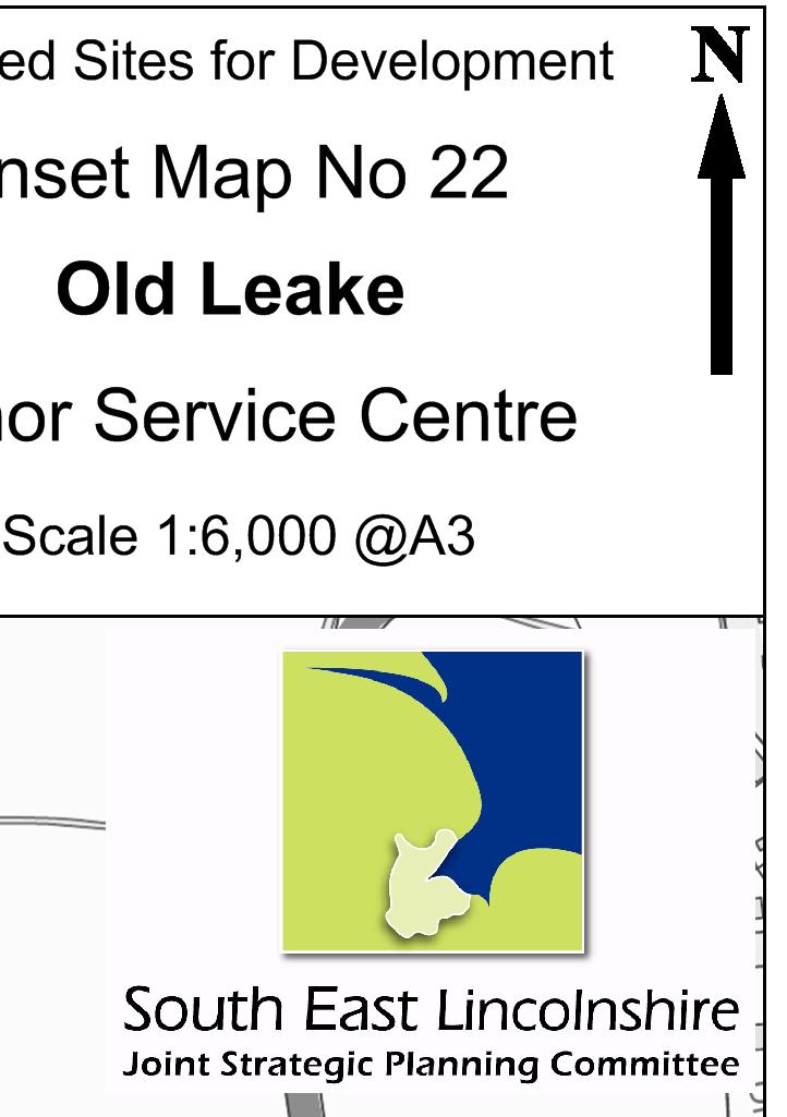
SOUTH EAST LINCOLNSHIRE LOCAL PLAN: HOUSING PAPER OLD LEAKE (JUNE 2016)
|
|
|
- Daisy Jessica Harper
- 6 years ago
- Views:
Transcription
1 SOUTH EAST LINCOLNSHIRE LOCAL PLAN: HOUSING PAPER OLD LEAKE (JUNE 2016) 1 OLD LEAKE S PLACE IN THE SPATIAL STRATEGY 1.1 Policy 2 of the South East Lincolnshire Local Plan Draft for Public Consultation (January 2016) identified Old Leake as a Minor Service Centre. 1.2 Comments received The following comment was received concerning Old Leake s place in the Spatial Strategy: 1. suggest further consideration of Old Leake as a Main Service Centre. There appears to be a deficiency to the north east of Boston. Old Leake is unusual in having secondary education in a village context and there is employment and other services. Development here could help to support other villages to the north and east of Boston. 1.3 Response to the above comment: 1. Old Leake s place in the Plan s Spatial Strategy took account of many issues, including: the findings of the South East Lincolnshire Assessment of Settlements & their Sustainability Credentials (June 2015); the population of the parish; the local rate of housing growth between 1976 and 2011; and the local availability of land at lower risk of flooding. Whilst it is correct that Old Leake offers secondary education (as well as primary education and a Health Centre), its Sustainability of Settlement score amounted to 67, which is considerably lower than the score of any of the Main Service Centres (the lowest score for which was 79). It is not therefore accepted that Old Leake performs a sufficiently significant service role to justify its identification as a Main Service Centre. 1.4 Conclusions on Old Leake s place in the Spatial Strategy It is not considered that the consultee s comment justifies a change to Old Leake s place in the Spatial Strategy. Consequently, it is considered that Old Leake should remain as a Minor Service Centre. 2 OLD LEAKE S HOUSING REQUIREMENTS 2.1 Policy 12 of the South East Lincolnshire Local Plan Draft for Public Consultation (January 2016) identified that housing allocations should be made in Old Leake to provide for 100 dwellings between 1 st April 2011 and 31 st March Comments received The following comments were received concerning Old Leake s housing requirements:
2 1. the employment and services at Old Leake could justify a higher level of development. Old Leake is unusual in having secondary education in a village context and there is employment and other services. Development here could help to support other villages to the north and east of Boston; and 2. the Parish Council recognises and appreciates the requirements of Policy for villages to grow and expand to meet housing needs, and does not oppose the total number of houses which the Plan seeks to provide. 100 houses over the next Plan Period would not be unreasonable and out of proportion with the village as it currently is. 2.3 Responses to the above comments: 1. the scale of housing growth proposed for Old Leake took account of many issues, including: the findings of the South East Lincolnshire Assessment of Settlements & their Sustainability Credential (June 2015); the population of the parish; the local rate of housing growth between 1976 and 2011; and the local availability of land at lower risk of flooding. Whilst it is correct that Old Leake offers secondary education and limited employment opportunities (as well as some other services) its Sustainability of Settlement score does not suggest that it performs a sufficiently significant service role to justify an increase to its housing requirements; and 2. the support is welcomed. 2.4 Conclusions on Old Leake s housing requirements - It is not considered that the comments justify a change to Old Leake s housing requirements, and consequently, it is considered that the Local Plan should continue to seek to identify housing allocations in Old Leake to provide for 100 dwellings between 1 st April 2011 and 31 st March OLD LEAKE S RESIDUAL REQUIREMENTS 3.1 Completions - Between 1 st April 2011 and 31 st March 2016, 35 new dwellings were built in Old Leake. 3.2 Commitments - As at 31 st March 2016, planning permission was outstanding for the development of 36 dwellings in Old Leake, and there is no evidence to suggest that these permissions will not be implemented during the Plan period. 3.3 Residual requirement - Given the above figures, the identification of land to accommodate approximately 29 dwellings is required. ( = 29).
3 4 INFRASTRUCTURE 4.1 Education the County Education Department has commented that there is some capacity at primary and secondary level to cope with the proposed scale of development. 4.2 Flood risk the Environment Agency has made the following comments: Allocations in areas of hazard would need to ensure that finished floor levels (FFL) are raised to the appropriate level with additional flood resilient construction incorporated into proposals. Developers would need to confirm that they can achieve the required mitigation and that their proposals would still be deliverable. o o o Flood Risk Mitigation Policy to ensure 'safe' development. Requirements for FFL: depths of >1.6m It is unlikely that mitigation measures would prevent flood waters from entering the building at ground floor level. Therefore, proposals must be a minimum 2 storey with no ground floor habitable accommodation. The first floor living accommodation shall be above the highest predicted flood depth. depths of 1-1.6m Proposals must be a minimum 2 storey, with FFL set a minimum of 1m above ground level, flood resilient construction shall be used to a height 300mm above predicted flood level, demountable defences to 600mm above FFL; depths 0.5 1m FFL to be set 1m above ground level, flood resilient construction shall be used to a height 300mm above the predicted flood level, (single storey proposals must consider the 0.1%+ climate change event for setting FFL). 4.3 Anglian Water has commented that the capacity of the surface water network has major constraints, and that all developments should seek to reduce flood risk and incorporate Sustainable Drainage Systems (SuDS). They indicate that surface water may not be discharged to the public foul sewerage network, and that no new surface water flow will be permitted to discharge to the combined network. 4.4 Sewage Treatment the Environment Agency has commented that Old Leake Water Recycling Centre (Sewage Treatment Works) has capacity for 690 houses. Anglian Water has commented that the Water Recycling Centre has capacity available to serve the proposed growth, and that the foul sewerage network also has capacity to accommodate the sites. 4.5 Water Supply Anglian Water has commented that, whilst water resources are adequate to serve the proposed growth, upgrades to the supply network may be required to serve the sites. 4.6 Health The CCGs have commented that currently there is some capacity at the local GP surgeries to accommodate additional patients, however County wide there is an increasing shortage of GPs, nurses and other healthcare staff which could affect future capacity should demand increase.
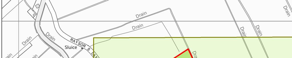
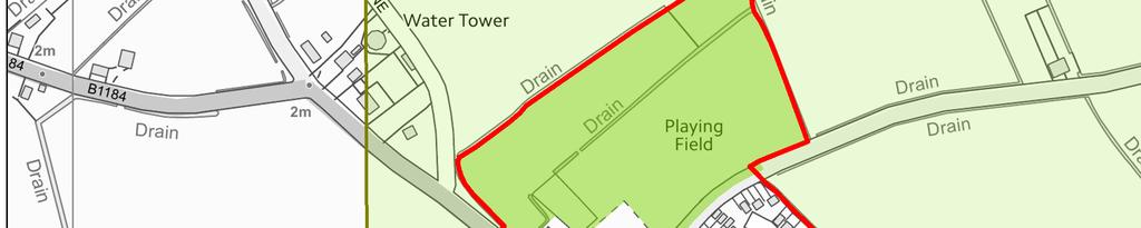
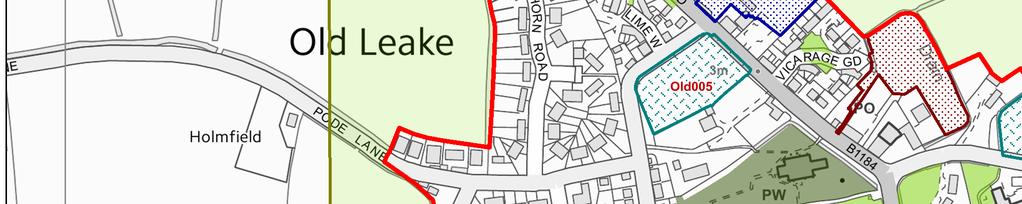
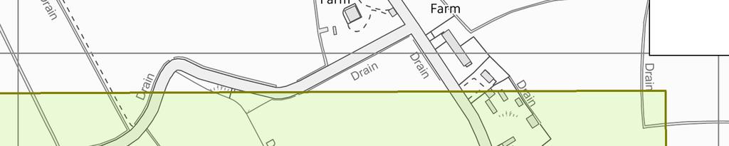
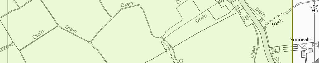
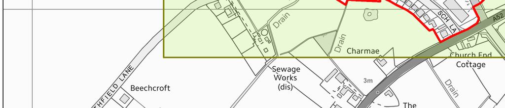
4 5 OLD LEAKE SITE OPTIONS 5.1 Inset Map 23 of the South East Lincolnshire Local Plan Draft for Public Consultation (January 2016) identified four Potential Housing Sites, Old001, Old003, Old005, and Old Comments received The following general comment was made: 1. I am not opposed to sensible housing development in Old Leake but the sewerage system is currently undersized and overworked. Ingress of surface water overwhelms the capacity of the system, which results in surcharging occurring at the foul water drain manhole located in Summerfields and possibly at other locations. It is possible that the existing water treatment plant might be able to deal with the amount of effluent but the pipe system cannot. Other utilities would also be put under strain and would need extending, putting a financial burden on the utilities suppliers with small return on investment as the majority of return would be domestic with very small industrial input. The flood risk is also too high to be reasonable (refer to the declaration in your literature). 5.3 Response to the above comment: 1. Anglian Water Services Ltd. has identified no issues with respect to the area s foul sewerage network capacity. The need for any enhancement to other utilities will be identified by the Infrastructure Delivery Plan that will accompany the Local Plan. The flood risk to which the sites are exposed varies but, as the comments in paragraph 4.2 of this paper shows, flood risk mitigation to ensure 'safe' development is possible. 5.4 Conclusions on general comment It is not considered that the comment justifies a change to the Plan s provisions Comments received - The following comments were made on site Old001 (Land to the south of Old Main Road, Old Leake): 1. The sewage pipe in Old Main Road, Old Leake, which also serves Wrangle is old and inadequate. If there is a problem on the Wrangle side or Church Road in Old Leake, the foul water backs up to Summerfields, which is unacceptable. The sewage network would need to be upgraded to cope with the extra developments on the Old Main Road;
5 2. Anglian Water identifies that surface water drainage has major constraints. The properties in Summerfields have soak-aways, which do not cope with heavy rain and most winters gardens are underwater. We are on clay and in our paddock blue clay. It has had drains put in but still the soak-aways flood with the surface water. Anglian Water must make sure the surface water network can cope with extra water from the new developments; 3. The Parish Council supports site Old001 unequivocally; 4. Development here will potentially be an eyesore; 5. Because new homes will be raised above existing ground level (to mitigate flood risk) they will overlook existing neighbouring dwellings; 6. New homes will increase the risk of flooding to existing neighbouring dwellings; 7. Existing infrastructure (schools and the medical centre) will be unable to accommodate additional demand; and 8. Increased traffic on Old Main Road and the A52 will cause problems. 5.6 Response to the above comments: 1. Anglian Water Services Ltd. has identified no issues with respect to this site s impacts upon the area s foul sewerage network capacity; 2. Anglian Water Services Ltd. has identified issues with the surface water network capacity, and seeks any development to incorporate sustainable drainage systems and to adhere to the surface water management hierarchy outlined in Part H of the Building Regulations. However, such issues are not unique to site Old001 they apply equally to all alternative sites elsewhere in Old Leake, and indeed throughout the Plan area; 3. The support is welcomed; 4. The Strategic Housing Land Availability Assessment concludes that the site could be developed without adverse impacts on the character or appearance of the area; 5. Issues of potential overlooking are not particular to this site, and would be addressed at planning application stage; 6. Anglian Water Services Ltd. has indicated that new development would need to incorporate sustainable drainage systems, which are intended to replicate natural systems (to collect and store surface water before slowly releasing it back into the environment) and prevent surface water impacting on neighbouring land;
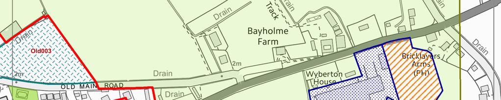
6 7. The need for any enhancement to the schools and medical centre will be identified by the Infrastructure Delivery Plan that will accompany the Local Plan; and 8. The Highway Authority has identified no issues arising from the development of this site. 5.7 Conclusions on site Old001 It is considered that, site Old001 is not one of the more suitable Potential Housing Sites in Old Leake, and that it should not be taken forward as a Preferred Housing Site: although the site attracted objections, none of the issues raised appear to be insoluble, or are particular to this site; however the Sustainability Appraisal does not score site Old001 particularly well, with only one positive (green) impact (for sustainability objective 1) and two negative (red) impacts being recorded (for sustainability objectives 2 and 9); and the site is at more severe flood risk ( flood zone 3a, danger for all, and 1.0m-2.0m ) than one of the alternative Potential Housing Sites in Old Leake Comments received - The following comments were made on site Old003 (Land to the north of Old Main Road, Old Leake): 1. The site owner argues that, although it is not in the middle of the village, the site is nonetheless close to the village s amenities, and does not encroach too far out of the village. This site would be quieter than those which are adjacent to the A52. The site has recently been under-drained; 2. This land is prone to flooding, and Anglian Water s requirement that surface water may not be discharged to the public sewerage network will make matters worse. Existing properties opposite the site suffer from problems with lying water; 3. At school times the whole area is grid locked by on-street parking which severely restricts road width (the road is used by buses and HGVs). The addition of more dwellings in this area will make matters worse; 4. This site has considerable amenity value, with its frontage hedgerow and trees and is the last remaining ancient pasture in the village. DEFRA would be very unlikely to grant the farmer permission to plough this field and turn it into arable cultivation, but to develop this field for housing would amount to a far greater and more permanent destruction than planting potatoes or wheat. It is unlikely that this field has ever been cultivated in modern times; and
7 5. The sewage pipe in Old Main Road, Old Leake, which also serves Wrangle is old and inadequate. If there is a problem on the Wrangle side or Church Road in Old Leake, the foul water backs up to Summerfields, which is unacceptable. The sewage network would need to be upgraded to cope with the extra developments on the old Main Road. 5.9 Responses to the above comments: 1. The support is welcomed; 2. Anglian Water Services Ltd. has identified issues with the surface water network capacity, and seeks any development to incorporate sustainable drainage systems and to adhere to the surface water management hierarchy outlined in Part H of the Building Regulations. The idea of sustainable drainage systems is to replicate natural systems to collect and store surface water before slowly releasing it back into the environment (i.e. to prevent the issues being experienced by the properties opposite the site). However, such issues are not unique to site Old003 they apply equally to all alternative sites elsewhere in Old Leake, and indeed throughout the Plan area; 3. The Highway Authority has not raised any concerns about the traffic implications of the development of site Old003; 4. The Strategic Housing Land Availability Assessment acknowledges that the site contributes significantly to the attractive appearance of this part of the village, and that its development would inevitably change this character. However, it concludes that the site's relationship to the existing village is good, and that its impacts upon the character and appearance of the area would be broadly acceptable; and 5. Anglian Water Services Ltd. has identified no issues with respect to this site s impacts upon the area s foul sewerage network capacity 5.10 Conclusions on site Old003 it is considered that site Old003 is one of the more suitable Potential Housing Sites in Old Leake, and that it should be taken forward as a Preferred Housing Site: the site is at more severe flood risk ( flood zone 3a, danger for all, and 1.0m-2.0m ) than one of the alternative Potential Housing Sites in Old Leake; however although the site attracted objections, none of the issues raised appear to be insoluble, or are particular to this site; and the Sustainability Appraisal scores site Old003 relatively well, with two positive (green) impacts (for sustainability objectives 1 and 8) and only one negative (red) impact being recorded.
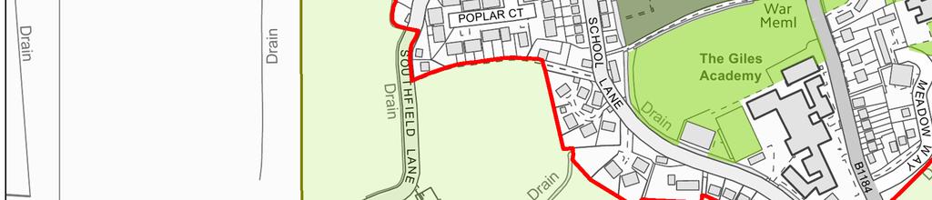
8 Comments received - The following comments were made on site Old005 (Land to the south and east of School Lane, Old Leake): 1. Historic England indicates that this site may affect the setting of the Grade I listed Church of St Mary. Concern is raised at the inclusion of this site, which has remained open within the centre of the village and detailed further assessment would be required; and 2. The Parish Council unanimously and resolutely opposes site Old005. This site has been protected in the previous Local Plan as a Protected Open Space, and is greatly valued by both the Council and the local community as the last remaining open space in a village which has seen every other field or farm close to the centre developed over recent years. The site was protected in the 1990s to prevent intensive overdevelopment of the village centre and, if anything, with the loss of open space nearby, those reasons are now reinforced Responses to the above comments: 1. The site is located some 60m from the curtilage to the listed church, and it is not considered that it forms a substantive part of the listed building s setting. The Borough Council s Consultant Architect comments that the site is in the centre of the village but is separated from the church by the two residential sites of the Old Vicarage and the Grange. Provided the hedged tree lined boundaries between the church and The Vicarage and The Grange remain, some development on the site... could be considered provided this was a low density scheme and one which retained some form of green at its centre to maintain a village-like character. Traditional materials would be required and the majority should be two-storey development. Consequently, it is not accepted that this site is unsuitable for development in principle, although the Consultant Architect s comments mean that the capacity of the site will need to be reconsidered; and
9 2. The Parish Council is correct that this site was identified as a Protected Landscape Site in the adopted Boston Borough Local Plan (April 1999), and as Protected Land of Open Character in the Boston Borough Interim Plan (February 2006). The adopted Plan identified that such an open space was an important component in the overall character of the settlement, whilst the Interim Plan identified the following roles: provide an attractive setting for the settlement; provide a setting for listed or other important historical buildings; provide a setting for important historical or natural features; frame or enable an important view; provide an important amenity element in a street scene; or provide visual relief in an otherwise built up frontage. It is not accepted that any of the above roles applies to this site, and the Strategic Housing Land Availability Assessment identifies that it has only limited amenity value and that its contribution to the character of its surroundings is relatively limited Conclusions on site Old005 it is considered that site Old005 is one of the more suitable Potential Housing Sites in Old Leake, and that it should be taken forward as a Preferred Housing Site (although its assumed capacity should be reduced to 10 to take account of the need for a low density scheme with some form of green at its centre): the Sustainability Appraisal scores site Old005 relatively well, with 2 positive (green) impacts (for sustainability objectives 1 and 8) and only one negative (red) impact being recorded; the site is at the least severe flood risk of any of the Potential Housing Sites in Old Leake ( flood zone 3a, danger for most, and 0.5m-1.0m ); and the concerns about the site s impacts upon the nearby listed church and upon the village s character generally are not shared Comments received - The following comment was made on site Old008 (Land to the south of Meadow Way, Old Leake): 1. The Parish Council supports site Old008 unequivocally Response to the above comment: 1. The support is welcomed Conclusions on site Old008 - It is considered that site Old008 is not one of the more suitable Potential Housing Sites in Old Leake, and that it should not be taken forward as a Preferred Housing Site: the site attracted no objections; however
10 the Sustainability Appraisal gives site Old008 the worst score of all the Potential Housing Sites in Old Leake, with only one positive (green) impact (for sustainability objective 1) and three negative (red) impacts being recorded (for sustainability objectives 2, 8 and 9); the site is at more severe flood risk ( flood zone 3a, danger for all, and 1.0m-2.0m ) than one of the alternative Potential Housing Sites in Old Leake; and with the development of a CO-OP store (ref B/14/0435), it appears that approximately one-third of the site is no longer available for residential development, and that opportunities for vehicular access to come from Meadow Way may have been extinguished NEW SITES 6.1 One new site was put forward for consideration as a Potential Housing Site: Old017 - Land to the east of Vicarage Gardens, Old Leake. The SHLAA identifies this site as being undevelopable because of transport issues - the only potential current vehicular access is via a drive off Vicarage Gardens which the Highway Authority identifies as unsuitable to accommodate the traffic generated by this site. The site's owner suggests that it could also be accessed from the east, via the site for which a residential planning permission has been granted. However, this permission (B/13/0308) does not provide for vehicular access to this land. 7 PREFERRED HOUSING SITES AND TRAJECTORY 7.1 The following sites are taken forward as Preferred Housing Sites: Old003 and Old005. These sites have a capacity of 48 dwellings, which exceeds the residual requirement of 29 dwellings. 7.2 These allocations provide the following trajectory for Old Leake. [N.B. The capacity of site Old003 assumes that it will be developed at a density of 20 dwellings to the hectare. In practice, it may be developed at a higher density. The capacity of site Old005 assumes that it will be developed at a density of 15 dwellings to the hectare to take account of the need for a low density scheme with some form of green at its centre. It is unlikely that a greater number of dwellings would be appropriate.]
11 Years Years Years Years Years Years TOTAL Completions Commitments Old Old TOTAL


12
BUT001: Land to the east of Benington Road, Butterwick Sustainability Objective
 BUT001: Land to the east of Benington Road, Butterwick Sustainability Objective 1. Provide a miture of sustainably designed new housing to provide everybody in South East Lincolnshire with the opportunity
Almeley Neighbourhood Development Plan (2011 to 2031)
") Almeley Neighbourhood Development Plan (2011 to 2031) CONSULTATION: DRAFT VISION & OBJECTIVES WHAT IS THE ALMELEY NEIGHBOURHOOD DEVELOPMENT PLAN? Neighbourhood Development Plans (NDPs) contain planning
Almeley Neighbourhood Development Plan (2011 to 2031) CONSULTATION: DRAFT VISION & OBJECTIVES WHAT IS THE ALMELEY NEIGHBOURHOOD DEVELOPMENT PLAN? Neighbourhood Development Plans (NDPs) contain planning
FIS001: Land to the east of Lindis Road, Boston Sustainability Objective
 FIS001: Land to the east of Lindis Road, Boston Sustainability Objective Indicative development scenario: Total site area: 7.46ha Potential open space: 0.75ha Development area: 6.71ha Potential no of dwellings:
MOU001: Land to the west of Eaugate Road, Moulton Chapel Sustainability Objective
 MOU001: Land to the west of Eaugate Road, Moulton Chapel Sustainability Objective Indicative development scenario: Total site area: 0.24ha Potential open space: 0.03ha Development area: 0.21ha Potential
Maidstone Borough Council Draft Local Plan February 2016 Local Plan Regulation 19 Representation from Helen Whately MP
 Maidstone Borough Council Draft Local Plan February 2016 Local Plan Regulation 19 Representation from Helen Whately MP 1. Introduction 1.1. I have read the Maidstone Borough Council (MBC) draft Local Plan
GC001: Lambert s Transport/Europa Tyres, Station Road, Gosberton Risegate
 GC001: Lambert s Transport/Europa Tyres, Station Road, Gosberton Risegate Sustainability Objective 1. To provide a mix of sustainably designed new housing to provide everybody in South East Lincolnshire
Appendix B. Chesterfield Borough Council Local Plan. Sustainability Appraisal of Gypsy and Traveller Site Options
 Appendix B Chesterfield Borough Council Local Plan Sustainability Appraisal of Gypsy and Traveller Site Options Non-Technical Summary NTS1 Purpose of this report This document is the Non-Technical Summary
an Inspector appointed by the Secretary of State for Communities and Local Government
 Appeal Decision Site visit made on 15 November 2017 by A A Phillips BA (Hons) DipTP MTP MRTPI an Inspector appointed by the Secretary of State for Communities and Local Government Decision date: 23 November
UTT/17/2961/FUL (CLAVERING) (Called in by Cllr Oliver due to impact to highway safety and traffic generation)
 (Called in by Cllr Oliver due to impact to highway safety and traffic generation)") UTT/17/2961/FUL (CLAVERING) (Called in by Cllr Oliver due to impact to highway safety and traffic generation) PROPOSAL: LOCATION: APPLICANT: AGENT: Section 73A application for retrospective planning permission
UTT/17/2961/FUL (CLAVERING) (Called in by Cllr Oliver due to impact to highway safety and traffic generation) PROPOSAL: LOCATION: APPLICANT: AGENT: Section 73A application for retrospective planning permission
North Northamptonshire Joint Core Strategy Examination
 North Northamptonshire Joint Core Strategy Examination Joint Position and Delivery Statement By North Northamptonshire Joint Planning Unit, Kettering Borough Council And Persimmon Homes Midlands Policy
Habitats Regula ons Assessment. Border Group Neighbourhood Area Addendum
 Habitats Regula ons Assessment Border Group Neighbourhood Area Addendum November 2016 Contents 1.0 Introduction 1 2.0 Screening of proposed modifications to the NDP 1 3.0 Summary of main findings 1 4.0
28 JULY 2015 PLANNING COMMITTEE. 5i 14/1315 Reg d: Expires: Ward: OW. of Weeks on Cttee Day:
 5i 14/1315 Reg d: 25.11.2014 Expires: 29.04.15 Ward: OW Nei. Con. Exp: 14.01.15 BVPI Target Minor (13) Number of Weeks on Cttee Day: 21/8 On Target? No LOCATION: PROPOSAL: TYPE: London House, 134 High
Site Assessment Technical Document
 Central Bedfordshire Council www.centralbedfordshire.gov.uk Site Assessment Technical Document July 2017 1.1.11-1 - ii Table of Contents 1) Introduction... 7 1.1 What is the Site Assessment Technical Document?...
D12 LAND DRAINAGE, WATER CONSERVATION, FOUL DRAINAGE AND SEWAGE DISPOSAL AN INTEGRATED WATER STRATEGY
 D12 LAND DRAINAGE, WATER CONSERVATION, FOUL DRAINAGE AND SEWAGE DISPOSAL AN INTEGRATED WATER STRATEGY OBJECTIVES D12/a To ensure that the development would not be at risk of flooding either from itself
an Inspector appointed by the Secretary of State for Communities and Local Government
 Appeal Decision Site visit made on 15 December 2017 by S M Holden BSc MSc CEng MICE TPP FCIHT MRTPI an Inspector appointed by the Secretary of State for Communities and Local Government Decision date:
SOUTH CAMBRIDGESHIRE DISTRICT COUNCIL. Development and Conservation Control Committee Director of Development Services
 SOUTH CAMBRIDGESHIRE DISTRICT COUNCIL REPORT TO: AUTHOR/S: Development and Conservation Control Committee Director of Development Services 7 th July 2004 S/0574/04/F Heydon Erection of House and Garage
MIXED ACTIVITY ZONE. Chapter 4. Mixed Activity Zone
 Chapter 4 Mixed Activity Zone 4. MIXED ACTIVITY ZONE 4.1 RESOURCE MANAGEMENT ISSUES 1. Activities adjoining main arterial roads can adversely affect the safety, sustainability and efficiency of the network.
A Rail Freight Interchange for Spalding
 A Rail Freight Interchange for Spalding Consultation by South Holland District Council on a proposed development site option for a Rail Freight Interchange facility March 2010 About the proposals Introduction
Pre-Development Enquiry Form
 Pre-Development This application form is to be used to assess if we are able to provide your development with water and/or drainage services for a planned development. It is expected that this is submitted
an Inspector appointed by the Secretary of State for Communities and Local Government
 Appeal Decision Site visit made on 20 September 2016 by John Dowsett MA DipURP DipUD MRTPI an Inspector appointed by the Secretary of State for Communities and Local Government Decision date: 7 th November
Date: 14 December Uttlesford Local Plan Regulation 18 Draft Plan Consultation Responses. Report Author: Summary
 Committee: Title: Report Author: Planning Policy Working Group Uttlesford Local Plan Regulation 18 Draft Plan Consultation Responses Stephen Miles, Planning Policy Team Leader Date: 14 December 2017 Item
NORTH WESSEX DOWNS AONB POSITION STATEMENT RENEWABLE ENERGY
 NORTH WESSEX DOWNS AONB POSITION STATEMENT RENEWABLE ENERGY October 2012 1 NORTH WESSEX DOWNS AONB POSITION STATEMENT RENEWABLE ENERGY October 2012 Position Statement Status The purpose behind this Position
Detailed Methodology for More Detailed Assessment for Housing Sites. Establishing what capacity re-assessment is required
 B1.5.3 Detailed Methodology for More Detailed Assessment for Housing Sites Paragraphs 4.31 to 4.33 and 4.78 of the SSM advises that further indicative capacity work will be undertaken on each site identified
10.1 OBJECTIVES. Note: Refer to Section 6 for Issues, Methods of Implementation, and Environmental Results Anticipated.
 SECTION 10 : RURAL SETTLEMENTS Note: Refer to Section 6 for Issues, Methods of Implementation, and Environmental Results Anticipated. 10.1 OBJECTIVES The objectives contained in this section are specific
And a request for a separate additional policy relating to wastewater infrastructure.
 PLUMPTON PARISH DRAFT NEIGHBOURHOOD PLAN RESPONSE FORM. The draft Plan has been prepared after extensive consultation, including survey forms, meetings and Open Days and reflects the majority views of
Somerset Flood Action Plan Progress Update June, 2014
 Somerset Flood Action Plan Progress Update June, 2014 This is an update on the progress being made on the Levels and Moors Flood Action Plan (FAP). The FAP is coordinated by Somerset County Council but
Strategic Environmental Assessment (SEA) of the Bramley Neighbourhood Plan
 of the Bramley Neighbourhood Plan") Strategic Environmental Assessment (SEA) of the Bramley Neighbourhood Plan Environmental Report Update Non-technical Summary June 2016 REVISION SCHEDULE Rev Date Details Prepared by Reviewed by Approved
Strategic Environmental Assessment (SEA) of the Bramley Neighbourhood Plan Environmental Report Update Non-technical Summary June 2016 REVISION SCHEDULE Rev Date Details Prepared by Reviewed by Approved
Norfolk Minerals and Waste Local Plan. Sustainability Appraisal Report Non-technical summary
 Norfolk Minerals and Waste Local Plan Minerals Site Specific Allocations Development Plan Document (DPD) Single Issue Silica Sand Review Sustainability Appraisal Report Non-technical summary March 2016
Sustainable Development Ensure all new developments contribute to the overall sustainability of Cullompton as a town and a community
 Sustainable Development Ensure all new developments contribute to the overall sustainability of Cullompton as a town and a community Introduction 6.1 Sustainable development is development which meets
Non-Technical Summary
 Certificate of Lawfulness for Existing Use or Development - Green Farm, Kenninghall Crown Chicken Limited September 2014 Certificate of Lawfulness for Existing Use or Development - Green Farm, Kenninghall
9.3.9 Industry uses code
 9.3.9 Industry uses code 9.3.9.1 Application (1) This code applies to accepted development and assessable development identified as requiring assessment against the Industry uses code by the tables of
NEW SCARBOROUGH BOROUGH LOCAL PLAN PROPOSED SUBMISSION VERSION
 NEW SCARBOROUGH BOROUGH LOCAL PLAN PROPOSED SUBMISSION VERSION OBJECTION TO THE INCLUSION OF SITE HA 23 (LAND OFF CHURCH CLIFF DRIVE, FILEY) AS AN ALLOCATED SITE FOR NEW HOUSING DELIVERY Prepared by: Emily
Strategic Environmental Assessment/ Sustainability Appraisal Non-Technical Summary. Draft for Public Consultation
 South East Lincolnshire Local Plan 2011-2036 Strategic Environmental Assessment/ Sustainability Appraisal Non-Technical Summary Draft for Public Consultation January 2016 Contents 1. INTRODUCTION 3 2.
06/01851/MIN CONSTRUCTION OF A NOISE ATTENUATION BUND AT Hermitage Farm, Newport Road, Moulsoe FOR NGW and EF Richards
 06/01851/MIN CONSTRUCTION OF A NOISE ATTENUATION BUND AT Hermitage Farm, Newport Road, Moulsoe FOR NGW and EF Richards THE APPLICATION Planning permission is sought for the construction of a noise attenuation
Involving People in Planning
 Involving People in Planning The Authority s Statement of Community Involvement August 2014 1. Introduction As a National Park Authority we are strongly committed to public involvement in all of our work.
SECTION 10 - HIGHWAY COMMERCIAL ZONE (C2) REGULATIONS
 REGULATIONS") SECTION 10 - HIGHWAY COMMERCIAL ZONE (C2) REGULATIONS 10.1 GENERAL USE REGULATIONS 10.1.1 PERMITTED USES No land, building, or structures shall be used or erected in the Highway Commercial Zone (C2) except
SECTION 10 - HIGHWAY COMMERCIAL ZONE (C2) REGULATIONS 10.1 GENERAL USE REGULATIONS 10.1.1 PERMITTED USES No land, building, or structures shall be used or erected in the Highway Commercial Zone (C2) except
Item 8: Local Plan Preferred Options
 ITEM 8: Local Plan Preferred Options Purpose of Report a. To seek approval from members of the Core Strategy and Development Management Policies Preferred Options Draft Local Plan document for public consultation.
Habitats Regula ons Assessment. Weston Beggard Neighbourhood Area Addendum
 Habitats Regula ons Assessment Weston Beggard Neighbourhood Area Addendum March 2016 Contents 1.0 Introduction 1 2.0 Screening of proposed modifications to the NDP 1 3.0 Summary of main findings 1 4.0
Foul Water Drainage Strategy Monkton Road Minster CT12 4EE
 66-68 Monkton Road Minster CT12 4EE RMB Consultants (Civil Engineering) Ltd May 2016 RMB Consultants (Civil Engineering) Ltd 39 Cossington Road Canterbury Kent CT1 3HU Tel 01227 472128 www.rmbconsultants.co.uk
North York Moors National Park Authority. Director of Planning s Recommendation
 18 June 2015 List Number 6 North York Moors National Park Authority Scarborough Borough Council (South) Parish: Hackness App Num. NYM/2015/0209/FL Proposal: Location: Applicant: Agent: conversion of barn
Welsh Assembly Government. Summary of Changes. Planning Policy Wales Edition 2
 Welsh Assembly Government Summary of Changes Planning Policy Wales Edition 2 Planning Policy Wales Edition 2, Summary of changes Introduction 1. This document provides a summary of the main changes that
Winchester District Local Plan Part 2 Development Management and Site Allocations Publication (Pre-Submission) Plan 2015
 Plan 2015") 1 1 Introduction & Background 1.1 The Winchester District Local Plan Part 2 (Development Management and Site Allocations) (LPP2) forms part of the District Development Framework (see below), which will
1 1 Introduction & Background 1.1 The Winchester District Local Plan Part 2 (Development Management and Site Allocations) (LPP2) forms part of the District Development Framework (see below), which will
Surface Water Guidance for Developers
 Surface Water Guidance for Developers Contents Overview of Sustainable Drainage Systems (SuDS)... 2 Information Required in a Flood Risk Assessment or Drainage Strategy... 3 Outline Planning Applications...
WELCOME & PURPOSE. Overford Farm, Wytham - Conversion of Outbuildings to Form Dwellings. Welcome - we are delighted you are attending the event today.
 WELCOME & PURPOSE 1 Welcome - we are delighted you are attending the event today. The property at Overford Farm has been within the ownership of the University of Oxford since 1943 when it was acquired
Action plans for hotspot locations
 Action plans for hotspot locations Ash Vale North 1. Local evidence indicates the culvert could not discharge during December 2013 because the outlet was blocked on the western side of the railway. Guildford
Developers Guide for Surface Water Management.
 Developers Guide for Surface Water Management www.southwark.gov.uk Contents 1. Introduction... 2 2. Requirements for Flood Risk Assessments and Drainage Strategies... 3 2.1 Planning Applications... 3 2.2
Habitats Regulations Assessment
 Habitats Regulations Assessment Addendum Report for: Border Group Neighbourhood Area November 2017 hfdscouncil herefordshire.gov.uk Contents 1.0 Introduction 1 2.0 Screening of proposed modifications to
Planning Statement Addendum
 Temporary Shale Gas Exploration Roseacre Wood, Lancashire March 2018 661280/05/04/03/Rev07 i Contents 1 Introduction 1 2 Planning Context and Project Update 1 2.1 Planning History of Exploration Works
FOR CONSIDERATION BY Planning Committee on 3 rd February 2016 REPORT PREPARED BY Head of Development Management and Regulatory Services
 Agenda Item 95. Development Management Ref No No weeks on day of committee Parish Ward Listed by: 153171 10/8 Wargrave Remenham, Wargrave and Ruscombe Councillor Halsall Applicant Grundon Waste Management
Arun DC Draft Local Plan , July Policy SP8: Strategic Housing, Parish and Town Council Allocations Page 109
 Policy SP8: Strategic Housing, Parish and Town Council Allocations Page 109 Policy SP8 proposes new development of approximately 2,000 homes in the Barnham, Eastergate and Westergate area. This area is
We have no comment on the vision however some observations on the aims;
 Doncaster Council: Local Plan Informal Consultation; November 2018. Representation on behalf of the Mineral Products Association (MPA). Contact: Mark E North, (Director of Planning Aggregates and Production)
STOWMARKET TOWN COUNCIL
 STOWMARKET TOWN COUNCIL Minutes of the Meeting of the PLANNING, CONSULTATION & STRATEGY COMMITTEE held in the John Milton Room, Milton Road South, Stowmarket on Wednesday, 16 th July, 2014 at 7.00pm. Present:
Land to the South of Old Mill Road, Sandbach Environmental Impact Assessment Environmental Statement: Non-Technical Summary
 Environmental Impact Assessment Report prepared by: Ecus Ltd. Brook Holt 3 Blackburn Road Sheffield S61 2DW 0114 266 9292 September 2013 Page Left Intentionally Blank 2 INTRODUCTION This Non Technical
Cambridge Local Plan Towards 2031 Technical Background Document Site Assessments Within Cambridge. Cambridge City Sites Assessment Pro Forma
 Cambridge City Sites Assessment Pro Forma Cambridge Local Plan Towards 2031 Site Information Site reference number(s): R18 (SHLAA Site CC910) Site name/address: 21-29 Barton Road Functional area (taken
Extensions to Domestic Dwellings
 Extensions to Domestic Dwellings Supplementary Planning Guidance Notes Environment and Planning Services Directorate of Development Extensions To Domestic Dwellings Supplementary Planning Guidance Note
North York Moors National Park Authority. Director of Planning s Recommendation
 19 September 2013 List Number 3 North York Moors National Park Authority Ryedale District Parish: Helmsley App Num. NYM/2013/0516/FL Proposal: Location: Applicant: Installation of replacement garage door
Land at Cowdray Avenue, Colchester Flood Risk Assessment. Appendices
 Land at Cowdray Avenue, Colchester Flood Risk Assessment Appendices Land at Cowdray Avenue, Colchester Flood Risk Assessment A Existing Site Topographical Survey Adopted Sewer Plans Anglian Water Pre Planning
Drainage, Sewerage System, Groundwater and Surface Water drainage
 Drainage, Sewerage System, Groundwater and Surface Water drainage Summary There are significant impacts to the community from high levels of groundwater on a regular basis. In extreme cases, these can
(1) Site Suitability PURPOSE
 Site Suitability PURPOSE") 3.3 Code for Development and Use of Rural Service Industries PURPOSE This purpose of this code is to encourage the development and use of suitable rural service industries on rural, industrial or suitable
3.3 Code for Development and Use of Rural Service Industries PURPOSE This purpose of this code is to encourage the development and use of suitable rural service industries on rural, industrial or suitable
North York Moors National Park Authority. Director of Planning s Recommendation
 23 August 2012 List Number 2 Scarborough Borough Council (North) Parish: Barnby, Ellerby, Hinderwell and Mickleby App Num. NYM/2012/0303/CVC Proposal: Location: Applicant: Verification check of condition
How to carry out a percolation test
 How to carry out a percolation test. 01733 405100 info@suds-solutions.co.uk Introduction. A percolation test measures how quickly water drains away from the soil. The results from the test allow a drainage
RE: FLOOD MITIGATION STRATEGY FOR THE PROPOSED DEVELOPMENT REFERRED TO AS LAND AT BRACKENWAY, FORMBY
 Your Reference: DC/2018/00093 Our Ref: 881079 FRA L05 18 th December 2018 Sefton Council Planning Services Magdalen House 30 Trinity Road Bootle L20 3NJ 14,Beecham Court, Pemberton Business Park, Wigan,
West Calf. Close. Water Point. Hazelbank Farm. Moss End Cottage. Oughtershaw C/13/187. Stone
 Beck Yorkshire Dales National Park Authority Application Code: Committee Date: 13/03/2018 Location: Barn, Oughtershaw Low Bull Ing West Calf Little Calf FB Oughtershaw Cattle Grid fall Stone West Calf
Foul Drainage Assessment and Surface Water Management Plan Land at Mill Lane Hawkinge CT18 7BY
 Foul Drainage Assessment and Surface Water Management Plan Land at Mill Lane Hawkinge CT18 7BY RMB Consultants (Civil Engineering) Ltd March 2015 RMB Consultants (Civil Engineering) Ltd 39 Cossington Road
SOUTH CAMBRIDGESHIRE DISTRICT COUNCIL. Development and Conservation Control Committee Director of Development Services
 SOUTH CAMBRIDGESHIRE DISTRICT COUNCIL REPORT TO: AUTHOR/S: Development and Conservation Control Committee Director of Development Services 6 th October 2004 S/0771/04/F - Sawston Change of Use of Agricultural
5 SCOPE OF THE ENVIRONMENTAL IMPACT ASSESSMENT. The scope of the EIA falls under three broad categories:
 5 SCOPE OF THE ENVIRONMENTAL IMPACT ASSESSMENT 5.1 INTRODUCTION The scope of the EIA falls under three broad categories: technical scope; spatial scope; and temporal scope. The scoping process for the
SUBURBAN RESIDENTIAL. QLDC PROPOSED DISTRICT PLAN [PART THREE] DECISIONS VERSION 7 lower density SUBURBAN residential
![SUBURBAN RESIDENTIAL. QLDC PROPOSED DISTRICT PLAN [PART THREE] DECISIONS VERSION 7 lower density SUBURBAN residential](/thumbs/79/80169357.jpg "SUBURBAN RESIDENTIAL. QLDC PROPOSED DISTRICT PLAN [PART THREE] DECISIONS VERSION 7 lower density SUBURBAN residential") 7 LOWER DENSITY SUBURBAN RESIDENTIAL 7.1 Zone Purpose The Lower Density Suburban Residential Zone is the largest residential zone in the District. The District Plan includes such zoning that is within
7 LOWER DENSITY SUBURBAN RESIDENTIAL 7.1 Zone Purpose The Lower Density Suburban Residential Zone is the largest residential zone in the District. The District Plan includes such zoning that is within
Isle of Wight Strategic Flood Risk Assessment MK2. Appendix E West Wight
 Isle of Wight Strategic Flood Risk Assessment MK2 Appendix E June 2010 Isle of Wight Strategic Flood Risk Assessment Overview The RDA is comprised of the towns of Totland and Freshwater and is classified
RECOMMENDED Outline Application - Approval recommended. That Planning Permission be granted subject to completing a S106 agreement the following:
 Item No. 10 APPLICATION NUMBER CB/16/03885/OUT LOCATION Land at East Lodge, Hitchin Road, Stotfold, Hitchin, SG5 4AA PROPOSAL Outline Application: 18 No. 2 storey family houses on area of open land, former
HOME EXTENSIONS. A Companion Guide to the Elmbridge Residential Design Guidance
 town planning division HOME EXTENSIONS A Companion Guide to the Elmbridge Residential Design Guidance This guide is a companion to the Elmbridge Residential Design Guidance adopted by the Council on 10th
Coleorton Parish Council Response to HS2 Draft Environmental Statement
 Coleorton Parish Council Response to HS2 Draft Environmental Statement 1. Introduction Coleorton Parish Council wish to put forward this response to the Draft Environmental Statement to be considered by
RACKHEATH NEIGHBOURHOOD PLAN , VERSION 1: PRE-SUBMISSION DRAFT, NOVEMBER 2016
 RACKHEATH NEIGHBOURHOOD PLAN 2017-2037, VERSION 1: PRE-SUBMISSION DRAFT, NOVEMBER 2016 ON BEHALF OF BROADLAND DISTRICT COUNCIL, BARRATT EASTERN COUNTIES & MANOR FARM RACKHEATH 24 11 2016 Version 3 Prepared
An Bord Pleanála. Inspector s Report. Extension to house at 40 Castle Grove, Clontarf, Dublin 3. Claire and Damien Roddy
 An Bord Pleanála Ref.: PL 29N.244555 An Bord Pleanála Inspector s Report Development: Planning Application Planning Authority: Extension to house at 40 Castle Grove, Clontarf, Dublin 3. Dublin City Council
Town & Country Planning Act 1990
 Town & Country Planning Act 1990 Your Ref: 17/0411/OUT Proposed Development at Gwern y Domen by PMG Ltd and Persimmon Homes Ltd I of am against the proposed development for a number of reasons which are
Planning for a flourishing Shropshire in the Albrighton Area Local Joint Committee area
 Planning for a flourishing Shropshire in the Albrighton Area Local Joint Committee area This leaflet asks your views on Issues and Options for an important Development Plan Document (DPD), called the Site
Cambridgeshire s Culvert Policy. An explanation of our policy regarding applications to culvert ordinary watercourses.
 Cambridgeshire s Culvert Policy An explanation of our policy regarding applications to culvert ordinary watercourses. Document History Document history Details By Current Version Date Initial draft RH
Rainwise. Sustainable Drainage Solutions. Working with communities to manage rainwater. Murton, North Tyneside
 Rainwise Sustainable Drainage Solutions Working with communities to manage rainwater Murton, North Tyneside Murton is a small village that forms part of the wider urban area of North Tyneside. The village
ISLAND PLAN. Guidelines for Recycling and Refuse Storage in New Development. Supplementary Planning Document
 ISLAND PLAN Guidelines for Recycling and Refuse Storage in New Development Supplementary Planning Document January 2017 Page intentionally left blank Guidelines for Recycling and Refuse Storage in New
EVIDENCE BASE FOR THE SAHAM TONEY NEIGHBOURHOOD DEVELOPMENT PLAN
 EVIDENCE BASE FOR THE SAHAM TONEY NEIGHBOURHOOD DEVELOPMENT PLAN 2017-2036 VOLUME 13 SUSTAINABILITY STATEMENT Page 1 of 11 TABLE OF CONTENTS 1. BACKGROUND... 3 2. COMPATIBILITY OF THE NEIGHBOURHOOD PLAN
1 The development hereby permitted shall be carried out in accordance with the following approved plans:
 Location 130-132 Audley Road London NW4 3HG Reference: 16/5875/FUL Received: 8th September 2016 Accepted: 8th September 2016 Ward: West Hendon Expiry 3rd November 2016 Applicant: Lorenzo Calzavara Proposal:
Ironstone Quarry Wind Energy Project Environmental Statement
 Ironstone Quarry Wind Energy Project Environmental Statement Non Technical Summary April 2011 Introduction Waste Recycling Group (WRG) Ltd is seeking permission to construct and operate a four turbine
Planning Committee 24/06/2015 Schedule Item 07
 Ref : Address: Ward: Proposal: Drawing numbers: Type of Application: PP/2014/1045 48 Horn Lane, ACTON W3 6NP Acton Central Redevelopment of the site (following demolition of petrol station and garages)
Syresham Parish Council Chairman: Mrs Dorothy Dunkley, 31 Wappenham Road, Syresham, Northants, NN13 5HQ Telephone:
 Syresham Parish Council Chairman: Mrs Dorothy Dunkley, 31 Wappenham Road, Syresham, Northants, NN13 5HQ Telephone: 01280 850626 Parish Clerk Mrs Lesley Sambrook Smith 29B Bell Lane Syresham Brackley Northants
IMPLEMENTATION GUIDELINE NO. 23
 IMPLEMENTATION GUIDELINE NO. 23 Refuse Arrangements and Management for Multiple Residential Development Date of Resolution These guidelines were adopted by Council on the 22 February 2011 and takes effect
RT-10 and RT-10N Districts Schedule
 Districts Schedule 1 Intent The intent of this Schedule is to encourage development of multiple small houses and duplexes on large lots and assembled sites, while continuing to permit lower intensity development
ISLAND PLAN. Guidelines for Recycling and Refuse Storage in New Development Consultation Draft Supplementary Planning Document
 ISLAND PLAN Guidelines for Recycling and Refuse Storage in New Development Consultation Draft Supplementary Planning Document November 2016 The consultation process and how to respond Guidelines for Recycling
Victoria Road, Romford
 Victoria Road, Romford Resident Drop-In Event February 2017 Eastern Road A1251 Thurloe Gardens Victoria Road Introduction This Document This document has been prepared by Formation Architects on behalf
Design and Access Statement
 Design and Access Statement Environmentally responsible housing Queens Road, Stourbridge Black Country Housing Association Kier Partnership Homes Axis Design Collective January 2007 The following design
Building in the Otatara Zone PROPOSED. Invercargill City DISTRICT PLAN Building in the Otatara Zone 1
 Building in the Otatara Zone Invercargill City DISTRICT Building in the Otatara Zone 1 Otatara Zone When building or renovating there are many standards and rules to be aware of. Included in these are
Application for Planning Permission. Town and Country Planning Act 1990
 Application for Planning Permission. Town and Country Planning Act 1990 Publication of applications on planning authority websites. Please note that the information provided on this application form and
Technical Assessment Testing. Introduction
 B1.6.5 Technical Assessment Testing Introduction This appendix explains the three technical assessments which were undertaken by in September 2017 to consider the implications of District wide distribution
Address: 16 Horbury Crescent, LONDON, W11 3NF Proposal: Creation of subterranean development, alterations to rear fenestration and roof.
 Planning and Borough Development Kensington Town Hall, Hornton Street, LONDON, W8 7NX Executive Director Planning and Borough Development Jonathan Bore J Norman 23 Architecture Ltd 318 Kensal Road LONDON
RS-2 District Schedule
 District Schedule 1 Intent The intent of this Schedule is primarily to maintain the single-family residential character of the District, but also to conditionally permit laneway houses and in some instances
RS-2 District Schedule
 District Schedule 1 Intent The intent of this Schedule is primarily to maintain the single-family residential character of the District, but also to conditionally permit laneway houses and in some instances
Division 19 Limited Development (Constrained) Zone: Assessment Criteria and Assessment Tables
 Zone: Assessment Criteria and Assessment Tables") Division 19 Limited Development (Constrained) Zone: Assessment Criteria and Assessment Tables 4.19.1 Limited Development (Constrained) Zone The provisions in this division relate to the Limited Development
Division 19 Limited Development (Constrained) Zone: Assessment Criteria and Assessment Tables 4.19.1 Limited Development (Constrained) Zone The provisions in this division relate to the Limited Development
West Calf. Close. Water Point. Hazelbank Farm. Moss End Cottage. Oughtershaw C/13/187. Stone
 Beck Yorkshire Dales National Park Authority Application Code: Committee Date: 10/04/2018 Location: Barn, Oughtershaw Low Bull Ing West Calf Little Calf FB Oughtershaw Cattle Grid Waterfall Stone West
H3. Residential Single House Zone
 H3. Residential Single House Zone H3.1. Zone description The purpose of the Residential Single House Zone is to maintain and enhance the amenity values of established residential neighbourhoods in number
North York Moors National Park Authority. Director of Planning s Recommendation
 23 July 2015 List Number 1 North York Moors National Park Authority Scarborough Borough Council (North) Parish: Danby App Num. NYM/2015/0150/FL Proposal: Location: Applicant: Agent: construction of 1 no.
Tower Hamlets Draft Local Plan 2031: Managing Growth and Sharing the Benefits (11/11/16 to 02/01/17)
") Comments. Tower Hamlets Local Plan 2031: Managing Growth and Sharing the Benefits (11/11/16 to 02/01/17) 02/01/17 18:12 CHAPTER 1 INTRODUCTION (View) These are the overarching comments of Friends of the
Comments. Tower Hamlets Local Plan 2031: Managing Growth and Sharing the Benefits (11/11/16 to 02/01/17) 02/01/17 18:12 CHAPTER 1 INTRODUCTION (View) These are the overarching comments of Friends of the
Matter 4: Specific Locations Policy - Policy 4 Mitchell Shackleton, Salford (Additional Site SL11)
") 1 Matter 4: Specific Locations Policy - Policy 4 Mitchell Shackleton, Salford (Additional Site SL11) 1. Introduction Entec UK Ltd is acting on behalf of Sky Properties in respect of the omission of Site
1 Matter 4: Specific Locations Policy - Policy 4 Mitchell Shackleton, Salford (Additional Site SL11) 1. Introduction Entec UK Ltd is acting on behalf of Sky Properties in respect of the omission of Site