February Why was a Stewardship Plan needed for the Moon River?
|
|
|
- Theodore Marsh
- 6 years ago
- Views:
Transcription
1 1 February 2010 Why was a Stewardship Plan needed for the Moon River? The word is out about Muskoka, and demand is high for a piece of the dream. People are attracted to this area for its natural beauty and lifestyle, and they now come here in big numbers. Our River is sacred to us. We rely on it for rest and recreation. As more and more people come to enjoy our River, change is inevitable. More people often equate to reductions in water quality, increased noise and light pollution, pressure on fish and wildlife populations, and destruction of wetlands. Our viewscapes and developmental activities have become matters of concern for Moon River Stakeholders. The legacy, heritage and natural beauty of the Moon River are under pressure. Whether you are a permanent resident, cottager, visitor, governmental employee, part of a community organization, or simply doing business in the area, you are a Stakeholder and have a vested interest in the quality of life on the Moon. In earlier years, nature could wash away the damage we caused during the short summer population peak. The cycle of the seasons could renew our Moon River to its original pristine condition. Not any more. With greater population density and the developmental pressures caused by growth, we are now in a vulnerable state and with that comes the responsibility for better stewardship of the riches we have inherited. Good Stewardship is important if we want to preserve what we have come to love about Muskoka. The bottom line is this. We cannot just rely on nature or governmental agencies to protect us from ourselves. We need to get personally involved and act to preserve our environment. So, what is Stewardship in the context of this initiative? Stewardship is an ethic that embodies cooperative planning and management of environmental resources with organizations, communities and others to actively engage in the prevention of loss of habitat and facilitate its recovery in the interest of long term sustainability 1. This, of course, requires that all interested stakeholders lend their voices and efforts to influence the direction of policy for land use planning. To this end, a copy of our Stewardship Plan will be presented to and filed with the Township of Muskoka Lakes for inclusion in their official plan. Over the coming years, this Plan should be reviewed and renewed periodically (perhaps in the same cycle in which the Township Official Plan is reviewed) to meet the pressures of the day and with a view to the future as well as the past. The Moon River Stewardship Plan is a call to action for all Stakeholders. Our message is: get involved ; we must take responsibility for our own destiny. After reviewing the Plan, we hope that you will identify a personal goal and act on it and make a commitment to Stewardship. There are many recommendations in this report, and they were all developed by you the Stakeholders. 1 Fisheries and Oceans Canada Stewardship in Action Program
2 This plan was developed on your behalf by concerned volunteers. The finished plan belongs to all of the Stakeholders. It is our hope that governmental bodies and agencies (including the Township of Muskoka Lakes, the District of Muskoka, the Province of Ontario, MNR), local community groups (including the Muskoka Heritage Foundation, the Moon River Property Owners Association, and the Muskoka Ratepayers Association), businesses (including OPG, the Muskoka Lakes Chamber of Commerce, local developers and businesses) and individual Stakeholders will see one or more of the Plan s recomendaions as being their responsibility to act on. We want to thank Patricia Arney both in her capacity as the former President of the Moon River Property Owners Association and as Township Councillor, Township of Muskoka Lakes, who initially proposed the idea of the Moon River Stewardship Plan. We also want to thank Anna Mallin who worked with the Trillium Foundation to procure a $15,800 grant that enabled us to put together the Plan. Thank you also goes to Randy French and Jasmine Chabot of French Planning Services Inc. who worked closely with your committee to offer their support, experience, guidance and wisdom. Thanks also goes to all of our stakeholders who gave of their time to respond to our survey, attend our Stakeholder meetings, and give personal input regarding the issues facing us. Finally, thanks to all of the members of the Stewardship Committee who worked so diligently to gather information, prepare reports, attend committee meetings, and who assisted in the writing and editing of this Plan. We trust that you the interested reader (and therefore a Stakeholder), will find this report interesting, informative and sound. We look forward to working with you to implement the recommendations contained herein. Sincerley, David Sculati Chairman of the The Moon River Stewardship Committee Members: Doug Ball, David Coatsworth, Bryden Currie, David MacIntosh, Anna Mallin, Bob McTavish, Dodd Patterson, Walter Scott, and Marlene Sculati 2
3 Preserving our Moon River Heritage The Moon River Stewardship Plan 2010 Table of Contents Introduction...3 Why do we need a Stewardship Plan?... 3 What is a Stewardship Plan?... 3 How this Plan was Prepared... 4 Stewardship Committee Members... 4 Background Information Considered in the Plan... 4 Our River...6 Water Access, Islands and Dams... 6 Yesterday on the Moon River...8 Special Places and Areas...11 Today: Cottaging on the Moon River Stakeholders View of the Bala Reach Social and Community Values Importance of Social Events Neighbourliness Noise and Light Pollution Recreational Boating: Snowmobile, Biking, and Walking Activities Natural Heritage: Our Watershed...26 Geography Physical Features Forestry Muskoka River Watershed Soil and Surface Features Other Physical Landform Constraints Landscape and Aesthetics our Viewscape Mining and Extraction River Character Understanding our Natural Heritage Natural Heritage Protection Policy Water Levels Water Quality How is water quality measured? Sources of Phosphorous Sources of E. Coli Bacteria Secchi Measurements Historic Water Quality Streams, Wetlands, and Shorelines...37 Streams Wetlands Aquatic Vegetation Mapping and Shoreline Management Fish Community Walleye Rehabilitation
4 Fish Habitat Possible Threats To Fish and Fish Habitat Other Wildlife...44 Animals we see near the Bala Reach Birds in the air Species at Risk...49 Invasive Species...50 Land Use Facts and Trends Township Official Plan...52 Minor Variance Applications Recent By-law changes By-law No Regulating the setting of Fires including Fireworks By-law No Site Modification By-law No Tree preservation By-law No Noise prohibition Useful References for Additional Information:...54 Appendix 1: Stakeholder Survey...55 Appendix 2: Relevant Stewardship Plan Minutes & Notes...62 Appendix 3: Maps...65 Watershed Natural Heritage Map Lands Owned By OPG & MNR Near The Chutes Map Showing Moon River Shoreline Community Map (to come) Appendix 4: Welcome Kit Information Frequently Asked Questions: Zoning, Codes and By-laws: Moon River Code Moon River Boating Card Information (page 1) Welcome To Our Cottage!: A Green Guide for Cottage Guests Appendix 5: Night Sky Friendly Lighting...79 Appendix 6: Memories...84 Appendix 7: Ideas that could be developed further
 by their Stakeholders.")
5 Introduction Why do we need a Stewardship Plan? The Moon River lies mainly within the Township of Muskoka Lakes, whose Official Plan calls for the preparation of Lake Plans (Plan) by their Stakeholders. Such a Plan should incorporate the collective thoughts and inputs of all of the stakeholders including seasonal cottagers (Cottagers) permanent residents (Residents), businesses, and transit users of the Moon River (River) into a document that describes our community and identifies ways to preserve the lifestyle enjoyed by the community. Many similar communities have already undertaken and completed the Lake Plan process. Lake plans are used by government to assist them in their planning efforts. The Moon River drains a 38 Harts L 1,200 square mile watershed stretching all the way from Bala Reach Algonquin Park and includes all of the Muskoka Lakes the water has nowhere else to go! The Moon River is a water trail that connects two of the most famous recreational areas in the country Muskoka and Georgian Bay. 69 Parry Sound Bala Reach Ragged Rapids The Chutes North Bay 11 Camp Jackson Road Huntsville Bracebridge Gravenhurst Algonquin Provincial Park Fogo Street Moon Kimberley I Muskoka River Watershed Sandor Gaunt Bay Kimberley Point River Strachan Pt Cameron Craig I Hurling Point Rd This Plan was developed to serve the needs of the cottagers, residents and other stakeholders who make up the community of people who live, work, or cottage on the Bala Reach (Reach). This area can be defined geographically as being that portion of the Moon River from where it begins in Bala west to the Ragged Rapids and Moon Dams below the chutes ( chutes is defined as a waterfall or steep descent in a river). The Plan is meant to give a snapshot of the River today as well as picture of how it could look in the future. The major goal of this Plan is to identify, protect, and encourage Trafalgar Bay Hesners L Evergreen Juniper I Moon River Road Canadian National Spiers L Lionel Foord Barrett L Trafalgar Bay Rd Echo Bay White Birch I River St 169 Centre Park Bala Pine Ridge Cape May Struan Point Bala Falls the preservation of our River s special areas and features and guide the sustainability of the River system through community stewardship, land use planning, and policy approaches. This Plan has no standing in law, rather it is a narrative describing the values and wishes of the Stakeholders. The Stakeholders would like to encourage applicable governments to clarify and harmonize existing municipal policies and practices which specifically address the sustainability of our unique natural and cultural landscape as identified in this Plan. This Moon River Stewardship Plan is a living document that will continue to evolve over time as individual circumstances and issues change and new information becomes available. 400 Barrie 401 Muskoka River Watershed Orillia Toronto What is a Stewardship Plan? A Stewardship Plan is an action-oriented plan developed by the stakeholder community to reflect and preserve the special character of the River. The end results, which are derived from implementing the recommendations contained in the Plan, is the protection of our River s 3

6 special areas and features through land use regulation and stewardship approaches, for the present users, for new users, and for the generations to come. The Plan sets a strong vision and direction for the future of the River. The Plan describes our vision for our River years from now and what we need to do to achieve that vision. The Plan makes observations, gives recommendations, and sets objectives to define clearly the targets to be used as measures of success. The plan identifies our River s resources, attributes, and needs for active stewardship and protection including: The special character of the Moon River; Land use, water, recreation and resource management issues; Information gaps that require additional work; The Plan also Provides detailed action-oriented recommendations for land use policy (official plan, zoning, and municipal Bylaws) and stewardship approaches (communications plan e.g. group meetings, information sharing, and restoration projects) for future needs; Explores the relationship between land use activities and the River s environment, and relates it to the ecological scale of the watershed. How this Plan was Prepared The Moon River Property Owners Association (MRPOA) is an association for Moon River Stakeholders interested in enhancing the living and cottaging Stakeholder Meeting experience on the Moon River and in conserving and improving the health of the River and its watershed. During the annual general meeting in 2006 the Association Directors asked for volunteers to help in the formation of an independent Stewardship Committee to create such a plan. Once a committee was struck, their first steps were to obtain feedback from as many Stakeholders (cottage and residential owners and renters, commercial establishments, government, transient River users, etc.) as possible in order to determine what concerns and issues existed. An early priority was to secure funding to be used in the development of the plan. A successful application was filed for a monetary grant from the Ontario Trillium Foundation ( to cover the initial costs. Subsequently, stakeholder meetings and surveys were used to gather needed feedback. French Planning Services Inc. was employed to consult, aid in the necessary research, and help in the preparation of the written plan. Details on the Stakeholder meetings and Surveys can be found in the attached Appendices 1 & 2. The commitment of the Planning Committee and the dedication of individual volunteers have been the catalyst for this Plan. Stewardship Committee Members Members of the Moon River Stewardship Committee were as follows: David Sculati (Chair), Doug Ball, David Coatsworth, Bryden Currie, David MacIntosh, Anna Mallin, Bob McTavish, Dodd Patterson, Walter Scott, and Marlene Sculati. The committee would like to thank Bob Pozzobon for his preparation of the Frequently Asked Questions and Jan Collins for assistance in the development of the historical information contained in this plan. Background Information Considered in the Plan The Stewardship Committee with the help of French Planning Services completed the collection and analysis of background information. The Committee felt that this was the best way to minimize costs as well as to 4


7 promote and maintain a high level of expertise about the River. Our consultants at French Planning Services provided support in project management and technical expertise in biology and planning, as well as input to the analysis and mapping of research findings. The Stewardship Committee focused on the collection of existing information from agencies and river-based initiatives, including biological inventories of fish and wildlife habitat, wetlands and shoreline vegetation, mapping, and local knowledge regarding the cultural heritage and historical development of the River s watershed. Current land use changes and challenges, including resource extraction, lot counts and zoning, impacts of redevelopment and high density development, and long-term impacts of climate change were also investigated with the aid of local experts. Once this information was collected, the Committee could then identify gaps and prioritize the collection of new information within the available financial and personnel resources of the association with input from our consultants. Collecting background information helps to identify important values, development constraints and land use considerations. Detailed mapping provides a means to focus and integrate important data. The information and data collected from the public consultation and the background reports are synthesized into the Plan, and are used to develop and confirm a detailed list of actions. For instance, water quality has been monitored on the Moon River for several years through the work of volunteers. Available data have been incorporated into this plan. Stakeholder workshops were an integral part of the planning process, enabling everyone who lives, cottages, works or plays on the River to participate in the process. Cottagers and Residents were invited to attend Stakeholder Stewardship Committee at work workshops that were held in Bala in July 2008 and May Presentations and feedback were also made and collected during various regular meetings of MRPOA. The purpose of the workshops and presentations was to provide information about the planning process, to promote discussion among the Stakeholders, to seek out and identify important values and special features that support the current high quality of life in the watershed community, and to identify the issues that impact these values. Ideas discussed regarding potential solutions to any concerns that were raised provided guidance for identifying priorities and developing appropriate strategic actions. Stakeholder Workshop May

 in the town of Bala. A public dock is also available at the foot of Portage Road (just off Highway 169) in Bala.")
8 Our River This Plan is focused on the Bala Reach which is defined as that part of the river that reaches from Bala Bay in Lake Muskoka through the Moon Chutes and into the area below the Chutes where the Moon River separates into two Looking South from the North Falls in Bala parts, the beginning of the Musquash River and the continuation of the Moon River below the Moon Dam. (See Appendix 3 Maps: Watershed ) Water Access, Islands and Dams Water access for boating on the River is mainly via a public boat launch maintained by the Township of Muskoka Lakes. This launch site is located on River Street (just off Highway 169) in the town of Bala. A public dock is also available at the foot of Portage Road (just off Highway 169) in Bala. A public park (Jaspen Park) with a swimming beach is located off Pine Ridge Road (just off District Road 38) in Bala. The Public Dock and Jaspen Park are suitable for launching canoes and kayaks but not trailered boats. The built up areas on the Reach are almost all cottage or residential in nature. The Bala Reach contains five developed and several undeveloped islands. The developed islands are (from east to west) White Birch Island with 7 cottages, Juniper Island (1 cottage), Cameron-Craig Island (1), Kimberly Island (2), and Tooke Island (2). Important undeveloped islands include a small island in the Moon Chute area that hosts a memorial cross (Dean Island) and, in the same area, a larger island defined by the course of the Moon River on three sides with the Chutes on the fourth side (Hydro Island). The Bala Reach begins and ends with dams. Beginning in the east, the placement and ownership are as follows: North and South Bala Falls Dams: The MNR owns these two dams which are located in the town of Bala. Plans are currently under review to turn over operation of these sites to Swift River Energy Ltd. who are proposing a new power generation plant to be built at the site. At the time of writing this Plan, Swift River s preferred location is on the west side of the small island (sometimes referred to as Burgess Island), located between the North and South Falls. North and South Bala Falls Dams 6
 and then flows")

.")
9 Burgess Dam & Generating Station: This dam is located on the millstream in Bala and is owned and operated by Algonquin Power. During normal periods, most of the Moon River water flow passes into the Musquash River which continues through the Big Eddy dam (built in 1913 and presently used for power generation) and then flows into Go Home Lake. Go Home Lake empties into the Gibson River at its south end and the Go Home River at its north end. The Gibson and the Go Home Rivers then flow into Georgian Bay. There are also several poured concrete dams in the areas past the Chutes which are used to maintain the water level above the operable dams. These dams are owned and maintained by the MNR. Burgess (Mill Stream) Dam Ending in the West: Moon Dam: This dam is located to the northwest of the (to your right going downriver) fork in the River where it splits at Tooke s Island. Beyond the dam, the River flows eventually to Georgian Bay. The dam is not used for power generation and is owned and operated by Ontario Power Generation (OPG). Ragged Rapids Dam & Generating Station: This dam was put into service in 1938 and is located to the southwest (to your left going downriver) fork of the River after it splits at Tooke s Island. These facilities are also owned and operated by OPG. Beyond the dam, the Musquash River begins. Typical Concrete Dam Ragged Rapids Dam 7

10 Yesterday on the Moon River The Moon River passes through an area rich in timber resources and was opened for settlement following the passage of the Free Grants and Homesteads Act in Prior to this, officials considered turning all of Muskoka into a Native Reserve. By the late 1800 s, the fertile farmlands of Southern Ontario were already starting to fill up, and there was a rising tide of immigrants from Great Britain and elsewhere that needed a place to settle. Therefore the government of the newly established Canada set up an Act in 1868 that would give 100 to 200 acres of land in the areas around eastern Georgian Bay to settlers who would consent to spend five full years on that, unbeknownst to them, unforgiving soil and eke out an existence. The settlers were required to clear 15 acres of land and build within five year s time. Following passage of the Act, settlers began to arrive in the area and began to take up farming. As we now know, the land was not very suitable for farms since the soil was thin, the forests thick, and the stones abundant. However, several farms were developed along the shores of the Moon River. Bala Summer Station Thomas W. Burgess, a Scottish-born settler, moved his family to what was then known as Musquash Falls in He opened a store (and later a sawmill, blacksmith shop and bakery) to serve the pioneers attracted to this settlement by the Muskoka free land grants. In 1872, Burgess became postmaster of the first post office. He gave it and the town the name of Bala Falls, naming them after the town of Bala in Wales. Eventually the name was shortened to Bala, which means outlet (the outflow of a river from a lake) in Welsh. In 1870, Burgess opened a sawmill and built a timber dam and waterwheel on the Mill Stream. In 1881, Thomas helped with the resettlement of the Gibson Indian Band who moved from Oka, Quebec to the shores of Black Lake in Gibson Township. The Gibson Reservation is now known as the Wahta Mohawk Territory. Originally, Muskoka was administered as a part of Simcoe County, with county offices based in Barrie, Ontario. In 1888 it was separated and the area became the new Medora and Wood County. Thomas Burgess served as Reeve for several years. In 1873, Mr. A. P. Cockburn, an early steamship owner and operator on Lake Muskoka asked the Government to build dams at Bala to control the water level and raise the level of Lake Muskoka, to prevent his steamships from going aground on rocks or sandbars on the Lake. The first wooden crib dams at the South and North Falls were built in These were replaced with concrete piers on the South Falls for the arrival of the Canadian Pacific Railroad in The current concrete piers on the North Falls were built in In 1917, Dr. Sandy Burgess (a son of Thomas Burgess and the first mayor of Bala) established the Bala Electric Light and Power Plant on the same Mill Stream site. Electric lights were first turned on in Bala on October 6, In 1929, Ontario Hydro bought the plant and operated it until This generating station supplied power for much of the area. The generating capacity was removed in September 1972 when the dam was repaired. In 1989 the Power House was renovated and put in use again by a private company. Today (2009), this facility is known as the Burgess Dam and is operated by Algonquin Power. A power plant used to harness the energy of the water as it dropped into the Moon River was 8

11 built between the North and South Bala Falls in This plant was decommissioned and demolished in Downriver, the Ontario Hydro Ragged Rapids Dam and Generating Plant were built below the Chutes in In order to allow for the transporting of the supplies needed to build this dam and generating plant, a straight channel was blasted through the granite rock to allow boats and barges access to the lower level of the Moon River through the Chutes. Water was raised by about 16 feet when the area was subsequently flooded after the dams were completed. Homestead Act mentioned earlier. Later, the farmers began to rent out rooms to visitors and tourism was born in the area. As the tourists grew to love the area, they began to return regularly staying with the farmers who were now building modest lodges or housekeeping units John Reed Board was the son of John Board Senior who owned and operated the Clifton House hotel in Bala built in John Junior and Stella Hildegard Hostetter both drowned at the Chutes on June 29, A memorial cross has been placed on the island at the mouth of the Chutes with an inscription that reads: IN LOVING MEMORY OF JOHN REED, SON OF JOHN AND MARY BOARD DIED JUNE 29, 1890 AGED 27 YEARS THY WILL BE DONE The community of Bala officially became a town in 1914 and is now a part of the Township of Muskoka Lakes. The name Muskoka comes from the name of a chief of the Ojibwa in this region, Mesqua Ukee. The name Moon River is thought to be derived from its Ojibwa name moonz-ziibi, which means moose river. Musquash is a First Nations word meaning muskrat. In 1910, William Carr opened an ice cream parlour beside the North Falls in Bala. His daughter Kathleen Carr took over the business which was first called Carr s Ice Cream Parlour and changed the name to Carr s Arcadia. The building was demolished in 1953 to make room for a new road and bridge. Today there is a small park on this same site adjacent to the United Church in Bala. The original settlers along the River were farmers who arrived to take advantage of the Moon River Chutes about 1922 to accommodate their new source of revenue. Later the visitors began to purchase small lots and build their own cottages. However, there were no roads along the River. Frank Tooke provided transportation to the growing community along the River by operating boats to move logs, supplies, and people. Later, his son Les took over the water taxi business. The site of their boathouse, which was located just below the North Falls, was later turned into a restaurant. Originally, the River between Bala and the dams below the Chutes was known as the Musquash River. Frank Tooke arranged with the authorities to change the name to Moon River. (Bala An Early Settlement in Muskoka by Bob Petry). Many farms, hotels and lodges have been operated on or near the Moon River over the years including: Renshaw s Moon Chutes House had a capacity of about twenty guests. It used to stand in what is now a bay on the right side of the River just below the Chutes. The 9

.")
12 area was flooded in 1938, when the water level was raised after Ragged Rapids dam was built. The flooding forced the Renshaw's and Capt Tooke to move to what is now called Tooke s Island just below the Chutes. The Renshaw s daughter married Captain Frank Tooke. Thomas and Susan Ann Wilson purchased a farm in Gaunt Bay from Charles and Arthur Gaunt. The original farmhouse was built in 1903 or 1904 and is located on the river side of Moon River Road. Lionel Foord Farm was located on Foord Road. Moon Haven Lodge was located on Hurling Point near the narrows (built before the construction of Hurling Point Road). Summerhill Cottage was built in 1900 at the end of Hurling Point and operated as a guest home until Rates were $15.00 per week or $2.50 per day. Summerhill Cottage was demolished in Alfred Jackson built Jackson s House (also called The Bala Wharf Inn) around 1905 with a capacity of about thirty guests. Len Dave Lodge on White Birch Island. Wilson Farm Edwin P. Huggett also had a farm on Gaunt Bay. He operated a summer tourist resort called Muskoka Rest. E. Hugget s House (Muskoka Rest) was founded about 1905 and had a capacity of about fourteen guests. Henry Hurling established a farm in 1888 at the end of Hurling Point Road. He transported his goods to town along a footpath that roughly follows what is now route 38 into Bala. Signs of the trail can still be seen today. A third farm in the area was Grassmere. It operated as a dairy farm for many years on the shores of Gaunt Bay. Joseph Spencer s Farm started in 1883 on Hurlings Point Road. His son Charles took over the farm in 1894 after the death of his father (who is buried at the then eastern edge of the farm). Charles and his wife turned the old homestead into a guest house called Hillcrest Lodge and built several small cabins to provide additional guest accommodation. Many of these cabins still exist and are in use today. Moon River Chutes circa 1922 Kimberley Haven on Kimberley Point. Trafalgar Bay Cottages on Moon River Road. Roselawn Lodge (or Rose Lawn as it was originally called) was built by Thomas Burgess in It is located about half a mile downriver from Bala. It had a capacity of about 75 guests. The lodge declined during the depression years and in 1939 was purchased by Fred Nation, who started to renovate it. In 1941 the main building was destroyed when a neighbour s grass fire got out of control burning it to the ground. A new main lodge was built a little further 10


13 down river. Edward Nation took over the resort that ended up with fifteen cabins for rent plus ten more rooms in an annex for a total accommodation of about sixty guests. The dining room also became a favourite local destination for dinner, serving around 20,000 meals every summer. Additional information on some of the original settlers and their descendants can be obtained from: Bala The Way It Was by Bunty and Lorne Jewitt, and Bala An Early Settlement in Muskoka by Bob Petry. Historical and Geographical Points of Interest Special Places and Areas During the Stakeholder meeting, participants were asked to identify special places and areas on or near the River. The places that were specifically identified were: The Chutes including Dean Island which has the memorial cross Old Hotels, Lodges, and Camps (Swastika/Bala Bay Inn, Clifton House/New Windsor Hotel, Roselawn, Hillcrest, Hilltop, Len Dave Lodge) Balacade Dunn s Pavilion/Kee to Bala Jaspen Park Tooke s Island Boat Launch Beaver Dam in Moon Chute Bay Steep Rock Faces along the River near Cameron Craig Island and below the chutes Old Cottage Sites (particularly Kimberly Point and Juniper Island) Wetlands near or in Whitefish Bay, Echo Bay, Trafalgar Bay, and Moon Chute Bay Cranberry Bogs (Johnson s and Wahta) Mill Stream dam and generating station Bala summer train station Identification of Special Places at the first stakeholder meeting Roselawn Lodge building Old farms (Wilson, Hurling, Spencer Grassmere) sites. OPG & MNR lands in the area of the Chutes North and South Falls in Bala Town Dock 11
 commercial centre.")

14 Today: Cottaging on the Moon River The town of Bala anchors the Moon River community. Bala, the town by the waterfalls, captures the true spirit of Muskoka. Known to many as home of the Cranberry Festival, the Kee to Bala, and Don s Bakery, it is a vibrant seasonal (summer) commercial centre. Bala serves as the business centre for the Moon River community. It contains retail shops and marinas and is home to a weekly farmer s market in the summer season. often using cedar posts at the corners of the building as a makeshift foundation. Cottages were built close to and overlooking the water so that the owner could enjoy his unobstructed view. Water was drawn from the River and in a few cases from hand dug wells. Facilities were set up in the out house. Today, many of these cottages are still being used. However, many of them are unrecognizable since the original building has been added on to so many times. Electricity and water services have been added. Foundations may have been added or upgraded. Eventually television antennas were erected which are now being replaced by satellite dishes Kee to Bala As tourists started building their own cottages, they often acquired land from the farmers where they had been boarding. Small lots were severed off from the farms, usually in 100 foot frontages. As years went by, these lots were sometimes re-divided as family members decided they wanted their own piece of heaven. The Ontario Land Registry recorded these lot divisions. Today it is interesting to read the documentation covering old transactions as they contain a lot of detail and history concerning the property. Building codes as we know them today, were non-existent when development first began. Instead, builders (usually the land owner and his or her family and friends) relied on their oftenrudimentary handyman skills. Lumber was usually ordered from one of the local mills (such as Weismiller Lumber). Cottage designs were simple with one or two rooms being the norm. These early cottagers used simple (but effective) building techniques. Small shelters were built, Outhouse or cable. Telephones (and now cell phones with their accompanying transmission towers) have become seemingly indispensable. Docks have sprung up everywhere as motorboats, highpowered ski and wakeboard boats, pontoon boats, cigarette boats, and even the occasional airplane have replaced small rowboats used for fishing and touring the River. Canoes, kayaks, and even sailboats are now making a welcome comeback. Electrical services were added as roads were built and feeder lines run to the populated areas. Indoor plumbing was introduced first through 12

15 the use of hand pumps and later using electric pumps. Later town water and sewers were added in the urban areas of the River. Roads have become streets and paving has become acceptable. Garbage and blue-box pickups are now expected. Some of the best preserved examples of our early cottages can be seen on the end of Kimberly Point although there are many other examples. Today, this is the kind of cottage that most cottagers admire and even want. Kimberly Point Most of the buildings on our River are older, with some dating from the turn of the 20 th century. As property ownership or control within the family changes, updates and renovations to the building can be expected. It would be almost impossible to duplicate one of these cottages today. Regulations now dictate minimum set backs from the water as well as maximum lot coverage. Building codes dictate electrical requirements, insulation values, the use of heat recovery systems to circulate the air and reclaim exhaust heat in our new air tight structures, plumbing systems, foundations, fireplace design, landscaping along the water, docks, septic systems, structural stress levels, potable water, etc., etc., etc. Building permit applications need to be obtained and of course fees paid to the Municipality prior to work being started on your dream cottage. Building inspections are made to be sure that everything meets code. (See Appendix 4: Welcome Kit: Frequently Asked Questions.) 13
 refuse pick up, clear roads for year round access, telephones, television reception, washing machines, modern baths, dishwashers, uninterrupted electrical services, and")
16 Stakeholders View of the Bala Reach Today s cottagers have more elaborate cottaging expectations. We often desire and/or expect services undreamed of when cottaging started. Many of us want (even expect) refuse pick up, clear roads for year round access, telephones, television reception, washing machines, modern baths, dishwashers, uninterrupted electrical services, and Internet access. We complain when these services are disrupted. We want central heat (sometimes air conditioning) and unchanging water levels. We dislike changes to any of the properties we like to look at. We don t want our sight line to change. We don t want our neighbours pets roaming loose. We don t want to hear other people s fireworks or late night parties especially on Hydro Island. We expect and appreciate good neighbours and neighbourliness. At least that is what we heard in this planning process, in our surveys and at the stakeholders meetings. survey. There were also numerous more casual meetings with interested parties. One objective of the first Stakeholder meeting put together to allow interested parties to give voice to their opinions, was to generate a wider interest in the process; to solicit input about Stakeholder concerns; learn what actions they would like to see; and to gain background information. Reports on Stakeholder meetings can be found in Appendix 2. At the first meeting (attended by more than 70 Stakeholders) we asked the attendees to identify the local issues that concerned them. Next we asked them to rank these issues as to importance for each of their top concerns. The concerns mentioned and their level of importance were indicated by the number of citations received from the attendees (see the tables that follow). These changes in expectations versus what cottagers wanted even 20 years ago have changed the face of cottage country. Gathering Stakeholder Input Winterized, year round cottages are becoming common and are the norm as new buildings are created or as the rebuilding of existing structures continues. To help determine what the Stakeholders wanted from their cottage experience, we needed to find out what they cared about. For purposes of this Plan, Stakeholders were identified as cottagers, residents, businesses, and casual users of the Bala Reach. We communicated with the Stakeholders formally through public meetings and an extensive 14
17 Number of citations 23 Concerns Identified By The Stakeholders Concern Development and redevelopment particularly in the urban waterfront (increased stress on water quality with more large cottages and seasonal cottage conversions to year round homes) 19 Light pollution 14 Unnecessary tree removal 9 Loss of wetlands 7 Boat speeds in narrow areas 6 Water levels 6 Noise pollution 6 Winter access and road maintenance 5 Over fishing 5 Shoreline congestion: boats, docks, water toys and rafts 4 Density, architectural controls 4 Personal Watercraft - irresponsible and inconsiderate boaters 3 Increased boat density 3 Lack of buffer zones grass to the water 3 Pollutants such as fertilizers 3 Phosphorus threat 3 Late night fireworks and bonfires curfew needed? 2 Stakeholder apathy 2 Wake damage to shoreline and boats/docks 2 Irresponsible camping at chutes clean up the area 2 Garbage recycling 2 Bathing in River outdoor showers, grey water disposal 1 Salt on paved roads 1 Irresponsible garbage disposal - improper containers that allow garbage spillage and bear pilferage 1 Renters not understanding how to behave 1 Septic tank pollution 1 Sewers on River Street 1 Beaver/goose/invasive species presence and threatened 15
18 We also asked the attendees to tell us specific actions that they would like to see implemented. The actions and their rankings were as follows: Number of citations Action 13 Publish Boating Card/Raise awareness of boating regulations 13 Septic re-inspection program 13 Investigate means to protect and preserve Chutes/OPG land 11 Boat size restrictions 8 Broader notification of minor variance and zoning By-law requests 7 Education about and preservation of the environment 7 Communicate rules regarding regulation of building sizes, sites, and local By-laws 7 Work with authorities regarding water level ranges 7 Communicate meeting results via newspapers 6 Education and communication regarding rules and curfews 5 Involve youth - community hours 5 Buoys and markers and speed signage 5 Secure the future of the Ontario Power Generation (OPG) chutes area lands 5 Improve communications with stakeholders 4 Water level management 3 Monitor fishing - stocking, moratorium on pickerel 3 Work within the Township and District Official Planning Review process 3 Water testing program 3 Document water level property damage 2 Fish Stocking Program 2 Limit motorboat activities in certain areas 2 Incentives for electric and 4 stroke motors 0 Mind your wake campaign 0 Invite Conservation officer presence 0 Set up arbitration methods 16
19 Our Stakeholder survey was an important tool that we used to help understand the Stakeholders and what they expected from their cottage experience. Approximately 492 surveys were issued to Stakeholders including cottage and property owners, and local businesses. 123 responses were received, a 25% response rate. In the survey, we asked for their input on many issues. Some of these responses are shown here to help the reader profile the Stakeholders. (For complete survey results see Appendix 1.) Respondents were asked about their participation rates in certain recreational activities. They were asked to rank their level of activity in each category. The most popular answers in each category was as follows: Boating: Often 54% Canoeing/Kayaking: Sometimes 57% Fishing: Sometimes 51% Hunting: Never 91% Ice Fishing: Never 90% Jet Skiing: Never 87% Nature Appreciation: Often 64% Reading: Often 83% Socializing: Often 65% Swimming: Often 65% Other survey highlights were as follows: 92% (9 out of 10) of respondents believe that they maintain their property shoreline in a natural state, 63% have a sandy beach of which 82% believe the beach to be natural. 80% of respondents said they do not use fertilizers. The most common docking form is a floating dock (49%) with an average length of 24 feet. 76% of respondents obtain household water from the River. 59% of respondents obtain drinking water from a town source. 90% of respondents use the District garbage/blue box pick up service. 85% of respondents have a septic system that is cleaned out about every 4 years. 80% would favour a requirement for septic re-inspections. 94% feel that the water quality of the River is good to excellent. Concerns were listed as bacteria, clarity, and weeds. 35% - 42% listed water level fluctuations as an issue. Only 17% either rent out their cottage or own rental property. 55% to 85% of respondents feel that in the last 5 years there are more lawns, residential development and shoreline structures affecting the appearance of the shoreline. 17
20 The next table shows the percentage of people responding when asked if the following were important to them. The numbers represent a percentage of the responses. Water Quality 98% Swimming 98 Peace and Tranquility 91 Water Levels 88 Wildlife 88 Natural Shorelines 83 Night Skies 83 Landscapes 76 Non-Powered Boats 71 Power Boats 55 Fishing 50 Personal Watercraft 26 Hunting 2 Respondents were also asked what issues have had a negative impact on their enjoyment of the River over the past 5 years. The percentages were: Changing water levels 70% Boat traffic 57 Personal Watercraft 56 Daytime noise 31 Outdoor lighting 29 Development 28 Night time noise 26 Fireworks 26 Wetlands Destruction 16 Water pollution 15 Vegetation removal 14 Snowmobiles 9 Over fishing 7 All Terrain Vehicles 6 18
21 One of the goals for this Plan was to learn more about the concerns and wishes of the Stakeholders as to future growth. With this in mind, one of the survey questions was: How do you feel about the following types of future development/activities in the neighbourhood of the Moon River? The responses were as follows: Types of Development Oppose Accept Neutral Residential Condominiums Hotels/lodges Rental Cottages Golf Courses Restaurants Marinas More Public Access It is clear from the answers that a majority of those that returned their survey are opposed to the addition of most large scale, commercial operations on the River but are clearly open to continued development of the residential base and would consider the addition of some specialized commercial operations. The Township of Muskoka Lakes zoning regulations govern development on the River. Only a few River properties are zoned for commercial use. These regulations do not speak to the preservation or enhancement of the mix of uses (residential versus commercial) on the River. Another question pertinent to future developments was: Should the Township regulate site alteration (e.g., maintenance of trees and other vegetation) on the shoreline of the River when an application is made for a building permit or minor variance, 84% of the 125 respondents said yes. Questioned if there should be residential or commercial development on the shoreline of the Moon River that is owned by the crown (MNR) or Ontario Hydro (including the Chutes and the dams), 92% of the respondents said no. Eighty four percent (84%) of respondents believe that regulatory codes should speak to retaining and or improving the character of the Moon River. Social and Community Values During the planning process it became clear that there are many local natural, historical and cultural sites that help to connect us to the River and to the history of the area. If they are to be protected for the future generations, it is important to develop an awareness and appreciation of these unique features. We determined from the results of the survey that it is important to the Stakeholders that the River remain as it is. However, we must also recognize that while regulations such as Zoning and Building By-laws can protect our interests as landowners, make our properties safer, add value to our ownership, and help to preserve the character of our cottage neighbourhood, they can also require changes as developments to a property are requested and approved. Much as citizens participate in local activities at home (in their neighbourhood), cottagers and Moon River residents must think of the Reach as their other neighbourhood and the fellow users of the River as their neighbours. Just as citizens adopt a portion of a highway in order to keep it clean, we must take responsibility for our own future on the River. An Adopt the River approach could be developed and promoted to Stakeholders in an ongoing way. New initiatives 19

22 could include a Clean up the River day (especially aimed at the public and chutes areas), as well as promotion of public stewardship awareness, activities, and good neighbourliness. There are many reasons for people to get involved: Wide participation is needed if such a program is to be successful. Success of any Stewardship Plan is directly related to the number of people who unite together to support its implementation. Community involvement. If Stakeholders are to become actively involved, they must see that their neighbours care about the river and expect group behaviour to reflect this (just as public awareness and peer pressure have done so much to stamp out smoking). We must take pride in the Moon River and work with others who care about keeping it beautiful. We need to lead our children by example. Have fun, get exercise and get outdoors! Gather friends, family, and neighbours and enjoy doing something that makes a tangible difference! Gain publicity for good Stewardship. Interested parties could spearhead an effort to encourage good Stewardship. An example could be to place signage at the boat launch site and at Jaspen Park that promotes themes such as The Moon River Stewardship Council has adopted the Moon River. Please help us keep it clean, beautiful, and safe. Recommendations: (Based on Stakeholder input and the additional information which was gathered during the preparation of this Plan, these recommendations and those which follow, were formulated to help guide future stewardship activities.) 1. Stakeholders should act to put into practice the recommendations contained in this Stewardship plan that they are particularly interested in. Depending on their interests, a Moon River Stewardship Committee or Foundation could be formed to work collectively on these issues. No matter the format(s), the mission would be to implement the recommendations in this Stewardship Plan. Hereafter these groups and individuals will be collectively referred to as the Moon River Stewardship Council (MRSC). 2. The MRSC should work with the MNR and OPG to be sure that the lands that they own in the area of the Chutes are preserved and maintained into the future. 3. Rock faces are important to our viewscape and can be protected under existing site alteration By-laws. The Township must recognize that these formations are important to the Stakeholders and should not be blasted away for building projects. 4. The MRSC must work with the Township and the MNR to identify eco-sensitive areas and assure that they are protected from hard built form (crib docks and break walls) or dredging for construction projects or boat passage. 5. The MRSC should develop an appropriate method to formally determine, designate, plaque, and protect our local buildings and trails of historical interest. 6. To enhance a feeling of community and encourage good neighbourliness, the MRSC should prepare a Moon River Information Kit to be given to both new and existing Moon River cottagers and residents. Information could include: The Moon River Code, Frequently Asked Questions, The Moon River Boating Card, User s and Renter s Guide, and Night Sky Lighting, (see Appendix 4: Welcome Kit). The kit can be updated as needed and would help educate the recipient about the River and how they can contribute to its Stewardship. Jaspen Park 20
23 Importance of Social Events Life on the Moon River would not be what it is without the many social events enjoyed by the residents. These events include private gatherings where generations of families meet to update one another about their goings-on. Many families have kept in touch over several generations through both formal and informal events. As an example, the residents of Kimberly Point are organized into an Association with their own letters patent and By Laws. They share a community water system and maintain a recreation building where several Kimberly Point social events are held each year. There are additionally, a number of more formal events available to those interested. MRPOA sponsored events have recently included an annual regatta, a corn roast, a jazz cruise, and a Meet and Greet event. Interestingly, a different mix of people seem to attend each event. MRPOA also maintains a website, informal bulletins and a semi-annual newsletter. Their activities serve to bring people together, developing a sense of community over time. Neighbourliness One of the concerns expressed by the Stakeholders during the Stakeholder meetings and through the survey was a need to reemphasize and exhibit good neighbourliness amongst the users of the Moon River. Frustrations were expressed regarding what was perceived to be inappropriate behaviour including noise pollution, night lighting pollution, rude boating behaviour, pets roaming freely, and a general need for more user attention to cottage etiquette. It was felt that the days when the cottage was a place to go to escape civilization and rules are now long gone. Like it or not, the Moon River is now almost fully developed and in many cases the distances between cottages are almost city-like in terms of density. All Stakeholders must be included in the Stewardship process. There are many community building activities that the MRSC and MRPOA could consider and undertake. To encourage a feeling of community, fundraising to benefit the needs of the area could be considered. In years past, Stakeholders have made sporadic donations to support some local causes such as the local Hospital (we all need and use the emergency room). Annual donations or participation and support for community-based organizations (Christmas Parade, Cranberry Festival, Township of Muskoka Lakes Volunteer Fire Department, South Muskoka Memorial Hospital) should be considered so that the community sees the Moon River Stakeholders as good neighbours and not just as self-interested, seasonal tourists. An annual Moon River photo contest or Moon River Calendar collections or collaborating with local businesses (e.g. night sky lighting fixture sale) could all be considered as neighbourhood building techniques. Recommendations: 7. A stewardship newsletter and website could be used to promote a sense of community by providing neighbourhood information including births, deaths, marriages, information about events in the area, etc. Publication frequency could be three or four editions per year. A regular feature discussing Stewardship issues would help in our public education process. (i.e., well researched theme articles on subjects like water quality, power generation, healthcare issues in Muskoka, light pollution, etc.) Contributions from guest writers from the community could be solicited. 8. The MRSC should recognize the need for enhanced community involvement and support local charities (i.e. hospital emergency room services) through fundraising events. 9. The MRSC should create and maintain a complete contact list of all stakeholders including all civic addresses that front the River so that Stewardship initiatives can be publicized and promoted. 21

24 Noise and Light Pollution The quiet and darkness of the shorelines are an important social component of cottager s enjoyment of the area. Excessive and unnecessary noise and lighting detract from the natural ambiance of the River. Setting off fireworks and partying outdoors late into the night were often cited as annoying by the Stakeholders. Bright lights that can be seen from the shoreline result in reduced visibility of the starscape. Unnatural lighting also affects sensitive ecological systems, such as disrupting feeding and breeding behaviours of nocturnal and crepuscular (active at twilight) species, e.g., bats, moths, walleye. Light pollution, also called photo-pollution or luminous pollution, is excessive or obtrusive artificial light. The International Dark-Sky Association which describes itself as, "The Light Pollution Authority," defines light pollution as: Night Sky Observation Any adverse effect of artificial light including sky glow, glare, light trespass, light clutter, decreased visibility at night, and energy waste. Light pollution can come from many sources such as lighted parking lots, commercial signage and street lighting. Our biggest concern in cottage country is the residential aspect of light pollution. Spotlights are by far the biggest culprits, but dock, path and security lighting can also be major offenders. Light pollution was sited as the 2 nd most concerning problem at our initial Stakeholder s meeting. Light pollution deprives every cottage owner and visitor from seeing the stars and galaxies at their best. A common term for a negative lighting effect is Unwelcome Light Trespass. This occurs where streetlights or a neighbour s outdoor lighting casts light out to the sides and into a neighbour s or other cottager s view. This is not only annoying and inconvenient, it can actually interfere with your neighbour s activities and the use and enjoyment of his / her property. Yet everyone knows that cottagers on the Moon River want to be good neighbours. We all know that there is a need for some night lighting. We also understand that unwise deactivation of outdoor lighting in order to reduce light pollution or save energy could lead to other problems such as unwanted animal intrusion, break-ins, vandalism, as well as vehicle and pedestrian accidents. However, the adverse effects produced by many of the lighting choices we have made, cause unnecessary glare, light trespass, and visual clutter. This contributes to an inferior nighttime environment that can actually decrease our night-time visibility. Another adverse effect of light pollution is urban sky glow - the glow we see in the sky when we are approaching but are still far from a city centre. This glow is rapidly decreasing our ability to view one of the most important aspects of our cottage country experience, the night-time sky. Wasted energy is also a consequence of poor lighting choices, because much of this light is unused light energy that is being cast uselessly into the night instead of concentrating on the lighting task at hand. Outdoor lighting is also wasted energy when the amount (think wattage) of light used exceeds the amount that is actually required. Why use a 100-watt bulb when a 25 or 40-watt bulb will do. After all, are you really trying to read outside of your front door? Besides being wasteful, the glare that results from a light shining sideways instead of downward can be annoying and potentially hazardous. It can become a distraction or blinding to boaters navigating at night, walkers trying to find their way towards your door, and to other cottagers who must endure the glare from an unfriendly style of night-time lighting 22

25 shining in their windows, onto their dock or deck, and into their line of vision. This pollution can be avoided by using properly designed, properly powered, light fixtures that shield and minimize sideward and upwards light leakage. Light pollution can be avoided through good lighting design and proper shielding. Outdoor lights should reflect down, not up or sideways. Light that is not aimed down or at a reasonable angle is wasted and becomes pollution. Low voltage lighting is useful for low level lighting tasks, but care should be taken to have them switched off (with timers) rather than remaining on throughout the night. properties. (See Appendix 5: Night Sky Friendly Lighting.) For more information on light pollution, you can visit the International Dark-Sky Association web site ( and the Muskoka Watershed Council website: arkskylighting.pdf. Recommendations: 10. A MRSC website should be used to advocate night sky friendly lighting. Night sky friendly fixtures that are night sky friendly could be reviewed in a MRSC newsletter article. Printed friendly night sky reminders showing how residents have moved towards night sky friendly lighting could be used to gently remind offending neighbours of the problems they are causing. A similar campaign can be used to help educate Stakeholders regarding noise pollution. Recreational Boating: Not surprisingly, during our survey review, boating was identified as a very popular River pastime. Cottagers own a variety of watercraft due to the opportunities provided for recreational activities on the River. Among the first boats seen on the River (and still very common) were small runabouts and canoes. Night Lighting Suggestions While everyone feels that she / he have certain rights, it is important that she / he realize our neighbours also have the right not to have noise or light pollution leak or trespass onto their Waterskiing is a Favourite Activity Today there are also many large ski and wakeboard boats, along with the lower carbon footprint paddleboats and kayaks. Many cottagers also have sailboats, electric boats, 23


26 personal watercraft (PWC) and skiffs. A few residents have restored older craft which are brought out on special occasions. Boating over-capacity on the River was not identified as being a major concern. Although busy at times, the Moon River retains capacity for more boating. However, stakeholders clearly expressed major concern about damage caused by large wakes from recreational boating. Concerns were also expressed as to safety, particularly with speeding boats in relatively narrow areas. Because of the geographic nature of the River (long with many narrow areas), it is difficult to water-ski, wakeboard, or tow float toys without passing through these narrow areas. Concern was also expressed as to skiing or wake boarding after dusk and the noise and continuous wakes caused by circling boats. Circling also impacts natural areas, i.e., wildlife habitat disturbance. In shallow vegetated areas, disturbance of the bottom caused by boat motors, negatively impact the vegetation and substrate. Boating courtesy and good neighbourliness on the water were all important to the Stakeholders. popular with fishermen, small fishing boats are often utilized for still fishing and trolling. Non-powered boating (rowboats, canoes and kayaks) activities are seen as icons to the Cottage experience. Participants (including campers who regularly paddle the River), have an image as good neighbours who care about the environment on the River. This type of boating experience enhances life on the River. Recommendations: 11. Low impact, non-motorized boating activities such as canoeing, kayaking, and rowing should be encouraged on the River. The MRSC should work with the Township to develop our water trail by creating signage at boat launch (and portage) sites. The signage could include a large map to identify the main river channel, eco-sensitive areas, and downriver portage points. The MRPOA regatta could be used for upgrading skills in non-motorized watercraft and to encourage safe, courteous boating practices, as well as respect for community, through education and reference to the practices outlined in the Boating Card. Snowmobile, Biking, and Walking Activities There is a snowmobile trail through Bala (C114) that connects to the south via C101B to Gravenhurst and to the north by trails to Port Carling and Parry Sound. These trails and the Ontario Top C trail that crosses the Ragged Rapids Road bridge over the Musquash River at the west end of the Bala Reach are maintained Approaching Ragged Rapids on the Moon As the only waterway connecting Lake Muskoka with Georgian Bay, the Moon River is a popular body of water to explore in a canoe or kayak. Its many bays and convenient portages around the dams make the Moon popular for manpowered watercraft with residents and visitors alike. Because the Moon River is also Snowmobiling in Muskoka by the Muskoka Lakes Snow Trail Association. The association has responsibilities for the 24

27 region covering all of the Township of Muskoka Lakes including Bala, Port Carling, north to near MacTier, south to Southwood Road south of Torrance and west to Georgian Bay including the Top C trail from the Gibson River to south of MacTier. Because of currents and the lack of a strong frozen surface, the Bala Reach ice is not considered safe for snowmobiling. During the summer, an annual triathlon (biking, running and swimming) race is held with activities based in Jaspen Park. This event is a welcome addition to the Moon River experience with participants being drawn from both inside and outside the immediate community. There are no designated walking trails that focus on our stretch of the Moon River. There are, however, several portage routes around the dams for those on canoe treks. Portage Route Marker Near Ragged Rapids Dam Recommendations: 12. The potential for the development of a multi-use (walking or biking) trail around or in the area of the River should be explored to encourage this low environmental impact activity. Once developed, perhaps such a trail could be added to the Township s designated trail system. Adding a bicycle lane to HWY 38 could be a great help in this initiative. 25
28 Natural Heritage: Our Watershed Geography The Moon River results from its geographic location as it lies within the Canadian Shield, also known as the Precambrian Shield or Laurentian Plateau. This area covers about half of Canada as well as most of Greenland and part of the northern United Precambrian Shield States; an area of 4.4 million square kilometres (1.7 million square miles). It is the oldest part of the North American crustal plate and contains ancient fossils of bacteria and algae. The shield is composed of granite and the earth's greatest area of exposed Precambrian rock (igneous and metamorphic rock formed in the Precambrian geological era 500 million years ago). Physical Features The physical environment of the Moon River watershed can be defined by its local geology, soil and climate. These aspects characterize the natural and developed landscapes we see around us. The River is our principal physical feature. Others include our landscapes, e.g. developed lots with cottages/houses, former and current commercial establishments, islands, streams, water falls, dams, bridges, undeveloped areas, wetlands, forests, bare rock ridges, and old agricultural fields. Forestry Trees play an important role in sequestering carbon (carbon sinks) and buffering heat released into the atmosphere from respiration, soil decomposition and greenhouse gas pollution. In light of global warming and a changing climate, protecting trees and treed landscapes is extremely important. Trees are also important locally for the natural viewscape they provide and their ability to visually and biologically buffer development from adjacent waterways and properties. A By-law ( ) of The Corporation of the Township of Muskoka Lakes was established to regulate and prohibit modifications being made to the landscape on properties in the Township. There is also a By-law ( ) to conserve, prohibit, protect, restrict, and regulate the possible harvesting, removal, injuring, damaging and destruction of trees on private property in the Township. The Official Plan of the Township of Muskoka Lakes encourages landowners to recognize the importance of forested landscapes, to retain existing tree cover where deemed practical, and to manage resources in accordance with proper forest management practices. There are different government control mechanisms regulating tree cutting and forestry operations in Crown forests and in privately owned forests. For more information on Ontario Forest Management Guidelines please visit the Ministry of Natural Resources (MNR) website: umnsubpage/stel02_ html. Muskoka River Watershed The Moon River forms the primary outflow of the Muskoka River Watershed. The River originates in Bala Bay on Lake Muskoka at Bala, a town located on the southwest shores of Lake Muskoka, Ontario, Canada, and empties into Georgian Bay, Lake Huron. Several dams manage water flows and levels along its corridor. Before it was populated, the area was heavily forested and, of course, full of lakes and streams that were formed by the movement of glaciers over the earth s surface. (A plaque describing the Precambrian Shield is located in the parking area where the Bala Farmer s Market is held each Monday in the summer months.) Originally, the Moon River was considered to be part of the Muskoka River, which originates in the Algonquin Highlands of western Algonquin Park. The Lower Muskoka sub-watershed makes up approximately the western one-third and receives the inflow from the North and South Branches of the Muskoka River as well as Lakes Rosseau and Joseph. This combined flow passes through the Moon and Musquash Rivers. Below the Reach, the Moon River continues to 26

29 flow northwest and receives additional water input from Kapikog and Healey Lakes before discharging into Woods Bay and subsequently into Georgian Bay (part of Lake Huron) south of Parry Sound. Soil and Surface Features The Bala Reach sits on top of and is a result of the formation known as the Canadian Shield. The shield was the first part of the continent to be permanently raised above sea-level. Subsequent rising and falling, folding, erosion and continental ice sheets have created its present topography. The reoccurring invasion and withdrawal of the ice sheets (1.6 million to 10,000 years ago) depressed the surface creating Hudson Bay, scraped out tens of thousands of lake basins, carried away much of the soil cover and re-deposited glacial debris. The rocks of the Canadian Shield consist of crystalline igneous, sedimentary and metamorphic rocks that have had a complex history of volcanic eruptions, mountain building, faulting, deformation, burial, uplift, weathering and erosion. These rocks contain the majority of Ontario s metallic mineral deposits in areas known as greenstone belts because they are dominantly composed of green or grey volcanic and The Chutes Area sedimentary rocks (Ontario Geological Survey 2008). The rocky, barren shorelines, forests, and wetlands of the Moon River watershed include exposed Precambrian bedrock and shallow glacial tills, remnants of rock and finely ground material largely of granite origin deposited by the glaciers thousands of years ago. The soils along the shoreline are predominantly shallow, stony, sandy, and acidic, with low fertility and frequent bedrock outcrops. In segregated pockets, however, silty clay and sand soils create natural beach areas (such as along the northern shores of Gaunt Bay). These shorelines are highly susceptible to erosion caused by fluctuating water levels and flows. (Great Lakes Conservation Blueprint for Terrestrial Biodiversity, 2005 B. L. Henson and K. E. Brodribb) Other Physical Landform Constraints Narrow water-bodies, steep slopes, floodplains and Environmentally Significant Areas (ESA) pose constraints to development due to hazards to human safety, conservation of local character, or protection of significant features. Narrow water-bodies are defined as aquatic areas with less than a 150-metre (500 feet) width from shore to shore. The confined nature of these areas results in the perception of increased density and less private recreational space for boating and swimming. There are several narrow waterbodies or corridors along the Moon River- Bala Reach including: the main channel below the Bala Falls; the southern shorelines of White Birch Island; the northern and southern shorelines of Hurling Point, Echo Bay, Lily Pad Bay at the end of White Fish Bay, the lands abutting Kimberley Island, Moore s Bay where the stream enters from Hesner Lake; the two small wetland bays to the west of the Chutes, and the Moon Chutes and Ragged Rapids corridor. The narrow waterway next to the Moon Chutes which was blasted out of the rock in 1937 to 27


30 increase water flow and facilitate construction at Ragged Rapids, can contribute greatly to differences in water levels above and below their constriction. According to a personal communication from a Ragged Rapids dam operator, The Bala Reach gauge is located a few hundred feet downstream of the MNR dam beaches, steep rock ridges, wetlands and the forested upland contribute to the natural beauty of this area. Development and resource management activities such as aggregate extraction or clear-cut forestry practices could seriously impact these values. A viewscape can be defined as what you see from a particular point or along a series of points (e.g. a road or trail). It includes the land, water, rocks, trees, docks, buildings, etc. Viewscape management includes describing, planning, and designing the visual aspects of all components in the viewed area. Managing the aspects of a viewscape can greatly effect the Looking up river through the chutes at Bala on the Government dock. Gaunt Bay, being downstream of this gauge, would likely show a slightly lower level, by, I would be guessing, a few centimetres depending on the flows in the River. The water elevation difference between the Bala and Ragged Rapids Dams can be great depending on the flows. The Moon Chutes constriction causes a bottleneck and restricts the rivers flow which can create higher water elevations above the Chutes than below. The water level difference can be as great as 3 meters when measured at the Bala dams versus the Ragged Rapids dam. In the summer, (in low flows), the difference can be as little as a few centimetres. Landscape and Aesthetics our Viewscape The Reach contains a mixture of landscapes varying from built up areas dotted with cottages to untouched landforms. Some cottage buildings are well hidden behind trees on their properties while some sit out in plain view. There are several sections along the Reach that feature bare untouched rock. In a few areas the rock features have been blasted away in order to make room for development. River visitors also appreciate the diverse and beautiful natural shorelines and forested landscapes which provide habitat for fish and wildlife. Significant portions of the shorelines remain undeveloped, and these vegetated shorelines, natural sand A Moon River Beach perceived character of an area. Development, wherever possible, should be harmonized within the viewscape. Identifying and protecting the River s viewscape are important for long-term maintenance of the natural beauty that surrounds it. A formal viewscape has not been completed for the Bala Reach. Recommendations: 13. The viewscapes (including the current and desired scenic character) of the Reach should be identified and respected as part of development site planning and approval by the Township in order to protect the natural character of the area. Mining and Extraction At this time, there are no significant mining or extraction operations in the Bala Reach. However, in almost all cases cottage owners do not control the mineral rights of their properties. Since there are no know mineral deposits in the Bala Reach this has never been a major concern. However, the staking of lands in the Halliburton area by prospectors (over the 28
 has been represented on the Ministers Mining Act Advisory Committee for Working Rock Quarry many years.")

31 objections of the land owners) has changed this attitude. On April 30, 2009, the Ontario Ministry of Northern Development and Mines introduced legislation to modernize Ontario s Mining Act. The Federation of Ontario Cottage Associations (FOCA) has been represented on the Ministers Mining Act Advisory Committee for Working Rock Quarry many years. In large part, due to lobbying efforts by FOCA and representations by various Stewardship groups, many of the shortcomings identified through this forum appear to have been addressed within this legislation including: Removing some private lands completely from staking and exploration; Enhanced notification given to private land owners of claim-staking prior to exploration; and The introduction of map staking, eliminating the need for prospectors to physically enter onto private lands. While we are encouraged by the introduction of this enabling legislation, the ultimate results will be manifested in the regulations that will accompany the bill and which will follow passing of the legislation. For more information on the Ministry of Northern Development and Mines, please visit their website at: Additional information about FOCA s involvement on this issue can be seen on their website located at: River Character Southern Ontario can be divided into several major drainage systems such as the Northern Georgian Bay drainage system which represents those rivers, including the Moon River and tributaries that flow entirely on the Canadian Shield. These rivers generally follow fault lines or other bedrock lineaments and their gradients are related to bedrock structures. The northward-trending Moon River is confined by bare rock ridges to a straight north-westward path to Georgian Bay. The majority of the Moon River watershed has bedrock dominated topography composed of igneous and metamorphic rock which is exposed at the surface or covered by a discontinuous, thin layer of soil (glacial drift), and scattered patches of glaciolacustrine deposits of sand, silt, and clay along the shoreline which create natural sandy beaches and a grassy meadow (Gaunt Bay). These types of soft shorelines, in general, are highly sensitive or susceptible to erosion due to fluctuating water levels and flows. Wetlands Area Several shallow bay areas in Gaunt Bay and smaller bays northwest of the Chutes and a few wetlands and streams interspersed throughout the sub-watershed are ideal for fish habitat. Gaunt Bay is a shallow basin, defined by depths of 5-20 feet, with several inflowing intermittent streams. The shoreline is shallow and has considerable annual water fluctuations, which create ideal conditions for the development of Atlantic Coastal Plain Flora a rare community type tracked by MNR for conservation 29
32 purposes. Similar pockets of sandy, shallow shorelines and Atlantic Coastal Plain Flora are scattered throughout the Bala Reach. The main channel reaches depths of 60 feet. Maximum depths occur along the southern shorelines of Kimberley point as the River travels towards the Chutes. Shallower depths (5-20 feet) occur at the outflows of Bala Falls and the inflows at Moon Chutes. Understanding our Natural Heritage Conservation and protection of Moon River s biological diversity and ecological functionality from development, pollution, and inappropriate land use activities help to sustain its natural heritage. This also serves to buffer the impacts of climate change and air-borne pollutants. Natural heritage protection also preserves recreational and economic opportunities, as well as our valued quality of life. Natural Heritage Protection Policy The level of protection of natural areas within the Muskoka River watershed varies. National Parks, Provincial Parks, Conservation Reserves, and land trust properties provide the highest Natural Heritage Areas are those areas that, on a local, district, provincial or national scale, exhibit characteristics of historical, geological, archaeological, scenic or biological value. Muskoka Heritage Areas and Sites were identified with the goal of protecting significant features as development occurs in Muskoka. Special areas, such as Muskoka Heritage Areas, bring an identity to an area and represent the uniqueness of one part of the Province. There is a need to recognize these special areas in advance of development pressures in order to ensure that they are protected for the future. level of protection. Other areas in the watershed receive only partial protection depending on existing policies and private landowner agreements (Muskoka River Watershed Project). Within the Moon River-Bala Reach, there are two Muskoka Heritage Areas: Gaunt Bay / Upper Moon River and the Bala Bog. There are no provincially significant wetlands. There are several wetlands within the Bala Reach watershed that are important recharge areas and provide important breeding, spawning and staging habitat for a variety of animals. Some of these areas are protected (and other areas could be) from incompatible land-use decisions related to development through the Township of Muskoka Lakes municipal official plan policies and comprehensive zoning By-laws. Fish and threatened and endangered species at risk habitats are protected under the federal Fisheries Act and the Ontario Endangered Species Act. Other regulations that may afford some habitat protection include: the Fish and Wildlife Conservation Act, Provincial Parks Act, Crown Forest Sustainability Act, Planning Act, Public Lands Act, Aggregate Act, the Environmental Protection Act and the Endangered Species Act. The Muskoka River Watershed Inventory was conducted by the Muskoka River Watershed Inventory Project in 2007 in order to identify areas of core ecologic significance that could be used to develop a strategy for conservation and protection activities across the watershed. According to the analysis, areas of high ecological importance was low for the majority of the Bala Reach except for those areas abutting Moon Chutes, the Moon River outflow and upland areas northeast of Kimberley Island. These areas received high scores for their significant natural cover, significant core habitat and linkages, and high concentration of rare species occurrences. The remaining shoreline area was identified as being ecologically stressed by development in particular along the urban northern shorelines in Bala and eastward towards Gaunt Bay. One of the most fundamental principles of conservation and landscape ecology is that there should be a system of natural (or green ) corridors across the landscape, interspersed with 30
33 large core natural areas. These areas provide an inter-connected web of natural habitats. Natural core habitats are at the centre of large, undisturbed tracts of land. These areas are critical to the survival of many interior species (vs. exterior or edge loving species) such as salamanders, woodland caribou, and certain song birds for example, which do not thrive in fragmented or edge habitats. Natural corridors are linear habitats that are frequently linked to one or more patches of core habitats in the landscape. These corridors provide migratory pathways and genetic highways for many species. Human-made pathways such as roads and utility corridors, for example, frequently dissect natural corridors or core habitat, which can lead to the loss of interior habitat and other fragmentation impacts e.g. invasive species introduction, loss of species, behavioural changes, etc. (source: Federation of Ontario Naturalists Cores and Corridors). Protected Areas Provincial agencies and non-government conservation initiatives, including the Muskoka Heritage Areas, Bigger Picture 2002, the Conservation Blueprint 2005, and the Muskoka River Watershed Inventory Project 2007, have all identified core habitat, areas of high concentration of biodiversity, for protection. They have also highlighted the importance of protected areas as the starting point for developing future natural areas strategies (Muskoka River Watershed Inventory Project-2007). Recommendations: 14. Work with the Ministry of Natural Resources, Muskoka Heritage Foundation, and the Township of Muskoka Lakes to define, map, and protect our natural heritage areas, features (i.e. wetlands), and corridors. 15. Provide information to property owners and engage them in best management and stewardship of natural features found on their property and to consider long-term conservation options and incentives. 16. Complete a rapid scan assessment on the following four priority wetland areas: 1) Moon Chute Bay wetlands; 2) Wetland at mouth of Gaunt Bay (north shore); 3) Wetland in Echo Bay; 4) Carr s Lake wetland (Note: This site may require a complete wetland assessment as it may be a classified provincially significant due to wetland type and species composition.) This assessment will provide detailed information (significance, location, composition, boundaries, etc.) to Township of Muskoka Lakes, District of Muskoka, and the Muskoka Heritage Foundation. This information could be used to identify Environmental Protection zones and to create landowner contact programs to ensure the continued health of these areas. 17. Revisit 15 shoreline wetlands identified in earlier field visits (excluding areas in recommendation 16 above) to collect background information (in particular Atlantic Coastal Plain Species and Species at Risk location and potential habitat) and to map these areas to identify: Wetland extent (GPS extent of aquatic vegetation (weeds in the water), Wetland type, Species composition Species at risk and potential habitat Atlantic Coastal Plain (ACP) species This will confirm the location of sensitive wetland areas and provide general information (location and composition) to Township of Muskoka Lakes, District of Muskoka, and the Muskoka Heritage Foundation. This information could be used to identify Environmental Protection zones and to create landowner contact programs to ensure the continued health of these areas. Water Levels Many environmental factors and human influences affect river, inland lakes and Georgian Bay water levels and flow, including: wind, precipitation, earth s movements, riparian and wetland removal, dredging and channel diversions, land use changes, pollution and climate change (extreme weather conditions such as floods and droughts). Although Ontario Power Generation maintains the Moon River chutes as a flood protection zone, there are no lot identifications regarding possible flood areas. 31
.")
34 Changes or fluctuations in surface water level, such as floods and droughts, are a natural part of the ecosystem. Some ecosystems such as wetlands rely on these fluctuations. Water level fluctuations can be short-term responses to weather patterns such as a large storm system or seasonal patterns (higher evaporation and precipitation rates). There are also longer-term responses to a changing climate, changing land uses and water management regimes that can see areas such as Georgian Bay fluctuate within a range of about two metres between highs and lows. Fluctuating water levels in the Bala Reach causes property damage and shoreline erosion during high water floods, affects unattended boats at fixed (crib) docks, reduces access to docks, shorelines and beaches. Water level fluctuations may also deteriorate water quality as a result of stagnation and water ponding and may impact spring spawning and egg incubation. Low water affects wildlife habitat and high flows create strong currents, particularly along the north shoreline and through the Moon Chutes (Muskoka River Watershed Management Plan (MRWMP) 2006). All provincial watershed management plans are under the authority and funding of the MNR. MRWMP is one of many such plans in the province. The plan is the result of collaboration between MNR, Power producers and public input. Moon River Natural Shoreline Levels on the Bala Reach are affected by the operation of the upstream Bala North and South dams as well as the small Algonquin Power station on the Mill Stream and the operation of the downstream waterpower facility (Ragged Rapids) and control dam (Moon Dam). Water level management is further complicated by the action of Moon Chutes (a natural constriction at the downstream end of Bala Reach) which restricts water passage out of the Bala Reach. During high flow events (>100 m3/s), high water levels are a common occurrence in the Bala Reach due to the constriction at Moon Chutes. Low levels at Ragged Rapids are utilized to draw water through the Moon Chutes in order to achieve lower water levels in the Bala Reach (MRWMP 2006). The Muskoka River Watershed includes over 2000 lakes and is divided into three subwatersheds: north, south, and lower Muskoka, the latter being Lake Muskoka, plus the Indian/Moon/Musquash Rivers. There are 26 MNR operated water control structures throughout the system affecting the Bala Reach and 9 power generation dams affecting the reach area. The owners of the power generation plants are OPG (Ragged Rapids), Algonquin (Burgess Dam), Bracebridge Generation, and Orillia Power Co. The Muskoka River Watershed Management Plan (2006) has created legally enforceable upper and lower limits for water levels and flows during normal operating conditions throughout the system to ensure that there is adequate flood storage in reservoir lakes during the spring freshet and major storm events. The Bala North and Bala South dams are owned by the Ministry of Natural Resources and located at the main outlet of Lake Muskoka. These dams control water levels on Lake Muskoka and drain water from the entire Muskoka watershed where the outflow enters the Bala Reach of the Moon River. Both dams were originally constructed in 1915 and have since been repaired and upgraded many times. Flooding can occur both upstream and downstream of the dams during heavy rainfall events. The dams are operated to control the flow to avoid excessively high water levels on Bala Bay and flooding in the Bala Reach. Lake Muskoka has a fall drawdown of 9 cm from September 1 to November 1 to assist lake trout spawning and there is a maximum winter drawdown between October 15 and March 1 of 0.45 m for lake trout egg protection. A drawdown prior to lake trout spawning in the fall is important to protect incubating eggs from 32

35 exposure over winter. Moon River Property Owners Association met with OPG in 2005 during a period of drought and agreed to summer water levels equal to winter levels for the benefit of boaters. As a result, the Bala Reach has no winter drawdown and is typically kept at a depth of to m in the spring, fall and winter and a typical summer range of to m. There is no flood allowance because of the limited storage capacity in upstream lakes. Given this agreed upon higher summer water level and the natural constriction of the chutes, the shores of the river are more susceptible to flooding during large rain events year round. Below the Chutes As this report was being written, Swift River Energy Ltd. (SREL) was finalizing an Environmental Screening Report in a quest to build a power generating station at the North Falls in Bala. There has been much controversy and many concerns have been raised regarding this project including its impact on the water flow over the falls as well as fish and wildlife habitat both upstream and downstream due to possible changes in water levels. Swift River has stated that the powerhouse and underground conduit to direct water into and out of the turbine generation being proposed will operate as a run of the river power station which will comply with the limits set out in the established Muskoka River Watershed Management Plan (MRWMP) and the regulations under the federal Fisheries Act. The dam proposal is subject to the federal and provincial environmental assessment processes, as well as regulation by MNR under the Water Management Planning Process. Recommendations: 18. Monitor the SREL power station proposal and keep Stakeholders informed as changes occur. 19. If the proposal should proceed, MRSC should maintain a positive working relationship with any potential builder, designer, or operator of a power generating station. This will allow us to emphasize the stewardship issues that are important to all stakeholders. Water Quality Surface water quality was consistently identified as the value and issue of greatest concern in our stakeholder workshop. River users were unanimous in placing a high value on clean water. Clean water is viewed as being essential for recreation and supporting a healthy wildlife population. The water flowing into our river reach from streams, surface runoff, precipitation, Lake Muskoka, and groundwater, determines the quality of our surface water. How is water quality measured? The Ministry of the Environment is responsible for monitoring, regulating, and enforcing the management and protection of water quality and quantity in the province. The Ministry has established thresholds for water pollutants including nutrients (phosphorus, nitrogen), contaminants (heavy metals, pesticides), pathogens (bacteria), and many other parameters (ph, dissolved oxygen, etc.). These are designated as Provincial Water Quality Objectives (PWQO). Two important pollutants common in inland lakes are phosphorus and E. Coli bacteria. (E. Coli measurements are commonly known for their use by public health officials who post beaches as unsafe to use when counts exceed 100 E. Coli per 100 millilitres of water.) Phosphorus concentrations should not exceed 20 micrograms per litre or 20 parts per billion (ppb). Levels above these amounts can result in foul-smelling, nuisance algae blooms and deterioration of recreational and aesthetic values. Research shows that a shift towards a turbid, algae-dominated lake system can be extremely difficult to reverse. 33
, total phosphorus, and E. Coli bacteria.")
36 Through the Muskoka Lakes Association (MLA) Water Quality Initiative, groups of waterfront volunteers monitor the water quality of the Muskoka Lakes, including the Moon River. Volunteers focus on several easily measured criteria: water clarity (or Secchi depth measurement), total phosphorus, and E. Coli bacteria. The Moon River Property Owner s Association also participates in the Ministry of the Environment (MOE) Lake Partner Program that samples the Bala Reach for total phosphorus concentrations and water clarity using a Secchi dish. The data indicated that total phosphorus levels in our River Reach have not exceeded 10 micrograms per litre (µg/l) in summer, but there are reports of sporadic elevated E. Coli readings in the Bala Bay area of Lake Muskoka. Sources of Phosphorous Phosphorus comes from both natural and human sources. Natural sources include soil, streams, wetlands, vegetation, lake sediments, and rocks. Human sources include fertilizer, sewage treatment plants, agriculture, septic systems, urban runoff (lawns and storm water drains), and atmospheric deposition. Some phosphorus flows downstream out of the river system, but most settles in the sediments to become part of the internal phosphorus cycle. Although the resident time of nutrients and sediments may be small due to the flushing rate of the riverine system, fluctuating water levels, increasing shoreline development, land use changes, and climate change can all impact the river s flow rates and flushing capabilities. Sources of E. Coli Bacteria Increases in bacteria levels could be due to an increase in wildlife excrement entering the water or increased use of lakes by humans. An increase in wildlife excrement, i.e., geese activity, is sometimes the result of humans clearing their landscapes and laying down sod. In order to reduce geese numbers and potential sources of E. coli, natural re-vegetation along the shorelines should be encouraged. Human factors include lake bathing, untreated waste, and seepage from septic systems. Although the Ontario government considers water with less than 100 E. Coli counts/100 ml to be safe for recreational purposes, a more stringent objective of 10 E. Coli counts/100 ml has been suggested for lakes in Muskoka (Schiefer, 2001). The Muskoka Lakes Association website ( is a good source of additional information on cottage country water quality. Secchi Measurements A Secchi disk is an 8-inch (20 cm) disk with alternating black and white quadrants. It is lowered into the water until it can be no longer seen by the observer. This depth of disappearance, called the Secchi Secchi Dish depth, is a measure of the transparency of the water. The Secchi disk measures the transparency of the water. Transparency can be affected by the color of the water, algae, and suspended sediments. Transparency decreases as color, Water Quality - Clarity Secchi Depth (m) > 5 oligotropic (cold-water fish habitat) 3 5 mesotropic (cool-water fish habitat) < 3 eutrophic (warm water fish habitat) suspended sediments, or algae abundance increases. Water is often stained yellow or brown by decaying plant matter. In bogs and some lakes the brown stain can make the water the color of strong tea. Algae are small, green aquatic plants whose abundance is related to the amount of plant nutrients, especially phosphorus and nitrogen. Transparency can therefore be affected by the amount of plant nutrients coming into the lake from sources such as sewage treatment plants, septic tanks, and lawn and agricultural fertilizer. Suspended sediments often come from sources such as resuspension from the lake bottom, construction sites, agricultural fields, and urban storm runoff. 34

37 Transparency is an indicator of the impact of human activity on the land surrounding the lake. If transparency is measured through the season and from year to year, trends in transparency may be observed. Transparency can serve as an early-warning that activities on the land are having an effect on a lake. The Lake Partner Program sponsored by the Ontario Ministry of the Environment ( report shows an average of 3.4 m (mesotrophic) from 2001 to 2007 (measurements were not taken annually) for Gaunt Bay and 5.3 m (oligotrophic) in Bala Bay (Lake Muskoka) for 2001 and The Lake Partner Program is a province-wide, volunteer-based, water-quality monitoring program. The District s 2006 monitoring data for Bala Bay averaged a 4.2 m Secchi reading. (Note: a study completed in the State of Maine, USA found that cottage property values decrease measurably when Secchi measurements fall below 4 metres.) Historic Water Quality Although MRPOA has been involved in water testing for many years, there is no repository for the historical data that has been collected. However, recent data suggests: E. coli levels are moderately low, predominantly under 40 E. coli/100ml at Bala Falls. Sporadic elevated readings may be attributed to waterfowl and can be profoundly effected by runoff picking up geese droppings following heavy rains. Reported past reading of total phosphorus levels in the Bala Reach have reached a maximum concentration of 6.6 ug/l. Secchi disc measurements are over 3 metres. Observations: There are a variety of sources contributing to total phosphorus concentrations and many can be traced back to human activity. Shoreline habitats, private land and infrastructure, and possibly fish spawning, are impacted by fluctuating water levels. On-going impact studies have been undertaken by private and public agencies to establish resource values in the Moon River and to determine the flow required to maintain viability of the Moon River walleye population. An adaptive management approach and enhanced communication and information sharing pertaining to the management of flows and levels in the Bala Reach are planned by MNR and OPG. Measurements suggest that our River is on the positive side of a delicate water quality balance. Education, vigilance and best management practices are the keys to maintaining this balance. Working arrangements/stewardship agreements could be pursued with other watershed stakeholders and members of the research community to assist with monitoring, data analysis and the filling of data gaps. Potential partners for MRPOA include MLA, MNR, and OPG. Recommendations: 20. Help residents and users understand that water quality is a key indicator of the health of the River s ecosystem and a significant influence on our property values and the local tourism industry. The MRSC should encourage residents to implement good Stewardship practices such as: Create or encourage a natural shoreline on their property with an adequate buffer zone to capture and filter runoff. 35

38 Don t use fertilizer on lawns or chemicals or soaps in or near the water. Perform ongoing maintenance and inspection of septic systems. Don t bathe in the River and do not use soaps in outdoor showers. Do not leak petroleum products into the watershed be especially careful during the refuelling of motor boats. Switch to 4 cycle boat engines when the opportunity arises. Don t use phosphate based cleaning products for laundry, dishwashing or boat cleaning. Moon River View 21. Encourage the township to recognize the Lake Plan watershed philosophy in promulgating shorelinespecific legislation (policies and By-laws). 22. Maintain a monitoring system to protect streams feeding into the River. They should be further protected through Township By-laws and not be disturbed so that they can feed clean water into our River system. 23. Continue monitoring River water quality and maintain and publish a permanent data bank of test results. 24. Educate Stakeholders about existing water level control agreements and how they are managed. 36
39 Streams, Wetlands, and Shorelines A substantial part of the quality of the water in our River is dependant on practices upstream. However, our efforts to ensure quality practices and habits in preserving and enhancing the local conditions of our streams, wetlands, and shorelines (as well as septic system quality) has a significant impact on the living environment for fish and other aquatic based species and for the animal and bird populations that live, breed and feed on the river. Wetlands Planning Issues Wetland Ownership and Management Protective Zoning Zoning for Lakebed Federal Lands Consistency in Shoreline Development Setbacks Streams Permanent and intermittent streams connecting to wetland areas and small lakes upstream are a significant feature of the landscape and an integral source of water to our River. Stream systems provide important habitat for fish and wildlife, as well as freshwater from ground sources. Many of the streams connecting wetland and upland areas to the Moon River are seasonal, providing a temporary influx of nutrients and fish habitat for spring spawning fish such as northern pike. There are a total of 18 streams connecting to the Bala Reach. Several of these streams are intermittent; that is, a stream which dries up for three months or more of the year. The majority of the streams occur on privately owned land. None of the streams have been assessed for thermal regimes (temperature of the water), which defines fish habitats. Inappropriate development and human activity including the use of herbicides and cosmetic pesticides (which are now banned in the Province of Ontario) along stream corridors threaten stream fish habitats and communities. Such activities can cause the loss of riparian vegetation, removal of structural habitat (woody debris and rocks), sedimentation, nutrient impacts, channelization, infilling, dredging, damming, and changes in flow regime. Streams are also important as they provide natural linkage corridors for the movement of animals through our more developed areas. (see Appendix 3 Maps: Natural Heritage ) Recommendations: 25. Identify streams that require rehabilitation and work with abutting owners to rehabilitate them. Wetlands Wetlands are classified as open water, marsh, swamp, bog or fen and are a vulnerable and critical part of our natural heritage (see Wetlands Definitions). Wetland Definitions: Marsh Features grasses, rushes, reeds, sedges and other herbaceous plants but without woody vegetation. Swamp Has a substantial amount of woody vegetation such as cedar, black spruce, silver maple, willows and hemlock. Bog a wetland that accumulates acidic peat and has no flow of water through it. Fen a wetland type that accumulates peat deposits; they are less acidic than bogs and have some flow through water. (MWC Wetland Policy Paper Oct. 2008) Wetlands are nature s filters, purifying water sources from the surrounding landscape. Wetlands control floods and erosion through shoreline stabilization and the slow release and recharge of surface and ground water. These ecosystems provide critically important habitat for fish and wildlife and provide recreational and educational opportunities for children and adults. Unfortunately, wetlands are a seriously threatened natural feature within the province. Wetlands occur both on the shoreline and in bay areas of the Bala Reach and also in the immediate local watershed connected by the stream network described earlier. 37

40 Approximately 70% of southern Ontario s wetlands have been dredged, in-filled, or altered to accommodate development and agriculture. Further significant loss of wetlands will result in the decline of water quality, biological-diversity, manageable water flows, recreational and educational values and fishing/wildlife viewing. As water/river stewards, we must provide protection against disturbance and loss of all wetland habitat. Threats To Wetlands Introduction of Silt and Other Contaminants Due to Shoreline Development Removal of Shoreline Vegetation or Buffer Strips Dredging of Wetland and Tributaries Loss or alteration of Wetland Habitat Changes to Weather Patterns, Including Precipitation and Temperature Changes to Water Quality Invasive Species supporting fen, swamp and marsh wetland types; the area is under private ownership and is relatively inaccessible lying north of the Moon River and largely between the CP and CN rail lines, west of Muskoka Road 169. Gaunt Bay and Upper Moon River Atlantic Coastal Plain Flora (ACPF): situated along a portion of undeveloped shoreline on the north side of the entrance into Gaunt Bay; the shoreline is shallow and has considerable annual water fluctuations which are ideal for the development of an ACPF habitat as these fluctuating levels prevent the invasion of shrubby species that might otherwise occupy the site. The Gaunt Bay site encompasses little more than 300 metres of shoreline which supports a number of rare and uncommon shoreline and coastal plain species. It is also a site for occasionally viewing Caspian Terns. This shoreline type is relatively widespread in Muskoka (another is to be found at the entrance to Echo Bay). Wetlands are essential ecosystems; they do not function in isolation and require the physical and biological interaction with the surrounding lands in order to continue to function and provide benefits. (Wetlands Policy Paper Muskoka Watershed Council Oct. 2008) Thirteen percent (13%) of Muskoka is covered by Wetlands and 6% of these have been identified as significant. There are hundreds of Wetland features within the local watershed and shoreline area of the Bala Reach. None has been classified as Provincially Significant Wetlands (and only two (2) have been designated as Heritage Areas as part of the District of Muskoka 1990 assessment of the most significant natural areas in the District ( The two heritage areas are: Bala Bog Heritage Area: an extensive wetland area with deep organic deposits Moon Chute Bay The balance of Wetlands that are part of our Bala Reach are unidentified by governments for protection except for two that bear an Environmental Protection (EP) designation within the Township of Muskoka Lakes Zoning By-law. They are: the wetlands (known locally as Lost Lake or Carr Lake located to the north of River Street in Bala) and the stream that enters Trafalgar Bay near Rigby Road 38

41 This EP designation prevents most (but not all) development activities. There are additional areas on the shoreline and bays of the Bala Reach designated as Fish Habitat on the Township Fish Map. However, this provides only limited protection. All wetlands, except provincially significant wetlands and their adjacent lands are subject to development if an environmental impact assessment proves no negative impact to the form or function of the wetland. Assigning appropriate municipal zoning of Environmental Protection or Hazard to wetland areas would provide additional protection. Without a wetland evaluation or appropriate zoning, these wetlands remain unprotected. No development is allowed within Provincially Significant Wetlands. Most of our wetlands have yet to be protected via evaluation and/or policy. The four principal components that are considered in a wetland evaluation are the biological, social, hydrological, and special features. Based on a scoring system, a wetland can fall into one of two classes, Provincially Significant or Locally Significant. This obviously encourages the MRSC to assume an active stewardship role in the preservation and restoration of local wetlands. The MRSC can also take a lead and engage in public education about our wetlands. Recommendations: 26. Work to locate, verify, evaluate, and map all wetland features in the area of the Bala Reach. 27. Work to protect all River wetland features by enshrining protection measures in Township, District, and Provincial policy. 28. Promote wider public education about the importance of conserving all natural habitats including wetlands. 29. Where appropriate encourage municipal or private trust acquisition of lands to preserve wetland status. Aquatic Vegetation Mapping and Shoreline Management According to the MNR, there is very little aquatic vegetation in the Bala Reach. However, according to a natural heritage inventory by the District of Muskoka, Gaunt Bay has important rare wetland species which are synonymous with rare meadow marshes, and shoreline fens that are influenced by fluctuating water levels. The Province of Ontario, under the Provincial Policy Statement (PPS) protects wetlands that rank as Provincially Significant. The PPS states Development and site alteration shall not be permitted in significant wetlands. A definitive inventory and evaluation of the wetlands in and around our river will provide important information useful to provincial and municipal planners and help in the protection of the wetlands. According to the Muskoka Watershed Council: Many of the wetlands in the watershed are in relatively undeveloped or remote areas which masks the importance of wetland protection in sub watersheds where more development pressure is experienced. They also suggest that wetlands should be managed on a watershed and sub watershed basis and that wetland loss should be avoided. Vegetation along the Moon River shoreline The Moon River has never been thoroughly inventoried by MNR because they do not consider it to be a lake although the depths of the main channel would enable the river to be treated as such (e.g., Mary Lake is a riverine system with a river inflow and outflow at dams). Bathymetry mapping has not occurred for the entire Reach except one transect along the main 39
42 channel and into Gaunt Bay. Shoreline and substrate mapping is also non-existent. As a part of this planning process, an inventory was conduced to help fill knowledge gaps. See Appendix 4 Maps. Preserving and restoring natural shoreline vegetation and habitats encourage linkages along the shore and between more prominent wetland features for aquatic focused life (fish, birds, small animals). This also buffers the River from natural run-off that might cause erosion and provides a filter for elements (fertilizers, animal and human waste) that might cause deterioration in the River water quality. Recommendations: 30. Encourage all property owners to maintain at least 75% of their shoreline in a natural state by protecting natural vegetation and adding native species wherever possible. A buffer zone of meters width should be maintained at our waterfront. 31. Where needed, encourage property owners with undeveloped shorelines to review their shoreline, get good advice, and consider adding in-water microhabitats (downed native logs, and other woody debris as well as carefully placed rocks near the shoreline) for aquatic species and to protect the natural substrate. Swimming areas should be located adjacent to docks and beaches and confined to minimize the impact on the shoreline and substrate. 40
.")
43 Fish Community Much of the lower part of the Muskoka River watershed (with the exception of the large lakes) is considered cool-water habitat, supporting communities of walleye, northern pike, muskellunge, smallmouth bass, yellow perch and pan fish (black crappie, pumpkinseed, bluegill and rock bass). Many of the important fish spawning areas on the system are located below the many rapids and dams, along shorelines of lakes, within wetlands, and at the mouths of streams. These extremely important habitats are of primary concern because they can be affected by fluctuating flows and water levels (MRWMP 2006). The Moon River supports largemouth bass, muskellunge, northern pike, smallmouth bass, yellow perch, walleye, Chinook salmon and lake sturgeon. In the Bala Reach, the fishery is predominantly comprised of walleye, smallmouth bass and northern pike. Bala Reach also supports largemouth bass, black crappie, white suckers, rock bass, sun fish, pumpkinseed and brown bullhead, and possibly muskellunge in low numbers (Bala Reach, Muskoka River 2004 Walleye Netting Assessment). Historical records (pre-1960s) indicate that the Bala Reach had a native walleye population, however the walleye population almost disappeared. In the 1990s, walleye were implanted into the river to rehabilitate the historic population; genetic strains from Muskoka Lake and Go Home Lake supplemented the River s population. This action has revived this valued species. Today, the river primarily hosts a smallmouth bass fishery. No rainbow smelt, an introduced and invasive species, have been caught then or now. Walleye Rehabilitation Spawning walleye, egg incubation and fry emergence are also susceptible to the impacts of water management. In a natural stream setting, walleye typically spawn when water levels are rising or stable and at specific water temperatures which are typically met between April 15 to June 1 in the Moon River. Abnormally high flows/water levels during the spawning period may encourage walleye to spawn in areas that will be dewatered prior to the end of the incubation period. The relationship between Moon River flows and habitat quality for walleye spawning and incubation, are significant issues. Since 1969, MNR and OPG have attempted to manage a consistent targeted flow in the Moon River of 14 m 3 /s for the duration of walleye spawning and egg incubation periods in the months of April and May. Limited information is available, however, regarding the status of walleye spawning at Bala Falls and further investigations (i.e., habitat mapping, flow measurement and/or spawning surveys) may be necessary to determine if there is any potential for improvement (i.e., by providing increased or more stable flows or improved habitat during the spring spawning and incubation period). (MRWMP 2006). Walleye In response to some concerns regarding the state of the Bala Reach walleye population, MNR Bracebridge completed a netting project on the Bala Reach. This standard walleye assessment project was designed to determine the status of the existing walleye population and the success of past walleye stocking (Bala Reach, Muskoka River 2004 Walleye Netting Assessment, MNR). In the fall of 2000, MNR stocked the Bala Reach with walleye fingerlings obtained from an MNR hatchery facility. The fish were finclipped prior to stocking so that they could be distinguishable in the future. Spring walleye fry were also authorized for stocking which were obtained from the Moon River Basin, Georgian Bay walleye spawning run. A number of adults 41
, walleye spawning sites have been created or enhanced at Bala Falls in order to provided additional walleye spawning opportunities to increase")
44 were captured from Go Home Lake and introduced into the Moon River/Bala Reach in the late 1990s. Under the Community Fisheries Involvement Program (CFIP), walleye spawning sites have been created or enhanced at Bala Falls in order to provided additional walleye spawning opportunities to increase natural reproduction with the hopes of promoting a quality walleye fishery for anglers. The captured walleye showed good growth rates and appeared to be in good condition. Based on comparisons with other standard walleye netting surveys completed on walleye lakes throughout southern Ontario, the present Bala Reach walleye population would be considered to be very small in size in relation to other waterbodies. Fish Habitat Of particular concern to any shoreline development proposal is fish habitat because of the potential use of near shore areas for spawning, rearing and supplying food, cover, Moon River Shallows and migration routes for fish. Over the water boathouses, dock construction (other than nonfloating, pole, or cantilever types), construction of beaches, destruction of aquatic plants, erosion control, dredging, filling, and shoreline restoration, all impact fish habitat. It is therefore important to characterize fish habitat type prior to construction to avoid a Harmful Alteration, Disruption or Destruction of fish habitat (HADD). If habitat is impacted, the person or persons responsible are in violation of the Fisheries Act. The Ministry of Natural Resources has mapped potential fish habitat. According to this mapping, Type 1 spawning habitat occurs along the mouths of all in-flowing streams and the abutting shorelines near Bala Falls. Due to the fast flowing water of the outflow of Bala Falls, this area has been designated as an important spawning, nursery/rearing, shelter/refuge, feeding, and migratory route for Walleye. MNR has proposed the introduction of a walleye spring sanctuary in Moon River at Bala Falls to protect spawning adults from angling pressures. A Fish Sanctuary area protects walleye as they gather before, during and post-spawning in fastmoving water areas. This type of protection is part of the Ministry of Natural Resource province-wide initiative to focus on the decline in walleye. The fish sanctuary proposal will go through a formal public consultation process prior to any formal decision-making. The remaining Type 1 habitat (near the mouths of streams) is potentially important for northern pike and bass, in particular those streams flowing into shallow Gaunt Bay. Walleye spawn in fast-moving, pebbly or rocky shoreline areas and rivers devoid of dense vegetation. Smallmouth bass are often observed in or near walleye habitats. These fish prefer hard-bottomed areas of clear water, with clean gravel, sand or rocky substrate found in quiet bays, island shoals and undisturbed shorelines. Northern pike and largemouth bass prefer the vegetated or mud-bottomed wetland-type areas for breeding, nurseries, and feeding. Note: a habitat/substrate assessment (e.g., wetland and shoreline vegetation mapping rapid assessment) and fish habitat assessment and mapping are noted gaps in information available from the MNR. A summer assessment of these features by a qualified biologist would assist with filling these gaps. Possible Threats To Fish and Fish Habitat Modification of fisheries habitat, alterations to shoreline and lakebed via filling, dredging, removal of aquatic vegetation, channelizing, installations of certain docks (crib style docks are frowned upon while floating, pole, and cantilever docks are advocated by the 42
45 Department of Fisheries and Oceans), and retaining walls, and the removal of natural habitat such as stumps, logs, and rocks, can all threaten fish and their habitat. Excessive nutrient loading and pollution from fertilizing lawns, grey water dumping or seepage from holding tanks, and septic systems may cause excessive weed growth and a deterioration of water quality for fish. Increasing water temperatures from climate change or changes in water quality caused by acid rain could favour one species over another and may cause weed growth. Recommendations: 32. Protect all fish habitat, including all wetlands and natural shoreline areas via field confirmation, habitat mapping, and government due diligence during permitting and development applications. 33. Encourage replacement of ageing shoreline infrastructure (e.g. failing retaining walls, concrete docks, and creosote piers) with natural features and materials. 34. Actively promote best practices for landowners and fishing enthusiasts to protect fisheries and fisheries habitat. 35. Identify and map important fish habitat, and continue fish stocking in the Bala Reach. 36. Work with MNR to post signage at the town dock and boat launch regarding fishing regulations including sizes, seasons, and allowances and encouraging a catch and release philosophy. 43
46 Other Wildlife Wildlife is an important ecological component of any watershed. The Moon River subwatershed is home to a diversity of mammal, reptile, amphibian, bird, and insect species. In many cases, the life cycle of these species is directly related to the River including its tributaries and lakes and the land-water shoreline interface which provides habitat and food sources. An important example of this complex linkage would be the intermittent stream and wetland areas found along our River. Some of the animals dependent on the wetlands include waterfowl for nesting and staging areas, and furbearers (beaver, otter, muskrat, mink, raccoon) and mammals (moose) for habitat and feeding areas. Reptiles and amphibians depend on wetlands for all or part of their life cycle, and osprey, hawks and herons benefit from the shallow-water feeding opportunities. Animals we see near the Bala Reach There are significant numbers of white tailed deer in the reach. The spring and summer see concentrations in the more open areas north and west of Gaunt Bay, in similar areas between Hessners, Pennsylvania, and Leech Lakes and in the range from the Chutes to Sawyer Lake. There are also a large number of niche areas close to the river for does and their fawns. Winter sees concentrations of these deer in the hemlock treed Kimberly Point region and from Pennsylvania Lake to the west. There are important white-tailed deer wintering yards on Kimberley Point and Island and the shoreline northeast of the island. These areas have been identified by the Conservation Blueprint project (2005) as Hemlock forested areas and open White and Red Pine forests. Both forest types would afford winter protection from harsh winds and deep snow cover, as well as a good source of winter food. The Reach falls in the overlap range for moose and white tails; however, continuous moose presence is blunted by the white tail borne brain-worm parasite that seems benign to its host, but fatal to moose. Beaver have proliferated in the area with the decline of trapping. Whitefish Bay is host to two and sometimes up to four lodges. The end of the Moon Chutes Bay (just above the entrance to the Chutes) features a massive beaver dam that has created a very large beaver meadow to the west. There is a virtual beaver lake to the south of this bay. It was trapped out a few years ago, but has since recovered. The marshy area near Hart s Lake, fed by water bypassing the dams and from the Pennsylvania Lake outflow, sports a number of small dams and lodges. Many of the tributary marshes owe their existence to beaver activity (past and present) most notably those on the larger Trafalgar and Gaunt Bay streams, the stream flowing in to the north of Kimberly Island and the two streams feeding into the lower Chutes bay. At times, a beaver dam is constructed at the outflow to Carr Lake near AREA MAMMALS American Marten* Bats* Beaver Black Bear Bobcat* Coyote Eastern Chipmunk Eastern Cottontail Fisher Grey Wolf Lemming Lynx* Mice Mink Moles* Moose Muskrat Northern Flying Squirrels Northern River Otter* Porcupine Raccoon Red and Grey Squirrels Red Fox Shrews Snowshoe Hare Striped Skunk Voles* Weasel species* White-tailed Deer Woodchuck * Species which are considered to be rare or at risk River Street. Some problems have occurred when the dam is destroyed which can result in the washing out of culverts under local driveways. Mink are frequent, if inconspicuous, residents along most of our shorelines. They are dependent upon frog, mice, and chipmunk 44

47 populations. The mink s larger cousins, long tailed weasels, occupy a few of the same niches, albeit exclusively. Area raccoons have adapted all too well to the food and shelter that we provide for them. They are probably far more numerous in settled areas than they might be in their natural habitats. Lynx and bobcat appearances, on the other hand, seem far less frequent than what was the case in the middle of the last century. Whether this suggests declining numbers in the area, or reticence about sharing our habitat, is an open question. population suggests that the previously significant grey wolf presence is intermittent rather than resident. The numbers of porcupines hit on our roads suggests larger numbers of these shy creatures in the hinterland than observations in the cottage areas along the river would suggest. The woodchuck (groundhog) population of Ontario south of the Shield has declined with the removal of farm fencerows and pasture and the scarcity of clover hay. Our area, however, appears to be trying to offset some of this decline. Their numbers seem to be growing with our burrow friendly, built up roadways and the pasture like clearances under our hydro lines. Muskrat populations persist in the few marshy shallows along the river and up the tributaries, particularly where beaver dams make for yearround water. Black Bear Bear seem to prefer the uplands to the north and south of the river where berries, soft vegetation, rotten tree trunks and their insect colonies, easily dislodged rocks and moss cover and wild bee hives are to be found. However, garbage and foolhardy deliberate feeding have, and do, allow them to live up to their reputation as opportunistic omnivores along our roads and around our buildings. It would appear that the bear population of the region has increased significantly, particularly the number of large males, over the past few years, if anecdotal evidence provides a measure to go by. The red fox population in the reach seems plentiful in spite of their risky predilection for building a den in the fractured rubble we use for our roadbeds, and the growing coyote Northern flying squirrels may be more numerous in the area than most people would suspect since they most often appear at night. If you have bird feeders that they can glide to (and from), avoiding any ground travel, supplemented by gentle outside lighting in the late evening, you will be likely rewarded by their very active presence. The apparent decline of the snowshoe hare and eastern cottontail populations, both here and throughout the southern portions of the province, seems to indicate that the predator populations (supplemented by our pets) in the area are both more varied and present than was likely the case for most of the last century. Of course a population decline may also be caused by a lack of habitat, loss of food source, or disease. We are thought to be host to small numbers of Wood, Box, Stinkpot, Painted, Map, Northern Diamond-backed, Mud, Spotted, and Blanding turtles in our few marshy areas. but common Snapping turtles obviously thrive here. One, temporarily captured on Hurling Point, after it had grabbed a young woman by the foot, would 45

48 barely fit inside a large garbage container (2 feet in diameter). The Northern Map, Spotted and Blanding turtles are all species at risk and we should take great care to avoid disrupting their presence here. Northern Map Turtles on the Moon River If ducks (or fish held captive by your dock on a leader) are disappearing rapidly along your shoreline, the odds are that a snapping turtle is at work. They can often be seen sunning themselves on the low southeast facing shoreline rocks at the eastern end of Kimberly Island and in Whitefish, Gaunt, Paradise, and the Chutes bays. The elusive Five-Line Skinks (lizard) is a species at risk but can sometimes be found in the moist rubble foundations of many of our older cottages along the river. There is a wide variety of snakes in the reach. Some of the smaller ones to look for include Ring-Necked, Ribbon, Red-Bellied And Garter snakes. We are more apt to see the larger snakes sunning themselves. The Black snake, whose intimidating presence along the chutes in the middle of the last century often kept kids from their favourite diving spots, and the common water snake frequent the waterfront areas. Eastern Fox snakes, often mistaken for Rattlesnakes, and common Milk snakes can be found anywhere there are mice and chipmunks in abundance. Hognose habitat is abundant in our area they are a large snake and may be impacted by roads, development and human activity because of their nomadic lifestyle. Anecdotal evidence suggests that the Massasauga Rattlesnake population is experiencing a renaissance in the region. Historically, they have frequented the area around the chutes and the lower dams as well as the exposed rocky highlands towards Pennsylvania Lake. However, in dry years they will frequently be found in the cottage areas along the shorelines. It should be remembered that they are good swimmers and will often hunt from the water. Local lore has it that their numbers in the past were limited by native trapping to service the demand created for their venom by Connaught Laboratories. Birds in the air Our hawk numbers appear to be growing. Species like the Red-Shouldered hawk (rarely seen but no longer considered a species at risk) seem to find the squirrel concentrations around our bird feeders to their liking. Coopers and Sharp Shinned hawks and Merlins would now appear to be more numerous than in the past. Their nests are very difficult to find, perhaps because of the numbers of our larger resident Red Tailed hawks in the area. The interspersed open areas around our cottages with our everpresent bird feeders, set the table for tail-chasers like these. Northern Goshawks (goose hawks) often spend time here in the fall hunting our larger birds and careless squirrels before moving on further south. Their speed and power are spectacular. Ospreys have set up residence in the marshes along the Sawyer Lake Road, further north towards Roderick and along the series of beaver ponds on the outflow from Pennsylvania Lake. There have been Bald Eagle sightings in the area, perhaps, parasitically, taking advantage of the osprey presence, but their nesting sites are not widely known at this point. Turkey Vultures have moved back into the province and into this area in significant numbers. Ravens are common here, building seasonal nesting sites. 46


49 The Barred Owl seems to dominate the night sky in the basin. They, apparently, are intolerant of other owls, so their numbers would suggest that smaller owls would have difficulty surviving here. However, Great-Horned Owls prey upon them. Thus, it is obvious that the Great- Horned Owls have left them this niche. Goldfinch We are also host to a very wide variety of perching birds (such as Gold Finches and Chickadees) that can be seen daily at well-maintained bird feeders. They are rare, but increasing numbers of Northern Shrikes in the winter and Loggerhead Shrikes in the summer are showing up at our bird feeder buffets to the distress of our more squeamish birds. They live up to their butcher bird reputation. Resident Belted Kingfishers are sometimes seen on perches that protrude out over the water, and we often hear and sometimes see large Pileated Woodpeckers. Their jackhammer approach to our insect laden, decaying trees is impressive to say the least. Both provide entertaining observing. hickory) and evergreen cones and roosting protection are plentiful; although the bush needs to be open enough to permit their explosive straight line flying. The area around Pennsylvania Lake seems particularly well suited here. Small flocks of Turkeys can often be seen Wild Turkey wandering in the woods feeding during our winter days. During the night, Wild Turkeys roost in the trees to try to avoid meeting one of their predators. Pheasant and Ruffed Grouse frequent our area as well. Great Blue Herons nest high in the trees along the river and in a couple of instances, near the beaver meadows on the tributaries. Shorebirds include Spotted Sandpipers and Common Snipes are found in small numbers, generally along our few sand beaches. Our tendency to put out our hummingbird feeders ever earlier has probably allowed more of our Ruby Throated Hummingbirds to survive the fickleness of our maple and birch sap runs in the spring, but the temptation to leave them out too long in the fall takes a toll of late migrants. However, if their numbers around our cottages are any indication, it is obvious that human intervention here is pushing up numbers significantly. Wild Turkeys have successfully been reintroduced to the whole of Southern Ontario, north to Timiskaming, after being almost wiped out by over zealous hunting. They tend to concentrate where nut trees (oak, beech, Blue Heron Nest Along the Moon Mallard and common Merganser Ducks are often seen in the area. Wood Ducks are to be found along the tributary marshes. More wood duck boxes protected from raccoons in these 47


50 areas would increase their numbers. Buffleheads and Coots spend time here during the spring and fall migrations. Loons will rarely nest on shoreline areas, i.e., on land (these birds are excellent swimmers but cannot travel well on land). They will nest on floating mats, on large logs, or vegetated areas adjacent to small islands and shorelines. They like secluded and vegetated area away from land-based predators and humans. A nest site that is completely surrounded by water is ideal. Extreme or regular water fluctuations or large boat wakes can be detrimental to nesting loons because floating mats and/or small island sites will be impacted by rising water which may drown the eggs or disturb the incubation period (adults abandoning the site), etc. Loons are very sensitive to any type of disturbance. Maintaining floating islands and preventing humans from using areas along the shoreline of secluded islands, and reducing boat wakes may encourage loon nesting. Erratic water levels on the Moon River make it almost impossible for loons to nest here successfully. As a result, they tend to nest along the shores of smaller local lakes (Leach, Rat, Pennsylvania, Sawyer, Hesners, etc.), many of which cannot meet the demands required for successful chick rearing. Mother loons often must fly to the River or bigger lakes to fish, to the detriment of the chicks left behind. as well. Cormorants are great fishermen and can be quite destructive to the small islands on which they like to gather. Cormorant Loon Family Cormorants, which are sometimes confused with Loons when seen from a distance, nest in trees and prefer island sites away from humans 48
51 Species at Risk Species at Risk (SAR) include animals and plants that are rare, threatened, or endangered. Their existence depends on the protection and maintenance of their breeding habitats, foraging and migration corridors. Rare Species can be among the most sensitive species in a region, acting as an early warning or indicator of changing environmental conditions such as disease outbreak, pollution, species competition (invasive species), or climate change. Animals at Risk - MNR Definitions Extinct A species that no longer lives anywhere in the world. Extirpated A species that no longer exists in the wild in Ontario but still occurs elsewhere. Endangered A species facing imminent extinction or extirpation in Ontario which is a candidate for regulation under Ontario's Endangered Species Act. Threatened A species that is at risk of becoming endangered in Ontario if limiting factors are not reversed. Special A species with characteristics Concern that make it sensitive to (formerly called human activities or natural Vulnerable ) events. There are currently several species listed as being at risk in the Moon River watershed. There are also several rare species listed that may be found in the Bala Reach, including Gaunt Bay and the Bala Bog. Locating and identifying rare species helps to protect their habitat, local biodiversity, and our River s natural heritage. Ontario Species at Risk (SAR) that can be seen along the Moon River Blanding s Turtle Branched Bartonia Broad Beech Fern Eastern Hog-nosed Snake Eastern Ribbon Snake Five-lined Skink Massasauga Rattlesnake Northern Map Turtle Spotted Turtle There are three known Red-shouldered Hawk nesting sites and one large Great Blue Heron colony within the watershed. These species are extremely sensitive to human disturbances and their protection is important to the conservation of local biodiversity. Some species have been temporarily or permanently lost due to habitat changes. Conversely, some species have been informally sighted, but not formally identified by MNR staff biologists, and thus are not registered on the current list for our area. By building awareness and implementing community-based habitat restoration and protection programs, some of these species may return to the Moon River/Lake Muskoka watershed. More information concerning species at risk, including protection policy, designation status, i.e., threatened, endangered, etc., or their distribution in our area is available at: Species at Risk Act Registry the Committee on the Status of Endangered Wildlife in Canada at and the MNR s Committee on the Status of Species at Risk in Ontario (COSSARO) at Recommendations: 37. Stakeholders should report, new to our area sightings of wildlife and sensitive habitat to the Bracebridge MNR (705) Encourage residents and guests to avoid luring or baiting bear with their garbage. Garbage can be stored inside until garbage day or bear proof garbage containers could be used. Some additional Rare Ontario Species Atlantic Coastal Plain Shallow Marsh Type Carolina Yellow-eyed Grass Cyrano Darner Mottled Darner Ocellated Darner Panic Grass Red-shouldered Hawk (NAR) Redtop Panic Grass Ridged Yellow Flax Southern Twayblade Virginia Meadow Beauty White Fringed Orchid Water Awlwort 49


52 Invasive Species Exotic or invasive species are non-native species that have been introduced into local habitats and can have devastating effects on the overall health of an aquatic ecosystem including changes to species interactions, nutrient cycling, and food web dynamics. Most often, aquatic invasive species have been introduced to inland lakes during fish stocking or have migrated upstream via the river systems from the Great Lakes. Moon River is a natural corridor system for many aquatic species. Boaters can facilitate the spread of these species through such practices as bait bucket dumping, ballast water dumping, and failure to clean boats prior to launch. Invasive species are one of the greatest threats to biodiversity of Ontario s waters. More than 160 non-indigenous species have become established in the Great Lakes Basin. Invasive species found in Muskoka (but not in the Moon River), include Zebra Mussels, Spiny Water Flea, and Purple Loosestrife (Muskoka Water Web). Zebra mussels are the most well known of all invasive species. Their filter-feeding behaviour increases water clarity and their excrement increases the level of phosphorus in lakes, rivers and streams and thus encourages algae and other plant growth. Zebra Mussels especially encourage the growth Zebra Mussel of nuisance algae, including Cladophora. Cladophora looks like long green hair and it attaches itself to rocks and sediments along the shoreline. To date, there have been no reports of invasive species becoming established in the Bala Reach of the Moon River/Lake Muskoka watershed. Purple Loosestrife Recommendations: 39. To help prevent future problems, the MRSC should help build Township and landowner awareness of concerns about invasive species and encourage the creation of action plans to prevent the introduction, and encourage the removal of invasive species in the watershed. The Invasive Species Awareness Program, a partnership between MNR and the Ontario Federation of Anglers and Hunters (O.F.A.H.), can be consulted for additional information. Interested parties can make contact with the O.F.A.H. and report sightings of Invasive Species at: 50
53 Land Use Facts and Trends As of 2009, most of the Moon River properties are privately owned with approximately 72% designated as waterfront residential, 5% waterfront commercial, 1% environmentally protected, and 12% community residential. There is 12% open space (8% public and 4% private). These percentages include the urban community residential properties of Bala. OPG owns title to Hydro Island as well as some land on the south side of the River adjacent to the Moon Chutes (see Appendix 3 Maps OPG & MNR Owned Lands ). Recommendations: 40. Formally review Township zoning and By-law regulations to determine their appropriateness for our River and if needed, draft specific proposals to retain and enhance the character of the River. Note: There will be additional material here to come from Randy French. Some background facts and trends listed below are relevant to land use planning in the watershed. Appendix 3 Maps Moon River Shoreline depicts the use of the Bala Reach shoreline. There is little potential for the creation of additional shoreline lots so most new development will be in the form of conversions, infilling, redevelopment and clusters involving several small lots. Four percent of our shoreline is zoned resort commercial although only one property (Trafalgar Bay Cottages) is actually operated as a commercial enterprise. Some cottages are rented privately. It is important to economic and social activities (tourism in the area) to maintain the natural vegetation features that tourists and cottagers travel here to see. 8% of urban (e.g. Greater Toronto Area - GTA) households own leisure properties. An increase in this percentage and the GTA s forecast growth will bring more people to our watershed. An increasing number of retiring baby boomers are making their permanent homes on waterfront property. The forces of population change are unavoidable; however, development can be channelled better to protect our natural and cultural heritage. 51
54 Township Official Plan The calendar year 2009 offered a particularly good opportunity for public input to our community planning. The stage was set with the 2005 Provincial Policy Statement, followed by the Official Plan of the Muskoka Planning Area Amendment of November 2007 and updated in May The Township of Muskoka Lakes prepared a draft of amendments to their Official Plan of May 2008 and asked for public comment. The plans are intended to guide the future growth and development of the township while respecting preservation of water quality and the natural environment along the lakes and watercourses. These plans, although prepared for a 20-year time period, are reviewed by the municipality at five-year intervals. The Township of Muskoka Lakes Official Plan (OP) has taken a watershed-based strategic approach to land use planning and water management. Development decisions that enhance natural shorelines (open space buffers and no tree cutting) and those other qualities that contribute to the area s character as well as promoting property stewardship are key principles in the new OP. This Lake Plan is intended to serve as a guide to the Township and District. Lower-tier OPs and development decisions must conform to the intent of the District OP, and all OPs must also be consistent with the Provincial Policy Statement (2005) which provides full and partial protection to natural heritage and water quality from existing and new development in the watershed. Some new Township policies and goals reflect today s increasing concern with environmental issues. Currently the township is preparing to amend zoning By-laws to reflect the amended Official Plan policies to better address today s issues, which is a multiyear process. Public concerns and ideas contribute to this process. There could not be a better time for input derived from the comprehensive River Plan and for area resident s participation to support the Plan s intent. Recommendations: 41. The MRSC should work with the Township and be prepared to offer specific feedback for changes to the Official Plan as the opportunity arises. Minor Variance Applications Because so many of our cottages were built years ago, renovations and rebuilding are a constant around us. However, the existing lots and structures often don t meet today s prescribed minimal lot size and setback limits. When a property does not comply with current Zoning By-laws, property owners must use minor variance applications to the Township to obtain building permits. Often during this process, formal Committees of Adjustment are faced with issues of grandfathering rights, building on existing footprints, and retaining neighbourhood character even if it means minimal waterfront setbacks, reduced side yard setbacks, and increased lot coverage. However, such applications may not be so minor, may not be environmentally appropriate, and may not meet the general intent of our Township Official Plan. In both new building and conversion situations, potential impacts to buffer zones including tree cutting, rock blasting, excessive filling and grading need to be fully evaluated, then limited or prohibited, dependent upon the planning policy and context. If a waiver is agreed to, then trade-offs are sometimes requested. An example would be a commitment to improve 52
55 the shoreline buffer zone with native grasses, shrubs and trees a combination of plant materials for naturalization of this important area. For more information or consultation of the District and Township Official Plans, please refer to the references listed at the end of this document including the Frequently Asked Questions brochure in Appendix 4. Recent By-law changes Over the last several years, the Township of Muskoka Lakes has introduced planning initiatives that speak to the concerns that were raised by Stakeholders and offer improvements to our community Stewardship efforts. Copies of the complete township By-laws can be obtained at the Township offices or on their website: By-law No Regulating the setting of Fires including Fireworks A by-law to regulate the setting of fires, prevent the spreading of fires, and to establish a fire permit system for The Township of Muskoka Lakes. Spells out the conditions when fires (including fireworks) can be set. (see also as to noise from fireworks. By-law No Site Modification A By-law to regulate and prohibit modifications being made to the landscape on properties in the Township of Muskoka Lakes. By-law No Tree preservation The new tree preservation by-law passed by the Township Council on July 8, 2008, protects the shoreline from removal of natural growth to preserve the natural shoreline including its scenic value. By-law No Noise prohibition This By-law was enacted to control noise that is disruptive to inhabitants and to restrict the use of known sources of noise such as fireworks and electronically amplified sounds between the hours of 11:00 PM to 7:00 AM. Recommendations: 42. Encourage the Township of Muskoka Lakes to include the completed Moon River Stewardship Plan and background information as a reference in its Official Plan so that it can be used as a planning and informational tool in development review. 43. Encourage new Stakeholders to become familiar with the Moon River Stewardship Plan, to be aware of Township By-laws and to pursue the recommendations contained in the Plan. 53
56 Useful References for Additional Information: Township of Muskoka Lakes: District of Muskoka: Federation of Ontario Cottagers' Associations (FOCA): Muskoka Lakes Association: Committee on the Status of Endangered Wildlife in Canada (COSEWIC): Committee on the Status of Species at Risk in Ontario (COSSARO) - Ministry of Northern Development and Mines - Ontario Ministry of Natural Resources: Natural Heritage Information Centre Ontario: Ontario Breeding Bird Atlas: Ontario Federation of Anglers & Hunters: Provincial Policy Statement 200: Species at Risk Act Registry (SARA): French Planning Services Inc. - Moon River Stewardship Plan Committee: David Sculati (Chair), Doug Ball, David Coatsworth, Bryden Currie, Dave MacIntosh, Anna Mallin, Bob McTavish, Dodd Patterson, Walter Scott, Marlene Sculati 54
57 Appendix 1: Stakeholder Survey Survey Cover Letter Moon River Property Owners Association Moon River Resident Survey 2008 Dear neighbour and fellow Moon River Resident, Many Associations, like ours, were created to help residents enhance the enjoyment of their properties and the environment in which they sit. Issues such as community activities, water safety, water quality, taxes, wildlife, local and regional regulations, are some examples of past items our Association has engaged in for our mutual behalf. What about the future? What do we want the Moon River to become? What do we want to keep and/or enhance? What should change and/or grow in importance? The Moon River Property Owner s Association (MRPOA) has decided to prepare what has been called a River Stewardship Plan. This Plan will be a living document outlining the way we were, the way we are and the what we want to become on a wide variety of fronts such as: Natural Elements o Water quality, fish and wildlife habitats, vegetation, etc. Social Elements o Historic, boating, recreation uses, neighbourhood character Physical Elements o Location and road maps, hazard maps, watershed maps, water level management Land use considerations o Effects of regional and municipal official plans on the Moon River and consideration of potential special needs of the River Attached to this letter is a survey we encourage you to complete to help us shape what our River Stewardship Plan should focus on. What is important to you and your family and their enjoyment of the Moon River. now and into the future? In order to be a creditable Plan we need as many landowners (Cottagers and Permanent Residents) as possible to complete the survey. If you have received a hard copy of the survey and would prefer an electronic version that can be returned by , please go to our website at We are asking for the survey to be completed by August 30 th so that we can do an initial analysis of results and post them on our MRPOA website this fall, for review and further comment. Thank you for completing this survey and helping to shape our future together. on the Moon! Doug Ball Moon River Stewardship Plan Committee Moon River Property Owner s Association / P.O. Box 93 / Bala, ON P0C 1A0 / info@mrpoa.org 55
58 Moon River Stakeholder Survey + Results Summer 2008 This survey is designed to help the Moon River Lake Plan Committee develop a comprehensive plan to guide the future development of the Moon River area. As you respond to the questions please think of why you and your family live or cottage on the Moon River. What are the things that are important to you? What is your vision for this area in the future? Your participation is needed and we thank you in advance for taking the time to answer our questions. Your views are important to the success of this project. We would appreciate this survey being returned on or before August 30, You may want to drop it off at the MRPOA Annual General Meeting scheduled for that day. This survey contains 24 questions in total and should take less than 20 minutes to complete. One completed survey per property please. Individual answers will be kept confidential. If you feel uncomfortable answering any particular question, you may disregard it. Part ONE Use of Property 1. Are you a permanent or seasonal resident? Permanent 24 Seasonal 99 (i.e. you are a permanent resident if your property is your principal mailing address) 2. If you are a seasonal resident do you plan on making this your permanent residence? Yes 9 No 53 Don t know 32 OR: Not a seasonal resident 3. a. How do you access your property? Water 4 Year Round Road 73 Seasonal Road a. How long have you or your family been on the River? 46.8 years b. How many generations has your family been on the River? 2.63 generations 5. a. How many days per season do you use your residence? (see below) b. How many people usually stay at the residence at one time during the following seasons? (see below) # of days (max 91 days) Average # of people Spring Summer Fall Winter Please indicate the ages and numbers of the people who use your cottage regularly. Age Bracket Number of people
59 7. What kind of recreational activities do you participate in? Boating often 53.7 sometimes 37.4 never 4.9 Canoeing often 22.8 sometimes 56.9 never 16.3 Hiking often 12.2 sometimes 44.7 never 38.2 Ice Fishing often 0 sometimes 5.7 never 89.4 Reading often 82.9 sometimes 13.0 never.8 Socializing often 65.1 sometimes 31.7 never 2.4 Water Skiing often 21.1 sometimes 35.8 never 38.2 Wakeboarding often 12.2 sometimes 20.3 never 61.8 Snowmobiling often 5.7 sometimes 10.6 never 78.9 Jet Skiing often 2.4 sometimes 5.7 never 87.0 Swimming often 68.3 sometimes 26.8 never.8 Scuba Diving often.8 sometimes 10.7 never 82.1 X-Country Skiing often 4.9 sometimes 21.1 never 67.5 Fishing often 12.2 sometimes 51.2 never 32.5 Hunting often 0 sometimes 3.3 never 91.1 Sailing often 5.7 sometimes 17.9 never 70.3 Ice Skating often 4.1 sometimes 16.3 never 72.4 Kayaking often 13.0 sometimes 26.0 never 54.5 Snow Shoeing often 6.5 sometimes 24.4 never 63.4 Nature Appreciation often 64.2 sometimes 20.3 never 11.4 Other: 8. If you are member of a road, point, Lake or other association, (including MRPOA) please provide the name. Various e.g. Muskoka Lakes Assoc., MRPOA, Kimberley Point Assoc., Centre Ave., Trafalgar Bay Rd. etc. Part TWO Property and Structures 9. Property - General a. Is your shoreline maintained in its natural state? Yes 109 No 10 b. Do you have a beach? Yes 77 No 45 i. Is the beach natural 63 or ii. Is the beach man-made 6 c. Do you maintain a natural buffer between any lawn areas and the River? Yes 91 No 13 d. What kind of dock do you have? (indicate type and number of docks) Type of Dock Number of Docks Length into Water Floating Crib Pole/Post Combination (floating, crib, pole) Other (specify) 10. Water Supply a. How do you obtain your household water? Well: 2 River water: 93 Bottled: 10 Town: 40 Other Describe b. How do you obtain your drinking water? Well: 4 River water: 19 Bottled: 48 Town: 72 Other Describe 57
60 c. Do you test your water? Yes 15 No 104 How often? 1-3x/yr d. If you use River water or well water for drinking, do you treat it? Yes 20 No 14 If yes, how do you treat your water? Describe: Most common method; UV + filters 11. We are interested in the use of Phosphates, which can leach into the river, causing algae blooms and ultimately make the river uninhabitable for fish and other wildlife. a. Do you use fertilizer outside your cottage (lawns and plants)? Yes 21 No 99 i. Does the fertilizer contain phosphorus? Yes 4 No 11 Don t know 16 b. Are the cleaning products you use at the cottage phosphate free? Yes 69 No 16 Don t know Waste Disposal a. How do you dispose of garbage? Take it to the transfer station: 43 Take it home: 32 Contractor: 0 Municipality: 111 Other 0 b. How do you dispose of liquid waste (Grey water and sewage)? Septic system: 105 Holding tank: 4 Town sewer: 12 Outhouse: 3 Other: 0 (please describe) c. Do you recycle glass, metal, paper, plastic, etc.? Yes 120 No 0 d. If you have a septic tank, how often do you have it cleaned? Average every 3.9 yrs. Part THREE - Personal Observations 13. a. In your opinion describe the River water quality? Excellent 29 Good 83 Poor 7 b. What are your particular concerns with respect to water quality? Clarity 45 Bacteria 72 Weeds 46 Appearance 32 Smell Other 20 c. What issues do you have with water levels? Shoreline erosion 52 Ice damage to structures 48 Navigation issues 21 Use of Property 43 Other 1 please specify Swift currents with level changes, contamination from flooded pit toilets and buried waste. d. Do you feel that grey water and or sewage disposable is a problem (could be leaking into the River) in your cottage neighbourhood? Yes 33 No 74 e. Would you favour a requirement to have septic systems inspected on a regular basis? Yes 98 No 13 f. Do you own a rental property or rent out your cottage on the river? Yes 13 No During the past 5 years, how do you feel the appearance of the shoreline has changed on the River with respect to the following? More No Change Less Don t Know Lawns Residential Development Forest Cover Shoreline Structures Shoreline Rehabilitation Wetlands Other _see below Shoreline erosion from wakeboard boats, ugly floating trampolines, less natural shorelines 15. Please rate how the following elements affect your personal enjoyment of the Moon River. (Please check one box for each value) Personal Values Important Not Don t 58
61 Important Know Water Quality Water Levels Natural Shorelines Landscapes Wildlife Fishing Peace and tranquility Swimming Hunting Power boat (ski, wakeboard) PWC Non power boating Night skies (light pollution) Other: River bathing, noise levels, noisy PWC s, Chutes 16. During the past five years how much of a negative impact have the following had on your enjoyment of the Moon River? (Please check one box for each impact) Types of Impacts Significant Moderate Impact No Impact Impact Water Pollution Boat Traffic/Noise/Speed/Wake Personal Water Craft Outdoor Lighting in your neighbourhood Vegetation Removal Changing water levels Snowmobiles Development ATV s Night time Noise Daytime Noise Use of fireworks Wetlands Over fishing Other: Barking dogs, large homes on small lots, high speeds on roads Part FOUR - Your Concerns About The Future 17. There should be no residential or commercial development on the part of the shoreline of the Moon River that is owned by the crown or Ontario Hydro (including the Chutes and the dams). Agree 109 disagree 3 no opinion As many Moon River properties have older and generally smaller buildings, they are likely subject to future redevelopment (seasonal or permanent) by the existing or subsequent owners. Do you feel the existing Codes should be drafted to retain or improve the character and relative density of the River? Yes 91 No 17 59
62 Do you know what the codes are for your cottage neighbourhood? a. Side setbacks Yes 62 No 54 b. River frontage setback Yes 68 No 49 c. Lot coverage Yes 59 No 57 d. Restriction on number/size/location of outbuildings Yes 61 No 55 e. Other? Please specify. Would like to know write ins: dock regulations, height restrictions, minimum water frontage to build, why are violations ignored by township or easily approved as exceptions. 19. How do you feel about the following types of future development/activities in the neighbourhood of the Moon River? (Please check one box for each impact) Types of Development Oppose Accept Neutral Residential Condominiums Hotels/lodges Rental Cottages Golf Courses Restaurants Marinas More Public Access Other: (Write ins) Oppose proposed power plant, limit boat horsepower, regulate camping at chutes 20. Please answer the following questions. a) Should the Township regulate site alteration (e.g. maintenance of trees and other vegetation) on the shoreline of the River when an application is made for a building permit or minor variance? Yes 96 No 22 b) Do you support a volunteer informational Marine Patrol for the River? Yes 91 No 28 c) Do you or your family use Jaspen Park beach? Yes 50 No 70 Part FIVE - Natural, Social and Physical Features 21. Please describe the location of any sites or features that you feel are important to the quality of life on the River (e.g. loon nesting sites, osprey nests, or other significant social, historical or physical features such as access points or landforms). Chutes, vacant lands, wetlands nesting sites and frog conservation areas, public access to Falls, original homesteads and cottages on Gaunt Bay, lily pond in Whitefish Bay, picnic areas below Chutes, islands, beaver dam above the Chutes, Jaspen park, town dock, town facilities (eg. Legion, arena, library, museum), town businesses...(partial list) 60
63 22. Please list the animals that you see around your cottage neighbourhood. bear, raccoon, chipmunks, red squirrels, flying squirrels, weasel or mink?, beaver, owls, hummingbirds, flycatchers, chickadees, nuthatch, various sparrow breeds, nesting hawks, nesting pileated woodpeckers, wide variety of songbirds, mergansers, Canada geese, mallards, buffleheads and other spring/fall migrant ducks, loons, cormorants, seagulls and terns, snakes including massasauga rattlers (chutes area), snakes including, hognose, rat, fox, garters, five lined skinks, red back & other salamanders, toads, spring peepers, tree frogs, green frogs, leopard frogs, bull frogs,snapping turtles, painted turtles, heron, raven, crow, bats, mice, woodchuck (partial list) 23. If you would like to volunteer your time to participate in the creation of the River Stewardship Plan please provide your name, address and telephone number and your area of interest below. If you wish to remain anonymous please contact David Sculati at Name Address Telephone # Area of Interest Thank you for taking the time to answer these questions. Please provide any additional information or comments on a separate sheet of paper. Your opinions and observations are valuable to us and will help in the production of a lake plan. If you have any questions or comments regarding this survey please contact: Doug Thank you for your participation! Please return the survey by August 30 th 2008 to it to: info@mrpoa.org Take it to the Balacade in Bala Mail it to MRPOA at PO Box#93, Bala, Ontario, P0C1A0 Take it to the MRPOA Annual General Meeting Or Complete this survey online on the MRPOA website o 61
64 Appendix 2: Relevant Stewardship Plan Minutes & Notes Moon River Lake Plan Initial Committee Meeting Notes October 13, 2007 The principal reason for our initial meeting is to begin the process needed for the creation of our unique Moon River Lake Plan. Our hope is to have our plan included in the Twp of Muskoka Lakes Official Plan and By-Laws. Please be prepared to offer any suggestions you may have which can be incorporated into our Lake or Stewardship Plan. The following are some initial inputs. 1) Preservation and rehabilitation of the character of the Moon River community including: a. shoreline flora and fauna habitat (shoreline being defined as that area next to the watercourse which the Twp considers appropriate as a shoreline vegetative buffer) b. the preservation or enhancement of the cottage/residential mix versus resort/commercial use c. availability of tax relief for specific heritage buildings and conservation land d. cleanup, preservation, and monitoring of the area around the chutes as undeveloped e. preservation of the touristic nature of the Bala Falls f. geographic mapping to include ownership information on undeveloped land g. maps and signage to encourage the use of bicycles, canoes, and kayaks and to discourage the use of loud speed boats by transit visitors 2) Maintenance of a good water quality and good habitat for fish and other desirable wildlife (loons, blue heron, mergansers, mallards, etc.) including: a. septic inspections, b. ways to encourage responsible boating behaviour to preserve shoreline vegetation, soil, waterfowl and fish nesting areas and habitat c. biological mapping and monitoring 3) Suggestions of means to help promote good neighbourliness (in addition to the present Moon River Code) such as: a. boat speed limits b. dark sky friendly lighting c. limitations on amplified noise d. noise curfew e. regulations re floating docks and water toys f. volunteer marine patrol 62
65 Minutes and Comments from the Moon River Stakeholder Meeting July 19 th, 2008 Bala Legion Randy French (the meeting facilitator) began the meeting by urging us to tap into the political process early. This should include the Ministry of the Environment, Ontario Power Generation, Ontario Hydro, as well as Township, and District governments. We must get them onside and involved in the process. Randy French of French Planning Services has been retained to assist us in the preparation of the Plan. Randy acted as the facilitator of the meeting. Comments: We have met with the township planner to discuss our activities. He was very supportive in his comments. We have also spoken with our local councillors. At the end of the planning process we will ask to make a presentation to Township Council to review our finished plan. Randy pointed out that we would need to engage in fundraising if we are to accomplish our goals.. The main part of the meeting was devoted to exploring aspects of life on the Moon. Participants were asked to identify values, special places, memories, issues, and actions. The responses were posted for all to see and comment on. Participants were then asked to place green adhesive dots on the issues and actions that were the most important to them so that the committee would know what was considered to be the most important areas to work on in the Plan. Results were recorded Finally the participants were asked to give the Planning Committee advice on how best to proceed. The comments were: Choose and make small deliverables first Delegate get more volunteers Don t overlook youth volunteers, encourage neighbours to get involved, and reactivate road captains Get Township council and staff on side Create and post a water level and quality annual report Create a Memorandum of Understanding with OPG & Ministry of Natural Resources regarding the Bala Reach water levels Communicate - broaden our list, add to the website, mail/hand deliver information as needed Create a fund raising effort Ask for a septic re-inspection program Identify areas of concern then liaise with the MNR/Township regarding the surrounding wetlands 63
66 Moon River Stewardship Plan Public Workshop May 16 th, 2009 Participant Comments Do not prohibit camping at the Chutes but encourage clean camping. Place the Chutes into a heritage Land Trust o Consider other areas, such as the Bala Falls A few participants reacted to the Swift River project item indicating a variety of concerns from block it to aesthetic, alternate location, and concern over water flow if built. The chair deferred further discussion to another forum (non-river Plan). Water quality is getting worse, more weeds (Gaunt Bay). High incidence of cancer among residents water caused? Need to test for other chemicals. o Place water test sites on the website. The Bala Bog is listed in a Township by-law as a Muskoka Heritage site o Funding should be obtained to support its protection Use a Welcome Wagon approach providing information to assist new owners in understanding and supporting our Character values. Encourage applicable owners to hook up to town sewers Plant is at 50% capacity. Develop a guide for owners as to what could/should be planted on the waterfront. Create fish sanctuary areas. As an example, below the BalaFalls To avoid inadvertent overfishing; post Ontario Catch Limits at the town dock. Don t encourage the development of regulations that would place undue hardship on older non-conforming properties. Walking Trail. A good idea but it may be blocked by private property at the Moon dam. o Lower speed limit on 38 to make walking safer. o Is this Trail really practical? Neighbourliness o Education is the key Person to Person or Welcome Wagon o Rafts anchored far from shore are a safety hazard need regulations o Add to Boating card make no wake during high water (damage to property and habitats) A comment was made about discouraging wind generators on the River. Anna Mallin s missives on missing items is very much appreciated! 64
67 Appendix 3: Maps (Maps in this appendix are for illustrative purposes only. Larger copies may be available upon request.) 65
68 Watershed Rain Lake Lakes Controlled by Dams Hackner-Holden Agreement Lakes Community MNR Dam - Operational MNR Dam - Non-operational OPG Dam - Operational EB Bala South Falls Wilson Falls Bird s Mill Bracebridge Falls Wood Lake Novar South Branch Muskoka River Muskoka Bay Gull Lake Mary Lake Ten Mile Bay Hollow River Trading Bay Tasso Lake Camp Lake Fletcher Bay Kawagama Lake Islet Lake McCraney Lake McCraney Lake Dam Burnt Island Lake Dam West Harry Lake Joe Lake Livingstone Lake Tea Lake Canoe Lake Ragged Lake Crown Lake Kimball Lake Smoke Lake Oxtongue River Rockaway Lake Wildcat Lake Little Joe Lake Cripple Creek Distress Dam Bella Lake Rebecca Lake Oxbow Lake Oxbow Creek Tasso Lake Dotty Dam Lake Big Porcupine Lake Burnt Island Lake Big East River Little East River Healey Lake Kapikog Lake Axe Lake Lake Joseph Skeleton Skeleton River Lake Three Mile Lake Fox Lake Lake Vernon Round Lake Buck Lake Waseosa Lake Fairy Lake Peninsula Lake Dwight Bay Moon River Musquash Georgian Bay River Go Home Lake 02EB Gibson Lake Bala Reach Moon Chute Lake Rosseau Indian 169 River Muskoka Bay Lake 11 Gull Lake Dam High Falls Hanna Chute Axe Lake Dam 11 Buck River Port Sydney Dam Clearwater Lake 117 Buck Lake Dam 11b Clearwater Lake Dam Divine Lake Wood Lake Dam Baysville Baysville Dam Lake of Bays 02EB Oxtongue Lake Tasso Creek 60 Fletcher Lake Dam Fletcher Lake West Harry Lake Dam Kawagama Lake Dam Tea Lake Dam Algonquin Provincial Park Axe Creek Healey Lake Dam Go Home Lake Filter Dam Kapikog Lake Dam Go Home Lake Control Dam MacTier Big Eddy Ragged Rapids Moon Dam 169 Bala Bala South Dam 02EB006 Burgess Bala North Dam 141 Port Sandfield Rosseau Port Carling Port Carling Dam and Locks Gravenhurst Skeleton Lake Dam Bracebridge Port Sydney Fox Lake Dam Huntsville Dam and Lock 02EB008 Fraserburg Huntsville Williamsport 60 Dwight Dorset Camp Lake Dam Ragged Lake Dam Livingstone Lake Dam Joe Lake Dam North Branch Muskoka River Muskoka Airport Trethewey Falls Matthias Falls 02EB004 Devine Lake Dam EB Privately Owned Dam Dam & Hydroelectric Generating Stations - OPG (Ontario Power Generation) Dam & Hydroelectric Generating Stations - Orillia Power Corporation Dam & Hydroelectric Generating Stations - Bracebridge Generation Lid. Dam & Hydroelectric Generating Stations - Algonquin Power N Navigation Lock 02EB008 Stream Flow Gauging Station (Water Survey of Canada) Meteorological Station (Atmospheric Environment Service) Water Quality Sampling Sites (MOE) Muskoka Watershed Boundary Kilometers Figure 2 Ministry of Natural Resources Muskoka River Water Management Plan Watershed Features 66

69 Natural Heritage Map 67

70 Lands Owned By OPG & MNR Near The Chutes (OPG Lands designated by crosshatching. MNR Lands designated by diagonal lines.) 68

71 Map Showing Moon River Shoreline 69
72 Community Map (to come) 70
73 Appendix 4: Welcome Kit Information Frequently Asked Questions: Zoning, Codes and By-laws: This information is provided as a quick reference guide to address some of the frequently asked questions about planning, zoning, and by-law issues for Moon River properties. The area described herein is that area of the Moon River between the Bala falls and the dams below the Chutes. For more specific and detailed information please refer to the Township of Muskoka Lakes, Official Plan ( The Township of Muskoka Lakes, Official Plan Consolidation June 2008) and Zoning By-laws ( Comprehensive Zoning By-law ) available at the township office in Port Carling or the township website (click on Your Government, then By-laws and then By-law ). 1. How do I find out what development rules apply to my property? The Moon River is divided into an urban and a non-urban area for planning purposes. The area that makes up the town of Bala is considered urban (zoning designations starting with the letter R e.g. R1-R6, RM1, RM2) and in terms of the River, consists mainly of River Street, Centre Avenue, Portage Street, Pine Ridge Road, and Park Road. The rest of the River properties are not considered urban (zoning designations starting with the letter W e.g. WR WR8). The urban area generally qualifies for higher density while the rest of the River area is mostly lower density waterfront residential or waterfront commercial (WC-WC4B1). A few properties are designated as Community Residential or Community Commercial. You must know a property s zoning designation before you can determine guidelines for buildings and other structures on that property. Comprehensive Zoning maps (schedules 1-62) are available at the Township Office. First, find out the zoning designation for the particular property you are interested in. You can do this by telephoning the Twp. of Muskoka Lakes (705) and asking someone in the Planning Department about the zoning for the property. You will need to know the civic address and, perhaps, the assessment roll number (from the tax notice). Next, consult By Law to determine the specific provisions applicable to the zoning designation. Before planning any building, talk to the building department staff at the Township of Muskoka Lakes municipal offices in Port Carling (705) They will tell you exactly what is required to obtain a building permit and will help you understand the rules. 2. What is the allowable lot coverage for a new building? The lot coverage allowed depends on the urban versus non-urban status as well as the zoning designation. The coverage for our urban area is 35% (for R1, R2, RM1, and RM2 zones); 20% (for R3- R6 zones); and 8% coverage for non-urban Waterfront Residential Zones (e.g. WR1). This applies to buildings and structures erected within 200 feet of the High Water Mark abutting the lot. As an example, to determine the maximum square footage for a cottage to be built within 200 feet of the high water mark on a non-urban, regular shaped lot designated as WR1, establish the Lot Frontage (the horizontal straight-line distance at the high water mark between the side lot lines and multiply it by 200 feet (maximum allowed since lot coverage is based on that portion of the lot area within 200 feet of the high water mark) times 8%. In this example, a lot that has 125 feet of linear frontage would have maximum lot coverage of (125 x 200 x 8%) or 2,000 sq. ft. For irregular lots the same formula applies but you must take into account the angle of the side lot lines in the calculation. To be safe, always check your calculations with the building department before drafting any plans. 71
74 3. If I tear down my cottage, can I build it back as close to the water as it is now? Generally yes, provided your new proposed cottage conforms to all other provisions of the current zoning By-law and does not exceed the existing structure in building footprint or height. Existing buildings built before enactment of zoning By-law and with a minimum 35 front yard setback are grandfathered (exempted) from current set back rules. Since each property situation is unique, you should contact the Planning Department before undertaking any changes. 4. When building a main structure on a WR1 property (in the non-urban area) what are the minimum frontage, front yard, side yard and rear yard setback allowances? Minimum frontage (note: 100 frontage lots are grandfathered under the bylaw) Minimum lot area Minimum front yard setback (from high water mark) Minimum side yard setback (from property line) Minimum rear yard setback (from rear property line) 200 feet 1 acre 66 feet 15 feet 15 feet Lots having frontage of and at least 15,000 sq. ft. of lot area are grandfathered under the current zoning By-law. Lots with less than 100 of frontage face further restrictions for new development. Be sure to contact the Planning Department at the Township to deal with these situations. For other property zones you should check the Township of Muskoka Lakes, Comprehensive Zoning By-law What about the tree preservation bylaw? On July 8, 2008 the Township Council passed new regulations for tree preservation and site alteration in an effort to stop inappropriate site development near the water s edge. The new By-law was enacted to protect shoreline vegetative buffers, scenic areas, and Environmental Protections Areas. The By-law applies to all lands within 200 feet of a navigable waterway in the Waterfront designation and within 25 feet of a navigable waterway in the Urban Centre. Exemptions to the Township s Tree Preservation By-law include instances where there is storm damage, or when pruning is necessary for the health of the trees. Some trees may also be cut if a building permit has been issued for a structure or if a site plan has been approved for construction. For new buildings the tree cutting By-law allows an exemption for the building footprint as well as for 15 around the footprint. There is a 50 waterfront buffer where tree cutting is not allowed, except if trees are dead or damaged, or if some pruning is required. Generally, the Municipality may not be too concerned about 1 or 2 trees but it is serious about maintaining the shoreline vegetation. To be safe, check before you cut in waterfront areas. Failure to secure a permit for blasting or tree cutting carries a fine of $10,000. If the offence continues, that fine could rise to $25,000. For the complete details of the new By-laws, check the Township s website. Click on Your Government, then Departments then Planning. When in doubt, contact the Planning Department at (705) to determine if permits are necessary for any tree cutting or site alteration. 6. If I have questions about permitted construction or septic system concerns, whom do I call? For these questions or concerns call the Township of Muskoka Lakes, Building Department at (705)
75 7. What noise restrictions are there and how do I go about reporting infractions? If you have issues about noise, try speaking with the offender first to try and resolve the issues amicably. For general noise issues please refer to the Township of Muskoka Lake By-law No A By-law to control noise. The By-law deals with certain types of noise restrictions between 11 pm to 7 am. Enforcement of this By-law is through the OPP at (24 hours toll free) or through the Township By-law enforcement department at (705) Are there any restrictions on the use of fireworks? In general there are no restrictions on fireworks with regards to time of year. The use of fireworks and other noise issues are addressed in the same Township of Muskoka Lakes By-law No : A By-law to control noise as mentioned above. In that By-law fireworks are restricted in use in Zone 2 (Moon River) and are prohibited from 11 pm to 7 am. 73
76 Moon River Code Please help promote safety, preserve our water quality and maintain good neighbourly relations Swimming & Boating Safety Boaters please keep at least 25 feet away from docks when moving at speed and reduce speed to dead slow near docks and swimming areas. Cottagers please ensure that floating water toys and swimming rafts don t impair boating safety. Water skiing and tube boat drivers - please ensure the safety of swimmers and boaters around you. Water Quality o Don t feed the waterfowl - they foul our beaches and water and help produce swimmer s itch. o o o Please no washing in the River! Even phosphate-free soap degrades the water quality. Cottagers - please plant or preserve a natural a vegetative buffer along the shoreline to help filter storm water flowing from your property into the River Boaters please ensure that fuel doesn t spill into the water Noise o o o o Amplified Sound. Please control amplified sound so that it can t be heard beyond the bounds of your property. Nuisance Noise. Report excessive noise to the OPP ( ) for immediate action when noise has reached the level of a public nuisance. You may also telephone the Township of Muskoka Lakes By-Law Enforcement Officer concerning noise after 11:00 p.m. ( ). Boat Noise. Boaters, Tubers, PWC users - please don t circle repeatedly in one area. Boat Launch Areas. Please be mindful of neighbours living next to the boat launch. Use the area only for boat launching. Be quiet if you use the boat launch after dark. Dock and Shoreline Preservation Wakes can damage shorelines and docks. Boaters - please ensure that wakes are appropriate to the distance from shore. Reduce speed to produce no wake in narrow areas. Travel far enough from shore to produce minimal wake elsewhere. Owners please ensure that docks and rafts clear of boat traffic and are well marked with reflectors so that they can be seen both during the day and at night. Lighting Please ensure that night lighting does not trespass beyond your property boundaries. Please join all Muskokan s in promoting a dark-sky-friendly environment. Wildlife Please help avoid attracting nuisance bears and other unwanted animals. Keep garbage in bear-proof containers, clean your BBQs and don t leave pet food outside. Cottage Rentals Please ensure that all cottage renters have the necessary Pleasure Craft Operators Card before allowing use of your powerboats. Renters please respect the Moon River Code. 74


77 Moon River Boating Card Information (page 1) Children under 12 years of age, and not directly supervised by someone over 16 years of age can only operate vessels with a maximum of 10 hp. Minors between 12 years and 16 years who are not directly supervised can operate vessels with a maximum of 40 hp. Persons under 16 years of age are not allowed to operate a PWC. After 16 years of age there are no power restrictions. All motorized Pleasure Boat operators must carry a Pleasure Craft Operator Card. PWC Operators have to carry this card now. Visitors from the United States can use an equivalent State or US Coast Guard document as a substitute. No Operators Card is required for non-motorized craft such as sailboats, kayaks and canoes. Be considerate of your neighbours avoid circling (PWCs, wake jumpers, and tubers) in one area. Consumption or having an open container of alcohol by anyone in a boat is illegal. Obey boating speed limits: 10km/h within 30 meters (6 mph within 100 feet) of shore. This limit would apply in the Bay near the Bala Falls and along most of the River. When waterskiing, wakeboarding & tubing, depart at a right angle to the shore and maintain a minimum 30- meter distance from the shoreline when underway. By law, the towboat (including PWCs) must carry a spotter and have an empty seat for each person being towed (to pick them up in case of a fall). Carry a cell phone on your craft. In case of an emergency, phone 911 Operate your boat carefully and courteously. Observe the Canada Shipping Act 2001 ( as well as the Small Vessel Regulations ( /regulations/070/csa076/ csa76.html) To report reckless behaviour on the water, record the offenders vessel license number and report boating violations to the OPP (24 hours toll free) Shown on the map (reverse) is The Chutes, a special area of beauty for all residents and visitors. Please exercise caution when boating through this narrow area. At certain times of the year, fast currents require additional power to move up river through the Chutes. Give way to boats traveling up river. If someone has entered the narrows please wait until they are completely through before entering the chutes. When you see a diving flag, like those shown at the right, it indicates that divers are in the area. Go slow and stay at least 30 meters (100 feet) away. Diving activity regularly occurs near the falls in Bala. Use common sense and be aware of the damage caused by boat wakes. Avoid large wakes whenever possible. Boaters are legally responsible for any damage to other boats, docks, shorelines, or structures that is caused by the wash or wake from their vessel. This means that a boater creating large waves that push another boat against a dock, regardless of how close to the dock the moving boat passes, can be held liable for the damage caused. At times of high water levels (particularly in early spring), boaters should be especially cautious about creating a wake. Shoreline and shoreline structures are particularly vulnerable to damage caused by wakes when the water levels are abnormally high. 75
78 Fogo Street Moon River Boating Information (page 2) Barrett L Canadian National Camp Jackson Road 169 Moon River Road Trafalgar Bay Rd River St Strachan Pt Evergreen Sandor Lionel Foord 38 Pine Ridge The Chutes Harts L Moon Kimberley I Gaunt Bay Kimberley Point River Cameron Craig I Trafalgar Bay Juniper I Spiers L Echo Bay Bala Cape May Hurling Point Rd White Birch I Struan Point Centre Park Hesners L Bala Falls Moon River/Bala ONTARIO Scale 1: 50,000 Échelle Miles Milles Metres Mètres Ragged Rapids Hazard Boat Launch Town Dock Narrow or hidden shallow area - please reduce speed for safety reasons 76
79 User s and Renter s Guide Welcome To Our Cottage!: A Green Guide for Cottage Guests This guide will help you enjoy your stay at our Moon River cottage and help you protect the environment at the same time. Please follow these suggestions to keep our property, our neighbourhood, and our natural habitat in pristine condition so that you and others will be able to continue to enjoy it in the coming years. Septic System (most cottages on the Moon River use Septic Systems not sewers) Minimize the amount of water going into the tank. Don t do several loads of laundry in one day. Please do not add septic additives to our system. Please keep basket strainers in the sinks they help protect our system. Don t flush any personal hygiene products or diapers down the toilet. Use only phosphate free soaps and shampoos. Use septic safe cleaning products: baking soda, vinegar, pure liquid soap, vegetable oil, a stiff brush or steel wool. (no caustic products please). The following items should never be disposed of in the sink or toilet o Cigarette Butts o Food or household waste o Cooking oil or grease o Antibacterial soaps, cleaners, or products with chlorine (including bleach) Fires, Camping, and Fireworks Always use caution. Keep your fires small and attended at all times. Keep a pail of water near the fire and make sure the fire is completely extinguished when you are finished with it. Never burn toxic materials including garbage, plastic, rubber, oil, shingles and treated wood. Burning of any sort is only allowed two hours before sunset until two hours after sunrise. (By Law & By Law ). It is an offence punishable by substantial penalties. Camping is not allowed on properties other than your own. Properties belonging to OPG/MNR are not to be used as campsites or party sites. Please observe any fire bans. Fireworks are not allowed after 11:00 PM and never during a fire ban. Please be courteous and considerate of others as fireworks can be very intrusive on a quiet peaceful evening. Fishing Obtain the necessary fishing licenses (available for purchase at Purk s Place in Bala). Please use lead-free fishing sinkers and jigs and watch your lines and lures. Be very careful using bait such as worms that can allow hitchhikers like non-native seeds to get into the water. Dispose of left over bait and the containers in the garbage and do not dump leftover bait in the River. Please support catch and release fishing programs. ATV s and Dirt bikes Please keep out of all water bodies and away from eco-sensitive shorelines and wetlands. There are no local public ATV trails and ATV s are not allowed on any roadway in the Township. Garbage and Blue Boxes Garbage and Blue Box pick up is scheduled for Wednesdays. Please do not put your garbage out until Wednesday morning it attracts bears! If you have garbage when you are scheduled to leave and it is not garbage pick up day, please take it home with you for disposal. Follow the same Blue Box rules you follow at home. There is no Green Box pick up in Muskoka. Wildlife & Pets Please remember the 3 L s Look, Learn and Leave them alone! Leave plants and wildlife in their natural habitat and give wildlife space for your and their safety. Never move animals from one shore or beach to another. Please stay away from any eco-sensitive areas (such as shallow areas, areas with new plant growth, or wildlife nesting areas) and observe wildlife from a safe distance. 77
80 Animals are attracted to strong odours and smells. Please only place your garbage out for pick up the morning that you are scheduled for garbage pick up (Wednesday). Please keep your pets on a leash - your neighbours, and their pets and yards will appreciate your taking responsibility for your animals. There is a leash law in Muskoka too. Children Please don t let your children dam streams, disturb bottom mud or gravels, collapse shoreline banks, destroy vegetation or harass fish and wildlife. Please monitor your children at all times when they are around the waterfront. It only takes a few moments for an accident to happen. Boating Follow all boating safety and speed rules at all times and have paddles, life vests and other safety equipment on hand. Please note that the Police Boat visits our River on a regular basis. Please make sure your engine has been serviced regularly to be sure that it runs as clean as is possible. Fuel up away from the water if your tanks are detachable; place a rag around the nozzle to help avoid spillage. Use kitty litter to clean up any spills. Use bilge pillows or absorbent pads to soak up oil, fuel or antifreeze spilled into the bilge. Drive at a no-wake speed near shore. Clean your boat away from the shore and use non-toxic cleaners. Remove any plants or aquatic materials that may be clinging to the hull, trailer, motor or hiding in the bilge prior to launching your boat in our River. Observe all navigational rules and regulations as outlined in the Ministry of Transport s Safe Boating Guide. Always carry your boating license when out in the boat See the Moon River Boating Card for additional information and a boating map. Be a Good Neighbour Please do not take an audible (one without earphones) music player down to the dock. Your neighbours may enjoy the sounds of nature instead. There is an 11:00 pm noise curfew in Muskoka. Please be aware that all outside noise (including loud voices on screened-in porches) can be heard for long distances over water. Please respect your neighbours right to quiet. When washing dishes, clothes, your pet or yourself, please stay at least 50 metres away from the shore. Never wash or shampoo in your River. Winter For icy surfaces, use inexpensive sand, sawdust or fireplace ashes, and not salt or commercial ice melters. Please stay off any ice that forms on the Moon River. It is a flowing water body and ice can be very thin and dangerous. Snowmobile only on designated trails and respect private property. A trail permit is required. Additional Information: Important telephone numbers to know: South Muskoka Memorial Hospital, 75 Ann Street, Bracebridge (705) O.P.P., 690 Cedar Lane, Bracebridge Pharmacies are located in Gravenhurst, Port Carling and Bracebridge Walk in clinic: 230 Manitoba St., Bracebridge (705) Animal Control: Township of Muskoka Lakes (705) Muskoka Watershed Council: (705) Muskoka Heritage Foundation: (705) Muskoka Water Web: (705) The Living by Water Project: (613)

81 Appendix 5: Night Sky Friendly Lighting 79
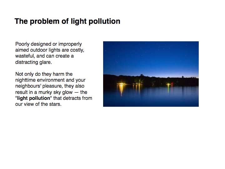
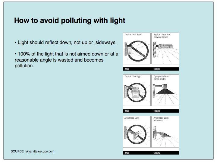
82 80
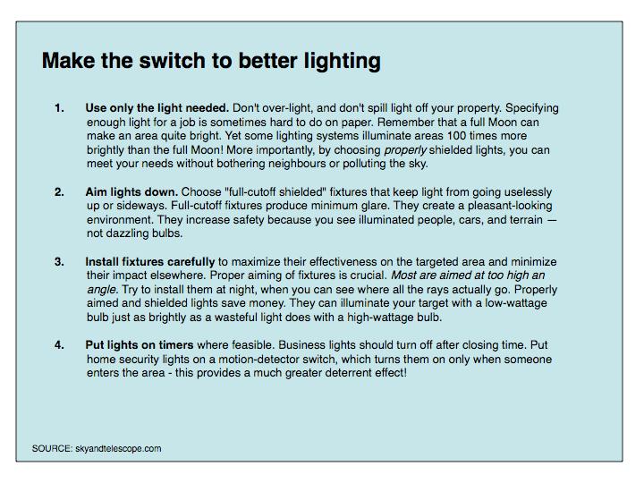
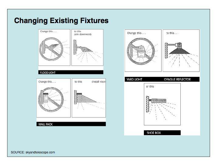
83 81
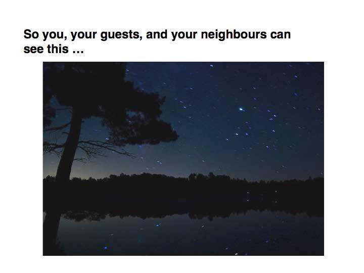
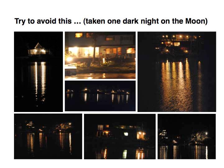
84 82
CHAPTER 4 WATERSHED PLAN GOALS & OBJECTIVES
 4.0 Introduction CHAPTER 4 WATERSHED PLAN GOALS & OBJECTIVES After the watershed analysis had been completed, the next step in the planning process followed by the group was to come up with goals and objectives
Stakeholder Involvement
 Stakeholder Involvement The Portage Lake Watershed Forever Plan began in 2006 as a local initiative by residents, public officials, nonprofit organizations, and business leaders aided by the Manistee County
RIVER ACCESS STRATEGY GUIDING PRINCIPLES & STRATEGIES
 RIVER ACCESS STRATEGY GUIDING PRINCIPLES & STRATEGIES SEPTEMBER 2015 RIVER ACCESS STRATEGY GUILDING PRINCIPLES & STRATEGIES TABLE OF CONTENTS Executive Summary... 3 The Need for a Strategy... 4 What the
H ollow R iver. Stewardship Works! S ubwatershed. Grades. Land Water Wetlands Biodiversity. Not Stressed Not Stressed Not Stressed Vulnerable
 s H ollow R iver Land Water Wetlands Biodiversity S ubwatershed T he Hollow River Subwatershed is 40,863 hectares in size and lies predominantly in the Township of Algonquin Highlands in Haliburton County.
Community Workshops Summary Prepared February 2016
 Community Workshops Summary Prepared February 2016 Introduction Stevens County is preparing an updated Shoreline Master Program (SMP), and the City of Kettle Falls and the towns of Marcus and Northport
B ig E ast R iver. Stewardship Works! S ubwatershed. Grades. Land Water Wetlands Biodiversity. Not Stressed Not Stressed Not Stressed Vulnerable
 s B ig E ast R iver Land Water Wetlands Biodiversity S ubwatershed T he Big East River Subwatershed is 64,699 hectares in area. Major lakes in the subwatershed include Bella Lake (3.45 km2) and Rebecca
REGIONAL GROWTH STRATEGY
 THOMPSON-NICOLA REGIONAL DISTRICT REGIONAL GROWTH STRATEGY Bylaw 2409, 2013 Source: Picture BC Thompson-Nicola Regional District 300-465 Victoria Street Kamloops, BC V2C 2A9 Telephone: 1-250-377-8673 Toll
BACKGROUND. Public Opinion Survey Results: December 2013 Page 2
 THE PROVINCE OF PRINCE EDWARD ISLAND Public Opinion Survey Results: December 2013 Task Force on Land Use Policy Aubin Arsenault Building3 Brighton Road, Charlottetown, PE C1A 7N8Tel: (902) 620 3558Fax:
The Fish River Chain of Lakes Concept Plan
 The Fish River Chain of Lakes Concept Plan Overview and Summary December 2014 THE FISH RIVER CHAIN OF LAKES The Fish River chain of lakes in northern Aroostook County is as special as any place in the
CHAPTER 1 INTRODUCTION
 CHAPTER 1 INTRODUCTION CRYSTAL FALLS TOWNSHIP The image of a cold, snowy climate; a distant, northern, isolated location; and a dwindling economy are part of the folklore for Crystal Falls Township. In
Future Plan Advisory Committee SWOT Analysis Report
 Cultus Lake Official Community & Park Plan Future Plan Advisory Committee SWOT Analysis Report July 16, 2013 1.0 SWOT Analysis On July 2, 2013, the Cultus Lake Park Board Future Plan Advisory Planning
OurFuture. Protecting. March Ontario Provincial Plans and Conservation Authorities
 Protecting OurFuture Ontario Provincial Plans and Conservation Authorities March 2015 Greenbelt Plan I Niagara Escarpment Plan I Growth Plan for the Greater Golden Horseshoe I Oak Ridges Moraine Conservation
The Fish River Chain of Lakes Concept Plan
 The Fish River Chain of Lakes Concept Plan Overview and Summary May 2017 THE FISH RIVER CHAIN OF LAKES THE CONCEPT PLAN The Fish River chain of lakes in northern Aroostook County is as special as any place
Van Buren County Recreation Plan Meeting Page Growing Greener in Southwest Michigan Overview and Significant Findings
 Van Buren County Recreation Plan 02.26 Meeting Page 1 Growing Greener in SW Michigan - OVERVIEW Survey Goals The overall Growing Greener in Southwest Michigan Goal is to develop a regional green infrastructure
1 3 Skills 2 Innovation 5 4
 1 Skills 3 2 Innovation 5 4 C.C. Tatham & Associates Ltd. CCTA is a Canadian, employee-owned engineering consulting firm. Headquartered in Collingwood, with branch offices in Bracebridge, Barrie and Orillia,
Water Level - m Dec 1. Dec/ Jan/ Water Level - m 284.
 Present and Preliminary Preferred Lakes Fairy Lake, Peninsula Lake and Lake Vernon Lower Muskoka High Water Zone Maximum 90 Percentile Mean Median 10 Percentile Minimum Proposed 285.00 284.75 284.50 284.25
Contact us: PO BOX 539, SOUTH RIVER, ON P0A 1X0
 Contact us: PO BOX 539, SOUTH RIVER, ON P0A 1X0 www.eaglelakeconservationassociation.com Charter Mandate: To promote, foster, and improve the quality of the air, water, flora, fauna and the community in
CLAREMONT CONSERVATION COMMISSION CONSERVATION PLAN Adopted 7/21/2016
 CLAREMONT CONSERVATION COMMISSION CONSERVATION PLAN Adopted 7/21/2016 THE CLAREMONT CONSERVATION COMMISSION The Claremont Conservation Commission provides the following services to the City: Advises residents
CLEARWATER TOWNSHIP WATER QUALITY ACTION PLAN
 CLEARWATER TOWNSHIP WATER QUALITY ACTION PLAN Elk-River-Chain-of-Lakes Gaps Analysis Project The Watershed Center Grand Traverse Bay Michigan Department of Environmental Quality July 2011 Purpose The Grand
ARTICLE LAKE ERIE MARINA DISTRICT
 Section 13.01 PURPOSE ARTICLE 13.00 LAKE ERIE MARINA DISTRICT A primary planning goal of Frenchtown Charter Township is to provide a balance and variety of land uses which are compatible to the community
Environment and Natural Resources Trust Fund 2018 Request for Proposals (RFP)
") Environment and Natural Resources Trust Fund 2018 Request for Proposals (RFP) Project Title: Prioritize and Target North-Central Minnesota Lakes for Protection Category: G. Land Acquisition, Habitat and
Environment and Natural Resources Trust Fund 2018 Request for Proposals (RFP) Project Title: Prioritize and Target North-Central Minnesota Lakes for Protection Category: G. Land Acquisition, Habitat and
Burlington s Strategic Plan
 Burlington s Strategic Plan 2015 2018 A Workbook for Planning the Future of Burlington www.burlington.ca/strategicplan The City of Burlington is committed to hearing from you. We can t be everywhere, so
Mayflower Lake Management Planning Committee UWSP Center for Watershed Science and Education Marathon County Wisconsin Department of Natural
 Mayflower Lake Management Planning Committee UWSP Center for Watershed Science and Education Marathon County Wisconsin Department of Natural Resources Reduces conflicts Addresses problems Allows for proactive
General Location and Characteristics 3.1
 Section 3 3.1 General Location and Characteristics Lake Vernon is a mid-sized coldwater lake located within the Town of Huntsville in the District Municipality of Muskoka and is split between the geographic
Through Local Goverment. Through Local Goverment
 Chief of Police The Chief of Police leads the work of police services in a municipality. His or her main responsibilities include making sure that the police service meets the needs of the people and keeps
2006, Queen s Printer for Ontario Printed in Ontario, Canada
 2006, Queen s Printer for Ontario Printed in Ontario, Canada Single copies of this publication are available at no charge from the address noted below. Bulk orders may involve charges. Natural Resources
Lakeshore Capacity July, 2018
 WLPP INFORMATION BULLETIN Lakeshore Capacity July, 2018 This WLPP Bulletin provides information on the concept and approach used to define, calculate and assess lakeshore capacity. In addition, the Bulletin
SAUGEEN CONSERVATION Year in Review
 2007 Year in Review 111 Our Lands Our Treasures Our Future! Over 21,000 Acres of Natural Treasures Something to be proud of! 112 WHAT DO OUR LANDS DO FOR US? A) Recreational Opportunities/ & Impact to
NATURAL RESOURCES Vision Statement
 NATURAL RESOURCES Vision Statement Citizen and local government practices reflect good stewardship of the water, air and earth. Air and water quality are preserved and cold water springs protected. Light
Update for Meaford Council on Grey Sauble Conservation Authority and its Programs. March 20, 2017
 Update for Meaford Council on Grey Sauble Conservation Authority and its Programs March 20, 2017 1 Purpose To update Meaford Council on the work of the Grey Sauble Conservation Authority (GSCA) This update
What is a Wetland Worth?
 What is a Wetland Worth? March 2007 Developed By: Kate Bullard Adapted From: Council for Environmental Education. Oregon Project WILD Aquatic. K-12 Curriculum and Activity Guide. 2004. Mitsch, William
6 January 12, 2011 Public Hearing APPLICANT & PROPERTY OWNER: ROBERT L. NELSON & BRENDA N. GRAY T/A WEST LANDING MARINA
 6 January 12, 2011 Public Hearing APPLICANT & PROPERTY OWNER: ROBERT L. NELSON & BRENDA N. GRAY T/A WEST LANDING MARINA STAFF PLANNER: Carolyn A.K. Smith REQUEST: Modification of Conditions of a Conditional
Adapting to Climate Change in Kimberley, BC. Executive Summary June Prepared by Ingrid Liepa
 Adapting to Climate Change in Kimberley, BC Executive Summary June 2009 Prepared by Ingrid Liepa Executive Summary The City of Kimberley was selected by the Columbia Basin Trust (CBT) in April 2008 as
GUIDE FOR APPLYING FOR A BUILDING PERMIT
 Township Of Perry/Township Of Armour Township of McMurrich/Monteith GUIDE FOR APPLYING FOR A BUILDING PERMIT These next few pages are designed to assist you in applying for a building permit. This guide
AVALONIA LAND CONSERVANCY FEE LAND STEWARDSHIP PRINCIPLES
 AVALONIA LAND CONSERVANCY FEE LAND STEWARDSHIP PRINCIPLES This document has been prepared for guidance in developing Property Management Plans for individual properties Avalonia owns in fee. It sets forth
District of Muskoka Planning and Economic Development Department. Lake of Bays Association Executive Committee
 Date: November 10, 2017 To: From: C.C. District of Muskoka Planning and Economic Development Department Lake of Bays Association Executive Committee Lake of Bays Association Board of Directors Township
ANGLESEA FUTURES Land Use Scenarios Summary of Feedback - December 2017
 ANGLESEA FUTURES Land Use Scenarios - Summary of Feedback December 2017 ANGLESEA FUTURES Land Use Scenarios Summary of Feedback - December 2017 i Acknowledgements The Victorian Government s Department
District of Muskoka Official Plan Draft October 5, 2017
 Made in Muskoka District of Muskoka Official Plan Draft October 5, 2017 A land use and community development plan based on the principles of sustainability and recognizing the unique context of the District
BIG ROCHE A CRI LAKE CHARACTERISTICS
 BIG ROCHE A CRI LAKE CHARACTERISTICS Lake Description Big Roche Cri Lake is located in north central Adams County and has a surface area of 205 acres, a shoreline length of 6.1 mile, a volume of 6,993
A Letter from the CLA President
 Circle Lake Association Annual Report 2017 Contents A Letter from the CLA President... 3 Native Planting 2017... 4 2017 Circle the Lake Half Marathon, 10K, and 5K... 5 Watershed... 6 Lake Improvement District...
Parks and Forest Accomplishments
 Parks and Forest The Parks & Forest Department manages the timber sales, county forest roads, wildlife habitat improvement projects, and other operations on the county forest (52,670 acres), three county
Lakeshore Capacity July, 2018
 WLPP INFORMATION BULLETIN Lakeshore Capacity July, 2018 This WLPP Bulletin provides information on the concept and approach used to define, calculate and assess lakeshore capacity. In addition, the Bulletin
This page left intentionally blank
 Township of Wilmot Strategic Plan Council Approved June 3, 2013 This page left intentionally blank Contents Contents... i 1. What s YOUR Wilmot A Roadmap for the Future... 1 2. Introduction to Wilmot s
Community Meeting Barnardsville Resource Center - January 17, 2006 Needs/Issues. Group 1
 Community Meeting Barnardsville Resource Center - January 17, 2006 Needs/Issues Group 1 Encouraging Local Economy Community Development Air & Water Quality Cultural Preservation Roads/Safety Natural Preservation
Executive Director s Message
 Annual Report 2013/2014 Executive Director s Message This has been a year of change for us at Watersheds Canada, starting with a new office in Perth, Ontario, and rebranding of our organization including
Issues, Concerns & Constraints
 Identifying Issues, Concerns & Constraints In order to identify the issues and concerns of watershed residents, several methods of gathering public input were employed. The Brodhead Watershed Association
ELK RAPIDS TOWNSHIP WATER QUALITY ACTION PLAN
 ELK RAPIDS TOWNSHIP WATER QUALITY ACTION PLAN Elk-River-Chain-of-Lakes Gaps Analysis Project The Watershed Center Grand Traverse Bay Tip of the Mitt Watershed Council Michigan Department of Natural Resources
Where Funds are Spent
 Page 1 of 10 DNR FY 2014-15 Budget 2013 Legislative Session Where Funds are Spent The DNR is organized into seven operating divisions, or programs, for managing where funds are spent. The Divisions are
Clam Lakes (Lower & Upper), Burnett County Four-Phased Lake Management Planning Project Description
, Burnett County Four-Phased Lake Management Planning Project Description") 1 Clam Lakes (Lower & Upper), Burnett County Four-Phased Lake Management Planning Project Description Lake and Watershed Characteristics The Clam Lakes are a combined 1544 acres with Upper Clam Lake essentially
1 Clam Lakes (Lower & Upper), Burnett County Four-Phased Lake Management Planning Project Description Lake and Watershed Characteristics The Clam Lakes are a combined 1544 acres with Upper Clam Lake essentially
WATERSHED. Maitland Valley. Report Card 201
 Maitland Valley WATERSHED Report Card 201 The Maitland Valley Conservation Authority has prepared this report card as a summary on the state of our forests, wetlands, surface water, and ground water resources.
Toronto and Region Conservation 2017 Progress & 2018 Budget Peel Council
 Toronto and Region Conservation 2017 Progress & 2018 Budget Peel Council November 16, 2017 1 2 Input $4,248,000 44 Projects Activities Watershed 2017 Output Increased coverage of Flood Monitoring and Real
Pike County: Where People, Land and Water Meet. Will your actions today protect the natural resources for the next generation?
 Pike County: Where People, Land and Water Meet Will your actions today protect the natural resources for the next generation? Residents & visitors of Pike County share fond memories of swimming and fishing
Official Plans. Zoning By-laws. Site Plan Control Development Approvals and Agreements. Figure 28 Municipal Planning Tools
 Section 7 The purpose of this section is to identify known future growth areas in the Town of Huntsville and describe the municipal planning documents and regulations that apply to Lake Vernon in order
Business Plan: Kettle Creek Conservation Authority
 Business Plan: Kettle Creek Conservation Authority How does this service contribute to the results identified in the City of London Strategic Plan? A Green and Growing City A Sustainable Infrastructure
WELCOME. RM of Big River Official Community Plan & Zoning Bylaw. The purpose of this Open House is: What is a Zoning Bylaw? Background information:
 WELCOME The purpose of this Open House is: To present highlights of the draft versions of proposed new planning bylaws (Official Community Plan and Zoning Bylaw) for the Rural Municipality of Big River
Too much we don t know Too many mis-statements
 SaveTheBalaFalls.com Too much we don t know Too many mis-statements Presentation to Township of Muskoka Lakes Council (Presentation was scheduled, but Township had to cancel it) December 14, 2010 Good
Strategic Plan. Grand River Conservation Authority
 Grand River Conservation Authority Strategic Plan The Grand River Conservation Authority is a partnership of 39 municipalities created to manage water and natural resources for the benefit of the 960,000
BLUE HILL BAY WATERSHED NEEDS ASSESSMENT
 BLUE HILL BAY WATERSHED NEEDS ASSESSMENT This report was prepared by the Hancock County Planning Commission under award NOAA CZM NA11NOS4190077 and NA11NOS4190188 from the National Oceanic and Atmospheric
Request for Decision STAFF REPORT. Recommendation. Presented To: Planning Committee. Presented: Tuesday, Jan 11, 2011
 Request for Decision Application for Rezoning in order to permit a permanent waterfront residential use in a seasonal zone on Makada Lake, 110 Clark Road, Lively - Margaret & James Johnson Presented To:
A group of Edmontonians regularly get together to pull weeds other invasive plants from natural areas in Edmonton s Mill Creek and Fulton Ravine.
 ENGAGEMENT EXAMPLES This section provides a sample of public engagement initiatives and projects. Additional information can be found in the Appendices and online at www.edmonton.ca/openengagement Public
2013 RBC Canadian Water Attitudes Study
 2013 RBC Canadian Water Attitudes Study 11 Table of Contents A note from RBC Methodology Detailed Results General Context Extreme Weather House & Home: Outdoor Water Behaviour Efficiency & Conservation
RP Municipal Reserves, Parks and Campgrounds
 -01 Introduction For the purposes of this policy, lakeshore municipal reserve lands include municipal reserves, environmental reserves and public roadway rights-of-ways as defined in the Municipal Government
INFRASTRUCTURE SPOTLIGHT: CANADA S SMALL AND RURAL COMMUNITIES
 July 2012 INFRASTRUCTURE SPOTLIGHT: CANADA S SMALL AND RURAL COMMUNITIES Millions of Canadians live and work in small and rural communities. With economies often driven by natural resources and local industries,
Credit Valley Conservation (CVC) Board of Directors. Chief Administrative Officer (CAO) Watershed Knowledge. Watershed Management
 Board of Directors. Chief Administrative Officer (CAO) Watershed Knowledge. Watershed Management") Credit Valley Conservation (CVC) Board of Directors Chief Administrative Officer (CAO) CVC Foundation Human Resources Corporate Watershed Knowledge Watershed Watershed Transformation Planning and Development
Credit Valley Conservation (CVC) Board of Directors Chief Administrative Officer (CAO) CVC Foundation Human Resources Corporate Watershed Knowledge Watershed Watershed Transformation Planning and Development
Hiawatha: Your Great Lakes National Forest
 Outreach Lead Forestry Technician (Timber Sale Prep) Raco, Michigan HIAWATHA NATIONAL FOREST MARCH 29, 2013 Outreach Hiawatha National Forest will be filling a Lead Forestry Technician (Timber Sale Preparation)
Hiawatha: Your Great Lakes National Forest
 Outreach Lead Forestry Technician (Timber Sale Prep) Raco, Michigan HIAWATHA NATIONAL FOREST MARCH 29, 2013 Outreach Hiawatha National Forest will be filling a Lead Forestry Technician (Timber Sale Preparation)
References: A. MLA Survey (12 questions) promulgated in 2012 B. Survey data report (17 pages, in pie chart format), completed Dec 2013
 promulgated in 2012 B. Survey data report (17 pages, in pie chart format), completed Dec 2013") ANALYSIS REPORT MISSISSIPPI LAKE PLAN SURVEY References: A. MLA Survey (12 questions) promulgated in 2012 B. Survey data report (17 pages, in pie chart format), completed Dec 2013 INTRODUCTION This is
ANALYSIS REPORT MISSISSIPPI LAKE PLAN SURVEY References: A. MLA Survey (12 questions) promulgated in 2012 B. Survey data report (17 pages, in pie chart format), completed Dec 2013 INTRODUCTION This is
Three Rivers Region Public Consultation Process. Summary Report
 Three Rivers Region Public Consultation Process Summary Report October 2016 Message from the Chair Three Rivers Region Steering Committee Dear Residents of the Three Rivers region, On behalf of the Three
S E C T I O N. six. Environment
 S E C T I O N six Environment 202 VOLUME 15: EXAMPLES OF SUCCESSFUL PUBLIC-PRIVATE PARTNERSHIPS 23 Chesapeake Forest, Maryland, United States P R O J E C T S U M M A R Y The Chesapeake Bay is the largest
Frequently Asked Questions
 Frequently Asked Questions Chelan County Shoreline Master Program Update July 2009 What is an SMP? Shoreline Master Programs (SMP) are a combination of rules and comprehensive planning that are prepared
Options for Preventing the Spread of Aquatic Invasive Species with the aid of Boat Cleaning and Wash Stations in New Hampshire
 Options for Preventing the Spread of Aquatic Invasive Species with the aid of Boat Cleaning and Wash Stations in New Hampshire New Hampshire Lakes Association 14 Horseshoe Pond Lane Concord, NH 03301 603.226.0299
[] The Red Cedar River and its Streams (Fall 2001)
![[] The Red Cedar River and its Streams (Fall 2001)](/thumbs/81/84582489.jpg "[] The Red Cedar River and its Streams (Fall 2001)") [] The Red Cedar River and its Streams (Fall 2001) This is an opportunity for you to provide information for local water resource planning. Your input will help planners make informed water quality decisions.
[] The Red Cedar River and its Streams (Fall 2001) This is an opportunity for you to provide information for local water resource planning. Your input will help planners make informed water quality decisions.
HOW TO OBTAIN A BUILDING PERMIT
 HOW TO OBTAIN A BUILDING PERMIT A GUIDE TO THE HOMEOWNER Copies of this Guide can be obtained from the Building Department upon request THE CORPORATION OF THE TOWNSHIP OF GEORGIAN BAY BUILDING DEPARTMENT
COUNTY COMPREHENSIVE PLAN
 86 : Policy Statement Lewis County has an abundance of natural resources, including water, wind, soils, and wildlife. Together with our citizens, they form a unique ecosystem that must be preserved and
British Columbia s. VVater Act. Modernization. Policy Proposal on British Columbia s new Water Sustainability Act. December 2010
 British Columbia s VVater Act Modernization Policy Proposal on British Columbia s new Water Sustainability Act December 2010 British Columbia has a rich heritage in our lakes, rivers and streams. Linked
OFFICIAL PLAN. Office Consolidation
 OFFICIAL PLAN Office Consolidation As approved by the Ministry of Municipal Affairs and Housing (December 17, 2012) and Ontario Municipal Board (August 4, 2016) and As amended by Official Plan Amendments
Public Lands In-Depth Version 1.1, 3/29/2018
 Public Lands In-Depth Version 1.1, 3/29/2018 This document is a comprehensive collection of data and information about Minnesota s public lands, focusing on the state lands managed by the DNR. It details
Compass Lake in the Hills
 Compass Lake in the Hills Property Owners Association Volume 1, Issue 1 June 2018 Cancellation of the MSTU contract with Jackson County How it affects our community President, POA Board of Directors In
Lines of Communication. Our New Approach to Consultation - Have Your Say
 Lines of Communication Our New Approach to Consultation - Have Your Say Who are EirGrid - and what do we do? What is this guide for? EirGrid is responsible for a safe, secure and reliable supply of electricity:
Almeley Neighbourhood Development Plan (2011 to 2031)
") Almeley Neighbourhood Development Plan (2011 to 2031) CONSULTATION: DRAFT VISION & OBJECTIVES WHAT IS THE ALMELEY NEIGHBOURHOOD DEVELOPMENT PLAN? Neighbourhood Development Plans (NDPs) contain planning
Almeley Neighbourhood Development Plan (2011 to 2031) CONSULTATION: DRAFT VISION & OBJECTIVES WHAT IS THE ALMELEY NEIGHBOURHOOD DEVELOPMENT PLAN? Neighbourhood Development Plans (NDPs) contain planning
Mediation Telfs, Austria December 2005
 Fact Sheet Future use and development of the green area in the west of Telfs, Austria Type of procedure Mediation procedure Other: Procedure including mediation elements Topic area Urban and land use planning
Village of Chipman. Strategic Plan
 2017-2020 Chipman is a diverse, vibrant community, committed to growth and development where all ages may learn, work, play and live in an engaging environment. Introduction The, established in 1966, is
Why The Oak Tree on Allman Avenue is Special
 Why The Oak Tree on Allman Avenue is Special Some trees are kept as markers or monuments so that visitors can remember certain events or people. The Red Oak tree on the Kuse farm on Allman Avenue is that
MEDIA RELEASE FOR IMMEDIATE RELEASE January 17, 2018
 BRACEBRIDGE, ON On January 16, 2017, Mayor Graydon Smith, on behalf of Bracebridge Town Council, travelled to Sudbury to make a presentation to the Provincial Standing Committee on Finance and Economic
Board of Supervisors Working Session October 4, 2010
 Board of Supervisors Working Session October 4, 2010 Multiple Zoning Classifications: Conservation (C-1) Agricultural (A-1) Residential Waterfront (R-2) Multiple Zoning Classifications: Conservation (C-1)
Interim Management Plan for the Maple Shade Town Forest Westford, Vermont
 Interim Management Plan for the Maple Shade Town Forest Westford, Vermont Prepared by: Westford Conservation Commission; Sarah Pinto, Chair Ethan Tapper, Chittenden County Forester With information from
James Bay Cree Governance Project
 James Bay Cree Governance Project The James Bay Cree needed broad community input on governance, in order to negotiate with provincial and federal authorities, and look at their internal governance processes.
Home Sharing: The Positive Impacts on Dublin
 Home Sharing: The Positive Impacts on Dublin Welcome from Airbnb / 2 Executive Summary / 3 Airbnb Community Overview / 4 Increasing Tourism to all of County Dublin: Guest Overview / 9 Helping Dubliners
Community Action Programs for the Environment
 Community Action Programs for the Environment We want to help protect endangered fish on our reserve from the effects of water pollution. Our school wants to share our cool ideas about sustainability with
Good Afternoon. I'm State Representative Sarah Roberts serving in the Michigan House of
 Good Afternoon. I'm State Representative Sarah Roberts serving in the Michigan House of Representatives. I am not a geologist, a scientist nor an expert on nuclear waste. But I am elected to be the voice
PE PLE WHO POLLUTED THE RIVER?
 UNIT 7 PEOPLE AND WASTE WHO POLLUTED THE RIVER? COUNTING ON PE PLE K-5 Activities for Global Citizenship METHOD Through an interactive story, K-2 students experience the pollution of a local river over
STAFF REPORT. Permit Number: Tallman. Kitsap County Board of Commissioners; Kitsap County Planning Commission
 STAFF REPORT Permit Number: 15 00742 Tallman DATE: November 9, 2015 TO: FROM: RE: Kitsap County Board of Commissioners; Kitsap County Planning Commission Katrina Knutson, AICP, Senior Planner, DCD and
3. Key Stakeholders & Public Participation in Plan Development
 3. Key Stakeholders & Public Participation in Plan Development 3.1. Initiation of the Watershed Management Plan In the 20 th century, Huron Creek and the surrounding watershed were recreational resources
Discussion Paper Conservation Authorities Act
 Discussion Paper Conservation Authorities Act A review of the roles, responsibilities, funding and governance of conservation authorities under the Conservation Authorities Act. Photo credits: Cover photos
2016 Annual Volunteer Report
 2016 Annual Volunteer Report Volunteer Statistics Summary 21,954 DNR 268,817 Hours Donated 129 FTE s (Full Time Equivalents based on a 40-hour work week or 2,080 hours/year.) Volunteer hours are equivalent
Lincoln - OFFICIAL PLAN PART 1 INTRODUCTION 1.1. THE COMMUNITY VISION
 Lincoln - OFFICIAL PLAN PART 1 INTRODUCTION 1.1. THE COMMUNITY VISION The vision for Lincoln is to be a Centre of Excellence for Agriculture; an inclusive community that values diversity, partnerships,
A New Jersey forester visits Montana and is. reminded that public forest management, land use. planning, and fire policy are national concerns.
 A New Jersey forester visits Montana and is reminded that public forest management, land use planning, and fire policy are national concerns. By Bob Williams That experience only further convinced me that
A VISION FOR THE UPPER ILLINOIS RIVER WATERSHED
 June 2010 A VISION FOR THE UPPER ILLINOIS RIVER WATERSHED Funded by Arkansas Natural Resources Commission and the Walton Family Foundation through the Illinois River Watershed Partnership MSC Publication
Green - Green Space & Habitat
 Green - Green Space & Habitat Healthy and resilient ecosystems. Why green space and habitat matter: People, plants and wildlife all depend on healthy habitat. Green space makes our city more livable. It
Homeowner Services Life is better At The Lake! Lakes Region, NH. LakesRegionRentals.com.
 Let us put your home to work for you! Life is better At The Lake! Lakes Region, NH Homeowner Services LakesRegionRentals.com 603-253-9871 If your home is listed with a broker, this is not meant as a solicitation