TOWN OF SOUTH PALM BEACH, FLORIDA COMPREHENSIVE PLAN
|
|
|
- Ezra Bradford
- 6 years ago
- Views:
Transcription
1 TOWN OF SOUTH PALM BEACH, FLORIDA COMPREHENSIVE PLAN 1989 REVISED 2008
2 TOWN OF SOUTH PALM BEACH COMPREHENSIVE PLAN March 1, 1989 Revised July 21, 1989; October, 2008 Prepared by: TOWN OF SOUTH PALM BEACH And DESIGN PLAN/RESEARCH Jupiter, Florida With COASTAL PLANNING & ENGINEERING, INC. Boca Raton, Florida 2008 Revisions Ragsdale Planning Group, Inc. 2
3 Comprehensive Plan March 1, 1989 Revised July 21, 1989 October, 2008 Prepared by: Town of South Palm Beach And Design Plan/Research Jupiter, Florida Revision by: Coastal Planning & Engineering, Inc Revision by: Ragsdale Planning Group, Inc. 3
4 TOWN COUNCIL Maurice J. Jacobson, Mayor Charles J. McCrosson, Vice-Mayor Martin Millar, Councilor Dr. Joseph Flagello, Councilor Donald Clayman - Councilor Rex Taylor, Town Manager PLANNING BOARD Michael Nevard - Chairman Michael Mead Vice Chair Deborah (Dee) Robinson Patricia H. Festino Patricia Schulmayr COMPREHENSIVE PLANNING CONSULTANTS Ragsdale Planning Group, Inc. 4
5 TABLE OF CONTENTS PAGE INTRODUCTION 8 CHAPTER 1 POPULATION 9 I. Resident Population Growth 10 II. Population Characteristics 11 III. Household Characteristics 11 IV. Population Projections 12 CHAPTER 2 PUBLIC PARTICIPATION & PLAN EVALUATION 13 I. Public Participation 14 II. Monitoring & Evaluation 15 CHAPTER 3 FUTURE LAND USE ELEMENT 16 I. Existing Land Use Data 17 II. Land Use Analysis 19 III. Future Land Use Map 21 IV. Goals, Objectives, and Policies 24 CHAPTER 4 TRANSPORTATION ELEMENT 26 I. Transportation Data 27 A. Existing Traffic Circulation 27 B. Functional Classification 27 II. Traffic Circulation Analysis 29 A. Existing Traffic Circulation 29 B. Analysis of Projected Needs 29 III. Goals, Objectives, and Policies 31 CHAPTER 5 HOUSING ELEMENT 33 I. Residential Growth 34 II. Inventory 34 III. Housing Analysis 36 IV. Goals, Objectives, and Policies 37 CHAPTER 6 INFRASTRUCTURE ELEMENT 38 I. Data and Analysis 39 A. Sanitary Sewer 39 B. Solid Waste 40 C. Drainage 41 D. Portable Water 41 II. Goals, Objectives, and Policies 43 CHAPTER 7 COASTAL MANAGEMENT ELEMENT 46 I. Data and Analysis 47 A. Existing Land Uses 47 B. Water Dependant & Water Related Uses 48 C. Effect of Future Land Use 48 D. Impact on Historical Resources 48 E. Estuarine Pollution 48 F. Hurricane Evacuation/Disaster 51 G. Coastal High-Hazard Areas 53 H. Post-Disaster Redevelopment 53 II. Goals, Objectives, and Policies 56 5
6 CHAPTER 8 CONSERVATION ELEMENT 61 I. Environmental Settings 62 II. Inventory and Analysis 62 A. Water Resources 62 B. Air Quality 62 C. Floodplains 62 D. Commercially Valuable Minerals 63 E. Soil Erosion 63 F. Flora and Fauna 63 G. Commercial, Recreational, and Conservation Uses 64 H. Pollution Problems 64 I. Water Use 66 III. Goals, Objectives, and Policies 66 CHAPTER 9 RECREATION & OPEN SPACE ELEMENT 69 I. Existing Facility Inventory 70 II. Facility Needs Analysis 70 III. Goals, Objectives, and Policies 71 CHAPTER 10 INTERGOVERNMENTAL COORDINATION ELEMENT 73 I. Inventory of Entities 74 A. Adjacent Municipalities 74 B. Other Local Governments 74 C. Special Function Local Agencies 74 D. Utilities 75 E. Regional Agencies 75 F. State Agencies 75 II. Analysis 75 A. Existing Coordination Mechanism 76 B. Comprehensive Plan Elements 76 C. Comprehensive Regional Policy Plan 77 III. Goals, Objectives, and Policies 77 CHAPTER 11 CAPITAL IMPROVEMENTS ELEMENT 79 I. Inventory 80 A. Needs Derived From Other Elements 80 B. Public Educational & Healthcare Facilities 80 C. Existing Revenue Sources & Funding Mechanisms 80 II. Analysis 81 A. Local Conditions and Practices 81 III. Goals, Objectives, and Policies 81 IV. Implementation 83 Monitoring & Evaluation 83 ATTACHMENT A 10 YEAR WATER SUPPLY FACILITY WORK PLAN SUBEMEMENT 84 6
7 LIST OF MAPS Map Title Page 1 Existing Land Use Generalized Soils Map 20 2 Future Land Use Map Year Flood Prone Areas 23 4 Existing Traffic Circulation 28 5 Future Traffic Circulation 30 6 Hurricane Evacuation Route 52 7 Coastal High Hazard Area 55 LIST OF TABLES 1 Population Growth 10 2 Age of Residents Comparison 1989 to Gender Comparison to Existing Land Use 17 5 Future Land Use 21 6 Average Daily Traffic 29 7 Number of Dwelling Units by Age 35 8 Tenure Characteristics of Housing Stock 35 9 Summary of Sewage Treatment Capacity Allocation, City of Lake Worth Utilities Existing Land Uses State, Regional and Local Regulatory Agencies and Programs which Maintain or Improve Estuarine Environmental Quality Special Protection Status of Wildlife Recreational Facility Inventory 70 7
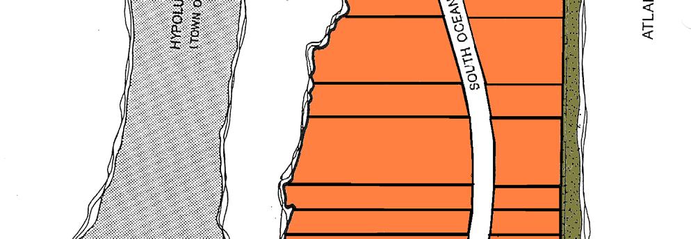
8 INTRODUCTION The Town The Town of South Palm Beach occupies a strip of oceanfront property five-eights of a mile in length on the barrier island between the Town of Palm Beach to the north, and the Town of Lantana to the south. The easternmost boundary of the Town is the Atlantic Ocean and the western boundary is defined by the shoreline of the lagoon created by the northern end of Hypoluxo Island in Lantana. The Town is situated approximately one mile east of U.S. Highway 1 and about two miles south of Lake Worth Road. The only public road in the Town is State Road A1A which is locally known as South Ocean Boulevard. The development of the present Town of South Palm Beach began in July 1955 when the Town was incorporated. The Town grew at a slow and steady pace until the boom of the early seventies, which produced over a thousand units within a little over a year. Since then, the Town continued growing, but at a much slower pace. Presently, the Town is completely built out. The Plan The Comprehensive Plan of the Town of South Palm Beach as presented here was prepared to meet the requirements of the Florida Local Government Comprehensive Planning and Land Development Regulation Act of 1985, Chapter 163, Florida Statutes. The Plan was prepared in accordance with the guidelines established in Chapter 9J-5, Florida Administrative Code. The Plan contains nine required elements in addition to sections on population and public participation. The nine elements of the Plan are: Future Land Use, Transportation, Housing, Infrastructure, Coastal Management, Conservation, Recreation and Open Space, Intergovernmental Coordination, and Capital Improvements. Each element contains data and analysis sections which form the basis for the goals, objectives and policies which follow. Unlike most local governments in Florida, growth management is hardly an issue in the Town of South Palm Beach, since the Town is built out. The primary concerns of the Town are protection of the existing quality of life and preservation of natural resources. These are the issues that the Plan focuses on. Since the entire Town is a coastal area, coastal management is the element where these issues are primarily addressed. 8
9 POPULATION 9
10 CHAPTER 1 POPULATION I. RESIDENT POPULATION GROWTH Historically, the growth of the Town of South Palm Beach has been somewhat sporadic compared to the growth pattern of Palm Beach County or the State of Florida as can be seen in Table 1. From its incorporation in 1955 until the early seventies, the Town grew at an extremely sluggish pace and reached a population of 188 in Then came the building boom of the early seventies, in which over one thousand units were built within a little over a year. After a short lull following the boom, the Town managed to grow at a steady pace to The Town has been considered built out since that time. In terms of population, the Town grew from a population of 113 in 1960 to 188 in 1970, a growth rate of over sixty-six percent (66%) for the decade. The Town reached a population of 1304 in 1980 largely due to the building boom of the early seventies resulting in an increase of nearly six-hundred percent (600%) over a period of ten (10) years. Since its incorporation, the Town has grown at a much faster rate than either Palm Beach County or the State of Florida until its growth started slowing down following the boom of the early seventies. From 1980 through 1986, the Town s population grew by only 8.1 percent (8.1%) (an annual growth rate of one point three five percent (1.35%) compared with thirty point three percent (30.3%) growth of Palm Beach County and nineteen point six percent (19.6%) for the State of Florida. Between 1986 and 2006 the Town grew by a total of 116 permanent residents. Future population growth will be limited to approximately 316 persons occupying the 180 additional units that could be constructed on some properties if redevelopment occurs. TABLE 1 POPULATION PROJECTIONS, TOWN OF SOUTH PALM BEACH Year Resident Seasonal Total * * ** ** *** * Projection ** April 1, 2000 Census estimates of population indicated a permanent population of 1,708. April 1, 2004 population estimates from the Bureau of Economic and Business Research, University of Florida also indicate a permanent population of 1,531. *** April 1, 2006 population estimates from the Bureau of Economic and Business Research, University of Florida indicate a permanent population of NOTE: Population projections for the years 2011 and 2016 are based on the potential for redevelopment of certain properties that are presently developed at less than the allowed density. Redevelopment of these properties at the allowed density would allow a maximum of 180 additional residential units. The projections reflect 30 units being constructed in the five year projection period an additional 30 units being constructed in the ten year projection period. Current person per unit numbers were used to determine the resident, seasonal and total population projections. The Town of South Palm Beach is bounded on the north and south by municipalities and on the east and west by water bodies. Annexation is not an option to accommodate additional residents. Increasing density within the Coastal High Hazard Area that comprises the entire town is also not an acceptable alternative to accommodate population growth. Demographic profiles resulting in additional persons per unit are unlikely to change significantly in the foreseeable future.
11 II. POPULATION CHARACTERISTICS A. Age and Sex The population of South Palm Beach continues to have a much different age composition than either Palm Beach County or the State of Florida as a larger portion of the Town s population compromises retired people. Tables 2 and 3 indicate the age and sex composition of the Town s population. TABLE 2 AGE OF RESIDENTS COMPARISON 1989 TO 2004 AGE CATEGORY* 1989 COMPREHENSIVE PLAN 2004 ESTIMATES % 2.1 % % 1.9 % % 11.3 % % 30.5 % OVER % 54.2% *Age categories were revised from 1989 Comprehensive Plan based on available 2004 data. Source: 1989 South Palm Beach Comprehensive Plan; US Census Bureau By comparison, based on the 2000 census, in Palm Beach County 26.2 percent of residents are over 65 years of age and 21.3 percent are under 18. Statewide 17.6 percent are over 65 and 22.8 percent are under 18. TABLE 3 GENDER COMPARISON 1989 TO 2004 GENDER 1989 COMPREHENSIVE PLAN 2004 MALE 44.4 % 42.9 % FEMALE 55.7 % 57.1 % Source: 1989 Comprehensive Plan; US Census Bureau III. HOUSEHOLD CHARACTERISTICS Household characteristics of South Palm Beach continue to be substantially different from those of Palm Beach County and the State of Florida due to the greater percentage of retiree population which falls in the post child-raising age groups. The most striking difference is in the household size which was far smaller in the Town of South Palm Beach (1.76) in 1980 as compared to the size of Palm Beach County (2.42) or the State of Florida (2.55). The average household size continues to fall well below the Palm Beach County and State of Florida numbers. The 2000 Census indicates an average household size of 1.54 in South Palm Beach compared to 2.34 in Palm Beach County and 2.46 statewide. 11
12 IV. POPULATION PROJECTIONS The Town of South Palm Beach is completely built out. This is the single most important factor to be taken into consideration in projecting the Town s population through the year 2016 as shown in Table 1 in keeping with the following assumptions: 1. The population of the Town of South Palm Beach is very close to a saturation point. It is assumed that the Town s population will reach that point over the next 25 to 30 years as redevelopment of the existing condominium buildings occurs. 2. There are no remaining vacant properties within the Town limits. 3. A major shift in the age or sex composition of the Town s population is not anticipated in the foreseeable future. The median age of the Town s population will increase slightly over the years. 4. The resident component of the Town s population will increase gradually with the corresponding decrease in the seasonal component. This is based on the current trend caused by less movement between northern and southern residences as the population ages. 5. The average household size in South Palm Beach will decline only marginally over the years. 6. The existing motel (Palm Beach Oceanfront Inn) will continue to exist as a motel with fifty-eight (58) units through the year
13 PUBLIC PARTICIPATION 13
14 CHAPTER 2 PUBLIC PARTICIPATION AND PLAN EVALUATION I. PUBLIC PARTICIPATION It is the policy of the Town of South Palm Beach to seek public input throughout the entire comprehensive planning process including consideration of amendments to the Comprehensive Plan and preparation of Evaluation and Appraisal Reports (EAR). The Town recognizes that public input must be sought through a variety of channels, both formal and informal, in order to ensure that the residents of the Town will have ample opportunity to express their concerns and opinions as they may relate to comprehensive planning. In order to implement this policy of the Town encouraging public participation in the planning process, the following procedures are established: A. The Town shall advertise in a newspaper of general circulation in the Town, any official action that will affect the use of real property in South Palm Beach. Such action shall generally include adoption of a Comprehensive Plan or a Land Development Regulation Ordinance, or any revision or modification to such a plan or ordinance including any change in Zoning Regulations. B. During the comprehensive planning process, timely written notices shall be sent to all condominium homeowners associations and owners of single family residences in the Town in order to keep the Town s residents informed of the status of the plan and to seek their written comments as they may relate to comprehensive planning. Such notices shall indicate the information available for review at the Town Hall. C. Public Hearings shall be held in conformance with Chapter 163, F. S. by the Local Planning Agency and the Town Council prior to adoption of a Comprehensive Plan or any element of the Plan or any revision to such a Plan or any element of the Plan. D. The Local Planning Agency shall take into consideration all written and verbal comments received from the Town s residents in connection with the Comprehensive Plan during the planning process, and shall prepare a response statement to such comments prior to adoption of the Plan by the Town Council. Copies of the response statement shall be sent to the members of the Town Council and the individuals, organizations and agencies who had made comments during the planning process, at least two weeks prior to the final Public Hearing to be conducted by the Town Council in the Plan adoption process. E. The Local Planning Agency shall release information at regular intervals during the planning process. Copies of the information to be released shall be made available for review at Town Hall. 14
15 II. MONITORING AND EVALUATION In the preparation of the required seven-year Evaluation and Appraisal Reports (EAR), the following procedures shall be followed: A. The Town shall follow adoption procedures outlined in Florida Statutes and the Florida Administrative Code. Additional public input may be solicited by the Town Council at their discretion. B. The Evaluation and Appraisal Report shall include updating of the baseline data pertaining to population, housing and traffic, and measurable objectives to be accomplished in the seven-year intervals of the Plan adoption and for the long-term period. C. The Evaluation and Appraisal Report shall describe accomplishments in the first seven-year period and the degree to which the goals, objectives and policies have been successfully reached. The report shall also identify obstacles or problems which resulted in under achievement of goals, objectives or policies. D. In order to correct the problems identified, the Evaluation and Appraisal Report shall modify the existing goals, objectives or policies, or establish new ones. E. In order to ensure continuous monitoring and evaluation of the Plan during the seven-year period, the Town Manager s office shall prepare an ANNUAL STATUS REPORT outlining any major change in the baseline data, plan amendments, specific problems encountered in the accomplishments of goals, objectives or policies, and comments received from the concerned citizens. 15
16 FUTURE LAND USE 16
17 CHAPTER 3 FUTURE LAND USE ELEMENT I. EXISTING LAND USE DATA The Town of South Palm Beach is an ocean-front community predominately residential in character. As of March 2006, the residential land use accounted for eighty-four point five percent (84.5 %) of the total land area within the Town s jurisdiction. There are only two types of residential land uses existing in the Town: single-family and multi-family of which the latter accounts for eighty-two point five percent (82.5%) of the total land area. The table below shows the tabulation of existing land uses. TABLE 4 EXISTING LAND USES 2006 LAND USE ACRES % OF TOTAL Single Family Residential Multiple Family Residential Commercial** Recreational* Public Buildings Rights-of-Way TOTAL * Recreational land a coastal strip between the Atlantic Ocean and privately owned ocean front property. ** Non-conforming use Map 1 illustrates the existing land uses in South Palm Beach. The multi-family residential use is in the form of mid to hi-rise condominium buildings with an average density of approximately thirty-three (33) units per acre. The only single-family residential use is located in the extreme northeast corner of the Town of South Palm Beach and includes four (4) single-family dwellings. Single family and multi-family are the only two types of residential uses permitted in the existing Zoning Ordinance of the Town. The only commercial use in the Town is comprised of a motel containing fifty-eight (58) units. It exists as a non-conforming use, since the existing Zoning Ordinance of the Town does not allow any commercial use in South Palm Beach. The recreational land use within the Town s jurisdiction consists of the beach along the Atlantic Ocean landward of the mean high water line. The beach accounts for the only significant natural resource in the Town. The Town is built out with no other natural resources existing within its jurisdiction. The public building use shown above incorporates the Town Hall complex including the public safety building. There is no other public building in the Town. Streets in South Palm Beach account for only ten point six percent (10.6%) of the total land area. Included in streets are South Ocean Boulevard (State Road A1A) and the private ingress-egress easement providing access to four (4) single-family dwellings mentioned earlier. South Ocean Boulevard with its 100 foot right-of-way accounts for nearly ten percent (10%) of the total land area in the Town. Adjoining the Town to the north is the Town of Palm Beach with multi-family residential use. To the south is the Town of Lantana with recreational use east of State Road A1A. 17
18 18
19 Due to the fact that no land uses other than residential are allowed in the Town, the residents of South Palm Beach must rely on adjacent communities for their commercial, retail and professional office services. There have been no negative impacts from this arrangement on the past, and none are anticipated in the future due to the built-out nature of the Town. II. LAND USE ANALYSIS Traffic circulation provided by the existing facilities including South Ocean Boulevard (State Road A1A) and the private easement, appears to be quite adequate to serve the existing land uses as shown on the Existing Land Use Map. South Ocean Boulevard also has surplus capacity. The existing service infrastructure including sanitary sewer, solid waste, drainage, and potable water services are also adequate to serve the existing land uses, as well as, any future land uses through the year There are four classifications of soils found within the Town of South Palm Beach. Definitions of these soils, as provided in the Soil Survey of the Palm Beach County, Florida Area are provided below: AX: Bn: Cc: Arents Urban land complex, organic substratum. This complex consists of nearly level, somewhat poorly drained, sandy soils and urban land overlying organic soils. The areas were formerly organic marches and swamps that were filled for urban use. Beaches. This classification consists of narrow strips tide-washed sand along the Atlantic coast. As much as half of the beach may be covered by water during daily high tides, and all of the beach may be covered during storm periods. Canaveral Urban land complex. This complex consists of Canaveral sand and Urban land. About twenty-five to forty percent (25-40%) of this complex is covered by sidewalks, streets, parking areas, building, and other structures. About forty to sixty percent (40-60%) of the complex consists of lawns, vacant lots, and undeveloped areas. These open areas are made of nearly level, somewhat poorly drained to moderately well drained Canaveral soils that have been modified. Ur: Urban land. Consists of areas that are sixty (60) to more than seventy five percent (75%) covered with streets, buildings, large parking lots, shopping centers, industrial parks, airports, and related facilities. Other areas are generally altered to such an extent that the former soils cannot be easily recognized. Map 1.1 depicts the generalized soil associations as they are found in South Palm Beach. As discussed in the populations section earlier, the Town s population has nearly reached its peak since the Town is built-out. The Town does not have any areas identified as blighted areas since the entire housing stock of the Town is in good condition. The only inconsistent use with the character of the Town currently existing is the motel, for the Town is a residential community housing a primarily retiree population. The commercial use existing on the motel site is grandfathered in and will continue to exist until its redevelopment. When redeveloped, the use will conform to the residential character of the community. 19
20 20
21 III. FUTURE LAND USE MAP Map 2 illustrates future land uses in South Palm Beach. With one exception, all existing land uses correlate to land uses depicted on the Future Land Use Map. The existing commercial use (motel) has been eliminated from the Future Land Use Map since it is an isolated commercial activity in conflict with the desired residential character of the Town. The predominant land use in the Future Land Use Map is residential, primarily multi-family. The four single-family homes retain their land use classification. Aside from residential, there are two other land uses depicted on the Map; public buildings for the Town Hall complex, and recreational for the beach. The Town is completely built out. Map 3 delineates the flood prone areas as they are found in the Town. TABLE 5 FUTURE LAND USE LAND USE ACRES % OF TOTAL Single Family Residential Multiple Family Residential Public Buildings Recreational Rights-of-Way Total


22 22


23 23
24 IV. GOALS, OBJECTIVES, AND POLICIES Goal Statement ENSURE THAT THE CHARACTER AND LOCATION OF LAND USES MAXIMIZE THE ENJOYMENT OF NATURAL AND MAN-MADE RESOURCES BY RESIDENTS OF SOUTH PALM BEACH WHILE MINIMIZING THE THREAT TO HEALTH, SAFETY AND WELFARE POSED BY HAZARDS, NUISANCES, INCOMPATIBLE LAND USES, AND ENVIRONMENTAL DEGRADATION. OBJECTIVE 1: Ensure that adequate land development regulations are prepared, adopted, implemented, and enforced to manage future development and redevelopment in the Town. Policy 1.1: Policy 1.2: Policy 1.3 Policy 1.4 Policy 1.5 Policy 1.6 Land development regulations adopted shall regulate the use of land consistent with this element and ensure the compatibility of adjacent land uses. Multiple family residential densities shall be a maximum of thirty-three (33) dwelling units per acre based on the gross acreage of each individual land parcel designated for multiple family development. Where existing multiple family residential development currently exceeds thirty-three (33) dwelling units per acre reconstruction to the actual density on the site as of January 1, 2008 shall be allowed in the event of voluntary destruction or destruction beyond repair by hurricane, flood, fire, or other disaster. Single family residential densities shall be a maximum of four (4) dwelling units per acre based on the gross acreage of each individual land parcel designated for single family development. The maximum development intensity on land designated for public buildings on the future land use map shall be a floor area ratio of 1.0. Land development regulations adopted to implement the Comprehensive Plan shall incorporate standards directed at the regulation of signage throughout the Town. Land development regulations shall include provisions for safe and convenient on-site parking and traffic circulation for all public and private developments within the Town. Electric distribution substations shall be allowed in all land use categories on the Future Land Use Map. Prior to January 1, 2010 the Land Development Code shall be amended to include compatibility standards for electric distribution substations. OBJECTIVE 2: Future development and redevelopment activities will conform with the land use pattern depicted on the Future Land Uses Map and be consistent with the sound planning, principles, minimal natural limitations including soil capabilities, the goals, objectives and policies contained within this plan, and the desired residential character of the Town. Policy 2.1: All future development and redevelopment activities shall reinforce the Town s image as an ocean-front residential community. 24
25 Policy 2.2: Policy 2.3: Non-residential land uses other than the necessary public facilities shall be prohibited anywhere in the Town. Land development regulations shall incorporate construction standards and regulations to guide development or redevelopment of flood prone areas. OBJECTIVE 3: Protect natural resources from development and redevelopment activities. Policy 3.1: Policy 3.2: Any development or redevelopment on an ocean-front parcel anywhere in the Town shall be adequately set back from the Coastal Construction Control Line and shall include restoration and re-vegetation of the dune system. The developer/owner of any site shall be responsible for the on-site management of runoff in a manner so that post-development runoff rates, volumes, and pollutant loads do not exceed pre-development conditions. OBJECTIVE 4: Issue development orders and permits for future development and redevelopment activities only if public facilities necessary to meet level of service standards, as adopted in the Plan, are available concurrent with the impact of the development. Policy 4.1: Public facilities and utilities shall be located to maximize the efficiency of services provided; minimize their costs; and minimize their impact on the natural environment. OBJECTIVE 5: Eliminating existing land uses which are incompatible or inconsistent with the Future Land Use Element of the Plan at such time, as any existing non-conforming use is discounted or abandoned for six consecutive months or for eighteen months during any three year period. Policy 5.1: Expansion or replacement of land uses which are incompatible with the Future Land Use Element of the Plan shall be prohibited. OBJECTIVE 6: Coordinate development and redevelopment activities with adjacent municipalities and appropriate State, regional and local entities including the Palm Beach County Emergency Management Agency to ensure that this development does not adversely impact hurricane evacuation times. Policy 6:1: Prior to approval of development or redevelopment within the Town, an assessment of the impact of the proposed activity shall be undertaken to ensure that coastal area population densities do not exceed that which can be safely and efficiently evacuated in the event of a storm. 25
26 TRANSPORTATION 26
27 CHAPTER 4 TRANSPORTATION ELEMENT I. TRANSPORTATION DATA A. Existing Traffic Circulation The existing street network in the Town of South Palm Beach compromises a 0.55 mile stretch of South Ocean Boulevard (State Road A1A) and 560 feet of private road in the form of an ingress-egress easement serving four single-family residences located in the extreme northeast corner of the Town. South Ocean Boulevard (State Road A1A) is the only public roadway in the Town carrying north and south bound traffic passing through the Town and also providing access to properties fronting on both sides of the roadway. All properties located in the Town front on this public roadway with the exception of the four single-family residences. The right-of-way of State Road A1A is one hundred (100) feet wide. South Ocean Boulevard (State Road A1A) is a two-lane facility with grassed swales on both sides. The nearest roadway intersection is at East Ocean Boulevard about one-fifth of a mile south from the southern Town limits. B. Functional Classification The functional classification used by the Florida Department of Transportation for all urbanized area roads includes four categories: Urban Principal Arterial, Urban Minor Arterial, Urban Collector, and Local. Criteria or classifying roads are established in Administrative Rule Chapter The functional evaluation of roads is based on five roadway characteristics including traffic volume, length of road, number of lanes, speed, and whether the road is divided or undivided. Point values are assigned for each characteristic and the total number of points determines the functional classification of the road. Generally, a road with seventy (70) or more points will be classified as a principal arterial and the one with fifty to seventy (50 to 70) points as a minor arterial. State Road A1A is classified by the Florida Department of Transportation as a minor arterial primarily because of its length (Map 4). 27
28 28
29 II. TRAFFIC CIRCULATION ANALYSIS A. Existing Traffic Circulation The existing design capacity of South Ocean Boulevard (State Road A1A) which is a two-lane roadway is listed below for different levels of service: Level of Service Roadway Volume (ADT) A 2,500 B 7,200 C 12,700 D 17,300 E 23,500 Source: Florida DOT Systems Planning Office, Table 4-3 Generalized Annual Average Daily Volumes for Florida s Rural Undeveloped Areas and Cities or Developed Areas Less than 5,000 Population The Florida Department of Transportation collects traffic count information in three locations that could be impacted by traffic generated from development in South Palm Beach. The northern most location is on State Road A1A south of State Road 802 (Lake Worth Road). The central location is on State Road A1A north of County Road 812 (Lantana Road). The southern most location is on State Road A1A south of County Road 812 (Lantana Road.) Counts at these locations for 2005 are depicted on Table 6 below. TABLE 6 AVERAGE DAILY TRAFFIC Location Average Daily Traffic North 10,400 Central 11,800 South 6,100 Traffic through the Town of South Palm Beach and beyond continues to operate at a level of service C. B. Analysis of Projected Needs As mentioned earlier, the Town is completely built-out. No new facility or expansion of the existing facilities is necessary to satisfactorily handle the Town s future traffic needs. 29
30 30
31 III. GOALS, OBJECTIVES AND POLICIES Goal Statements CREATE A SAFE, CONVENIENT AND EFFICIENT SYSTEM OF TRAFFIC CIRCULATION TO SERVE THE RESIDENTS OF AND VISITORS TO THE TOWN OF SOUTH PALM BEACH. OBJECTIVE 1: The Town shall continue to coordinate with the Florida Department of Transportation, The Treasure Coast Regional Planning Council, and the Metropolitan Planning Organization of Palm Beach County in order to maintain South Ocean Boulevard (State Road A1A) as a two-lane facility safely accommodating traffic movements generated within, and passing through, the Town. Policy 1.1: Policy 1.2: Policy 1.3: Land uses generally regarded as generating high traffic volumes shall be prohibited in the Town. South Ocean Boulevard (State Road A1A) shall be maintained within the range of level of service C. No project shall be approved, or development order issued, if the traffic volumes existing prior to, or as a result of, the approval exceeds the threshold of a level of service C. OBJECTIVE 2: Development and redevelopment along South Ocean Boulevard (State Road A1A) will address both the aesthetics along the roadway and the safety of the motorists and pedestrians, while insuring protection and preservation of rights-of-way for this roadway. Policy 2.1: Policy 2.2: Policy 2.3: Policy 2.4: Landscaping and signs along South Ocean Boulevard shall be regulated to conform with adopted design criteria. On-site traffic circulation and parking shall be designed to minimize the number of driveways connecting with South Ocean Boulevard. Driveways connecting with South Ocean Boulevard shall be so located as to minimize the potential for conflict between roadway and pedestrian traffic. Land Development Regulations adopted to implement the Comprehensive Plan shall incorporate measures to ensure that the right-of-way for South Ocean Boulevard (State Road A1A) is protected in the future. 31
32 OBJECTIVE 3: Regulate the provision of on-site vehicular parking and a bicycle/pedestrian way along South Ocean Boulevard. Policy 3.1: Policy 3.2: On-street parking on South Ocean Boulevard shall be prohibited in the Town. A bicycle/pedestrian way shall be maintained along the entire stretch of South Ocean Boulevard within the Town. OBJECTIVE 4: Coordinate with all entities providing or regulating mass-transit systems within central Palm Beach County. Policy 4.1: When and if public mass transit service becomes available to the Town of South Palm Beach, the Town shall investigate the feasibility of providing a transit stop and related amenities in support of this service. 32
33 HOUSING 33
34 CHAPTER 5 HOUSING ELEMENT I. RESIDENTIAL GROWTH The development of the present Town of South Palm Beach began with the incorporation in July Prior to the Town s incorporation, the area was mostly undeveloped except for a few small summer houses. The first major building, The Driftwood Motel, was built by the Wood family in January During the first five years of the Town s existence, construction of single family houses was the predominant type of development activity. The multi-family housing trend was established with the completion of two cooperatives in Development continued sporadically during the sixties until the building boom of the early seventies in which more than one thousand multi-family units were built within a little over a year. Although the pace of construction of the early seventies substantially subsided, the trend in multi-family type of housing has continued to date. II. INVENTORY A. Characteristics of the Existing Housing Stock 1. TYPE OF DWELLING UNITS Multi-family has been virtually the only type of housing in South Palm Beach since the building boom of the early seventies. The U.S. Census of 1980 showed that 1406 ninety-nine point six percent (99.6%) out of a total of 1411 housing units in South Palm Beach were multi-family. The data compiled by the Town in 1986 indicates four (4) detached single-family units and 1829 multi-family units, making up a total of 1833 housing units. Since the 1980 Census, the housing stock of the Town has grown by 422 units all of which were multi-family. There were a total of twenty-five (25) multi-family housing complexes comprising a total of 1829 units in South Palm Beach in Two-hundred and ninety-five (295) of these multi-family units, representing 16 percent (16%) of the total number of multi-family units, were in four cooperative complexes. The remaining 1534 units or eighty-four percent (84%) were contained in twenty-one (21) different condominium complexes. By 1996 a multifamily housing complex with sixteen (16) units was constructed on the only remaining vacant parcel in the Town. This brought the total housing units within the Town to 1849 where it has remained stable through AGE OF HOUSING UNITS As described in the Residential Growth section above, most of the development in South Palm Beach occurred in the seventies and eighties. Well over eighty percent (80%) of the housing units are, therefore, less than thirty-five (35) years old in South Palm Beach. 34
35 TABLE 7 NUMBER OF DWELLING UNITS BY AGE, TOWN OF SOUTH PALM BEACH Year Built No. of Units Percent of Total or earlier SOURCE: Town of South Palm Beach TENURE CHARACTERISTICS The percentage of renter occupied units has declined in South Palm Beach over the years as rental buildings were converted into condominium ownership. In 1986 there was not a single rental complex in the Town. The only rental units were the ones rented out by the absentee owners. Table 8 shows that percentage of renter occupied units was a little higher in Palm Beach County that in South Palm Beach in TABLE 8 TENURE CHARACTERISTIC OF HOUSING STOCK SOUTH PALM BEACH AND PALM BEACH COUNTY, 2000 South Palm Beach Palm Beach County Owner-occupied % 354, Renter-occupied % 120, Total occupied % 474, Total vacant % 82, Total Year-Round ,725 Units SOURCE: U.S. Bureau of the Census,
36 4. COST OF HOUSING Because of the ocean-front location of the Town, cost of housing in South Palm Beach is significantly higher than in Palm Beach County in general. According to the 2000 U.S. Census, the median value of an owner-occupied unit was $173,600 in South Palm Beach versus $135,200 in Palm Beach County. The median rent, according to the same census, was $820 in South Palm Beach against $739 in Palm Beach County. III. HOUSING ANALYSIS The population of the Town of South Palm Beach is at the saturation point. The Town is completely builtout with no land area left for future growth. The Town virtually reached its peak population in the year 1996 and will continue to maintain more or less the same population through the year Redevelopment may add up to sixty (60) additional units and ninety-two (92) additional residents by This peak population which includes residents, as well as, seasonal populations is projected to be just less than Redevelopment of the few properties that are currently built at densities below the maximum allowed could result in a seasonal population increase to 1399 by the year The population projections were made on the basis of the fact that the Town has no more land to grow. The average household size is expected to decline only marginally over the years. No major shift in the age, sex or income characteristics of the Town s population is expected to occur by the year With no commercial or industrial uses (with the exception of an existing motel), the Town is not expected to attract any working age population which may need housing. The Town is predominately a retiree community and is expected to continue as such through the year The Town s housing stock included 1849 units in 1996 The existing and projected housing stocks seem quite adequate to meet the housing needs of the Town s existing and projected populations. Through the year 2016, the Town is not expected to have any special housing needs such as rural and farm worker housing, low and moderate income family housing, group housing or housing rehabilitation. 36
37 IV. GOALS, OBJECTIVES AND POLICIES Goal Statement PROVIDE DECENT, SAFE AND SANITARY HOUSING TO MEET THE NEEDS OF THE PRESENT, AND FUTURE, RESIDENTS OF THE TOWN. OBJECTIVE 1: Maintain the quality of existing housing so as to conserve and extend the useful life of the existing housing stock, and assure that new construction is of high quality. Policy 1.1: Policy 1.2: Policy 1.3: The Town shall continue with strict enforcement of the Standard Building Code and Standard Housing Code and adopt revisions to these codes as appropriate to assure that the new building materials and techniques are allowed with South Palm Beach. The Town shall review and update, as necessary, other land development ordinances to assure that the residential quality of the Town is maintained. The Town shall continue to encourage land developers to consult and coordinate with the Town during the design and construction of residential development through the permit and code enforcement procedures already established in order to assure the maintenance of community character. OBJECTIVE 2: Provide opportunities for quality housing for all segments of the Town s population. Policy 2.1: Policy 2.2: The Town shall promote the construction of housing which is consistent with the needs of the Town s population by utilizing the procedures outlines in Policy 1.3. The Town shall support regional efforts to address low income and work force housing by working with the Palm Beach County Intergovernmental Plan Amendment Review Committee to attempt to develop and Interlocal Agreement whereby coastal municipalities could jointly pursue a comprehensive approach and solution to this country-wide issue within two (2) years from the date of adoption of this policy. 37
38 INFRASTRUCTURE 38
39 CHAPTER 6 INFRASTRUCTURE ELEMENT I. DATA AND ANALYSIS A. Sanitary Sewer The Town of South Palm Beach has an agreement with the City of Lake Worth Utilities for the collection and disposal of waste water. In addition to South Palm Beach, the Lake Worth Utilities also serves the City of Lake Worth, the southern half of the Town of Palm Beach, Village of Palm Springs, Town of Lantana, Town of Manalapan, City of Atlantis, and Palm Beach State College. The predominant land use in South Palm Beach and other communities served by the Lake Worth Utilities is residential. Except for the City of Lake Worth, commercial land use is quite insignificant in the service area. The sanitary sewer facilities in the Town of South Palm Beach include the north-south gravity lines, a lift station, and an eight (8) inch force main. Sewage from individual buildings flows by gravity into the lift station where it is pumped into the force main which also carries sewage from the Town of Manalapan. The force main carries sewage from the Town to the sub aqueous line in the City of Lake Worth to the north that takes the sewage across the Intracoastal waters into the master pumping station just west of the Intracoastal. The sewage is then pumped through the City of Lake Worth system which ties with the County system, which finally carries the sewage to the East Central Regional Sewer Treatment Plant. The Regional Treatment Facility which also serves the City of West Palm Beach is located near the intersection of the Florida Turnpike and 45 th Street in central Palm Beach County. It provides for secondary treatment of the sewage with the effluent disposal through deep well injection. At the present time, the sludge is land filled, but there is a long-range plan for using it as fertilizer. The plant has a current capacity of 55 MGD, of which the Lake Worth group would utilize 12.5 MGD. Table 6.1 shows the present cap allocated and the projected needs by year 2010 of the participants in the Lake Worth group. Table 9 shows that the Town of South Palm Beach accounts for a very small percentage two point seven percent (2.7%) of the current capacity allocated to the Lake Worth Utilities. The Town has decided not to participate in the future expansion of the treatment plant since it does not anticipate any significant change in its needs. The current allocation of.342 MGD seems to be quite sufficient to handle the Town s present as well as, future needs through the year
40 TABLE 9 SUMMARY OF SEWAGE TREATMENT CAPACITY ALLOCATION THE CITY OF LAKE WORTH UTILITIES Participants in Lake Worth Capacity Present Cap Allocation (MGD) Projected Needs: 2016 Lake Worth Palm Springs Lantana Palm Beach South Palm Beach Atlantis Manalapan Palm Beach Community College Total SOURCE: The City of Lake Worth Utilities, June 2008 On the basis of the current flow, the level of service at the present time is about one hundred (100) gallons per capita per day. The Town expects to maintain the same level of service in the future. For a projected population of 2985 by the year 2016, this would require a total capacity of.310 MGD. As mentioned earlier, the Town already has an allocation capacity of.342 MGD. The allocation leaves the Town with nearly ten percent (10%) surplus capacity which seems to be quite adequate to meet future needs. As discussed above, no expansion or extension of the existing system is needed in South Palm Beach. Periodic maintenance and replacement are, however, necessary to keep the system functioning properly. The Town replaced the portion of the gravity sewer line, which extends south of the lift station, a few years ago. The remaining portion of the gravity sewer line which extends north of the lift station is considered to be in good condition. Lack of increased capacity needs and continuing participation in the Lake Worth Utilities Regional Treatment facility provides assurance that South Palm Beach will have adequate sewer capacity through 2016 and beyond. There are no septic tanks or package plants in South Palm Beach. B. Solid Waste Solid waste collection in South Palm Beach is provided by a private company based on a franchise agreement with the Town. The Solid Waste Authority (SWA) of Palm Beach County is the entity having operational responsibility for solid waste issues in the County. This agency was established for the purpose of developing and implementing plans for an integrated Countywide solid waste management system comprised of recycling, resource recovery, and transfer station and landfill facilities to serve the future needs of the County at a reasonable cost. 40
41 Based on generation characteristics in the Solid Waste Authority of Palm Beach County 1997 Residential Generation Study, the Town of South Palm Beach generates 1,320 tons of solid waste per year. Solid waste in South Palm Beach is generated primarily by residences. The only non-residential land uses in the Town are a motel, with a restaurant, and the Town Hall complex. C. Drainage The Town of South Palm Beach does not have public storm sewers, canals, or any other drainage structures. Drainage swales extend on both sides of South Ocean Boulevard (State Road A1A). The runoff from saturated soil and impervious surfaces flows toward the lagoon because the natural slope is downhill from the beach dune to the lagoon. There is an onsite drainage system incorporated in each development. In some cases the storm water drainage is handled through proper grading of the site which would allow storm water to run into swales where it can soak into the ground. Most developments, however, also include an underground collection and disposal system which would discharge the excess storm runoff into the lagoon on the west side of the Town. Those properties located to the east of State Road A1A only, have acquired easement from the properties located to the west of State Road A1A to run their storm water drainage pipes to the lagoon. Up until July of 1988, storm water drainage systems have been addressed on a site-by-site basis. When a developer presented a site plan to the Town, it was up to the developer to design an adequate system. Since July of 1988, the Town has been using the South Florida Water Management District Standards for storm water retention/detention. The Town formally adopted these regulations in their Land Development Code in Generally, the performance of these individual drainage systems adequately protect from flooding. Future development and redevelopment will be required to retain or detain runoff in a more environmentally sound manner. Retrofitting the existing developments may prove to be financially unfeasible at this time. No natural drainage features or natural groundwater aquifer recharge areas exist within the Town of South Palm Beach. The Town is completely built out. D. Potable Water Potable water is supplied to South Palm Beach by the City of West Palm Beach Utility Department, which also provides water to the City of West Palm Beach and the Town of Palm Beach. The Utility Department also serves a small portion of unincorporated Palm Beach County north of Belvedere Road and west of Florida Mango Road in central Palm Beach County, on an emergency basis only. The Town of South Palm Beach does not own or maintain the potable water distribution system. The predominant land uses served by West Palm Beach water system is residential, both in West Palm Beach and in South Palm Beach. Current (2008) information from the West Palm Beach Public Utilities Department indicates there are approximately 32,000 residential and commercial meters. Approximately forty (40) of these meters are located in South Palm Beach. The distribution network within the Town of South Palm Beach consists of a sixteen (16) inch water main which was installed in 1984 to augment the existing distribution system; a twelve (12) inch line running east of State Road A1A, and an eight (8) inch line running west of State Road A1A. An inline booster 41
42 station has also been installed on the sixteen (16) inch main in the Town of Palm Beach to regulate water pressure toward the end of the supply line in South Palm Beach. The water treatment plant for the City of West Palm Beach water system is located at First Street and Tamarind Avenue in West Palm Beach. The water system draws its water from Clear Lake and Lake Magnolia which are fed by a nine (9) square mile water catchment area located to the west of the City. The water catchment area itself is replenished by the L-8 Canal. The West Palm Beach Utility Department supplies an average of 29 million gallons a day. The Town of South Palm Beach uses a maximum of 150 gallons per person per day for a total of 432,150 gallons per day. The water consumption in the Town of South Palm Beach accounts for nearly one point five percent (1.5%) of the total supply of the City of West Palm Beach water system. The per capita consumption of water in South Palm Beach could vary from 100 to 150 gallons per day depending upon the time of year. To Town expects to maintain a level of service of 150 gallons per capita per day through the year Using this level of service, the projected population of 2985 by 2016 will require a supply of 447,750 gallons a day. The water system is designed to provide an average day-round pressure of nearly 75 psi and a minimum of 20 psi under fire flow conditions. With 47 million gallons a day treatment capacity, the water system of the West Palm Beach Utility Department has a surplus treatment capacity of 18 million gallons per day above the average per day use in The water demand in South Palm Beach in not expected to increase significantly through the year 2016 since the Town is built out. If the demand increases, it will not be due to any increase in overall population, but rather due to a shift in the proportions of permanent and seasonal residents as explained in the population section herein. In any case, the increase in demand is projected to be quite insignificant. For the Town, the ultimate demand through 2016 is expected to be 447,750 gallons per day, a level that the existing system is capable of handling without any expansion. West Palm Beach has a current (2008) consumptive use permit from the South Florida Water Management District that is valid for twenty (20) years. The permit includes a continuance of water supply to the Town of South Palm Beach. The permit includes provisions for West Palm Beach to seek alternative water supply sources. 42
43 II. GOALS, OBJECTIVES AND POLICIES Goal Statement ENSURE THAT NEEDED PUBLIC FACILITIES ARE AVAILABLE FOR PLANNED DEVELOPMENTS AND ARE PROVIDED IN A MANNER WHICH PROTECTS INVESTMENTS IN EXISTING FACILITIES AND PROMOTES ORDERLY, COMPACT URBAN GROWTH. OBJECTIVE 1: Ensure that at the time a development permit is issued, adequate facility capacity is available or will be available when needed to serve the development. Policy 1.1: The following level of service standards are hereby adopted, and shall be used as the basis for determining the availability of facility capacity and the demand generated by a development: FACILITY Sanitary Sewer Solid Waste Drainage LEVEL OF SERVICE STANDARD Average sewage Generation Rate: 100 gallons per capita per day Average Solid Waste Generation Rate: 7.1 lbs. per capita per day (county wide average) Water Quality Standard: Greater of first inch of runoff or 2.5 inches times the percentage of impervious areas to be retained or detained on site. (SFWMD standard) Water Quality Standard: Post-development runoff volumes shall not exceed pre-development runoff volumes for a storm event of three day duration and twentyfive (25) year return frequency (TCRPC Standard). Potable Water Average Water Consumption Rate: 150 gallons per capita per day Policy 1.2: Policy 1.3: Policy 1.4 The entire Town shall be considered a service area within which the Level of Service standards for sanitary sewer, solid wastes and potable water established above shall be applicable. The Town shall prepare annual summaries of capacity and demand for each facility if new development occurs. Prior to the issuance of a building permit the Town shall consult with the City of West Palm Beach or other water, supplier if applicable, to determine if adequate water supplies to serve the new development will be available no later than the anticipated date of issuance of a certificate of occupancy by the Town. 43
44 OBJECTIVE 2: Provide adequate storm water drainage to afford reasonable protection from flooding and to prevent degradation of the quality of the receiving waters. The Town shall also implement, in the Town Development Code, criteria to identify and correct existing drainage facility deficiencies and coordinate future expansion or improvement of these facilities in order to meet future needs. Policy 2.1: Policy 2.2: All development and redevelopment in the Town shall be required to conform with the standards and guidelines established in the most recent edition of VOLUME IV (Management and Storage of Surface Waters) of Permit Information Manual of South Florida Water Management District. In addition, the Town shall incorporate these standards into their Land Development Code. The Town shall incorporate criteria in the Land Development Code to establish priorities for the replacement, correction and provision of existing and future drainage facility needs. OBJECTIVE 3: The Town shall conserve potable water resources. Policy 3.1: Policy 3.2: Policy 3.3: Policy 3.4 The Town shall continue to work in cooperation with the Lake Worth Drainage District and South Florida Water Management District to maintain adequate surface water levels. The Town shall continue to coordinate with State, regional and local entities in the development and implementation of water conservation programs. Specific actions the Town will accomplish include: require a minimum of fifty percent (50%) of all landscaping to be drought tolerant species; print and deliver educational brochures to all residents providing information on water conservation techniques and Town Comprehensive Plan policies and other regulations regarding water conservation; require that rain sensor devices are components of all irrigation systems and limit the hours of irrigation consistent with limitations established by the South Florida Water Management District; and require use of low water volume plumbing fixtures. It is intended that these water conservation measures be incorporated into the Land Development Regulations prior to January 1, However, the requirements shall be implemented with adoption of the Ten (10) Year Water Supply Plan that is incorporated into the Infrastructure Element. The Town will implement the provisions of the Water shortage Emergency Plan when requested to do so by the South Florida Water Management District. The Town shall complete a Ten (10) Year Water Supply Plan consistent with the South Florida Water Management Water Supply Plan and the West Palm Beach Water Supply Plan. The plan shall be completed as soon as possible after the West Palm Beach 10 Year Water Supply Plan is completed. (See ATTACHMENT A: 10 YEAR WATER SUPPLY FACILITY WORK PLAN SUBELEMENT, page 84) 44
45 OBJECTIVE 4: The Town shall continue to coordinate with the Solid Waste Authority in order to continue to maintain solid waste facilities, and plan for the expansion or improvement of these facilities to meet future demands. Policy 4.1: Policy 4.2: South Palm Beach shall coordinate with the Solid Waste Authority and all other applicable entities to establish priorities for solid waste facilities. The Town shall coordinate with the Solid Waste Authority in reducing solid waste quantities, establishing a resource recovery and recycling program, and providing for the disposal of household hazardous waste materials. 45
46 COASTAL MANAGEMENT 46
47 CHAPTER 7 COASTAL MANAGEMENT ELEMENT I. DATA AND ANALYSIS A. Existing Land Uses South Palm Beach is a coastal community bounded by the Atlantic Ocean to the east and a lagoon within Lake Worth formed by the northern end of Hypoluxo Island to the west. The entire Town is a coastal area and is located on the barrier island with approximately 2,800 feet of ocean front. The Town in approximately 2.8 miles north of South Lake Worth Inlet and 11.5 miles south of the Lake Worth Inlet. Characterized by mid-rise to high-rise condominium development, South Palm Beach is predominately a residential community. Table 10 shows the existing land uses in the coastal area which encompasses the entire Town: TABLE 10 EXISTING LAND USES, 2008 LAND USE ACRES % UNITS DENSITY Single-Family Residential UN/AC Multi-Family Residential UN/AC Commercial (Motel) UN/AC Recreational (Beach) Public Buildings Streets TOTAL The existing land uses are illustrated on Map 1 in the Future Land Use Element. Shoreline uses through the entire Town are residential with the exception of a commercial use fronting the ocean and a public building complex fronting the lagoon. The only land use conflict exists between the residential character of the Town and the commercial use incorporating a motel. The commercial use is grandfathered in and exists as a nonconforming use only. 47
48 B. Water-Dependent and Water-Related Uses The Town is completely built out. Water dependent recreation is the only water dependent use occurring in the Town. The beach along the ocean provides recreational opportunities to the Town s residents and others. Public access to the beach is available at the nearby public beaches. Lantana Municipal Beach with its one hundred, sixty-two (162) parking spaces adjoins the southern border of the Town; Lake Worth Public Beach offers seven hundred, fifty (750) parking spaces and a fishing pier one mile north of the Town. No need for water-dependent or water-related development is anticipated within the Town for the foreseeable future. C. Effect of Future Land Uses The Town is predominately a retirement community with no industrial or business, with the exception of one motel. The implementation of the future land use plan is not likely to have any impact on the economic base of the Town. Nor would the implementation of the future land use plan have any impact on the vegetative cover; areas subject to coastal flooding; wildlife habitat; or living marine resources D. Impact on Historic Resources There are no known local, state or federal historic sites or buildings in South Palm Beach. E. Estuarine Pollution The lagoon to the west of the Town is part of the Intracoastal Waterway connected with the Atlantic Ocean through South Lake Worth Inlet to the south. The lagoon is within the corporate limits of the Town of Lantana. There are no known point sources of estuarine pollution within South Palm Beach. The Town has supported the countywide study of non-point sources of estuarine pollution and has agreed to cooperate to the extent practicable in the development and implementation of specific water quality management tools as recommended in the Palm Beach County Area Wide Waste Treatment Management Plan. Table 11 provides a listing of State, regional and local regulatory agencies and programs which maintain or improve estuarine environmental quality. 48
49 TABLE 11 STATE, REGIONAL AND LOCAL REGULATORY AGENCIES AND PROGRAMS WHICH MAINTAIN OR IMPROVE ESTUARINE ENVIRONMENTAL QUALITY STATE REGIONAL 1. Department of Environmental Protection. The Department of Environmental Protection (DEP) is responsible for regulating air and water quality and in some cases, water quantity (through the water management district) within the Intracoastal Waterway (ICW). The DEP is also the local contact for the initiation of dredge and fill applications in conjunction with the U.S. Army Corps of Engineers. The DEP is responsible for programs designed to protect and enhance the natural amenities throughout the State of Florida. 2. Department of Community Affairs (DCA). The Department of Community Affairs is responsible for reviewing Developments of Regional Impact (DRI) and for designating Areas of Natural Resources. 3. Marine Fisheries Commission. A seven member committee appointed by the Governor is delegated full rulemaking authority over marine life, with the exception of endangered species. 4. Florida Fish and Wildlife Conservation Commission (FWC). The Florida Fish and Wildlife Conservation Commission s Environmental Services office in Vero Beach, along with the central office, assists in developing fish and wildlife protection programs. 5. Department of Transportation (DOT). The Department of Transportation works with the local governments on anticipated projects having possible impacts on the natural resources of the Town. 6. Department of State. The Division of State Library and Archives of Florida in the Department of State works closely with interested individuals and municipalities in order to protect archeological and historical sites. 1. South Florida Water Management District (SFWMD). The Water Management District administers permitting programs for the local consumable use of water, storm water discharge, and dredge and fill activities 49
50 TABLE 11 (continued) REGIONAL (cont.) 2. Treasure Coast Regional Planning Council (TCRPC). The Treasure Coast Regional Planning Council serves Palm Beach, Martin, St. Lucie and Indian River Counties. Among the TCRPC s duties are: assist the local governments with planning expertise; act as the regional representatives for the Development of Regional Impact review process; serve a regional clearinghouse for State and Federal projects and programs; and convey information from the local governments to the State and Federal levels. 3. Florida Inland Navigation District (FIND). FIND is responsible for providing and maintaining spoil areas to the U.S. Army Corps of Engineers for the dredging and maintenance of the Intracoastal Waterway (ICW). 4. Lake Worth Drainage District (LWDD). The LWDD is responsible for drainage and surface water control throughout southeastern Palm Beach County, from Okeechobee Boulevard to the north, to the Hillsboro Canal and the Palm Beach County/Broward County line to the south. Although the District does not include the Town of South Palm Beach, freshwater inputs from this system are eventually discharged to the ICW, and for that reason the LWDD has been included here. LOCAL GOVERNMENTS AND SPECIAL DISTRICTS 1. Adjacent Municipalities. The Town of South Palm Beach coordinates its land use policies and environmental concerns with these municipalities. Further coordination mechanisms have been provided in the Intergovernmental Coordination Element. 2. Town of South Palm Beach Departments. The Town of South Palm Beach has established departments within the local government which have programs and/or policies which are utilized in the maintenance or improvement of environmental quality. 50
51 F. Hurricane Evacuation/Disaster The Town of South Palm Beach is bordered on the east by the Atlantic Ocean and on the west by a lagoon within Lake Worth. Both of these bodies of water critically impact the hurricane/disaster evacuation plans of the Town. The entire Town, a barrier island, is within the Palm Beach County Mandatory Evacuation Zone. The Disaster Plan General Orders of the Town supplements the Palm Beach County Hurricane Evacuation Plan and provides for an orderly system of timely evacuation of the Town s residents and visitors. Considering the Town s coastal location as described above, the entire population of the Town will require evacuation during a hurricane/disaster. During the 2008 hurricane season, this population was estimated at 1250 residents and visitors. Although the entire population of the Town would require evacuation during a hurricane/disaster, the number of persons requiring hurricane shelters would be much smaller, as many people would prefer staying in motels, with family members, or friends. A Human Behavior Survey conducted as part of the Lower Southeast Florida Hurricane Evacuation Study estimates that no more than fifteen percent (15%) of the evacuees would seek public hurricane shelters during Category 1, 2 or 3 storms. The percentage increases to twenty percent (20%) for a Category 4 or 5 storm. Based on this percentage, no more than 300 people in South Palm Beach can be expected to seek public shelter during a hurricane/disaster. The Town of South Palm Beach Peacetime Emergency Plan recommends four (4) Red Cross hurricane shelters for the Town s residents and visitors. The official evacuation route for the residents and visitors is South Ocean Boulevard (State Road A1A) in the southbound direction to Ocean Avenue and then west to U.S. 1 in Lantana and on to designated shelters or other final destinations. The transportation and hazard constraints in the evacuation route exist primarily due to the fact that the only route in and out of the Town is South Ocean Boulevard (State Road A1A). A severe storm, hurricane, or abnormal tide conditions which could cause serious flooding, which in turn could inundate this road, making the evacuation of the Town s population difficult, if not impossible. Further complicating this situation is the likelihood of an influx of mainland residents drawn to the Town as spectators of a hurricane/disaster, causing heavy traffic congestion, which could impede evacuation efforts via South Ocean Boulevard (State Road A1A). It is estimated by the Town of South Palm Beach Police Department that the evacuation of the Town s entire population can be accomplished within five (5) hours or less in the event of a hurricane/disaster. Since the Town s entire population is expected to increase only marginally over the years, the implementation of the future land use element is not expected to have any significant impact on the Town s current evacuation plan. 51
52 52
53 To facilitate the evacuation of the Town s population, the Town s Peacetime Emergency Plan proposes that a traffic control and counting point be established at the south boundary of the Town on South Ocean Boulevard (State Road A1A) to assist westbound traffic on Ocean Boulevard, and to restrict eastbound pedestrians and vehicular traffic from entering the Town. The Plan also proposes a traffic control and counting point at the north boundary of the Town on South Ocean Boulevard (State Road A1A) to block northbound traffic movement. The Town of Lantana Police department has also agreed to establish a similar post at the intersection of East Ocean Avenue and U.S. Highway 1. The Town of South Palm Beach has a large number of elderly residents. The 2000 U.S. Census showed that over fifty-four percent (54%) of the Town s population in 2000 was 65 years or over in age. The Town s Peacetime Emergency Plan recognizes this and provides for free transportation service for evacuation for those who do not own automobiles or those who cannot drive. The Plan also provides for special assistance to those who are disabled or need special medical care if they are pre-registered with the Town. This service is provided in conjunction with the Palm Beach County Special Care Units Program offered by the Palm Beach County Emergency Management Division. The Town of South Palm Beach recognizes the potential danger of a hurricane/disaster to a community located on a barrier island. In view of this potential danger, the Town is fully prepared to proceed with evacuation if the situation warrants it. The Town s experience with Hurricane David in 1979, Frances and Jeanne in 2004, and Wilma in 2006, proved that evacuation of the Town s entire population can be accomplished effectively within a reasonable time. G. Coastal High-Hazard Areas The area below the elevation of the Category 1 storm surge line as established by a Sea, Lake, and Overland Surges from Hurricanes (SLOSH) computerized storm surge model. H. Post-Disaster Redevelopment In the event that property becomes available for redevelopment due to damage by storm, fire or other disaster, or due to attrition or age, the Town faces a range of options for redevelopment. Alternately, continuing beach erosion will force a choice among a range of options. These options fall into the following categories: 1. Abandon the shoreline. In light of the public and private investments on the barrier island, this is not considered a reasonable alternative. 2. Structural Solutions In February, 2007 an erosion control study for the Town of South Palm Beach and the Town of Lantana was completed by Coastal Planning and Engineering Inc. under contract with Palm Beach County. The report indicated that the beach was narrow with a majority backed by seawalls and other coastal armoring. The report went on to say that: the beach has experienced significant fluctuations, long term erosion, and waves have impacted the seawalls during major storm events. This report documents in detail the historic erosion that has occurred to the shoreline in South Palm Beach. The report included an analysis of the following action alternatives and their probable effect on beach nourishment. The alternatives evaluated were: No Action, Beach Re-nourishment (large scale), Beach Renourishment (small scale), and Groins, T-head Groins, Offshore and Near Shore Segmented Emergent Breakwaters, Upland Coastal Structural Reinforcement / Replacement, and various combinations. The alternative that seemed to have the most 53
54 promise for South Palm Beach was a combination that included near shore breakwaters. The Town of South Palm Beach has been working with Palm Beach County to perform the necessary engineering and to secure the necessary environmental permits to construct near shore breakwaters. It is anticipated that the earliest construction could begin is Regulatory Solutions The use of Town ordinances and rules to define an acceptable level of development. These would include the protection of beaches and dunes, minimum setbacks for storm protection, and restoration of degraded dunes. 54

55 55
TREASURE COAST REGIONAL PLANNING COUNCIL M E M O R A N D U M. To: Council Members AGENDA ITEM 3E
 TREASURE COAST REGIONAL PLANNING COUNCIL M E M O R A N D U M To: Council Members AGENDA ITEM 3E From: Date: Subject: Staff May 19, 2017 Council Meeting Local Government Comprehensive Plan Review Draft
OVERVIEW ORDINANCE: ORD # APPLICATION: 2014C-002
 PROPOSED SMALL-SCALE FUTURE LAND USE MAP (FLUM) AMENDMENT OVERVIEW ORDINANCE: ORD # 2014-191 APPLICATION: 2014C-002 APPLICANT: PAUL M. HARDEN PROPERTY LOCATION: 8101 Southside Boulevard Acreage: 1.76 Acres
Zoning Permits 11-1 ZONING PERMITS
 Zoning Permits 11-1 ZONING PERMITS (a) Building or structures shall be started, repaired, reconstructed, enlarged or altered only after a zoning permit has been obtained from the administrator and a building
Potable Water Supply, Wastewater & Reuse Element
 Potable Water Supply, Wastewater & Reuse Element GOAL ONE: HIGH QUALITY AND AFFORDABLE POTABLE WATER WILL BE AVAILABLE TO MEET THE EXISTING AND PROJECTED DEMANDS OF PINELLAS COUNTY UTILITY CUSTOMERS. 1.1.
2.1 Summary of Existing and Future Population Estimates
 SECTION 2 Demographics This technical memorandum identifies the uncertainties and describes potential future demographics that might affect wastewater facilities in the City of McCall, Idaho (the City).
LAND USE PBF LDR ZONING PUD PUD. Proposed Maximum Density (DU/Acre) Existing Maximum Intensity (FAR) .30 FAR/ 173 dwelling units.
 Existing Maximum Intensity (FAR) .30 FAR/ 173 dwelling units.") PROPOSED LARGE SCALE FUTURE LAND USE MAP (FLUM) AMENDMENT OVERVIEW ORDINANCE: 2013-658 APPLICATION: 2013G-001-3-5 APPLICANT: PAUL HARDEN PROPERTY LOCATION: On the south side of Sunbeam Road, at the terminus
PROPOSED LARGE SCALE FUTURE LAND USE MAP (FLUM) AMENDMENT OVERVIEW ORDINANCE: 2013-658 APPLICATION: 2013G-001-3-5 APPLICANT: PAUL HARDEN PROPERTY LOCATION: On the south side of Sunbeam Road, at the terminus
City of Sweetwater. Proposed Comprehensive Plan Amendments; EAR-Based Amendments & Capital Improvements Element Annual Update.
 Proposed Comprehensive Plan Amendments; EAR-Based Amendments & Capital Improvements Element Annual Update December 28, 2010 Florida International University Metropolitan Center Background Comprehensive
CHAPTER 13 R-5 MANUFACTURED MOBILE HOME PARK RESIDENTIAL DISTRICT
 15.1300 CHAPTER 13 R-5 MANUFACTURED MOBILE HOME PARK RESIDENTIAL DISTRICT 15.1301 SECTION 13.01 STATEMENT OF PURPOSE To provide for manufactured home park development, of long-term duration of stay, in
Subsequent to these early efforts, the complexities associated with potable water provision have increased significantly.
 10.1 INTRODUCTION The reliable supply, treatment and distribution of potable water is vital to the health, safety and welfare of urban areas. The citizens and officials of the have long been involved with
Vero Beach Vision Plan
 Vero Beach Vision Plan City of Vero Beach, Florida Prepared in cooperation with: The Vero Beach Vision Team and The Citizens of Vero Beach Prepared by: Gould Evans Associates 4041 Mill Street Kansas City,
KRISTOPHER J. KRZYSTON, CEI, CEM
 PERMITTING IN NEW JERSEY KRISTOPHER J. KRZYSTON, CEI, CEM Kristopher J. Krzyston Rutgers graduate 1994 B.S. Environmental Planning Certificate in G.I.S. Assistant Division Manager Environmental Science
SANTA CRUZ LOCAL AGENCY FORMATION COMMISSION SPHERES OF INFLUENCE POLICIES AND GUIDELINES
 SANTA CRUZ LOCAL AGENCY FORMATION COMMISSION SPHERES OF INFLUENCE POLICIES AND GUIDELINES I. Legislative Authority Amended by Resolution No. 2011-1; February 2, 2011 The Knox-Nisbet Act of 1963 (former
Statutory Changes to the Community Planning Act (Chapter 163, Part II, Florida Statutes):
:") Contents 1986: Chapter 86 191, sections 7 12 and 18 31, Laws of Florida... 3 1987 Chapter 87 224, sections 24, 25 and 26 (Reviser s bill) and Chapter 87 338, Laws of Florida... 4 1988, 1989, and 1990 [None]...
Contents 1986: Chapter 86 191, sections 7 12 and 18 31, Laws of Florida... 3 1987 Chapter 87 224, sections 24, 25 and 26 (Reviser s bill) and Chapter 87 338, Laws of Florida... 4 1988, 1989, and 1990 [None]...
IX. STRATEGIC PLAN ELEMENT
 IX. STRATEGIC PLAN ELEMENT The Strategic Plan Element provides the action and implementation plan for the New Brunswick Master Plan. New Brunswick is a fully developed, older urban area in central New
TOWN OF LANTANA, FLORIDA Comprehensive Plan 2015
 TOWN OF LANTANA, FLORIDA Comprehensive Plan 2015 Prepared by the Development Services Department Table of Contents Introduction Ordinance No. O-1-2009 Page i ii Land Use Element.. LU 1 Transportation Element.
GOALS, OBJECTIVES, & POLICIES
 ELEMENT 9 INFRASTRUCTURE ELEMENT STORM WATER MANAGEMENT SUB-ELEMENT Goal 1 To provide adequate stormwater management facilities and services to meet the present and future needs of the University and to
SURFACE WATER UTILITY FEE
 The Surface Water Utility Fee section of the FY2014 Budget Message provides background, impacts and actions associated with the County s prior and new surface water level of service in the unincorporated
Public Hearing January 13, Request Conditional Use Permit (Auto Repair Garage) Staff Planner Carolyn A.K. Smith
 Staff Planner Carolyn A.K. Smith") Applicant Property Owner Holland Century Associates, LLP Public Hearing January 13, 2016 Request Conditional Use Permit (Auto Repair Garage) Staff Planner Carolyn A.K. Smith Location 3949 Holland Road
Applicant Property Owner Holland Century Associates, LLP Public Hearing January 13, 2016 Request Conditional Use Permit (Auto Repair Garage) Staff Planner Carolyn A.K. Smith Location 3949 Holland Road
State of Florida Department of Community Affairs Areas of Critical State Concern Implementation Status Report Apalachicola Bay Area
 State of Florida Department of Community Affairs Areas of Critical State Concern Implementation Status Report Apalachicola Bay Area Thaddeus L. Cohen, AIA Secretary November 2006 CONTENTS Part 1 - Summary
STREAM AND BUFFER AREA PROTECTION/RESTORATION
 STREAM AND BUFFER AREA PROTECTION/RESTORATION AMENDMENT OPTIONS TO STRENGTHEN POLICY IN HEADWATERS AREAS DRAFT SUBSEQUENT TO THE JANUARY 25, 2007 MEETING OF THE PLANNING COMMISSION ENVIRONMENT COMMITTEE
INTERGOVERNMENTAL COORDINATION ELEMENT GOALS, OBJECTIVES, AND POLICIES
 INTERGOVERNMENTAL COORDINATION ELEMENT GOALS, OBJECTIVES, AND POLICIES Goal 8 To provide accessible, effective and frequent intergovernmental opportunities to achieve consistency among all government agencies
RURAL RESIDENTIAL COMMUNITY ROLE COUNCIL ROLE RURAL RESIDENTIAL ALL COMMUNITIES
 Orderly and Efficient Land Use Align land use, development patterns, and infrastructure to make the best use of public and private investment. Discourage future development of rural residential patterns
INFRASTRUCTURE ELEMENT STORMWATER SUB-ELEMENT GOALS, OBJECTIVES & POLICIES
 INFRASTRUCTURE ELEMENT STORMWATER SUB-ELEMENT GOALS, OBJECTIVES & POLICIES GOALS, OBJECTIVES & POLICIES GOAL DR 1: STORMWATER MANAGEMENT/DRAINAGE SYSTEMS. It is the goal of the City of Casselberry to provide
PLANNED UNIT DEVELOPMENT, PLANNING APPROVAL & SUBDIVISION STAFF REPORT Date: June 4, 2015
 PLANNED UNIT DEVELOPMENT, PLANNING APPROVAL & SUBDIVISION STAFF REPORT Date: June 4, 2015 NAME SUBDIVISION NAME CC Williams Plant Subdivision CC Williams Plant Subdivision LOCATION CITY COUNCIL DISTRICT
ARTICLE XII RECREATIONAL VEHICLE PARK REGULATIONS
 ARTICLE XII RECREATIONAL VEHICLE PARK REGULATIONS ARTICLE XII RECREATIONAL VEHICLE PARK REGULATIONS Section 1201 Applicability For the purpose of this Article, recreation vehicles and recreational vehicle
Syracuse General Redevelopment Plan Study Areas #1-3
 2010 Syracuse General Redevelopment Plan Study Areas #1-3 JEO Consulting Group, Inc. SYRACUSE GENERAL REDEVELOPMENT PLAN STUDY AREAS 1-3 Introduction/Background INTRODUCTION The Syracuse General Redevelopment
PLANNED UNIT DEVELOPMENT & SUBDIVISION STAFF REPORT Date: July 11, 2013
 PLANNED UNIT DEVELOPMENT & SUBDIVISION STAFF REPORT Date: July 11, 2013 SUBDIVISION NAME DEVELOPMENT NAME LOCATION Northside LTD/Joint Venture Subdivision, Resubdivision of and Addition to Lot 3A Northside
FERRY COUNTY COUNTY-WIDE PLANNING POLICIES
 FERRY COUNTY COUNTY-WIDE PLANNING POLICIES This memorandum of understanding lays out the framework upon which the comprehensive planning process for Ferry County and the City of Republic will be built.
ARTICLE VII - OFF-STREET PARKING AND LOADING Section 7-10
 ARTICLE VII - OFF-STREET PARKING AND LOADING Section 7-10 Section 7-10.1 Off Street Parking. Off-street parking spaces, with proper access from a street, alley or driveway shall be provided in all districts
ARTICLE 4 SUPPLEMENTARY PROVISIONS
 ARTICLE 4 SUPPLEMENTARY PROVISIONS Section 4-10 1. Permitted Uses and Conditional Uses Permitted uses and uses permitted by special review may be located in the same building Section 4-102. District Boundaries
Franklin County Communique to the Planning Board
 Franklin County Communique to the Planning Board PETITIONER(S): Name of Petitioner: Carolina Solar Energy II, LLC Address: 400 W. Main St. Suite 503 City/State/Zip: Durham, NC 27701 LOCATION: REQUEST FOR
CHAPTER 110 SEWAGE DISPOSAL
 110-1. Title. 110-6. System rehabilitation. 110-2. Purpose. 110-7. Liability. 110-3. Definitions. 110-8. Conflict with other 110-4. Applicability. regulations. 110-5. Applicable standards for sewage 110-9.
3 PROJECT DESCRIPTION
 3.1 PROJECT OVERVIEW 3 PROJECT DESCRIPTION The Rocklin 60 project (proposed project) includes the subdivision of 56.9 acres of land, construction of 179 single-family, detached dwelling units, and installation
Hillsborough County Future Land Use 160
 RURAL-AGRICULTURE LAND USE CLASSIFICATION Agricultural/Mining -1/20 (AM-1/20) RESIDENTIAL GROSS DENSITY TYPICAL USES MAXIMUM FLOOR AREA RATIO OR Up to 1 dwelling unit per 20 gross acres. Alternative methods
Keys Edge Community Development District. Engineer s Report Infrastructure Improvements
 Keys Edge Community Development District Engineer s Report Infrastructure Improvements Prepared for Keys Edge Community Development District Board of Supervisors Miami-Dade County, Florida Prepared by
Notwithstanding article VII of this chapter, the following conditional uses may be permitted in the planned mixed use development (PMUD) zone:
 zone:") DIVISION 14. - PLANNED MIXED USE DEVELOPMENT (PMUD) Sec. 78-1021. - Purpose. The town is a community with a rich tradition of mixed use neighborhoods and a paucity of land area dedicated for large commercial,
DIVISION 14. - PLANNED MIXED USE DEVELOPMENT (PMUD) Sec. 78-1021. - Purpose. The town is a community with a rich tradition of mixed use neighborhoods and a paucity of land area dedicated for large commercial,
Municipal Stormwater Ordinances Summary Table
 APPENDIX F Municipal Ordinances Summary Table Municipality Abington Bryn Athyn Borough Hatboro Borough Ordinance, SALDO Runoff equals pre post Erosion Sediment Control Water Quality Requirements Any which
CONSERVATION & COASTAL MANAGEMENT
 CONSERVATION & COASTAL MANAGEMENT City of St. Augustine Comprehensive Plan EAR-Based Amendments Conservation and Coastal Management Element Conservation Goal Protect and conserve natural areas, environmentally
Draft Future Land Use Chapter as Presented to the Danville Planning Board February 24, Future Land Use 1-1
 1. Future Land Use 1-1 FUTURE LAND USE Introduction The Future Land Use section of the Master Plan reflects the desired long-range development pattern for Danville. It is a plan designed to encourage compatible
TABLE OF CONTENTS 4.17 UTILITIES AND SERVICE SYSTEMS...
 TABLE OF CONTENTS 4.17 UTILITIES AND SERVICE SYSTEMS... 4.17-1 4.17.0 Introduction... 4.17-1 4.17.1 Methodology... 4.17-2 4.17.2 Existing Conditions... 4.17-2 4.17.3 Impacts... 4.17-4 4.17.4 Applicant-Proposed
SOLID WASTE AND RESOURCE RECOVERY ELEMENT
 SOLID WASTE AND RESOURCE RECOVERY ELEMENT of the PINELLAS COUNTY COMPREHENSIVE PLAN Prepared By: The Pinellas County Planning Department as staff to the LOCAL PLANNING AGENCY for THE BOARD OF COUNTY COMMISSIONERS
PIMA COUNTY COMPREHENSIVE PLAN CO PIMA COUNTY REGIONAL COMPREHENSIVE PLAN POLICY MAJOR PLAN AMENDMENT
 PIMA COUNTY COMPREHENSIVE PLAN CO7-07-04 PIMA COUNTY REGIONAL COMPREHENSIVE PLAN POLICY MAJOR PLAN AMENDMENT Arizona law [A.R.S. 11-821(C)(3)] requires: Planning for water resources that addresses: a)
Chapter 21 Stormwater Management Bylaw
 Chapter 21 Stormwater Management Bylaw SECTION 1. PURPOSE The purpose of this Bylaw is to: implement the requirements of the National Pollutant Discharge Elimination System (NPDES) General Permit for Storm
a. Structures subject to section Architectural & Site Design Standards must comply with the following additional fencing standards:
 5.03.02 Fences and Walls A. All districts. 1. Whenever a property owner elects to construct a chain link fence, pursuant to the provisions herein, adjacent to an arterial or collector road in the urban
URBAN CENTER COMMUNITY ROLE COUNCIL ROLE ALL COMMUNITIES URBAN CENTER
 Orderly and Efficient Land Use Align land use, development patterns, and infrastructure to make the best use of public and private investment. Plan for forecasted population and household growth at average
Technical and Physical Feasibility Fact Sheet Alternative 28: Infill/Density
 Technical and Physical Feasibility Fact Sheet Alternative 28: Infill/Density Acknowledgements: This fact sheet was written by Phyllis Taylor of Sites Southwest as part of the Evaluation of Alternative
Introduction. Comprehensive Plan
 Comprehensive Plan 2010-2030 1 The City of Elwood Comprehensive Plan establishes a development strategy and policies to guide the future growth and development of the community for the next two decades.
Walker County Manufactured Home Rental Community Regulations Infrastructure Development Plan
 A. In accordance with Local Government Code Section 232.007, an Infrastructure Development Plan (IDP) is required for all manufactured home rental communities, as defined in Section A 1.0 E of these regulations,
TES Industrial Development SW ¼ SEC Lacombe County Outline Plan
 TES Industrial Development Lacombe County Outline Plan 112849297 June 2012 am v:\1128\active\112849297\07_reports_studies\rpt_tes_20120508.doc i Table of Contents 1.0 INTRODUCTION... 1 1.1 PURPOSE... 1
1 Exam Prep Chapter 64E -6 Questions and Answers
 1 Exam Prep Chapter 64E -6 Questions and Answers Part One 1. According to Florida Rules: Chapter 64E-6, if building construction has commenced, for how many additional days past the eighteen month expiration
Wastewater Master Facility Report. (Project Name) (Project Basin Location)
 (Project Basin Location)") Wastewater Master Facility Report For (Project Name) (Project Basin Location) The Wastewater Master Facility Report for (Project name) dated (Date); located in the (Basin Name) Basin has been completed
Wastewater Master Facility Report For (Project Name) (Project Basin Location) The Wastewater Master Facility Report for (Project name) dated (Date); located in the (Basin Name) Basin has been completed
H 6062 S T A T E O F R H O D E I S L A N D
 LC001 01 -- H 0 S T A T E O F R H O D E I S L A N D IN GENERAL ASSEMBLY JANUARY SESSION, A.D. 01 A N A C T RELATING TO AGRICULTURE AND FORESTRY - FARM CONSERVATION AND RENEWABLE ENERGY Introduced By: Representative
3.0 Planning and Submittal Requirements
 October 2003, Revised February 2005 Chapter 3.0, Planning and Submittal Requirements Page 1 3.0 Planning and Submittal Requirements 3.1 Drainage Studies and Drawings The City of Greenwood Village (Village)
Fence and Wall Requirements
 Fence and Wall Requirements Definitions Decorative wall - A wall constructed of stone or other material erected for the sole purpose of providing a decorative and/or landscaped feature, and not to include
ADMINISTRATIVE HEARING STAFF REPORT
 ADMINISTRATIVE HEARING STAFF REPORT Salt Lake City Water Treatment Facility 1365 West 2300 North CONDITIONAL USE Case #PLNPCM2013-00762 December 12, 2013 Planning and Zoning Division Department of Community
The Village of Wellington NPDES Guidance/Reference Document
 The Village of Wellington NPDES Guidance/Reference Document The following Permit Compliance Guidance/Reference Document has been compiled to assist the copermittee in fulfilling the requirements of the
CHAPTER 9: SANITARY SEWER INTRODUCTION FORECASTS CHAPTER 9: SANITARY SEWER 9-1
 CHAPTER 9: SANITARY SEWER INTRODUCTION The Metropolitan Land Planning Act (amended 1995) requires local governments to prepare comprehensive plans and submit them to the Metropolitan Council to determine
Table 5-1: Availability of Public Sanitary Sewer. Are plans underway to provide Public Sewer?
 CHAPTER 5: PUBLIC SANITARY SEWER AND PRIVATE WASTEWATER DISPOSAL; PUBLIC WATER SERVICE AND PRIVATE WELLS Public Sanitary Sewer The presence or absence of public sanitary sewer service is a major factor
POTABLE WATER ELEMENT
 Goal 4.0. Provide current and future residents of the County's utility service areas, and large users of the regional raw water system a cost-effective and equitable potable or raw water supply system
Landscapes2 INDEX REPORT CARD JULY Landscapes2 Index page 6
 Landscapes2 INDEX REPORT CARD 216 JULY 217 Landscapes2 Index page 6 Table of Contents Introduction...3 Chester County Board of Commissioners Michelle Kichline Kathi Cozzone Terence Farrell Chester County
CITY OF ASTORIA PUBLIC WORKS ENGINEERING DIVISION ENGINEERING DESIGN STANDARDS FOR IN-FILL DEVELOPMENT
 CITY OF ASTORIA PUBLIC WORKS ENGINEERING DIVISION ENGINEERING DESIGN STANDARDS FOR IN-FILL DEVELOPMENT Adopted by City Council: May 21, 2007 X:\General Eng\DESIGN STANDARDS\Engineering Design Standards
SEWER SYSTEM DESIGN GUIDELINES
 SEWER SYSTEM DESIGN GUIDELINES PART 1 GENERAL 1.1 GENERAL GUIDELINES A. The following sewer system design guidelines are based on Federal, State and Local health requirements, and the Berkeley County Water
CHAPTER 8 Development Standards
 CHAPTER 8 Development Standards 8.00.00 GENERAL... 3 8.01.00 PROJECT DESIGN... 3 8.02.00 ROADS... 3 8.02.01 General... 3 8.02.02 Roadway Classification and General Standards... 4 8.02.03 Construction Standards...
Handout 5: Stormwater Cost of Service
 Handout 5: Stormwater Cost of Service Introduction The purpose of this handout is to describe the current cost allocation methodology for the stormwater program. The existing Stormwater Management Service
Project Plan for TAX INCREMENTAL FINANCE DISTRICT #41 (UNIVERSITY-WHITNEY) City of Madison
 City of Madison") Project Plan for TAX INCREMENTAL FINANCE DISTRICT #41 (UNIVERSITY-WHITNEY) City of Madison Prepared by: Department of Planning and Community and Economic Development Economic Development Division Office
Project Plan for TAX INCREMENTAL FINANCE DISTRICT #41 (UNIVERSITY-WHITNEY) City of Madison Prepared by: Department of Planning and Community and Economic Development Economic Development Division Office
Staff Report. Application: A Application #: A Parcel number:
 Staff Report Application: 2016 20A Application #: 2016 20A Parcel number: 87-029-1110 Applicants: Bob and Carol Faye Muller on property described as: All that part of Government Lot 1, Section 29 Township
BIG ROCHE A CRI LAKE CHARACTERISTICS
 BIG ROCHE A CRI LAKE CHARACTERISTICS Lake Description Big Roche Cri Lake is located in north central Adams County and has a surface area of 205 acres, a shoreline length of 6.1 mile, a volume of 6,993
Habitat Management Workshop Report
 Habitat Management Workshop Report 1 Environmental permitting commenced in Pinellas County in 1971 with the adoption of Ordinance 71-2 ( Tree Permitting). This was revised the following year with the adoption
B-2 COMMUNITY COMMERCIAL BUSINESS DISTRICT. Uses allowed in the B-2 Community Commercial Business District are subject to the following conditions:
 SECTION 46-53.1 B-2 COMMUNITY COMMERCIAL BUSINESS DISTRICT A. PURPOSE The B-2 Community Commercial Business District is oriented toward retail, service businesses and multi-family residential development.
Project Plan for TAX INCREMENTAL FINANCE DISTRICT #41 (UNIVERSITY-WHITNEY) City of Madison
 City of Madison") Project Plan for TAX INCREMENTAL FINANCE DISTRICT #41 (UNIVERSITY-WHITNEY) City of Madison Prepared by: Department of Planning and Community and Economic Development Economic Development Division Office
Project Plan for TAX INCREMENTAL FINANCE DISTRICT #41 (UNIVERSITY-WHITNEY) City of Madison Prepared by: Department of Planning and Community and Economic Development Economic Development Division Office
Wellhead and Excellent Groundwater Recharge Area Protection Ordinance
 Wellhead and Excellent Groundwater Recharge Area Protection Ordinance as developed by the Town of Blades, Delaware Whereas the Con1missioners of Blades recognize the importance of and the benefits to public
Characteristics of Land Resources
 Chapter Chapter 1 Characteristics of Land Resources The geology, soils and topography of Woodford County T he geology, soils and topography of an area are important to the community planning process for
Wastewater Treatment & Water Supply Alternatives Analysis
 Wastewater Treatment & Water Supply Alternatives Analysis Lake Sallie & Lake Melissa Chain of Lakes Prepared for Pelican River Watershed District February 2008 Table of Contents 1.0 EXECUTIVE SUMMARY...
Departure from Parking & Loading Standards
 The Maryland-National Capital Park and Planning Commission Prince George's County Planning Department Development Review Division 301-952-3530 Note: Staff reports can be accessed at www.mncppc.org/pgco/planning/plan.htm.
TOWN OF LADY LAKE 2030 COMPREHENSIVE PLAN
 TOWN OF LADY LAKE 2030 COMPREHENSIVE PLAN I. FUTURE LAND USE ELEMENT II. III. IV. TRANSPORTATION ELEMENT HOUSING ELEMENT PUBLIC FACILITIES ELEMENT V. CONSERVATION ELEMENT VI. VII. VIII. IX. PARKS, RECREATION
ARTICLE VI - RESIDENTIAL DISTRICT R-1. be for one or more of the following uses:
 ARTICLE VI - RESIDENTIAL DISTRICT R-1 6-1 USE REGULATIONS In Residential District R-1, structures to be erected or land to be used shall be for one or more of the following uses: 6-1.1 Single-family dwellings.
LOT GRADING. LOT GRADING REQUIREMENTS The following lot grading requirements came into effect on May 1, 2007:
 LOT GRADING DEFINITION Lot grading is the reshaping or sloping of the land in such a way that surface drainage from rain runoff is directed away from the buildings and is controlled in a manner that eliminates
CHAPTER 6 ADDITIONAL STANDARDS APPLYING TO SHORELAND AREAS AND PUBLIC WATERS
 CHAPTER 6 ADDITIONAL STANDARDS APPLYING TO SHORELAND AREAS AND PUBLIC WATERS Section 1 Intent. 49 Section 2 Floodplain Requirements 49 Section 3 Water-Oriented Accessory Structures 50 Section 4 Stairways,
SOUTH FLORIDA WATER MANAGEMENT DISTRICT. Question 13: Wetlands
 SOUTH FLORIDA WATER MANAGEMENT DISTRICT Question 13: Wetlands 1. The wetland responses and topographical data provided in the ADA for the 520- acre project site are conceptual in nature. The referenced
Zack Hicks, Kyle Reisz, Patricia Myers, Ramakrishna Billakanti
 Zack Hicks, Kyle Reisz, Patricia Myers, Ramakrishna Billakanti Zoning Code E 1 36 R 2 45 R 3 32 Area in Acres Current zoning for the site is R2 Stow & R3 and E1. R-2 Residence District. Provide areas
SECTION 3 NATURAL RESOURCES
 SECTION 3 NATURAL RESOURCES The natural environment plays a large role in planning for future development. Environmental conditions, such as topography, wetlands, floodplains, and water bodies, can often
BRUNSWICK, VT MUNICIPAL DEVELOPMENT PLAN. Adopted. May 23,1995
 BRUNSWICK, VT MUNICIPAL DEVELOPMENT PLAN Adopted May 23,1995 Brunswick Selectmen: Brendan Whittaker, Chair Kenneth Hook Robert Hook Brunswick Planning Commission: James Bates, Chair Tim Meunier Donald
Environment & Conservation Introduction
 Environment & Conservation Introduction Anacortes is blessed with an abundance of natural beauty. Residents identify marine shorelines, streams, lakes, forested areas, and other natural features as defining
We re going to look at why earlier consideration is better.
 1 2 3 4 We re going to look at why earlier consideration is better. Another way to think of this is exploiting the comparison of analysis and goals to find synergies, but nobody wants to think like that.
Vernon Township Municipal Build Out Report
 Vernon Township Municipal Build Out Report Prepared by the State of New Jersey Highlands Water Protection and Planning Council in Support of the Highlands Regional Master Plan: Report on the Results of
SPECIFICATIONS FOR STREET CONSTRUCTION WITHIN THE TOWN OF PLAINVILLE
 SPECIFICATIONS FOR STREET CONSTRUCTION WITHIN THE TOWN OF PLAINVILLE BE IT ORDAINED by the Town Council of the Town of Plainville: SECTION 1. SUBDIVISIONS. All subdivisions hereinafter developed within
4.13 POPULATION, EMPLOYMENT, AND HOUSING; GROWTH INDUCEMENT; AND ENVIRONMENTAL JUSTICE
 4.13 POPULATION, EMPLOYMENT, AND HOUSING; GROWTH INDUCEMENT; AND ENVIRONMENTAL JUSTICE This section describes the existing and projected demographics of the project area and analyzes the LWRP 2020 Plan
BLOCK, LOT ; Section Requirement Status of Permit Review Status of C.O. Review The first 6 items are relevant to the principal building (house):
:") R-1A - ZONING REVIEW WORKSHEET Note: The items below must be reviewed and found in compliance prior to issuance of a zoning permit. Therefore, the appropriate data must be shown on the survey/lot development
R-1A - ZONING REVIEW WORKSHEET Note: The items below must be reviewed and found in compliance prior to issuance of a zoning permit. Therefore, the appropriate data must be shown on the survey/lot development
Madison Water Utility Pressure Zone 4 Well Siting Study
 Madison Water Utility Summary of Potential Well Sites March 24 2011 Site Status Comment 1 Dairy Center In consideration Several suitable properties in this area are available. 2 Tradewinds In consideration
LAWS AND RULES FOR SEWAGE TREATMENT, AND DISPOSAL SYSTEMS
 LAWS AND RULES FOR SEWAGE TREATMENT, AND DISPOSAL SYSTEMS 15A NCAC 18A.1900 NORTH CAROLINA DEPARTMENT OF ENVIRONMENT AND NATURAL RESOURCES DIVISION OF ENVIRONMENTAL HEALTH ON-SITE WASTEWATER SECTION Law
LAND USE POLICIES BY COMMUNITY DESIGNATION
 137 2040 138 Land Use Policies by Community Designation As discussed earlier in Thrive MSP 2040, the Council assigns a community designation to each city and township. This designation indicates the overall
Zoning Ordinance Chapter 7
 CHAPTER 7 - HILLSIDE SECTION 7.0 GENERAL A. Purpose: To allow for the reasonable use and development of hillside areas while promoting the public health, safety, and general welfare of the citizens of
Chapter 10 Natural Environment
 Chapter 10 Natural Environment Existing Conditions The Natural Environment Element addresses the protection, conservation, preservation, and restoration of the natural resources the Bayview Ridge Subarea,
5.5 NAVIGABLE WATERWAYS AND COASTAL ZONE
 5.5 NAVIGABLE WATERWAYS AND COASTAL ZONE This section discusses the effect of the Proposed Action on navigable waterways, and the Proposed Action s consistency with coastal zone policies. 5.5.1 Navigable
APPENDIX B. Public Works and Development Engineering Services Division Guidelines for Traffic Impact Studies
 APPENDIX B Public Works and Development Engineering Services Division Guidelines for Traffic Impact Studies Revised December 7, 2010 via Resolution # 100991 Reformatted March 18, 2011 TABLE OF CONTENTS
A Salt Marsh Advancement Zone Assessment of West Haven, Connecticut
 A Salt Marsh Advancement Zone Assessment of West Haven, Connecticut Front cover image: Open space and unprotected parcels critical to the conservation of marsh advancement corridors in West Haven; from
Chapter 7. Street Drainage. 7.0 Introduction. 7.1 Function of Streets in the Drainage System. 7.2 Street Classification
 7. Introduction This chapter summarizes methods to evaluate runoff conveyance in various street cross sections and curb types in the Town of Castle Rock and identifies acceptable upper limits of street
SANITARY SEWER FEASIBILITY STUDY AND REPORT NORTH SEBASTIAN AREA
 SANITARY SEWER FEASIBILITY STUDY AND REPORT FOR THE NORTH SEBASTIAN AREA INDIAN RIVER COUNTY, FLORIDA November 2013 Prepared for: Indian River County Utilities Prepared by: MASTELLER & MOLER, INC. ~ CONSULTING
East St. Tammany Storm Surge Protection Project Request
 East St. Tammany Storm Surge Protection Project Request Submitted to Coastal Protection & Restoration Authority of Louisiana (CPRA) August 2015 Contact Information: Thomas Nolan Thompson The East St. Tammany
UNIFORM DESIGN AND CONSTRUCTION STANDARDS FOR EXTENDING WATER DISTRIBUTION SYSTEMS SECTION 2 DESIGN STANDARDS
 UNIFORM DESIGN AND CONSTRUCTION STANDARDS FOR EXTENDING WATER DISTRIBUTION SYSTEMS SECTION 2 DESIGN STANDARDS DESIGN STANDARDS SECTION 2 INDEX ITEM DESCRIPTION 2.00 GENERAL STATEMENT 2.01 WATER DISTRIBUTION