Zack Hicks, Kyle Reisz, Patricia Myers, Ramakrishna Billakanti
|
|
|
- Jemimah Rodgers
- 6 years ago
- Views:
Transcription


1 Zack Hicks, Kyle Reisz, Patricia Myers, Ramakrishna Billakanti

2

3 Zoning Code E 1 36 R 2 45 R 3 32 Area in Acres Current zoning for the site is R2 Stow & R3 and E1. R-2 Residence District. Provide areas for single-family uses at a slightly higher density, a minimum lot size of 16,000 sq. ft., which conditionally permit clustered single-family, two-family and multiple-family. R-3 Residence District. Provide areas for single-family uses at a higher density, a minimum lot size of 12,000 sq. ft., which conditionally permit clustered single family, two-family and multiple-family dwellings, as well as boarding houses. Cuyahoga Falls Current zoning - E1 - Employment District - may need to request change to M1

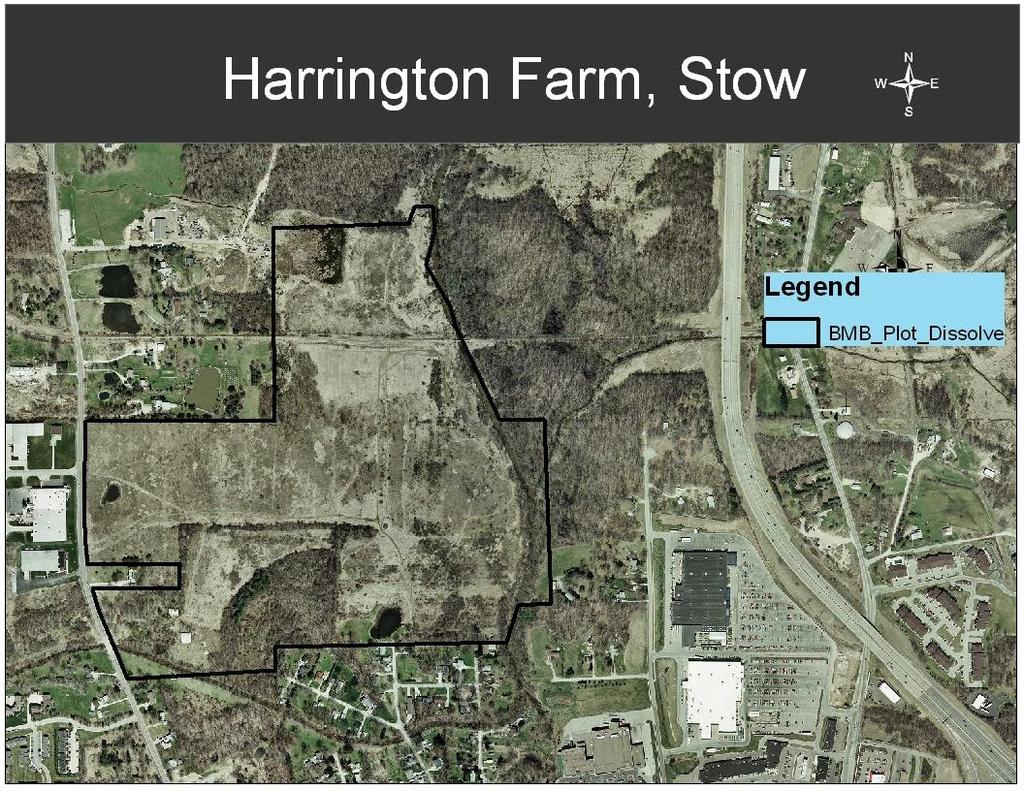
4 Harrington Farm Site Future zoning changes by the city indicate their desire to develop the sight for Industrial use. Site: labeled G
5 Is there a need for Manufacturing in Summit County? % of Total Economy Manufacturing 9.1% Commercial 27.2% Economic Profile Summit County, Ohio Code Type of Industry Number of Industries Percent ages 3Manufacturing % 4Retail Trade % Real Estate, Information, Professional 5and Administrative Services % 6Educational, Health, Social Assistance % 7Arts, Entertainment, Food Industry % 8Other Services, Maintenance % Total
6 Is there a need for Manufacturing in Stow? % of Total Economy Manufacturing Basic 5% Retail Trade Non-basic 27% Real Estate, Information, Professional - Non-basic 30% Educational, Health, Social Assistance - Non-basic 16% Arts, Entertainment, Food Industry Basic 12% Other Services, Maintenance - Non-basic 11% Code Type of Industry # of establishments % Type 3Manufacturing Basic 4Retail Trade Non Basic Real Estate, Information, Professional 5and Administrative Services Non Basic 6Educational, Health, Social Assistance Non Basic 7Arts, Entertainment, Food Industry Basic 8Other Services, Maintenance Non Basic
7 What type of manufacturing would make sense? -Because 1/3 of stow s industry is polymer based, it might make sense to take advantage of this already established base - Stow has a relatively low % of medical industry, yet is located between the renowned Cleveland Clinic and the growing Akron medical corridor it might make sense to take advantage of this location to produce medical supplies Industry by type - Stow Polymers, Plastics & Chemicals % Metals, Machining % Instruments & Controls % Medical % Other % Total Industrial Companies %
8 Population Cohort Male Female Under 5 years 18,417 17,585 5 to 9 years 19,890 19, to 14 years 19,702 18, to 19 years 18,311 17, to 24 years 15,259 15, to 29 years 16,837 17, to 34 years 18,872 19, to 39 years 20,934 22, to 44 years 21,993 23, to 49 years 20,183 21, to 54 years 17,811 18, to 59 years 12,433 13, to 64 years 10,005 11, to 69 years 8,840 10, to 74 years 8,783 11, to 79 years 6,884 11, to 84 years 3,930 6, ,392 males of working age 151,135 females of working age 295,527 working age persons in Stow 85 to 89 years 1,724 4,048
9 % of total Population # of population Attainment Both Sexes Male Female H.S. or less 36.1% 42.9% 49.1% Some college credit, less than 1 year 1 or more years of college, no degree Associate degree Bachelors Degree Masters Degree Professional Degree Doctorate Degree Attainmen t Both Sexes Male Female H.S. or less 173,581 78,314 95,267 Some college credit, less than 1 year 1 or more years of college, no degree Associate degree Bachelors Degree Masters Degree Professiona l Degree Doctorate Degree 26,045 11,542 14,503 52,763 24,998 27,765 19,160 7,974 11,186 60,675 30,469 30,206 20,230 9,815 10,415 6,808 4,453 2,355 3,383 2, In October of 2009 Summit County had an unemployment rate of 9.8% 57.8% have no college degree 252,389 have no college degree
10 Population Cohort at 5 year Interval for the year 2000 Population Cohort Male Female Source: 2000 Census 8,850 males of working age 9,402 females of working age 18,252 working age persons in Stow

11 % of Total Population # of Total Population Attainment Both Sexes Male Female Attainment Both Sexes Male Female H.S. or less 35.8% 34.4% 37.1% H.S. or less 7,656 3,463 4,193 Some college credit, less than 1 year Some college credit, less than 1 year 1, or more years of college, no degree or more years of college, no degree 3,241 1,503 1,738 Associate degree Associate degree 1, Bachelors Degree Bachelors Degree 5,097 2,489 2,608 Masters Degree Masters Degree 1, Professional Degree Professional Degree Doctorate Degree Doctorate Degree % have no college degree 12,260 have no college degree


12 Top: To the northwest of the site, in Cuyahoga Falls. The intersection is Wyoga Lake and Remington Roads. Bottom left: A house immediately to the south of the site, located on the Cuyahoga Falls side of the Stow-Cuyahoga Falls border. Bottom right: To the southwest of the site, also in Cuyahoga Falls. The road is also Wyoga Lake Road. Notice how the power lines are operated by Cuyahoga Falls Municipal Power and not FirstEnergy.


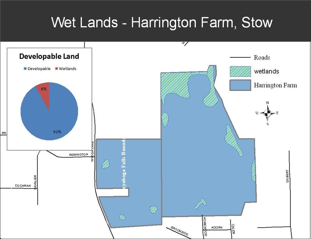
13 Top: Through the trees are the newly-built Wyndham Ridge Apartments to the north of the site. To the east and northeast of the site are wetlands which are not included in this analysis, as they lie outside the property. Bottom: To the southeast of the site is a partiallyobscured home, likely on Homewood Avenue.


14 Top: Mud Brook from the structurallyunstable former railroad bridge. Bottom right: A field is somewhat plowed, leading up to the former railroad tracks. Bottom left: A trail runs through the hilly, fieldcovered landscape.


15 Left: The aforementioned railroad bridge, which won t serve much use to any proposed development in the area. Right: Water lines on the Cuyahoga Falls side of the property.
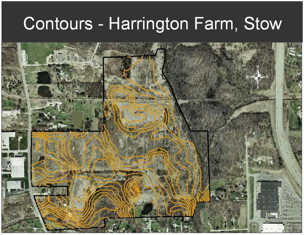
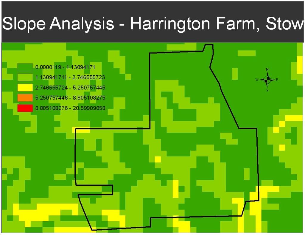
16 Slope Proximity to major roads Proximity to Freeways Sewer connection feasibility Needed sewer line length On-site effluent sewage disposal Municipal water connection feasibility Needed municipal water line length Wetlands Floodplains Soil: suitability Soil: weight carrying capacity Soil: impervious surface suitability Traffic Impact Economic impact Weight and Grade assigned for Residential, Commercial and Industrial development

17

18

19
20

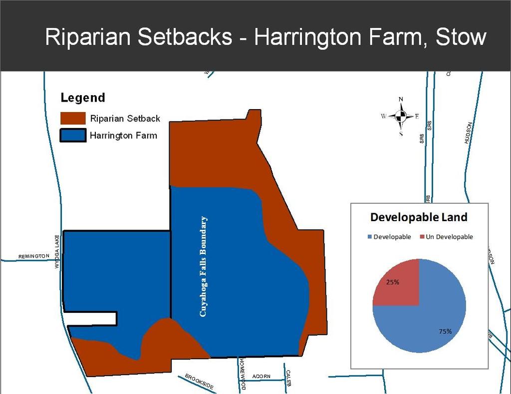
21

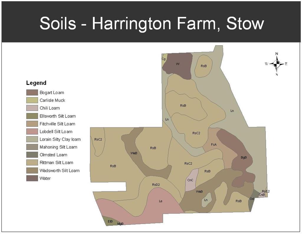
22 RsB = Rittman silt loam: SEVERE limitations for onsite sewage effluent disposal due to slow permeability, moderate limitations for homes of 3 stories or less and streets and parking lots due to a seasonally high water table. RsC2 = Rittman silt loam: SEVERE limitations for onsite sewage effluent disposal due to slow permeability, moderate limitations for homes of 3 stories or less due to seasonally high water table and slope, and severe limitation for streets and parking lots due to slope. BgB = Bogart loam: moderate limitations for onsite sewage effluent disposal, homes of 3 stories or less, and streets and parking lots due to a seasonally high water table. WaB = Wadsworth silt loam: SEVERE limitations for onsite sewage effluent disposal and homes of 3 stories or less due to slow permeability and a seasonally high water table, and moderate limitation for streets and parking lots due to seasonally high water table and slope. CnC = Chili loam: moderate limitations for onsite sewage effluent disposal and homes of 3 stories or less due to slope, and SEVERE limitations for streets and parking lots due to slope. *RsD2 = Rittman silt loam *FcA = Fitchville silt loam *Le = Lobdell silt loam *Ln = Lorain silty clay loam *Cg = Carlisle Muck *= not recommended for development of any type due to severe limitations as well as proximity to floodplain boundary.
 Waterlines on site Sewer lines on")
23 Sewer Costs Cost per foot $ Manhole - $3,ooo (needed every 300ft) Waterline Costs Cost per Foot - $150 Hookup - $2,200 (per house/building) Waterlines on site Sewer lines on site


24 Harrington Farm site is within 30 minutes of N. Canton and well into southeast Cleveland

25 Harrington Farm site is within 5 minutes of Route 8 and within 15 minutes of downtown Akron and I-77
26 The 39 acres of the parcel that is zoned as R-3 will allow up to 3.3 dwellings per acre. The 10 acres zoned R-2 will allow 2.5 dwellings per acre. The entire 49 acre parcel will allow for 153 residential units to be developed. 153 new will result in 1,450 additional trips which must be accommodated by the local road network
27 A commercial development will allow 23% of the 49 acres to be developed, resulting in a development of acres, which is 490,000 square feet. The average shopping center in the US has 56,000 square feet of retail floor space. A commercial center of 100,000 square feet could allow a greater diversity of commercial development and was used for this analysis. A 100,000 Sq ft commercial development will result in 6,700 additional trips which must be accommodated by the local road network.
28 The proposed zoning in Stow will allow for 40% of the 49 acres to be developed for industrial use, resulting in 19.6 acres. The current zoning in Cuyahoga Falls will allow for 50% of the 28 acres to be developed, resulting in 14 additional acres. Total developable land is 34.6 acres. Our proposal is for a 400,000 sq ft industrial development. This does not include space for warehouses and truck parking. This size development will result in 2,700 additional trips which must be accommodated by the local road network
29

30 Residential: 3.3 moderately suitable Commercial: 3.1 moderately suitable Industrial: 3.5 Most suitable of tested development types : Least suitable : Less suitable : Moderately suitable : More suitable 4.2-5: Most suitable
 -Is within a 30")


31 -Will augment the low (5%) basic economy of Stow -Will add only moderate increase in traffic to local road network -Is ideally located for easy freeway access (within 5 min of Route 8) -Is within a 30 minute drive of both Cleveland and the northern edge of Canton -Has potential to augment and benefit from other regional industries -Has already been established as a good use for the site by both Stow and Cuyahoga Falls -Will require little with regards cost site grading, sewer and water connections -Area provides a working age population to support a manufacturing facility -Was the highest rated use in our ranking system
SECTION 5. Existing Conditions TRANSPORTATION NETWORK TRANSPORTATION
 SECTION 5 TRANSPORTATION Transportation systems are vital for moving people and goods and serving existing businesses. They also play a major role in guiding the location and type of development. The following
CHAPTER 7 PHYSICAL INVENTORY OF THE CITY
 CHAPTER 7 PHYSICAL INVENTORY OF THE CITY Chapter 7: Physical Inventory of the City 39 This page intentionally left blank. Chapter 7: Physical Inventory of the City 40 SECTION 1 PHYSICAL SETTING While communities
SITING YORETOWN S NEW LANDFILL INFORMATIONAL SHEET
 SITING YORETOWN S NEW LANDFILL INFORMATIONAL SHEET Yoretown has a solid waste disposal problem. The landfill used for the disposal of its solid waste is near maximum capacity. Since Yoretown is so far
WOO-SR Feasibility Study (PID 90541) Feasibility Study Report April 22, 2011
 Feasibility Study Report April 22, 2011") TABLE OF CONTENTS EXECUTIVE SUMMARY... 1 CHAPTER 1: INTRODUCTION... 5 1.1 Study Purpose and background... 5 1.2 Study Approach... 6 1.3 Study Area... 6 CHAPTER 2: DESCRIPTIONS OF ALTERNATIVES... 7 2.1
TABLE OF CONTENTS EXECUTIVE SUMMARY... 1 CHAPTER 1: INTRODUCTION... 5 1.1 Study Purpose and background... 5 1.2 Study Approach... 6 1.3 Study Area... 6 CHAPTER 2: DESCRIPTIONS OF ALTERNATIVES... 7 2.1
RECREATIONAL FARM FOR SALE acres in Sangamon County, Illinois
 320 S. Crossing Dr. P. O. Box 169 Sherman, IL 62684 217-496-3500 RECREATIONAL FARM FOR SALE 211. 42 acres in Sangamon County, Illinois Located five miles east of Springfield, Illinois In the middle of
Review Zone Application for D&R Canal Commission Decision
 Review Zone Application for D&R Canal Commission Decision MEETING DATE: January 18, 2017 DRCC #: 16-3020C Latest Submission Received: January 10, 2016 Applicant: PVP Franklin, LLC 769 Northfield Avenue,
DEVELOPMENT REPORT UNION PACIFIC PROPERTY SAN ANTONO INTERMODAL YARD AREA
 DEVELOPMENT REPORT UNION PACIFIC PROPERTY SAN ANTONO INTERMODAL YARD AREA This report was prepared to present development information (Utility availability, Development Regulations, Flood Plain information,
Chapter Six Future Transportation and Land Use
 Chapter Six Future Transportation and Land Use Master Thoroughfare Plan Purpose The purpose of the Master Thoroughfare Plan is to determine the size and distribution of the roadway network, taking into
3.12 LAND USE AND PLANNING
 3.12 LAND USE AND PLANNING 3.12.1 INTRODUCTION This section describes the existing land uses in the project vicinity that could be affected by implementation of the Proposed Action and the alternatives.
Hillsborough County Future Land Use 160
 RURAL-AGRICULTURE LAND USE CLASSIFICATION Agricultural/Mining -1/20 (AM-1/20) RESIDENTIAL GROSS DENSITY TYPICAL USES MAXIMUM FLOOR AREA RATIO OR Up to 1 dwelling unit per 20 gross acres. Alternative methods
ADDITION OF VIABLE AGRICULTURAL LANDS
 ADDITION OF VIABLE AGRICULTURAL LANDS NEW YORK STATE CERTIFIED AGRICULTURAL DISTRICTS ONONDAGA COUNTY Onondaga County Agricultural and Farmland Protection Board February 2011 ONONDAGA COUNTY AGRICULTURAL
PLANNING COMMISSION WORKSESSION: MARCH 20, 2011
 STAFF PERSONS: ECHOLS, SORRELL, WEAVER PLANNING COMMISSION WORKSESSION: MARCH 20, 2011 CPA 2013-00001 COMPREHENSIVE PLAN REVISION Worksession 6 Industrial Land Inventory, Rural Interchanges, and Locations
If you have any questions about the request for proposal, please contact me by at
 Cuyahoga County Land Reutilization Corp. 323 W. Lakeside Avenue, Suite 160 Cleveland, Ohio 44113 Tel (216) 698-8853 Fax (216) 698-8972 October 23, 2017 RE: Request for Development Proposals 14501 Kinsman
Chapter 6 Transit 2025 Sketch Plan ---Long Range Plan Project Elements
 Chapter 6 Transit 2025 Sketch Plan ---Long Range Plan Project Elements This chapter presents the Transit 2025 Sketch Plan as a summary of the current and proposed future elements of the RTA transit system
Rezoning Petition Final Staff Analysis July 16, 2018
 Rezoning Petition 2018-038 Final Staff Analysis July 16, 2018 REQUEST Current Zoning: I-1 AIR (light industrial, airport noise overlay) Proposed Zoning: I-2 AIR (general industrial, airport noise overlay)
APPENDICES. Table 46: Quantified Objectives (October 2013 to October 2021) New Construction Rehabilitation Conservation/Preservation
 New Construction Rehabilitation Conservation/Preservation") VI. APPENDICES APPENDIX A. QUANTIFIED OBJECTIVES The City of Placerville has established quantified (numerical) objectives for several program categories to provide measurable standards for monitoring
VI. APPENDICES APPENDIX A. QUANTIFIED OBJECTIVES The City of Placerville has established quantified (numerical) objectives for several program categories to provide measurable standards for monitoring
BACKGROUND INFORMATION DEVELOPMENT COST CHARGE BYLAW REVIEW & UPDATE
 BACKGROUND INFORMATION DEVELOPMENT COST CHARGE BYLAW REVIEW & UPDATE On April 29, 2013 the District of North Vancouver adopted a new DCC bylaw containing new rates that become effective November 1, 2013.
CITY OF SUSANVILLE PLANNING DIVISION PROJECT & ENVIRONMENTAL QUESTIONNAIRE
 This form is available on line at www.cityofsusanville.org CITY OF SUSANVILLE PLANNING DIVISION PROJECT & ENVIRONMENTAL QUESTIONNAIRE This document will assist the Planning Divisions evaluation of the
The Little Canada Comprehensive Plan consists of the following sections:
 INTRODUCTION Comprehensive Plan Overview The City of Little Canada, in response to local needs and Minnesota State Statute requirements, is updating its Comprehensive Plan. The primary purpose of this
Article 7. COMMERCIAL AND MIXED USE ZONES
 COMMERCIAL AND MIXED USE ZONES 24-21 Article 7. COMMERCIAL AND MIXED USE ZONES Sections: 24-21 Purpose of the Commercial and Mixed Use s 24-22 Land Use Regulations for Commercial and Mixed Use s 24-23
SECTION 3 NATURAL RESOURCES
 SECTION 3 NATURAL RESOURCES The natural environment plays a large role in planning for future development. Environmental conditions, such as topography, wetlands, floodplains, and water bodies, can often
WQMP AMENDMENT REVIEW CHECKLIST
 State of New Jersey Highlands Water Protection and Planning Council 100 North Road (Route 513) Chester, New Jersey 07930-2322 (908) 879-6737 (908) 879-4205 (fax) www.highlands.state.nj.us WQMP AMENDMENT
Notwithstanding article VII of this chapter, the following conditional uses may be permitted in the planned mixed use development (PMUD) zone:
 zone:") DIVISION 14. - PLANNED MIXED USE DEVELOPMENT (PMUD) Sec. 78-1021. - Purpose. The town is a community with a rich tradition of mixed use neighborhoods and a paucity of land area dedicated for large commercial,
DIVISION 14. - PLANNED MIXED USE DEVELOPMENT (PMUD) Sec. 78-1021. - Purpose. The town is a community with a rich tradition of mixed use neighborhoods and a paucity of land area dedicated for large commercial,
WRIGHT CODE parking and/or storage shall be permitted in the buffer area.
 145-506 WRIGHT CODE 145-507 parking and/or storage shall be permitted in the buffer area. (f) In addition, commercial lighting shall be directed away from adjoining and/or abutting properties. E. Supplementary
5 ALTERNATIVES TO THE PROPOSED PROJECT
 5 ALTERNATIVES TO THE PROPOSED PROJECT 5.1 INTRODUCTION In accordance with Section 15126.6(a) of the State California Environmental Quality Act (CEQA) Guidelines, an environmental impact report (EIR) must
SECTION 3.322: NESKOWIN LOW DENSITY RESIDENTIAL ZONE (NeskR-1)
") SECTION 3.322: NESKOWIN LOW DENSITY RESIDENTIAL ZONE (NeskR-1) (1) PURPOSE: The purpose of the NeskR-1 zone is to designate areas for lowdensity single-family residential development and other, compatible,
SECTION 3.322: NESKOWIN LOW DENSITY RESIDENTIAL ZONE (NeskR-1) (1) PURPOSE: The purpose of the NeskR-1 zone is to designate areas for lowdensity single-family residential development and other, compatible,
State Route 8 Bridge Replacement Project
 OPEN HOUSE PUBLIC INVOLVEMENT MEETING Celebration Church 688 Dan Street, Akron, Ohio Tuesday, July 14, 2015 5:00 PM to 7:00 PM State Route 8 Bridge Replacement Project Existing Bridge Future Bridges: Steel
10384 Navarre Road SW Navarre, Ohio 44662
 For Sale 32,084/SF Industrial PRICE D REDUCE 10384 Navarre Road SW 44662 Don Bester, Vice President 330 966 8800 ext. 302 don@ NO WARRANTY OR REPRESENTATION, EXPRESS OR IMPLIED, IS MADE AS TO THE ACCURACY
SANTA BARBARA COUNTY ZONING ADMINISTRATOR STAFF REPORT October 21, 2011
 SANTA BARBARA COUNTY ZONING ADMINISTRATOR STAFF REPORT October 21, 2011 PROJECT: Gilson Move Dwelling HEARING DATE: November 7, 2011 STAFF/PHONE: J. Ritterbeck, (805) 568-3509 GENERAL INFORMATION Case
CHAPTER 8: INTERGOVERNMENTAL COOPERATION
 CHAPTER 8: INTERGOVERNMENTAL COOPERATION Photos above by Randy Uhl 8.1 Introduction Intergovernmental cooperation involves working with neighboring communities, school districts and agencies to understand
12 Evaluation of Alternatives
 12 Evaluation of Alternatives This chapter evaluates the effectiveness of the No-Build Alternative and the proposed METRO Blue Line Light Rail Transit (BLRT) Extension project based on the information
STAFF REPORT. Planning Commission. Anjanette Simon, Associate Planner
 STAFF REPORT TO: Planning Commission HEARING DATE: May 23, 2012 FROM: APPLICATIONS: LOCATION: Anjanette Simon, Associate Planner ZMA2012-0005 (158th and Baseline Station Community High Density Residential
3.8 LAND USE AND PLANNING
 3.8 LAND USE AND PLANNING 3.8.1 INTRODUCTION This section evaluates the potential land use and planning impacts of the proposed project. The section describes the existing and surrounding land uses at
COMPREHENSIVE PLAN Executive Summary C ITY OF ENNIS, TEXAS
 COMPREHENSIVE PLAN 2000-2020 Executive Summary CITY OF ENNIS, TEXAS COMPREHENSIVE PLAN 2000 2020 EXECUTIVE SUMMARY! The Future Land Use Plan! Public Facilities Plan (Map) Table of Contents! Parks, Recreation
Municipal Class EA Process
 Purpose of Tonight s Meeting INTRODUCTION This is the first Public Information Centre (PIC) to present information on the Class Environmental Assessment (EA) Study for a new operations centre. The following
ARTICLE 9 INDUSTRIAL
 ARTICLE 9 INDUSTRIAL Sec. 29.900. INDUSTRIAL BASE ZONES. (1) Purpose. The industrial base zones established by this Ordinance are General Industrial (GI) Zone and Planned Industrial (PI) Zone. Each of
Environmental and Development Services Department Planning Division San Pablo Avenue, El Cerrito, CA (510) FAX: (510)
 FAX: (510)") Environmental and Development Services Department Planning Division 10890 San Pablo Avenue, El Cerrito, CA 94530 (510) 215-4330 - FAX: (510) 233-5401 N O T I C E O F P R E P A R A T I O N DATE: April 4,
Environmental and Development Services Department Planning Division 10890 San Pablo Avenue, El Cerrito, CA 94530 (510) 215-4330 - FAX: (510) 233-5401 N O T I C E O F P R E P A R A T I O N DATE: April 4,
XI. Thornton Planning Area
 XI. A. OVERVIEW The covers 120 square miles in the northwest corner of San Joaquin County. It consists primarily of low-lying Delta islands, sloughs, and large farms. The town of Thornton, a small agriculturally-based
Downtown Cuyahoga Falls Circulation & Economic Transformation Project 2016 TIGER GRANT
 Downtown Cuyahoga Falls Circulation & Economic Transformation Project 2016 TIGER GRANT APRIL 14, 2016 4/18/2016 CUYAHOGA FALLS CITY COUNCIL COMMITTEE MEETING 1 Tiger Grant Overview 4/18/2016 CUYAHOGA FALLS
NOBLESVILLE PLAN COMMISSION STAFF REPORT DECEMBER 16, 2013
 #1 NOBLESVILLE PLAN COMMISSION STAFF REPORT DECEMBER 16, 2013 13W-14-2137 (6204) & 13N-15-2030 (6193) Change of zoning from A2-S Agricultural Subdivision (Hamilton County) to R-1 Low Density Single Family
Town of Bristol Town Administrator 1 South Street P.O. Box 249 Bristol, VT (802) x22
 x22") Town of Bristol Town Administrator 1 South Street P.O. Box 249 Bristol, VT 05443 (802) 453-2410 x22 townadmin@bristolvt.org www.bristolvt.org March 29, 2019 Northern Border Regional Commission Economic
Town of Bristol Town Administrator 1 South Street P.O. Box 249 Bristol, VT 05443 (802) 453-2410 x22 townadmin@bristolvt.org www.bristolvt.org March 29, 2019 Northern Border Regional Commission Economic
Once known as warehousing and distribution, the process
 Map III-2.3 Proposed Agile Port Industrial Area AGILE PORT INDUSTRIAL AREA PLAN Once known as warehousing and distribution, the process of moving goods to market has evolved dramatically. No longer is
Stantec LAKEW OD RANCH STEWARDSHIP DISTRICT MASTER ENGINEER'S REPORT FOR NORTHEAST SECTOR AT LAKEWOOD RANCH INFRASTRUCTURE IMPROVEMENTS
 LAKEW OD RANCH STEWARDSHIP DISTRICT MASTER ENGINEER'S REPORT FOR NORTHEAST SECTOR AT LAKEWOOD RANCH INFRASTRUCTURE IMPROVEMENTS Stantec Prepared for: Lakewood Ranch Stewardship District 14400 Covenant
3 PROJECT DESCRIPTION
 3.1 PROJECT OVERVIEW 3 PROJECT DESCRIPTION The Rocklin 60 project (proposed project) includes the subdivision of 56.9 acres of land, construction of 179 single-family, detached dwelling units, and installation
Project Plan for TAX INCREMENTAL FINANCE DISTRICT #41 (UNIVERSITY-WHITNEY) City of Madison
 City of Madison") Project Plan for TAX INCREMENTAL FINANCE DISTRICT #41 (UNIVERSITY-WHITNEY) City of Madison Prepared by: Department of Planning and Community and Economic Development Economic Development Division Office
Project Plan for TAX INCREMENTAL FINANCE DISTRICT #41 (UNIVERSITY-WHITNEY) City of Madison Prepared by: Department of Planning and Community and Economic Development Economic Development Division Office
TES Industrial Development SW ¼ SEC Lacombe County Outline Plan
 TES Industrial Development Lacombe County Outline Plan 112849297 June 2012 am v:\1128\active\112849297\07_reports_studies\rpt_tes_20120508.doc i Table of Contents 1.0 INTRODUCTION... 1 1.1 PURPOSE... 1
Appendix A SUMMARY OF EXISTING ZONING DISTRICTS FOR THE CIVIL DIVISIONS ADJACENT TO THE VILLAGE OF HARTLAND AND WITHIN THE STUDY AREA: 1998
 Appendix A SUMMARY OF EXISTING ZONING DISTRICTS FOR THE CIVIL DIVISIONS ADJACENT TO THE VILLAGE OF HARTLAND AND WITHIN THE STUDY AREA: 1998 The following tables are summaries of existing zoning ordinances
CHAPTER 6 SANITARY SEWER SUB-ELEMENT
 CHAPTER 6 SANITARY SEWER SUB-ELEMENT Page 1 of 10 CHAPTER 6 SANITARY SEWER SUB-ELEMENT A. OVERVIEW The following Future Land Use categories are considered to be urban and require the provision of sanitary
Fairfield Corporate Commons
 Campus Ln. Kaiser Dr. SACRAMENTO ±30 mi Business Center Dr. Mangels Blvd. NAPA (HWY 12) ±1 mi Suisun Valley Rd. SAN FRANCISCO ±0 mi CONCORD (I-6) ±21 mi Fairfield Corporate Commons ±36.9 Acres of Land
Town of Hartford. Comprehensive Planning Visioning Workshop. Results. November 17, 2006
 Town of Hartford Comprehensive Planning Visioning Workshop Results November 17, 2006 Workshop Conducted: September 19, 2006 Hartford Town Hall 37 Participants Station # Station Title 2 Mapping Future Residential
17. WATER SUPPLY. TABLE 17.1 Average Daily Potable Water Demand
 17. WATER SUPPLY A. 1. Provide a projection of the average daily potable and non-potable water demands at the end of each phase of development. If significant seasonal demand variations will occur, discuss
Centerpoint of the Southwest
 Casa Grande, Arizona 17 8 Phoenix Casa Grande SUN CORRIDOR MEGAREGION Runs nearly 300 miles from Prescott, AZ to northern Sonora, Mexico with Casa Grande at the center point of the Megaregion. SUN CORRIDOR
2 COMMUNITY P. average number of days with any measurable precipitation is 112. On average, there are 205 sunny days per year
 2 COMMUNITY P PROFILE Chapter 2 provides a profile of the City of Forest Hills planning area and identifies capabilities already in place in the city to help mitigate hazards addressed in this plan. 2.1
SEPA Modification Application
 SEPA Modification Application 6000 Main St. SW, Lakewood, WA 98499 Phone: (253) 512-2261 Application Fee: $200.00 Technology Fee: $4.00 Number of Copies Required: Description of Required Documents: Required:
New York State Department of Environmental Conservation August Receive Site Fact Sheets by . See "For More Information" to Learn How.
 New York State Department of Environmental Conservation August 2013 FACT SHEET Environmental Restoration Program Receive Site Fact Sheets by Email. See "For More Information" to Learn How. Site Name: 1201
DESIGN REVIEW COMMITTEE AGENDA ITEM
 DESIGN REVIEW COMMITTEE AGENDA ITEM AGENDA DATE: MAY 1, 2013 TO: THRU: FROM: SUBJECT: Chair Fox and Members of the Design Review Committee Leslie Aranda Roseberry, Planning Manager Jennifer Le, Senior
ARTICLE II Zoning Districts and Allowable Land Uses
 ARTICLE II Zoning Districts and Allowable Land Uses Chapter 18.06 - Establishment of Zoning Districts, Adoption of Zoning Map...II-3 18.06.010 - Purpose of Chapter... II-3 18.06.020 - Zoning Districts
BASIS OF REVIEW SITE PLAN REVIEW
 Sheila Page, Town Planner Town of Ashland 101 Main Street Ashland, Massachusetts 01721 Re: 0 Tri Street - Peer Review Dear Ms. Page and Members of the Board: Professional Services Corporation, PC (PSC)
ENVIRONMENTAL FEATURES OF THE TOWN
 Town of Aurora Map 1 11 12 ENVRONMENTAL FEATURES TOPOGRAPY Maps 1 and 2 show the locations of important natural features of the Town of Aurora. Aurora is located in the Alleghany Plateau, a region of broad,
Rules for providing public testimony
 Rules for providing public testimony Allow speaker to be heard do not speak over the speaker. Court reporter can only record one topic of the West Waukesha Bypass Study. All speakers will be allowed 3
APPENDICES. Table 46: Quantified Objectives (October 2013 to October 2021) New Construction Rehabilitation Conservation/Preservation
 New Construction Rehabilitation Conservation/Preservation") VI. APPENDICES APPENDIX A. QUANTIFIED OBJECTIVES The City of Placerville has established quantified (numerical) objectives for several program categories to provide measurable standards for monitoring
VI. APPENDICES APPENDIX A. QUANTIFIED OBJECTIVES The City of Placerville has established quantified (numerical) objectives for several program categories to provide measurable standards for monitoring
Seasons Business Center New Construction!
 Seasons Business Center New Construction!...Seasons Business Center Stow, Ohio 114,188 SF of High Bay Space 32 Clear Height 80 480 ESFR Sprinklers Tax Abatement Available 8 Reinforced Concrete Floor 271
9-LOT SUBDIVISION & PUD SKETCH PLAN
 9-LOT SUBDIVISION & PUD SKETCH PLAN Owner: Wind Energy Associates & Jan Blomstrann 110 Riggs Road, Hinesburg, VT 05461 Surveyor/Engineer: Maclay Architects Applicant: same Property Tax Parcel: 16-20-56.900
Chapter 7: Sanitary Sewer Plan. Introduction. Metropolitan Council Coordination
 Chapter 7: Sanitary Sewer Plan Introduction The 2030 Sanitary Sewer Plan was prepared for two primary reasons. The first purpose is to provide recommendations and guidance to the City of Lino Lakes by
64E System Size Determinations.
 64E-6.008 System Size Determinations. (1) Minimum design flows for systems serving any structure, building or group of buildings shall be based on the estimated daily sewage flow as determined from Table
Property Owner's Name: Telephone #: Mailing Address: System Address (if different): Directions to location of installation:
: Directions to location of installation:") SANGAMON COUNTY DEPARTMENT OF PUBLIC HEALTH Environmental Health Division 2833 S. Grand Ave. East Springfield, Illinois 62703 Phone: (217) 535-3145 Fax: (217) 747-5103 envhealth@co.sangamon.il.us, website
SANGAMON COUNTY DEPARTMENT OF PUBLIC HEALTH Environmental Health Division 2833 S. Grand Ave. East Springfield, Illinois 62703 Phone: (217) 535-3145 Fax: (217) 747-5103 envhealth@co.sangamon.il.us, website
Include this form in your application submittal.
 PRE-APPLICATION FORM PLEASE NOTE: A pre-application conference is required prior to submittal on all applications. The purpose of the pre-application conference is to determine if the application is ready
Marcellus Shale Follow-up Questions. Sue Mukherjee, Director Center for Workforce Information & Analysis Pennsylvania Department of Labor & Industry
 Marcellus Shale Follow-up Questions Sue Mukherjee, Director Center for Workforce Information & Analysis Pennsylvania Department of Labor & Industry 1 Follow-up (from 4/14/2011) 1. Ancillary does it include
PLANNING COMMISSION STAFF REPORT
 PLANNING COMMISSION STAFF REPORT MEETING DATE: April 18, 2019 PROJECT NUMBER: C-19-002 REQUEST: Conditional Use Permit to increase the height of an existing freeway-oriented billboard, increase the sign
If you have any questions, feel free to contact the office of the Planning Commission at
 Attention: Enclosed, is an application for a zoning permit for the Townships of Amboy, Franklin, Fulton & York. You may return your application and check made payable to: ZONING FEES Fulton County Regional
MINUTE ORDER. BONNER COUNTY PLANNING and ZONING COMMISSION PUBLIC HEARING MINUTES JANUARY 14, 2016
 MINUTE ORDER BONNER COUNTY PLANNING and ZONING COMMISSION PUBLIC HEARING MINUTES JANUARY 14, 2016 CALL TO ORDER: Chair Temple called the Bonner County Planning and Zoning Commission hearing to order at
Seasons Business Center 2 New Construction!
 Seasons Business Center 2 New Construction!...542 Seasons Rd. Stow, Ohio 114,188 SF of High Bay Space 32 Clear Height 80 480 ESFR Sprinklers 8 Reinforced Concrete Floor Abundant Parking Floor Plans to
PERMITTED USES: Within the MX Mixed Use District the following uses are permitted:
 6.24 - MX - MIXED USE DISTRICT 6.24.1 INTENT: The purpose of the MX Mixed Use District is to accommodate the development of a wide-range of residential and compatible non-residential uses (including major
SITE EVALUATION REQUEST FORM
 State of Ohio Environmental Protection Agency SITE EVALUATION REQUEST FORM FOR SEWAGE AND OTHER WASTEWATER DISPOSAL SYSTEMS IN AREAS NOT SERVED BY PUBLIC SANITARY SEWERS The enclosed form should be completed
System Address (if different): Directions to location of installation:
: Directions to location of installation:") MENARD COUNTY PUBLIC HEALTH c/o SANGAMON COUNTY PUBLIC HEALTH 2833 S. Grand Ave. East Springfield, Illinois 62703 Phone: (217) 535-3145 Fax: (217) 747-5103 Permit Fee: $275.00 Permit #: Issued: Expiration
MENARD COUNTY PUBLIC HEALTH c/o SANGAMON COUNTY PUBLIC HEALTH 2833 S. Grand Ave. East Springfield, Illinois 62703 Phone: (217) 535-3145 Fax: (217) 747-5103 Permit Fee: $275.00 Permit #: Issued: Expiration
2.1 Summary of Existing and Future Population Estimates
 SECTION 2 Demographics This technical memorandum identifies the uncertainties and describes potential future demographics that might affect wastewater facilities in the City of McCall, Idaho (the City).
VII. WATER SUPPLY AND SEWAGE TREATMENT
 VII. WATER SUPPLY AND SEWAGE TREATMENT Water supply and sewage treatment are essential services accompanying the development of land for housing, non-profit and community institutions, commerce and industry.
Cass County Soil Erosion & Sedimentation Control Program
 Cass County Soil Erosion & Sedimentation Control Program Both residents and visitors of Cass County enjoy the beauty of over 250 lakes and ponds, along with numerous streams, creeks, and wetlands that
2016 MAJOR GENERAL PLAN AMENDMENT
 2016 MAJOR GENERAL PLAN AMENDMENT GROWTH AREAS ELEMENT GROWTH AREAS ELEMENT 4.0 GOALS 1. Encourage orderly development within Growth Areas. 2. Encourage balanced, mixed use and multi-modal development
SOUTHWEST LRT (METRO GREEN LINE EXTENSION)
") 8 Evaluation of Alternatives This chapter evaluates the effectiveness of the No Build Alternative and the Southwest Light Rail Transit (LRT) Project (the Project) based on the information contained in
8 Evaluation of Alternatives This chapter evaluates the effectiveness of the No Build Alternative and the Southwest Light Rail Transit (LRT) Project (the Project) based on the information contained in
BASELINE DOCUMENTATION REPORT
 BASELINE DOCUMENTATION REPORT FOR LAKE FOREST ESTATES MACEDONIA, OHIO SUMMIT COUNTY, OHIO September 15, 2006 January 5, 2007 Prepared for: Lake Forest Estates Homeowner s Association, Inc. c/o TransCon
Application Number: SP Project Name: Novo Nordisk Bright Sky Major Site Plan (acting as a Master Plan)
") STAFF REPORT Town of Clayton Staff Report Planning Department 111 E. Second Street, Clayton, NC 27520 P.O. Box 879, Clayton, NC 27528 Phone: 919-553-5002 Fax: 919-553-1720 Planning Board February 22, 2016
STAFF REPORT Town of Clayton Staff Report Planning Department 111 E. Second Street, Clayton, NC 27520 P.O. Box 879, Clayton, NC 27528 Phone: 919-553-5002 Fax: 919-553-1720 Planning Board February 22, 2016
Chapter 9: Vision Plan. Chapter 9. Vision Plan. Lake Loveland. Image 179 Credit: City of Loveland
 Chapter 9 Vision Plan Lake Loveland. Image 179 Credit: City of Loveland Chapter 9: Vision Plan A. Regionally Significant Corridor and Regional Bike Corridor Visions Corridor visioning seeks to develop
1. Applicant: City of Verona 2. Description of Proposal. 3. Existing Environment
 2/28/05 Staff Analysis of the Proposed Amendment to the Water Quality Plan Revising the Verona Urban Service Area Boundary and Environmental Corridors in the City of Verona 1. Applicant: City of Verona
STAFF REPORT. Permit Number: Tallman. Kitsap County Board of Commissioners; Kitsap County Planning Commission
 STAFF REPORT Permit Number: 15 00742 Tallman DATE: November 9, 2015 TO: FROM: RE: Kitsap County Board of Commissioners; Kitsap County Planning Commission Katrina Knutson, AICP, Senior Planner, DCD and
PROJECT SCOPE OF WORK CITY OF TOWN AND COUNTRY STORMWATER PROGRAM
 PROJECT SCOPE OF WORK CITY OF TOWN AND COUNTRY STORMWATER PROGRAM Project Name: 194 Muir Woods Ln Project ID Number: 216-2 Problem: At 194 Muir Woods Lane, nearly two acres of watershed flow through the
Rezoning Petition Final Staff Analysis June 18, 2018
 Rezoning Petition 2018-021 Final Staff Analysis June 18, 2018 REQUEST Current Zoning: B-1(CD) (neighborhood business, conditional) Proposed Zoning: B-1 (neighborhood business) LOCATION Approximately 0.37
Vision, Goals, Objectives, and Land Use Scenarios Welcome
 Vision, Goals, Objectives, and Land Use Scenarios Welcome Event purpose is to: 1. present draft land use scenarios, as well as the vision, goals and objectives. 2. provide a project update and the next
TOWN OF SMYRNA Water Quality Buffer Zone Policy
 TOWN OF SMYRNA Water Quality Buffer Zone Policy Section I - Description A water quality buffer zone (a.k.a. a riparian zone) is a strip of undisturbed native (indigenous) vegetation, either original or
11 Joint Development Regulatory Context and Methodology
 11 Joint Development This chapter describes the long-term direct and potential indirect impacts, and short-term direct and potential indirect impacts, of the proposed METRO Blue Line Light Rail Transit
Washington Boulevard and Kirkwood Road Special General Land Use Plan (GLUP) Study Plus. Agenda Item #43
 Study Plus. Agenda Item #43") Washington Boulevard and Kirkwood Road Special General Land Use Plan (GLUP) Study Plus Agenda Item #43 County Board Meeting OCTOBER 21, 2017 Subjects Request to Advertise public hearings to Consider the
Washington Boulevard and Kirkwood Road Special General Land Use Plan (GLUP) Study Plus Agenda Item #43 County Board Meeting OCTOBER 21, 2017 Subjects Request to Advertise public hearings to Consider the
Silverdale Water District 2018 Environmental Checklist
 PURPOSE OF THE CHECKLIST: Project Name: Construction Agreement No.: Applicant: Abbreviated Legal Description: Assessor s Tax Parcel ID No.: Please read the following carefully before filling out the checklist.
INDUSTRIAL SITES. Contact Us: A Summary of Industrial Land in the Township of Wellington North
 INDUSTRIAL SITES A Summary of Industrial Land in the Township of Wellington North Contact Us: The Or ecdev@wellington north.com TABLE OF CONTENTS About Wellington North...1 Industrial Land Strategy...2
Northern Tier. Pennsylvania s Marcellus Shale Formation. Population Demographics
 Northern Tier Pennsylvania s Marcellus Shale Formation The Marcellus Shale is a rock formation that underlies much of Pennsylvania and portions of New York, Ohio and West Virginia at a depth of 5,000 to
Appendix A Stormwater Site Plan Report Short Form
 Appendix A Stormwater Site Plan Report Short Form The Stormwater Site Plan Report Short Form may be used for projects that trigger only Minimum Requirements #1-#5. These projects typically fall within
LAND USE INTRODUCTION EXISTING CONDITIONS
 1 2 3 4 5 6 7 8 9 10 11 12 13 14 15 16 17 18 INTRODUCTION This chapter describes land use in the Lemon Creek area using maps and data that show designations of all properties by the 2013 Comprehensive
14(h)EPA-06 City of Springfield 76 East High Street Springfield, Ohio Clark County Greening City Plaza
EPA-06 City of Springfield 76 East High Street Springfield, Ohio Clark County Greening City Plaza") 14(h)EPA-06 City of Springfield 76 East High Street Springfield, Ohio 45502 Clark County Greening City Plaza $100,000 in FY 2014 Section 319(h) Nonpoint Source grant funding is requested to install three
14(h)EPA-06 City of Springfield 76 East High Street Springfield, Ohio 45502 Clark County Greening City Plaza $100,000 in FY 2014 Section 319(h) Nonpoint Source grant funding is requested to install three
SUMMIT COUNTY PLANNING AND ENGINEERING DEPARTMENT SINGLE-FAMILY/DUPLEX BUILDING PERMIT / GRADING AND EXCAVATION PERMITTING INFORMATION PACKET
 SUMMIT COUNTY PLANNING AND ENGINEERING DEPARTMENT SINGLE-FAMILY/DUPLEX BUILDING PERMIT / GRADING AND EXCAVATION PERMITTING INFORMATION PACKET GENERAL INFORMATION The following information explains how
Construction Application for Permit (CAP) Instructions
 Instructions") Construction Application for Permit (CAP) Instructions A CAP is required to be completed and submitted to the Wayne Soil & Water Conservation District (SWCD) office for non-farm, earth-disturbing activities
Construction Application for Permit (CAP) Instructions A CAP is required to be completed and submitted to the Wayne Soil & Water Conservation District (SWCD) office for non-farm, earth-disturbing activities