Suzy Valentine, P.E. Pecos River Commission April 2014
|
|
|
- Edwina Banks
- 5 years ago
- Views:
Transcription


1 Suzy Valentine, P.E. Pecos River Commission April 2014


2 Historical context Background History Update

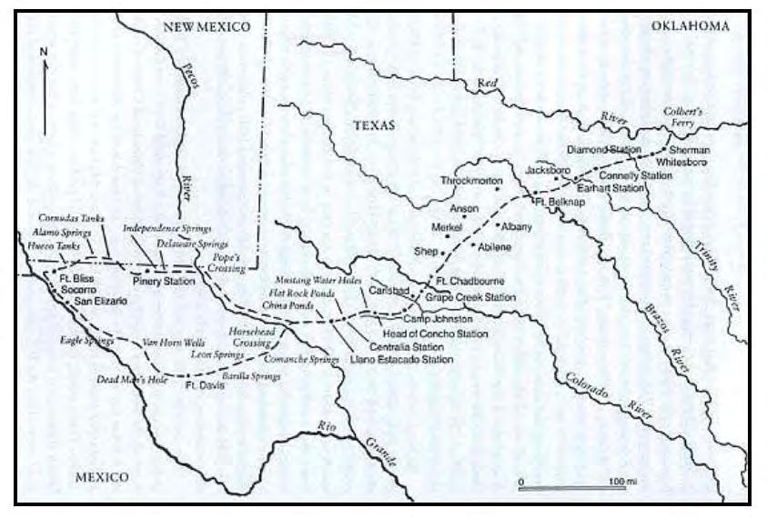
3 Camels crossing a West Texas stream - From a painting by an unknown soldier who may have been with the Echols or Hartz topographical engineering expeditions Same location as Pope s expedition Corps of topographical engineers surveyed and documented hydrographical features Looking for convenient routes west, such as river crossings and water sources


4 Harry S. Sindall, Pope s Artesian Well, c , Collection of The State Preservation Board, Austin, Texas. Captain John Pope s Expedition and Artesian well drilling site Gave up looking for fresh water after 3 years Landmark on Goodnight-Loving Cattle Trail

5
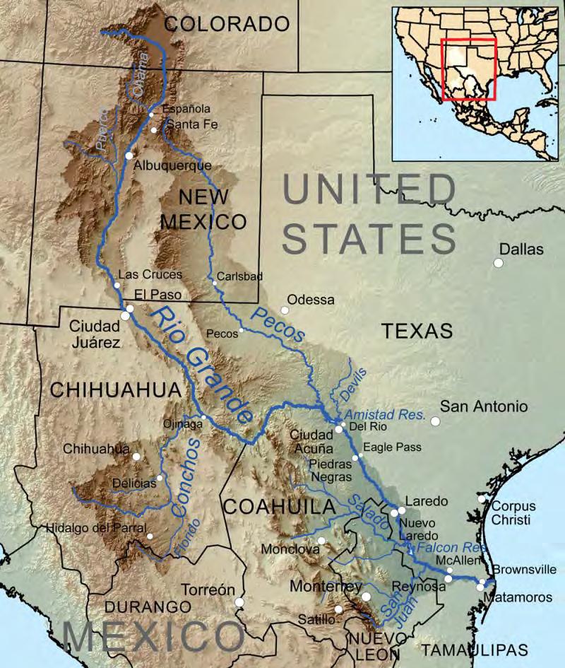
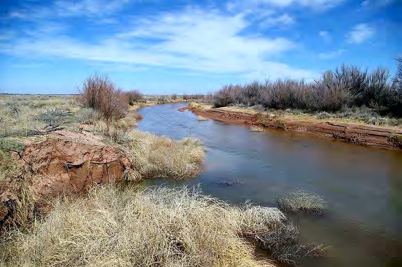
6 Rio de las Vacas Rio Salado Rio Puerco Rio Pecos 929 miles long Over 44,000 square miles drainage area National Wild and Scenic River in headwaters (20.5 mi) Average daily flows (Tx A&M and IBWC) ~90 cfs at Malaga Bend ~33 cfs at Girvin ~265 cfs at Langtry ~222,000 acre feet into Lake Amistad


7

8 Permian period shallow sea million years ago Sea advanced and retreated Formation of evaporite deposits Groundwater dissolution formed collapsed sinkholes Pecos River salt springs Up to ~172,000 tons per year Salinity up to 4,100 ppm As flows declined in river = less dilution made conditions worse from Miyamoto & others (2007)


9 Red Bluff Reservoir Salt loading total = 560,000+ tons per year 478,000 tons per year from Pecos R. 80,000 tons per year from Delaware R. Reservoir Outflow 410,000 tons/year TDS of water = 6,000 ppm Too high for most crops Marginal for livestock Limits biodiversity of species Salinity at Girvin: 12,000 ppm Salt loading for Lake Amistad 26% from Pecos River (<10% flow) Upper limit of drinking water standards from Miyamoto & others (2007-8) Red Bluff Reservoir Lake Amistad

10 from Malaga Bend Experimental Salinity Alleviation Project A Comprehensive Interim Report, Eddy Co., NM, 1970 By John S. Havens, prepared for the USGS in cooperation with the Pecos River Commission
11 PRC was active in sponsoring reports that identified brine discharge near Malaga Bend USGS proposed solution of pumping brine to lower aquifer and reduce discharge 1958 Congress Authorizes Water Salvage Alleviation Project McMillan Delta Salvage Channel Brine pumping at Malaga Bend First salt control project of its kind in the U.S. Construction by Bureau of Reclamation Data collection by USGS Right of way acquired by New Mexico Operation and maintenance by Texas
12 1963: Pumping starts 220 ft well, ~2 miles of pipe Discharge to unlined but compacted 50- acre evaporation pond called Anderson Lake Pumping from 1963 to 1976 By December 1964, 1,000 acre-feet of water pumped removing 300,000 tons of salt Decreased brine inflow to river by 70% About 3,878 acre-feet of brine is pumped 1970, 1976, 1979, 1980: USGS reports with concerns mounting over leakage from disposal lake : Brine pumped to Culberson County (Texas) for enhanced oil recovery (EOR) but stops due to pump and casing problems From Havens, 1970.
13 1992: Private companies propose to pump at Malaga Bend to harvest salt for sale 1993: Pumping stops due to: A need to re-engineer the pond Concerns that pond was hazard to water fowl Lack of interest by United Salt Company to operate facility : Private companies were once again offering proposals to mine salt 2010: Pecos River Water Quality Coalition Forms Coordinate efforts of PRC, lawmakers, stakeholders and Federal and State agencies 2012: Pecos Initial Assessment by U.S. Army Corps of Engineers and conducted by USGS 2013: Southwest Salt Company begins Malaga Bend project 2013: Pecos Watershed Assessment Project Part of Rio Grande Salinity Management Program Non-Federal sponsors: Texas TCEQ and New Mexico ISC Funds provided by Texas Water Development Board Contracts and Agreements signed in March 2014 Kickoff Meeting in May


14 2012: Pecos River Compact Commissioners work with Southwest Salt, a private company, to pump well again to produce salt Carlsbad 2013: Pumping Begins Malaga Bend Red Bluff New Mexico Texas
")
15 Ponds Pump at Well C mile pipeline Three 20-acre evaporation ponds (so far) Processing plant constructed Well

16 Well drilled into brine aquifer in Salado Formation Can produce 250,000 tons of salt per year Would require up to 8 ponds Pond permit from New Mexico Environmental Dept. allows 4 ponds By end of selling salt By end of rate to increase to 6,000 tons per month By mid plan to increase to 90,000 tons per year

17 In 2013, 221 acre feet pumped to ponds 250 gallons per minute 90,000 tons of salt 1 foot of base salt required 1 foot of salt expected per year Salt can be harvested after 18 months

18 Processing facility and equipment Salt for water softening and cattle feed Initial delivery by truck Ultimately delivery by rail
")
 Well Malaga Bend Pierce Canyon")
19 USGS Gages Malaga Bend Pierce Canyon Crossing Water Quality Testing Center of Excellence for Hazardous Materials Management (CEHMM) Twice a month Gain in Total Daily Salt Load < T/day Malaga Bend Gage ( ) Well Malaga Bend Pierce Canyon Crossing Gage ( )
20
21

22 Photos courtesy of Abe Van Luik Thoughts and Places.org, 2011 Pre-project conditions

23

24 Starting to see salt deposits

25


26 Salt Deposits beginning to diminish


27 Left over from last attempt

28 Contact Suzy Valentine, P.E. Pecos River Commission - Texas Texas Commission on Environmental Quality suzy.valentine@tceq.texas.gov
29 Pecos River Commission, Initial Development, Water Salvage and Salinity Alleviation Action Programs, Pecos River Basin. Cox, E.H. and J.L. Kunkler, Feasibility of Injecting Brine from Malaga Bend into the Delaware Mountain, Eddy County, NM. USGS in cooperation with the Pecos River Commission. Havens, J.S., Malaga Bend Experimental Salinity Alleviation Project A Comprehensive Interim Report Eddy County, NM. USGS in cooperation with the Pecos River Commission. Kunkler, J.L. and Havens, J.S., Preliminary Draft - Evaporation and Leakage of Brine from Anderson Lake at Malaga Bend, Eddy County, NM. USGS in cooperation with the Pecos River Commission. Kunkler, J.L., Evaluation of the Malaga Bend Salinity Alleviation Project, Eddy County, NM. USGS Open-File Report Prepared in cooperation with the Pecos River Commission. Miyamoto, S., Yuan, f, and Anand, S Reconnaissance Survey of Salt Sources and Loadings into the Pecos River, TR-291. Texas A&M University Agricultural Research Center at El Paso, Texas Cooperative Extension at Fort Stockton (TCE), Texas Water Resources Institute (TWRI), Texas Clean Rivers Program and International Boundary and Water Commission (IBWC). Miyamoto, S., Yuan, f, and Anand, S Water Balance, Salt Loading, and Salinity Control Options of Red Bluff Reservoir, Texas, TR-298. Texas A&M University Agricultural Research Center at El Paso, Texas Agricultural Experiment Station and TWRI. Miyamoto, S., Anand, S. and Hatler, W Hydrology, Salinity, and Salinity Control Possibilities of the Middle Pecos River: A Reconnaissance Report, TR Texas A&M University AgriLife Research Center at El Paso, and TWRI. Gregory, L. and Hatler, W A Watershed Protection Plan for the Pecos River in Texas. Texas A&M University, Texas State Soil and Water Conservation Board, Environmental Protection Agency, Texas AgriLife Research and Extension, TWRI and IBWC. Shepherd, C Personal communication.
WATER BALANCE, SALT LOADING AND SALINITY CONTROL NEEDS OF RED BLUFF RESERVOIR, TEXAS
 WATER BALANCE, SALT LOADING AND SALINITY CONTROL NEEDS OF RED BLUFF RESERVOIR, TEXAS A Reconnaissance Report Submitted to The Pecos River Compact Commission Prepared By Texas A&M University, Agricultural
WATER BALANCE, SALT LOADING, AND SALINITY CONTROL OPTIONS OF RED BLUFF RESERVOIR, TEXAS
 WATER BALANCE, SALT LOADING, AND SALINITY CONTROL OPTIONS OF RED BLUFF RESERVOIR, TEXAS S. Miyamoto, Fasong Yuan, and Shilpa Anand Texas A&M University Agricultural Research Center at El Paso Texas Agricultural
Implementing the Pecos River WPP through a Heliborne Electromagnetic (EM) Survey Final Report
 Survey Final Report") Implementing the Pecos River WPP through a Heliborne Electromagnetic (EM) Survey Final Report Texas Water Resources Institute TR-470 March 2014 Lucas Gregory, Zhuping Sheng, Almoutaz El Hassan, Alyson
Implementing the Pecos River WPP through a Heliborne Electromagnetic (EM) Survey Final Report Texas Water Resources Institute TR-470 March 2014 Lucas Gregory, Zhuping Sheng, Almoutaz El Hassan, Alyson
Hydrology, Salinity, and Salinity Control Possibilities of the Middle Pecos River: A Reconnaissance Report
 TR-2008-315 Hydrology, Salinity, and Salinity Control Possibilities of the Middle Pecos River: A Reconnaissance Report S. Miyamoto and Shilpa Anand Texas AgriLife Research and Extension Center at El Paso
A Simple Model for Estimating Water Balance and Salinity of Reservoirs and Outflow
 COLLEGE OF AGRICULTURE AND LIFE SCIENCES TR-363 2010 A Simple Model for Estimating Water Balance and Salinity of Reservoirs and Outflow By: S. Miyamoto, F. Yuan, and Shilpa Anand Texas AgriLife Research
Texas Water Resources Institute Texas A&M University. Reconnaissance Survey of Salt Sources and Loading into the Pecos River TR
 TR- 291 2006 Reconnaissance Survey of Salt Sources and Loading into the Pecos River by S. Miyamoto, Fasong Yuan and Shilpa Anand Texas Agricultural Experiment Station The Texas A&M University Agricultural
Technical Memorandum Brackish Water Desalination for Public Water Supply in Las Cruces, New Mexico
 Technical Memorandum Brackish Water Desalination for Public Water Supply in Las Cruces, New Mexico 1. Introduction Desalination is a process that is receiving increased attention in the southwestern United
Technical Memorandum Brackish Water Desalination for Public Water Supply in City of Las Cruces, New Mexico
 Technical Memorandum Brackish Water Desalination for Public Water Supply in Las Cruces, New Mexico Prepared for City of Las Cruces, New Mexico June 8, 2015 Daniel B. Stephens & Associates, Inc. 6020 Academy
TDS Dissolved ph Indicator Temperature Life Water (mg/l) (mg/l) (mg/l) Oxygen Range Bacteria 1 ( F) Supply (mg/l) (SU) #/100ml
 (mg/l) (mg/l) Oxygen Range Bacteria 1 ( F) Supply (mg/l) (SU) #/100ml") USES RIO GRANDE BASIN Recreation Aquatic Domestic Other Cl -1 SO 4-2 Segment No. SEGMENT NAME CRITERIA TDS Dissolved ph Indicator Temperature Life Water (mg/l) (mg/l) (mg/l) Oxygen Range Bacteria 1 ( F)
USES RIO GRANDE BASIN Recreation Aquatic Domestic Other Cl -1 SO 4-2 Segment No. SEGMENT NAME CRITERIA TDS Dissolved ph Indicator Temperature Life Water (mg/l) (mg/l) (mg/l) Oxygen Range Bacteria 1 ( F)
Project Title: Water Budget Analysis and Candidate Conservation Agreement Planning for the Black River Basin in Southeastern New Mexico
 2013-2014 Bren School Group Project Proposal Project Title: Water Budget Analysis and Candidate Conservation Agreement Planning for the Black River Basin in Southeastern New Mexico Proposers: New Mexico
Reservoir Operation Constraints and Opportunities, from the perspective of the Bureau of Reclamation
 Reservoir Operation Constraints and Opportunities, from the perspective of the Bureau of Reclamation Presented at: Institutional Constraints to Water Management in New Mexico Albuquerque, New Mexico May
INVESTIGATIONS AND ABATEMENT OF PRODUCED WATER IMPACTS AND SEEPS TO SURFACE WATER
 INVESTIGATIONS AND ABATEMENT OF PRODUCED WATER IMPACTS AND SEEPS TO SURFACE WATER Introduction SECTION 319 NONPOINT SOURCE GRANT UPPER COLORADO RIVER BASIN (Segment 1426) Coke and Runnels Counties, Texas
A Watershed Protection Plan for the Pecos River in Texas An Overview
 A Watershed Protection Plan for the Pecos River in Texas An Overview March 2010 Funded with Clean Water Act Section 319(h) nonpoint source grant from TSSWCB and U.S. EPA. Funding for this project was provided
Research into the Characterization of Brackish Water and Disposal of Desalination Reject Water in Saline Aquifers and Depleted Oil and Gas Reservoirs
 1 Research into the Characterization of Brackish Water and Disposal of Desalination Reject Water in Saline Aquifers and Depleted Oil and Gas Reservoirs Edited by Ric Jensen, Assistant Research Scientist,
Research into the Characterization of Brackish Water and Disposal of Desalination Reject Water in Saline Aquifers and Depleted Oil and Gas Reservoirs
 SR-2008-01 Research into the Characterization of Brackish Water and Disposal of Desalination Reject Water in Saline Aquifers and Depleted Oil and Gas Reservoirs Edited by Ric Jensen Texas Water Resources
Brackish Water Resources and Desalination Opportunities in New Mexico
 Brackish Water Resources and Desalination Opportunities in New Mexico Prepared by: New Mexico Desalination Association January 2018 NMDESAL 2018-100-Version The New Mexico Desalination Association is a
Examples of Impact of Past Water Management and Geologic Setting on Resilient Water Planning
 Examples of Impact of Past Water Management and Geologic Setting on Resilient Water Planning Alex Rinehart 63rd Annual Water Conference 17-18 October 2018 Future water supply governed by geology and past
PEACE RIVER MANASOTA REGIONAL WATER SUPPLY AUTHORITY BOARD OF DIRECTORS MEETING December 5, 2018 ROUTINE STATUS REPORTS ITEM 1
 PEACE RIVER MANASOTA REGIONAL WATER SUPPLY AUTHORITY BOARD OF DIRECTORS MEETING December 5, 218 ROUTINE STATUS REPORTS ITEM 1 Hydrologic Conditions Report MEMORANDUM Project: Hydrologic Conditions Report
Seepage Losses for the Rio Grande Project (Franklin Canal Case Study)
") Seepage Losses for the Rio Grande Project (Franklin Canal Case Study) Zhuping Sheng, Ph.D., P.E. Yaqi Wanyan, M.S., EIT Luis S. Aristizabal Kadambari Reddy, M.S., EIT TAMU, Agricultural Research and Extension
Seepage Losses for the Rio Grande Project (Franklin Canal Case Study) Zhuping Sheng, Ph.D., P.E. Yaqi Wanyan, M.S., EIT Luis S. Aristizabal Kadambari Reddy, M.S., EIT TAMU, Agricultural Research and Extension
Water and Energy in Arizona
 Water and Energy in Arizona Bob Lo&s Arizona Public Service Company Mul: States Salinity Coali:on Summit 3/2/2017 1 Redhawk Power Plant (APS) 1,000 MW CC Mesquite Power Plant (SRP & Sempra) 1,000 MW CC
Geomorphologic Condition and Shallow Aquifers
 Geomorphologic Condition and Shallow Aquifers Shann Stringer Center for Ecological Sciences Geomorphology Fluvial geomorphology is the study of the physics of water, sediment, riparian area, and floodplain
Rio Grande Project Operating Agreement: Supplemental Environmental Assessment
 Rio Grande Project Operating Agreement: Supplemental Environmental Assessment Jim Wilber Albuquerque Area Office Bert Cortez El Paso Field Division August 2, 2013 Project Operations: 1916-1979 From Project
Lower Rio Grande Salinity Monitoring
 Lower Rio Grande Salinity Monitoring Chad Johannesen, DBS&A Beiling Liu, NM Interstate Stream Commission James F. Hogan, NM Environment Department Amy Ewing, DBS&A Chris Wolf, DBS&A Rio Grande Surface
Albuquerque District
 Albuquerque District Rio Grande Reservoir Symposium Federal Perspective Upper Rio Grande Operations Model and URWOPS Update April Sanders Project Manager 1 Why are we doing this? Upper Rio Grandè Basin
MEASURED SEEPAGE LOSSES OF CANAL 6.0 LA FERIA IRRIGATION DISTRICT-CAMERON COUNTY NO.3
 TR-373 2011 TWRI MEASURED SEEPAGE LOSSES OF CANAL 6.0 LA FERIA IRRIGATION DISTRICT-CAMERON COUNTY NO.3 Rio Grande Basin Initiative Irrigation Technology Center Texas Water Resources Institute Texas AgriLife
High-Resolution Groundwater Models for the Assessment of Riparian Restoration Options and River Conveyance Efficiency
 High-Resolution Groundwater Models for the Assessment of Riparian Restoration Options and River Conveyance Efficiency Karen L. MacClune 1, Gilbert Barth 1, Nabil Shafike 2, Deborah Hathaway 1 1 S. S. Papadopulos
The Equus Beds Aquifer: Opportunities and Challenges
 The Equus Beds Aquifer: Opportunities and Challenges Equus Beds Groundwater Management District Equus Beds Groundwater Management District 313 Spruce Street Halstead, Kansas 67056-1925 Voice - 316 835-2224
State of the Colorado River System: Drought and the Outlook for Floodplain Management Conference Rancho Mirage, CA September 10, 2015
 State of the Colorado River System: Drought and the Outlook for 2016 Floodplain Management Conference Rancho Mirage, CA September 10, 2015 Presentation Overview Overview of the Colorado River Basin Drought
Colorado River. Drainage Basin 250,000 mi 2. 1,450 miles long. Originates at over 10,000 ft in the Rocky Mtns in CO. Flows in the Gulf of California
 Colorado River Drainage Basin 250,000 mi 2 1,450 miles long Originates at over 10,000 ft in the Rocky Mtns in CO Flows in the Gulf of California 1 2 Colorado River Stakeholders: Seven western states (CO,
Rio Grande Salinity Management Program: Preliminary Economic Impact Assessment
 Rio Grande Salinity Management Program: Preliminary Economic Impact Assessment Ari M. Michelsen - Texas AgriLife Research Tom McGuckin New Mexico State University Zhuping Sheng - Texas AgriLife Research
Impoundments for Cost-Effective Recycling of Produced Water for Hydraulic Fracturing
 Impoundments for Cost-Effective Recycling of Produced Water for Hydraulic Fracturing D. Steven Tipton, PE J. Daniel Arthur, PE, SPEC, and Gavin James, PE November 8-10, 2016 23 rd International Petroleum
SCAMA / NOGALES WATER STORAGE STUDY APPRAISAL STUDY
 Photo by John Hoffman. The Santa Cruz River between Nogales and Tumacácori SCAMA / NOGALES WATER STORAGE STUDY APPRAISAL STUDY Presentation to GCASE Milestone Workshop 2 November 20, 2013 Presentation
6.0 USGS MODEL. 6.1 Background
 6.0 USGS MODEL 6.1 Background A groundwater flow model is a simplification of a real groundwater flow system. Real groundwater flow systems are complex, and they are often simplified with a model for the
Desalination Trends and Issues NEW MEXICO WATER PLANNING 2003 NOVEMBER NEW MEXICO WATER RESOURCES RESEARCH INSTITUTE 2003
 NEW MEXICO WATER PLANNING 2003 NOVEMBER NEW MEXICO WATER RESOURCES RESEARCH INSTITUTE 2003 Mike Hightower is a Distinguished Member of the Technical Staff in the Energy Security Center at Sandia National
The Interconnectedness Between Spring Creek Springs and Wakulla Spring and the Effects on Flow at Wakulla Spring
 The Interconnectedness Between Spring and Wakulla Spring and the Effects on at Wakulla Spring U.S. GEOLOGICAL SURVEY In Cooperation With the Florida Dept. of Environmental Protection- Florida Initiative
South Platte River Watershed Study
 South Platte River shed Study Burns Meeting January 25, 2017 Sponsored by the Laramie County Conservation District Funded by the Wyoming Development Commission Meeting Outline South Platte River shed shed
Legend Source: Texas Water Development Board
 4055 International Plaza, Suite 200 Fort Worth, TX 76109-4895 Phone - (817) 735-7300 o / LOVING ANDREWS MARTIN BORDEN SCURRY HOWARD MITCHELL Area of Enlargement ECTOR WINKLER CRANE REEVES Region F Minor
62 nd Annual New Mexico Water Conference
 62 nd Annual New Mexico Water Conference Kenneth (KC) Carroll Plant & Environmental Science Department and Water Science & Management Program kccarr@nmsu.edu Brackish Groundwater Source for Desalination
Water Loss Test Results Main J Canal Delta Lake Irrigation District
 TR-327 2008 Water Loss Test Results Main J Canal Delta Lake Irrigation District Eric Leigh Texas AgriLife Extension Associate, Biological and Agricultural Engineering, College Station Guy Fipps Texas AgriLife
Dissolved Salts, Drainage, Desalting, and Discharge
 Dissolved Salts, Drainage, Desalting, and Discharge Chuck Moody, Eric Holler, and Angela Adams Bureau of Reclamation presented at Spring Ag Outlook Forum Arizona Chapter of American Society of Farm Managers
Irrigation District Efficiencies and Potential Water Savings in the Lower Rio Grande Valley of Texas
 Irrigation District Efficiencies and Potential Water Savings in the Lower Rio Grande Valley of Texas Guy Fipps and Craig Pope1 Abstract Agriculture holds about 90 percent of all the water rights in the
LEGAL AND PHYSICAL CONSTRAINTS ON THE CONJUNCTIVE USE WATER SUPPLY OF THE MIDDLE RIO GRANDE REGION
 LEGAL AND PHYSICAL CONSTRAINTS ON THE CONJUNCTIVE USE WATER SUPPLY OF THE MIDDLE RIO GRANDE REGION Deborah L. Hathaway 1, Kevin G. Flanigan 2, Karen J. Lewis 3 ABSTRACT: Conjunctive use of surface water
Colorado River Challenges Impacts to Southern Arizona
 Colorado River Challenges Impacts to Southern Arizona 2 3 4 5 Colorado River Basics 7 States, 2 Nations Annual Flow 15.0 MAF 40 Million People All of the Major Cities in Southwest 5.5m Irrigated Acres
Use and Management of Hydrologic Resources in New Mexico
 Use and Management of Hydrologic Resources in New Mexico Water Work Table Mesa de Trabajo Sobre Agua NEW MEXICO REPORT August, 2006 Utton Transboundary Resources Center University of New Mexico School
4B.19 Control of Naturally Occurring Salinity
 4B.19 4B.19.1 Characterization of Salinity in the Brazos River 4B.19.1.1 Sources Natural salt pollution has been recognized as the most serious and widespread water quality problem in the Brazos River
District Management System Program IMPLEMENTATION OF A DISTRICT MANAGEMENT SYSTEM IN THE LOWER RIO GRANDE VALLEY OF TEXAS (1)
") Page 1 of 11 IMPLEMENTATION OF A DISTRICT MANAGEMENT SYSTEM IN THE LOWER RIO GRANDE VALLEY OF TEXAS (1) Guy Fipps and Craig Pope(2) ABSTRACT The Lower Rio Grande Valley of Texas is undergoing rapid population
Page 1 of 11 IMPLEMENTATION OF A DISTRICT MANAGEMENT SYSTEM IN THE LOWER RIO GRANDE VALLEY OF TEXAS (1) Guy Fipps and Craig Pope(2) ABSTRACT The Lower Rio Grande Valley of Texas is undergoing rapid population
Charlotte Harbor SWIM Plan Update Proposed Quantifiable Objectives and Management Actions, January 2019
 Management Actions One of the goals of this SWIM plan is to identify strategic initiatives that will address the major issues and drivers and provide management actions that will improve and maintain the
Natural Resources Journal
 Natural Resources Journal 14 Nat Resources J. 2 (Spring 1974) Spring 1974 Water Deliveries under the Rio Grande Compact S. E. Reynolds Philip B. Mutz Recommended Citation S. E. Reynolds & Philip B. Mutz,
Detail on Concentrate Handling and Disposal Options
 Detail on Concentrate Handling and Disposal Options A number of options are available for disposing of concentrate including direct disposal as well as additional handling and/or treatment designed to
Pecos River Survey Results
 Pecos River Survey Results Funding provided by the Texas State Soil and Water Conservation Board (TSSWCB) through the Environmental Protection Agency (EPA) Clean Water Act Section 319(h) grant money. Respondents
Measured Seepage of the Main Canal Brownsville Irrigation District
 COLLEGE OF AGRICULTURE AND LIFE SCIENCES TR-372 2011 Measured Seepage of the Main Canal Brownsville Irrigation District By: Eric Leigh, Extension Associate and Guy Fipps, P.E., Extension Agricultural Engineer
Imported Water Committee Special Meeting September 14, 2017
 Imported Water Committee Special Meeting September 14, 2017 Dan Denham, Colorado River Program Director Dan Denham: Assistant General Manager Kara Mathews: Senior Water Resources Specialist Background
Texas v. New Mexico Supreme Court
 Texas v. New Mexico Supreme Court Water Case: Issues, Process and Interpretation American Water Resources Association 50 th Anniversary - 2014 Annual Conference November 3-6, 2014 Vienna, Virginia Ari
mainstem Rio Grande (District 20) and focused on Rio Grande Compact administration, direct flow use, reservoir storage administration and groundwater
 and focused on Rio Grande Compact administration, direct flow use, reservoir storage administration and groundwater") MEETING NOTES UPPER RIO GRANDE WATER OPERATION MODEL STEERING COMMITTEE MEETING US FISH AND WILDLIFE SERVICE, NM ECOLOGICAL SERVICES FIELD OFFICE ALBUQUERQUE, NM August 12, 2010 Marc Sidlow called the
MEETING NOTES UPPER RIO GRANDE WATER OPERATION MODEL STEERING COMMITTEE MEETING US FISH AND WILDLIFE SERVICE, NM ECOLOGICAL SERVICES FIELD OFFICE ALBUQUERQUE, NM August 12, 2010 Marc Sidlow called the
INFLOW DESIGN FLOOD CONTROL SYSTEM PLAN 40 C.F.R. Part PLANT MCINTOSH ASH POND 1 GEORGIA POWER COMPANY
 INFLOW DESIGN FLOOD CONTROL SYSTEM PLAN 40 C.F.R. Part 257.82 PLANT MCINTOSH ASH POND 1 GEORGIA POWER COMPANY EPA s Disposal of Coal Combustion Residuals from Electric Utilities Final Rule (40 C.F.R. Part
Improving Economic Returns and Long-Run Sustainability in a Rapidly Growing, Peri- Urban, Multicultural, Small-Scale, Traditional Farming Community
 Improving Economic Returns and Long-Run Sustainability in a Rapidly Growing, Peri- Urban, Multicultural, Small-Scale, Traditional Farming Community Leeann DeMouche Water Resource Specialist New Mexico
400,000. MILLION GALLONS of water per day. The Desalination Plant and Process Locations. Welcome and Overview. people in San Diego County
 The Carlsbad Desalination Plant is capable of delivering more than 50 million gallons of fresh, desalinated drinking water per day enough to serve approximately 400,000 people in San Diego County. Commercial
TECHNICAL MEMORANDUM
 04/21/01 page 1 TECHNICAL MEMORANDUM SUBJECT: Green River Basin Plan Colorado River Basin Salinity Control Program PREPARED BY: Pat Tyrrell, States West Water Resources Corporation Introduction Water in
The Importance of Groundwater in Sustaining Streamflow in the Upper Colorado River Basin
 The Importance of Groundwater in Sustaining Streamflow in the Upper Colorado River Basin Matthew Miller Susan Buto, David Susong, Christine Rumsey, John Solder U.S. Geological Survey, Utah and Nevada Water
Glades Reservoir Environmental Impact Statement (EIS)
") Glades Reservoir Environmental Impact Statement (EIS) Permit Application #SAS-2007-00388 Public Scoping Meeting Proposed Operational Plan/Scenarios March 2012 Glades Reservoir Environmental Impact Statement
Glades Reservoir Environmental Impact Statement (EIS) Permit Application #SAS-2007-00388 Public Scoping Meeting Proposed Operational Plan/Scenarios March 2012 Glades Reservoir Environmental Impact Statement
WATER LEVEL CHANGES IN THE UNCONFINED AQUIFER OF THE SAN LUIS VALLEY,
 WATER LEVEL CHANGES IN THE UNCONFINED AQUIFER OF THE SAN LUIS VALLEY, 1980-1995 By Isobel R. McGowan Shepherd Miller, Inc. 2460 W. 26th Ave., Suite 430-C Denver, CO 80211 and Dan Plazak Consulting Hydrogeologist
Alamogordo Desalination Project
 Alamogordo Desalination Project 2015 Multi State Salinity Conference Robert Fowlie, PE, BCEE February 19, 2015 Alamogordo Regional Water Supply Project Existing Water Sources Surface Water City has 5400
Western States Water Council September 29, 2016 St. George, UT
 Western States Water Council September 29, 2016 St. George, UT Outline Quick Overview Impetus for the Program Early History Why a Salinity Problem Program Nuts and Bolts Program Funding Economic Damages
Texas Water Resources Institute
 Texas Water Resources Institute March 1979 Volume 5 No. 2 Discovering Desalting By Lou Ellen Ruesink, Editor, Texas Water Resources Literature students have long suffered with the Ancient Mariner who mourned:
DRAFT ENVIRONMENTAL IMPACT STATEMENT SUMMARY
 DRAFT ENVIRONMENTAL IMPACT STATEMENT SUMMARY Proposed Leasing of Lands at Fort Bliss, Texas for the Proposed Siting, Construction, and Operation by the City of El Paso of a Brackish Water Desalination
Amy Settemeyer, Manager, Watermaster Section WATER RIGHTS MANAGEMENT IN TEXAS
 Amy Settemeyer, Manager, Watermaster Section WATER RIGHTS MANAGEMENT IN TEXAS TOPICS FOR TODAY Water Rights Management Watermaster Areas Non-watermaster Areas (TCEQ Regional Offices) Watermaster Evaluations
State Perspectives on Reservoir Management
 State Perspectives on Reservoir Management Pecos and Rio Grande Basins New Mexico Presented at Institutional Constraints to Water Management in New Mexico Presented By: Grace Haggerty Rio Grande Bureau
By Paul Robinson Research Director Southwest Research and Information Center PO Box 4524 Albuquerque, NM
 Fact Sheet Concerning Sources of Groundwater Contamination at the Technical Area Five (TA-V), the Tijeras Arroyo Groundwater (TAG) and the Burn Site Areas of Concern at Sandia National Laboratories By
TECHNICAL MEMORANDUM Summerhill Rd Texarkana, Texas fax
 TECHNICAL MEMORANDUM 5930 Summerhill Rd Texarkana, Texas 75503 903 838 8533 fax 903 832 4700 TO: Becky Griffith, Jon Jarvis FROM Spandana Tummuri SUBJECT: Technical Memorandum on IP Analysis PROJECT: Sulphur
Sabine River Basin Big Sandy Creek Watershed Characterization Report 2015
 67. Big Sandy Big Sandy Creek at White Oak Road Station 16011 Sabine River Basin Big Sandy Creek Watershed Characterization Report 2015 Prepared in Cooperation with the Texas Commission on Environmental
Irrigated Farm Land &
 Irrigated Farm Land & WATER INVESTMENT OPPORTUNITY VAN HORN, TEXAS CRAIG BUFORD, BROKER (405) 833-9499 About the properties Vaquillas Farm and Koehn Farm, are located in Van Horn, Texas in the Culberson
Projected Impacts of Climate Change on Water Resources in the Upper Rio Grande Basin
 Projected Impacts of Climate Change on Water Resources in the Upper Rio Grande Basin Presentation to the New Mexico Academy of Science, New Mexicans for Science and Reason, and the NM Museum of Natural
Raw Water Supply Master Plan Development
 Raw Water Supply Master Plan Development Stakeholder Outreach Meeting - II 31 August 2016 Welcome Introductions Master Plan Goals and Objectives Refine our standard approach to long-term plan for securing
Securing and Protecting Water Rights and Uses in Arizona
 Securing and Protecting Water Rights and Uses in Arizona L. William Staudenmaier One Arizona Center 400 East Van Buren Street, Suite 1900 Phoenix, Arizona 85004 2202 602.382.6000 602.382 6070 (fax) www.swlaw.com
MINING AND RECLAMATION PLAN BLACK MESA AND KAYENTA MINES INDEX. Chapter Title Volume
 INDEX Chapter Title Volume 15 (Cont.) Attachment 11 - Alluvial Well Lithologic Logs Attachment 12 - Alluvial Well Hydrograph Analyses Attachment 13 - Alluvial Cross Sections Using Seismic Refraction Technique
Testimony David V. Modeer General Manager Central Arizona Project. House Committee on Appropriations Subcommittee on Energy and Water Development
 Testimony David V. Modeer General Manager Central Arizona Project House Committee on Appropriations Subcommittee on Energy and Water Development Support for $17.3 million in Fiscal Year 2015 Funding for
FRACKING & WATER USE. This publication provides an overview of these issues and what they mean for North Dakota. FEBRUARY 2014
 FEBRUARY 2014 FA C T S A B O U T N O R T H D A K O TA FRACKING & WATER USE With the growth of the oil boom in recent years, and the development of water dependent technologies that allow the capture of
16 September Water Management Wilmington District. US Army Corps of Engineers BUILDING STRONG
 FALLS LAKE OPERATIONS UNRBA Board Meeting 16 September 2015 Water Management Wilmington District US Army Corps of Engineers Wilmington District 2 Water Management Mission 24/365 Operate Wilmington District
SALTON SEA SOLAR PONDS PILOT PROJECT
 SALTON SEA SOLAR PONDS PILOT PROJECT Agrarian Research 162 East Line Street Suite E Bishop, CA 93514 Under contract to: Goal of Salinity Management Stabilize (or reduce slightly) the salinity of the Salton
Colorado River Basin Salinity Control Programs. Kib Jacobson Colorado River Basin Salinity Control Program Manager
 Colorado River Basin Salinity Control Programs Kib Jacobson Colorado River Basin Salinity Control Program Manager 2 Overview 1. Background of salt-loading in the Colorado River System 2. Enactment of the
Horizontal: An Innovative Water Supply Well Texas Alliance of Groundwater Districts August 30, 2018
 Horizontal: An Innovative Water Supply Well Texas Alliance of Groundwater Districts August 30, 2018 JASON COLEMAN, P.E. GENERAL MANAGER HIGH PLAINS WATER DISTRICT HPWD: The Beginning 1949: Texas Groundwater
CVEN 339 Summer 2009 Final Exam. 120 minutes allowed. 36 Students. No curve applied to grades. Median 70.6 Mean 68.7 Std. Dev High 88 Low 24.
 CVEN 339 Final Exam 120 minutes allowed 36 Students No curve applied to grades Median 70.6 Mean 68.7 Std. Dev. 13.7 High 88 Low 24.5 Name: CVEN 339 Water Resources Engineering Summer Semester 2009 Dr.
Northern Arizona Hydrogeology
 Northern Arizona Hydrogeology Some basics Coconino Plateau Hydrogeology Flagstaff and Coconino Plateau Water Resources Well development, City of Flagstaff Effluent discharge to the Rio de Flag from Wildcat
Water Management Barnett Shale November 21, 2008
 Water Management Barnett Shale November 21, 2008 Today s Discussion Hydraulic fracturing & water use Saltwater disposal Water transport options Brentwood water pipeline systems Recycling technology Questions
Bureau of Drinking Water & Groundwater Wisconsin DNR
 Groundwater Management in Wisconsin: Current Status & Gaps Eric Ebersberger and Larry Lynch Bureau of Drinking Water & Groundwater Wisconsin DNR October 1, 2012 High Capacity Wells Wells, individually
Assessment of Brackish Groundwater Desalination for Municipal and Industrial Water Supply in Santa Teresa, New Mexico
 Cooperative Agreement Project between NMSU and U.S. BoR Stakeholder Meeting, October 24, 2017 Assessment of Brackish Groundwater Desalination for Municipal and Industrial Water Supply in Santa Teresa,
WATER AVAILABILITY MODELING TO SUPPORT WATER MANAGEMENT IN THE LOWER RIO GRANDE VALLEY OF TEXAS REPORT. Written by
 WATER AVAILABILITY MODELING TO SUPPORT WATER MANAGEMENT IN THE LOWER RIO GRANDE VALLEY OF TEXAS REPORT Written by Askarali Karimov, Ph.D., Mills Scholarship Recipient Submitted to Texas Water Resources
Colorado Compact Compliance and RRWCD Replacement Plan
 Slattery Water Engineering, LLC P.O. Box 1149 Parker, CO 8134 (72)575-669 Jim@SlatteryWater.com Colorado Compact Compliance and RRWCD Replacement Plan April 2, 218 Cheyenne Wells, Colorado Presented by
Texas Groundwater Summit
 Guadalupe-Blanco River Authority Mid-Basin Water Supply Projects Texas Groundwater Summit James Lee Murphy, Esq. Executive Manager for Water Resources & Utility Operations Guadalupe-Blanco River Authority
CONCENTRATE MANAGEMENT ISSUES: GENERAL & A FOCUS ON DEEP WELL INJECTION. Mike Mickley. P.E., Ph.D. Mickley & Associates Boulder, CO
 CONCENTRATE MANAGEMENT ISSUES: GENERAL & A FOCUS ON DEEP WELL INJECTION Mike Mickley. P.E., Ph.D. Mickley & Associates Boulder, CO RO ROUNDTABLE MEETING Brighton February 7, 2006 1 EVOLUTION OF CONCENTRATE
Saline Water - Considerations for Future Water Supply. Bruce Thomson Water Resources Program UNM
 Saline Water - Considerations for Future Water Supply Bruce Thomson Water Resources Program UNM (bthomson@unm.edu) 1 Objectives Provide overview of Reverse Osmosis (RO) technology Identify differences
INFLOW DESIGN FLOOD CONTROL SYSTEM PLAN PLANT GREENE COUNTY ASH POND ALABMA POWER COMPANY
 INFLOW DESIGN FLOOD CONTROL SYSTEM PLAN PLANT GREENE COUNTY ASH POND ALABMA POWER COMPANY Section 257.82 of EPA s regulations requires the owner or operator of an existing or new CCR surface impoundment
Criteria for mapping brackish groundwater
 Criteria for mapping brackish groundwater Texas Desal 2018 John Meyer, P.G. Innovative Water Technologies Texas Water Development Board Unless specifically noted, this presentation does not necessarily
The Municipal Water Supply Network of the Lower Rio Grande Valley
 The Municipal Water Supply Network of the Lower Rio Grande Valley Report Prepared By: Guy Fipps, 1 P.E. February 5, 2004 Irrigation District Program Irrigation Technology Center Texas Cooperative Extension
Costs of Saving Water in South Texas with Irrigation District Infrastructure Rehabilitation
 COLLEGE OF AGRICULTURE AND LIFE SCIENCES TR-438 2013 Irrigation District Infrastructure Rehabilitation Using Capital Budgeting with RGIDECON By M. Edward Rister, Ronald D. Lacewell, and Allen W. Sturdivant
INFLOW DESIGN FLOOD CONTROL SYSTEM PLAN PLANT GASTON GYPSUM POND ALABAMA POWER COMPANY
 INFLOW DESIGN FLOOD CONTROL SYSTEM PLAN PLANT GASTON GYPSUM POND ALABAMA POWER COMPANY Section 257.82 of EPA s regulations requires the owner or operator of an existing or new CCR surface impoundment or
GROUNDWATER AND SURFACE WATER MODELING FOR WATER PLANNING
 Groundwater and Surface Water Modeling for Water Planning NEW MEXICO WATER PLANNING 2003 NOVEMBER NEW MEXICO WATER RESOURCES RESEARCH INSTITUTE 2003 J. Phillip King is an associate professor and associate
Notes 4/19 Assignment 2: due Thursday. Thursday: class participation points (n=10 max), ASK questions!!!
, ASK questions!!!") Notes 4/19 Assignment 2: due Thursday Thursday: class participation points (n=10 max), ASK questions!!! 1 Final Exam Comprehensive Question: Comprehensive integration (50 pts): Imagine yourself as a content
Notes 4/19 Assignment 2: due Thursday Thursday: class participation points (n=10 max), ASK questions!!! 1 Final Exam Comprehensive Question: Comprehensive integration (50 pts): Imagine yourself as a content
BEETLE - MANIA BIOLOGICAL CONTROL OF SALTCEDAR IN TEXAS
 BEETLE-MANIA IS A NEWSLETTER ON BIOLOGICAL CONTROL OF SALTCEDAR IN TEXAS, AND IS WRITTEN AND PRODUCED BY ALLEN KNUTSON, TEXAS AGRILIFE EXTENSION. TO BE INCLUDED ON THE MAILING LIST, PLEASE CONTACT ALLEN
Lecture 14. Water: A Limited Resource. Lecture 14
 Lecture 14 Water: A Limited Resource Lecture 14 1. Importance of Water 2. Water Use and Resource Problems 3. Water Problems in U.S. and Canada 4. Global Water Problems 5. Water Management 6. Water Conservation