Rick L. Day Bob Neiderer. Assoc. Prof. Soil Science and Environmental Information Systems Department of Crop and Soil Sciences Penn State University
|
|
|
- Ronald Armstrong
- 6 years ago
- Views:
Transcription


1 Rick L. Day Bob Neiderer Assoc. Prof. Soil Science and Environmental Information Systems Department of Crop and Soil Sciences Penn State University
2 Pa One Stop provides online tools to help farmers meet regulatory requirements for Conservation (Ag E&S) and Nutrient Management Planning Consists of modules: Farm Mapping Module allows farmers to develop maps that are required for Nutrient Management Planning, Nutrient Balance Sheets, Manure Manure Management Plans, AgE&S Plans Ag E&S Module allows farmers to develop AgE&S Plans to reduce soil loss and protect water quality Manure Management Planning prototype module under development.
3 Pa One Stop is being developed by Penn State Cooperative Extension in collaboration with and support from: Pa State Conservation Commission Pa Dept of Environmental Protection Pa Dept of Agriculture Pa Dept of Environmental Protection USDA Natural Resources Conservation Services Chesapeake Bay Foundation National Consortium for Rural Geospatial Innovations in America
4 Pa regulations require completion of Nutrient Balance Sheets for manure transfers, Nutrient Management, Manure Management, and Ag E&S Plans for farms Methods to complete Nutrient Balance Sheets, MMPs, and NMPs are available to farmers but require maps as part of the process. Maps are expected to contain field boundaries, acreages, stream and water features, wells, sinkholes, application setbacks and buffers, soils, aerial images and more. Production of maps is difficult for most farmers and costly

5

6 Username Password Data secured and not shared Data stored on server for future access and editing

7 Locate farm using address and Google maps Map as many farms as you like
8

9 Address, GPS coordinate, or imagery location
10 Outline field boundaries Describe fields Acreages automatically calculated Fields can be added, edited, or deleted as needed. Air photo background automatically provided


11 Field boundaries can be edited and resaved Errors can be deleted
12 USDA-NRCS SSURGO soils data extracted via web for each field soil types soil properties acreages updated after each field edit automatically

13 Draw other farm features needed for map water wells sinkholes streams manure staging areas non-farmed areas of fields Generate Manure setbacks Generate Buffers
14
15 Select features to appear on map Only impacted fields need to be mapped Hide any field or feature not needed for map Select background for map air photo topography


16 PaOneStop generates maps on air photo or topographic base maps Farmers can save maps for reference Farmers can save farm data for future mapping Only need to draw fields and farm features once

17
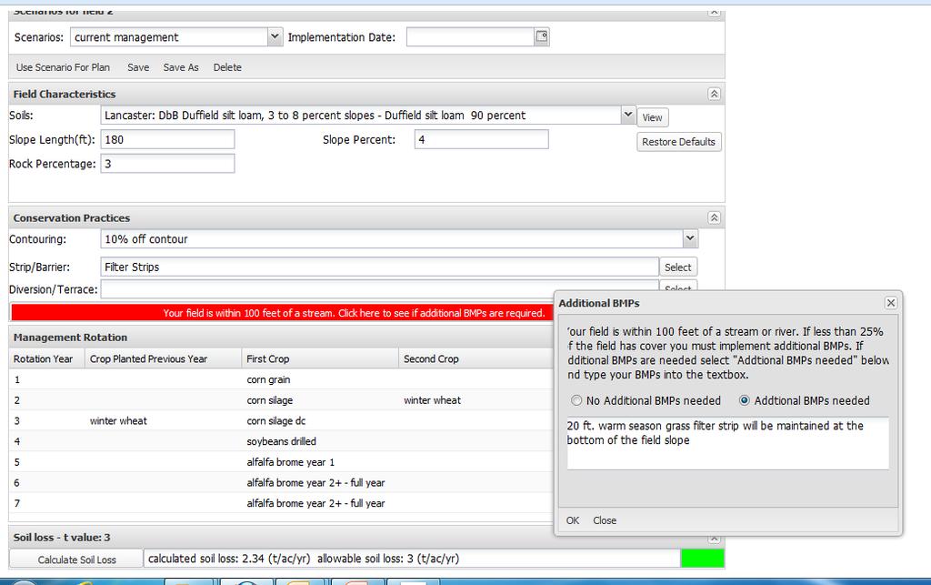
18 written E&S Plans for all agricultural plowing and tilling activities greater than 5,000 square feet that must: limit soil loss from accelerated erosion to the soil loss tolerance (T) over the planned crop rotation contain additional BMPs for fields within 100 feet of river or perennial or intermittent stream and less than 25% plant or residue cover contain plan maps that show the location of features including surface waters of this Commonwealth, and drainage patterns, field and property boundaries, buildings and farm structures, animal heavy use areas, roads and crossroads, and BMPs; soils maps; and a description of BMPs including animal heavy use area practices and procedures, tillage systems, schedules, and crop rotations contain an implementation schedule be available for review and inspection at the agricultural operation
19 Map fields using existing PaOneStop tools Determine soil loss for each field using RUSLE2 model linked to PaOneStop A=R x K x LS x C x P Extract soil, topography, climatic conditions from online databases Collect crop management information from user (crops, rotations, tillage, BMPs (contouring, terraces, strips, etc) Compare soil loss to NRCS tolerable soil loss values (T) Modify crop management and/or implement conservation practices necessary to achieve tolerable soil loss for each field. Store farm information online for future modification or access Print reports and maps summarizing the Conservation Plan Submit Conservation Plan to regulatory agencies for review

20 Soil loss estimates consistent with USDA-NRCS Multiple management scenarios Conservation practices Web operation possible
21 County -climate Field soil Rock content Slope/length Crop Management crops Tillage methods Single crop and rotations crop yield manure applications planting date BMPs: Contouring Buffers/ Strips/Barriers Diversions/terraces/basins/ditches

22

23 Representative soil Slope steepness Slope length Rock percentage T-value


")
24 Field Boundary Lidar Elevations Lidar Slopes Default slope based on statistical distribution of slope within field (75 th percentile) User may override default
25 Slope length is one of the least sensitive input parameters to RUSLE2 and one of the most difficult to determine.even in the field. Initially slope length will be based on a simple relationship with slope that has been developed and used by USDA-NRCS slope length 3% 200 ft. 8% 130 ft. 15% 70 ft. Slope length most important to soil loss on steep slopes Later versions will add optional methods to determine slope length developed relationship from existing Conservation Plans GIS / terrain analysis methods User may override default
26 Multi-year rotations Copy rotations from one field to another Edit as needed

27 Yearly Options 2 main crops Cover crops Tillage method Planting date Yield Manure app.


28 Contouring Strip cropping Buffer Strips Filter Strips Diversions Terraces

29 Start with current management Calculate soil loss If acceptable Use for Ag E&S plan If not acceptable create new scenario by modifying management practices until acceptable Can save many scenarios but only have one for Ag E&S plan Results
30
31

32 Printed plan on demand, including: Plan Summary Checklist Field by field management information Soil loss calculations T-values Implementation schedule per field mapping Data stored online for future retrieval

33 Real User Data - Example

34 users 3,189 farms 9,396 fields 64,880 features 37,767
35 AgE&S Statewide Deployment April 2014 Training Completed (5.0 CECs) hands-on DEP SW Region Pittsburgh, PA - Aug 20 (20 students) DEP NE Region Wilkes-Barre, PA - Aug 28 (16 students) SCC NMEP Stormwater/Soil Loss Workshop Oct 8 (11 students) NMEP Training Completed (5.0 CECs) hands-on Oct 30, 2014 Mercer Nov 6, 2014 Gettysburg Nov 14, 2014 Lewisburg Dec 4, 2014 Lancaster Upcoming Training Dec 28 State College (5.0 CEC) 4 6 more regional hands-on trainings through 6/30/2014 (not scheduled )

36
37 Crops Conferences Penn State Extension Lancaster Crops Conference - 1/15/2015 SEPA Crops Conference - 1/21/2015 Central PA Crops Conference - 1/30/2015 NEPA Crops Conference - 2/10/2015 Crops Field Days Penn State 16 events Blair, Lebanon, Franklin, York, Perry, Potter, Clearfield, Somerset, Butler, Mercer, Tioga, Schylkill, Elk Jan March 2014 Miscellaneous Events conferences, meetings, newsletters, press releases, fact sheets,.
38 Advisory Team state/federal agencies, industry, Extension System Functionality Copy farm tool Transfer farm to another user tool Better Imagery - Google, Bing, NRCS Better topography - USGS Row grade calculator LiDAR calculated Variable buffer sizes on different sides of line Document changes made to default field properties Field divide tool AHUA mapping enhancements Pasture erosion NWI wetlands, HQ/EV streams layers Rotation Builder more crops, managements, operations (ex. Vertical tillage) Software and database security enhancements Annual soil loss for nutrient management New RUSLE2 version Update NRCS SSURGO soil databases Assess impact of Chapter 102 on farming practices User Evaluations surveys, data analysis, field data collection Manure Management Module prototype developed but no funding to complete
39 Thank You Rick Day
BMP Verification: What is it and How Will it Impact Pennsylvania?
 BMP Verification: What is it and How Will it Impact Pennsylvania? Chesapeake Bay Program Conservation District and Agency Staff Meeting March 13, 2017 + over 400 other unique practices approved by the
Agriculture Action Packet DRAFT Attachment # FARM MAP EXAMPLE DRAFT
 Attachment # FARM MAP EXAMPLE Attachment # Conservation Systems to Meet the PA E&S Guidelines to be Used as an Interim Guideline when a Plan Meeting Soil Loss (T) Cannot be Obtained Guiding Principles
Attachment # 1. Commonwealth of Pennsylvania. Pennsylvania Code. Title 25. Environmental Protection. Department of Environmental Protection
 Attachment # 1 Commonwealth of Pennsylvania Pennsylvania Code Title 25. Environmental Protection Department of Environmental Protection Chapter 102.4 1 Attachment #1 Pennsylvania Code, 102.4 Erosion and
PENNSYLVANIA PHOSPHORUS INDEX UPDATE
 PENNSYLVANIA PHOSPHORUS INDEX UPDATE Jennifer Weld Department of Ecosystem Science and Management, Penn State University 2017 Pennsylvania Inter-Agency Nutrient Management Annual Conference November 2,
AGRICULTURAL PLANNING REIMBURSEMENT PROGRAM PENNSYLVANIA S CHESAPEAKE BAY WATERSHED
 3020-FM-CBO0003 10/2017 Cover Sheet How the Program Benefits Farmers: PENNSYLVANIA S CHESAPEAKE BAY WATERSHED Agricultural operators/landowners are reimbursed for fees they ve paid to consultants to create
Erosion and Sediment Pollution Control Guidelines for Residential Lots with soil disturbance of less than 1 acre (see exceptions)
") Adams Co. Conservation District 670 Old Harrisburg Road, Suite 201 Gettysburg, PA 17325 Telephone: 334-0636 Fax: 337-0730 www.adamscounty.us Erosion and Sediment Pollution Control Guidelines for Residential
Adams Co. Conservation District 670 Old Harrisburg Road, Suite 201 Gettysburg, PA 17325 Telephone: 334-0636 Fax: 337-0730 www.adamscounty.us Erosion and Sediment Pollution Control Guidelines for Residential
SOIL P-INDEXES: MINIMIZING PHOSPHORUS LOSS. D. Beegle, J. Weld, P. Kleinman, A. Collick, T. Veith, Penn State & USDA-ARS
 SOIL P-INDEXES: MINIMIZING PHOSPHORUS LOSS D Beegle, J Weld, P Kleinman, A Collick, T Veith, Penn State & USDA-ARS Part of a larger national effort to improve the P Index and P Management Chesapeake Bay
Pennsylvania s Phase III Watershed Implementation Plan
 Pennsylvania s Phase III Watershed Implementation Plan Informational Meeting Pennsylvania House and Senate Agriculture and Rural Affairs Committees August 16, 2017 Agenda Why Are We Doing This? Progress
A Landowner s Guide to C o n s e rvation Buffer Incentive Pro g r a m s in Pennsylvania
 A Landowner s Guide to C o n s e rvation Buffer Incentive Pro g r a m s in Pennsylvania Purpose of This Guide This guide is a compilation of the major federal, state and private voluntary conservation
Estimating Field-Scale Runoff and Sediment Delivery. Seth M. Dabney, USDA-ARS Dalmo A. N. Vieira, USDA-ARS Daniel C. Yoder, Univ.
 Estimating Field-Scale Runoff and Sediment Delivery Seth M. Dabney, USDA-ARS Dalmo A. N. Vieira, USDA-ARS Daniel C. Yoder, Univ. of Tennessee Organization Buffers for concentrated flow control Distributed
Action Packet for Agriculture
 Pennsylvania Water Quality Action Packet for Agriculture A Self Assessment and Planning Tool for Water Quality Protection Under the PA Clean Streams Law Funded by Pennsylvania Department of Environmental
Statewide Ranking of Ecological Value of CRP and other Critical Lands
 Statewide Ranking of Ecological Value of CRP and other Critical Lands Funded by ENRTF as recommended by LCCMR 2008 2009 D. J. Mulla, S. J. Taff, G. Host, J. Galzki, T. Brown, A. Lewandowski, and J. Nelson
Planting and Harvesting Crops
 Planting and Harvesting Crops Chesapeake Bay Program Agricultural Workgroup s Building a Better Bay Model Workshop 05/22/2013 Gary Shenk Chesapeake Bay Program s Integrated Analysis Coordinator Photos
Manure Management Manual Revisions
 Manure Management Manual Revisions Jim Spontak PA DEP Farms In PA 63,136 farms in PA 33813 have livestock Average farm is 124 acres, about 75% under 200 acres Women as the primary farm operator increased
Watershed BMPs. Notes from NRCS online site on BMPs. Focus on key BMPs
 Notes from NRCS online site on BMPs http://www.nrcs.usda.gov/technical/standards/nhcp.html Focus on key BMPs Function, benefits, and drawbacks listed Definition Novotny & Olem: BMPs are methods and practices
Nutrient Management Planning in Georgia:
 Nutrient Management Planning in Georgia: An overview of regulations, education, tools, and research needs. Mark Risse and David Kissel UGA Cooperative Extension Service Soil Testing Conducted by UGA AES
Agricultural/Rural Riparian Buffer Analysis
 Agricultural/Rural Riparian Buffer Analysis December 2014 Executive Summary The Agricultural/Rural Riparian Buffer Analysis was developed from a 2014 analysis of current requirements for the riparian areas
HOW CHANGES IN NUTRIENT MANAGEMENT REGULATIONS WILL AFFECT FORAGE PRODUCTION
 HOW CHANGES IN NUTRIENT MANAGEMENT REGULATIONS WILL AFFECT FORAGE PRODUCTION Dick Wolkowski and Larry Bundy Department of Soil Science University of Wisconsin What are the issues Forage producers typically
2010 Growing Season - Barton County, Kansas Land Cover Summary
 2010 Growing Season - Barton County, Kansas Land Cover Summary Number of Fields Percent of Total Fields Total Acres Percent of Acres ALFALFA 39 7.1% 3,075.5 6.4% CORN 45 8.1% 5,328.6 11.1% CRP 4 0.7% 408.5
Revised Universal Soil Loss Equation
 Revised Universal Soil Loss Equation April 2003 Sustainable Agriculture Resource Section AGDEX # 572/751 In April 2002, the Agricultural Crop Rotation Act (ACRA) was adopted to protect water and soil quality
Missouri Concentrated Animal Feeding Operation Nutrient Management Technical Standard
 Missouri Concentrated Animal Feeding Operation Nutrient Management Technical Standard March 4, 2009 Division of Environmental Quality Water Protection Program I Introduction A. Authority and Purpose Missouri
Phosphorus Update. Addy Elliott Colorado State University Department of Soil and Crop Sciences
 Phosphorus Update Addy Elliott Colorado State University Department of Soil and Crop Sciences Phosphorus Application Considerations In order to provide sufficient nutrients to crops while preserving water
Reporting of USDA Conservation Practices for Chesapeake Bay
 Reporting of USDA Conservation Practices for Chesapeake Bay Olivia H. Devereux, DEC, Inc. December 6, 2012 BMP Verification Review Panel with Dean Hively, USGS EGSC USGS Project Objectives To assist the
The Impact of Phosphorus Limiting Regulations on Land Application. A Contractor s Perspective
 The Impact of Phosphorus Limiting Regulations on Land Application A Contractor s Perspective Regulations Ohio Administrative Code, Section 3745-40 Sewage Sludge Regulations New rules governing agronomic
Iowa Nutrient Reduction Strategy: Background Information
 Iowa Nutrient Reduction Strategy: Background Information 2013 Iowa Water Conference Reid Christianson, P.E., Ph.D. Center for Watershed Protection Ellicott City, Maryland Project Components Project Goal
PENNSYLVANIA DEPARTMENT OF ENVIRONMENTAL PROTECTION VERIFICATION PROGRAM
 PENNSYLVANIA DEPARTMENT OF ENVIRONMENTAL PROTECTION QAPP Addendum VERIFICATION PROGRAM March 4, 2016 Page 1 I. Contents Tables... 4 Figures... 5 II. Introduction... 6 III. Selection of Priority BMPs for
Research and Conservation Opportunities Arising from a High Resolution LiDAR Mission for the Long Point Biosphere Reserve and Surrounding Region
 Research and Conservation Opportunities Arising from a High Resolution LiDAR Mission for the Long Point Biosphere Reserve and Surrounding Region Dr. Stewart J. Sweeney, Environmental Management Branch,
Compliance and Scoping Scenarios by Sector. Matthew Johnston University of Maryland CBPO And PA Phase III WIP Workgroup Co-Chairs 3/16/2018
 Compliance and Scoping Scenarios by Sector Matthew Johnston University of Maryland CBPO And PA Phase III WIP Workgroup Co-Chairs 3/16/2018 Developing Local Goals (Numbers Hypothetical) Step 1: Receive
Antonio Mallarino Professor, Department of Agronomy. Introduction
 2003 Integrated Crop Management Conference - Iowa State University 121 USING THE IOWA PHOSPHORUS INDEX FOR AGRONOMIC AND ENVIRONMENTAL MANAGEMENT OF FERTILIZER AND MANURE PHOSPHORUS Antonio Mallarino Professor,
Conservation Practices. Conservation Choices. These five icons will show the benefits each practice offers... 6/4/2014
 Conservation Choices Your guide to conservation and environmental farming practices. Conservation Choices These five icons will show the benefits each practice offers... The practice reduces soil erosion
On-Field Ohio! Evaluate/Revise the Ohio P Risk Index using Field Scale Edge-of-Field Monitoring Data
 On-Field Ohio! Evaluate/Revise the Ohio P Risk Index using Field Scale Edge-of-Field Monitoring Data OSU: Libby Dayton, Chris Holloman, Shane Whitacre, Sakthi Subburayalu, Greg LaBarge, USDA-ARS: Kevin
Conventional Tillage 0-15% Residue Reduced Tillage 15-30% Residue Mulch Tillage >30 % Residue Ridge Tillage >30 % Residue
 Recommendations for the Conservation Tillage Phase 6.0 Expert Panel Prepared for the Chesapeake Bay Program Partnership s Agriculture Workgroup by the Conservation Tillage Phase 6.0 Expert Panel Establishment
TECHNICAL CONTENT PROPOSED STEEP SLOPE REGULATION
 1 TECHNICAL CONTENT PROPOSED STEEP SLOPE REGULATION Draft 2/08/10 (Revised 02-14-11,Revised 02-21-11, Revised 03-03-11, Revised 04-19-11, Revised 04-20-11, Revised 05-05-11, Revised 05-09-11). DEFINITIONS
Conservation District Business Plan Steuben County Soil and Water Conservation District
 Conservation District Business Plan Steuben County Soil and Water Conservation District I find the great thing in this world is not so much where we stand as in what direction we are moving Oliver Wendell
NRCS s Soil Health Initiative and its Relationship to Water Quality
 NRCS s Soil Health Initiative and its Relationship to Water Quality Kip Potter, NRCS, Vermont United States Department of Agriculture is an equal opportunity provider and employer. The NRCS Soil Health
NUTRIENT MANAGEMENT (ac.) CODE 590
 CODE 590") IG-590-1 NATURAL RESOURCES CONSERVATION SERVICE CONSERVATION PRACTICE INSTALLATION GUIDELINES NUTRIENT MANAGEMENT (ac.) CODE 590 GUIDELINES APPLICABLE FOR ALL PURPOSES Nutrient management activities shall
IG-590-1 NATURAL RESOURCES CONSERVATION SERVICE CONSERVATION PRACTICE INSTALLATION GUIDELINES NUTRIENT MANAGEMENT (ac.) CODE 590 GUIDELINES APPLICABLE FOR ALL PURPOSES Nutrient management activities shall
Example Waste Utilization / Nutrient Management Plan. Revised 7/05
 Example Waste Utilization / Nutrient Management Plan Revised 7/05 Step 1 - Locate Operation Locate on Topo Map first. Note if any named streams or water bodies present within 2000 feet of the application
Land Application and Nutrient Management
 MODULE D Land Application and Nutrient Management Figure 34-13. Relationship between the concentration of dissolved P in subsurface drainage from 30 cm deep lysimeters and the Mehlich-3 extractable soil
Water Resources Element Appendix
 Appendix Housing Unit Projection Methodology The following assumptions were used to develop the housing unit projections for each Water Resources Element. All projections described in the and this Appendix
2010 Growing Season - Harvey County, Kansas Land Cover Summary
 2010 Growing Season - Harvey County, Kansas Land Cover Summary Number of Fields Percent of Total Fields Total Acres Percent of Acres ALFALFA 12 2.6% 683.4 2.0% CORN 77 16.5% 6,627.5 19.7% CRP 1 0.2% 13.9
Measuring and Managing Changes in Soil Health
 Measuring and Managing Changes in Soil Health PA DEP s Ag Advisory Board April 15 th, 2015 DEP South-Central Regional Office, Susquehanna Room A, Harrisburg, PA Dan Dostie USDA NRCS Presentation Topics
Reducing Farm Field Runoff Application: A Systematic Tool for Analyzing Resources
 Reducing Farm Field Runoff Application: A Systematic Tool for Analyzing Resources David Healy and Michael Winchell 2016 Esri User Conference: Mapping the Future of Agriculture Session June 29, 2016 1 Overview
Makin and Usin Management Zones A Case Study
 Makin and Usin Management Zones A Case Study Dan Breckon : Woodrill Farms, Precison Ag Specialist Doug Aspinall: Woodrill Farms, Precision Soil Scientist Management Zones Zones are a function of soils,
Erosion and Sediment Control Plan for a Timber Harvesting Operation
 3930-FM-WM0155 Rev. 7/2004 Erosion and Sediment Control Plan for a Timber Harvesting Operation 1. GENERAL INFORMATION A. Location Municipality B. Timber sale area = acres Date County C. Landowner Name
Water Plans. Water Plans: Houston County LWMP amended 2012 Winona County LWMP
 Mississippi River La Crescent Watershed: Water Plans The Mississippi River La Crescent Watershed encompasses Houston and Winona Counties. Each county has developed a 10-year rotating comprehensive local
%XLOGLQJ D &RPPXQLW\ &OHDQ :DWHU 7RROER[ 3$ :DWHUVKHG,PSOHPHQWDWLRQ 3ODQ :,3 /RFDO 3ODQQLQJ 3URFHVV 6WDNHKROGHU 0HHWLQJ
 %XLOGLQJ D &RPPXQLW\ &OHDQ :DWHU 7RROER[ 3$ :DWHUVKHG,PSOHPHQWDWLRQ 3ODQ :,3 /RFDO 3ODQQLQJ 3URFHVV 6WDNHKROGHU 0HHWLQJ A Community Clean Water Toolbox Pennsylvania Watershed Implementation Plan (WIP)
Nutrient Management in. A presentation to the West Metro Water Alliance
 Nutrient Management in Developing and Agricultural Areas A presentation to the West Metro Water Alliance Chris Meehan, P.E. May 25, 2011 Agenda Physical Improvements Planning Improvements How to get it
Door County SWCD 2016 Nutrient Management Plan Review For Haberli Farms Inc. Registered Agent Office Joseph C Haberli 6945 Memorial Dr.
 Door County SWCD 2016 Nutrient Management Plan Review For Haberli Farms Inc. Registered Agent Office Joseph C Haberli 6945 Memorial Dr. Egg Harbor, WI 54209 Nutrient Management Plan written by: Nathen
SOIL QUALITY AND CROP PRODUCTION. Dick Wolkowski Department of Soil Science University of Wisconsin
 SOIL QUALITY AND CROP PRODUCTION Dick Wolkowski Department of Soil Science University of Wisconsin WHAT IS SOIL QUALITY DEPENDS ON WHO YOU ARE: Farmer: Highly productive, sustainable media for growing
Chapter 7.2. AFFIRM and Alberta MMP Software. learning objectives
 AFFIRM and Alberta MMP Software learning objectives Identify information required to use the Alberta Farm Fertilizer Information and Recommendation Manager (AFFIRM). Identify information required to use
Characteristics of Land Resources
 Chapter Chapter 1 Characteristics of Land Resources The geology, soils and topography of Woodford County T he geology, soils and topography of an area are important to the community planning process for
Development of a tool to estimate Best Management Practices (BMP) efficiency using SWAT
 efficiency using SWAT") 5 th International SWAT Conference Development of a tool to estimate Best Management Practices (BMP) efficiency using SWAT Maringanti C., I. Chaubey, B. Engel Purdue University, West Lafayette, IN M. Arabi
5 th International SWAT Conference Development of a tool to estimate Best Management Practices (BMP) efficiency using SWAT Maringanti C., I. Chaubey, B. Engel Purdue University, West Lafayette, IN M. Arabi
New Practices for Nutrient Reduction: STRIPs and Saturated Buffers. Matthew Helmers and Tom Isenhart Iowa State University
 New Practices for Nutrient Reduction: STRIPs and Saturated Buffers Matthew Helmers and Tom Isenhart Iowa State University Situation Increasing concern for local and regional waters Substantial demand for
Aggregating and Reporting NRCS and FSA Conservation Program Data for the Chesapeake Bay Watershed
 Aggregating and Reporting NRCS and FSA Conservation Program Data for the Chesapeake Bay Watershed Dean Hively, Peter Claggett U.S. Geological Survey Eastern Geographic Science Center U.S. Department of
Phosphorus for the Ontario CCA 4R Nutrient Management Specialty
 Ontario CCA 4R Nutrient Management Workshop Wednesday, 18 January 2017 Woodstock, Ontario, Canada Phosphorus for the Ontario CCA 4R Nutrient Management Specialty Tom Bruulsema, Phosphorus Program Director
2013 Purdue Soybean On-Farm Trial ROW WIDTHS
 2013 Purdue Soybean On-Farm Trial ROW WIDTHS Shaun Casteel, Extension Soybean Specialist, Purdue Agronomy scasteel@purdue.edu, 765.494.0895 OVERVIEW This protocol describes the design and conduct of on-farm,
2016 Adams County LWCD Plan of Operations
 2016 Adams County LWCD Plan of Operations I. County Owned Dams a. Goal: Inspect, Operate and Maintain dams as specified in the I.O.M. Plan to meet State laws/standards. Action: Update I.O.M. Plan and Emergency
IS FALL TILLAGE FOLLOWING SOYBEAN HARVEST NECESSARY? 1/
 IS FALL TILLAGE FOLLOWING SOYBEAN HARVEST NECESSARY? / Introduction As growers look for opportunities to enhance profit margins, the need for fall tillage following soybean harvest is questioned. Although
Saturated Buffer. Subsurface Drainage PURPOSE N REDUCTION LOCATION COST BARRIERS
 Saturated Buffer To intercept tile drainage prior to discharging to surface waters and redistribute the water laterally in the soil profile of the streamside buffer. Subsurface drainage, also known as
Natural Resources & Environmental Stewardship
 Natural Resources & Environmental Stewardship Fundamentals of Nutrient Management Melissa L. Wilson Department of Environmental Science & Technology Ag Nutrient Management Program University of Maryland,
Nutrient Management in Kentucky
 IP-71 Nutrient Management in Kentucky Nutrient Management Focus Group, Environmental and Natural Resource Issues Task Force AGRICULTURE & NATURAL RESOURCES FAMILY & CONSUMER SCIENCES 4-H/YOUTH DEVELOPMENT
Grant All-Detail Report Projects and Practices 2015
 Grant All-Detail Report Projects and Practices 2015 Grant Title - TMDL Implementation Project Grant ID - C15-8106 Organization - Benton SWCD Grant Awarded Amount $227,500.00 Grant Execution Date 4/7/2015
Technical Training and Certification Program Individual Development Plans for technical employees
 Technical Training and Certification Program Individual Development Plans for technical employees Purpose: The goal of the Technical Training and Certification Program (TTCP) is developing and maintaining
AEN-103 Stormwater BMPs for Confined Livestock Facilities Steve Higgins and Sarah Wightman, Biosystems and Agricultural Engineering
 COOPERATIVE EXTENSION SERVICE UNIVERSITY OF KENTUCKY COLLEGE OF AGRICULTURE, LEXINGTON, KY, 40546 AEN-103 Stormwater BMPs for Confined Livestock Facilities Steve Higgins and Sarah Wightman, Biosystems
An Environmental Accounting System to Track Nonpoint Source Phosphorus Pollution in the Lake Champlain Basin. Year 2 Project Work Plan
 An Environmental Accounting System to Track Nonpoint Source Phosphorus Pollution in the Lake Champlain Basin Mary Watzin and Lula Ghebremichael University of Vermont, Rubenstein School of Environment and
Mississippi River Basin Healthy Watershed Initiative
 Mississippi River Basin Healthy Watershed Initiative A Progress Report for Arkansas Presented by: Mike Sullivan, State Conservationist FY 2010 12 States 41 Focus Areas FY 2011 Added two focus areas: SD/MS
Center for Nutrient Solutions (CNS): An Innovative Approach to Exploring Nutrient Pollution Solution Scenarios
: An Innovative Approach to Exploring Nutrient Pollution Solution Scenarios") Center for Nutrient Solutions (CNS): An Innovative Approach to Exploring Nutrient Pollution Solution Scenarios One of 4 centers funded by EPA-STAR Program for Innovative and Sustainable Water Research
Center for Nutrient Solutions (CNS): An Innovative Approach to Exploring Nutrient Pollution Solution Scenarios One of 4 centers funded by EPA-STAR Program for Innovative and Sustainable Water Research
Act 38 Nutrient Balance Sheet Standard Format Word Version User Guide & Sample Nutrient Balance Sheet October 2017
 Act 38 Nutrient Balance Sheet Standard Format Word Version User Guide & Sample Nutrient Balance Sheet Pennsylvania Nutrient Management Program Pennsylvania's Nutrient Management Act (Act 38, 2005) Introduction
THE FUTURE OF NUTRIENT MANAGEMENT IN WISCONSIN
 THE FUTURE OF NUTRIENT MANAGEMENT IN WISCONSIN Susan M. Porter 1 The Department of Agriculture, Trade and Consumer Protection (DATCP) is responsible for promulgating nutrient management rules in Wisconsin
Assessing Regional Water Impacts of Biofuel Production Scenarios
 Assessing Regional Water Impacts of Biofuel Production Scenarios May Wu, Yonas Demissie, Eugene Yan Argonne National Laboratory GWPC Annual Forum Water and Energy Sustainability Sept. 26-29, 2010 Pittsburgh,
Small-Scale Farmers and the Environment: How to be a Good Steward
 L P E S Small Farms Fact Sheet series Livestock and Poultry Environmental Stewardship < L P E S > Curriculum : How to be a Good Steward By Mark Rice, North Carolina State University Summary Good stewardship
Implementation of Priority CRP Conservation Practices and Estimated Nutrient Load Reductions
 1 Minnesota Nutrient Reduction Strategy Agricultural Sector/FSA CRP Program Measures Implementation of Priority CRP Conservation Practices and Estimated Nutrient Load Reductions Measure Background Visual
What Works: Farming Practices
 What Works: Farming Practices Forestry, Farming and Filtration: Productive Lands and Water Supplies Can Coexist September 23, 2010 St. Paul Center, Augusta, Maine Farming Practices Protect Water Nutrient
7.10 BRA Sediment Reduction Program
 7.10 BRA Sediment Reduction Program 7.10.1 Description of Option The protection of already developed water supplies is a key element of water supply planning. Because Region G s inventory of suitable sites
Guide for Using RUSLE2 in Organic Systems
 Guide for Using RUSLE2 in Organic Systems August 2016 NRCS www.nrcs.usda.gov Oregon Tilth www.tilth.org Acknowledgements Authors Ben Bowell (Oregon Tilth) and and Giulio Ferruzzi (NRCS) Reviewers and contributors
12/28/2016. Air. Surface Water. Ground Water. Soil. 1. Calculate agronomic rate. 2. Identify optimal fields. 3. Determine when to apply
 Air Ground Surface Nichole Embertson, Ph.D. Management Specialist Whatcom Conservation District Far West Agribusiness Kennewick, WA December 13, 2016 Soil Manure Agronomics & Balance Soil s in grain, forage
Agricultural NPS Measures. Kevin Wagner Aaron Wendt
 Agricultural NPS Measures Kevin Wagner Aaron Wendt How are Ag BMPs Implemented? Texas Conservation Partnership Providing Conservation Assistance to Private Landowners for 70 Years LOCAL- 217 Soil and Water
Central Coast Water Board Agricultural Order R Angela Schroeter Agricultural Regulatory Program
 Central Coast Water Board Agricultural Order R3-2012-0011 Angela Schroeter Agricultural Regulatory Program Background Photo: Morro Bay, CA Overview Role of the Water Board Agricultural Order R3-2012-0011
State College March 6, 2017
 State College March 6, 2017 Paul Racette Pennsylvania Environmental Council Mike Hickman Center for Watershed Protection Alice R. Baker PennFuture 1 Pennsylvania Environmental Council Photos: Rutgers Cooperative
Phosphorus for the Ontario CCA 4R Nutrient Management Specialty
 Ontario CCA 4R Nutrient Management Workshop Thursday, July 21, 2016 Holiday Inn, Guelph Phosphorus for the Ontario CCA 4R Nutrient Management Specialty Tom Bruulsema, Phosphorus Program Director Lake Erie
Current Nutrient Management Strategies for Poultry Production. Josh B. Payne, Ph.D. Animal Waste Mgmt. Specialist
 Current Nutrient Management Strategies for Poultry Production Josh B. Payne, Ph.D. Animal Waste Mgmt. Specialist Animal Production Trend Transitioned to achieve an economy of scale Low profit margins &
LPES Small Farms Fact Sheets* Small-Scale Farmers and the Environment: How to be a Good Steward. By Mark Rice, North Carolina State University
 LPES Small Farms Fact Sheets* Small-Scale Farmers and the Environment: How to be a Good Steward By Mark Rice, North Carolina State University Summary Good stewardship is important for everyone, including
WORKING PAPER How Baywide Nutrient Trading Could Benefit Pennsylvania Farms
 WORKING PAPER How Baywide Nutrient Trading Could Benefit Pennsylvania Farms JOHN TALBERTH, CY JONES, MICHELLE PEREZ, MINDY SELMAN, EVAN BRANOSKY World Resources Institute Working Papers contain preliminary
Tioga County Conservation District Watershed Program
 Tioga County Conservation District Watershed Program What is a watershed? A watershed is the land area that drains into a stream, river, or body of water. In Tioga County, there are seven major watersheds,
DEPARTMENT OF ENVIRONMENTAL PROTECTION Bureau of Oil and Gas Management
 DOCUMENT NUMBER: ***-****-*** EFFECTIVE DATE: Month DD, YYYY DEPARTMENT OF ENVIRONMENTAL PROTECTION Bureau of Oil and Gas Management TITLE: Addressing Spills and Releases from Oil & Gas Wells and Related
Closing Pennsylvania s Pollution-Reduction Gap
 Closing Pennsylvania s Pollution-Reduction Gap Investing for Performance: The 3 Ps The Chesapeake Bay and its rivers and streams are a national treasure draining parts or all of six states and the District
Ch. 102 EROSION AND SEDIMENT CONTROL 25 CHAPTER 102. EROSION AND SEDIMENT CONTROL GENERAL PROVISIONS
 Ch. 102 EROSION AND SEDIMENT CONTROL 25 CHAPTER 102. EROSION AND SEDIMENT CONTROL GENERAL PROVISIONS Sec. 102.1. Definitions. 102.2. Scope and purpose. 102.3. [Reserved]. 102.4. Erosion and sediment control
JEFFERSON COUNTY CONSERVATION DISTRICT 2013 ANNUAL REPORT
 JEFFERSON COUNTY CONSERVATION DISTRICT 2013 ANNUAL REPORT About the Conservation District 2 The county was declared a District by the Jefferson County Board of Commissioners in October, 1946, in accordance
COMPREHENSIVE NUTRIENT MANAGEMENT PLAN REVIEW CHECKLIST FOR CERTIFIED CNMP PROVIDERS
 Customer Name: CNMP Preparer s Name: CNMP Reviewer s Name and Date: COMPREHENSIVE NUTRIENT MANAGEMENT PLAN REVIEW CHECKLIST FOR CERTIFIED CNMP PROVIDERS COMPONENT Yes No NA 1. Overview - Brief statement
A Model Integration Framework for Assessing Integrated Landscape Management Strategies
 A Model Integration Framework for Assessing Integrated Landscape Management Strategies Jared M. Abodeely 1, David J. Muth 1, Joshua B. Koch 1, and Kenneth M. Bryden 2 1 Idaho National Laboratory, Idaho
Land application of manure for water quality protection : A play in three acts
 Land application of manure for water quality protection : A play in three acts Peter Kleinman USDA-ARS University Park, Pennsylvania Mark Goodson USDA-NRCS Harrisburg, Pennsylvania With a little help from
Phosphorus Loading to Western Lake Erie: Trends and Sources
 Phosphorus Loading to Western Lake Erie: Trends and Sources Western Lake Erie Conference Toledo Yacht Club March 13, 28 Dr. David B. Baker National Center for Water Quality Research Heidelberg College
Unsustainable Agriculture. Pennsylvania s Manure Hot Spots and their Impact on Local Water Quality and the Chesapeake Bay
 Unsustainable Agriculture Pennsylvania s Manure Hot Spots and their Impact on Local Water Quality and the Chesapeake Bay AUGUST 31, 2017 ACKNOWLEDGEMENTS This report was researched and written by Abel
By Richard Smardon PhD Professor of Environmental Studies, SUNY/ESF
 TREATMENT WETLAND RESEARCH & IMPLEMENTATION IN CENTRAL NEW YORK as part of Wetlands, Watersheds and Resources Technical Assistance partnership Forum Thursday March 22, 2012 Center of Excellence By Richard
CAEP Study Site: Cannonsville Reservoir Watershed
 Tammo Steenhuis, Zach Easton, Eric White, C. Shoemaker Joshua Woodbury and many others of the Soil and Water Laboratory, Farming Community and the Watershed Agriculture Program in Walton This project is
How Nutrient Trading Can Help Restore the Chesapeake Bay
 WRI FACT SHEET How Nutrient Trading Can Help Restore the Chesapeake Bay Congress is considering proposals to revise and strengthen the Clean Water Act for the Chesapeake Bay region and improve the health
Determining rangeland suitability for cattle grazing based on. distance-to-water, terrain, and barriers-to-movement attributes
 Determining rangeland suitability for cattle grazing based on distance-to-water, terrain, and barriers-to-movement attributes Dennis L. Oberlie 1 and Joseph A. Bishop 2 Authors are 1 Aquatic Habitat Supervisor,
Central Oregon Irrigation District
 Central Oregon Irrigation District On-Farm Water Conservation Report Prepared by: Black Rock Consulting 320 SW Upper Terrace Drive, Suite #102, Bend, Oregon 97702 (541) 480-6257 & Farmers Conservation
Best Management Practices (BMPs) are structural
 are structural") Agriculture and Natural Resources WATER QUALITY: Controlling Nonpoint Source (NPS) Pollution A L A B A M A A & M A N D A U B U R N U N I V E R S I T I E S ANR-790-4.2.3 The Rural Environment And NPS Pollution
Agriculture and Natural Resources WATER QUALITY: Controlling Nonpoint Source (NPS) Pollution A L A B A M A A & M A N D A U B U R N U N I V E R S I T I E S ANR-790-4.2.3 The Rural Environment And NPS Pollution