Developing a One Stop ArcIMS Application for High Accident Location (HAL) Management
|
|
|
- Griselda Johnston
- 5 years ago
- Views:
Transcription
 Management March 28, 2007 Charlie Jones Darin")
1 Developing a One Stop ArcIMS Application for High Accident Location (HAL) Management March 28, 2007 Charlie Jones Darin Herle
2 Agenda About the Charlotte DOT CDOT Traffic Safety Section Application needs Architecture and Design Application Features What makes CRAS unique? Lessons learned Summary Q & A
3 City of Charlotte Department of Transportation 400+ Employees 6 Divisions Street Maintenance Engineering & Operations Planning & Design Development Services\ Public Service & Communications Departmental Services CDOT is responsible for the planning, maintenance, and construction activities on; 2,100 miles of roadway 670 signalized intersections 1,563 miles of sidewalk 40 miles of bikeways
4 CDOT Traffic Safety Section Staff of 5 responsible for 4 major duties Compile and analyze collisions involving motor vehicles, bicycles, and pedestrians within the City of Charlotte. Average 25,000 crashes annually. Section staff performs quality control and geo codes each report. Provide collision data and analysis to City staff, citizens, and the media in the form of annual reports, location specific reports, and highly customized statistical reports. Monitor crashes at locations on an ongoing basis. Develop and implement projects annually to reduce all types of collisions within the City.
5 CDOT s Need for a GIS Solution Existing System Elements MS Access Databases Collision data Safety Project Information Safety Committee Meeting minutes Collision Diagram database Fatality Data Yearly High Accident Lists (HAL) SQL Database Collision data File Servers All other data in various formats MS Excel, AutoCAD, ArcMap Paper Storage Something was needed to tie it all together!


6 Software Architecture & Design Web browser based! ArcIMS 9.0 ArcSDE 9.0 Geocortex IMF 5.0 SQL Server 2003 SQL Server Reporting Services Design goal: COTS components
 Telephone Help Desk CDOT ` AutoCAD desktop Accident Locating System Data Extraction App Other desktop apps")
7 Hardware Architecture CRAS Target Concept Technical Architecture CMPD Web Servers CRAS DBMS File Servers Crash Report files Application Servers Data Servers AutoCAD CMPD Data Feed CoC High speed Ethernet Backbone ` Other Services Network Domain services, et al Exchange servers ( ) Telephone Help Desk CDOT ` AutoCAD desktop Accident Locating System Data Extraction App Other desktop apps (e.g., MS Excel) `
8 GIS Mapping/IS integration Application Features

9 IT Application GIS Application
10 GIS Mapping/IS integration User profiles/security Application Features

11
12 GIS Mapping/IS integration User profiles/security Application Features Crash Data/Active Intersections filtering and theming


13
14 GIS Mapping/IS integration User profiles/security Application Features Crash Data/Active Intersections filtering and theming Reporting

15
16
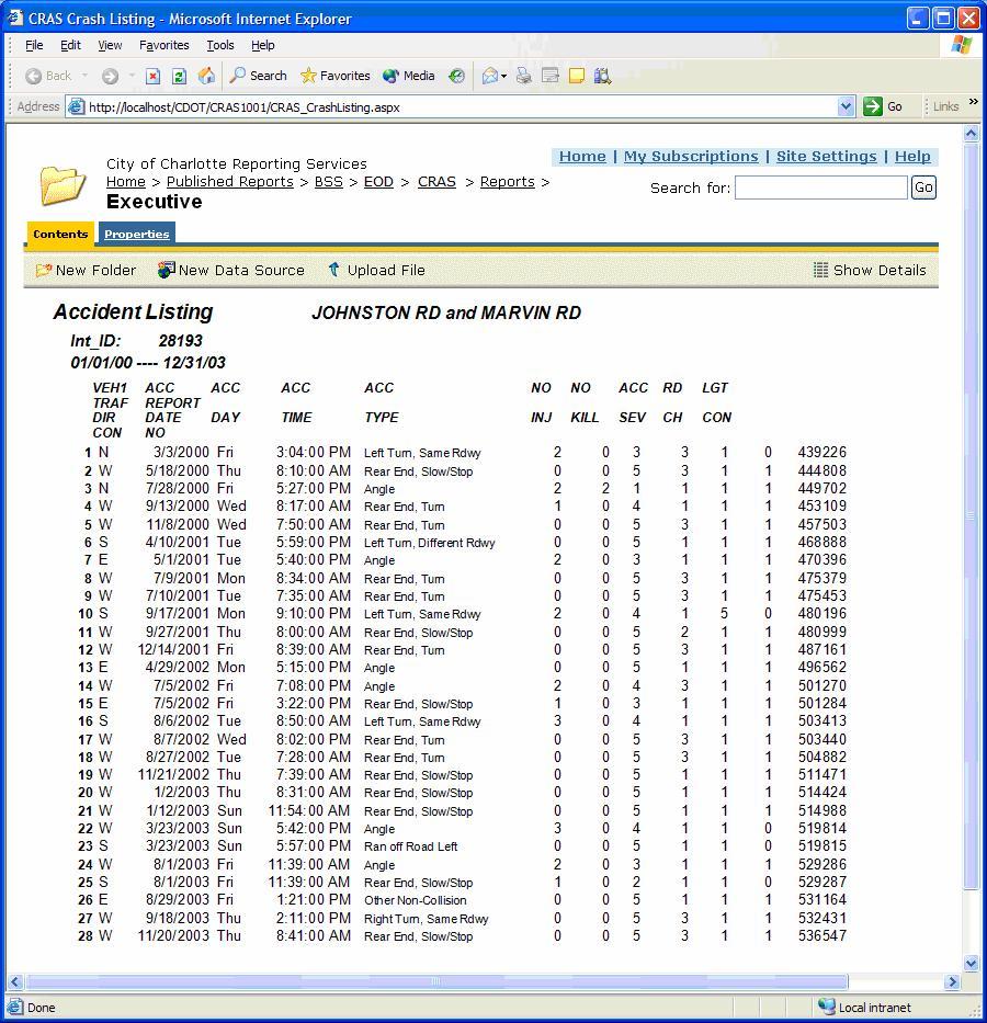
17 GIS Mapping/IS integration User profiles/security Application Features Crash Data/Active Intersections filtering and theming Reporting High Accident Listing
18 High Accident Location (HAL) Lists Calculated annually and released publicly since the early 80 s. Used as a tool to prioritize safety improvement projects. Intersections citywide are ranked based on a 3 year crash rate CRAS Application will generate HAL based on year selected R = C * 1, 000, 000 V * N * 365 C = Number of Collisions (3 Years) N = Number of Years V = Volume R expressed as Crashes per million entering vehicles
 Lists")
19 High Accident Location (HAL) Lists Sample
20 GIS Mapping/IS integration User profiles/security Application Features Crash Data/Active Intersections filtering and theming Reporting High Accident Listing Location Monitoring/Work Order Management
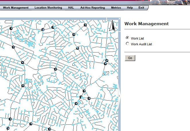


21
22 GIS Mapping/IS integration User profiles/security Application Features Crash Data/Active Intersections filtering and theming Reporting High Accident Listing Location Monitoring/Work Order Management Image Viewing

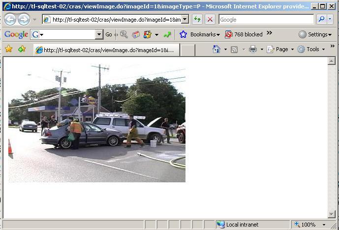
23
24 GIS Mapping/IS integration User profiles/security Application Features Crash Data/Active Intersections filtering and theming Reporting High Accident Listing Location Monitoring/Work Order Management Image Viewing Transportation Safety Committee (TSC) Management
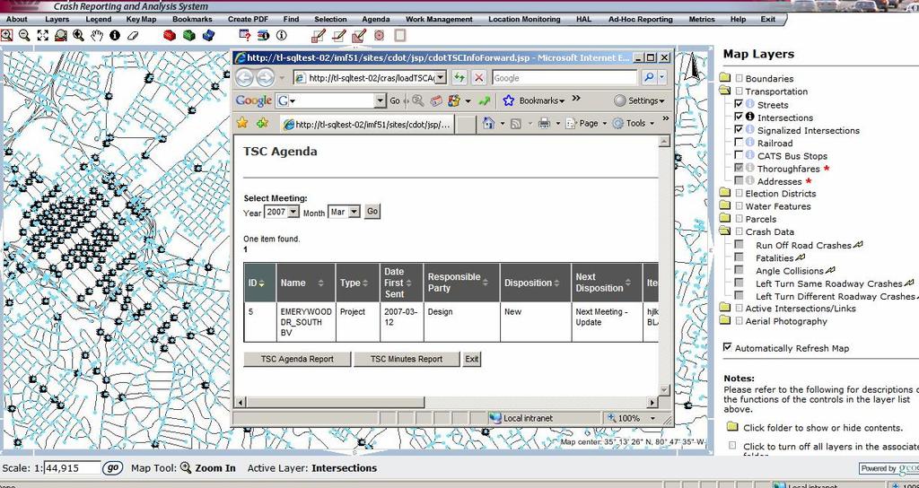
25
26 Things that make CRAS unique: Functional and User Centric Components It pulls together so many commonly used functions into a single interface User Assembles GIS and IS applications into a common interface Leverages GIS tools for specific functions: Map interface Layers Select (Buffer, rectangle, polygon) Identify Truly a One Stop application for crash data
27 Lessons Learned
28 What did we learn? Documentation and regular communication is the key to a successful client/vendor relationship. CDOT TSS hired a technical business process consultant to facilitate the project development. Consultant produced the following documentation for the project Current System Document Target Concept Document High Level Design Document Requirements Document 52 Pages! Acceptance Test Plan Weekly Status meetings
29 Summary
30 Q & A
31
Using ArcGIS Online to Support Transportation Engineering. ESRI Southeast User Conference May 2, 2016 Daniel R. Mellott, GISP Sain Associates
 Using ArcGIS Online to Support Transportation Engineering ESRI Southeast User Conference May 2, 2016 Daniel R. Mellott, GISP Sain Associates Presentation Overview Horizontal Curve History Project Obstacles
Taking Advantage of ArcGIS Online to Push a Mobile Agenda
 2013 Esri International User Conference July 8 12, 2013 San Diego, California Taking Advantage of ArcGIS Online to Push a Mobile Agenda Michael Olkin Town of Amherst, MA Esri UC2013. Some of our goals
Integration of GIS, Asset Management and Call Center Technology. Presented by: Steve Sherman City of Greensboro
 Integration of GIS, Asset Management and Call Center Technology Presented by: Steve Sherman City of Greensboro Agenda Background on Greensboro s project environment Asset Management project GIS Integration
Enterprise Technology And Solutions by ESRI. Dave Wrazien Solution Architect ESRI, Inc.
 Enterprise Technology And Solutions by ESRI Dave Wrazien Solution Architect ESRI, Inc. What is Enterprise? An enterprise consists of all functional departments, people, and systems within an organization.
Connecticut Local Road Safety Plans TECH BRIEF
 Connecticut Local Road Safety Plans TECH BRIEF 2014-2 Of the 21,000 miles of roadway in Connecticut, 82% are maintained by local municipal agencies. In 2013, 50% of roadway departure injury crashes and
6. Safety and Security
 Police at the Democratic National Convention in Uptown Charlotte. New transportation legislation, Moving Ahead for Progress in the 21st Century (MAP-21), enacted in 2012, continues the use of the same
PLANNING SNAPSHOT 7:
 PLANNING SNAPSHOT 7: CRASH DATA JANUARY 2016 Funded through the NCHRP 8-36 Research Series, these snapshots are designed to tell you a little about the current state of a specific planning practice of
Seed-Project - Transportation Safety Resource
 Safety-RU4474 Seed-Project - Transportation Safety Resource Development of an Enhanced Crash Data Analysis Tool: A Plan for Safety FINAL REPORT March 2006 Submitted by Anna Okola * Traffic Engineer Ardavan
5/19/2008 Planning & Engineering 1
 5/19/2008 Planning & Engineering 1 HISTORY In 1900 the citizens of Shakopee voted to own and operate their electric utility The ownership of the system the past 100 years has been both a wonderful financial
CITY of NOVI CITY COUNCIL
 CITY of NOVI CITY COUNCIL Agenda Item F December 5, 2011 cityofnovi.org SUBJECT: Approval to purchase Cityworks software from Azteca Systems, a sole-source provider, to support the City's asset management
Safety Performance Management Targets. Transportation Policy Board January 11, 2018
 Safety Performance Management Targets Transportation Policy Board January 11, 218 Federal Requirements - Background MAP-21/FAST Act established new emphasis on performance and outcome based planning Required
City of Fairfield GIS Management Portal Implementation
 City of Fairfield GIS Management Portal Implementation Shakeel Ajam GIS/Software Dev. Manager City of Fairfield, CA Charlie Crocker Vice President Farallon Geographics, Inc. Today s Goals Present City
Crowd Cartography: Mobile crowdsourcing of university facilities mapping
 Crowd Cartography: Mobile crowdsourcing of university facilities mapping Bob Nichols (bob.nichols@wsu.edu) Washington State University Founded 1890 Land Grant Institution Over 26,000 undergraduate, graduate,
Building West Virginia DOT s Geospatial Capabilities:
 Building West Virginia DOT s Geospatial Capabilities: GIS Web Portal And Straight-line Diagram Application Current Status, Upcoming Enhancements, and Integration Marshall Burgess, WVDOT Don Kiel, GeoDecisions
Emerging Mobility Services and Technologies
 Emerging Mobility Services and Technologies Draft Report Evaluation Results and Recommendations SAN FRANCISCO COUNTY TRANSPORTATION AUTHORITY June 11, 2018 Emerging Mobility Services and Technologies 2
Location-driven business at the
 Location-driven business at the Utah Department of Transportation Jeff Saunders Farallon Geographics, Inc. Senior Geodatabase Developer Dan Paske Utah Department of Transportation Oracle DBA Today s Goals
Adaptation of HERS-ST Models for the South Carolina Interactive Interstate Management System
 Adaptation of HERS-ST Models for the South Carolina Interactive Interstate Management System presented to the Transportation Research Board HERS Modeling and Data Integration Conference presented by William
Development of a Decision Making Process for the HSM Implementation
 2015 UTC Conference of the Southeastern Region March 26-27, 2015 Development of a Decision Making Process for the HSM Implementation Priyanka Alluri, Ph.D., P.E. Assistant Professor Department of Civil
DEVELOPMENT OF A GIS-BASED TRAFFIC SAFETY ANALYSIS SYSTEM
 0 0 0 0 DEVELOPMENT OF A GIS-BASED TRAFFIC SAFETY ANALYSIS SYSTEM Vidhya Kumaresan, M.S.E., E.I.T. Research Associate Vinod Vasudevan, M.S.E., P.E. Associate Research Engineer Transportation Research Center
One Maryland One Centerline. GIS-T 2014 May 7, 2014
 One Maryland One Centerline GIS-T 2014 May 7, 2014 Current Road Centerlines in Maryland SHA maintains a statewide centerline Supports HPMS program Represents state and local roads Capturing dual carriageways
NOMINATION FORM. Zip: Phone: 217/ Fax: 217/
 NOMINATION FORM Title of Nomination: GIS Internet Road Construction Application Project/System Manager: Dennis Jones Job Title: Management Systems Manager Agency: Illinois Department of Transpiration Department:
MAP INTERFACE FOR IOWA DEPARTMENT OF TRANSPORTATION S ACCESS-ALAS
 MAP INTERFACE FOR IOWA DEPARTMENT OF TRANSPORTATION S ACCESS-ALAS Aravind Gottemukkula Center for transportation education and research Iowa State University ABSTRACT This paper discusses the limitations
Pauline Kent Enterprise Spatial Services Portfolio Manager Information Services. Mapshare Migration The Journey
 Pauline Kent Enterprise Spatial Services Portfolio Manager Information Services Mapshare Migration The Journey Drivers 2 Drivers 12 legacy (officially Zombie status) web mapping sites 3 Drivers 12 legacy
Utilizing Transportation Data for Low Cost Safety Improvements
 Utilizing Transportation Data for Low Cost Safety Improvements Samuel Sturtz Transportation Planner Iowa Department of Transportation samuel.sturtz@dot.iowa.gov Photo Credits: Ken West- Kenneth G. West
APPENDIX A - PLANS AND POLICY REVIEW FEBRUARY 2017
 APPENDIX A - PLANS AND POLICY REVIEW FEBRUARY 2017 DENVERMOVES Transit Denver Moves: Transit APPENDIX A PLANS AND POLICY REVIEW 2035 Metro Vision Regional Transportation Plan (MVRTP) (2011) 2040 Fiscally
PERFORMANCE-BASED PLANNING AND PROGRAMMING
 February 2017 performance-based planning and programming Boston Region MPO PERFORMANCE-BASED PLANNING AND PROGRAMMING WHAT IS PERFORMANCE-BASED PLANNING AND PROGRAMMING? Performance-based planning and
SR. GEOGRAPHIC INFORMATION SYSTEMS ANALYST
 NOVEMBER 2016 FLSA: EXEMPT Bargaining Unit: JCN: SR. GEOGRAPHIC INFORMATION SYSTEMS ANALYST DEFINITION Under general direction, leads, trains, oversees, sets priorities, and directs the work of staff on
Using Workflow Modeling for Purpose Built Web GIS Solutions. Scott Stafford Veale October 25, 2011
 Using Workflow Modeling for Purpose Built Web GIS Solutions Scott Stafford Veale October 25, 2011 Let s go back in time An short historical view of Web GIS 2 Web-GIS Approach Early 2000s, Map Servers arrive..
2. Guiding Principles, Objectives, and Policies
 2. Guiding Principles, Objectives, and Policies INTRODUCTION The guiding principles for the 2040 MTP Update establish the vision and key focus areas for this planning effort. They combine the guidance
Esri Roads and Highways An Introduction. Nathan Easley Rahul Rakshit
 Esri Roads and Highways An Introduction Nathan Easley Rahul Rakshit Roads and Highways Linear Referencing for the Transportation Enterprise GIS-enabled LRS platform LRS management LRS editing & maintenance
The Complete Trip - a Transit Driven Movement towards a Seamless Total Travel Experience
 The Complete Trip - a Transit Driven Movement towards a Seamless Total Travel Experience National Rural ITS Conference September 20, 2012 Marlene Connor, Director of Public Transportation Planning for
Implementing Enterprise Asset Management Systems and the Associated Technology Challenges
 Implementing Enterprise Asset Management Systems and the Associated Technology Challenges SERUG 2012 May 1, 2012 Introduction Bill Millinor, MS, GISP Jones Edmunds wmillinor@jonesedmunds.com Brian Rosenfeld,
FY 2019 Unified Planning Work Program FINAL. Regional Intergovernmental Council. June 14, Kanawha Putnam Metropolitan Planning Organization
 FY 2019 Unified Planning Work Program FINAL Regional Intergovernmental Council Kanawha Putnam Metropolitan Planning Organization June 14, 2018 315 D Street. South Charleston, WV. 25303 The Unified Planning
Florida Department of TRANSPORTATION. FDOT Update. Florida Urban Traffic Engineering Council (FLUTEC) Florida Section ITE (FSITE) October 30, 2018
 Florida Section ITE (FSITE) October 30, 2018") Florida Department of TRANSPORTATION FDOT Update Florida Urban Traffic Engineering Council (FLUTEC) Florida Section ITE (FSITE) October 30, 2018 Agenda Traffic Services Speed Zone Manual Intersection Control
Florida Department of TRANSPORTATION FDOT Update Florida Urban Traffic Engineering Council (FLUTEC) Florida Section ITE (FSITE) October 30, 2018 Agenda Traffic Services Speed Zone Manual Intersection Control
PERFORMANCE-BASED PLANNING AND PROGRAMMING
 February 2017 performance-based planning and programming Boston Region MPO PERFORMANCE-BASED PLANNING AND PROGRAMMING WHAT IS PERFORMANCE-BASED PLANNING AND PROGRAMMING? Performance-based planning and
SafetyAnalyst. Introduction
 SafetyAnalyst Introduction The SafetyAnalyst software was developed as a cooperative effort between FHWA and participating state and local agencies and was transferred to AASHTO in 2010. SafetyAnalyst
TRANSPORTATION ENGINEERING ASSOCIATE, 7280
 CITY OF LOS ANGELES CIVIL SERVICE COMMISSION CLASS SPECIFICATION POSTED JUNE 1999 7-01-98 TRANSPORTATION ENGINEERING ASSOCIATE, 7280 Summary of Duties: Performs professional transportation engineering
INDUSTRY. Transportation
 INDUSTRY Transportation Solutions Keeping people and products moving safely and efficiently In a world of constant change, keeping people and products moving safely and efficiently is a complex, unrelenting
Acme Software, Inc. Ajax Milestone Delivery Plan. Implementation Roadmap. Revision /14/05. CxSample_ImplementationRoadmap.
 Acme Software, Inc Ajax Milestone Delivery Plan Implementation Roadmap Revision 1.0 -- 06/14/05 CxSample_ImplementationRoadmap.doc Construx Software 10900 NE 8 th Street, Suite 1350 Bellevue, WA 98004
New Analytical Tools for Safety Management of Urban and Suburban Arterials. Douglas W. Harwood Midwest Research Institute Kansas City, MO
 New Analytical Tools for Safety Management of Urban and Suburban Arterials Douglas W. Harwood Midwest Research Institute Kansas City, MO Key Developments New and better organized information on countermeasure
Keeping people and products moving safely and efficiently
 Solutions for Transportation 2 Keeping people and products moving safely and efficiently In a world of constant change, keeping people and products moving safely and efficiently is a complex, unrelenting
ESRI, GIS & the Telecommunications Enterprise: Solutions, Status and Vision. Kees van Loo Business Development Manager ESRI
 ESRI, GIS & the Telecommunications Enterprise: Solutions, Status and Vision Kees van Loo Business Development Manager ESRI Agenda Introduction Update ESRI in Telco Telecom GIS Architecture New Users: Telecom
Introduction to ArcGIS for Situational Awareness. Bruce Robinson
 Introduction to ArcGIS for Situational Awareness Bruce Robinson Overview Complete out-of-the-box Data fusion & management capability Serve data to other mapping packages 2D & 3D GIS viewers Applications
Highway Safety Manual Implementation. Priscilla Tobias, P.E. State Safety Engineer Illinois Department of Transportation
 Highway Safety Manual Implementation Priscilla Tobias, P.E. State Safety Engineer Illinois Department of Transportation HSM Lead State Peer to Peer Workshop Highlights Illinois HSM Implementation HSM Lead
2015 Business Plan. Abe Kani Department Director/CIO
 2015 Business Plan Abe Kani Department Director/CIO Agenda Current Organization and Workforce Environment Core IT Services We Currently Support County Expectations from ITS Our Vision and Mission ITS Challenges
PEDESTRIAN RAMP PROGRAM
 PEDESTRIAN RAMP PROGRAM 2019 NYC EXISTING CONDITIONS Vast and Complex Infrastructure Landscape 6,000 miles of roadway 12,000 miles of sidewalk 162,000+ corners 320,000+ pedestrian ramps Vast network of
Integration of GIS into Policing. Valdosta, Georgia
 Integration of GIS into Policing Valdosta, Georgia Valdosta, Georgia Total population: 50,000+/- Households: 18,900 Road miles: 293 South Georgia RDC South Georgia RDC One of sixteen RDCs in Georgia Serves
Lessons Learned: Development of a GIS based Landslide Hazard Management System
 Lessons Learned: Development of a GIS based Landslide Hazard Management System By Wael Zatar and Paulus Wahjudi (Marshall University) Lawrence Douglas and Hussein Elkhansa (WVDOT) Geohazards Forum August
Process to Identify High Priority Corridors for Access Management Near Large Urban Areas in Iowa
 Process to Identify High Priority Corridors for Access Management Near Large Urban Areas in Iowa David Plazak and Reg Souleyrette Center for Transportation Research and Education Iowa State University
Livability 2050 Regional Transportation Plan Update. Transportation Policy Board (TPB) August 23, 2018
 August 23, 2018") Livability 2050 Regional Transportation Plan Update Transportation Policy Board (TPB) August 23, 2018 1 Oct. 2017 Plan Kick-Off Sept. 2019 Plan Adoption Timeline Livability 2050 Regional Transportation
Livability 2050 Regional Transportation Plan Update Transportation Policy Board (TPB) August 23, 2018 1 Oct. 2017 Plan Kick-Off Sept. 2019 Plan Adoption Timeline Livability 2050 Regional Transportation
Regional Transportation and Land Use Performance Measures. July 7, 2010 Eric Stringfield Director of Transportation and Land Use
 Regional Transportation and Land Use Performance Measures July 7, 2010 Eric Stringfield Director of Transportation and Land Use Transportation and Land Use Coordination Foundation: Traffic Impact Analysis
Traffic. Community Planning and Development. Traffic Administration Traffic Engineering. Paint and Signs
 Community Planning and Development Administration 101-7710 Transportation Planning 101-7720 Engineering Paint and Signs 141-7750 Communications 101-7740 Data 141-7760 Signals 141-7770 Safety and Signals
Data processing. In this project, researchers Henry Liu of the Department of Civil Engineering and
 Data mining of transit vehicle location, passenger count, and fare collection databases for intelligent transportation applications Supporting efficient transit service by maximizing the use of available
Safety Management System
 Oregon Department of Transportation Safety Management System Safety Priority Index System (SPIS) OREGON DEPARTMENT of TRANSPORTATION Traffic Engineering and Operations Section Transportation Safety Division
The Power of Data Integration
 The Power of Data Integration Building a Quality Crash Record through Data Collaboration, Coordination and Integration Lynn Peterson Secretary Cam Gilmour Deputy Secretary Nadine Jobe Crash Data and Reporting
Technology Roadmap Status
 Guy Michaud, Director of ITS & CIO Technology Roadmap Status IT Sub-Committee June 18, 2012 Agenda Technology Roadmap Overview Status Update ( Nov 21, 2011 - Jun 1, 2012 ) Going Forward Questions 2 Purpose
HANOVER COUNTY PUBLIC SAFETY GEOGRAPHIC INFORMATION SYSTEM WEB APPLICATION JJune 2011
 HANOVER COUNTY PUBLIC SAFETY GEOGRAPHIC INFORMATION SYSTEM WEB APPLICATION JJune 2011 PUBLIC SAFETY GEOGRAPHIC INFORMATION SYSTEM WEB APPLICATION Category: Criminal Justice & Public Safety Project Summary
RTP TAC No. 1 December 10, 2015
 RTP TAC No. 1 December 10, 2015 Study Team YMPO Staff and TAC Members Kimley-Horn and Associates Lead Firm Wilson and Co. Travel Demand Modeling Gordley Group Public Involvement Study Purpose and Objectives
The City of London Microsoft Dynamics CRM and Esri GIS Integration
 The City of London Microsoft Dynamics CRM and Esri GIS Integration Presented by Dean Thompson, Manager, Application Development Hossein Eghanian, Business System Analyst Tyson Jauniaux, Business System
GIS Centric Approach to Enterprise GIS HCG Case Study
 GIS Centric Approach to Enterprise GIS HCG Case Study GIS, as a part of local government has taken deep root globally. As systems mature beyond the point of creation and maintenance, a new evolution is
MPC 6.a - Attachment 2 - All STP-U/TAP Funding Applications Page 118 of 128. STP-U & TAP Application Form Page 1 of 6. Tom Boyatt or Brian Barnett
 MPC 6.a - Attachment 2 - All STP-U/TAP Funding Applications Page 118 of 128 STP-U & TAP Application Form Page 1 of 6 APPLICATION FOR: STP U FUNDS (Project Development, Preservation, Modernization) TAP
THE HIGHWAY SAFETY MANUAL
 THE HIGHWAY SAFETY MANUAL AASHTO Subcommittee on Design June 16, 2006 1 Overview of Presentation Purpose of the Highway Safety Manual Highway Safety Manual Contents Challenges Ahead 2 3 Is this road safe
CHARTING PROGRESS TO 2040 RESULTS OF MINI-SURVEYS
 CHARTING PROGRESS TO RESULTS OF MINI-SURVEYS A series of mini-surveys was released between May and July, to collect input on investment strategies for Charting Progress to, the Boston Region s long-range
2016/2017 Organizational Chart. Effective 7/1/2016 Budgeted 29 FTE Positions Budgeted 1 Part-Time Position Budgeted 4 Intern Positions
 2016/2017 Organizational Chart Effective 7/1/2016 ed 29 FTE Positions ed 1 Part-Time Position ed 4 Intern Positions Ricardo Sandoval Administrative Secretary (1) Transportation/Land Development Project
ITS Plan Update Kickoff Meeting
 ITS Plan Update Kickoff Meeting presented to presented by Cambridge Systematics, Inc. May 14, 2014 Agenda Introductions Overview and Context Scope of Work Summary Project Management and Schedule Trends
APPENDIX A PLANNING PROCESS FOR RURAL AREAS OF THE STATE
 APPENDIX A PLANNING PROCESS FOR RURAL AREAS OF THE STATE Background SCDOT Statewide Transportation Planning Process Consultation Cooperation with Local Officials in Non-Metropolitan (Rural) Areas SCDOT
Xander Mavrides, PhD, GISP
 Xander Mavrides, PhD, GISP Common Operating APPLYING NEW TECHNOLOGY TO MAINTAIN THE VIABILITY OF A MAJOR INVESTMENT. THE AMERICAN SOCIETY OF MECHANICAL ENGINEERS - 1995 Citywide GIS Resource Spatial Data
Jason Close. September 15, 2008
 204 Market Square Victoria, British Columbia Canada V8W 3C6 Tel: (250) 381-8130 Fax: (250) 381-8132 www.latitudegeo.com September 15, 2008 Mr. Russ Tiensvold Rapid City GIS Coordinator City of Rapid City
The City of Tacoma s GIS-Centric Wastewater Asset Performance Modeling Approach
 The City of Tacoma s GIS-Centric Wastewater Asset Performance Modeling Approach Tacoma s Sanitary Sewer Upfront Information Tacoma is located within Puget Sound on Commencement Bay Over 90,000 Customers
Information Services and Technology FY Performance Plan
 I. MISSION STATEMENT The Information Systems and Technology Department assists county departments in achieving their stated business goals by effectively deploying information management services and providing
Enabling Enterprise Geospatial Applications and the Mississippi DOT Stormwater Project
 Enabling Enterprise Geospatial Applications and the Mississippi DOT Stormwater Project Dave Holmes, Intergraph Mike Cresap, Mississippi Department of Transportation What is required to enable geospatial
How to Successfully Collect, Analyze and Implement User Requirements Gerry Clancy Glenn Berger
 Esri International User Conference San Diego, California Technical Workshops July 24, 2012 How to Successfully Collect, Analyze and Implement User Requirements Gerry Clancy Glenn Berger Requirements Gathering
Geospatial Mobility for Tablets and Smartphones. Dave Holmes, Intergraph
 Geospatial Mobility for Tablets and Smartphones Dave Holmes, Intergraph Mobile Solutions for Transportation Citizen Problem Reporting Smart Phone App Field Inspection Apple/Android Smart Tablet/Smart Phone
APWA 2007 Congress. Introductions. City of Chula Vista. September 10, ,000 Population. 22nd Fastest Growing City in USA, 2000 to 2006
 APWA 2007 Congress Dynamic Information for Better Business Processes September 10, 2007 Introductions Doug Crane, Vertical Market Manager-Public Sector Laserfiche, Bedford, MA Dave Byers, Director of Public
Joint Meeting- Stakeholder Committee & Technical Committee
 Joint Meeting- Stakeholder Committee & Technical Committee Wednesday, February 26, 2014 Cobb County DOT Squad Room Cobb County Comprehensive Transportation Plan Update 2040 www.cobbinmotion.com - Guiding
Traffic Engineering Projects. Ashley Golden, Development Services Director Jason Samonte, Traffic Engineer
 Traffic Engineering Projects Ashley Golden, Development Services Director Jason Samonte, Traffic Engineer City 1 Council Meeting, May 10, 2016 Overview Projects: Intelligent Transportation System (ITS)
A geographic information system for dynamic ridematching
 University of South Florida Scholar Commons Graduate Theses and Dissertations Graduate School 2005 A geographic information system for dynamic ridematching Sasha Dos-Santos University of South Florida
Snow Plow Tracking and GIS
 Snow Plow Tracking and GIS A tale of Two Cities 2016 ESRI User Conference Shoreh Elhami Citywide GIS Manager City of Columbus Ohio Erick Lobao GIS Manager PRIME3SG Brandon Brown GIS Administrator City
Potential commercial applications
 Georg Börner / Axel Schaefer con terra GmbH, Münster / ESRI Geoinformatik GmbH Content Objectives Method Inventory Form Status Quo Preliminary Analysis Next Steps Case Study: ArcWeb Services 2 Objectives
Mobility and System Reliability Goal
 Mobility and System Reliability Goal Provide surface transportation infrastructure and services that will advance the efficient and reliable movement of people and goods throughout the state. Background:
12/14/2011. Motor vehicle crashes are the leading cause of death for 5 to 34 year olds (CDC 2010).
.") Washington State Institute of Transportation Engineers Vision, Leadership, and Innovation: Traffic Safety s Path Forward Lowell M. Porter, Director Washington Traffic Safety Commission December 13, 2011
Washington State Institute of Transportation Engineers Vision, Leadership, and Innovation: Traffic Safety s Path Forward Lowell M. Porter, Director Washington Traffic Safety Commission December 13, 2011
THE BALANCED SCORECARD IN CHARLOTTE S DOT:
 THE BALANCED SCORECARD IN CHARLOTTE S DOT: A PLANNING AND MANAGEMENT TECHNIQUE American Public Works Association Kansas City, Missouri December 6, 2000 1 2 1 ORGANIZATION: CITY OF CHARLOTTE MAYOR AND COUNCIL
Congestion Management Strategy
 Congestion Management Strategy Vancouver as of 2018 50% of trips are made on foot, by bike or transit. 6 major bridges in Vancouver. 32% decrease in distance driven per person since 2007. 4.6% population
Leveraging Strip Map to Build a Sign Inventory System
 Leveraging Strip Map to Build a Sign Inventory System John Nevares, P.E. Austin District Agenda Project Background Project Scope Benefits of Sign Inventory System Live Demonstration Challenges and Solutions
1 INTRODUCTION 1-1 CTPS
 1 INTRODUCTION This report of the Congestion Management System (CMS) for the Boston Region Metropolitan Planning Organization (MPO) documents the region s mobility concerns. (The region is shown in Figure
Safety Management System for Israel
 Safety Management System for Israel Dr. Simon Lewis and Joe Garvey AgileAssets, Inc. Traffic Records Forum New Orleans July 27, 2010 A nation under pressure * Do things well /smart * Do things right first
City Government Raises Staff Productivity and Taxpayer Value with Mapping Solution
 Microsoft Web Platform Customer Solution Case Study City Government Raises Staff Productivity and Taxpayer Value with Mapping Solution Overview Country or Region: United States Industry: Government Municipal
ADAPTIVE SIGNAL CONTROL - When is it the right choice? ITS 3C SUMMIT Mobile, AL. September 15, 2014
 ADAPTIVE SIGNAL CONTROL - When is it the right choice? ITS 3C SUMMIT Mobile, AL September 15, 2014 Agenda What is adaptive signal control? Benefits Is adaptive signal control the right choice, then Things
Brooke Fossey, Transportation Planner
 Brooke Fossey, Transportation Planner 202.497.0164 brooke.fossey@dc.gov The Circulator Dashboard Making Bus Performance Data Accessible, Transparent, and Effective Circulator Bus DASHBOARD PURPOSE AND
VISION STATEMENT, MISSION STATEMENT, AND GOALS AND OBJECTIVES
 VISION STATEMENT, MISSION STATEMENT, AND GOALS AND OBJECTIVES Vision Statement: Our vision is to provide a high quality, safe, efficient, and cost-effective multi-modal transportation system that supports
SAFETY TARGETS AND THE STRATEGIC HIGHWAY SAFETY PLAN (SHSP)
") SAFETY TARGETS AND THE STRATEGIC HIGHWAY SAFETY PLAN (SHSP) presented to West Virginia Partnering for the Future Conference presented by Pam Beer April 18, 2018 SHSP Overview AASHTO published Strategic
SAFETY TARGETS AND THE STRATEGIC HIGHWAY SAFETY PLAN (SHSP) presented to West Virginia Partnering for the Future Conference presented by Pam Beer April 18, 2018 SHSP Overview AASHTO published Strategic
SM Energy s. Jason Wilson GIS & Geoscience Business Analyst. Enterprise GIS Deployment Strategy
 SM Energy s Jason Wilson GIS & Geoscience Business Analyst Enterprise GIS Deployment Strategy Agenda About Guiding Principles The Beginning What Changed What s New What s Next Lessons Learned Closing About
North Central Texas Council of Governments 157
 13. Transportation System Safety The goal of the Transportation System Safety Program Area is to improve transportation safety throughout the region by supporting planning efforts to develop safety policies,
Project Update. Roads and Highways Implementation. Emiko Hori. West Virginia Department of Transportation
 Roads and Highways Implementation at WVDOT Project Update Emiko Hori Geospatial Transportation Information (GTI) Section Geographic Information System (GIS) Unit Agenda 1. Development History 2. Roads
THE TOWN OF SUMMERVILLE. Request for Proposal Public Works Asset Management System
 THE TOWN OF SUMMERVILLE Request for Proposal Public Works Asset Management System 20 March 2017 The Town is seeking proposals for the purchase and setup support for an Asset Management System for the Public
SAFETY ASSESSMENTS FOR LOCAL TRANSPORTATION FACILITIES IN NEW YORK STATE
 SAFETY ASSESSMENTS FOR LOCAL TRANSPORTATION FACILITIES IN NEW YORK STATE Quick Reference Guide Safety Assessments can save lives in New York State. They have been proven effective in practice, easy to
Engineers Perspective on the State of Transportation Infrastructure in NC
 Engineers Perspective on the State of Transportation Infrastructure in NC Pamela B. Townsend, PE MS Civil Engineering, BSCE, NC State University Vice President, Earth Tech, Inc. David Peterson, PE Past
P274 Transportation Information System. GIS-T T 2004 March 28-31, 2004 Dan Ross, Mn/DOT Project Manager Jim Tucker, Bentley Project Manager
 P274 Transportation Information System GIS-T T 2004 March 28-31, 2004 Dan Ross, Mn/DOT Project Manager Jim Tucker, Bentley Project Manager Outline Scope of Work Architectural Goals Architecture Scalability
ADAPTIVE SIGNAL CONTROL - When is it the right choice? JOINT TSITE/ITS TN FALL MEETING Clarksville, TN. October 7, 2014
 ADAPTIVE SIGNAL CONTROL - When is it the right choice? JOINT TSITE/ITS TN FALL MEETING Clarksville, TN October 7, 2014 Agenda What is adaptive signal control? Benefits Is adaptive signal control the right
Transportation Improvement Program (TIP) Relationship to 2040 Metropolitan Transportation Plan (MTP) - Goals and Performance Measures
 Relationship to 2040 Metropolitan Transportation Plan (MTP) - Goals and Performance Measures") Mid-Region Metropolitan Planning Organization Mid-Region Council of Governments 809 Copper Avenue NW Albuquerque, New Mexico 87102 (505) 247-1750-tel. (505) 247-1753-fax www.mrcog-nm.gov Transportation
Mid-Region Metropolitan Planning Organization Mid-Region Council of Governments 809 Copper Avenue NW Albuquerque, New Mexico 87102 (505) 247-1750-tel. (505) 247-1753-fax www.mrcog-nm.gov Transportation