The Survey of Rare and Protected Vascular Plant Species in the Republic of Ireland. John Conaghan
|
|
|
- Bruno Reed
- 6 years ago
- Views:
Transcription

1 The Survey of Rare and Protected Vascular Plant Species in the Republic of Ireland John Conaghan
2 Presentation Structure Background to protected species lists Record Sources and Survey techniques Case histories
3 Background Wildlife Act Flora Protection Order 52 vascular species listed 1987 Flora Protection Order 68 species listed 1999 Flora Protection Order 69 species listed Reflects the ongoing change in available information regarding rare plant distribution.
 Includes species protected in the North of Ireland and many")
4 The Irish Red Data Book. 1 Vascular Plants (1988) Includes species protected in the North of Ireland and many species now known to be more widespread in the south, e.g. Prunus padus.
5 Red Data List (Botanic Gardens website) Ranks species in accordance with International threat categories. Extinct (9 species) Extinct in the wild (2) Critically endangered (7) Endangered (52) Vulnerable (69) Data deficient species (16) Species not considered threatened in the Republic, but protected in NI (14)
6 Record Sources Main rare plant record sources NPWS surveys Conducted since the mid-1980s. All counties covered. BSBI vice-county recording mid-1950 s? onwards. Online maps give a good initial idea of species distribution. County Floras Coverage patchy and some older publications in need of update.

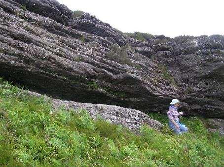
7 Historical records for Poa alpina on Mt. Brandon. Colgan Recorded from rocky tors close to the summit Recorded from low rock outcrops near summit but apparently absent from surrounding acid grassland on deeper soil.

8 Survey techniques Survey equipment 1980 s Notebook, compass, OS 6-inch maps and half inch to 1 mile maps

9 Mid to late 1990 s Notebook, GPS, aerial photographs and 1:50,000 Discovery Series maps

10 2010 onwards - Ipads, Trimbles, Bing and Google maps etc. etc.
11 Aerial photographs and rare plant recording Essential for the accurate recording of population distribution. Available from a number of sources. Ordnance Survey of Ireland, Bing Maps, Google maps. GPS points can be overlaid on aerial photos.
12 Rare plant populations what information do I collect? Species County 6" Map Discovery Map Locality/Site name Vice-county (No.) SAC/NHA Vegetation description, i.e. Releve GPS readings for the species Grid refs (GPS, National Grid) 2005 Aerial Photo Recorder(s) Synonymous habitat/vegetation types Elevation (m) Solid geology Record date Site description Population description Associated species/ vegetation Current management Threats First record and other comments References: Sketch map of population. Maps, aerial photographs and habitat photographs Conservation measures Ownership Access Other remarks
13 Estimating population size What constitutes and individual plant? Easy for annual species but difficult for spreading perennial species. Most workable approach to count the number of flowering heads and estimate the area of distribution, e.g. 30 to 35 flowering heads in an area of 3 x 6 metres. Important to note presence absence of grazing, drainage, agricultural reclamation, forestry etc. Is there previous information on the population.
14 Case histories Why are rare plants rare? Generally only grow in narrow range of habitat conditions and that habitat is generally rare. Many rare plant species are poor competitors and get outcompeted in dense vegetation. Thus drainage and lack of grazing is a problem for many.


15

16 Crambe maritima Gorumna, Co. Galway
17 Crambe maritima Sea Kale Not on FPO. Recorded from 19 10k squares in Republic of Ireland since Majority of recent records from the Cork and West Galway coastline. Declined since late 1800s but appears to have increased since the 1970 s? Main threats shingle extraction, grazing and storm damage/rise in sea-levels.
18 Crambe maritima Distribution

19 Gnaphalium sylvaticum Heath cudweed
20 Gnaphalium sylvaticum Heath cudweed On 1999 Flora Protection Order Recorded from 28? 10k squares in Republic of Ireland since <10 good records in past 10 years. Much more frequent in the early 1900 s. Drastic decline in recent decades. Main reasons decline in tillage and reclamation of waste areas.

21 Gnaphalium sylvaticum distribution

22
A SUMMARY OF THE NATIONAL SURVEY OF IRISH SAND DUNES.
 A SUMMARY OF THE NATIONAL SURVEY OF IRISH SAND DUNES. INTRODUCTION The (CMP) was carried out on behalf of the National Parks and Wildlife Service (NPWS). The project represents the first comprehensive
Parish s Alkali Grass (Puccinellia parishii)
") Parish s Alkali Grass (Puccinellia parishii) Legal Status [Species photo to come] Taxonomy State: S1 1 California Rare Plant Rank: 1B.1 2 Federal: Bureau of Land Management Sensitive Critical Habitat:
Parish s Alkali Grass (Puccinellia parishii) Legal Status [Species photo to come] Taxonomy State: S1 1 California Rare Plant Rank: 1B.1 2 Federal: Bureau of Land Management Sensitive Critical Habitat:
Genetic Diversity, conservation and crop wild relatives (CWR)
") Genetic Diversity, conservation and crop wild relatives (CWR) Progress and Perspectives: Ireland Dr Susanne Barth, Senior Research Officer 1 Public Hearing, 7 th of December 2017, Committee on Agriculture
Genetic Diversity, conservation and crop wild relatives (CWR) Progress and Perspectives: Ireland Dr Susanne Barth, Senior Research Officer 1 Public Hearing, 7 th of December 2017, Committee on Agriculture
Appendix A.8.11 A Survey of Selected Rivers for the Galway City Transport Project with Potential for Margaritifera (Moorkens, 2014a)
") Appendix A.8.11 A Survey of Selected Rivers for the Galway City Transport Project with Potential for Margaritifera (Moorkens, 2014a) A.8.11 A SURVEY OF SELECTED RIVERS FOR THE GALWAY CITY TRANSPORT PROJECT
Appendix A.8.11 A Survey of Selected Rivers for the Galway City Transport Project with Potential for Margaritifera (Moorkens, 2014a) A.8.11 A SURVEY OF SELECTED RIVERS FOR THE GALWAY CITY TRANSPORT PROJECT
Giselle Block U. S. Fish and Wildlife Service National Wildlife Refuge System Inventory and Monitoring Program
 Giselle Block U. S. Fish and Wildlife Service National Wildlife Refuge System Inventory and Monitoring Program Giselle_block@fws.gov Learning Objectives Prioritization Why its important Factors to consider
APPENDIX C REPRESENTATIVE HABITAT PHOTOGRAPHS
 APPENDIX C REPRESENTATIVE HABITAT PHOTOGRAPHS 1304 119 Combined Vegetation and TES assesment 9a 10 8b 1,2 3a 6a 6b 11 9b 3b 4b 5c, 5d 4a 5b 8a 7b 5a Appendix C. Approximate Location of Representative Habitat
Tundra Shootingstar (Dodecatheon austrofrigidum K.L. Chambers) Habitat Assessment and Surveys on the Olympic National Forest, WA
 Habitat Assessment and Surveys on the Olympic National Forest, WA") Tundra Shootingstar (Dodecatheon austrofrigidum K.L. Chambers) Habitat Assessment and Surveys on the Olympic National Forest, WA Report prepared for the Interagency Special Status / Sensitive Species Program
Tundra Shootingstar (Dodecatheon austrofrigidum K.L. Chambers) Habitat Assessment and Surveys on the Olympic National Forest, WA Report prepared for the Interagency Special Status / Sensitive Species Program
National Parks and Wildlife Service
 ISSN 2009-4086 National Parks and Wildlife Service Conservation Objectives Series Dunbeacon Shingle SAC 002280 13 Dec 2017 Version 1 Page 1 of 7 National Parks and Wildlife Service, Department of Culture,
The Marble Canyon milk-vetch. Astragalus cremnophylax var. hevronii
 The Marble Canyon milk-vetch Astragalus cremnophylax var. hevronii A 10-year Monitoring Update Redwall Site, Coconino County, AZ INTRODUCTION Daniela Roth Navajo Natural Heritage Program P.O. Box 1480
A Primer of Conservation Biology
 A Primer of Conservation Biology FIFTH EDITION Richard B. Primack Boston University Sinauer Associates, Inc. Publishers Sunderland, MA U.S.A. Contents Chapter 1 Defining Coservation Biology 3 The New Science
Threatened Plants in Britain and Ireland. Pete Stroh, BSBI
 Threatened Plants in Britain and Ireland Pete Stroh, BSBI Aims of the survey Improve knowledge concerning abundance & ecological and management requirements of threatened species Quantify the extent of
National Parks and Wildlife Service
 ISSN 2009-4086 National Parks and Wildlife Service Conservation Objectives Series Keeper Hill SAC 001197 17 Oct 2017 Version 1 Page 1 of 9 National Parks and Wildlife Service, Department of Culture, Heritage
Tree Conservation Programs Local Roots, Global Reach
 Tree Conservation Programs Local Roots, Global Reach Tree Conservation Programs Local Roots, Global Reach Tree science is The Morton Arboretum s breeding ground for discoveries, and conservation is the
RIVER BASIN PLANNING TO PROTECT OUR SHARED AQUATIC RESOURCE IN IRELAND
 Comhairle Chontae Dhún na ngall Donegal County Council www.donegal.ie RIVER BASIN PLANNING TO PROTECT OUR SHARED AQUATIC RESOURCE IN IRELAND Picture courtesy of E Moorkens River Basin Planning in Ireland
Low Northern Rockcress (Neotorularia humilis)
") The Status of Low Northern Rockcress (Neotorularia humilis) in Newfoundland and Labrador THE SPECIES STATUS ADVISORY COMMITTEE REPORT NO. 1 September 30, 2004 1 ASSESSMENT Assessment: Endangered Current
The Status of Low Northern Rockcress (Neotorularia humilis) in Newfoundland and Labrador THE SPECIES STATUS ADVISORY COMMITTEE REPORT NO. 1 September 30, 2004 1 ASSESSMENT Assessment: Endangered Current
THE FIRST IRAQI NATIONAL REPORT TO THE CONVENTION ON BIOLOGICAL DIVERSITY
 THE FIRST IRAQI NATIONAL REPORT TO THE CONVENTION ON BIOLOGICAL DIVERSITY CHAPTER I BIODIVERSITY VALUES MARSH Most Most important fresh fresh and and brackish water water system of of the the region Breeding
Site Improvement Plan. Mendip Limestone Grasslands SAC. Improvement Programme for England's Natura 2000 Sites (IPENS) Planning for the Future
 Planning for the Future") Improvement Programme for England's Natura 2000 Sites (IPENS) Planning for the Future Site Improvement Plan Mendip Limestone Grasslands Site Improvement Plans (SIPs) have been developed for each Natura
Improvement Programme for England's Natura 2000 Sites (IPENS) Planning for the Future Site Improvement Plan Mendip Limestone Grasslands Site Improvement Plans (SIPs) have been developed for each Natura
Enclosed farmland: Arable and Horticultural, Improved and Neutral Grasslands
 executive summary Executive summary 1 Countryside Survey 2000 (CS2000) and the Northern Ireland Countryside Survey 2000 (NICS2000) have been designed to provide detailed information about the habitats
Soil Conservation Survey of the Pokaiwhenua Catchment
 Environment Waikato Technical Report 2005/15 Soil Conservation Survey of the Pokaiwhenua Catchment Prepared by: Dr. Douglas Hicks For: Environment Waikato PO Box 4010 HAMILTON EAST ISSN: 1172-4005 Document
REGIONAL EXPERT ADVISORY WORKSHOP REPORT 01 MAR 2011 VIENTIANE, LAO PDR WETLANDS ECOSYSTEM SERVICES AND BIODIVERSITY AND CC
 Mekong Wetlands ecosystem services and biodiversity and Climate Change Peter-John Meynell, based on paper by Mark Bezuijen Outline Wetland Ecosystem services a means of valuing the importance of wetlands
CHANGING PHYSICAL ENVIRONMENTS. A.M. FRIDAY, 15 January hours
 GCE AS/A level 1201/01 GEOGRAPHY G1 CHANGING PHYSICAL ENVIRONMENTS A.M. FRIDAY, 15 January 2010 1 1 2 hours ADDITIONAL MATERIALS In addition to this examination paper, you will need one 12 page answer
Rangeland Conversion Study
 Homes on the Range: Trends in Conversion and Protection of Rangeland Habitat OVERVIEW Rangeland Conversion How much has been lost? What has it become? How much is protected? Importance of CA Rangelands
National Parks and Wildlife Service
 ISSN 2009-4086 National Parks and Wildlife Service Conservation Objectives Series Ballyhoura Mountains SAC 002036 Page 1 of 11 National Parks and Wildlife Service, Department of Arts, Heritage, Regional,
Relationship to E Flows
 Relationship to E Flows Riparian Areas Influences groundwater/surface water relationships Provides filters to improve water quality Provides habitat for diverse flora and fauna Relationship to E Flows
Common Name: GEORGIA PLUME. Scientific Name: Elliottia racemosa Muhlenberg ex Elliott. Other Commonly Used Names: Elliottia
 Common Name: GEORGIA PLUME Scientific Name: Elliottia racemosa Muhlenberg ex Elliott Other Commonly Used Names: Elliottia Previously Used Scientific Names: none Family: Ericaceae (heath) Rarity Ranks:
SD48. Sites List: Whitbarrow Township Allotment
 SD48 Sites List: Jun-SD4080-01 Jun-SD4086-01 Jun-SD4384-01 Jun-SD4485-01 Jun-SD4486-01 Jun-SD4487-01 Jun-SD4489-01 Jun-SD4990-01 Hampsfield Allotment Simpson Ground Yewbarrow Whitbarrow Farrers Whitbarrow
Mining History. Gold Rush in Colorado 1850s. Acid Rock Drainage. Most mining prior to current environmental regs 1970s
 Presentation Outline Colorado and Mining Challenges to Addressing Health and Environmental Impacts Agencies and Partnerships Abandoned Mine Data Hub Draining Mines Water Quality Study Akron/Tomichi Creek
Pre and Post Vegetation Management Decisions around Burning & Grazing
 Pre and Post Vegetation Management Decisions around Burning & Grazing Stephanie Larson, PhD Livestock & Range Management Advisor Sonoma & Marin Counties Prescriptive Burning Weather Fire Spread, Severity
Notes for NEPA for Generic Terms of Reference
 TERMS OF REFERENCE IIRRIIGATIION AND WATER MANAGEMENT Notes for NEPA for Generic Terms of Reference This generic Terms of Reference (TOR) is applicable to the construction and/or the development of Irrigation
E.U. Habitats and their identification
 1 E.U. Habitats and their identification A talk given by Stephen Heery to the COFORD Council Land Availability Working Group, 6 th December 2012. I must first say that these views are my own. It is a brief,
Land Use Change on Non-Federal Land in Oregon
 Land Use Change on Non-Federal Land in Oregon 1974-2014 JUNE 2016 COORDINATOR: Gary J. Lettman RESEARCHERS (Alphabetically): Andrew N. Gray (Forest Inventory and Analysis Program, Pacific Northwest Research
The BurrenLIFE Project Farming for Conservation in the Burren Brendan Dunford, James Moran
 The BurrenLIFE Project Farming for Conservation in the Burren Brendan Dunford, James Moran Overview - a brief introduction to the Burren - the role of agriculture - managing the heritage of the Burren
Alberta Conservation Information Center Ecological Community Sampling Guidelines
 Alberta Conservation Information Center Ecological Community Sampling Guidelines Updated November 2011 1. Introduction An ecological community is defined as a distinct assemblage of plant species with
Common Name: CUTLEAF BEARDTONGUE. Scientific Name: Penstemon dissectus Elliott. Other Commonly Used Names: dissected beardtongue
 Common Name: CUTLEAF BEARDTONGUE Scientific Name: Penstemon dissectus Elliott Other Commonly Used Names: dissected beardtongue Previously Used Scientific Names: none Family: Scrophulariaceae (snapdragon)
Holly Swartz and Jason Shirey
 Chapter 105 General Permits for Stream and Wetland Impacts DEP Ch. 105 CONTACTS FOR BERKS COUNTY: Holly Swartz and Jason Shirey What DEP Regulates Under Chapter 105 Waters of the Commonwealth, which includes
Phase II: Construction (See Appendix 1 for figures and photos)
") Phase I- Complete: Plan Design, Compliance and Baseline Monitoring Audubon and San Pablo Bay National Wildlife Refuge (Refuge) staff completed approximately 2 years of pre-construction monitoring including
Phase I- Complete: Plan Design, Compliance and Baseline Monitoring Audubon and San Pablo Bay National Wildlife Refuge (Refuge) staff completed approximately 2 years of pre-construction monitoring including
Forest Stewardship Program
 Forest Stewardship Program James Starr, Forest Management 06/2003 Purpose of Forest Stewardship Program is to assist private forest landowners in more actively managing their forest and related resources;
Performing Cost Effective Asset Management Inventories Utilizing GIS. Steve Tyler, Public Works Superintendent Mark Dumford, Consultant
 Performing Cost Effective Asset Management Inventories Utilizing GIS Steve Tyler, Public Works Superintendent Mark Dumford, Consultant Town of Atherton South San Mateo County 5 square miles Approximately
2. Inventory estimates for the Kyoto Protocol (WP 1.2)
") 2. Inventory estimates for the Kyoto Protocol (WP 1.2) A. M. Thomson and D. C. Mobbs Centre for Ecology & Hydrology, Bush Estate, Penicuik. 2.1 Introduction CEH produced a voluntary submission of CRF tables
2. Inventory estimates for the Kyoto Protocol (WP 1.2) A. M. Thomson and D. C. Mobbs Centre for Ecology & Hydrology, Bush Estate, Penicuik. 2.1 Introduction CEH produced a voluntary submission of CRF tables
State Forest Land in North-Central Pennsylvania
 State Forest Land in North-Central Pennsylvania Overview Map The State Forest System in Northcentral PA (shown in green) is home to a diverse assemblage of plant and animal species. As part of its mission,
A collaborative strategy for optimizing management of the river corridor. Wednesday, June 2, 2010
 A collaborative strategy for optimizing management of the river corridor. Wednesday, June 2, 2010 Lower Feather River CMP Overview Map The Aerial Photo of the entire Big Picture Lower Feather River CMP
Panther Fire Salvage Project
 Prepared by: Julie Knorr Botanist Klamath National Forest May 04, 2009 Abstract Regulatory Framework Section 7 of the Endangered Species Act of 1973, as amended, Forest Service Policy (FSM 2670), and
ELECTRICAL TRANSMISSION LINES & SUBSTATIONS
 TERMS OF REFERENCE ELECTRICAL TRANSMISSION LINES & SUBSTATIONS Notes for NEPA for Generic Terms of Reference This generic Terms of Reference (TOR) is applicable to development projects involving the construction
Densities of Wild Lupine and Karner Blue Butterflies After Reconductering the Cobb to Brickyard Line: 2007
 Densities of Wild Lupine and Karner Blue Butterflies After Reconductering the Cobb to Brickyard Line: 2007 Prepared by: Joelle Gehring, Ph.D. Michigan Natural Features Inventory Steven Mason Building,
Relicensing Study 3.5.1
 Relicensing Study 3.5.1 BASELINE INVENTORY OF WETLAND, RIPARIAN AND LITTORAL HABITAT IN THE TURNERS FALLS IMPOUNDMENT, AND ASSESSMENT OF OPERATIONAL IMPACTS ON SPECIAL-STATUS SPECIES Initial Study Report
The Living Lands Project Aimee Weldon Living Lands Project Manager
 The Living Lands Project Aimee Weldon Living Lands Project Manager Living Lands Project Defenders of Wildlife Our Mission: To support the work of local land trusts interested in conserving native wildlife
Forest Stewardship Management Plan
 Forest Stewardship Management Plan James Starr, Forest Management 06/2003 Forest Stewardship Management Plans Plans must identify and describe actions to protect, manage, maintain and enhance relevant
9/4/2013 CHAPTER 4 ECOLOGY AND GEOLOGY. Ecosystem. Ecology & Geology Linkage. Fundamental Ecology Terms. Natural Service Functions of Ecosystems
 CHAPTER 4 ECOLOGY AND GEOLOGY Ecology & Geology Linkage Ecology Study of relationships between living things and their environments; the study of control factors over the distribution, abundance, and health
Hitchcock s blue-eyed grass (Sisyrinchium hitchcockii) Habitat Restoration at Lost Creek Meadow: 2016 Annual Report
 Habitat Restoration at Lost Creek Meadow: 2016 Annual Report") Hitchcock s blue-eyed grass (Sisyrinchium hitchcockii) Habitat Restoration at Lost Creek Meadow: 2016 Annual Report 3/31/2017 2016 Annual Report. Submitted to the Bureau of Land Management, Agreement #L13AC00098-29,
Hitchcock s blue-eyed grass (Sisyrinchium hitchcockii) Habitat Restoration at Lost Creek Meadow: 2016 Annual Report 3/31/2017 2016 Annual Report. Submitted to the Bureau of Land Management, Agreement #L13AC00098-29,
2018 Arkansas State Wildlife Grant Pre-proposal
 2018 Arkansas State Wildlife Grant Pre-proposal EXPANDING PINE FLATWOODS HABITAT RESTORATION AT LONGVIEW SALINE NATURAL AREA TO BENEFIT SPECIES OF GREATEST CONSERVATION NEED Project Summary High priority
THE EARTH S BIOSPHERE
 THE EARTH S BIOSPHERE l Energy Flows in Ecological Systems l Ecosystem Structure l Productivity and Biodiversity Energy Flows in Ecological Systems Producers and Consumers l Organisms with the ability
INTRODUCTION. Why Save Endangered Trees?
 INTRODUCTION Why Save Endangered Trees? As we walk through the world every day, we are surrounded by trees and plants. They are so ubiquitous and common that we take them for granted. They are part of
Nehalem River Watershed Assessment 1
 Nehalem River Watershed Assessment 1 1.0 Introduction Purpose Watershed assessment is a process for evaluating how well a watershed is working. The purpose of this assessment was to determine how natural
Protecting Exclusion Areas
 Protecting Exclusion Areas NEFA BACKGROUND PAPER Protecting Exclusion Areas Prepared by: Dailan Pugh, 2014 The Threatened Species Licence (TSL) is required to regulate activities so as to protect State
The Proportion of Scotland's Protected Sites in Favourable Condition 2017 Evidence
 The Proportion of Scotland's Protected Sites in Favourable Condition 2017 An Official Statistics Publication for Scotland Scotland has a rich and important diversity of biological and geological natural
Figure 1: The Proportion of Features in Favourable Condition 1 at 31 st March
 The Proportion of Scotland's Protected Sites in Favourable Condition 2018 An Official Statistics Publication for Scotland Scotland has a rich and important diversity of biological and geological natural
GEARING UP FOR ATLAS 2020 ATLAS 2020
 GEARING UP FOR 1. The Atlas 2020 project 2. Updates and plans 3. Our strengths and weaknesses 4. How to address our weaknesses Aim: to provide information on the distribution of the plant species of Britain
WATER SUPPLY ASSESSMENT AND RANKING OF WATERSHED DAMS IN GEORGIA
 WATER SUPPLY ASSESSMENT AND RANKING OF WATERSHED DAMS IN GEORGIA Charles D. Absher, P.E., CFM 1, and David M. Ashley, RLA 2 AUTHORS: 1 Senior Water Resources Engineer; and 2 Vice President, respectively,
Prepared by: Rummel, Klepper & Kahl
 WETLAND DELINEATION REPORT Kutztown Road (SR 1033) Resurfacing and Bridge Replacement Upper Hanover Township, Montgomery County, Pennsylvania Prepared for: PennDOT District 6-0 Prepared by: Rummel, Klepper
SDCP Biological Goal. Biological Basis of the Sonoran Desert Conservation Plan. Approach. Planning Alternatives. Species List.
 Biological Basis of the Sonoran Desert Conservation Plan SDCP Biological Goal Ensure the long-term survival of the full spectrum of plants and animals that are indigenous to Pima County Approach Select
Appendix 11T Smooth Newt Lissotriton vulgaris
 Appendix 11T Populations of smooth newt and their habitats are considered potentially significant nature conservation receptors for the Proposed Scheme for the following reasons: The smooth newt and its
Integrated Plant Biodiversity Conservation: Its relevance in cities within biodiversity hotspots. Viloshanie Reddy
 Integrated Plant Biodiversity Conservation: Its relevance in cities within biodiversity hotspots Viloshanie Reddy Natural vegetation of a city. Important for ecosystem services in cities These service
RECOMMENDED BEST MANAGEMENT PRACTICES for Colorado green gentian (Frasera coloradensis)
") RECOMMENDED BEST MANAGEMENT PRACTICES for Colorado green gentian (Frasera coloradensis) Practices Developed to Reduce the Impacts of Road Maintenance Activities CNHP s mission is to preserve the natural
RECOMMENDED BEST MANAGEMENT PRACTICES for Colorado green gentian (Frasera coloradensis) Practices Developed to Reduce the Impacts of Road Maintenance Activities CNHP s mission is to preserve the natural
Community-level effects of fragmentation of the. afromontane grassland in the escarpment region of. Mpumalanga, South Africa
 Community-level effects of fragmentation of the afromontane grassland in the escarpment region of Mpumalanga, South Africa by DEWALD KAMFFER Submitted in partial fulfillment of the requirements for the
Understanding Climate Change Impacts and Enhancing Resilience of Cyprus Forests
 Understanding Climate Change Impacts and Enhancing Resilience of Cyprus Forests Dr. Andreas Christou Senior Conservator of Forests International Conference ADAPT to CLIMATE 27 28 March,, Filoxenia Conference
People are using many approaches to slow the rate of extinctions and to preserve biodiversity.
 Section 3: People are using many approaches to slow the rate of extinctions and to preserve biodiversity. K What I Know W What I Want to Find Out L What I Learned Essential Questions What are the two classes
New Jersey Forest Stewardship Program Spatial Analysis Project Map Products And Data Layers Descriptions
 New Jersey Forest Stewardship Program Spatial Analysis Project 2007 Map Products And Data Layers Descriptions 01/07 NJ Forest Stewardship Program (FSP) Spatial Analysis Project (SAP) Methodology Project
National Parks and Wildlife Service
 ISSN 2009-4086 National Parks and Wildlife Service Conservation Objectives Series Ballyogan Lough SAC 000019 03 May 2018 Version 1 Page 1 of 7 National Parks and Wildlife Service, Department of Culture,
FINAL REPORT. Prepared by:
 ANALYSIS OF WILLOW EXPANSION ALONG CROW CREEK ON F.E. WARREN AIR FORCE BASE, WYOMING FINAL REPORT Prepared by: Dr George P. Jones, Ecologist Wyoming Natural Diversity Database University of Wyoming P.O.
Very slight to negligible limitations no special land management practices required.
 Land Capability Classes Land and Soil Capability Class 1 Class 1 Definition Very slight to negligible limitations no special land management practices required. On-site impact of land management practices
ADOPT A RESOLUTION OF THE CITY COUNCIL IN SUPPORT OF THE CALIFORNIA WATERFIX AND CALIFORNIA ECO RESTORE
 ADOPT A RESOLUTION OF THE CITY COUNCIL IN SUPPORT OF THE CALIFORNIA WATERFIX AND CALIFORNIA ECO RESTORE Presented by Gary Takara City Council September 18, 2017 Agenda Item 12 Recommendations Find that
Twin Lakes Quarrys, Inc. P.O. Box 705 Mountain Home, AR (870)
") Twin Lakes Quarrys, Inc. P.O. Box 705 Mountain Home, AR 72654 (870) 425-4510 November 6,2006 Arkansas Department of Environmental Quality Water Division Tony L. Moms P.O. Box 8913 Little Rock, AR 72219-891
Twin Lakes Quarrys, Inc. P.O. Box 705 Mountain Home, AR 72654 (870) 425-4510 November 6,2006 Arkansas Department of Environmental Quality Water Division Tony L. Moms P.O. Box 8913 Little Rock, AR 72219-891
Monitoring Grazing Lands in Oregon 1
 Oregon State University BEEF023 Beef Cattle Library Beef Cattle Sciences Monitoring Grazing Lands in Oregon 1 Dustin D. Johnson 2 Introduction A critical, but often overlooked step in the development of
FIGURE 11 ENLOW FORK MITIGATION BANK COUNTY NATURAL HERITAGE INVENTORY MAP WASHINGTON COUNTY, PENNSYLVANIA. Feet. Miles
 25 5 Feet.5.1 Miles Document Path: Y:\84\33362-RES_2WAS2_Carpent\GIS\Enlow Fork- RES\Figure - Enlow Fork MB County Natural Heritage Inventory Map.mxd Legend Core Habitat Landscape Conservation Area Provisional
Previously Used Scientific Names: Oxypolis filiformis (Walter) Britton var. canbyi Coulter & Rose
 Britton var. canbyi Coulter & Rose") Common Name: CANBY S DROPWORT Scientific Name: Oxypolis canbyi (Coulter & Rose) Fernald Other Commonly Used Names: Canby's cowbane Previously Used Scientific Names: Oxypolis filiformis (Walter) Britton
Common Name: CANBY S DROPWORT Scientific Name: Oxypolis canbyi (Coulter & Rose) Fernald Other Commonly Used Names: Canby's cowbane Previously Used Scientific Names: Oxypolis filiformis (Walter) Britton
Jones Ridge Grow Site Complex Reclamation Operation Synopsis. April 19 and 20, 2018
 Jones Ridge Grow Site Complex Reclamation Operation Synopsis April 19 and 20, 2018 Prepared by: Dr. Greta Wengert and Dr. Mourad Gabriel Integral Ecology Research Center: IERCecology.org In the summer
Appendix C Risk Assessment Methods
 Appendix C Risk Assessment Methods The following section outlines the specific methods, data, and values used to evaluate wildfire risk in Lane County. Identifying the Wildland Urban Interface Risk The
MODULE : ECOLOGY
 MODULE 021131: ECOLOGY Learning Objectives: Lecture 1? Ecology covers a hierarchy of levels of organisation, from individual to biosphere? There are distinctive (emergent) properties of ecological systems
1) Brief description of the event/incident description
 Brief description of the event/incident description") Case Study Report: Ireland 2015, Killarney fire investigation Adding value with a European Forest Risk Facility Purpose: Case study reports are a tool to investigate and document how a European Forest
Case Study Report: Ireland 2015, Killarney fire investigation Adding value with a European Forest Risk Facility Purpose: Case study reports are a tool to investigate and document how a European Forest
IDENTIFICATION AND MANAGEMENT OF SPECIES AND PLANT COMMUNITIES AT RISK: BC TIMBER SALES PRINCE GEORGE BUSINESS AREA
 The following descriptions about ranking species and plant communities have been provided verbatum for informational purposes from the following location: NatureServe. 2007. NatureServe Explorer: An online
Appendix 2. Summary of the U.S. Fish and Wildlife Service 2010 Warranted but Precluded Determination
 Appendix 2. Summary of the U.S. Fish and Wildlife Service 2010 Warranted but Precluded Determination This appendix contains a summary of the U.S. Fish and Wildlife Service (USFWS) 12-month findings for
Glendree Bog SAC (site code ) Conservation objectives supporting document - blanket bogs and associated habitats NPWS.
 Conservation objectives supporting document - blanket bogs and associated habitats NPWS.") Glendree Bog SAC (site code 001912) Conservation objectives supporting document - blanket bogs and associated habitats NPWS Version 1 January 2019 Contents 1 Introduction... 1 1.1 Glendree Bog SAC... 2
Glendree Bog SAC (site code 001912) Conservation objectives supporting document - blanket bogs and associated habitats NPWS Version 1 January 2019 Contents 1 Introduction... 1 1.1 Glendree Bog SAC... 2
A remnant patch is either:
 The removal of native vegetation has been regulated in Victoria under the Planning and Environment Act since 1989. This is not new legislation. It is legislation you should already be aware of and working
Rural Development Programming: Expereinces from Ireland Dr. Alex Copland
 Rural Development Programming: Expereinces from Ireland Dr. Alex Copland A background to rural Europe Widespread loss of biodiversity Loss of threatened habitats Pressures on water quality and quantity
Initial results of leather-leaf (Chamaedaphne calyculata) and speckled alder (Alnus rugosa) cutting regime on plant biodiversity on Cranberry Bog
 and speckled alder (Alnus rugosa) cutting regime on plant biodiversity on Cranberry Bog") Initial results of leather-leaf (Chamaedaphne calyculata) and speckled alder (Alnus rugosa) cutting regime on plant biodiversity on Cranberry Bog Soren Dahl 1 INTRODUCTION Cranberry Bog spans 70 acres
Initial results of leather-leaf (Chamaedaphne calyculata) and speckled alder (Alnus rugosa) cutting regime on plant biodiversity on Cranberry Bog Soren Dahl 1 INTRODUCTION Cranberry Bog spans 70 acres
FINAL WILDLIFE and VEGETATION RESOURCES STUDY PLAN. Blue Lake Hydroelectric Project FERC No Expansion. Prepared by:
 FINAL WILDLIFE and VEGETATION RESOURCES STUDY PLAN Blue Lake Hydroelectric Project FERC No. 2230 Expansion Prepared by: City and Borough of Sitka, Electric Department 105 Jarvis Street Sitka, Alaska 99835
APPENDIX B. MARINE RIPARIAN INVENTORY FOR SAN JUAN COUNTY
 APPENDIX B. MARINE RIPARIAN INVENTORY FOR SAN JUAN COUNTY Introduction Riparian vegetation provides important habitat and process functions to freshwater and marine systems, including microclimate, structure,
OKLAHOMA DEPARTMENT OF AGRICULTURE, FOOD AND FORESTRY 2800 N. Lincoln Boulevard, Oklahoma City, OK PRESS RELEASE: FOR IMMEDIATE RELEASE
 OKLAHOMA DEPARTMENT OF AGRICULTURE, FOOD AND FORESTRY 2800 N. Lincoln Boulevard, Oklahoma City, OK 73105-4912 PRESS RELEASE: FOR IMMEDIATE RELEASE January 23, 2018 FOR MORE INFORMATION CONTACT: Scott Alls,
Northamptonshire Biodiversity Records Centre
 Northamptonshire Biodiversity Records Centre Colin Wilkinson Harpole Parish Council 76 Larkhall Lane Harpole Northampton NN7 4DF Northamptonshire Biodiversity Records Centre C/O The Wildlife Trust Lings
Bushfire-Prone Area Assessment Report
 Bushfire-Prone Area Assessment Report Brompton Lodge, Cranbourne 7 May 2013 Bushfire Prone-Area Assessment Report Brompton Lodge, Cranbourne Date of Inspection: 10 th April, 2013 Prepared For: Clients
natural landscape, in particular throughout the boreal forest. In an effort to better understand
 Boreal Chickadee [Poecile hudsonicus] Distribution & Habitat Associations in Alberta The Boreal Chickadee is a common, iconic and well-loved feature of Canada s natural landscape, in particular throughout
3.3.3 Landscape-Directed Soil Sampling
 12 3 Soil Sampling and Analysis 3.1 Principles of Soil Sampling Soil sampling and analysis is the only way to determine the available nutrient status of a field and to receive field-specific fertilizer
GENERAL GUIDELINES FOR CONDUCTING THREATENED AND ENDANGERED SPECIES SURVEYS IN THE PINELANDS AREA. March 25, 2006 INTRODUCTION
 GENERAL GUIDELINES FOR CONDUCTING THREATENED AND ENDANGERED SPECIES SURVEYS IN THE PINELANDS AREA March 25, 2006 INTRODUCTION This document is intended to provide general guidance for use in conducting
3. Present Situation of Environmental Problems
 3. Present Situation of Environmental Problems 3.1 Natural Environment The goals, issues and programmes regarding the natural environment of the Ten Year Perspective Development Plan 2001-2011 are shown
Peer review of submittal documents for the Fairhaven Highlands Project as they relate to Plants and Animals
 5309 Shilshole Avenue NW Suite 200 Seattle, WA 98107 206.789.9658 phone 206.789.9684 fax www.adolfson.com memorandum date to from cc subject Vikki Jackson, Northwest Ecological Services, LLC Lara Thoreson
Desert Cymopterus (Cymopterus deserticola)
") Desert Cymopterus (Cymopterus deserticola) Legal Status State: None California Rare Plant Rank: 1B.2 1 Federal: Bureau of Land Management Sensitive Critical Habitat: N/A Recovery Planning: N/A Photo courtesy
Desert Cymopterus (Cymopterus deserticola) Legal Status State: None California Rare Plant Rank: 1B.2 1 Federal: Bureau of Land Management Sensitive Critical Habitat: N/A Recovery Planning: N/A Photo courtesy
Densities of Wild Lupine and Karner Blue Butterflies After Reconductering the Cobb to Brickyard Line: 2010
 Densities of Wild Lupine and Karner Blue Butterflies After Reconductering the Cobb to Brickyard Line: 2010 Prepared by: Joelle Gehring, Ph.D. Michigan State University Michigan Natural Features Inventory
Latest lakeshore vegetation survey and an update on willow control
 Latest lakeshore vegetation survey and an update on willow control Jodi Rees Environment Canterbury Te Waihora Living Lake Symposium, 9 10 November 2017, Lincoln University Photo: Alice Shanks April 2017
Translocation, Restoration and Management Methods for Otay tarplant (Deinandra conjugens), Challenges and Lessons Learned
, Challenges and Lessons Learned") Translocation, Restoration and Management Methods for Otay tarplant (Deinandra conjugens), Challenges and Lessons Learned Southern California Grassland Symposium March 22, 2012 The Project Included Habitat
Translocation, Restoration and Management Methods for Otay tarplant (Deinandra conjugens), Challenges and Lessons Learned Southern California Grassland Symposium March 22, 2012 The Project Included Habitat
Environmental Impact Statement for the Slave Falls Tramway Conversion Project
 Environmental Impact Statement for the Slave Falls Tramway Conversion Project Prepared for Submitted by 41844.101 March 2008 ENVIRONMENTAL IMPACT STATEMENT FOR THE SLAVE FALLS TRAMWAY CONVERSION PROJECT