CITY OF OAK FOREST Community Development Department
|
|
|
- Alannah Cox
- 6 years ago
- Views:
Transcription

1 CITY OF OAK FOREST Community Development Department REQUEST FOR PROPOSALS TRANSIT-ORIENTED DEVELOPMENT OF THE GATEWAY RFP Issued: April 18, 2014 Submission Due: May 31, 2014
2 The Table of Contents I. Introduction... Page 3 II. Background Page 4 III. Community, Market, Site... Page 6 IV. Project Site Description.. Page 7 V. City Development Objectives & Requirements.. Page 8 VI. Submittals Page 11 VII. Exhibits Page 14 Page 2

3 I. INTRODUCTION The City of Oak Forest, Illinois is seeking a developer to purchase and redevelop a multi-family residential/mixed use parcel and commercial parcel at the intersection of 159th Street and Cicero Avenue, immediately adjacent to the Oak Forest Metra station, commonly referred as the Gateway Corridor. The parcel consists of 4.9 acres and is planned and zoned for medium high density apartment/condos with the opportunity of first floor commercial units. The City is seeking a mixed use, destination-oriented project that must include residential components and parking, and may also include retail and accessory parking. For complete site and project description, see Gateway Development Background. This request is intended to invite proposals that shall include design concepts and development plans for the site that advance the goals and concepts identified in the Gateway Redevelopment Plan, highlights of which are attached hereto. The City acknowledges that the ultimate design project is a collaborative effort and the City will work with the selected developer in a timely manner relative to any proposed public/private partnership. This report and other relative information about the City can be viewed at To be considered, interested parties should submit a response to this request to the City, in accordance with the submittal requirements set out in Section 3 hereof. Page 3
4 II. BACKGROUND The City of Oak Forest seeks a public/private partnership to develop the Gateway, a mixed-use residential and retail transit-oriented development (the Project ). The proposed development is desired by the City in order to set an example for the standard of future commercial and residential development in the 159th Street and Cicero Avenue area, as well as supplement the Gateway area with a new demographic that s both younger with a higher level of median household income. The location of the site is a gateway to Oak Forest, sitting at the intersection of the city s major commercial and transportation corridors. The Gateway Corridor is located at the intersections of 159th Street and Cicero Avenue, approximately 22 miles southwest of Chicago s Loop. The Project is at the location of the east entrance to the City of Oak Forest and the commuter train station that serves approximately 1,600 weekday commuters on Metra s Rock Island District Line, which runs between Joliet and Downtown Chicago. The mixed-use, transit-oriented project envisions using the Metra Station as the focal point of the development, which required the Station s relocation to the north so that it is centered within the site. The new retail and residential buildings are strategically placed to emphasize the importance of the station. Significant public/private funding has been invested with the intention that the uses and upscale nature of the project will provide a catalyst for new development and contribute to the general redevelopment of the neighborhood. During weekends and holidays, the site will be transformed into city center where the City of Oak Forest and the Oak Forest Park District will host events and public gatherings, such as farmer s markets and community gatherings. As part of the Gateway marketing, the city envisions catering to the young, working professional who will utilize all the different amenities this project has to offer, i.e. transit, residential development, recreation, proximity to entertainment and shopping. Another major amenity that will be available is the 1 gigabit broadband that is currently being implemented. The city believes this T.O.D. project should take full advantage of the 1 gigabit broadband access that will be available on the site to attract the young professional that can utilize this amenity for remote work, business start-up or for entertainment purposes. The mixed-use, transit-oriented development is being developed in two phases: Phase 1 Phase 1 of the Project is complete and involved the purchase of an obsolete school on the south side of 159th Street and directly across the street from the existing Metra Station and parking lot. The school was demolished and a new 450 car Metra parking lot was created. An antenna tower that was located within the existing Metra parking lot was relocated, and the existing parking lot was demolished. This work also included the preservation of the designated wetland, the Page 4
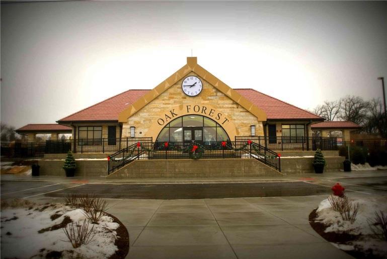
5 installation of a storm trap system capable of storing up to an acre-foot of storm water, the underground utilities required for the balance of the development, including the preparation of three outlot retail pads, on-grade retail parking for 248 cars, a kiss- and-ride turnabout for the new Metra station, and landscaping throughout the site. This Phase also included the relocation, repaving and construction of an increased number of handicapped parking spaces along the west side of the site and directly adjacent to the Metra Station. This Phase required a total investment of $10.7 million. Two of the pads were developed with a bank and a CVS Drugstore. The remaining retail outlot has space for a 12,000 square foot building and is planned for restaurant and service retail. Phase 2 Phase 2 of the development is planned for 128 market rate luxury apartment units in 2 adjacent 5-story buildings. Each building is designed with 64 apartments. The first floor of each building will contain approximately 3,700 square feet of retail space with the balance of the space dedicated to parking for the apartment units. The project contains on-grade retail parking for 248 cars. The residential apartment buildings are located to the west of the site near the Metra station at the corner of 159 Street and Cicero Avenue providing extraordinary visibility to the 34,000+ cars in all four directions. The residential buildings are designed as two 5 story buildings with retail and parking on the first level and second floor with market rate residential units on floors 3 thru 5. The site work in place includes all utility requirements, storm water detention, and some site landscaping. There are no environmental issues on the site. Metra Station Design The new Metra Station was situated to provide a catalyst for the redevelopment of the neighborhood. It is expected that during weekends and holidays, the Metra Station will be transformed into a type of city center where Oak Forest will host events and public activities, such as farmer s markets and community gatherings. The new station was completed in 2013 and is now fully functional. The elevations below show the placement of the Station within the Gateway development and illustrate its significant architectural details and elongated canopies with prominent columns and integrated landscaping. A warming shelter is also in place to the south of the Station. Page 5
6 III. COMMUNITY, MARKET, SITE The City of Oak Forest is a community with a strategic location in the south suburban Chicago area. (Exhibit 1). Situated just 22 miles southwest of Chicago s downtown loop, 35 minutes from O Hare International Airport and Chicago s Midway Airport, and surrounded by major transportation routes, Oak Forest is perfectly located for business and residential users within the Chicagoland area. Two I-57 interchanges are accessible within 1.9 miles from the Gateway corridor that offers immediate access within minutes to I-80 and I-294. Over 1,600 commuters per weekday utilize the convenient and frequent Metra Rock Island train that provides transit to Chicago within less than 40 minutes from the Oak Forest station. Oak Forest is the home to many amenities that separate this city from other communities in the local area. With its above average school districts and 6,000 acres of connected forest preserve and 20+ miles of looped trails, Oak Forest can provide for strong education from grammar school to high school with opportunities of higher education, while also providing an escape from the average city/suburban life into nature all in the Oak Forest citizen s backyard. The city continues to work with the Cook County Forest Preserve to provide for different programs, such as sculling and ziplining that will make the many passive recreation areas more of an active environment. The amenities of education and recreation are a great blend to what the future holds for Oak Forest s commercial districts. The Gateway acts as the central pivot point for two commercial corridors along 159 th Street and Cicero Ave. The 159 th commercial corridor offers medium to high density multi-family developments near the Metra station with general commercial business stretching west down the corridor. The Cicero Avenue commercial district acts as the central business district of the city providing for entertainment and shopping. The city continues to take an aggressive approach revitalizing these commercial corridors. Two TIF districts have been established allowing the city to provide incentives and infrastructure improvements, such as the Cicero Ave streetscape project. Demographics Total Population: Approximately 28,000 Median Household Income: $68,595 Median Age: 35.3 Other Oak Forest attributes include a well-established park district with over ten parks in the city, a private catholic school, a library, an award winning George W. Dunne National public golf course and over 500 commercial, professional and industrial businesses. Page 6
7 IV. PROJECT SITE DESCRIPTION a. Site Profile The Gateway Corridor is located at the NW corner of the Cicero Avenue and 159 th Street intersection. This property anchors both the 159 th Street commercial district and the heavily commercial Cicero Avenue corridor with city plans to supplement this correlation between the Gateway and these commercial corridors. The site has excellent frontage along both thoroughfares and is centrally located with proximity to retail, office, and the Metra Rock Island station (Exhibit 2). The subject property is surrounded by a blend of commercial, residential and open space. The west consists of medium-high density apartment complexes and the 159 th St. commercial corridor. Across 159 th Street to the south will be a blend of commercial businesses, Metra parking, and future low-density multi-family housing on city-owned property. The Cook County Forest Preserve owns the bulk of the land to the east with the Oak Forest Hospital at the SE corner of the intersection. The north of the subject property is a blend of housing and the Cicero Ave. business district. The Wille Brothers concrete plant is currently in the process of proposing some alternatives for their exit from the train station area. The City is working closely with the Wille to provide certainty to the future redevelopment of the site. The project site is build-ready with roadway and utility infrastructure in place and two multifamily building pads ready for development. The site will also have access to 1 gigabit broadband that is part of the I-57 broadband project. The total project area is approximately 4.9 acres in area with 840 of frontage along 159 th Street and 910 of frontage along Cicero Avenue. The two multi-family area building pads are split with a kiss-and- ride commuter drop-off area between and adjacent waiting spaces. b. Tax Increment Financing District The development site is in the City of Oak Forest Tax Increment Financing District 3. This TIF District was initiated in 2003 and will extend to Funds from this TIF are available to assist with short term reinvestment in the proposed Gateway project, as well as for enhancing the current surrounding properties, streetscapes and the like. The sale of city-owned property and any companion Development Agreements which are aided by TIF funds must be in conformity with the TIF statute, where applicable. The City will work with the selected developer to assist as possible with the proposed development. Assistance may include an attractive site purchase price, TIF assistance as warranted and allowed by statute, neighborhood improvements, and required site or area infrastructure improvements. Types and amounts of assistance available are negotiable, based on long term benefit of the development to the City. Page 7
8 c. Zoning The underlying zoning for this site is C-3 Central Business District and is governed by this district as well as the overlay zoning district, the Gateway Sub-Area district. Permitted uses for first floor commercial units shall be limited to the uses listed in Appendix A of the zoning ordinance. However, the site is presently regulated in accordance with a Planned Unit Development ordinance and Development Agreement enacted specifically for the Gateway project as presently envisioned. Changes in that plan would require an amendment to the existing P.U.D. and Development Agreement. Should the selected developer seek to change the existing plan, any new plan would be subject to a P.U.D. agreement with the City. Such agreement would require Site Development Plan Review for all phases of the project. Special permits are required for parking decks and first floor residential uses. It will be the Applicant s responsibility to finance and secure any and all variations, special permits, site development plan approval, and all other approvals that may be required. The P.U.D. general requirements would not mandate building or parking setbacks for the subject property, but does require the following minimum bulk standards for new development: The Village s Zoning Ordinance mandates the following parking requirements: 2.5 parking spaces per unit; Eating and drinking 1 per 2 employees, PLUS 1 per 3 persons of design capacity; Retail & 1 space per 250 SF of net floor area. It should be noted that parking and bulk standards can be deviated from through the P.U.D. process that provides the development with flexibility. This flexibility, however, can only be utilized when the developer has displayed a creative approach to the overall development by promoting unique use of the land/development, architectural features and functions. Please refer to Section of the City of Oak Forest Zoning Ordinance for additional information regarding the Gateway Redevelopment Sub-Area. A copy of the City of Oak Forest Zoning Ordinance is available online at V. CITY DEVELOPMENT OBJECTIVES & REQUIREMENTS As shown in the attached drawings, and Gateway Executive Summary, the site has previously been planned for the development of two sixty-four unit apartment buildings, three commercial parcels and access and drop-off areas for the adjacent Metra station. Two of the commercial parcels have been developed with a CVS drug store, and a branch bank. The City was an active partner in the design of the plan and would like the development completed as presently planned. However, changes in the specific design of the proposed buildings may be acceptable so long as the overall density and theme of the development do not stray substantially from the attached Page 8
9 plan. The following themes are an integral part of the Village s plan for redevelopment of the subject property. A. Mixed-Use Development/Commercial Lot Understanding the market place will dictate the type of development (condo vs. apartment) that will be successful in this area; the city is looking for a developer that will think outside of the box creating a unique mixed-use, transit-oriented development that separates itself from the typical suburbia condo/apartment development. The first step in the right direction would be to utilize the amenities of the area, such as the bike trails and gigabit broadband access. Through these amenities, a developer could provide a live/work complex that could provide the gigabit access along with amenities such as meeting rooms that can be digitally scheduled by the residents and have the same functions as a typical office space, i.e. projector screen and equipment, conference calling availability - and/or providing work or office space area that allows residents to hardline into the gigabit broadband to complete their work in the form of a business incubator type setting. The Forest Preserve trails, as well as the city bike routing, is one of the best amenities Oak Forest has to offer. The Gateway development should capitalize on this by creating a bike-share program of some kind that allows residents of the facility to rent or sign out a bike, or work with the city to attract a bike shop and supplement the shop to allow residents of the complex discounting on rentals, repairs or purchases. Sustainability is a key element to the Gateway Corridor. The city has attained a technical assistance grant through Global Green who will provide the city this summer with a sustainability plan for this area. The city s ultimate goal is to eventual attain a LEED Neighborhood Certification. While the architecture will be important in this endeavor, the function of the development will be just as important. On top of the bike share program, the city would like to work with the developer of the Gateway to provide an I-GO/Zipcar program. City staff has already initiated talks with a provider of such a program who has shown interest to create a partnership in the southland. As stated previously in this document, the end result is to engage the young professional that wants the ability to hike/bike through open space, work from home in a manner many cannot in the Chicago area, and has commercial/retail opportunities right outside their door. The Community Development Department of the city has continued to seek a gastropub-type restaurant that gives commuters and residents of not only the complex, but the city, a great eating experience that again is unique to the area and matches the character of the of the mixed-use development as a whole. Page 9
10 B. Quality Architecture Architecture and urban design are especially important at this location. The project design must be characterized with visual interest by high quality design, materials, and site amenities. One aspect to encompass this visual interest is the incorporation of green features. These types of features will correlate the architecture with the community s forest preserves and open space, while adding to the overall sustainability of the design. Such green elements could include rain gardens, green roofs, and planting bed balconies. Creativity is essential and key to this development as a whole. The uniqueness of the functionality should be matched by its physical presence. A visual compatibility with the train station should be achieved on some level, but the development should hold its own distinct character. C. Engineering The City supports efforts to incorporate environmentally sensitive and sustainable components into the development plans. The City has planned this area as part of a mass transit oriented development with local parking and walkways focused on the adjacent Metra station. Any selected plan/developer must include these sustainable elements. D. Pedestrian and Open Space Central Oak Forest is a transportation-oriented environment. The development plan must take into consideration the auto, bicycle and pedestrian experience as it relates to, but not limited to, accessing mass transit via streetscapes, signage, greenways, landscaping and other tangible elements. The development plan can address the opportunity for an interactive, high quality residential and commercial area. Incorporating interactive public open space which encourages social networking, civic engagements and outdoor enjoyment that creates a civic or passive use space for the surrounding area is desired. The Village anticipates that the planned improvements of existing plazas and the additional public open space for this development will be visible, inviting and will produce viable options for pedestrians to visit, gather and interact with others, and are to include seating and lighting. These concepts will be addressed by the municipality with regard to the surrounding neighborhood, and should be tied to the Gateway project by the selected developer. Public art is also encouraged around the Metra station and would be a welcome component of the development plan. The City supports any artistic expression that would enliven the public space/development and bring people together. It is expected that any public art installation Page 10
11 would provide unique character to the area and could brand the area as a gathering place. Public art could be in the form of sculpture, monuments, fountains, and murals. E. Consistency with Municipal Plan and Codes The development shall comply with all applicable City of Oak Forest codes and ordinances, including, but not limited to: zoning (unless zoning relief is granted), stormwater regulations, building and life safety. Oak Forest codes can be found on the City s website at V. CITY OF OAK FOREST PARTICIPATION The redevelopment of this property is an essential part of the community s efforts to not only beautify the area with new development, but to bring development as a whole to a new level in Oak Forest both commercially and residentially. The Gateway will act as a catalyst to this necessary endeavor and the city will continue to supplement this movement. Oak Forest has continued to demonstrate its willingness to partner in the redevelopment of this corridor by purchasing infill redevelopment residences, implementing improvements of the city streetscape and creating city owned and maintained public parking lots. The city continues to pursue control of other parcels needing to be repositioned within the Oak Forest marketplace. Those who provide proposals to the city are invited to investigate the City s plans for other surrounding properties. SUBMITTAL REQUIREMENTS The following information, to be delivered in a sealed packet marked Gateway RFP, must be included in the submittal response: A. A letter of introduction signed by the principal(s) of respondent firm(s). B. Statement of understanding and presentation of project concept: Discuss the significance of the project s site and the project itself, the firm s willingness to negotiate a potential private/public partnership with the City; and the respondent s view of the responsibility of the parties in the potential public-private partnership. In addition, to the extent that the proposed development differs from the plans previously approved for Gateway, respondents must submit illustrations of their development concepts with concept-level site plans and sketches, accompanied by a detailed redevelopment concept statement to include proposed uses, square footages and/or unit count, potential phasing and a preliminary financial pro forma. This presentation of project concept is not binding on the specifics of eventual proposal submittals. Rather, it is intended to demonstrate the respondent s initial concepts and/or programmatic response to the City s Gateway development vision. C. Preliminary Estimate of Public Participation Requested: Each respondent must include a preliminary estimate of the amount of public participation requested and how that Page 11
12 participation fits within the overall preliminary pro forma of the project. In addition, the respondent must indicate which development components the requested public participation would help to finance. D. Estimate of Economic Impacts: A preliminary estimate of both direct and indirect economic impacts from the project should be provided. Direct impacts would include projected commercial and service sales and jobs, as well as the property, sales, utility and real estate excise taxes arising from them. Indirect impacts include estimates of induced development and/or induced commercial activity as a result of the project. E. Respondent s information: Name, addresses, and phone numbers of firm(s) responding (include contact information for each member if the development team includes a partnership of multiple firms developer and each member firm of the consultant team); Description of form of organization (corporation, partnership, etc.); statement of years the firm has been in business under current name and a list of other names under which the firm has operated. F. Résumés of firm(s) principals and officers and consultant principals to be involved. G. Description of relevant experience of the respondent firm. H. Project Examples: List and briefly describe relevant, successfully completed, mixed-use and/or urban projects that demonstrate strong integration of uses and/or with the surroundings, quality of design, attention to detail, integration into existing community fabric, and public-private partnering. Project examples may be from individual experience of the principals or from firm projects. At a minimum, include examples of projects from the respondent. I. References: For each firm, submit a minimum of three (3) references from public agencies, private companies, or individuals with whom respondent has had relevant experience. J. Include contact names, addresses and telephone numbers. SUBMITTAL DEADLINE RFP responses must be received by the City of Oak Forest at the office set out below no later than 5:00 pm on May 31, 2014, unless the deadline is extended by the City. Respondents are asked to submit 12 copies of all proposal materials, along with one copy in digital/electronic format (PDF), via , to the person/address listed below. Submit all materials to: Name: Adam E. Dotson Title: Community Development Director Agency: City of Oak Forest, Illinois Page 12
13 Address (mail or deliveries): City of Oak Forest, S. Central Avenue, Oak Forest, IL Inquiries regarding all aspects of this RFP should be directed to: Adam Dotson, Community Development Director City of Oak Forest, S. Central Avenue, Oak Forest, IL Phone: (708) ext Pre-Submittal Meeting A pre-submittal meeting may be called by the City depending on the number of inquiries and/or requests for the information prior to the RFP submittal deadline. City Discretion and Authority (Terms and Conditions) A. The City may accept such responses as it deems to be in the public interest and furtherance of the purposes of the City of Oak Forest, or it may proceed with additional selection processes. B. The City reserves the right to reject any and all RFP respondents at any time, to waive minor irregularities and to terminate any negotiations implied in this RFP or initiated subsequent to it. C. The City reserves the right to request clarification of information submitted, and to request additional information from any respondent. D. The City reserves the right to revise this RFP, including the submittal deadline and the RFP evaluation process. Such revisions will be announced in writing to all RFP respondents. E. The issuance of the RFP and the receipt and evaluation of submissions do not obligate the City to select a developer and/or enter into project-specific negotiations. F. The City will not be responsible for costs incurred in responding to this RFC. G. The City may cancel this process or the subsequent project-related processes at any time prior to the selection of any respondent without liability. Page 13

14 Exhibit List I. Regional Map. E-1 II. Location Map..... E-2 III. Development Plan... E-3 IV. Gateway Development Background E-4 - Gateway Project Rendering - Gateway Project Various Perspectives V. Housing Study E-5 Page 14

15 The Gateway T.O.D. Oak Forest, IL Regional Map Exhibit 1 Page 15

16 Exhibit 2 The Gateway, a transit-oriented development in Oak Forest, Illinois Location Map Page 16

17 Exhibit 3 The Gateway, a transit-oriented development in Oak Forest, Illinois Development Plan Page 17


18 Exhibit 4 Various Perspectives Page 18
19 Exhibit 5 Housing Study Page 19
If you have any questions about the request for proposal, please contact me by at
 Cuyahoga County Land Reutilization Corp. 323 W. Lakeside Avenue, Suite 160 Cleveland, Ohio 44113 Tel (216) 698-8853 Fax (216) 698-8972 October 23, 2017 RE: Request for Development Proposals 14501 Kinsman
Vero Beach Vision Plan
 Vero Beach Vision Plan City of Vero Beach, Florida Prepared in cooperation with: The Vero Beach Vision Team and The Citizens of Vero Beach Prepared by: Gould Evans Associates 4041 Mill Street Kansas City,
Tenth Community Meeting
 Welcome Tenth Community Meeting September 23 rd, 2008 Organized by: Office of Neighborhood Services Greater Forest Hills Area Task Force Massachusetts Bay Transportation Authority Boston Redevelopment
B-2 COMMUNITY COMMERCIAL BUSINESS DISTRICT. Uses allowed in the B-2 Community Commercial Business District are subject to the following conditions:
 SECTION 46-53.1 B-2 COMMUNITY COMMERCIAL BUSINESS DISTRICT A. PURPOSE The B-2 Community Commercial Business District is oriented toward retail, service businesses and multi-family residential development.
ARTICLE IV. ZONING DISTRICTS DIVISION 9. M-X MIXED USE DISTRICT. (2) Ensure sensitivity to the surrounding neighborhood;
 Ensure sensitivity to the surrounding neighborhood;") ARTICLE IV. ZONING DISTRICTS 36-263 DIVISION 9. M-X MIXED USE DISTRICT Sec. 36-261. Purpose. The purposes of the M-X mixed use district are to: (1) Provide areas for mixed use development that are carefully
ARTICLE IV. ZONING DISTRICTS 36-263 DIVISION 9. M-X MIXED USE DISTRICT Sec. 36-261. Purpose. The purposes of the M-X mixed use district are to: (1) Provide areas for mixed use development that are carefully
Wheaton PRELIMINARY RECOMMENDATIONS
 Wheaton PRELIMINARY RECOMMENDATIONS Wheaton Finding the right balance of land uses within the diversity unique to Wheaton Wheaton s Role in the County Wheaton + Silver Spring = full set Services employment,
Request for Proposals (RFP) for DDA Consultant Services
 for DDA Consultant Services") Request for Proposals (RFP) for DDA Consultant Services Issued Population (2010 census) 2,454 No. of Households 731 SUMMARY The Charter Township of Royal Oak Downtown Development Authority (DDA) requests
Request for Proposals (RFP) for DDA Consultant Services Issued Population (2010 census) 2,454 No. of Households 731 SUMMARY The Charter Township of Royal Oak Downtown Development Authority (DDA) requests
Request for Qualifications (RFQ) Purchase and Redevelopment of Tracts D, E and Q
 Purchase and Redevelopment of Tracts D, E and Q") Request for Qualifications (RFQ) 18-0143 Purchase and Redevelopment of Tracts D, E and Q Issued: November 19, 2018 Responses due no later than: December 21, 2018 1 EXECUTIVE SUMMARY The City of Richland,
Request for Qualifications (RFQ) 18-0143 Purchase and Redevelopment of Tracts D, E and Q Issued: November 19, 2018 Responses due no later than: December 21, 2018 1 EXECUTIVE SUMMARY The City of Richland,
New Downtown Lisle TIF District Created What are the Opportunities for You?
 New Downtown Lisle TIF District Created What are the Opportunities for You? Capitalizing on the exciting opportunities in award-winning Downtown Lisle, Marquette Investments plans to break ground on a
THE NUCLEUS INNOVATION AND RESEARCH PARK PARKING GARAGE
 REQUEST FOR DESIGN-BUILD PROPOSALS THE NUCLEUS INNOVATION AND RESEARCH PARK PARKING GARAGE Lump Sum Proposal ISSUED TUESDAY, JUNE 10, 2014 RESPONSES DUE WEDNESDAY, JULY 2, 2014 BY 4:00 PM EDT TABLE OF
VILLAGE OF FRANKFORT REQUEST FOR PROPOSAL FOR PROFESSIONAL PLANNING SERVICES TO PREPARE A COMPREHENSIVE PLAN
 VILLAGE OF FRANKFORT REQUEST FOR PROPOSAL FOR PROFESSIONAL PLANNING SERVICES TO PREPARE A COMPREHENSIVE PLAN I. Purpose of Proposal The requests proposals from planning and design consultants to complete
Department of Planning Services Division of Planning SARAH E. KEIFER, AICP Phone: 302/ Director of Planning Services FAX: 302/
 Kent County Department of Planning Services Division of Planning SARAH E. KEIFER, AICP Phone: 302/744-2471 Director of Planning Services FAX: 302/736-2128 KRISTOPHER S. CONNELLY, AICP Assistant Director
Priority Redevelopment Sites
 Priority Redevelopment Sites Downtown Petoskey There are two main focus areas for downtown redevelopment: 200 East Lake Street and the Michigan Street Parking Lot (Darling Lot). Although these two distinct
Greater Cleveland Regional Transit Authority
 Greater Cleveland Regional Transit Authority CALL FOR ARTISTS - PUBLIC ART CLIFTON ENHANCEMENT PROJECT CFA NO. 1-2014 Due Date: Friday, March 14, 2014 4:00 P.M. Official Time February 14, 2014 Prospective
City of Valdosta Land Development Regulations
 Section 210-3 Urban Commercial Corridor Overlay District (A) Purpose. The purposes of the Urban Commercial Corridor Overlay District are to: (1) Promote the general health, safety, and welfare of the community.
Request for Interest. A New and Innovative Water Vessel Operation on The Woodlands Waterway
 Request for Interest A New and Innovative Water Vessel Operation on The Woodlands Waterway in The Woodlands, Texas Issuance Date: February 21, 2019 Due Date: May 31, 2019 1 Request for Interest Water Vessel
PLANNING & DEVELOPMENT DEPARTMENT STAFF REPORT SLX DCI MAJOR MODIFICATION AND VARIANCE
 PLANNING & DEVELOPMENT DEPARTMENT Meeting Date: April 16, 2019 Item #: PZ2019-439 Project Name: Applicant: Owner: STAFF REPORT SLX DCI MAJOR MODIFICATION AND VARIANCE Proposed Development: Requests: Site
Notwithstanding article VII of this chapter, the following conditional uses may be permitted in the planned mixed use development (PMUD) zone:
 zone:") DIVISION 14. - PLANNED MIXED USE DEVELOPMENT (PMUD) Sec. 78-1021. - Purpose. The town is a community with a rich tradition of mixed use neighborhoods and a paucity of land area dedicated for large commercial,
DIVISION 14. - PLANNED MIXED USE DEVELOPMENT (PMUD) Sec. 78-1021. - Purpose. The town is a community with a rich tradition of mixed use neighborhoods and a paucity of land area dedicated for large commercial,
Request for Proposals Redevelopment of the White Street Municipal Parking Lot
 Request for Proposals Redevelopment of the White Street Municipal Parking Lot Block 31, Lot 2.01 Borough of Red Bank Monmouth County New Jersey Submission Deadline: Tuesday, April 26, 2017, 10:00 a.m.
2016 MAJOR GENERAL PLAN AMENDMENT
 2016 MAJOR GENERAL PLAN AMENDMENT GROWTH AREAS ELEMENT GROWTH AREAS ELEMENT 4.0 GOALS 1. Encourage orderly development within Growth Areas. 2. Encourage balanced, mixed use and multi-modal development
FOR SALE FOR SALE COMMERCIAL / MIXED USE LAND $239,000. John Jensen Judy Walsh
 Pequot Commercial COMMERCIAL / MIXED USE LAND FOR SALE > 0.96 acre parcel with 200 road frontage > House on parcel will need to be torn down > Close to turn-about of Route 2 and 184 > Zone Economic Development
ARTICLE 9 INDUSTRIAL
 ARTICLE 9 INDUSTRIAL Sec. 29.900. INDUSTRIAL BASE ZONES. (1) Purpose. The industrial base zones established by this Ordinance are General Industrial (GI) Zone and Planned Industrial (PI) Zone. Each of
Davis Garden TIF District: Overview and Taylor Farms, I-30 Frontage Road, and Kessler Theater Projects
 Davis Garden TIF District: Overview and Taylor Farms, I-30 Frontage Road, and Kessler Theater Projects Economic Development Committee November 2, 2009 1 Purpose Review three proposals for TIF funding in
COUNTY OF ALBEMARLE PLANNING STAFF REPORT SUMMARY
 COUNTY OF ALBEMARLE PLANNING STAFF REPORT SUMMARY Project Name: SP 2010-00006, Baugh Auto Body; SP 2010-00011 Baugh Rental Car Outdoor Storage Planning Commission Public Hearing: July 27, 2010 Owners:
PARCEL P-12 DEVELOPMENT & URBAN DESIGN GUIDELINES
 PARCEL P-12 DEVELOPMENT & URBAN DESIGN GUIDELINES Development Guidelines Parcel P-12 is an approximately 30,000 square feet parcel located in the South Cove Urban Renewal Area, owned by the Boston Redevelopment
Valparaiso Transit Center
 Valparaiso Transit Center Project History Site Location Valparaiso Transit Center Design Objectives Primary Task: Development of a Transit Hub on ANCO Property Supplemental Tasks: Long-Term Vision for
La Grange Public Library Request for Proposal Executive Search Firm
 La Grange Public Library Request for Proposal Executive Search Firm Please return all Proposals by January 19, 2018 4:30 pm CST to: La Grange Public Library Personnel Committee 10 West Cossitt Ave. La
Corridor Commercial Suburban District Regulations City of St. Petersburg City Code Chapter 16, Land Development Regulations
 16.20.090 - Corridor Commercial Suburban District ( CCS ) CCS-1 CCS-2 Figure REFERENCE Typical Buildings in the CCS District INSERT DRAWING: SITE PLAN OF A TYPICAL SUBURBAN COMMERCIAL CORRIDOR DEVELOPMENT
# Mercyhealth Hospital Project Review for Planning and Zoning Commission
 #2017-38 Mercyhealth Hospital Project Review for Planning and Zoning Commission Meeting Dates: December 6, 2017 and January 3, 2018 Requests: 1. Preliminary Planned Unit Development and 2. Special Use
Special Use Permit Application Martin Street Property
 Special Use Permit Application Martin Street Property Submitted to City of Reno February 08, 2016 Prepared for PCD Asset Group 2760 Camino Diablo Walnut Creek, CA 94597 Prepared by Martin Street Property
City Commission Workshop
 Causeway Boulevard Corridor Study City of Dunedin, Florida City Commission Workshop January 10, 2012 Causeway Boulevard Corridor Study City of Dunedin, Florida Workshop Agenda Where we re at in the process.
TAX INCREMENT FINANCING (TIF) ASSISTANCE. Application Packet
 ASSISTANCE. Application Packet") TAX INCREMENT FINANCING (TIF) ASSISTANCE Application Packet 1 General Application Information The Tax Increment Financing program is designed to serve the diverse needs of the business community and to
TAX INCREMENT FINANCING (TIF) ASSISTANCE Application Packet 1 General Application Information The Tax Increment Financing program is designed to serve the diverse needs of the business community and to
SECTION 8. COMMERCIAL ZONING DISTRICTS
 SECTION 8. COMMERCIAL ZONING DISTRICTS 8.1 COMMERCIAL ZONING DISTRICTS PURPOSE STATEMENTS 8.2 PERMITTED AND SPECIAL USES 8.3 BULK AND SETBACK REGULATIONS 8.4 COMMERCIAL DISTRICT DESIGN STANDARDS 8.5 GENERAL
Village of Cary, Illinois. Economic Development Plan. December 2013
 Village of Cary, Illinois Economic Development Plan December 2013 VILLAGE OF CARY ECONOMIC DEVELOPMENT PLAN 2013 Introduction In August, 2013, the Village Board hosted an Economic Development workshop.
Plaza 3 Urban Renewal Plan
 Plaza 3 Urban Renewal Plan Aurora, Colorado November 2015 Prepared for: Aurora Urban Renewal Authority Aurora, Colorado City Council Plaza 3 Urban Renewal Plan Aurora, Colorado Table of Contents Section
The ARDEN Group Development Standards 05/17/13 Rezoning Petition No (University City Auto Mall) Site Development Data:
 Site Development Data:") The ARDEN Group Development Standards 05/17/13 Rezoning Petition No. 2013-052 (University City Auto Mall) Site Development Data: --Site Acreage: +/- 39 Ac. --Tax Parcel #: 047-23-108 --Existing Zoning:
The ARDEN Group Development Standards 05/17/13 Rezoning Petition No. 2013-052 (University City Auto Mall) Site Development Data: --Site Acreage: +/- 39 Ac. --Tax Parcel #: 047-23-108 --Existing Zoning:
Addison LLC Project. Central Business District. City Council and Community Presentation December 6, 2010
 Addison LLC Project Central Business District City Council and Community Presentation December 6, 2010 CBD TIF I Original Project Area Established by Ordinance O-17-86 (With Sales Tax District) TIF I:
CONDITIONS OF APPROVAL. ATWORTH COMMONS PRELIMINARY PLAT and PLANNED UNIT DEVELOPMENT PPU & PPL th Court SW
 CONDITIONS OF APPROVAL EXHIBIT D ATWORTH COMMONS PRELIMINARY PLAT and PLANNED UNIT DEVELOPMENT PPU-14-0001 & PPL-14-0001 5601 216 th Court SW SEE RECORDED COA AFN 201503160430 CONDITIONS OF APPROVAL CITY
Community Vision and Core Values DRAFT SEPTEMBER 2013
 Community Vision and Core Values DRAFT SEPTEMBER 2013 Introduction Plan Rapid City is the effort to update the Rapid City Comprehensive Plan, a long-range planning strategy that will provide a blueprint
Historic Fire Department Property Development Opportunity
 Historic Fire Department Property Development Opportunity Request for Proposals (RFP) June 1, 2016 City of Highwood 17 Highwood Avenue Highwood, IL 60040 INTRODUCTION Mayor Charles Pecaro and the Highwood
REQUEST FOR PROPOSAL WAYFINDING SIGN DESIGN AND FABRICATION FOR THE CITY OF SALIDA, COLORADO
 REQUEST FOR PROPOSAL WAYFINDING SIGN DESIGN AND FABRICATION FOR THE CITY OF SALIDA, COLORADO I. INVITATION AND INTENT The City of Salida invites all interested, qualified persons or firms capable of providing
Plaza 4 Urban Renewal Plan
 Plaza 4 Urban Renewal Plan Aurora, Colorado November 2015 Prepared for: Aurora Urban Renewal Authority Aurora, Colorado City Council Plaza 4 Urban Renewal Plan Aurora, Colorado Table of Contents Section
North Woodbridge Urban Mixed Use Master Zoning Plan
 North Woodbridge Urban Mixed Use Master Zoning Plan 18 October 2005 Project Team: Potomac Communities A premier residential, business and visitor location on the Potomac River 2004-2008 Strategic Plan
VILLAGE COMMONS URBAN RENEWAL AREA URBAN RENEWAL PLAN PREPARED FOR: ARVADA URBAN RENEWAL AUTHORITY
 VILLAGE COMMONS URBAN RENEWAL AREA URBAN RENEWAL PLAN PREPARED FOR: ARVADA URBAN RENEWAL AUTHORITY AUGUST 22, 2008 Village Commons Urban Renewal Area Urban Renewal Plan Prepared For: Arvada Urban Renewal
3.8 LAND USE AND PLANNING
 3.8 LAND USE AND PLANNING 3.8.1 INTRODUCTION This section evaluates the potential land use and planning impacts of the proposed project. The section describes the existing and surrounding land uses at
CONCEPTS Village of Allouez, Wisconsin OCTOBER 16, 2018
 CONCEPTS Village of Allouez, Wisconsin OCTOBER 16, 2018 2 OCTOBER 2018 VILLAGE OF ALLOUEZ CONCEPTS INTRODUCTION EXISTING All flourishing communities have a core district where residents can satisfy their
Chapter 4: Transportation and Land Use
 Chapter 4: Transportation and Land Use Transportation and land use together make possible the wide range of destination opportunities in the region. Transportation provides the connections, and, in turn,
Cliff View Project Fort Worth Avenue TIF District. Economic Development Committee April 4, 2016
 Fort Worth Avenue TIF District Economic Development Committee April 4, 2016 Rationale for Funding Reconsideration Council previously approved project subsidy up to $4,650,000 in TIF Funding on May 28,
Traverse City Downtown Development Authority TAX INCREMENT FINANCING & DEVELOPMENT PLAN #97
 Traverse City Downtown Development Authority TAX INCREMENT FINANCING & DEVELOPMENT PLAN #97 Revised April 30, 2015 TABLE OF CONTENTS INTRODUCTION! 1 DEVELOPMENT PLAN! 2 TAX INCREMENT FINANCING PROCEDURE.!
Exhibit C: Design Review & Document Approval Procedures
 Exhibit C: Design Review & Document Approval Procedures 1. INTRODUCTION This Kendall Square Urban Renewal Plan Design Review and Document Approval Procedure, (DRDAP) sets forth the procedure for design
CITY OF PORTLAND, TEXAS
 CITY OF PORTLAND, TEXAS REQUEST FOR QUALIFICATIONS FOR PLANNING SERVICES OLDE TOWN MIXED USE DISTRICT REDEVELOPMENT PLAN CITY OF PORTLAND, TEXAS 1900 Billy G. Webb Drive Due Date: Portland, Texas 78374
FOR SALE FOR SALE COMMERCIAL / MIXED USE LAND $159,000. Judy Walsh Heather Gianacoplos
 Pequot Commercial COMMERCIAL / MIXED USE LAND FOR SALE > 0.96 acre parcel with 200 road frontage > House on parcel will need to be torn down > Close to turn-about of Route 2 and 184 > Zone Economic Development
PLANNING COMMISSION STAFF REPORT APRIL 21, 2016
 Community Development Department Planning Division 1600 First Street + P.O. Box 660 Napa, CA 94559-0660 (707) 257-9530 PLANNING COMMISSION STAFF REPORT APRIL 21, 2016 AGENDA ITEM 8.B. 16-0018 BOUNTY HUNTER
Project Plan for TAX INCREMENTAL FINANCE DISTRICT #41 (UNIVERSITY-WHITNEY) City of Madison
 City of Madison") Project Plan for TAX INCREMENTAL FINANCE DISTRICT #41 (UNIVERSITY-WHITNEY) City of Madison Prepared by: Department of Planning and Community and Economic Development Economic Development Division Office
Project Plan for TAX INCREMENTAL FINANCE DISTRICT #41 (UNIVERSITY-WHITNEY) City of Madison Prepared by: Department of Planning and Community and Economic Development Economic Development Division Office
DESIGN REVIEW COMMITTEE AGENDA ITEM
 DESIGN REVIEW COMMITTEE AGENDA ITEM AGENDA DATE: NOVEMBER 16, 2016 TO: THRU: FROM: SUBJECT: Chair Fox and Members of the Design Review Committee Anna Pehoushek, Assistant Community Development Director
CRYSTAL CITY, POTOMAC YARD, AND PENTAGON CITY TAX INCREMENT FINANCING AREA
 CRYSTAL CITY, POTOMAC YARD, AND PENTAGON CITY TAX INCREMENT FINANCING AREA Our Mission: To provide a supplemental financial mechanism for the revitalization of Crystal City, Potomac Yard, and Pentagon
Project Plan for TAX INCREMENTAL FINANCE DISTRICT #41 (UNIVERSITY-WHITNEY) City of Madison
 City of Madison") Project Plan for TAX INCREMENTAL FINANCE DISTRICT #41 (UNIVERSITY-WHITNEY) City of Madison Prepared by: Department of Planning and Community and Economic Development Economic Development Division Office
Project Plan for TAX INCREMENTAL FINANCE DISTRICT #41 (UNIVERSITY-WHITNEY) City of Madison Prepared by: Department of Planning and Community and Economic Development Economic Development Division Office
4: Transportation and Land Use
 Chapter Figure 4-1: Recent development has brought more housing and mixed use Downtown Minneapolis - looking north from E 15th Street at the Grant Street / 11th Street exit 4: Transportation and Land Use
wheaton s future Wheaton s Role in the County
 wheaton s future Wheaton is envisioned as a major mixed-use center for the Georgia Avenue corridor and eastern Montgomery County. It will have regional shopping, culturally diverse retail and entertainment,
PLANNED UNIT DEVELOPMENT & SUBDIVISION STAFF REPORT Date: July 11, 2013
 PLANNED UNIT DEVELOPMENT & SUBDIVISION STAFF REPORT Date: July 11, 2013 SUBDIVISION NAME DEVELOPMENT NAME LOCATION Northside LTD/Joint Venture Subdivision, Resubdivision of and Addition to Lot 3A Northside
REPORT TO PLANNING AND DESIGN COMMISSION City of Sacramento
 REPORT TO PLANNING AND DESIGN COMMISSION City of Sacramento 915 I Street, Sacramento, 95814-2671 www.cityofsacramnto.org 9 PUBLIC HEARING November 17, 2016 To: Members of the Planning and Design Commission
TOWN OF BRUNSWICK, MAINE
 TOWN OF BRUNSWICK, MAINE INCORPORATED 1739 DEPARTMENT OF PLANNING AND DEVELOPMENT 85 UNION STREET, SUITE 216 BRUNSWICK, ME 04011 ANNA M. BREINICH, FAICP PHONE: 207-725-6660 DIRECTOR OF PLANNING & DEVELOPMENT
REQUEST FOR PROPOSALS Bond Underwriting Services
 REQUEST FOR PROPOSALS Bond Underwriting Services Denver Urban Renewal Authority 9 th and Colorado TIF Broadway Station TIF Proposals Due February 24, 2017 Responses must be prepared according to this Request
CRA DISTRICT MAP. KISSIMMEE CRA - Volume III - Architectural Standards
 CRA DISTRICT MAP The CRA District Map identifies the boundaries of four general districts: A- Gateway District, B- Mixed Employment District, C- Courthouse District, D - Neighborhood District. For properties
CITY OF ST. MICHAEL WRIGHT COUNTY, MINNESOTA ORDINANCE NO THE CITY COUNCIL OF THE CITY OF ST. MICHAEL HEREBY ORDAINS:
 CITY OF ST. MICHAEL WRIGHT COUNTY, MINNESOTA ORDINANCE NO. 1507 AN ORDINANCE AMENDING SECTION 155.073 OF THE ST. MICHAEL CODE TO ADD DEFINITIONS FOR SOLAR ENERGY SYSTEMS, AND ADD COMMUNITY SOLAR GARDEN
Request for Qualifications for. Professional Services. Franklin Urban Sports and Entertainment (FUSE) Traffic Data Collection
 Traffic Data Collection") Request for Qualifications for Professional Services Franklin Urban Sports and Entertainment (FUSE) Traffic Data Collection Gastonia, North Carolina JANUARY 4, 2019 1 I. INTRODUCTION / BACKGROUND The City
Request for Qualifications for Professional Services Franklin Urban Sports and Entertainment (FUSE) Traffic Data Collection Gastonia, North Carolina JANUARY 4, 2019 1 I. INTRODUCTION / BACKGROUND The City
Commercial Tax Abatement
 A confirmation letter is issued by the City upon receipt of this application. This application is not effective and not considered filed until the confirmation letter has been issued. Filing does not assure
EXHIBIT V G LEHIGH ACRES DESIGN STANDARDS CHECKLIST LEHIGH ACRES PLANNING COMMUNITY
 EXHIBIT V G LEHIGH ACRES DESIGN CHECKLIST LEHIGH ACRES PLANNING COMMUNITY a. b. c. a. b. c. a. b. c. COMMERCIAL DESIGN AND SPECIFICATIONS - BASIC ELEMENTS [LCLDC Section reference] Parking. In addition
University North Park TIF Project. City of Norman, Oklahoma TIF District No. 2
 University North Park TIF Project City of Norman, Oklahoma TIF District No. 2 WHAT IS A TIF? TIF is short for tax increment finance districts. These are development tools authorized by state law for cities
Request for Qualifications (RFQ)
") Request for Qualifications (RFQ) City of Brunswick, Georgia (Stage One of Two-Stage RFQ/RFP Qualifications-Based Competitive Process) Submit your Qualifications to: City of Brunswick Attn: Arne Glaeser
Request for Qualifications (RFQ) City of Brunswick, Georgia (Stage One of Two-Stage RFQ/RFP Qualifications-Based Competitive Process) Submit your Qualifications to: City of Brunswick Attn: Arne Glaeser
Corridor Residential Suburban District Regulations City of St. Petersburg City Code Chapter 16, Land Development Regulations
 Section 16.20.070 - Corridor Residential Suburban Districts ( CRS ) Sections: Typical Buildings in the CRS District 16.20.070.1 Composition of Suburban Residential Corridors 16.20.070.2 Purpose and Intent
PERMITTED USES: Within the MX Mixed Use District the following uses are permitted:
 6.24 - MX - MIXED USE DISTRICT 6.24.1 INTENT: The purpose of the MX Mixed Use District is to accommodate the development of a wide-range of residential and compatible non-residential uses (including major
Olde Town Station Urban Renewal Plan
 Olde Town Station Urban Renewal Area urban renewal plan october 2009 as amended june 2010 OldeTownArvada_Cover_Rev072110.indd 3 7/21/2010 9:57:44 AM Olde Town Station Urban Renewal Plan Prepared for: Arvada
Chapter Six Future Transportation and Land Use
 Chapter Six Future Transportation and Land Use Master Thoroughfare Plan Purpose The purpose of the Master Thoroughfare Plan is to determine the size and distribution of the roadway network, taking into
Sign Tool Kit for Local Area Businesses Village of Arlington Heights Prepared by the Planning & Community Development Department January 2010
 Sign Tool Kit for Local Area Businesses Village of Arlington Heights Prepared by the Planning & Community Development Department January 2010 table of contents 1 2 INTRODUCTION & ADVICE ON SIGNS... page
1.0 INTRODUCTION A. PURPOSE OF THE DRAFT EIR 1-1
 1.0 INTRODUCTION This Draft Environmental Impact Report (Draft EIR or EIR) has been prepared for the 1020 S. Figueroa Street Project (the Project). Jia Yuan USA Co., Inc., the Applicant, proposes to develop
Transit Revitalization Investment Districts Planning and Implementation of Act 238 of 2004
 Transit Revitalization Investment Districts Planning and Implementation of Act 238 of 2004 A Training Program Provided by the Pennsylvania Department of Community and Economic Development (DCED) February/March
South Suburban Retail Investment Study Steering Committee. Jan. 14 th, 2011 Matteson, IL. Agenda
 South Suburban Retail Investment Study Steering Committee Jan. 14 th, 2011 Matteson, IL Agenda Redlining Hypothesis Development Update SWOT Analysis Market Share Analysis Shopping Center Design Charrette
Request for Proposals: Tax Increment Financing District Application Services Response Date: December 11, 2009, 2:00 PM
 Website: www.cedoburlington.org Request for Proposals: Tax Increment Financing District Application Services Response Date: December 11, 2009, 2:00 PM I. PURPOSE The city of Burlington's Community and
Revenues and expenditures increase based on the tax district increase due to increases in real estate assessments in CY 2016 compared to CY 2015.
 CRYSTAL CITY, POTOMAC YARD, AND PENTAGON CITY TAX INCREMENT FINANCING AREA Our Mission: To provide a supplemental financial mechanism for the revitalization of Crystal City, Potomac Yard, and Pentagon
Staff has reviewed your application for the proposed mixed-use Planned Development at
 Meagan Jones Planning and Zoning Division Community Development Department 2100 Ridge Avenue Evanston, Illinois 60201 T 847.448.8170 F 847.448.8126 TTY 847.448.8052 Email: mmjones@cityofevanston.org www.cityofevanston.org
Gingellville Village Center Overlay District
 Section 33.00 Preamble The encompasses the area as illustrated on the Charter Township of Orion Zoning Map. The purpose of the shall be to promote the development of the area in accordance with the Gingellville
Zoning Code Sustainability Ideas
 Zoning Code Sustainability Ideas In October 2008, the Zoning Code Rewrite Advisory Committee (ZCRAC) approved an approach to gathering information on sustainability issues that should be considered in
Slide 1: CTA Blue Line Forest Park Branch Feasibility/Vision Study
 Slide 1: CTA Blue Line Forest Park Branch Feasibility/Vision Study Village of Forest Park Council Meeting Presented by Carole Morey, CTA Chief Planning Officer October 13, 2015 Slide 2: Purpose and Study
HIGHLAND COMMONS TAX INCREMENT FINANCING PLAN PICAYUNE, MISSISSIPPI 2015
 HIGHLAND COMMONS TAX INCREMENT FINANCING PLAN PICAYUNE, MISSISSIPPI 2015 1 HIGHLAND COMMONS TAX INCREMENT FINANCING PLAN PICAYUNE, MISSISSIPPI 2015 ARTICLE I. PURPOSE AND INTENT Section 1.01 Preamble.
Architectural Review Board Report
 Architectural Review Board Report To: From: Cc: Subject: Architectural Review Board Architectural Review Board Meeting: July 31, 2017 Agenda Item: 7.8 Russell Bunim, Associate Planner Stephanie Reich,
ANNUAL DEVELOPMENT ACTIVITY AND DISCLOSURE REPORT $4,115,000 CITY OF WHEELING, WEST VIRGINIA STONE BUILDING RENOVATION PROJECT SERIES 2005 A BONDS
 ANNUAL DEVELOPMENT ACTIVITY AND DISCLOSURE REPORT $4,115,000 CITY OF WHEELING, WEST VIRGINIA STONE BUILDING RENOVATION PROJECT SERIES 2005 A BONDS FOR THE PERIOD ENDING DECEMBER 31, 2008 Prepared by: MUNICAP,
SIGN REGULATIONS ZONING CODE Standards for Commercial and Residential Signs
 SIGN REGULATIONS ZONING CODE 153.205 Standards for Commercial and Residential Signs Signs provide direction, information, and advertising for businesses and residents. Signs must adhere to Zoning Ordinance
Article 12. Commercial Zoning Districts C-1, Central Business District. C-2, Limited Neighborhood Commercial District
 Article 12 Commercial Zoning Districts Section 12.100 Section 12.101 Section 12.102 C-1, Central Business District C-2, Limited Neighborhood Commercial District C-3, General Commercial District 12.100
DESIGN REVIEW COMMITTEE AGENDA ITEM
 DESIGN REVIEW COMMITTEE AGENDA ITEM AGENDA DATE: NOVEMBER 15, 2017 TO: THRU: FROM: SUBJECT: Chair Imboden and Members of the Design Review Committee Anna Pehoushek, Assistant Community Development Director
Request for Proposals: Retail Market Assessment & Implementation Strategy
 Request for Proposals: Retail Market Assessment & Implementation Strategy Release Date: August 24, 2017 Questions Due: September 7, 2017 Answers Provided: September 14, 2017 Proposals Due: September 21,
Transportation Category. New Location and. Green Vehicles. Reduced Parking Footprint. Bicycle Facilities. Access to Quality Transit
 New Location and Transportation Category LEED ND Location Sensitive Land Protection High Priority Site Surrounding Density Diverse Uses Access to Quality Transit Bicycle Facilities Reduced Parking Footprint
ONLY ONLY BUILDING AND PARKING ENVELOPE RZ-1 RAMP STAIRS NEW SURFACE PROPOSED HOTEL PARKING PROPOSED TWO STORY PARKING STRUCTURE NEW SURFACE PARKING
 E G DRIV EXISTIN O REMAIN ST ACCES 0' PUBLIC SPACE WITH SITE AMENITIES LOCATION MAP RAMP STAIRS SIDEWALK AND PLANTING STRIP. SIDEWALK TO MEANDER TO MAXIMIZE THE PRESERVATION OF EXISTING TREES ONLY ONLY
SADDLE CREEK CSD LANDSCAPE ARCHITECT REQUEST FOR PROPOSALS. (Boilerplate language, map and other contract language to be added on approval of Board)
") October 17, 2017 SADDLE CREEK CSD LANDSCAPE ARCHITECT REQUEST FOR PROPOSALS (Boilerplate language, map and other contract language to be added on approval of Board) PROPOSAL SUBMITTALS DUE NOVEMBER 17,
October 17, 2017 SADDLE CREEK CSD LANDSCAPE ARCHITECT REQUEST FOR PROPOSALS (Boilerplate language, map and other contract language to be added on approval of Board) PROPOSAL SUBMITTALS DUE NOVEMBER 17,
The Van Aken District
 The Van Aken District Our Vision: Van Aken District ~ A vibrant walkable mixed use district ~ Interesting buildings and landscape ~ Central green gathering place ~ Iconic Transit Station ~ Unique Retail
A PPEARANCE REVIEW BOARD
 Staff Report A PPEARANCE REVIEW BOARD FEBRUARY 19, 2015 Case Number AGENDA ITEM 2 100 W. LIVINGSTON ST. ACE CAFÉ RENOVATION ARB2015-00007 Applicant Tim Lemons, AIA L2 Studios, Inc. Property Location 100
Lake Street Apartments - Phase 1 Minneapolis, MN
 GARFIELD AVENUE HARRIET AVENUE WEST LAKE STREET CONTEXT MAP N 1 Lake and Harriet, looking northeast Lake St at alley east of Harriet, looking northwest From alley east of Harriet, looking southwest From
Community Development Department Council Chambers, 7:30 PM, July 20, 2017
 STAFF REPORT 2017-26P: Special Use Permit Community Development Department Council Chambers, 7:30 PM, July 20, 2017 To: From: Re: Paul Luke, Chairman, Skokie Plan Commission Steve Marciani, AICP, Planning
HISTORIC DISTRICT BOARD OF REVIEW SAVANNAH HISTORIC DISTRICT Instructions for Certificate of Appropriateness Application
 HISTORIC DISTRICT BOARD OF REVIEW SAVANNAH HISTORIC DISTRICT Instructions for Certificate of Appropriateness Application This document is for information purposes only and does not need to be submitted
Land Use Vision and Transportation Strategy
 Phase 1: Land Use and Transportation Strategy June 3, 2015 ing Workshop #2 Phase 1: Land Use and Transportation Strategy Welcome March 12 Workshop Summary Discussion Strategies to Implement the Next Steps