Larimer County Fire Plan
|
|
|
- Erika Martin
- 5 years ago
- Views:
Transcription
 Kathay Rennels, Larimer County")

1 Larimer County Fire Plan Prepared By: Tony Simons, Larimer County Wildfire Safety Specialist June 2003-updated 02/04, 07/05, 06/06 Special Thanks To: Tom Bender, Larimer County Commissioner (Former) Kathay Rennels, Larimer County Commissioner Don Griffith, Larimer County Emergency Services Mike Babler, Colorado State Forest Service Ellen Hodges, United States Forest Service Jesse Duhnkrack, Rocky Mountain National Park Dan Kunis, Larimer County GIS Specialist County Fire Plan 6/16/2006 1
2 Table of Contents Mission Statement... 3 Introduction... 4 Authority... 5 Larimer County Characteristics... 5 Geography... 5 Land Ownership... 6 Fire History... 6 Larimer County Wildland Fire Hazard Identification... 7 Wildland Fire Hazard Area... 7 Wildland Fire Hazard Maps... 7 Interagency Cooperation... 8 Larimer County Coordinating Group..9 Agency Responsibilities... 9 Prevention... 9 Preparedness... 9 Mitigation...10 Suppression-- Wildland Fire...10 Reclamation/Rehabilitation...11 Fiscal...11 Community Wildfire Protection Plans Template Colorado State Forest Service Minimum Standards.16 Fire Planning Categories...18 Current County-Policy with regard to state and private lands...19 Wildland Fire Use Agency Roles and Responsibilities...20 Prescribed Fire Agency Roles and Responsibilities...24 County Fire Plan Layout...26 Activity Submittal Form...27 Management Objectives...28 Prevention: 19 Preparedness:...31 Mitigation:...37 Suppression:...43 Reclamation/Rehabilitation.35 Fiscal:...47 Maps...48 Larimer County Location...48 Larimer County Land...49 Larimer County Residential Improvement...50 Larimer County Fire Protection Districts...51 Larimer County Wildfire Hazard Area...52 Larimer County Wildfire Hazard...53 Larimer County Fire Plan Strategies...54 Appendix I...55 Agreements...55 Appendix II...60 Memorandum of Understanding...60 County Fire Plan 6/16/2006 2
3 Mission Statement To provide a cooperative framework under which fire management programs are developed and implemented to protect human and natural resource values in an effective and efficient manner. County Fire Plan 6/16/2006 3
4 Introduction In 2000, the Colorado Legislature passed legislation clarifying responsibilities for wildland fire management in the State. House Bill 1283 redefined the responsibilities of County Sheriffs, the State Board of Agriculture, and the State Forester from preventing and controlling wildland fires to managing them. The Bill authorized Boards of County Commissioners to cooperate in managing as well as preventing and suppressing forest fires. The legislation authorized counties to prepare and implement a County Fire Plan. The Larimer County Fire Plan is intended to aid in the implementation of a seamless, coordinated effort between all relevant agencies in determining appropriate combinations of wildland fire management actions and programs in the county. The Larimer County Fire Plan outlines six interagency management objectives that are necessary to achieve and implement effective wildland fire management programs: prevention, preparedness, mitigation, suppression, reclamation /rehabilitation and fiscal. This plan identifies the roles and responsibilities of Larimer County, the United States Forest Service Arapaho Roosevelt National Forest, Canyon Lakes Ranger District (ARNF), Colorado State Forest Service-Fort Collins District (CSFS) and Rocky Mountain National Park (RMNP), specifies contacts for each agency, and lists interagency agreements to meet these objectives. See Appendix I. Activities needed to achieve the objectives are identified and prioritized. Each activity listed contains a brief description of the issue, background information, and specifies agencies involved, estimated costs, funding sources and estimated completion date. Additionally, this Fire Plan is intended to assist landowners/managers in identifying and mitigating wildland fire hazard areas on public and private land and to work cooperatively in developing mitigation options to reduce the impact of a wildland fire. The Larimer County Fire Plan is a dynamic document. Activities are expected to be added or deleted under each management objective as the issues within the County change or activities are completed. County Fire Plan 6/16/2006 4
5 Authority The Larimer County Fire Plan is being prepared and implemented between various governmental authorities under a Memorandum of Understanding. This agreement establishes a mutual commitment to the mission and objectives outlined in the Larimer County Fire Plan to facilitate interagency collaboration in the implementation of a wildland fire program in Larimer County. See Appendix II. Larimer County Characteristics Geography Larimer County is located in north central Colorado. It is the seventh largest county in Colorado based on population and ninth largest in area. According to 2000 census data, 251,226 people reside in Larimer County, with 68,819 residing in unincorporated areas. The county extends to the eastern edge of the Continental Divide, and includes several mountain communities and Rocky Mountain National Park. The county encompasses 2,640 square miles, about 60 miles long by 50 miles wide. Over 50% of Larimer County is publicly owned, most of which is land within the Arapaho - Roosevelt National Forest and Rocky Mountain National Park. In addition to these federal lands, Colorado State Parks and Recreation Areas, Larimer County Parks and local parks within urban areas combine to provide a wide spectrum of recreational opportunities for both residents and visitors. The elevation ranges from a low of 4,800 feet on the plains, to 13,562 feet on the high mountain peaks. See Map--Larimer County Location. The county is quite diverse topographically. The terrain includes low river valleys, flat plains, rolling hills, scenic ranch lands, forests, and rugged mountains. The irrigated land some of the finest irrigated farmland in Colorado -- lies in a narrow belt in the eastern portion of the county adjacent to streams. The dry cropland lies along the foothills and on the high ridges between river valleys. On the plains, the average annual rainfall is 14.4 inches, with an average annual snowfall of 45 inches. The average frost-free period is from 100 to 140 days. County Fire Plan 6/16/2006 5
6 Land Ownership Larimer County consists of 1,689,600 acres, of which 870,775 acres are privately owned 645,400 acres are managed by the USFS, 143,100 acres are managed by RMNP, and 27,600 acres are managed by the Bureau of Land Management (BLM), and 2725 acres are managed by CSFS. See map--larimer County Land. Over 11,000 platted parcels exist within the designated Larimer County Wildfire Hazard Area and are therefore exposed to potential wildland fire hazards. See Map--Larimer County Residential Improvement. Structures are present on about half of these parcels. Additionally, there are an estimated 172,700 acres of private land intermixed within the forest boundary. Fire protection within the county is provided by 18 professional and volunteer fire departments, the Larimer County Sheriff s Department, USFS, CSFS and RMNP. See Map--Larimer County Fire Protection Districts. Fire History Wildland fire occurrence in Larimer County is tracked by three agencies. The Arapaho-Roosevelt National Forest records fire data from national forest lands. Colorado State Forest Service (CSFS) keeps records of fires on state and private lands Rocky Mountain National Park collects fire information within the Park Boundary. CSFS statistics only reflect those wildland fires reported by local fire departments. Unfortunately, not all fire departments submit incident reports to the Colorado State Forest Service (Farmer 1998). As with most natural events, wildland fire appears to be cyclical. Statistics indicate the annual number of wildland fires peaks every six to eight years. An average of 161 wildfires occur annually in Larimer County. Although these fires burn an estimated 2209 acres each year, most of the losses occur in one-or two-year periods every eight to nine years (Farmer 1998). Records provided by the Arapaho-Roosevelt National Forest show that 55% of all wildland fires are human-caused. The remaining 45% are lightning-ignited. Historically, on state and private lands in Colorado, 49% of all wildland fires are human-caused and 11% are started by lightning. Though the cause County Fire Plan 6/16/2006 6
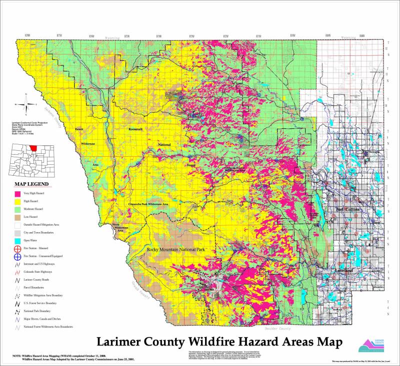
7 of the remaining 40% is unknown, most of these are probably human-caused. It is interesting to note that 1% of the fires account for 90% of the total acres burned (Farmer 1998) Larimer County Wildland Fire Hazard Identification Wildland Fire Hazard Area In 1998, Larimer County identified a wildland fire hazard area that coincided with a roofing ordinance adopted in See Map--Larimer County Wildfire Hazard Area. Generally, this area is from west of Range 69 to the continental divide. Within the Wildland Fire Hazard Area, all new building construction and new land development must meet wildland fire mitigation codes and regulations. These building codes and land use regulations are posted on the wildfire safety program s web site at Wildland Fire Hazard Maps Larimer County, United States Forest Service, National Park Service and Colorado State Forest Service worked together to create a unified, cross-boundary vegetation map for the Wildland Fire Hazard Area. This vegetation map was utilized to determine the wildland fire hazards throughout the County. See Map--Larimer County Wildfire Hazard. Wildland Fire Hazard was determined by combining vegetation cover type, habitat structural stage, percent crown cover, slope and aspect. County Fire Plan 6/16/2006 7
8 Interagency Cooperation Since Larimer County encompasses a mosaic of land ownership and jurisdictional boundaries, interagency cooperation is essential not only for wildland fire suppression but also for prevention, preparedness, mitigation, reclamation / rehabilitation and fiscal issues to provide efficient and effective wildland fire programs. Currently, all fire agencies within Larimer County are working aggressively to provide a consistent and a unified approach to most fire programs regardless of ownership. However, differences do exist between agencies due to internal policies and procedures as well as land base and jurisdictional boundaries. Larimer County Coordinating Group Larimer County Coordinating Group (LCCG) seeks to provide a community-based approach to hazardous fuels management through collaborative processes, using scientific expertise and local knowledge. The overall goal of the partnership is to enhance community sustainability and restore fireadapted ecosystems through identification, prioritization, and implementation of treatment projects in the Front Range of Colorado. In order to achieve the goal of the partnership and facilitate local collaboration, a communitybased coordinating group has been established the Larimer County Coordinating Group. This is an interagency group consisting of but not limited to Larimer County, US Forest Service, Colorado State Forest Service, and Rocky Mountain National Park. The primary role of the coordinating group is to provide leadership and coordination for all fuels management activities in Larimer County. Role of Coordinating Group Ensure the completion and routine maintenance of a comprehensive landscape-level fuels assessment utilizing the best available scientific tools that will evaluate hazards, values, and risks Utilize the fuels assessment findings to prioritize, design, and locate effective fuel treatments in a cohesive strategy; invest in projects that seek to protect communities and watershed values County Fire Plan 6/16/2006 8
9 Coordinate and support Community Wildfire Protection Planning and FireWise efforts with local communities Coordinate and support on-going NEPA efforts by federal agencies; and support work on lands other than federal lands To the greatest extent possible, support on-the-ground efforts by sharing resources and expertise; overcome financial barriers to collaborative efforts Encourage private enterprise participation in treatment implementation Seek financial and political support from federal, state, county, and municipal governments and their leadership Given the proportionally high amount of congressionally designated wilderness and National Park land in the county, work to facilitate the operational feasibility for managing wildland fire for resource benefit, including such benefits as protection of watersheds Provide a communication link with the Front Range Fuels Treatment Partnership Steering Committee and Leadership Team for upward reporting of accomplishments and close coordination of planning and implementation of projects Agency Responsibilities Prevention With the exception of enforcement, wildland fire prevention is a shared responsibility of all agencies. Education and information associated with wildland fire is not jurisdictional and relates to all land ownership. Education and awareness materials are available through all partnering agencies. The USFS and RMNP responsibility for enforcement of wildland fire prevention is tied to primary National Forest lands and National Park land respectively. Larimer County enforces wildland fire prevention on state and private lands. All agencies cooperate to establish restrictions and closures when wildland fire conditions meet pre-established criteria outlined in the Larimer County Annual Operating Plan (AOP). Preparedness County Fire Plan 6/16/2006 9
10 USFS and RMNP responsibility is primarily tied to National Forest lands and National Parks lands respectively. The CSFS and Larimer County assist all agencies, communities and associations with fire planning, readiness and wildland fire hazard identification. All agencies share responsibility to coordinate and cooperate in FireWise planning, Pre-attack planning and communication with the public and the news media. Mitigation USFS and RMNP fuels reduction implementation is tied primarily to National Forest lands and National Park lands. The CSFS has coordinated and assisted on fuel reduction projects on state and private lands. Recent agreements allow for cross-jurisdictional fuel reduction project planning and implementation. Larimer County s wildland fire safety program was established in 1998 to help citizens meet adopted building and land use codes, to provide individual wildland fire hazard site inspections and assessments, to provide slash disposal options and to promote education and awareness of wildland fire and what citizens can do to prepare themselves. Suppression--Wildland Fire Larimer County Sheriff The Larimer County Sheriff is responsible for all wildland fire suppression activities on private and state lands within Larimer County. Initial control actions are normally taken by fire departments, fire protection districts or Larimer County firefighters dispatched by the Larimer County Sheriff's Office (LCSO) Communications Center, or Ft. Collins (FTC) Dispatch Center (Annual Operating Plan (AOP). Colorado State Forest Service The Colorado State Forest Service will, upon request, assist all agencies on wildland fires within Larimer County. The CSFS will assume duties as specified under provisions of the Emergency Fire Fund when a forest fire exceeds the county's resources, upon agreement of the Larimer County Sheriff or designated representative and the State Forester or designated representative (AOP). County Fire Plan 6/16/
11 United States Forest Service The United States Forest Service is responsible for all fire management activities on National Forest lands. Due to the complex intermix of private land within the forest boundary, Larimer County Sheriff s Office (LCSO) Communications Center will notify Ft. Collins Dispatch Center (FTC) per attached dispatch procedures in Section XIV for all forest fires reported within the National Forest or areas of said intermixed ownership (AOP). Bureau of Land Management The Bureau of Land Management is responsible for fire suppression activities on BLM lands. In Larimer County, through cooperative agreement with the BLM, the USFS has initial attack responsibilities for these lands (AOP). Rocky Mountain National Park The National Park Service is responsible for all fire suppression activities on Rocky Mountain National Park lands. RMNP will normally dispatch and make initial attack, or manage wildland fires for resource benefit on fires reported on National Park lands, and will also notify LCSO Communications Center or Fort Collins Dispatch Center of any fires reported to RMNP outside the park boundary (AOP). Reclamation/Rehabilitation The US Forest Service and National Park Service are responsible for burn area emergency rehabilitation (BAER) primarily on affected National Forest lands and National Park lands. Close coordination and cooperation with other agencies is necessary to determine values at risk that may be affected by adjacent land owners. CSFS provides technical assistance to property owners, with support of the Natural Resources Conservation Service. Larimer County coordinates with other county departments, state and federal agencies to assist private landowners affected by wildland fire occurrence. Fiscal Funding for prevention, preparedness, mitigation and burn area rehabilitation by Forest Service personnel is tied to National Forest lands. The Colorado State Forester administers the Emergency Fire Fund (EFF) for those Colorado counties that contribute to the fund. Larimer County contributes annually County Fire Plan 6/16/
12 to this fund. At the Larimer County Sheriff s request, the CSFS District may request EFF designation from the State Forester. If approved, EFF will reimburse county suppression costs according to the current Annual Operating Plan (AOP), the master EFF agreement, and as agreed to for the specific incident. The CSFS will request Federal Emergency Management Agency reimbursement for qualified suppression costs according to the most current agreements. CSFS administers various grants to assist local fire departments and property owners as funds are available for suppression, training and other projects. Community Wildfire Protection Plan Community Wildfire Protection Plans (CWPP) are authorized and defined in Title I of the Healthy Forest restoration Act (HFRA) passed by congress on November 21, 2003 and signed into Law by President Bush on December 3, The Healthy Forest Restoration Act places renewed emphasis on the community planning by extending a variety of benefits to communities with a wildfire protection plan in place. Critical among thee benefits is the option of establishing a localized definition and boundary of the wildland-urban interface and the opportunity to help shape fuels treatment priorities for surrounding federal and non-federal lands. The CWPP, as described in the Act, brings together diverse local interests to discuss their mutual concerns for public safety, community sustainability and natural resources. It offers a positive, solutionorientated environment in which to address challenges such as: local firefighting capability, the needs for defensible space around homes and subdivisions, and where and how to prioritize land management on both federal and non-federal land. The Larimer County Fire Plan may serve as an umbrella plan for smaller communities, until communities identify more site specific detail needed for project specific planning. Therefore communities that are applying for grants, can state that they are in progress of developing a CWPP. Larimer County proactive approach with wildfire mitigation has completed some of the base steps required for a CWPP or the steps are incorporated into other County agreements. The Larimer County Coordinating Group (USFS, CSFS, RMNP, and Larimer County) have developed talking points, a template for communities and accepted the Colorado State Forest Service minimum standards for a CWPP. See below and are available at Talking Points: County Fire Plan 6/16/
13 Is a tool used to engage federal, state, and local partners in building relationships while working toward the common goal of community wildfire protection. Provides the opportunity for the community to identify hazards and values at risk and to develop treatment options on private and public lands within the designated wildland urban interface zone. Enhances the ability to compete for potential funding and receive agency assistance to implement community established priority projects. Originates from the Healthy Forest Restoration Act of 2003 which directs the USDA Forest Service and USDI Bureau of Land Management give specific consideration to the community established priority projects on these federal lands. Tiers directly off of the Larimer County Fire Plan and several other associated documents, to assist communities and ease the completion process. A CWPP when completed is a way to evaluate hazard mitigation progress within the community. County Fire Plan 6/16/
14 Template Community Wildfire Protection Plan [Insert community name] Larimer County, Colorado [Insert date] Introduction This Community Wildfire Protection Plan (CWPP) was developed by [insert community name] with guidance and support from [list agencies and individuals]. This CWPP supplements several Larimer County documents referenced in Appendix A. Information in this plan will be provided at a level of specificity determined by the community and appropriate agencies. The process of developing a CWPP can help a community clarify and refine its priorities for the protection of life, property, and critical infrastructure in the wildland-urban interface. It can also lead community members through valuable discussions regarding management options and implications for the surrounding watershed. Community / / Interested Parties Involved Representatives involved in the development of the [Insert community name] CWPP are included in the following table. Their name, organization, and roles and responsibilities are indicated below: CWPP Development Team Name Organization Roles / Responsibilities [Insert community name] Homeowners Association and/or Community Representatives Primary development of CWPP and decision making community risk and value assessment, development of community protection priorities, and establishment of fuels treatment project [Insert community name] Fire Department Colorado State Forest Service Larimer County Wildfire Safety Program Relevant federal land management agencies (USFS, BLM, etc.) Other organizations designated by the core team (Environmental groups, utilities, recreational groups, etc.) areas and methods Primary development of CWPP and decision making community risk and value assessment, development of community protection priorities, and establishment of fuels treatment project areas and methods Facilitation of planning process and approval of CWPP process and minimum standards. Provides input and expertise on forestry, fire and fuels, and FireWise concepts. Provides input and expertise on hazard assessment, defensible space, and FireWise concepts. Provides input and expertise on federal lands forestry, fire and fuels, and FireWise concepts. Provides input and expertise. This could include community risk and value assessment, development of community protection priorities, and establishment of fuels treatment project areas and County Fire Plan 6/16/
15 methods. Identification of Values at Risk Using technology and local expertise, [insert community name here] has developed a base map and narrative of the community and adjacent landscapes of interest. This map will act as a visual aid from which community members can assess and make recommendations. The base map includes, at a minimum, the following: Inhabited areas and values at potential risk to wildland fire Areas containing critical human infrastructure such as evacuation routes, municipal water supply structures, and major power or communication lines that are at risk from wildfire A preliminary designation of the community s Wildland Urban Interface (WUI) zone. Community Risk Assessment The purpose of the community risk assessment is to help to prioritize areas for treatment and identify the highest priority uses for available financial and human resources. This section is divided into five areas of concern: Fuel Hazards An evaluation of vegetation conditions within the community and on adjacent lands. Products included are: Larimer County Wildfire Safety Program Subdivision Wildfire Hazard Review Larimer County Fuel Hazard Map Risk of Wildfire Occurrence An evaluation of the probability of fire ignition within the community and surrounding lands. Risk to homes, businesses, and essential infrastructure An evaluation of the vulnerability of structures within the community to ignition from firebrands, radiation, and convection. Also includes an evaluation of risks to essential infrastructure such as evacuation routes, water supply structures, and power and communication lines. Products may include: Structure Assessment (construction materials, structure access, defensible space, etc.) Infrastructure Assessment (utilities, water, community roads, power lines, etc.) Risk to Other Community Values An evaluation of risk to other community values such as wildlife habitat, recreation and scenic areas, water supplies, and landscapes of historical, economic or cultural value. Local Preparedness and Firefighting Capability Initial response to all fire, medical and associated emergencies is the responsibility of [insert local fire department name]. Wildland fire responsibilities of Larimer County, Colorado State Forest Service, United States Forest Service, Bureau of Land Management and the National Park Service are described in the current Larimer County Annual Operating Plan. All mutual aid agreements, training, equipment, and response are the responsibility of the local fire department and the agencies listed above. Hazard Reduction Priorities [Attach a prioritized list of community needs regarding fuel reduction treatments within the WUI zone. Fuel reduction needs (Attach map identifying treatment types and ways to reduce structural ignitability.) Fire response needs Action Plan County Fire Plan 6/16/
16 [Insert community name here] has developed and attached an action plan which identifies roles and responsibilities, funding needs and timetables listed in Hazard Reduction Priorities. The core team will meet annually to evaluate progress and mutually agree on treatment priorities. In cooperation with the Larimer County Fire Education Group, the Larimer Fire Council, and the [insert local fire department and other supporters] the [insert community name] supports and promotes Firewise activities as outlined in the Larimer County Fire Plan. [insert community name] supports and educates its citizens in ways to reduce structure ignitibility through meeting Larimer County Building Code Requirements and utilizing Colorado State Forest Service FireWise Construction Fact Sheets. The following community representatives / agencies have reviewed and support this Community Wildfire Protection Plan. [Insert community organization name] [Insert local fire department] Fort Collins District Colorado State Forest Service [Insert other organization or agency] Appendix A Larimer County Fire Plan a Community Wildfire Protection Plan (Larimer County 2004) Larimer County Wildfire Mitigation Plan (CSFS 1998) Recommendations for Improving Wildfire Safety in Larimer County (CSFS 1997) Larimer County Subdivision Wildfire Hazard Review (Larimer County/CSFS 2002) Larimer County Annual Operating Plan (updated annually) FEMA Northern Colorado Natural Hazard Mitigation Plan (2004) County Fire Plan 6/16/
17 Minimum Standards Colorado State Forest Service Minimum Standards for Community Wildfire Protection Plans 1. Participants The core planning team must include local government, local fire authority, local CSFS representative and representatives of relevant federal land management agencies. Planning activities that involve assessing community risks and values, identifying community protection priorities, or establishing fuels treatment project areas and methods MUST involve diverse representation from interested non-governmental stakeholders. 2. Plan Components Community Wildfire Protection Plans must include the following components: o A definition of the community s wildland-urban interface (WUI), preferably outlined on a map with an accompanying narrative. o A discussion of the community s preparedness to respond to wildland fire. o A community risk analysis that considers, at a minimum, fuel hazards, risk of wildfire occurrence and community values to be protected both in the immediate vicinity and the surrounding zone where potential fire spread poses a realistic threat. o Identification of fuels treatment priorities, including locations on the grounds and preferred methods of treatment. o Recommendations regarding ways to reduce structural ignitability. o An implementation plan. 3. Level of Specificity A CWPP may be developed for any level of community, from a homeowner s association or mountain town to a county or metropolitan city. Information contained in the plan should be at a level of specificity appropriate to the size of the community being addressed. For example, data used to develop a community risk analysis or identify fuels treatment priorities for a small town would need to be at a finer scale than that use for a county. County level plans can be used as an umbrella for plans in smaller communities, but should not be considered a substitute. A county plan will not provide the detail needed for project level planning. County Fire Plan 6/16/
18 4. Adapting Existing Plans and Combining Related Plans If a community has an existing plan that already meets the majority of the CWPP criteria, it is preferable to work with the community to adapt that plan to meet the remainder of the criteria. However, plan adaptations must be collaborative as described in (1) above and include stakeholder representation. This is particularly important if the adaptation involves establishing fuels treatment priorities. Communities are encouraged to combine CWPPs with related documents such as FEMA All- Hazard Mitigation Plans where appropriate. Fire Planning Categories A/B/C/D Polygons In developing the Larimer County Fire Plan, the United States Forest Service, Rocky Mountain National Park, Colorado State Forest Service and Larimer County identified fire categories that define the desirability of wildland fire in specific geographic areas with an emphasis on the wildland-urban interface. Each agency-identified-polygon utilized the A/B/C/D classification provided by Colorado State Forest Service Quick Plan. Polygons were drawn with careful consideration for landscape features and conditions that influence fire behavior, threat to values, and difficulty of control. This information was transferred to a geographical information systems map created by Larimer County. See Map--Larimer County Fire Plan Strategies. A-polygons are areas where wildland fire is highly undesirable. Fire has the potential to create great losses and result in high suppression costs. Within the A-polygons, fire suppression and prevention and education actions will be aggressive to keep ignitions to a minimum and restrict fires that do start to a small size. A-polygons are often wildland-urban interface or intermix communities or neighborhoods. Concentrated FireWise and related preparedness education and hazard mitigation efforts will be directed to those areas. County Fire Plan 6/16/
19 B-polygons are areas where wildland fire is undesirable under current conditions. Fuel accumulations have created conditions under which wildland fires are likely to burn with unacceptable intensity and duration. Rapid fire spread may present serious threats to public safety or fire containment. Fire prevention and suppression efforts will be aggressive in these areas. Although under current conditions the potential for catastrophic fire is significant, appropriate fuels management programs may permit restoration of fire-adapted landscapes in which wildland fire is acceptable or desirable. Prescribed fire (and other hazard mitigation) should concentrated in the B-polygons. Over time, B-polygons might be converted to C- polygons. C-polygons are areas where wildland fire is acceptable and often desirable. These are restored fire-adapted landscapes where fire can play a constructive role without creating significant negative side effects. Prescribed fire may be used regularly in C-polygons to maintain fire-adapted conditions and achieve management objectives. Suppression of unplanned fires will be more measured with careful consideration of costs and benefits. Prevention efforts may target certain identified high-risk activities and times of greater risk of ignition. D-polygons are areas where wildland fire is acceptable or desirable and where the potential for damage is insignificant. Prevention and fuels treatment will be relatively uncommon in these areas. Fires that start may be managed to enhance natural resource or ecological values. Suppression will be limited to times where continued burning might pose some special risk to values outside the polygon. Current county policy with regard to state and private lands Currently, on all private lands that fall within any of the A/B/C/D categories, the Larimer County Sheriff s department, with assistance of local fire departments, maintains a full suppression policy. County Fire Plan 6/16/
20 Management of wildland fire suppression efforts is based on life safety, values at risk, tactical planning and resource availability. How does a landowner/manager change categories? Changes can be in any direction. Vegetation can increase or change in ways that control of fire becomes more difficult, or values at risk have increased. The opposite situation is also possible. Examples could include development, in growth of trees or brush, changes of management, identification of unique habitat, reduction of fuel loads. The plan will be reviewed and all factors assessed as needed. Following identification of changes, plan will be adjusted accordingly. Land managers and property owners that desire to change the status of their property prior to planned review / revision, need to document what has changed, impacts on fire control, values at risk, relationship to adjacent polygons. Agency partners will evaluate the request and make changes if appropriate. Wildland Fire Use Agency Roles and Responsibilities Definition: The management of naturally ignited wildland fires to accomplish specific pre-stated resource management objectives in predefined areas outlined in approved land management plans or fire management plans. Operational management is described in the Wildland Fire Implementation Plan (WFIP) for each fire. A Wildland Fire Implementation Plan (WFIP) for wildland fire use-- is required by the United States Forest Service and National Park Service. This plan considers resource benefits and includes: Objectives Factors affecting decision criteria for wildland fire use Preplanned implementation procedures Impacts of implementation Required personnel County Fire Plan 6/16/
21 Critical records (approved plan, monitoring plan, periodic fire assessment, funding codes, fire history, and other records i.e. photo points) Cost Tracking County Fire Plan 6/16/
22 Unites States Forest Service US Forest Service objectives are: to use fire from natural ignitions in a safe, carefully planned, and cost-effective manner to benefit, protect, maintain, and enhance natural resources; to reduce future fire suppression costs; and, to the extent possible, to restore natural ecological processes and achieve management objectives adopted in approved forest land and resource management plans. Wildland fire use refers to the planning and implementation of naturally ignited wildland fires to accomplish specific, pre-stated resource management objectives in predefined geographic areas as defined in the Forest Land and Resource Management Plan and outlined in the Arapaho-Roosevelt National Forest s Fire Management Plan. Rocky Mountain National Park The National Park Service, in accordance with policies established by the Department of the Interior, utilizes the full range of strategic options to manage wildland fire, provided that selected options do not compromise firefighter and public safety, cost effectiveness, benefits, and values to be protected. Suppression of unwanted, potentially environmentally damaging wildland fires is guided by directives provided in the RMNP Fire Management Plan. That plan also outlines the authority to manage naturally ignited wildland fires for resource benefits within areas designated for that management option. Wildland fire use is a desirable method to maintain fire-dependent ecosystems. All wildland fires, regardless of location, that do not meet wildland fire use prescriptive criteria or that are determined to be unwanted wildland fires are defined in the decision criteria checklist will receive a suppression response. Colorado State Forest Service CSFS s role is to assist citizens of Colorado with wildland fire management on private and public lands. CSFS will assist agencies and other government entities with use of naturally-ignited wildland fires to accomplish specific, pre-stated resource management objectives. Costs of projects are determined according to current CSFS policy. Larimer County County Fire Plan 6/16/
23 At this time there is no policy in Larimer County allowing wildland fire use on private lands. Policies are being developed in conjunction with the Colorado State Forest Service. Policy and procedures are currently being developed by Larimer County and the Colorado State Forest Service. A landowners kit is being developed that identifies a step by step process that needs to be followed to conduct a prescribed fire on private land. Update: County Fire Plan 6/16/
24 Prescribed Fire Agency Roles and Responsibilities Definition: Any fire ignited by management actions under certain predetermined conditions to meet specific resource management objectives. A written, approved prescribed fire plan must exist, and agency requirements must be met prior to ignition. United States Forest Service USFS objectives are: to use fire from management ignitions in a safe, carefully planned, and cost effective manner to benefit, protect, maintain, and enhance natural resources resources; to reduce future fire suppression costs; and, to the extent possible, to restore natural ecological processes. Prescribed fire refers to the planning and implementation of management-ignited wildland fires to accomplish specific, pre-stated resource management objectives as defined in the environmental analysis and accomplished through the interdisciplinary team process. At least once a year, district staff meets with local cooperators to discuss future and current fuels projects. Typically, the meetings include the County s fuels hazard mitigation staff and local representatives of the Colorado State Forest Service. Discussions have most often revolved around where to initiate new projects in the urban-wildland intermix. Prior to implementation, the following requirements are fulfilled: Prepare and approve burn plan Obtain smoke permit Prepare communications plan Prepare monitoring plan Provide advance notification to State smoke regulators and (through the Dispatch Center) to area cooperators Provide advance notification to news media, elected officials and neighbors as described in the communications plan Complete a project file including the components required in the burn plan County Fire Plan 6/16/
25 Rocky Mountain National Park The National Park Service is responsible for planning, implementing, and monitoring fuel treatments to protect communities, municipal watersheds, park infrastructure, and resource values from negative impacts of wildland fire. A variety of fuel treatment options are utilized in Rocky Mountain National Park including, but not limited to, thinning, piling, mechanical fuel treatments, and prescribed fire. Colorado State Forest Service CSFS will assist agencies and individuals with the planning and implementation of prescribed fire to accomplish specific resource management objectives. Costs to individuals and agencies of projects are determined according to current CSFS policy. Larimer County Larimer County policy only allows slash pile burning through a permit process in conjunction with the County Health Department. Policies regarding prescribed wildland fire on private lands are being drafted between Colorado State Forest Service and Larimer County. Colorado Department of Public Health and Environment Colorado Department of Public Health and Environment (CDPHE) requires air quality permits for burns conducted by NPS, USFS and CSFS. Other agencies should verify that predicted smoke production of the proposed burn does not require a CDPHE smoke permit. County Fire Plan 6/16/
26 County Fire Plan Detailed Layout The County Fire Plan identifies six management objectives essential to achieve this plan s mission statement. These management objectives include -- Prevention, Preparedness, Mitigation, Suppression, Reclamation / Rehabilitation and Fiscal. For each of the management objectives, contact positions and phone numbers are listed for each agency. Additionally, any agreement that refers to a particular management objective is also listed. A reference appendix will be created that will contain a copy of each agreement. Each management objective lists a statement that summarizes the goal and objective, plus activities that need to be accomplished to meet the objectives and the overall mission statement. For each activity listed, a brief background is provided, along with agencies involved, priority, status, estimated costs, funding sources and completion schedule. Larimer County will serve as the primary agency for all listed activities. Annual Review An interagency group will review the County Fire Plan, management objectives and activities listed to ensure that objectives are being accomplished.. Activities that are listed to be annually or ongoing will be evaluated by March 1. The County Fire Plan will be reviewed on a as needed basis. Activities will likely be added to and removed from the plan due to completion of projects and changes in priorities. The Larimer County Emergency Services/Wildfire Safety will serve as the lead agency and coordinate updates and annual reviews. Future activities can be submitted by any Larimer County resident to the interagency group for review and addition to the year s County Fire Plan. The following format should be utilized for activity submittal. County Fire Plan 6/16/
27 Activity Submittal Form Nominating agency Primary Contact Date Activity Involved Estimated Costs County Fire Plan 6/16/
28 Management Objectives Prevention Agency Contacts: USFS Reduce human caused wildfire ignitions through information, education and enforcement. Canyon Lakes Ranger District Fire Management Officer RMNP Fire Education, Prevention and Information Specialist CSFS Colorado State Forest Service Fort Collins District Larimer County LCES Activity (P1) Estimated Costs Develop a consistent FireWise message for (1) Homeowners (2) Contractors/Developers/Architects and (3) Children Currently, the FireWise message of landowner responsibility is clearly identified for current and future homeowners and landowners. However, the program has expanded and additional messages for developers, contractors and children are needed. Larimer County, CSFS, RMNP, USFS Moderate Ongoing Agency staff time Existing program funds Annual, March 1, 20 COMPLETED Activity (P2) Develop an interagency cadre to present Are You FireWise? presentations To meet the demands for Are You FireWise? educational presentations, a cadre of either volunteer or professional personnel needs to be trained to present wildland fire education and awareness information Larimer County, CSFS, RMNP, USFS Moderate Ongoing County Fire Plan 6/16/
29 Estimated Costs Activity (P3) Estimated Costs Agency Staff Time Existing program funds/grants Annual, March 1, 20 Improve public awareness The individual property owner/occupant has the primary responsibility to protect their property from a wildland fire event. Only limited numbers of citizens in the general public are aware of the wildland fire threat. Information is available, but a coordinated approach to educational and outreach is needed. Larimer County, CSFS, RMNP, USFS High Ongoing Agency Staff time Existing program funds/grants Annual, March 1, 20 Activity (P4) Estimated Costs Develop an on-line catalog that includes an interagency listing of all wildland fire education materials. There is no current list of wildfire education materials available from each agency. Citizens and fire departments should be able to view materials on a web site and order materials if needed. Larimer County, CSFS, RMNP, USFS High Ongoing $1000 to develop web page, $500 annually to deliver products, $1000 annually to purchase and restock materials. Existing program funds/grants Completed, CSFS maintains list. Activity (P5) Develop homeowner/landowner contact database for all agencies Each agency makes contact with landowners, homeowners associations, and communities regarding mitigation issues. We need to keep track of all contacts to develop effective and efficient interagency cross-boundary mitigation projects. County Fire Plan 6/16/
30 Agency Estimated Costs Larimer County, CSFS, RMNP, USFS Low Does not exist yet $2,500 setup costs, $500 annual maintenance Grants December 2007 Activity (P6) Agency Estimated Costs Improve wildfire reporting process private and state lands Provide fire departments an efficient process to report wildfire events. CSFS, RMNP, USFS High Ongoing Agency Staff Time Existing program funds/grants Annual, March 1, 20 Activity (P7) Agency Estimated Costs Develop ways to update news media and Larimer County residents of the current wildfire danger Utilize news media outlets and Public Information personnel officers to inform the citizens of current wildland fire danger. Larimer County, CSFS, RMNP, USFS High Ongoing Agency Staff Time. Staff Time. Existing program funds/grants Annual, March 1, 20 County Fire Plan 6/16/
31 Preparedness Agency Contacts: USFS Plan the most effective level of resources to protect human and natural values. Canyon Lakes Ranger District Fire Management Officer RMNP Fire Management Officer CSFS Colorado State Forest Service Fort Collins District Larimer County Emergency Services Activity (Pr1) Larimer County rural site addressing improvement project The County's current road naming and site addressing system is urgently in need of improvement. Although proper road naming and site addressing is occurring through the land division review and approval process, many very serious deficiencies exist in older platted subdivisions, on metes & bounds parcels, and in 35+ acre developments. Emergency service personnel and parcel delivery companies often are unable to locate properties quickly or at all due to the lack of a road name and site address. Due to inaccurate or inadequate information provided by property owners, many properties have received address numbers that are not accurate, further adding to the confusion. A major barrier to overcoming the many deficiencies of the current system is likely to be resistance by some property owners to naming their road or changing their address. To remedy this situation, Larimer County has hired a consultant to improve site addressing in rural area of the County through a Phase II project Phase I will develop the appropriate solution. Phase II will get all roads named, road signs added, and addresses added or altered accordingly. Phase I began in April 2003 with completion by August Phase I is funded jointly by Larimer County and the Larimer Emergency Telephone Authority (LETA). Phase II is planned for 2004, subject to funding availability. Larimer County Planning and Building Services Division, Larimer County Sheriff s Office, Poudre Fire District, the Larimer Emergency Telephone Authority (LETA) and the County GIS department High Ongoing (Phase 1) Estimated Costs Phase I, $60,000. Possible grant funding sources for Phase II will be identified in Phase I Existing program funds and grants Annual March 1. 20, Larimer County Planning and Building Services Division Lead. County Fire Plan 6/16/
32 Activity (Pr2) Estimated Costs Develop wildland fire hazard education teams In 2000, the Colorado State Forest Service held trainings to develop Wildfire Hazard Education Teams (WHET) to conduct wildland fire hazard mitigation informational meetings for residents, homeowners associations, county officials and other stakeholders who live in outlying areas of a fire incident. The teams will assist and work cooperatively with local agency, county, fire protection districts and fire management team public information officers during and immediately following a wildland fire incident. Larimer County, USFS, RMNP, CSFS High Structure exists but personnel shortage Agency Staff Time Existing program funds and grants Available on request Activity (Pr3) Estimated Costs Assist in the development of evacuation plans Evacuation during a wildland fire event continues to be a problem in the urbanwildland interface. Assisting local fire departments with the development of warning and evacuation systems and protocols will be an overall benefit to the communities at risk. Education of area residents about warning and procedures through mailings, door hangers and public meetings is critical to the success of an evacuation plan. Larimer County, USFS, RMNP, CSFS local fire department participation is critical. High Ongoing County staff time and fire department staff time Existing program funds and grants Available on Request Activity (Pr4) Assist in the development of pre attack plans Assisting local fire department personnel with the development of a pre attack plan for subdivisions or developments within their particular response area is essential in preparing both the emergency response agencies and the residences in the area for a wildland fire event. To build consistency and credibility, it is County Fire Plan 6/16/
33 anticipated that the Colorado State Forest Service pre-attack format will be utilized for all plans. Estimated Costs Activity (Pr5) Estimated Costs Larimer County, USFS, RMNP, CSFS local fire department participation is critical. High Ongoing Agency staff time and fire department staff time Existing program funds and grants Available on request Create complete map books for Larimer County Map or run books of subdivisions and forested areas throughout Larimer County will aid emergency response agencies with locations outside their normal response areas. Larimer County High Complete Agency Staff time Existing program funds and grants Complete Activity (Pr6) Estimated Costs : Develop contact list to disseminate information on current wildland fire danger Visitors and residents need to be aware of daily wildfire danger and where they can obtain more information about fire dangers. Larimer County, CSFS, USFS, RMNP High Ongoing Staff time or contract out Grants Complete County Fire Plan 6/16/
34 Activity (Pr7) Estimated Costs Update the fire department/district response area map The current fire department/district map needs to be updated. Many of the fire departments and districts response areas are expanding due to greater wildland urban-interface development. Larimer County High Ongoing Agency Staff time Grants Annual, March 1, 20 Activity (Pr8) Estimated Costs Georectify aerial photos and establish a maintenance schedule Existing aerial photography of Larimer County has not been incorporated into a County GIS system due to the cost and time required. A maintenance schedule needs to be developed that will update the photography and a regular basis. Need to investigate cost sharing opportunities with other agencies. Larimer County Low Exists only in some areas. Agency Staff time or contract out Grants December 2007 Activity (Pr9) Estimated Costs Prepare data needed for fire behavior forecasts. Place data on CD s by Township-Range-Section (T-R-S) Developing a library of data required to generate fire behavior predictions will allow fire behavior specialists to make better predictions during a wildland fire event. Larimer County, USFS, RMNP, CSFS Low Does not exist Agency Staff time or contract out County Fire Plan 6/16/
35 Grants March 2007 Activity (Pr10) Determine additional fire equipment needs and locations As the wildland-urban interface continues to expand and more structures are built, planning for the additional fire equipment needed and the location of new fire stations is becoming an interagency issue. In the event that the USFS receives a request to locate structures or fire equipment on National Forest land, the USFS will evaluate the proposal based on criteria in the Special Uses Proposal Screening process (initial and secondary levels). Considerations include whether the use can be accommodated on private land, whether the use is compatible with Forest Plan direction, etc. Other agencies may be asked to provide information in order to verify details of the proposal. Estimated Costs Activity (Pr11) Estimated Costs Activity (Pr 12) Larimer County, USFS, RMNP, CSFS, fire departments and districts Moderate Does not exist yet Agency Staff time Existing program funds/grants Complete/ Review as needed Coordination of burn restriction information. Guidelines exist within the annual operating plan for determining the need for fire restriction and/or fire closures. Information as well as implementing or lifting closures/restrictions shall be coordinated with all agencies. Larimer County, CSFS, USFS, RMNP High Ongoing Agency Staff time Existing program funds/grants Annual, March 1, 20 Promote, coordinate and assist in the development of Community Wildfire Protection Plans. Incentive for communities to engage in comprehensive forest planning and prioritization was give new unprecedented impetus with the enactment of the Healthy Forest Restoration Act in A Larimer County Coordinating Group was established to define, coordinated and assisting communities in developing and maintaining a Community Wildfire Protection Plan; talking points and a CWPP addendum has been developed to assist communities through the planning process. County Fire Plan 6/16/
36 Estimated Costs Larimer County, USFS, CSFS and RMNP High On-going Agency Staff Time. Existing program funds/grants Annual, March 1, 20 County Fire Plan 6/16/
37 Mitigation Plan and implement action to reduce potential negative impacts on human and natural values from wildland fire. Agency Contacts: USFS Canyon Lakes Ranger District Planning Team Leader RMNP Fire Management Officer CSFS Colorado State Forest Service Fort Collins District Larimer County LCSO Activity (M1) Estimated Costs Provide listing of current building and land use codes that address wildland fire hazard mitigation Larimer County has taken proactive steps and adopted building codes and land use codes that address wildland fire hazard mitigation and enforcement capabilities. Larimer County High Complete Posted at Agency staff time Staff Time. Existing program funds/grants Complete Activity (M2) Provide citizens with an economical and efficient means of disposal for slash generated during wildland fire mitigation techniques. The Larimer County wildfire safety program has developed a slash disposal program which provides citizens options for disposal. These options include community collections sites, 50/50 cost share, and pile burning Larimer County High Ongoing County Fire Plan 6/16/
38 Estimated Costs $30,000-$50,000 annually Grants Annual, March 1, 20 Activity (M3) Estimated Costs Develop FireWise demonstration sites FireWise demonstration sites have been created on county parks and open lands properties, USFS properties and other private properties. These sites are designed to be highly visible and demonstrate forest management techniques that not only improve forest health conditions but also reduce the impact of a wildland fire event. Larimer County, USFS, RMNP, CSFS High Complete but continually expanding $15,000-$60,000 annually Staff Time. Existing program funds/grants Annual, March 1, 200 Activity (M4) Estimated Costs Conduct required and voluntary wildland fire inspections The Larimer County wildfire safety program currently conducts required wildland fire inspections per the adopted building code and voluntary wildland fire inspections requested by residents. Larimer County, fire departments and CSFS High Ongoing Agency staff time Staff Time. Existing program funds/grants Available on request Activity (M5) Update wildland fire hazard assessment/identification maps Vegetation and the associated wildland fire hazard are constantly changing due to natural growth, mortality, fires and human activities. Larimer County, Colorado State Forest Service and United States Forest Service have developed County Fire Plan 6/16/
39 seamless vegetation and wildland fire hazard maps for Larimer County. These maps constantly change and need to be checked for accuracy and updated. Estimated Costs Larimer County, CSFS, USFS, RMNP High Base map completed updating needed. Agency staff time Existing program funds, grants Completed Activity (M6) Estimated Costs Conduct subdivision/development wildland fire assessments Over 250 subdivisions and developments are located in the wildland-urban interface of Larimer County. Many of these subdivision and developments have been evaluated by the Colorado State Forest Service for wildland fire hazards. A complete and updated list of all current subdivisions and developments is needed. This complete list will identify the most hazardous subdivisions and developments for targeted extensive education and awareness programs. This list will be updated as needed. Larimer County, CSFS, USFS High Ongoing Agency staff time Staff Time. Existing program funds/grants Completed Activity (M7) Identify cross-boundary fuel reduction projects / Front Range Fuels Treatment Partnership Under existing agreements Larimer County, Colorado State Forest Service, Rocky Mountain National Park and the United States Forest Service are working together to identify cross-boundary fuel reduction project within the wildland urban interface. Projects will focus on area where agencies have planned actions to address environment and watershed issues and where residents have expressed interest and support. Larimer County, CSFS, USFS, RMNP High Ongoing County Fire Plan 6/16/
40 Estimated Costs Activity (M8) Estimated Costs Project dependent and agency staff time Existing program funds and grants Available on request Develop FireWise communities The Larimer County wildfire safety program and the Colorado State Forest Service work together to identify and inform communities of the National FireWise Communities recognition program. Larimer County, CSFS High Ongoing Agency staff time, community dependent Existing program funds and grants Annual, March 1, 2005 Activity (M9) Estimated Costs Activity (M10) Develop an accurate media list to disseminate the current wildland fire danger. Accurate news media information is needed to coordinate lifting closures/restrictions and to ensure a cooperative interagency approach and unified presentation to residents. Larimer County, CSFS, USFS, RMNP and fire departments High Ongoing Agency staff time Staff Time. Existing program funds/grants Annual, March 1, 20 COMPLETE Utilize the Alternative Sentencing Unit (ASU) inmates as a labor force to assist with fuels reduction projects on public and private lands. Larimer County Sheriff department proposed utilizing the ASU inmates as a cost effective labor force to assist with fuels reduction projects throughout Larimer County. The Wildfire Safety Program has used ASU on projects in Horsetooth Mountain Park, Glacier View, and magic Ski Girls Scout Ranch with overwhelming success. Future project are currently in the planning process. County Fire Plan 6/16/
41 Cost Estimated Larimer County, USFS, CSFS and RMNP High OnGoing Approximately $15,000 annually Existing Program Funds Annually, March 1, 20 Activity (M11) Cost Estimates Activity (M12) Develop a County-wide contact that coordinates, tracks, schedules and implements fuels reduction efforts on County lands. Fuel reductions forest heath or fire mitigation/demonstration projects are being implemented throughout the County by many different County departments: Wildfire Safety Program, Emergency Services, LC Sheriff ASU, Parks and Open Lands, Horsetooth Mountain Park, Weed District. However, a central coordination point to organize the limited resources and funds in the most effective, manner is needed to ensure effectiveness and avoid duplication of efforts, plus explore large scale funding options. Larimer County High Ongoing Agency staff time Existing Program Funds Annually, March 1, 20 Maintain Fire Mitigation Crews Maintain fire mitigation crew -- utilize Emergency Service Firefighters as a sawyers to implement fire mitigation, forest management projects on County, non-profit, or public lands. Larimer County High Ongoing Estimated Costs $25,000-$125,000 Agency staff time grants County Fire Plan 6/16/
42 Annually, March 1, 20 County Fire Plan 6/16/
43 Suppression Agency Contacts: USFS Use appropriate strategies and tactics for safe and cost effective protection of human and natural resource values from wildland fire. Canyon Lakes Ranger District Fire Management Officer RMNP Fire Management Officer CSFS Colorado State Forest Service Fort Collins District Larimer County Emergency Services Activity (S1) Estimated Costs Larimer County resource list Maintaining a current list of equipment and personnel available for response to wildland fire events in Larimer County is essential for resource coordination. Lists should contain dept./agency contact information, equipment type, National Wildfire Coordinating Group qualified personnel and qualification level. Larimer County, USFS, CSFS, RMNP High Exists in various formats Agency Staff time Existing program funds Annual, March 1, 20 Activity (S2) Implementation of FMAZ (Fire Management Action Zones) planning levels Update and disseminate to all responding agencies current FMAZ zones to enhance interagency initial attack. Current FMAZ structure outlines initial resources dispatch in the county by type and number based on area and current fire conditions. USFS, RMNP Larimer County High Ongoing County Fire Plan 6/16/
44 Estimated cost Agency Staff time Existing program funds Annual, March 1, 20 Activity (S3) Back ground Estimated cost Identify and establish county wide map for A/B/C/D polygons The identification and designation of areas in Larimer County based on the A/B/C/D polygon definitions will be instrumental in orienting where mitigation, prevention, pre-planning and suppression projects and activities should be coordinated. The mapping will also serve to assist with cross boundary projects coordinated with state and federal land management agencies. Larimer County, USFS, RMNP and CSFS High Complete Agency staff time Existing Program Funds Complete Activity (S4) Estimated Cost Larimer County Annual Operating Plan (AOP) The Larimer County AOP defines the current suppression relationship and fire business management practices between local, county, state and federal wildland fire suppression resources in Larimer County. This document is reviewed and signed by the Larimer County Commissioners, LCSO, USFS, CSFS, RMNP and BLM annually. LCSO, USFS, RMNP, CSFS, BLM and Board of County Commissioners High Complete Existing program Agency Program budgets Annual, March 1, 20 County Fire Plan 6/16/
45 Activity (S5) Estimated Costs Mutual aid agreements Rapid mobilization of resources after initial reports of wildland fire is critical in keeping fires small and reducing the risk to lives and property. To insure maximum resource response, mutual aid agreements are maintained between the LCSO and each Fire Protection District and Volunteer Fire Dept. in Larimer County. These agreements allow each agency to tap closest resources to assist them on wildland fires without consideration for reimbursement for costs for the first 12 hours on the incident. LCSO, fire departments and volunteer fire departments in Larimer County High Complete- needs updating Agency staff time Agency budgets January, annually Activity (S6) Estimated cost Coordinated communications Currently different radio systems are in use throughout Larimer County. There are additional changes on the horizon with VHF and 800 mg Hz. systems that will have an impact countywide. For agencies to maintain functional communications with each other and to assist in budgetary planning for future system purchases, there needs to be a coordinated effort through existing fire service associations to keep up to date. The Northern Colorado Front Range Wildfire Cooperators Group (NCFRWCG) and Larimer Fire Council (LFC) are currently trying to keep everyone up to date and coordinate issues as they arise. Larimer County, LCSO, USFS, CSFS, RMNP High Coordination needed Agency staff time Existing program budgets meeting July/August NCFRWCG, LFC County Fire Plan 6/16/
46 Reclamation/Rehabilitation Agency Contacts: Assess impact of wildland fire on human and natural values. Identify the roles and responsibilities of appropriate agencies and funding sources. USFS Arapaho Roosevelt National Forest Staff Hydrologist RMNP Fire Effects Specialist CSFS Colorado State Forest Service Fort Collins District Larimer County Emergency Management Activity (R1) Estimated Costs Infra-structure assessment and Agency Contact During and after wildland fire incidents, there will often be impacts on the infrastructure in burn areas. These impacts may require a variety of county, State or Federal agencies to mitigate the impact and assure quality of life for the citizens of Larimer County. Additional funding sources may need to be identified and applied that could impact service providers. To prepare for these situations, a list of possible fire impacts on the infrastructure and what agency/department would be involved in assessment and mitigation will be coordinated through the Larimer County Emergency Manager. Larimer County Emergency Manager, Larimer County Manager, USFS, RMNP Moderate To be done Current staff time Agency program budgets Annual, March 1, 20 County Fire Plan 6/16/
47 Fiscal Establish funding priorities and budget strategies for management objectives. Agency Contacts: USFS Arapaho Roosevelt National Forest Fire Management Officer RMNP Fire Management Officer CSFS Colorado State Forest Service Fort Collins District Larimer County Emergency Services Activity (F1) Estimated Costs Identify, prioritize and develop cost estimates. Cooperators will identify, prioritize and develop cost estimates for common management objectives. Cooperators will be identified that can contribute an amount. Other cooperators will then be able to submit future budget requests. This process will be reviewed on an annual basis. Larimer County, USFS, RMNP, CSFS Moderate Does not exist Current staff time Agency Program Funds Annual, March 1, 20 County Fire Plan 6/16/
48 Maps Larimer County Location County Fire Plan 6/16/
49 Larimer County Land County Fire Plan 6/16/
50
51 Larimer County Residential Improvement County Fire Plan 6/16/
52 Larimer County Fire Protection Districts County Fire Plan 6/16/

53
54 Larimer County Wildfire Hazard Area County Fire Plan 6/16/
55
56 Larimer County Wildfire Hazard County Fire Plan 6/16/

57
58 Larimer County Fire Plan Strategies County Fire Plan 6/16/

59
Community Wildfire Protection Plan. Big Elk Meadows Larimer County, Colorado 7/3/2007
 Community Wildfire Protection Plan Big Elk Meadows Larimer County, Colorado 7/3/2007 Introduction This Community Wildfire Protection Plan (CWPP) was developed by Big Elk Meadows with guidance and support
Community Wildfire Protection Plan Red Feather Lakes Larimer County, Colorado. February 1, 2006 UPDATED April 26, 2007
 Community Wildfire Protection Plan Red Feather Lakes Larimer County, Colorado February 1, 2006 UPDATED April 26, 2007 Introduction This Community Wildfire Protection Plan (CWPP) was developed by Red Feather
Executive Summary. San Marcos Pass - Eastern Goleta Valley Mountainous Communities Community Wildfire Protection Plan
 Executive Summary San Marcos Pass - Eastern Goleta Valley Mountainous Communities Community Wildfire Protection Plan The San Marcos Pass and Eastern Goleta Valley (SMP/EGV) Mountainous Communities Community
Preparing a Community Wildfire Protection Plan
 Preparing a Community Wildfire Protection Plan A Handbook for Wildland Urban Interface Communities Sponsored By: Communities Committee National Association of Counties National Association of State Foresters
2017 REQUEST FOR APPLICATIONS Forest Restoration and Wildfire Risk Mitigation Grant Program
 Background REQUEST FOR APPLICATIONS Forest Restoration and Wildfire Risk Mitigation Grant Program Established by SB 17-050 During the legislative session the Colorado General Assembly passed Senate Bill
A Community Wildfire Protection Plan. Insert signature Block
 A Community Wildfire Protection Plan Insert signature Block A Community Wildfire Protection Plan A Simplified Template Objectives of a Community Wildfire Protection Plan: Comprehensive Forest planning
Community Wildfire Protection Plan Development Process for Santa Barbara County
 Community Wildfire Protection Plan Development Process for Santa Barbara County The purpose of a Community Wildfire Protection Plan (CWPP) is to identify and prioritize areas for hazardous fuel reduction
NDSU - North Dakota Forest Service North Dakota Cooperative Fire Protection Initiative Budget Request
 Agency Information NDSU - North Dakota Forest Service North Dakota Cooperative Fire Protection Initiative 2015-17 Budget Request North Dakota State Board of Higher Education May 29, 2014 NDSU-North Dakota
OBSTACLES AND SOLUTIONS
 OBSTACLES AND SOLUTIONS The Douglas County CWPP Core Team identified six common obstacles that communities and stakeholders throughout Douglas County face in working to become safer from wildfire. These
Fire Adapted Communities on the Plains. Master Volunteer Forest Steward Course Lisa Mason, Colorado State Forest Service April 22, 2014
 Fire Adapted Communities on the Plains Master Volunteer Forest Steward Course Lisa Mason, Colorado State Forest Service April 22, 2014 About the CSFS The mission of the CSFS is to achieve stewardship of
ANNEX M: HAMILTON CREEK METROPOLITAN DISTRICT
 ANNEX M: HAMILTON CREEK METROPOLITAN DISTRICT M.1 Community Profile (HCMD) is a special district in Summit County. The District operates under the direction of a five person, elected Board of Directors.
Linn County Community Wildfire Protection Plan
 Linn County Community Wildfire Protection Plan Prepared for Linn County by ECONorthwest 99 W. Tenth, Suite 400 Eugene, OR 97401 541.687.0051 November 2007 Prepared for Washington County by Written by:
State and Private Forestry Fact Sheet. Investment in State's Cooperative Programs:
 State and Private Forestry Fact Sheet 2015 Idaho Investment in State's Cooperative Programs: Program FY 2014 Final Community Forestry and Open Space $0 Cooperative Lands - Forest Health Management $364,500
APPENDIX 5: PIONEER/VOLCANO PLAN- NING UNIT COMMUNITY FEATURES
 APPENDIX 5: PIONEER/VOLCANO PLAN- NING UNIT COMMUNITY FEATURES CONTENTS Pioneer/Volcano Community Features... 102 5.1. Social and Political Setting... 102 5.1.1. Cultural Resources... 102 5.1.2. Population
Position Paper on the Nevada County Fire Plan
 228 Commercial Street #277, Nevada City, CA 95959 http://www.fona-nevco.org Position Paper on the Nevada County Fire Plan Presented by the Federation of Neighborhood Associations Revised April 2006 Summary
Section 1 Introduction
 Section 1 Introduction Plan Purpose The Lane County Community Wildfire Protection Plan (CWPP) identifies strategies and priorities for the protection of life, property, and infrastructure in the wildland-urban
Fire Adapted Communities. Wildfire Watershed Protection Group Courtney Peterson Colorado State Forest Service November 18, 2016
 Fire Adapted Communities Wildfire Watershed Protection Group Courtney Peterson Colorado State Forest Service November 18, 2016 The Colorado State Forest Service The mission of the CSFS is to achieve stewardship
RIM FIRE Preliminary Fuel Treatment Effectiveness Report
 RIM FIRE Preliminary Fuel Treatment Effectiveness Report USDA Forest Service, Pacific Southwest Region, Stanislaus National Forest DOI National Park Service, Pacific West Region, Yosemite National Park
CRS Report for Congress
 CRS Report for Congress Received through the CRS Web Order Code RS22024 January 14, 2005 Wildfire Protection in the 108 th Congress Summary Ross W. Gorte Specialist in Natural Resources Policy Resources,
PRESCRIBED FIRE IN SOUTHWEST IDAHO
 2016 PRESCRIBED FIRE IN SOUTHWEST IDAHO In southwest Idaho, public land managers work to: address public health and safety concerns; treat insect and disease infestations; reduce the risk of severe wildfires
Characterizing the Fire Threat to Wildland Urban Interface Areas in California
 Introduction Characterizing the Fire Threat to Wildland Urban Interface Areas in California This document outlines the procedures used to identify areas in California that pose significant threats from
DOUGLAS COUNTY ZONING RESOLUTION Section 17 Wildfire Hazard - Overlay District 3/10/99. -Section Contents-
 SECTION 17 WILDFIRE HAZARD - OVERLAY DISTRICT -Section Contents- 1701 Intent... 17-2 1702 Definitions... 17-2 1703 Applicability... 17-5 1704 Wildfire Hazard Overlay District Map... 17-6 1705 Wildfire
MEMORANDUM. Governor John Hickenlooper & Members of the Colorado General Assembly
 690 Kipling Street, Suite 3000 Lakewood, CO 80215 MEMORANDUM TO: FROM: Governor John Hickenlooper & Members of the Colorado General Assembly Paul L. Cooke, Director (Outgoing) DATE: April 25, 2016 RE:
Statement for the Record. Forest Service. United States Department of Agriculture. For the United States House of Representatives
 Statement for the Record Forest Service United States Department of Agriculture For the United States House of Representatives Committee on Natural Resources Subcommittee on Public Lands and Environmental
Appendix C Risk Assessment Methods
 Appendix C Risk Assessment Methods The following section outlines the specific methods, data, and values used to evaluate wildfire risk in Lane County. Identifying the Wildland Urban Interface Risk The
Draft Updated Navajo and Apache County - Sitgreaves Communities Wildfire Protection Plan
 Draft Updated Navajo and Apache County - Sitgreaves Communities Wildfire Protection Plan Apache County Navajo County City of Show Low Town of Pinetop-Lakeside Clay Springs-Pinedale Fire Department Heber-Overgaard
A publication of the National Wildfire Coordinating Group. Wildland Urban Interface Wildfire Mitigation Desk Reference Guide
 A publication of the National Wildfire Coordinating Group PMS 051 Wildland Urban Interface Wildfire Mitigation Desk Reference Guide August 2014 August 2014 Wildland Urban Interface Wildfire Mitigation
A publication of the National Wildfire Coordinating Group. Wildland Urban Interface Wildfire Mitigation Desk Reference Guide
 A publication of the National Wildfire Coordinating Group PMS 051 Wildland Urban Interface Wildfire Mitigation Desk Reference Guide August 2014 Wildland Urban Interface Wildfire Mitigation Desk Reference
Southern Interagency. Wildland-Urban Interface Strategy. A five to ten year wildland-urban Interface Strategy for the South.
 Southern Interagency Wildland-Urban Interface Strategy June 1 2010 A five to ten year wildland-urban Interface Strategy for the South. Interagency Wildland-Urban Interface Fire Strategy Southern Area Executive
Walton Lake Restoration Project
 Walton Lake Restoration Project Fire and Fuels Specialist Report, February 2017 Ochoco National Forest Lookout Mtn. Ranger District Barry Kleckler Fuels Specialist, Prairie Division, Central Oregon Fire
Managing Fire Risk in the Bowen Island Municipality. April By 2007 B.A. Blackwell & Associates Ltd.
 Managing Fire Risk in the Bowen Island Municipality April By 2007 B.A. Blackwell & Associates Ltd. PURPOSE OF THE PLAN To identify interface wildfire risks and develop steps needed to reduce those risks
Applegate Adaptive Management Area. Rogue River-Siskiyou National Forest
 Applegate Adaptive Management Area Rogue River-Siskiyou National Forest Josephine County Applegate Watershed Fun Facts 493,000 Acres (770 sq. miles) 262,400 Acres in Jackson County 172,800 Acres in Josephine
Regulating the Wildland Urban Interface
 Regulating the Wildland Urban Interface How Municipalities can Help Curb the Megafire Epidemic RMLUI Land Use Conference March 1, 2012 Denver, CO Colorado Wildfire Background Last two major fires in Colorado
Silver City Case Study (text only) Community Responses to Wildland Fire Threats in New Mexico
 Community Responses to Wildland Fire Threats in New Mexico") Overview Silver City, located in Grant County, lies in southwestern New Mexico at the base of the Pinos Altos Mountains. The city borders the southern edge of Gila National Forest and is a short distance
Overview Silver City, located in Grant County, lies in southwestern New Mexico at the base of the Pinos Altos Mountains. The city borders the southern edge of Gila National Forest and is a short distance
Cross Boundary work is Key Collaborative restoration treatments across ownership boundaries are critical in creating fire adapted communities
 Millis Swamp Fire Croatan NF Cross Boundary work is Key Collaborative restoration treatments across ownership boundaries are critical in creating fire adapted communities Introduction While implementing
Land Use Planning to Reduce Wildfire Risk: Lessons from Five Western Cities
 Land Use Planning to Reduce Wildfire Risk: Lessons from Five Western Cities Land Use Planning Strategies to Reduce Wildfire Risk Community Initiatives Voluntary Property Assessment Partnerships and Coalitions
Sitgreaves Communities Wildfire Protection Plan
 Sitgreaves Communities Wildfire Protection Plan Update Prepared for: Navajo County, Coconino County, City of Show Low, Town of Pinetop-Lakeside Sitgreaves Communities Wildfire Protection Plan Update Sitgreaves
FOREST SERVICE MANUAL NATIONAL HEADQUARTERS (WO) WASHINGTON, DC
 WASHINGTON, DC") DRAFT Page 1 of 19 FOREST SERVICE MANUAL NATIONAL HEADQUARTERS (WO) WASHINGTON, DC 1 2 3 4 5 6 7 8 9 10 11 12 13 14 15 16 17 18 19 20 21 22 23 24 25 26 27 28 29 30 31 FSM 5100 WILDLAND FIRE MANAGEMENT
DRAFT Page 1 of 19 FOREST SERVICE MANUAL NATIONAL HEADQUARTERS (WO) WASHINGTON, DC 1 2 3 4 5 6 7 8 9 10 11 12 13 14 15 16 17 18 19 20 21 22 23 24 25 26 27 28 29 30 31 FSM 5100 WILDLAND FIRE MANAGEMENT
Forest Restoration and Fire Prevention in the Lake Tahoe Basin
 Forest Restoration and Fire Prevention in the Lake Tahoe Basin Legislative Committee for the Review and Oversight of the Tahoe Regional Planning Agency (TRPA) and the Marlette Lake Water System January
US Forest Service Open Space Conservation Strategy
 US Forest Service Open Space Conservation Strategy Transportation Research Board September 3, 2008 Atlanta, Georgia Photo Credit: Regents at the University of Minnesota. All rights reserved. Used with
FLORIDA S FOREST ACTION PLAN NATIONAL PRIORITIES. 1. Conserve and Manage Working Forest Landscapes for Multiple Values and Uses
 NATIONAL PRIORITIES SECTION Update Report STATE OF FLORIDA 2015 The 2008 Farm Bill, under Title VIII Forestry, amends the Cooperative Forestry Assistance Act of 1978, to include the requirement that each
REQUEST FOR PROPOSAL Maggie Creek Fire Response Guide
 CLEARWATER RESOURCE CONSERVATION AND DEVELOPMENT COUNCIL, INC. PO BOX 9576 MOSCOW, ID 83843 CLEARWATERRCD.ORG (208) 883-4471 REQUEST FOR PROPOSAL Deadline: 9:00 a.m. PST January 8, 2018 INTRODUCTION The
Resources for Private Forest Landowners in New Mexico
 Resources for Private Forest Landowners in New Mexico Staff from the Natural Resources Conservation Service, New Mexico State Forestry and the South Central Mountain Resource Conservation & Development
Western Governors Association Policy Resolution Wildland Fire Management and Resilient Landscapes A. BACKGROUND
 Western Governors Association Policy Resolution 2016-06 Wildland Fire Management and Resilient Landscapes A. BACKGROUND 1. The health of the nation s federal forests and rangelands has deteriorated due
State and Private Forestry Fact Sheet
 State and Private Forestry Fact Sheet New Mexico 2017 Investment in State's Cooperative Programs Program FY 2016 Final Community Forestry and Open Space $0 Cooperative Lands - Forest Health Management
The National Fire Plan: Managing the Impacts of Wildfires on Communities and the Environment. An Overview and Look Ahead
 The National Fire Plan: Managing the Impacts of Wildfires on Communities and the Environment An Overview and Look Ahead April 23, 2002 Background: In September 2000, the Departments of Agriculture and
Boulder Ranger District
 United States Department of Agriculture Forest Service Boulder Ranger District 2140 Yarmouth Avenue Boulder, CO 80301-1615 Voice: (303) 541-2500 Web: www.fs.usda.gov/arp Fax: (303) 541-2515 File Code:
Sustainable Forestry Initiative
 Sustainable Forestry Initiative Mike Lester, Colorado State Forest Service October 16, 2018 The Colorado State Forest Service: Managing Forests Statewide Active management of Colorado s diverse forest
MEMORANDUM OF UNDERSTANDING BETWEEN U.S. DEPARTMENT OF AGRICULTURE FOREST SERVICE
 MEMORANDUM OF UNDERSTANDING BETWEEN U.S. DEPARTMENT OF AGRICULTURE FOREST SERVICE U.S. DEPARTMENT OF AGRICULTURE NATURAL RESOURCES CONSERVATION SERVICE WASHINGTON STATE CONSERVATION COMMISSION WASHINGTON
Prepared By: Final Report for Pigeon Forge, Tennessee October 2018
 Prepared By: Final Report for Pigeon Forge, Tennessee October 2018 About the Community Planning Assistance for Wildfire Program The Community Planning Assistance for Wildfire (CPAW) program works with
2.1 NEIGHBORHOOD BOUNDARY DELINEATION
 2.0 METHODOLOGY 2.1 NEIGHBORHOOD BOUNDARY DELINEATION The wildland-urban interface is the place where homes and wildland meet. This project focused on identifying hazards and risks in the wildland-urban
Humboldt County Community Wildfire Protection Plan 2013 UPDATE
 Humboldt County Community Wildfire Protection Plan 2013 UPDATE Humboldt County Fire Safe Council A committee appointed by your Board to oversee the maintenance and implementation of the County s fire plan
Multnomah County CWPP See
 A-3. Community at Risk: Portland Fire & Rescue The City of Portland and the area covered by the Portland have been identified as a Community at Risk (CAR) by the Oregon Department of Forestry. Portland
State Forest Action Plans: Protecting, Enhancing and Conserving State and Private Forests
 State Forest Action Plans: Protecting, Enhancing and Conserving State and Private Forests Joint Forestry Team USDA Forest Service (USFS) Natural Resource Conservation Service (NRCS) National Association
October Effective Wildfire Mitigation in the Wildland-Urban Interface: A Research Summary
 October 2015 Effective Wildfire Mitigation in the Wildland-Urban Interface: A Research Summary 4 THE WILDFIRE THREAT 2013 Jaroso Fire via InciWeb (above) Wildfire threatens people and homes across the
COMMUNITY WILDFIRE PROTECTION PLAN (CWPP) GLEN HAVEN/RETREAT COMMUNITIES LARIMER COUNTY, COLORADO
 GLEN HAVEN/RETREAT COMMUNITIES LARIMER COUNTY, COLORADO") COMMUNITY WILDFIRE PROTECTION PLAN (CWPP) GLEN HAVEN/RETREAT COMMUNITIES LARIMER COUNTY, COLORADO DEVELOPED BY: GLEN HAVEN AREA VOLUNTEER FIRE DEPARTMENT, INC. STEVEN D. CHILDS, CHIEF JASON GDOVICAK, CAPTAIN
COMMUNITY WILDFIRE PROTECTION PLAN (CWPP) GLEN HAVEN/RETREAT COMMUNITIES LARIMER COUNTY, COLORADO DEVELOPED BY: GLEN HAVEN AREA VOLUNTEER FIRE DEPARTMENT, INC. STEVEN D. CHILDS, CHIEF JASON GDOVICAK, CAPTAIN
Wildland Fire Management Strategy
 Wildland Fire Management Strategy Draft 2014 Executive Summary The Wildland Fire Management Strategy provides strategic direction for MNRF s management of wildland fire within the province of Ontario.
NEWAYGO COUNTY Community Wildfire Protection Plan 2010 Edition
 NEWAYGO COUNTY Community Wildfire Protection Plan November 8, 2010 The purpose of the is to protect human life and reduce property loss due to catastrophic wildland fire in Newaygo County. The Community
Frequently Asked Questions about the Cohesive Strategy and the. Northeast Regional Action Plan
 Frequently Asked Questions about the Cohesive Strategy and the Northeast Regional Action Plan What is the Cohesive Strategy? The National Cohesive Wildland Fire Management Strategy (Cohesive Strategy)
2002 SUMMARY REPORT Oregon Department of Forestry Tribal/State Agency Government-to-Government Relations
 2002 SUMMARY REPORT KEY CONTACT: Roy Woo, Deputy State Forester 2600 State Street, Salem Oregon 97310 503-945-7202 fax 503-945-7212 e-mail: rwoo@odf.state.or.us INTRODUCTION During 2002, the (ODF) has
Bastrop County, Texas Wildfire Mitigation Study
 SREF-CFS-002 Bastrop County, Texas Wildfire Mitigation Study The National Cohesive Wildland Fire Management Strategy is a national collaborative effort to bring a broad cross-section of stakeholders together
Bureau of Land Management Fire Management Plan Interim Guidance
 Bureau of Land Management Fire Management Plan Interim Guidance The Interagency Fire Management Plan template was signed on May 14, 2002, by all Federal Wildland Fire Agency Directors. It directs offices
Sitgreaves Communities Wildfire Protection Plan
 Sitgreaves Communities Wildfire Protection Plan Update 2009 Prepared for: Navajo County, Coconino County, City of Show Low, Town of Pinetop-Lakeside Sitgreaves Communities Wildfire Protection Plan Update
Alberta s FireSmart Program Gavin Hojka Wildfire Management Branch Alberta Agriculture and Forestry
 Alberta s FireSmart Program 2017 Gavin Hojka Wildfire Management Branch Alberta Agriculture and Forestry Contents Wildfires in Alberta Introduction to FireSmart in Alberta The Scales of FireSmart Introduction
Cherry Prescribed Fire After Action Review
 Cherry Prescribed Fire After Action Review Prescott National Forest Verde Ranger District Camp Verde, Arizona June 30 July 2, 2003 EXECUTIVE SUMMARY The Cherry Prescribed Fire on the Verde Ranger District,
Issues, Challenges and Opportunities at the Wildland- Urban Interface
 Issues, Challenges and Opportunities at the Wildland- Urban Interface Annie Hermansen USDA Forest Service, Southern Research Station Eliana Kämpf Binelli School of Forest Resources and Conservation, University
MODULE 5: ECOLOGICAL IMPACTS
 MODULE 5: ECOLOGICAL IMPACTS Purpose This module describes measures for ecological restoration and rehabilitation efforts. The module is primarily focused on fire hazard reduction and its ecological effects.
B. Wildfire Mitigation
 B. Wildfire Mitigation Addendum Part B supplements the information in Parts I through VIII of the HMA Unified Guidance. Addendum Part B is applicable to HMGP and the PDM Program and supersedes FEMA Mitigation
THE FRONT RANGE FUELS TREATMENT PARTNERSHIP 2012 ANNUAL REPORT INTRODUCTION
 THE FRONT RANGE FUELS TREATMENT PARTNERSHIP COLORADO STATE FOREST SERVICE NATIONAL PARK SERVICE USDA FOREST SERVICE 2012 ANNUAL REPORT I n 2012, Front Range Fuels Treatment Partnership (FRFTP) agencies
El Dorado County COMMUNITY WILDFIRE PROTECTION PLAN Community Tab for ROYAL EQUESTRIAN ESTATES FIRE SAFE COUNCIL ACTIVITIES
 El Dorado County COMMUNITY WILDFIRE PROTECTION PLAN Community Tab for ROYAL EQUESTRIAN ESTATES FIRE SAFE COUNCIL ACTIVITIES Prepared for Inclusion in the: EL DORADO COUNTY FIRE SAFE COUNCIL Community Wildfire
COMMUNITY GUIDE to Preparing and Implementing a Community Wildfire Protection Plan AUGUST 2008
 COMMUNITY GUIDE to Preparing and Implementing a Community Wildfire Protection Plan AUGUST 2008 A supplemental resource guide to Preparing a Community Wildfire Protection Plan:A Handbook for Wildland-Urban
Running head: DEVELOPMENT OF A WILDLAND URBAN INTERFACE PROGRAM
 Wildland Urban Interface Plan 1 Running head: DEVELOPMENT OF A WILDLAND URBAN INTERFACE PROGRAM Development of a Wildland Urban Interface Mitigation Program for the Rapid City Fire Department Mike Maltaverne
WILDLAND FIRE MANAGEMENT PROGRAM for Use with DOE 450.1, Environmental Protection Program
 NOT MEASUREMENT SENSITIVE DOE G 450-1.4 O2-11-04 IMPLEMENTATION GUIDE WILDLAND FIRE MANAGEMENT PROGRAM for Use with DOE 450.1, Environmental Protection Program [This Guide describes suggested nonmandatory
Firewise Communities:
 Firewise Communities: Where We Live. How We Live. An introduction to Firewise concepts for local communities Agenda National Firewise Communities Program Understanding Wildfire How Homes Ignite Hazard
Community Wildfire Hazard Risk Assessment Sun Country Cle Elum, WA
 Community Wildfire Hazard Risk Assessment Cle Elum, WA Prepared by Suzanne Wade, FIREWISE Coordinator Kittitas County Conservation District Firewise Communities/USA Recognition Program Page 1 of 12 Table
COLORADO STATE FOREST SERVICE. Orientation for Master Volunteer Forest Steward
 COLORADO STATE FOREST SERVICE Orientation for Master Volunteer Forest Steward Outreach Division Conservation Education Public & Media Relations Policy & Legislative Affairs Volunteer Program Extension
State and Private Forestry Programs
 Appropriation State and Private Forestry The Fiscal Year (FY) 2009 President s Budget proposes $109,500,000 for programs under the State and Private Forestry appropriation, a decrease in budget authority
April 27, Dear Chairwoman Murkowski and Ranking Member Udall:
 April 27, 2018 The Honorable Lisa Murkowski Chair, Appropriations Subcommittee on Interior, Environment and Related Agencies U.S. Senate Washington, D.C. 20510 The Honorable Tom Udall Ranking Member, Appropriations
APPENDIX D: WILDFIRE ASSESSMENT
 APPENDIX D: WILDFIRE ASSESSMENT Community Wildfire Hazard Assessment Report Montgomery County, Kansas Jason Hartman, Fire Prevention Specialist Kansas Forest Service June 20, 2008 Objective To provide
Rocky Mountain Fire Community Wildfire Protection Plan Executive Summary
 Rocky Mountain Fire Community Wildfire Protection Plan Executive Summary The Rocky Mountain Fire Community Wildfire Protection Plan (RMF- CWPP) is a multiyear guiding document that will facilitate the
Full Document, go to:
 Full Document, go to: http://idahocounty.org/fire-mitigation/ Idaho County, Idaho, Revised Wildland-Urban Interface Wildfire Mitigation Plan Reviised Octtoberr 6,, 2009 Vollume II off IIII Vision: Institutionalize
DECISION MEMO MANHATTAN FUELS REDUCTION PROJECT U.S. FOREST SERVICE CANYON LAKES RANGER DISTRICT LARIMER COUNTY, CO
 DECISION MEMO MANHATTAN FUELS REDUCTION PROJECT U.S. FOREST SERVICE CANYON LAKES RANGER DISTRICT LARIMER COUNTY, CO Background and Project Description In order to improve forest health and reduce hazardous
USDA defers to the Department of the Interior regarding the impact of the legislation on the Department s programs and authorities.
 Statement of Leslie Weldon Deputy Chief, National Forest System Forest Service United States Department of Agriculture Before the United States Senate Committee on Energy and Natural Resources Subcommittee
JUNE 20, Collaborative Initiatives: Restoring watersheds and large landscapes across boundaries through State and Federal partnerships
 TESTIMONY of LESLIE WELDON DEPUTY CHIEF, NATIONAL FOREST SYSTEM UNITED STATES DEPARTMENT OF AGRICULTURE FOREST SERVICE BEFORE THE SENATE COMMITTEE ON ENERGY AND NATURAL RESOURCES SUBCOMMITTEE ON PUBLIC
land more than 20 years ago and continues to expand these efforts.
 3 ecological health INTRODUCTION More than 100,000 acres of open space have been protected by Boulder County to preserve natural, cultural, and agricultural resources and provide public uses that reflect
A COMMUNITY WILDFIRE PROTECTION PLAN
 A COMMUNITY WILDFIRE PROTECTION PLAN DEVELOPED BY THE LAKE ALMANOR COUNTRY CLUB FIREWISE COMMITTEE WITH SUPPORT FROM THE PLUMAS COUNTY FIRE SAFE COUNCIL AND THE PLUMAS COUNTY OFFICE OF EMERGENCY SERVICES
Dear Interested Party;
 United States Department of Agriculture Forest Service Caribou-Targhee National Forest Curlew National Grassland Westside Ranger District 4350 Cliffs Drive Pocatello, ID 83204 (208) 236-7500 File Code:
Wildfire Hazard Mitigation Plan
 State of Colorado Wildfire Hazard Mitigation Plan Colorado Multi-Hazards Mitigation Plan July 2002 Update For Fires in Calendar Years 2000 and 2001 Preface This 2001 Plan recognizes the validity and importance
MAY 17,
 STATEMENT OF LESLIE WELDON DEPUTY CHIEF, NATIONAL FOREST SYSTEM U.S. FOREST SERVICE U.S. DEPARTMENT OF AGRICULTURE BEFORE THE SENATE COMMITTEE ON ENERGY AND NATURAL RESOURCES SUBCOMMITTEE ON WATER AND
SBEADMR Priority Treatment Areas Process and Results
 SBEADMR Priority Treatment Areas Process and Results GIS Optimization & Interdisciplinary Validation, September & October 2015 Purpose Use GIS to focus and prioritize potential treatment areas within the
Pinal County. Community Wildfire Protection Plan
 Pinal County Community Wildfire Protection Plan Dudleyville Kearny Oracle Santa Cruz Maricopa Colony Top of the World Florence Coolidge Queen Valley Arizona City Avra Valley Thunderbird Farms Picacho Apache
COLORADO FOREST LEGACY PROGRAM APPLICATION FOR 2019 FUNDS
 COLORADO FOREST LEGACY PROGRAM APPLICATION FOR 2019 FUNDS The Colorado Forest Legacy Program purpose is to protect environmentally important private forest areas that are threatened by conversion to non-forest
Fuels Treatment Projects Application
 Fuels Projects Application ID Number 2007-42 NATIONAL FIRE PLAN COMMUNITY ASSISTANCE AND WILDLAND URBAN INTERFACE PROJECTS Applicant Applicant/Organization: Type of Applicant: Email: State of Oregon Department
FIREWISE USA RECOGNITION PROGRAM COMMUNITY WILDFIRE RISK ASSESSMENT
 FIREWISE USA RECOGNITION PROGRAM COMMUNITY WILDFIRE RISK ASSESSMENT This information is intended to help guide you and your community through the risk assessment process. Each state has the ability to
Idaho Panhandle National Forests
 United States Department of Agriculture Forest Service Idaho Panhandle National Forests Sandpoint Ranger District 1602 Ontario Road Sandpoint, ID 83864-9509 (208)263-5111 File Code: 1950 Date: March 2,
Mike Merz Pres., BHNA
 Wildfire Mitigation Projects Our neighbors are ecstatic about the free chipper! As one person said, this is the best thing the City has ever done for us. We have removed a lot of flammable brush & trees
Mill Creek and Walla Walla County Community Wildfire Protection Plan Update
 Mill Creek and Walla Walla County Community Wildfire Protection Plan Update Blue Creek Fire 2015 [This page intentionally left blank] ii Acknowledgments Thank you to the Community Wildfire Protection Plan
WILDLAND FIRE OVERVIEW
 WILDLAND FIRE OVERVIEW for DeNovo Independence Property Blaine County, Idaho Prepared by: Blackbull Wildfire Services, LLC Dick Mangan, President Missoula, Montana 59804 USA August 2009 EXECUTIVE SUMMARY
Grant Narrative for Forest Stewardship and Urban and Community Forestry Programs [State] Division of Forestry FY 2011
![Grant Narrative for Forest Stewardship and Urban and Community Forestry Programs [State] Division of Forestry FY 2011](/thumbs/85/92405963.jpg "Grant Narrative for Forest Stewardship and Urban and Community Forestry Programs [State] Division of Forestry FY 2011") Grant Narrative for Forest Stewardship and Urban and Community Forestry Programs [State] Division of Forestry FY 2011 This grant application includes S&PF Program and project elements within Cooperative
Grant Narrative for Forest Stewardship and Urban and Community Forestry Programs [State] Division of Forestry FY 2011 This grant application includes S&PF Program and project elements within Cooperative
Section 11: Urban and Wildland Fires
 Section 11: Urban and Wildland Fires Contents Why Urban and Wildland Fires Are a Threat...11-1 Hazard Profile...11-4 History of Major Urban Fires...11-5 Location of Hazardous Areas...11-6 People and Property