R E V E N U E B R A N C H. Cruising Manual. May 15, 2010
|
|
|
- Ralf Butler
- 5 years ago
- Views:
Transcription
1 R E V E N U E B R A N C H Cruising Manual May 15, 2010 This manual is intended for the use of individuals or companies when conducting business with the British Columbia Government. Permission is granted to reproduce it for such purposes. This manual and related documentation and publications, are protected under the Federal Copyright Act. They may not be reproduced for sale or for other purposes without the express written permission of the Province of British Columbia.
2
3 Pricing Branch Table of Contents Table of Contents 1 Introduction 1.1 Terms of Reference Cruise Design 2.1 Cruise Objective Cruise Plans General Conditions - Scale and Cruise Based Cutting Authority Cruises Sampling Error Objectives Scale Based Cutting Authorities General Cruise Based Cutting Authorities Mountain Pine Beetle Cruise Based Cutting Authorities Sampling Patterns General Conditions Standards for the Location of Plots Using a Grid Standards to Identify Full Measure or Count Plots Using a Grid Standards for the Location of Additional Plots to Meet Section 2.3 Requirements Office Cruise Plan Procedure Field Procedure Standards for Sampling Timber Type Polygons that were Created by Non-forest Types Standards for the Location of Additional Plots to Meet Sampling Error Other Timber Cruising Conditions Standards for Re-cruising and Appraisal Amendments Unsafe to Cruise Cruising Road Rights-of-Way and Linear Tenures Cruising Partial Cut Silviculture Systems Partial Cut Patches Greater Than or Equal to One Hectare Partial Cut Patches Less Than One Hectare Using Faller Selection All Patches Less Than One Hectare and Single Tree Selection Between the Patches Types of Cruises One Hundred Percent Cruise Fixed Area Plot Sampling Fixed Area Sample Size Variable-Plot (Prism) Sampling Variable Plot Sample Size April 15, 2011 Amendment No. 2 i
4 Cruising Manual Ministry of Forests and Range Coefficient of Variation (CV) Double Sampling Measured Plots Count Plots Forest Typing Comparative Cruises Field Procedures 3.1 General Provisions Signatures Tie-Points Options for selecting the Point of Commencement (POC) Strip-Lines Plot-Centres Slopes Slope Percent Distance Slope Correction Traversing Combined GPS and Conventional Traverse Procedure Mapping Cruise Plan Map Standards Final Cruise Map Standards One Hundred Percent Cruises Fixed-Area Plot Cruises Circular Plots Rectangular Plots Borderline Trees (Fixed-Area Plots) Variable (Prism) Plot Cruises Sampling Procedures BAF Selection Prism Slope Correction Borderline Trees (Prism Plots) Leaning or "Down" Trees Hidden Trees Fixed Area Border Plots (Plots Falling On Type or Block Boundaries) Walkthrough Method Tree Measurements - Prism and Fixed-Area Plots Marking Trees Species Heights Leaning Trees Deciduous Tree Heights One Hundred Percent Height Measurements Sample-Height Heights (Height/Diameter Curves) ii Amendment No. 2 April 15, 2011
5 Pricing Branch Table of Contents Diameters High Side Diameter at Breast Height Pathology Tree Classes Tree Class 1 (Older Immature) Tree Class 2 (Older Immature) Tree Class 3 (Older Immature Dead Potential) Tree Class 4 (Dead Useless) Tree Class 5 (Mature) Tree Class 6 (Live Useless) Tree Class 7 (Mature Dead Potential) Tree Class 8 (Younger Immature) Tree Class 9 (Younger Immature Dead Potential) Quality Damage Codes Ages Quality Assurance Standards Introduction Cruise Plan Standards Principles Tree Data Survey and Area Measurement Standards Plot Slopes Check Cruise Dispute Mechanism Cruise Data Submission Standards Cruise Compilation Procedures 4.1 Input Cruise Tally Sheet (FS 205) Plot Record (Card Type 9) Individual Tree Records (Card Type 2) Sample Tree Details (Card Type 3) Map Area Statement (FS 121) Cruise Identity (Card Type A) Compilation Standard (Card Type B) Type Description (Card Type C) Block Description (Card Type D) Height/DBH Description (Card Type E) Harvesting Method Description (Card Type F) Silviculture Treatment Unit Description (Card Type G) Compilation Programs Height-DBH Relationships for Stump Cruises and Severe Damage Timber Cruises Height-DBH Regression Program April 15, 2011 Amendment No. 2 iii
6 Cruising Manual Ministry of Forests and Range Volume and Taper Equations Net Volume Factors Volume Compilation Fixed-Area Plot Cruising Log Grade Volume Compilation Volume Compilation - Variable-Plot Cruising Compilation Methods - Using a Single Prism and Full Sweep (360 o ) Compilation Methods - Using 2 Different Prisms And Full Sweep (360 o ) Compilation Methods - Using One Prism With Full And Half- Sweeps Compilation Methods - Using Count Plots Computer Compilation Output Summary of Required/Optional Reports FS 221 Percent Reduction Valid Compilation Programs Cruise Analysis 5.1 Cruise Statistics Interpretation Ministry of Forests and Range Cruise Tally Sheet (FS 205) 6.1 Form Design - General Entry of Data in Divided Spaces or Numbered Columns Front Side of Cruise Tally Sheet (FS 205 HVA 2002/04) Card Type Card Type Card Type Reverse Side of Cruise Tally Sheet (FS 205 HVA 2002/04) Miscellaneous Ministry of Forests and Range Map Area Statement (FS 121) 7.1 Card Type A Card Type B Card Type C Card Type D Card Type E Card Type F Card Type G Card Type H iv Amendment No. 2 April 15, 2011
7 Pricing Branch Table of Contents 8 Stump Cruising 8.1 Introduction General Procedures Stump Cruising - Volume Calculations Sampling Errors Boundaries Measurement Methods Method 1: Areas Less than 10 ha Method 2: Areas Greater than or Equal to 10 ha Tree Heights Stump Cruise Tally Sheet (FS 205S) Card Type Card Type Major Species (20 percent or more of the UTH area gross volume) Minor Species (less than 20 percent of the UTH area gross volume) Option Option Option Timber Available For Measuring Tally Card - FS 205S Field Measurements All Stumps Removed From the UTH Area (i.e., Land Cleared, Road has Been Built) Option Option Option Portions Of Trees Removed (i.e., Shake Blocks or Special Forest Products Removed From a Segment Of Tree(s)) Coast Forest Region - Regional Guidelines 9.1 Coast Area Operational Cruising Requirements Information Sources Regarding Policy and Procedures Tenures Requiring an Operational Cruise Submission of Cruise Plans Individual Cruise Plans Acceptability of Cruise Data Check Cruising Use of Older Cruise Data Technical Criteria Sampling Error Requirements Sampling Patterns Plot Data Prism Size (Basal Area Factor) April 15, 2011 Amendment No. 2 v
8 Cruising Manual Ministry of Forests and Range Tables Heights Field Marking and Procedures Diameter at Breast Height Measurement (DBH) Block Label - Mature and Immature Plot Establishment Cruising of Cutting Authority Area Amendments Cruise Reports Re-compilations Cruising Damaged Stands and Exceptional Circumstances Sampling in Unsafe Conditions Table 1 Correction Table for Chaining Short Horizontal Distances...T-2 Table 2 Plot Radii Slope Allowance...T-3 Table 3 Distribution of "t"...t-5 Table 4 Constants for Species and Zones...T-7 Table 5 Butt Taper - Mature - FIZ A, B and C Coast...T-8 Table 6 Butt Taper - All Ages - FIZ D to J Interior...T-10 Table 7 Butt Taper - All Ages - FIZ K and L - Interior...T-12 Table 8 Butt Taper - Immature - FIZ A, B and C - Coast...T-14 Table 9 to 16...T-15 Table 17 Cruise Compilation Loss Factor Table...T-16 Table 18 Risk Group Ratings by Pathological Indicators...T-33 Table 19 Sound Wood Factors for Saprot...T-41 Forms FS 693 Provincial Cruise Plan...F-2 FS 694 Provincial Cruise Plan and Map Check List...F-4 FS 695 Provincial Office Check of Field Cruise Data...F-5 FS 696 Provincial Field Check Cruise Summary...F-6 FS 697 Provincial Compilation Check Form...F-7 FS 698 Provincial Comparative Cruise Checklist...F-8 Acknowledgements...F-9 Appendices Appendix 1 Age and Height Class Limits... A-2 Appendix 2 Magnetic Declination A-3 Appendix 3 Forest Inventory Zones... A-5 Appendix 4 Pathological Classification of Trees... A-17 A.4.1 Class of Trees... A-17 A Suspect Trees... A-17 A Residual Trees... A-18 vi Amendment No. 2 April 15, 2011
9 Pricing Branch Table of Contents A.4.2 Signs and Defects Indicative of Decay in Standing Trees... A-19 A Conks... A-19 A Blind Conks... A-21 A Scars... A-26 A Fork or Pronounced Crook... A-32 A Frost Cracks... A-37 A Mistletoe Trunk Infections... A-38 A Large Rotten Branches... A-39 A Dead or Broken Top... A-40 A.4.3 Abnormalities which are not Recorded... A-41 A External Evidence of Butt Rot not Associated with Suspect Abnormalities... A-41 A Flutes... A-41 A Candelabra Branches... A-42 A Branch Fans... A-42 A Black Knots... A-43 A Burls and Galls... A-43 A Sweep... A-44 A Exposed Roots... A-44 A Other... A-45 A.4.4 Some Common Decays of Forest Tree Species in British Columbia... A-47 A Indian Paint Fungus... A-48 A Pine Root Fungus... A-50 A Picture Conk... A-52 A Conk Fungus... A-54 A Red Belt Fungus... A-56 A Velvet -Top Fungus... A-58 A Sulphur Fungus... A-60 A Spongy Butt Rot Complex... A-62 A Bleeding Conk... A-64 A False Tinder Fungus... A-66 A Poria Obliqua... A-68 Appendix 5 Abbreviations and Symbols... A-70 Appendix 6 Damaged Stands... A-71 A.6.1 Pest Damage... A-71 A Bark Beetle Codes... A-71 A Bark Beetle Descriptions... A-72 A Attack Codes for Balsam, White Pine, Yellow Pine and Lodgepole Pine... A-72 A Blister Rust Code 4 (Risk Group 2, White Pine)... A-74 A Attack Codes for Spruce, Douglas Fir... A-74 A Defoliators (Path/Tree Class = Risk Group, All Species)... A-75 A.6.2 Fire Damage... A-76 A Light Damage - Code A... A-76 A Moderate Damage - Code B... A-76 A Heavy Damage - Code C... A-76 April 15, 2011 Amendment No. 2 vii
10 Cruising Manual Ministry of Forests and Range A.6.3 Down Trees... A-77 A Sampling Down Trees... A-78 A.6.4 Extremely Damaged Stands (Windthrow, Flood Damaged, Fire, Insects or Disease)... A-79 Appendix 7 Interior Dead Potential White Pine Log Grade Algorithm... A-81 A.7.1 Assumption... A-81 A.7.2 Procedures... A-81 Appendix 8 Region and District Codes... A-84 Appendix 9 Site Index Tables for British Columbia All Species... A-86 A.9.1 Use of Site Index Tables for BC to Determine the Age Corrections at Breast Height... A-86 A.9.1 Coast... A-87 A.9.2 Interior... A-91 A.9.3 Provincial Coast and Interior... A-93 Appendix 10 CGNF Standards and Procedures for the Coast Forest Region... A-109 Glossary Index viii Amendment No. 2 April 15, 2011
11 Pricing Branch Table of Contents Table of Figures Figure 2.1 Sample Cruise Plan Map Figure 2.2 Sample Right-of-Way Cruise Figure 2.3 Patches Greater Than or Equal One Hectare Figure 2.4 Patches Less than One Hectare Figure 2.5 All Patches Less than One Hectare Figure 2.6 Sample Cruise Tally Sheet (FS 205) Card Type Figure 3.1a Cruise Strip Line Traverse Notes (front) Figure 3.1b Cruise Strip Line Traverse Notes (back) Figure 3.2 Final Cruise Map Figure 3.3 In, Out and Figure 3.4 Borderline Tree Measurements - Variable Plot Figure 3.5 Plan View of Leaning or Figure 3.6 Walkthrough Method - Regular Boundary Figure 3.7 Walkthrough Method - Irregular Boundary Figure 3.8 Example of Where to Measure the Height on Trees with a Broken Top or Fork/Crook Figure 3.9 Measuring Height of Leaning Trees Figure 3.10 Crown Classes Figure 3.11 Two Trees or One Figure 3.12 DBH in Relation to High Side Figure 4.1 Illustration of Basal Area/Hectare Figure 4.2 Required/optional reports Figure 4.3 Percent Reduction Worksheet Figure 6.1 Cruise Tally Sheet FS 205 HVA 2006/01 (front side) Figure 6.2 Cruise Tally Sheet FS 205 HVA 2006/01 (back side) Figure 6.3 Determination of Percent Twist Figure 7.1 Front Side of Map Area Statement Form (FS 121 HRV 2005/06) Figure 7.2 Reverse Side of Map Area Statement Form (FS 121 HVA 2005/06) Figure 7.3 Height/Diameter Description Card Figure 7.4 Height/Diameter Description Card Figure 8.1 Examples of Recommended Stump Measurements Figure 8.2 Examples of Risk Group Determinations for Stumps Figure 8.3 FS 205S Ministry of Forests Stump Cruise Tally Sheet Figure 8.4 FS 205S Ministry of Forests Stump Cruise Tally Sheet (side 2 of 2) Figure 9.1 Example of Live Limb Figure 9.2 The Walkthrough Method Figure T.1 Forest Inventory Zone Series Numbers....T-32 Figure T.2 Sound wood factors for saprot....t-41 Figure F.1 FS Provincial Cruise Plan (Page 1 of 2)....F-2 Figure F.2 FS Provincial Cruise Plan (Page 2 of 2)....F-3 Figure F.3 FS Provincial Cruise Plan and Map Check List...F-4 Figure F.4 FS Provincial Office Check of Field Cruise Data...F-5 April 15, 2011 Amendment No. 2 ix
12 Cruising Manual Ministry of Forests and Range Figure F.5 FS Provincial Field Check Cruise Summary....F-6 Figure F.6 FS Provincial Compilation Check Form...F-7 Figure F.7 FS 698 Provincial Comparative Cruise Checklist...F-8 Figure A.1(a) Forest Inventory Zones.... A-5 Figure A.1(b) Forest Inventory Zones.... A-6 Figure A.1(c) Forest Inventory Zones.... A-7 Figure A.1(d) Forest Inventory Zones.... A-8 Figure A.1(e) Forest Inventory Zones.... A-9 Figure A.1(f) Forest Inventory Zones... A-10 Figure A.1(g) Forest Inventory Zones.... A-11 Figure A.1(h) Forest Inventory Zones.... A-12 Figure A.1(i) Forest Inventory Zones.... A-13 Figure A.1(j) Forest Inventory Zones.... A-15 Figure A.1(l) Forest Inventory Zones.... A-16 Figure A.2 Suspect Trees... A-18 Figure A.3 Example of Schweinitzii... A-21 Figure A.4 Example of Blind Conk in a Knot.... A-22 Figure A.5 Non-blind Conk in a Knot.... A-23 Figure A.6 Host List.... A-25 Figure A.7 Blind Conk and Sound Knot... A-26 Figure A.8 Root Scars... A-27 Figure A.9 Closed Scars.... A-27 Figure A.10 Open Scars... A-28 Figure A.11 Cankers Caused by Fungi... A-30 Figure A.12 Scars Caused by Rock Slides and Falling Rocks.... A-31 Figure A.13 Types of Forks and Crooks Which are Recorded... A-34 Figure A.14 Fork or Crook and/or Dead or Broken Top.... A-35 Figure A.15 Fork/crook.... A-36 Figure A.16 Appearance of Frost Crack on Standing Trees... A-37 Figure A.17 Trunk Infections of Mistletoe... A-38 Figure A.18 Trunk Infections of Mistletoe... A-38 Figure A.19 Rotten Branches... A-39 Figure A.20 Flutes.... A-41 Figure A.21 Candelabra Branches.... A-42 Figure A.22 Branch Fans.... A-42 Figure A.23 Black Knots.... A-43 Figure A.24 Burls and Galls.... A-43 Figure A.25 Sweep... A-44 Figure A.26 Exposed Roots.... A-44 Figure A.27 Bird Damage... A-45 Figure A.28 Illustrates Forks and Crooks Which are Not Suspect... A-46 Figure A.29 Indian Paint Fungus... A-48 Figure A.30 Pine Root Fungus.... A-50 Figure A.31 Picture Conk.... A-52 Figure A.32 Conk Fungus... A-54 Figure A.33 Red Belt Fungus.... A-56 x Amendment No. 2 April 15, 2011
13 Pricing Branch Table of Contents Figure A.34 Velvet-top Fungus.... A-58 Figure A.35 Sulphur Fungus... A-60 Figure A.36 Spongy Butt Rot Complex... A-62 Figure A.37 Bleeding Conk.... A-64 Figure A.38 False Tinder Fungus.... A-66 Figure A.39 Poria Obliqua... A-68 Figure A.40 Damage Call Matrix for Uprooted, Ice Damaged and Wind Sheared Trees... A-78 Figure A.41 Example of Mechanical Damage... A-80 Figure A.42 Interior Hemlock... A-82 Figure A.43 Dead Potential White Pine Log Grade Algorithm... A-83 Figure A.44 Forest Region and District Boundaries... A-85 Figure A.45 Fdc Coastal Douglas-Fir... A-88 Figure A.46 Hwc Western Hemlock - Coast.... A-90 Figure A.47 Fdi Interior Douglas-Fir... A-91 Figure A.48 Hwi Interior Western Hemlock.... A-92 Figure A.49 Act Black Cottonwood - Provincial... A-94 Figure A.50 At - Trembling Aspen - Provincial... A-95 Figure A.51 Ba Amabilis Fir All Balsam Species - Provincial.... A-97 Figure A.52 Cw Westerm Redcedar - Provincial.... A-99 Figure A.53 Dr - Red Alder - Provincial.... A-100 Figure A.54 Lw Western Larch Provincial... A-101 Figure A.55 Pli Lodgepole Pine - Provincial... A-102 Figure A.56 Pw Western White Pine Provincial.... A-103 Figure A.57 Py Ponderosa Pine Provincial... A-104 Figure A.58 Sb Black Spruce Provincial.... A-105 Figure A.59 Ss Sitka Spruce - Provincial.... A-107 Figure A.60 Sw White and Englemann Spruce - Provincial.... A-108 April 15, 2011 Amendment No. 2 xi
14 Cruising Manual Ministry of Forests and Range This page is intentionally left blank. xii Amendment No. 2 April 15, 2011
15 Introduction 1 This manual outlines the cruising procedures to be used for stumpage appraisal purposes for timber on the Crown lands of British Columbia. It supersedes previous manuals and instructions. If a timber cruiser determines that it is unsafe to measure any cruise attribute(s) and the safety concern cannot be reasonably mitigated, they can estimate the attribute(s). Information not measured by the cruiser due to a safety concern will be estimated by the Ministry of Forests and Range. The sale of Crown timber is a business proposition and both the buyer and the Ministry of Forests and Range (seller) must know the quantity and the quality of timber being sold. The cruise provides the essential data for determining stumpage rates, for establishing conditions of sale and for planning of the logging operations by the licensee. In order to ensure that all purchasers of Crown timber are being treated equally and equitably, the manual sets out the minimum cruising standards that must be met. These include specifications for the statistical design of the cruise, the accuracy of field measurements and standard compilation procedures. Implementation of the procedures and standards is a regional responsibility and the manual provides for sufficient flexibility that special circumstances can be accommodated. The appropriate Regional office should be consulted periodically for any revisions to the manual, for copies of Regional Guidelines, or the issuance of specifications for cruising salvage sales, minor product sales, etc. Refer to Chapter 4 of the Coast Appraisal Manual and Interior Appraisal Manual for further guidance. The reliability of any cruise is based on statistical concepts and the cruise provides an estimate of the volume on the area cruised. The reliability of this estimate is a function of the intensity of sampling, the uniformity of the timber on the area cruised and the degree of fit of the volume equation and loss factors to the particular stand. It is for these reasons that two cruises of the same stand, carried out to the same standard may yield different volumes. For administrative purposes it is assumed that the calculated volume is the true volume. April 15, 2011 Amendment No
16 Cruising Manual Ministry of Forests and Range 1.1 Terms of Reference The Forest Act, Section 103 to 108 and regulations provide the statutory authority for the determination of stumpage rates for crown timber. The Forest Act, Section 105, requires adherence to the policies and procedures approved for the forest regions by the Minister of Forests, Lands and Natural Resource Operations. The policies and procedures are used in the Coast Appraisal Manual and Interior Appraisal Manual, for determining stumpage rates charged for Crown timber. In all Cruising and Cruise Compilation Manuals, the term Ministry of Forests and Range means the Ministry of Forests, Lands and Natural Resource Operations. The Coast Appraisal Manual and Interior Appraisal Manual specify that cruise data must be gathered and compiled according to procedures established in the Cruising Manual and the Cruise Compilation Manual. The Cruising Manual and Cruise Compilation Manual are approved by the Director, Timber Pricing Branch. 1-2 Amendment No. 2 April 15, 2011
17 Cruise Design 2 April 15, 2011 Amendment No
18 Cruising Manual Ministry of Forests and Range 2.1 Cruise Objective The objective of the timber cruise is to obtain an unbiased estimate of the volume and quality of timber on a cutting authority area to a specified confidence interval or sampling intensity. The area cruised may be one or multiple cutblocks that will be appraised in one cutting authority and subject to one appraisal. The information from the cruise is applied as follows: 1. For scale-based sales, the cruise provides the basis for determining the stumpage rate while the amount invoiced is based on the scale. 2. For cruise-based cutting authorities, both the estimate of the stumpage rate and invoicing are based on the cruise. 3. In special cases, such as salvage sales, small sales and right-of-way sales, cruising standards may be varied by the Regional Executive Director in accordance with Chapters 4 and 6 of the Coast Appraisal Manual and Interior Appraisal Manual. 2-2 Amendment No. 2 April 15, 2011
19 Pricing Branch Cruise Design 2.2 Cruise Plans Timber cruisers can improve their working knowledge and become specialists by gaining accreditation and becoming professionally accountable for their work by joining the Association of BC Forest Professionals as associate members if they are not already enrolled or registered members. Visit for more information. Cruise plans are professional documents and must be prepared or supervised by a forest professional. It is mandatory for licensees and Timber Sale Managers to submit plans to the District Manager prior to the commencement of a timber cruise. Plans are required for new or amended cruises. The plan is submitted to MFR staff to allow for the development of field quality assurance schedules and to provide a basis for comparison against the final appraisal map. Cruise plans must contain the items specified in: Section 3.1.7, Forms section - FS 693 and 694, and Figure 2.1. The cruise plan is a professional document that forms the basis for the statistical sample. It identifies the population to be sampled and the design that will be used to meet the minimum cruise standards. The cruise plan is the key document that provides assurances to the MFR that the data supplied to the appraisal was collected in an unbiased manner, however, like any plan, unforeseen circumstances may necessitate a change to the plan. Changes to a cruise plan should be rare and minor in nature and must be undertaken to affect unforeseen issues that affect good forest management or other minor operational issues. The submitting forest professional recognizes that changes to a plan, such as a change in area or the removal of a plot(s) is biased and will have assessed the impact of the alterations against the principles of sampling identified in these standards. The submitting forest professional will submit a record of all relevant information that was used to develop the original cruise plan and final appraisal map. This model is consistent with the direction of professional reliance. The District Manager will review each change on a case by case basis and determine if the change meets the intent of providing good forest management or addressing unforeseen minor operational issues. April 15, 2011 Amendment No
20 Cruising Manual Ministry of Forests and Range Figure 2.1 Sample Cruise Plan Map. 2-4 Amendment No. 2 April 15, 2011
21 Pricing Branch Cruise Design 2.3 General Conditions - Scale and Cruise Based Cutting Authority Cruises All species listed under Section of this manual shall be cruised, The merchantability specifications are identified in Chapter 6, Unless otherwise specified, the sampling error objectives are based on full measure and count plots, All plots must originate from the harvest area. Plots in areas 100 percent reserved from cutting must not be used in the compilation. If the minimum tree count can not be achieved with a BAF 2 prism, then the minimum tree count requirement may be waived. See section The minimum tree count requirements include tree classes 1, 2, 3, 5, 7, 8, 9 and not tree classes 4 and 6. See section There are no minimum tree count requirements if the minimum sampling error standard has been achieved. Fixed area plots require an average of at least 8 trees per plot. The minimum requirement for the establishment of a full measure plot is as follows: i. cutting authorities < 250 ha: a 200 meter grid or 4.0 hectares per plot. ii. cutting authorities > 250 ha: a 250 meter grid or 6.25 hectares per plot. Count plots may be established on the full measure plot grid. For each timber type, measure tree data is required for every species recorded in the count plots. Cruises are the responsibility of the district that contains fifty percent or more of the cruise area. Timber type polygons must be contiguous and unique to a cutblock. In the cruise plan, timber type polygons that are 1.0 hectare or larger must contain at least 2 full measure plots and timber type polygons that are less than 1.0 hectare must contain at least 1 full measure plot. April 15, 2011 Amendment No
22 Cruising Manual Ministry of Forests and Range 2.4 Sampling Error Objectives Scale Based Cutting Authorities These standards apply to both clearcut and partial retention harvest systems. Unless otherwise stated, the scale-based cutting authority sampling error objective is 15.0 percent at 2 standard errors based on the total stand net merchantable volume prior to any partial harvest reductions. Rights of Way - see section for the cruising procedures - cruises must: i. Meet the 15% sampling error requirement using fixed or variable radius plots, or ii. Sample at least 2.5% of the R/W area using fixed area plots. Helicopter Single Stem the options are: i. 100% cruise of the cut trees, ii. Achieve at least a 15% sampling error on the cut trees at 2 SE using variable radius plots, or iii. Sample using 2 variable radius measure plots/ha and at least 2.0 cut trees/plot. The sampling error requirement will be waived if the following conditions have been met: 1. For cutting authorities of 20 ha or larger in size: a. A 100 metre by 100 metre systematic grid has been established and a maximum of one count plot to one full measure plot has not been exceeded and an average of at least 4.0 trees per plot has been met. b. A 70 metre by 70 metre systematic grid has been established and a maximum of one count plot to one full measure plot has not been exceeded and an average of at least 2.0 trees per plot has been met. c. A 50 metre by 50 metre systematic grid has been established and a maximum of one count plot to one full measure plot has not been exceeded and an average of at least 1.0 trees per plot has been met. 2-6 Amendment No. 2 April 15, 2011
23 Pricing Branch Cruise Design 2. For cutting authorities less than 20 ha in size: a. A 100 metre by 100 metre, systematic grid of full measure plots has been established and an average of at least 4.0 trees per plot has been met. b. A 70 metre by 70 metre, systematic grid of full measure plots has been established and an average of at least 2.0 trees per plot has been met. c. A 50 metre by 50 metre, systematic grid of full measure plots has been established and an average of at least 1.0 trees per plot has been met General Cruise Based Cutting Authorities The following standards apply to all general cruise based cutting authorities. 1. 8% at 2 S.E. on all plots, and 2. If count plots are used, then a 2 S.E. of 12% on full measure plots must be achieved. All other scale based standards apply, except that the sampling error can not be waived. For further guidance, refer to the Provincial Cruise Based Policy at the following Internet site: Mountain Pine Beetle Cruise Based Cutting Authorities The following standards apply to all MPB cruise based cutting authorities: 1. Each block within the cutting authority must contain at least 35% red and grey attack lodgepole pine net merchantable volume of all coniferous species. The net volume is the post-reduction cruise volume compiled to the interior standard merchantability specifications. 2. Cutting authorities must: achieve a 12% sampling error objective at 2 S.E. using measure and count plots, or the sampling error will be waived as per the scale based standards specified in section 2.4.1(1) and (2). 3. Cutting authorities that do not meet the MPB standards must meet the standards in section to be a cruise based cutting authority. April 15, 2011 Amendment No
24 Cruising Manual Ministry of Forests and Range Interior Cruise Based Billing Codes For interior cruise based cutting authority appraisals the following billing codes will be used for billing purposes: Cruise Based Billing Code 7 Cruise Based Billing Code 8 = The cruise net live species volumes, which includes tree classes 1, 2, 5 and 8. = The cruise net dead potential species volumes, which includes tree classes 3, 7 and 9. HBS Cruise Based Billing Procedures 2-8 Amendment No. 2 April 15, 2011
25 Pricing Branch Cruise Design 2.5 Sampling Patterns General Conditions Plots established within cutblocks from previous operational cruises may be used in new sampling plans if they meet the standards in this manual. The minimum standards for appraisal cruising require the use of systematic sampling techniques using fixed area grids to locate the plots. The exception is a 100% cruise where all trees within the cutblock are measured. Plots can be established using a predetermined management unit specific GIS grid or by a local cutblock level grid system. The cruise plan must identify the grid interval for each timber type polygon. Licensees using a GIS grid must notify the District office of its use. All possible sample points that can be established in the harvest area must be cruised. Plots cannot be moved within a timber type polygon. The grid may be square or staggered, however the option selected must be used consistently for the cutting authority. Refer to Figure 2.1 for an example of a square grid Standards for the Location of Plots Using a Grid The following section describes the types of grids that must be used in a cruise plan: a. GIS Grid: The grid locations are predetermined by the local management unit GIS grid. b. Local Grid: A local grid must be established using the following procedure: i. Project a line due south from the block s most western point and another line due west from the block s most southern point. Starting at the intersection of these two lines, lay the local plot grid on the map oriented in cardinal directions (N-S & E-W) to determine the plot locations. ii. If count plots are used in the cruise design then the plot closest to the point of commencement must be a measure plot Standards to Identify Full Measure or Count Plots Using a Grid If the grid identified a number of full measure and count plots in a timber type polygon, but failed to identify the minimum number of full measure plot locations in the timber type polygon; change the required number of count plots to full measure plots. April 15, 2011 Amendment No
26 Cruising Manual Ministry of Forests and Range Standards for the Location of Additional Plots to Meet Section 2.3 Requirements The following sections describe the situations and procedures to establish additional plots where the grid design does not meet the minimum one or two plot per timber type polygon standard specified in Section Office Cruise Plan Procedure Reduce the grid interval on the cruise plan using the largest grid that will meet the minimum plot establishment standards Field Procedure In the event that in the field, plots fall outside the timber type polygon, then use the procedure in the following table to establish the plot(s) inside the timber type polygon: Sequence Location Sequence Location Sequence Location Sequence Location 1 1/2 Grid North 2 1/2 Grid East 3 1/2 Grid South 4 1/2 Grid West 5 1/4 Grid North 6 1/4 Grid East 7 1/4 Grid South 8 1/4 Grid West 9 1/8 Grid North 10 1/8 Grid East 11 1/8 Grid South 12 1/8 Grid West 13 1/16 Grid North 14 1/16 Grid East 15 1/16 Grid South 16 1/16 Grid West The procedure will be applied from the planned plot locations that fell outside the timber type polygon in the field Standards for Sampling Timber Type Polygons that were Created by Non-forest Types The following section describes a procedure that can be used where a timber type polygon is separated by a non-forest type. All portions of a timber type polygon separated by a non-forest type as defined in section 2.9 can be considered as one contiguous timber type polygon Standards for the Location of Additional Plots to Meet Sampling Error The following procedures will be used where additional plots must be added to an existing cruise to meet the sampling error standard: 1. New Grid Design a. Determine a new grid design that will meet the new sample size requirements, 2-10 Amendment No. 2 April 15, 2011
27 Pricing Branch Cruise Design b. Over-lay the new grid by positioning the new plot grid over top of the original plot grid that is nearest to the P. of C. Use the same cruise grid orientation, c. Disregard the overlapping plot and locate the new plots on the cruise map, and d. It is recommended to determine the bearings and distances to the new plots from the nearest original plots. 2. Existing Cruise Design Additional plots must be systematically located on the existing cruise strips. April 15, 2011 Amendment No
28 Cruising Manual Ministry of Forests and Range 2.6 Other Timber Cruising Conditions This section describes the timber cruising procedures that are required for situations where timber must be re-cruised, where it is unsafe to cruise and where road rights of way must be cruised Standards for Re-cruising and Appraisal Amendments These standards are applicable if the cutting authority is to be appraised or re-appraised for changed circumstances as outlined in the Coast or Interior Appraisal Manuals. Re-cruising is required: 1. If the cruise is of mature timber (> 120 years) and 10 years has elapsed since the fieldwork was performed. 2. If the cruise is of immature timber (< 121 years) and 5 years has elapsed since the fieldwork was performed. 3. Catastrophic (severe damage) losses have occurred at any time after the field work was performed. 4. Any major amendments are proposed to the original cruise area. Refer to the Coast Appraisal Manual or Interior Appraisal Manual. 5. As determined by the Regional Executive Director Unsafe to Cruise Two methods may be utilized in determining stand volume for a cutting authority where it is unsafe for cruisers to sample the stand due to a high down tree component or where heavy fire damage has occurred. 1. The preferred methodology is to establish cruise plots in the same timber type (where it is safe to cruise) adjacent to the unsafe area. The sampling intensity must be sufficient to reliably estimate the attributes of the unsafe area. As appropriate, the damage codes (see Appendix #6) should be determined by a VRI certified photo interpreter or by other procedures subject to mutual agreement by the licensee and the District Manager. 2. Where the adjacent stand has insufficient area to reliably estimate the cruise attributes in the damaged stand, then the procedures outlined in section 2.10 (Comparative Cruising) may be utilized Amendment No. 2 April 15, 2011
29 Pricing Branch Cruise Design Cruising Road Rights-of-Way and Linear Tenures The following procedures should be used to cruise rights-of-way: 1. Use existing standards and procedures. 2. Locate plot centres in a systematic linear fashion. 3. Where timber on road rights-of-way within a cutblock is removed under a road permit (R.P.) after the block is cruised, the cruise plots that are within the area of the R.P. shall be included in the cruise compilation for the cutting permit and the area of R.P. will be removed from the cruise compilation. Record R/W areas that are not part of the cutting authority in card Type H of the Map Area Statement. 4. Refer to Section 2.10 of this manual when comparative cruising is permitted by the Interior Appraisal Manual. Figure 2.2 Sample Right-of-Way Cruise. April 15, 2011 Amendment No
30 Cruising Manual Ministry of Forests and Range Cruising Partial Cut Silviculture Systems The following sampling procedure must be used for cruising patch cuts: 1. Overlay a 100 m grid on the cruise plan map after the patch cuts are accurately located within the block and mapped. 2. Increase or reduce the grid interval in multiples of 5 m until a minimum of one plot per hectare is obtained in the harvest areas. 3. Individual patch cut falling corners may be used as tie points for the cruise plots with the bearing and distance to each plot documented in the cruise plan. 4. Sampling must be confined to the harvest area. Refer to the following web link in the Cruise Compilation Manual for more partial cut scenarios: Partial Cut Patches Greater Than or Equal to One Hectare Overlay an appropriate grid interval over the patches that will sample the patches to design requirements. Example - a 90 metre grid that achieves a sampling intensity of at least 1.0 plots per hectare. All patch cuts are at least 1.0 hectare. Figure 2.3 Patches Greater Than or Equal One Hectare Amendment No. 2 April 15, 2011
31 Pricing Branch Cruise Design Partial Cut Patches Less Than One Hectare Using Faller Selection Overlay an appropriate grid interval over the gross block area that will sample the patches and the surrounding area to achieve the design requirements. Example: Gross Block = 30.0 hectares STU A = Clearcut = 6 patch cuts = 9.0 ha STU B = Partial cut = 12 patch cuts (A to L) = 5.0 ha STU C - Clearcut (roads) = 1000 metres x 10 metres = 1.0 ha outside the patch cuts. Percent Reduction STU B = Partial cut harvest method = ( ) = 20.0 ha. Therefore 1-5.0ha 20.0 ha = 75% reduction. Figure 2.4 Patches Less than One Hectare. April 15, 2011 Amendment No

32 Cruising Manual Ministry of Forests and Range All Patches Less Than One Hectare and Single Tree Selection Between the Patches Figure 2.5 All Patches Less than One Hectare. Overlay an appropriate grid interval over the gross block area that will sample the whole harvest area to meet the design requirements. Example: Gross Block = 30.0 hectares, one timber type, one block, species composition is Lodgepole pine, Douglas fir. STU A = Partial cut = 18 patches = 6.0 ha STU B = Partial cut = 30.0 ha ( ) = 22.0 ha STU C = Clear cut (roads) = metres * 10 metres = 2.0 ha outside of the patch cuts 2-16 Amendment No. 2 April 15, 2011
33 Pricing Branch Cruise Design Percent Reduction STU A = Partial cut harvest method = 6.0 ha since all patches are less than 1.0 ha. Prescription is to leave all Douglas fir trees greater than the 35 cm class. Therefore, code the percent reduction worksheet: Row #1 Fir, Type 1, STU A, enter 100% in all of the diameter classes 40 cm and greater. STU B Partial cut harvest method = 22.0 ha. Prescription is to cut all PL beetle code 1, 2 and 3 trees outside of the patches and leave all fir trees. Therefore, code the percent reduction worksheet: Row #2 PL, Type 1, STU B, code I (insect) in the damage column (cut all beetle coded trees). Row #3 Fir, Type I, STU B, code 100% in all diameter classes. STU C = clear cut = 100% cut. April 15, 2011 Amendment No
34 Cruising Manual Ministry of Forests and Range 2.7 Types of Cruises One Hundred Percent Cruise A 100% cruise requires that all trees are measured as per the appraisal specifications Fixed Area Plot Sampling Fixed area plot sampling is a method of using sample plots with a fixed size (area) for selecting the trees to be tallied. The plots are normally circular or square. It is also known as sampling without replacement since trees are not included in more than one sample plot Fixed Area Sample Size The standard method is sampling in a finite population without replacement. Once a plot has been measured on 0.08 ha, this particular 0.08 ha is withdrawn from the population and it is not permitted to be sampled again. If the sampling intensity is greater than 5 percent of the total merchantable area the basic equation for determining the number of plots required is: t = probability factor CV = coefficient of variation t 2 xcv 2 E E = error objective in percent N n where N N = total possible number of plots in the sale n = actual number of plots in the sale N-n/N = the finite population multiplier 2 By algebraic manipulation the above equation for number of plots required can be transformed into the more familiar form of: 2 t xcv = 2 N xe + t xn n xcv where n = number of plots required and the other terms are as defined above Amendment No. 2 April 15, 2011
35 Pricing Branch Cruise Design This equation may also be used for plot sampling, but only if the sampling intensity is 5 percent or less. When stratified sampling is used, an average weighted coefficient of variation must be determined. This value is used in the equation to calculate the total number of plots required. For example: Type Area Area X Proportional Weighted CV Type Hectares Av. Volume/ha Av. Vol. (Area x Vol) CV (P x CV) F P P P1 F If this 40 ha timber sale is to be sampled with 0.1 ha plots, and a sampling accuracy of plus or minus 15 percent at 2 S.E., the required number of samples is: 2 t xcv 2 N xe + t 24 xn xcv 400x 2 2 ( 2) x( 38) x ( 15) + ( 2) x( 38) 2 n = = x1444x400 = 400x = 5776 x400 = = The probability factor for n -1 or 23 is then used to calculate a new "n", which equals 26. These 26 samples are then distributed among the three types as follows: n 1 = PCV1 PCV x n etc. = F Pl; n = x 26 = 9 Pl; n = x 26 = 7 Pl F; = x 26 = 10 Exact estimates of type size, volume and coefficient of variation are not necessary in advance of cruising to predict sampling requirements. Reasonable approximation are sufficient to establish correct relative intensities of sampling for each type. The sampling error objective (e.g., plus or minus 15 percent, 19 times out of 20) for scale based cruises is for the total volume of the cutblocks, and the basis for estimating the number of samples required to meet this objective is the forest types within the area to be cut and their relative volumes. April 15, 2011 Amendment No
36 Cruising Manual Ministry of Forests and Range Variable-Plot (Prism) Sampling Variable plot sampling is a method of selecting trees to be tallied based on their size and not the frequency or density of the trees in the stand. The main advantage with using the variable plot instead of the fixed area method is that the probability of tree selection is proportional to the size (basal area at Dbh) of the tree. Variable plots are more efficient to measure than fixed area plots because a plot perimeter is not required since every tree has it s own plot radius and can be assessed for in/out status with an angle gauge (e.g. - prism or relascope) Variable Plot Sample Size The factors for selecting the prism BAF are the size of the trees and the density of the stand. Samples that include a small number of trees per point generally result in a higher variance than samples with larger numbers of trees. As the number of trees increase, a point is reached where a further decrease in basal area factor and a corresponding increase in tree count results in only a slight gain in precision. If a sample contains more than ten trees it is statistically inefficient because it only repeats the information that is obtained from a smaller sampling unit. The choice of plot size will influence the amount of sampling required to achieve the sampling error because sampling intensity depends on the coefficient of variation. Prism sampling can be thought of as sampling in an infinite population, since there are an infinite number of prism points in the area to be cruised. Prism sampling can also be thought of as sampling in a finite population with replacement, since a given tree may be included in more than one sample. In either case the finite population multiplier is not included and the equation for determining the number of plots required becomes: t = probability factor CV = coefficient of variation E = error objective in percent n = number of plots t 2 x CV 2 n = E Amendment No. 2 April 15, 2011
37 Pricing Branch Cruise Design Coefficient of Variation (CV) The coefficient of variation is the standard deviation expressed as a percentage of the mean volume. The coefficient of variation is unique for each timber type and may vary with the timber merchantability specifications. The coefficient of variation may be estimated from: 1. Plots previously measured in the same locality. 2. A pre-cruise of the stand. 3. A general knowledge of the timber types to be harvested. The CV is calculated as shown in the following example. Plot # Plot Volume Plot Vol Squared Sum Mean Standard deviation (SD) = = ( ) ( x x ) 2 ( n 1) n Coefficient of Variation (CV) = SD mean 73 = 133 x 100 x 100 = 2 55 percent April 15, 2011 Amendment No
38 Cruising Manual Ministry of Forests and Range 2.8 Double Sampling As the name implies double sampling consists of sampling certain characteristics within a sample instead of measuring those characteristics throughout the sample. Double sampling improves the volume estimate by species. Double sampling requires the use of two types of prism plots, the measured plot and the count plot. The measure and count plots together represent the main sample. Fixedradius plots may not be used in this form of double-sampling Measured Plots The measured plots are conventional samples in which all variables for each tree are measured Count Plots Count plots are samples where only the tree species are tallied. All live and dead potential trees are tallied. Do not include any tree below the lower dbh to be compiled for that species or tree class 4 (dead useless) or tree class 6 (live useless) trees. The procedure for dealing with potential orphan trees (a species not recorded in a measure plot) in count plots during the fieldwork is to record the measure information for all of the orphan species trees in the first count plot where the orphan species is encountered. Then, move the tree(s) into the nearest measure plot in the same timber type. This will ensure that the same basal area factor has been used in the count and measure plots and that the orphan trees are maintained in the same timber type. If the orphan species is subsequently measured in a measure plot, then return the count plot orphan tree(s) to their respective count plot and remove the measure data from the tree(s). Record the tree number as 99 (98, 97, etc. if required). Mark the tree numbers on the trees in the field and strike a line through the tree details on the count plot. Record the tree attributes in the nearest measure plot. Consideration will be given to waiving the sampling error if the minimum sampling error requirement is exceeded due to the shift in the tree count Amendment No. 2 April 15, 2011
39 Pricing Branch Cruise Design Figure 2.2 illustrates how count plots must be recorded if they are used for cutting authorities that have different appraisal and merchantability specifications: Figure 2.6 Sample Cruise Tally Sheet (FS 205) Card Type 9. April 15, 2011 Amendment No
40 Cruising Manual Ministry of Forests and Range 2.9 Forest Typing Forest types are areas of land identified on a cruise plan map with similar timber characteristics. They are generally identified from aerial photos and may increase sampling efficiency and provide a more accurate estimate of timber volume and value. For more information on the general principles and procedures that may be used to describe forest types, see the document titled VRI Photo Interpretation Procedures Version 2.6 at the following web link: Appraisal cruising recognizes four categories of stratification: 1. Forest Types (Timber Types): Generally describe areas of similar inventory forest cover composition (e.g., first and second leading species by volume, age, height and site class). These areas contain merchantable timber and are sampled for appraisal. Timber type polygons must be contiguous and unique to each cutblock. 2. Non-Forest Types: Describe area of non-merchantable timber. (i.e., rock, swamp, constructed linear tenure, creek, slide track and gravel pit). These areas do not contain merchantable timber and are not sampled for appraisal. A non-productive area can be less than one hectare in size, but typing out of non-productive areas must be consistent (e.g., if a 0.5 ha non-productive area is typed out then all non-productive areas 0.5 ha and larger must be typed out). 3. Forest Reserves: Describe areas reserved from harvest due to forest management purposes (e.g., Goshawk nest, visual quality reserve, wildlife tree patch). These areas may contain merchantable timber but are not sampled for appraisal. 4. Silviculture Treatment Units: Describe areas that will receive different forms of silvicultural or harvest treatments. (e.g., stumping for root rot and partial cutting areas). These areas contain merchantable timber and are sampled. Treatment units may consist of an entire timber type, a portion of a timber type or a portion of multiple timber types. All forest and non-forest type areas must be identified on the cruise plan prior to field sampling and cannot change. Changes to forest reserves and STUs are permitted as specified in section 2.2. If forest or non-forest types are not identified on the cruise plan then each block must be compiled as a single forest type. Increased consistency in appraisal submissions will be achieved by restricting changes to forest and non-forest types Amendment No. 2 April 15, 2011
41 Pricing Branch Cruise Design 2.10 Comparative Cruises While the Interior Appraisal Manual determines the situations when comparative cruise data may be used for appraisal purposes, the overriding principle of if there is time to perform a full cruise, then the timber will be cruised shall be followed 1. Definitions: New Cutting Authority (NCA): the area affected as a catastrophic event (i.e., Mountain Pine Beetle infestations, severe blowdown, etc.) that is to be appraised. Parent Cutting Authority: a cutting authority that has been previously cruised which supplies the cruise data that will be borrowed and recompiled for the appraisal of the New Cutting Authority. Insufficient Time to Harvest: when a delay in harvesting will severely impact quality and quantity of timber to be harvested. 2. Factors for Determining the Level of Data Required: The following matrix is to be used as a guide to determine the amount of work and the level of data required to justify use of a specific comparative cruise. Factors Condition Points Condition Points Condition Points New Cutting Authority size m 3 > < Catastrophic Event Type None 10 Beetle 5 Unsafe to Cruise 2 Percent beetle in stand < 25% 3 25% - 75% 2 > 75% 1 Cruise Types Similarity Dissimilar 3 Similar 2 Very Similar 1 Species & size variability Variable 3 Average 2 Uniform 1 Sufficient time to harvest Some 15 Little 5 No time 1 0 to 13 points A minimum of 2 plots per timber type in the New Cutting Authority. 14 to 23 points A minimum of 6 plots per timber type in the New Cutting Authority. > 23 points Full Cruise of the New Cutting Authority. 3. Requirements to ensure that the New and Parent Areas are Comparable: Levels of data/work required: April 15, 2011 Amendment No
42 Cruising Manual Ministry of Forests and Range The factors in Section 2 above determine the level of the data required. The levels of work required based on individual situations are: a. Ten plots in the NCA with a minimum of two plots per type (0 13 points). b. Twenty plots in the NCA with a minimum of six plots per type (14 23 points). c. A full cruise (as per Section of the Cruising Manual - > 23 points). Other requirements: a. Both Parent and NCA cruise must be in the same biogeoclimatic subzone, FIZ, PSYU, Wet or Dry Belt. b. If the comparative cruise is for a beetle damaged stand the timber species impacted must exceed 70% of the total stand net volume (volume based on sample plots taken on NCA area). c. The parent cruise must not be older than five years for immature timber and ten years for mature timber. d. The Provincial Comparative Cruise Checklist (FS 698) of the Cruising Manual is to be used in comparing the new and parent cruise s data. e. Parent Cutting Authority and the NCA piece size [Merch Vol/Tree (m 3 )] must be similar. BOTH DATA SETS MUST BE > 0.20 m 3 OR < 0.20 m 3. THERE SHALL BE NO VARIATION FROM THIS REQUIREMENT. 4. Pre-planning: a. The licensee must request in writing the use of a comparative cruise and must meet with MOFR District staff to determine the level of field work to be completed prior to the approval of the request for the use of comparative cruising. b. Written request must include the following: i. The application to use comparative cruising in lieu of a full cruise must meet the requirements of the Interior Appraisal Manual and all other requirements as outlined in Section 2 above. ii. The licensee shall submit a cruise plan as per the Cruising Manual for plots to be established within the NCA. iii. A list of all cutting authorities and the specific timber types that may be used in the comparison must be provided to the MOFR Amendment No. 2 April 15, 2011
43 Pricing Branch Cruise Design 5. Field Procedures: a. All plots in the NCA must be established using an unbiased systematic grid and must be representative of the timber type areas. b. All cruise plots will be full measure variable radius plots. Plot prism size must be consistent throughout the type and must be chosen so that there is a minimum average of five merchantable coniferous trees (live and/or dead potential) per plot. c. All measurements in the NCA plots including slope and damage codes must be done as per the cruising requirements as set out in this manual. The damage codes recorded in the NCA plots will be brought forward to the parent cruise data and the same percentages will replace the parent damage coding. The recorded slope of the NCA plots shall be averaged and brought forward to all the parent plot slopes. d. There must be a minimum of two tree ages measured for the leading species of every plot and 1 age taken for all other species. e. Field checking of comparative cruise areas will be expedited so that forest operations will not be delayed unnecessarily. 6. Data Submission: The licensee shall submit the following information to the District Manager: a. A complete cruise plan form (FS 693) for the NCA prior to commencing field work, and the original cruise plan for the parent cruise. b. Two maps; a location map showing the NCA area in comparison to the Parent cutting authority(s) location; and cruise plan map for the NCA. c. All field cruise cards and strip traversing notes for the Parent and NCA. d. Digital cruise data files for the Parent cutting authority (as per Section of the Cruising Manual), and digital files for the sample plots for the NCA. e. Full cruise compilations for the Parent and NCA including data listings (i.e., Parent Full Volume, NCA Full Volume, NCA Factored Compilation, etc.). f. A completed copy of the Provincial Comparative Cruise Checklist (FS 698). April 15, 2011 Amendment No
44 Cruising Manual Ministry of Forests and Range 7. Compiling Procedures: All compilations used for comparison cruising purposes must be compiled using the most recent version of an approved cruise compilation program. a. It is acceptable to select timber types from different parent cruises. If there is more than one type in the new cruise, the selected parent cruise(s) must be recompiled using the comparative parent type averages and the new cruise type areas. A full volume compilation of the original cruise data must be submitted for each parent timber type selected b. Once the appropriate parent cruise type has been selected and approved for the comparative cruise, the original parent cruise data must be compiled to the new cruise areas. The timber type may be the whole CP if one type (this must be jointly agreed to between the licensee and the district). The parent data type shall have a minimum of 10 plots to be eligible to be used as a parent data set. For example, the original parent cruise is ha, and the NCA is 75.2 ha. The area (ha s) in the new compilation submitted for appraisal purposes must be equal to the NCA area (75.2 ha). c. The District will review the submitted information to ensure that the parent and new cruises meet the standards for comparative cruises as described in the Cruising Manual and in the Provincial Comparative Cruise Checklist. 8. Accountability: The Licensee shall record and submit to the Ministry of Forests and Range the rationale for choosing the data used in selecting a Parent Cruise. This document will be reviewed by District staff and will be attached to the cutting authority file. 9. Data Review and Acceptability: a. The comparison MAY be made by using either cutting permit or type summaries of similar sales, NOT block summaries. b. The following parameters shall be compared to those from the established statistical cruise in the same area which is intended to be used for the comparison: 2-28 Amendment No. 2 April 15, 2011
45 Pricing Branch Cruise Design Criteria Acceptability Parameter Critical Value (High Medium) Major Species Composition + 5 % HIGH Minor Species Composition + 10 % MEDIUM Net Merch. Vol/ha + 10 % HIGH Average DBH + 10 % MEDIUM Average Height + 10 % MEDIUM PIECE SIZE Merch. Vol/tree (m 3 ) + 10 % HIGH Stems/ha + 10 % MEDIUM Average LRF + 5 points HIGH c. The NCA data shall be compared to the parent data to determine whether it falls within acceptability parameters listed above. Comparative data may be accepted if all High Valued criteria parameters are met. The Medium Valued criteria may be varied by an additional 10 % after consultation with District staff. d. The Forest Officer responsible for cruising in a district shall make a decision as to whether to use similar data on its own, or establish more plots to supplement the cruise; based on the outcome of the comparative cruise. 10. Reporting: Licensees shall report to the district the harvested and R & W volumes for the cutting authority once harvesting is completed. This provides feedback to the district and licensee on the reliability of the parent to NCA data selection and assists in refining the comparative cruise methodology. April 15, 2011 Amendment No
46 Cruising Manual Ministry of Forests and Range This page is intentionally left blank Amendment No. 2 April 15, 2011
47 Field Procedures 3 May 15,
48 Cruising Manual Ministry of Forests and Range 3.1 General Provisions Signatures Stumpage rates are estimated on the data collected by timber cruisers. Therefore cruise tally sheets (FS 205 and industry versions) must be signed, name printed and dated by the cruiser who accepts responsibility for the information contained on the card. This assists the check cruiser to sample a representative proportion of each cruiser's work Tie-Points The cruise must originate from valid tie points such as unique photo and map locations like creek junctions, road locations, falling corners and GPS positions. All of the cruise strips must be linked together and to the boundary line. The tie-point or reference point of each strip-line must be well established on the ground so that it may be found at a future date Options for selecting the Point of Commencement (POC) 1. Select the map feature (creek, junction, etc.) or GPS station, which is closest to the access in the block that the cruiser s plan to use. 2. In the case of patch-cuts, the POC for each patch will be from the nearest plot in the adjacent patch Strip-Lines The strip-line will be run using compass, clinometer and metric surveyor tape or electronic measuring devices. Allowances for slope must be made since all distances must be horizontal. The line should be marked with plastic marking tape so it is easily visible Plot-Centres When the required distance has been measured along the strip line, a stake, tree or equally effective marker must be established at the plot centre where the compass person marks the chainage. If the chainage is at a tree, mark the plot centre with an X at the point where the chainage touches the tree. If a stake is used then the plot centre is the ground level point and not the top of the stake. 3-2 May 15, 2010
49 Pricing Branch Field Procedures A reference point (RP) must be recorded in the traverse notes or on the cruise tally card. It is acceptable to use a reference tree that is an in tree and record the bearing and distance to the nearest point on the tree at DBH. The reference tree will be used to determine the position of the plot centre for check cruising. It is recommended that the reference information is recorded below stump height to facilitate post-harvest evaluations. Refer to any regional guidelines for any additional requirements and use of reference trees Slopes Slope Percent Record the most severe slope measurement from the plot centre to a point 15 m slope distance within the harvest area and rights-of-way through block roads. Plot slope data is required for all road rights-of-way areas contained within a cutting authority. Plot slope is not recorded on road cuts or fills. The plot slope reading must be confined to the harvesting method area if the harvesting method boundary is known when the field work is performed Distance Slope Correction All distances (strip and base lines, plot radii and closed traverses) must be corrected for slope to obtain horizontal distance and measured to the standards listed in Section or refer to Table 1. The formula used to correct for slope is: COS TAN 1 slope% slope correction factor = The resulting number is multiplied by a measured slope distance to obtain the equivalent horizontal distance. For example: slope of 59 percent and measured slope distance of 8.62 m to tie-point, COS TAN 1 59 = , and 8.62 m x = 7.42 m horizontal distance to the tie-point. To obtain a slope distance, the specified horizontal distance is multiplied by the inverse of the slope correction factor. For example: slope of 74 percent and specified horizontal distance of 50 m, May 15,
50 Cruising Manual Ministry of Forests and Range COS TAN = = , and m x = m slope distance will give 50 m horizontal distance. Refer to Table 1 for Correction Table Traversing All cutting permits require a closed or GPS traverse of each cut-block. Stations, tiepoints, reference points and boundaries must be well established on the ground for permanent future reference and must not be destroyed during or after harvesting operations. Refer to any established district policy on boundary marking where the cruise area is located (e.g., Forest Practices Code Boundary Marking Guidebook). Traverse notes shall include tree species and diameters recorded for all stations, tie - points and other boundary references. Refer to Section for the tolerances. The original strip line, type line, boundary traverse notes and GPS coordinates must be made available to the check cruisers upon request. The boundary traverse must be tied to the cruise strips in instances where the harvest boundaries are traversed after cruising. All areas that are inside the block boundary and will be removed from the harvest area must meet the area error standards in Section (8). 3-4 May 15, 2010
51 Pricing Branch Field Procedures The following cruise strip line traverse notes illustrate a recommended format for note taking. Figure 3.1a Cruise Strip Line Traverse Notes (front). May 15,
52 Cruising Manual Ministry of Forests and Range Figure 3.1b Cruise Strip Line Traverse Notes (back). 3-6 May 15, 2010
53 Pricing Branch Field Procedures Combined GPS and Conventional Traverse Procedure To calculate the closing error for traverses where you have a combination of conventional traversing (using a compass, clinometer and metric tape or electronic measuring device) and Global Positioning Systems (GPS) traversing: 1. Calculate the bearing and distance between the first GPS point (end of conventional traverse) and the last GPS point (beginning of conventional traverse). On the Internet go to: and: a. select Survey Utilities, b. select Computations on the Ellipsoid, c. select Compute Geodetic Observations using the Inverse Problem, d. input the latitude [Degrees (45-65), Minutes (00-59), Seconds ( )] of the first GPS point under OCCUPIED, e. input the longitude [Degrees ( ), Minutes (00-59), Seconds ( ) of the first GPS point under OCCUPIED, f. input the latitude [Degrees (45-65), Minutes (00-59), Seconds ( )] of the last GPS point under SIGHTED, g. input the longitude [Degrees ( ), Minutes (00-59), Seconds ( ) of the last GPS point under SIGHTED, and h. click on Do Calculation or hit the Enter key and the program will calculate the Azimuth bearing and the distance between the two GPS points. 2. Option to calculate the conventional azimuth bearings from UTM Northing and Easting GPS readings: a. select Survey Utilities, b. select Mapping Plane Computation, c. select Compute Grid Observations using the Inverse Problem, d. input the Northing of the first GPS point under OCCUPIED, e. input the Easting of the first GPS point under OCCUPIED, f. input the Northing of the last GPS point under SIGHTED, May 15,
54 Cruising Manual Ministry of Forests and Range g. input the Easting of the last GPS point under SIGHTED, and h. click on Do Calculation or hit the Enter key, and the program will calculate the azimuth bearing and the distance between the two GPS points. There is a free MS-DOS executable file at this site that can be downloaded into your computer for future use. 3. Use the calculated bearing and distance between the first and last GPS points to close the conventional portion of the traverse and determine the closing error. 4. The closing error determined in Step 2. is used to determine if the traverse meets the closure error requirement in Section Figure 3.2 Final Cruise Map. 3-8 May 15, 2010
55 Pricing Branch Field Procedures References: Standard Procedures for Line and Polygon Mapping Using Global Positioning Technology Ministry of Sustainable Resource Management web site: %20gps%20resource%20mapping%20release%203.0.pdf Forest Practices Code of BC Act Boundary Marking Guidebook Ministry of Forests and Range web site: Mapping The minimum mapping standards for the cruise plan and final map are as per Sections and (also see Figures 2.1 and 3.2) Cruise Plan Map Standards 1. The cruise map will be legible and of good quality 1:5 000 or 1: scale. 2. The map will provide neat and clear lines, lettering and numbers. 3. The cruise map and Cruise Area Summary shall include the following: a. tenure, b. forest region and district, c. scale used, d. timber supply area, e. north arrow and declination, f. cut block(s) must be identified as mature or immature, g. timber type lines and description, including a forest cover map of the cruise and adjacent areas, h. plots must be numbered (measure and count identified), and i. types, area and summary, see Section 7.3, Card Type C, timber type label codes. May 15,
56 Cruising Manual Ministry of Forests and Range j. existing and proposed roads, k. adjacent logging and burn history, l. inventory region and compartment number, m. Forest Inventory Zone, and n. PSYU Final Cruise Map Standards Cruise maps must accompany the compilation report, and must be produced as required under Section plus: 1. Scale of 1:5000, 1:10000 or as approved by the District Manager. 2. Plots used in the compilation are to be clearly indicated and numbered on the map. 3. Locations of baselines (when used), boundary tie lines, points of commencement and actual strip line location with direction of travel must be indicated, 4. Contour lines are recommended and must be indicated in such a fashion that they are clearly legible and indicative of local topographic features. 5. Physiographic features must be shown. 6. Legal survey features must be shown. 7. Forest and non-forest type boundaries must be clearly indicated. 8. Status clearance boundaries and cutting boundaries must be shown. 9. Any other features of significance with respect to the sale of Crown timber (i.e., windfall areas, fire areas, insect or disease infestations, fish-bearing streams), and contour logging considerations must also be shown. 10. Digital GPS Survey and mapping data must be provided upon request by the Ministry of Forests and Range if GPS technology is used. 11. Name of the person or company that produced the final cruise map May 15, 2010
57 Pricing Branch Field Procedures 3.2 One Hundred Percent Cruises The boundary of the 100 percent cruised sale must be well marked and each tree numbered or marked. In order to not miss trees a systematic procedure of tree measurement should be adopted: 1. Dividing the area into strips (maximum width 20 m) will help to ensure no trees are missed. the denser the stocking the narrower the strips, and the steeper the slope the narrower the strips. May 15,
58 Cruising Manual Ministry of Forests and Range 3.3 Fixed-Area Plot Cruises The fixed area plot size must be consistent by timber type and count plots are not permitted in fixed area plots. Border plots are permitted in fixed area plots Circular Plots Having established the plot centre, the plot circumference is then determined and marked with string or plastic flagging tape. More radii measurement will be required when there are many trees on or near the plot boundary. At the end of each radius measurement the tree on the plot circumference or nearest to the circumference within the plot must be marked with plastic flagging tape or paint. When plots are established, slope allowances must be applied to each radius distance. That is, plots must not be established by assuming an average slope and making one slope correction for all radii. The plot radius slope allowance is added along the same slope in which the plot radius is being measured. Plot radii slope corrections are given in Table 2. The formula for calculating these corrections is in Section Rectangular Plots A tree on the strip line at the start and end of each plot must be blazed on four sides. A metal tag and/or plastic flagging tape, showing strip number, compass bearing, distance on line and plot number must be attached. The strip line must constitute the centre line of the plot, and slope allowances must be made in measuring this line. Slope allowances for various short distances are given in Table 1. The plot centre line must be marked with plastic flagging tape every 5 m from the beginning to the end of the plot. Plot width will be checked along the centre line and the boundary marked with plastic flagging tape. Plot width must be corrected for slope Borderline Trees (Fixed-Area Plots) The horizontal plot radius or plot width must be checked for each borderline tree. A tree will be included "in" the plot if at least half of the diameter of the tree measured at DBH is inside the plot May 15, 2010
59 Pricing Branch Field Procedures 3.4 Variable (Prism) Plot Cruises Having established the plot centre, the prism is used to determine which trees are "in" the plot. Then species, DBH, pathological remarks and quality are measured or determined for each tree Sampling Procedures The cruiser holds the prism exactly over plot centre and looks at a tree across the upper edge of the prism, and so views it simultaneously above the prism and also through the prism. The tree image seen through the prism will be laterally displaced. The prism must be over the sample centre as the prism forms the vertex of the angle being projected. If the displacement is greater than the diameter of the tree, the tree is "out"; if smaller the tree is "in"; if the same, the horizontal distance to the tree must be measured. The prism will be "swept" around plot centre and all live and dead trees equal or larger than the minimum specified size for the "in plot" trees recorded. Figure 3.3 "In", "Out" and "Borderline" Trees. May 15,
60 Cruising Manual Ministry of Forests and Range When two prisms are being used on the same plot, each prism will be "swept" through 360 o about the plot centre. It is vital that only the appropriate trees be recorded for each sweep. Assume two prisms having basal area factors of 2 and 4 are being used. In this case on the 2 basal area sweep only those trees whose diameters are 17.5 cm and over and less than 27.5 cm DBH, will be recorded. Trees whose diameters are 27.5 cm or greater will not be recorded even if they appear to be "in". Conversely on the 4 basal area sweep, trees whose diameters are less than 27.5 cm will not be recorded even if the appear to be "in". Therefore, on the tally sheet it is vital to record the basal area factors used and the tree diameters to which they apply BAF Selection The choice of the proper BAF is based upon two principal considerations: 1. The visibility of the trees that should be "in". 2. The number of trees counted at each point. The prism size must not be changed at plot centre to include or exclude certain trees or to achieve a specific tree count as that constitutes bias. The intentional use of more than one prism size in a timber type will result in rejection of the cruise Prism Slope Correction Since each tree on the area may have its own unique slope angle from the centre, each tree must be considered individually in making slope corrections (see Section for the slope distance correction factor formula). In borderline situations, trees are to be measured as described in the following section Borderline Trees (Prism Plots) The status of borderline trees in measure and count-plots must be checked by determining the horizontal distance from the plot centre to the face of the tree trunk at DBH. Add one half of the tree diameter to the horizontal distance to determine the horizontal distance from the tree to the plot centre. In prism cruising every tree has its own plot radius depending on its diameter and the angle of the prism being used (see Figure 4.1). The plot radius factor times DBH gives the appropriate plot radius for any tree. The trees plot radius, distance from the sample plot centre and the prism size determine whether the tree is "in" or "out" of the plot radius. A tree is "in" the plot if at least half of the diameter of the tree measured at DBH is inside the plot. Volume equations are based on DBH, therefore, the prism must be sighted on the tree at breast height in sampling. Record the measured slope distance and slope percent on the cruise tally card and run a single pencil line through the tree details if the tree is out. If the measurements are not recorded then the check cruiser will be unable to allow for any measurement tolerances May 15, 2010


61 Pricing Branch Field Procedures Figure 3.4 Borderline Tree Measurements - Variable Plot. BAF 16 Prism PRF = = Plot radius of 100 cm tree = x 100 = m. 100cm Distance to centre of tree = 12.1 m + = 0.5m = m. 2 The measured distance exceeds the plot radius of the tree, therefore the tree is out and not tallied. Record the measured horizontal distance in the left margin of the tally card and run a single pencil line through the tree details if the tree is out. This method will be used for check cruising: (PRF minus 0.005) times Dbh = the plot radius distance for the tree from plot centre to the face of the tree. May 15,
62 Cruising Manual Ministry of Forests and Range The following table gives plot radius factors for a selection of prism basal area factors. Basal Area Factor Plot Radius Factor Basal Area Factor Plot Radius Factor For example, a tree having a DBH of 28 cm, sighted with a 4 BAF prism, will have a plot radius of 7 m. Therefore, if the horizontal distance from the plot centre to the tree centre is 7 m or less the tree is "in" and will be tallied. If the distance is greater than 7 m the tree is "out" and is not tallied. All "borderline" trees must be measured and the measurements recorded for checking purposes Leaning or "Down" Trees Regardless of the direction of a tree's lean or position on the ground, the horizontal distance must be measured from the centre of the top side of the tree at DBH to the plot centre in order to decide whether a tree is "in" or "out. The position of the point of germination has no bearing on this decision. A tree is considered leaning if the lower third of the stem is more than 10 degrees from vertical May 15, 2010
63 Pricing Branch Field Procedures Hidden Trees Figure 3.5 Plan View of Leaning or Down Trees. Trees may be obscured by undergrowth or other trees. In these cases the prism may be moved off the sample centre, maintaining the same distance to the tree in question. However, it may still be difficult to sight the tree at breast height. If the tree qualifies as an "in" tree by sighting above breast height, it would also be an "in" tree if sighted at breast height, unless the tree leans toward the observer. If a tree cannot be sighted by the above procedures it must be treated as a borderline tree, the trees plot radius calculated and the distance from the plot centre to the tree measured Fixed Area Border Plots (Plots Falling On Type or Block Boundaries) Fixed area plots which are affected by harvesting boundaries are split through the plot centre parallel to the harvesting boundary. The trees inside the sample area are recorded and the plot recorded as a B for border/half plot. Border plots cannot be used in count plots. Plot centres which fall outside the sample area will be dropped. May 15,
64 Cruising Manual Ministry of Forests and Range Walkthrough Method The Walkthrough Method must be used for variable plot appraisal cruises. * The following general procedures must be followed in the establishment of a walkthrough plot: Enter an F (full plot) on the cruise tally sheet. Do not tally trees that fall outside the cruise area. Walkthrough plots must not be used near boundaries that are difficult to define in the field, such as timber type and harvest method boundaries. In those situations it is appropriate to use a full sweep plot. All in or out tree distance measurements are recorded on a horizontal basis and are measured at 1.3 metres dbh. Regular Boundary see figure #3.8 Measure the bearing and distance from the plot centre to the centre of the in tree and then measure an equal distance beyond the centre of the tree on the same bearing from plot centre. Record the tree details twice if the point is outside the cruise area. Record separate tree numbers for each tree. Record the tree details once if the point is inside the cruise area. Figure 3.6 Walkthrough Method - Regular Boundary. * The walkthrough method is based on a description of the procedure from Dr. Iles book entitled A Sampler Of Inventory Topics and the procedure in the Coast Forest Region, Regional Guidelines in Chapter 9 of the Cruising Manual May 15, 2010

65 Pricing Branch Field Procedures Irregular Boundary see figure #3.9 If the point bearing and distance places the point back inside the cruise area then record the tree once. Figure 3.7 Walkthrough Method - Irregular Boundary. May 15,
66 Cruising Manual Ministry of Forests and Range 3.5 Tree Measurements - Prism and Fixed-Area Plots Marking Trees A paint line or tag must be displayed on the tree at the point of DBH measurement, with the numbers facing the plot centre, to facilitate checking. Borderline "in" trees should be numbered; "out" trees should have an "X". In count plots, only the first tree must be numbered, with an arrow painted on that tree indicating whether the tree tally goes clockwise or counter clockwise. Live useless and dead useless stems are not tallied in count plots Species All living and dead, standing and down trees which are listed in Section (except dead and down useless) and which meet or exceed the timber merchantability specifications must be recorded when present in a plot. Section gives a complete list of the commercial tree species and the proper use of genus and species codes Heights The "One Hundred Percent method" must be used on all scale and cruise based tenures cruised after March 31, The Sample Height method is restricted to use in stump cruises or where severe damage due to windshear or freezing has occurred. Severely damaged stands must be identified on the cruise plan and submitted to the Regional Executive Director or their designate for sampling alternatives. Project the original height of trees with broken tops (as per Figure 3.8 below). Use adjacent trees and comparable tree heights to estimate heights of trees with broken tops. Trees that are acceptable for comparison are: same species, same 10 cm diameter class (10-20, 21-30, 31-40, etc.), live top, if no live tops, then an intact dead top May 15, 2010
67 Pricing Branch Field Procedures Figure 3.8 Example of Where to Measure the Height on Trees with a Broken Top or Fork/Crook. May 15,
 from the vertical (see Figure 3.9). The angle A must be 90 degrees.")
 to the top of the tree (X) using a clinometer or electronic measuring device from a point perpendicular to the lean of the tree (i.e., A = 90 degrees).")
68 Cruising Manual Ministry of Forests and Range Leaning Trees The following method should be used for measuring the tree length of trees leaning more than ten degrees (B) from the vertical (see Figure 3.9). The angle A must be 90 degrees. Figure 3.9 Measuring Height of Leaning Trees. 1. Calculate the vertical distance from the ground (Y) to the top of the tree (X) using a clinometer or electronic measuring device from a point perpendicular to the lean of the tree (i.e., A = 90 degrees). 2. Measure the horizontal distance from the centre of the tree (Z) to a point directly under the top of the leaning tree (Y). 3. Calculate the tree length by using the Pythagorean formula for right triangles: Tree Length( m ) = ( length XY( )) 2 m + lengthyz( m) ( ) 2 The degree of lean will not be a check cruising item, however, tree length will be considered the true tree height May 15, 2010
69 Pricing Branch Field Procedures Deciduous Tree Heights Maintain adequate distance from the tree when measuring the highest point on deciduous trees by ensuring that the angle from the cruiser s eye to the highest point is less than 100 percent. This will assist in distinguishing the highest point on the tree from lower branching or forks One Hundred Percent Height Measurements This is the mandatory method of tree height determination. All tree heights must be either measured or estimated. With the One Hundred Percent height measurement method all trees tallied in C.T. 2 have their heights either measured or estimated and entered in columns (Total Height - metres) between the tree number and species on the Cruise Tally Sheet. The use of a clinometer or electronic measuring device is recommended for tree height measurements and estimates. These measured and estimated heights are used to calculate the volume of the trees within the plot, as opposed to constructing a height curve from height samples. Estimated heights are obtained for the remaining trees by comparing their height to one or more measured heights. In plots where there is a high variation of tree heights, more measured height samples may have to be taken to maintain the desired degree of accuracy for the trees Sample-Height Heights (Height/Diameter Curves) The "sample-height" method only collects heights for some of the tallied trees. This method predicts average height from a height/diameter curve and is restricted to use in stump cruises and severely damaged stands. Height curves will be permitted in helicopter single stem harvesting. At least 20 tree heights per species and timber type are required. The selection of the trees will be systematic, commencing with the first tree for the species in the timber type and selecting a sample tree interval that will meet or exceed the minimum sampling intensity. Example: every tenth tree, 1, 10, 20, 30, 40, 50, etc. The sample tree heights must cover the full range of diameters that are in the cruise. Height Sample Size In general, at least 20 sample trees from each species in each site class on the cutting permit or timber sale must be measured for height. These sample heights must be evenly distributed throughout each type or site-class (i.e., at least one sample height per plot). If it appears that a certain species exhibits the same height/dbh relationship in two or more forest types in the same cutting unit, it is permissible to develop a common height - DBH curve; the tree heights for a given species must be similar throughout the diameter range common to the species. In this case only a total of 20 sample trees need be taken within May 15,
70 Cruising Manual Ministry of Forests and Range the two or more forest types. The "same height/diameter relationship" means an average height variation that does not exceed 3 percent over the full range of diameters between two sets of data. Height Sample Selection (Height/Diameter Curve) All trees must be marked and numbered at the point of DBH (to facilitate checking) so that the number can be seen when standing at the plot centre. If the sample tree has also been measured for height and/or age, it must be recorded with the same number, species and DBH. These heights will be used to calculate a height/diameter curve. If the height sample tree is taken outside the plot it will only be recorded in the "Sample Tree Detail" and given numbers 99, 98, 97, etc. to prevent confusion with sample trees inside the plot boundaries. Abnormal trees such as leaning trees, trees with heavy sweeps, broken tops or forks must not be used as height sample trees. Trees with minor forks or crooks may be used if these trees comprise a considerable portion of the stand. Dead potential trees should not normally be selected as height sample trees. Under the assumption that these stems died as a result of low vigour and/or pathological depletion, their growth rate would be less than average, hence incorporation of their heights into a general species population height curve could unduly bias that species' height curve. However, if a significant proportion of the population of a certain species is classed as dead potential, a representative number of dead potential stems should be sampled for height (refer to Section 8.4 for additional information). Height Sample Distribution (Height/Diameter Curves) Measurements of height and DBH are required so that height DBH relationships can be developed and, therefore, height sample trees must cover the range of heights and diameters in the stand. Each height curve must represent only one species and have at least 2 sample trees for each 10 cm DBH class. The reference point for diameter and height is the high side of the tree as shown in Figure 3.11 of this chapter. Height samples must be distributed as follows in the normal mature types for each species: Measure Measure Measure 1/4 in the dominant crown class 1/2 in the co-dominant crown class 1/4 in the intermediate and overtopped crown classes 3-24 May 15, 2010

 as follows: Figure 3.")
71 Pricing Branch Field Procedures Crown Classes There are four crown classes (Figure 3.10) as follows: Figure 3.10 Crown Classes. May 15,
72 Cruising Manual Ministry of Forests and Range Height Sample Measurements Tree heights will be measured from the ground on the high side of the tree. The total height of lodgepole pine and broad leaf species is measured to the highest point of the crown, not at the point where the main bole commences natural forking. In general, the lower the reading, the more precise the measurement so try to keep the reading below 100 percent. The most important aspect of taking a tree height is seeing clearly to the top and breast height or bottom of the tree. Consideration must be given to: 1. Slopes: trees standing adjacent to each other for comparison may not be on the same horizontal plane (i.e., uphill or downhill). 2. Regeneration and underbrush. 3. Tree length of leaning trees must be measured if they lean more than 10 (ten) degrees from vertical. Paint an "S" on the sample tree facing the direction that the sample tree height was measured from, and must be measured at a 90 degree angle from the direction of the lean Diameters High Side High side is defined as the highest point of the ground around the base of the tree. Kick aside any loose litter and debris. If obstacles obstruct the base of the tree at the high side, measure the DBH from the high side of the ground and not from the top of the obstacle. If high side is lower than the point of germination (POG), then measure DBH from the POG. If the lower portion of the stem has sweep, pistol grip or the tree is on the ground, then measure DBH along the curve and parallel to the centre line of the tree Diameter at Breast Height The diameter of all trees of minimum DBH and larger specified in Chapter 6 will be measured with a diameter tape at a point 1.3 m (DBH) above the high side (see Figure 3.11). Diameter will be measured and recorded to the nearest 0.1 cm. Paint a line at DBH, preferably facing plot centre May 15, 2010
73 Pricing Branch Field Procedures A tree that is forked below DBH will be measured as two trees. If the diameter tape can not be wrapped around the circumference of the tree at DBH because the forks are too close together, then measure the diameter at the nearest opportunity above the fork and adjust for DBH accordingly. Note on the tally card that the diameter has been estimated. Refer to Figure Figure 3.11 Two Trees or One. May 15,
74 Cruising Manual Ministry of Forests and Range Also see Section A for details regarding forks and crooks. A tree that is forked at or above DBH will be measured as one tree. If there is swelling at DBH due to the fork, measure the tree at the nearest available location and estimate the diameter at DBH. Note on the tally card that the diameter has been estimated. If there are burls, galls or swelling obstructing a normal taper measurement for a tree at DBH, then measure above and below the abnormalities and estimate the diameter from the two measurements. Note on the tally card that the diameter has been estimated. Do not make allowances for missing bark at DBH. DBH must still be established at 1.3 m from the high side ground when there is snow on the ground. Trees or logs that have been cut into pieces or that have had pieces removed will be measured if 50 percent or more of their gross volume is still on site. Measure DBH 1.0 metres from the butt end of the log. The tree height will be measured or estimated from the butt end of the log to the top plus 0.3 metres to allow for a stump height. The plot radius for the logs will be measured to their DBH using the same method as for uprooted trees (see Section ). Compile these areas as separate treatment units and timber types if the area is greater than or equal to 1.0 hectares May 15, 2010
75 Pricing Branch Field Procedures Figure 3.12 DBH in Relation to High Side. May 15,
76 Cruising Manual Ministry of Forests and Range Pathology Pathological indicators are recorded when observed on the bole or a merchantable secondary leader (see Section A.4.2) of the tree. The exceptions are Phaeolus Schweinitzii, which will occur on the ground near the base of the tree and scars on the root collars. There are qualifications to many of the suspect characters such as age of scars, position of fork or crook, size of rotten branches, etc (please refer to Appendix 4, for a detailed description of pathology) Tree Classes All living and dead trees must be given the appropriate tree class code numbered from 1 to 9. It is essential that every tree be viewed from all sides before classification as Residual or Suspect. Refer to Appendix 4 for diagrams and further information about residual and suspect trees. Use the following age in 10s and tree class combinations: Interior Enter 11 for the Age in 10 s on the cruise tally card type 9. The tree classes will be coded as follows: Older immature Older immature - Suspect Older Imm. Dead Potential Dead useless *Mature Live Useless *Mature-Dead Potential Younger Immature Younger Imm. Dead Potential tree class 1 tree class 2 tree class 3 tree class 4 tree class 5 tree class 6 tree class 7 tree class 8 tree class 9 * = except FIZ K and L Aspen and Cottonwood - see Table 17 Coast Use the same coding as above for younger and older immature stands if there are not any trees older than 120 years old in a plot. If there are trees older than 121 years old in the plot then refer to Section for details regarding the age in 10s and tree class reporting. Refer to the tree class modification of Loss Factor Tables at the end of Table 17 for the age in 10s and tree class combinations when combining plots cruised before April 1, 2003 with newer cruise plot data May 15, 2010
77 Pricing Branch Field Procedures Tree Class 1 (Older Immature) These are living trees with none of the eight external pathological indicators Tree Class 2 (Older Immature) These are living trees containing one or more of the following eight external pathological indicators of decay: Conks, Blind Conks, scars, fork and/or pronounced crook, frost crack, mistletoe (trunk infection), rotten branches, dead or broken top. All pathological indicators must be recorded for each tree where they occur in order for the computer to properly assign the appropriate loss factor. Tree classification will be made on the basis of the above signs of decay only. See "Metric Diameter Class Decay, Waste and Breakage Factors" for the specifications of Risk Groups and Table 18 for risk group assignments by pathological indicators Tree Class 3 (Older Immature Dead Potential) Dead standing or down timber which is estimated to contain at least 50 percent of its original gross volume in sound-wood content. All dead potential standing and down trees must be tallied. Trees with green and/or red needles are considered live trees and will be classified based on pathological indicators. Standing or windfall trees with grey or no needles will be considered dead trees; except however for mountain pine beetle attacked lodgepole pine where a tree with less than 5% red needles will be considered dead. Down stems in this class will be determined as "in" or "out" by measuring from DBH on the tree where it lies to the plot centre (see Section , Leaning or "Down" Trees). For net merchantable volume compilation, dead potential stems will have the highest Risk Group factor for that particular species except Lodgepole Pine which will use Risk Group 2 Loss Factors. The 50 percent or more firmwood rule is the key consideration. Consider the resistance to decay of the species and the local climate (refer to Table 19 for the Sound Wood Factors for saprot and formulas to assist in the determination of 50 percent soundwood content). Decay should be determined at various intervals on the tree. Tables are available to estimate cross-sectional area of decay. For example, the outer one-third of a tree represents one half the volume. Also, the bottom third of a tree contains approximately one half of its volume. Other tables are available which show the percentage of volume of the tree in each 10 m log. By estimating percent firmwood in each 10 m log, the firmwood percent of the tree can be determined. 1. Dead Standing May 15,
78 Cruising Manual Ministry of Forests and Range Decay percent is difficult to assess on standing trees, "Sounding" with an axe or equivalent implement can be helpful. Before sounding, look for overhead hazards that may be dislodged. 2. Dead Down Good judgement must be exercised in applying tree classes to down material. Since some species are more resistant to decay than others, decisions will therefore be influenced by the tree species involved as well as by local climatic conditions. C, Cy, F, S, P and L are the most decay resistant species and are less likely to exhibit extensively sloughing bark and conks. Other species exhibiting these characteristics are more likely to be "Dead Useless". However, it should be remembered that in drier areas, dead and down Pl and Py may be entirely bark-free yet still be relatively sound. Pathology is required on all dead potential trees on the coast and dead potential hemlock and white pine in the interior for use in the log grade algorithms. The only exception to the green and/or red needle rule is for abies lasciocarpa in the Interior, where the following guidelines will apply: Indications One or More Must be Present 1. Sap-rot and/or, 2. Deep checking and/or, 3. Loose or shedding bark. Contraindications None can be Present for Tree Classes 3, 7 and 9 Trees 1. Live Cambium. 2. Green needles. 3. Pitching that is on the end of a log or on exposed wood and not under the bark. 4. Live bark beetles are present. If there is any doubt after applying the indicators and contraindicators, then the tree will be classified as green Tree Class 4 (Dead Useless) Dead standing trees that have less than 50 percent of their original gross volume in firmwood content or otherwise fails to meet the criteria of a dead potential tree as described in Section will be classified as "dead useless" trees. Only dead useless standing trees will be tallied (dead useless down trees are not tallied). Dead useless trees are considered standing if they are leaning into another tree. Dead useless standing trees will not be compiled for volume, but along with Live Useless trees, provide a record of 3-32 May 15, 2010
79 Pricing Branch Field Procedures snag density in the stand for appraisal purposes. Only trees equal or greater than 3 m high and equal or greater than the minimum timber merchantability specifications must be tallied. Estimate their actual observed height and the original DBH, not an estimate of the stems original height Tree Class 5 (Mature) A mature conifer tree is defined as any tree over 120 years old. A mature deciduous tree is defined as any tree over 40 years old. The exceptions are: a. Aspen and Cottonwood in FIZ K and L where tree classes 5 or 7 will be used for trees 141 years and older, b. Coastal cruises where there are trees between 121 and 140 years old, then tree classes 5 and 7 will be used for trees 141 years and older. A reasonable number of mature ages should be sampled along with the age drilling of the main stand component Tree Class 6 (Live Useless) Live Useless trees are trees that have only one or two live limbs. They are combined with TC 4 for the compilation of percent snags. This tree class must not be confused with a Tree Class 2 tree, which has a high proportion of rot due to conk. Cedar and Cypress Hemlock, Balsam, Fir, Pine & Spruce The tree must be almost completely rotten or hollow with just a thin shell of sound wood remaining. The low proportion of sound wood must be obvious (i.e., rotten or hollow knots, and large open scar). The tree must be broken off in the lower or middle thirds (i.e., at least the top third must be missing) with only a few live branches and almost completely rotten or hollow Tree Class 7 (Mature Dead Potential) This class is a combination of Veteran and Dead Potential so that the correct loss factor tables are applied in the compilation. The guidelines for TC 3 and TC 5 apply. Dead potential Lodgepole Pine will use Risk Group 2 loss factors unless the tree has conk or blind conk then it will use the highest risk group Tree Class 8 (Younger Immature) Younger immature coniferous trees (except Lodgepole Pine) are trees up to and including 80 years of age and Lodgepole Pine are trees up to and including 60 years of age. Younger immature deciduous trees are trees that are up to 20 years of age. When May 15,
80 Cruising Manual Ministry of Forests and Range cruising FIZ K and L Aspen and Cottonwood, tree class 8 will be trees that are up to and including 80 years of age. On the Coast, when the age in 10s is 13 or 14, tree class 8 trees will be trees up to 120 years of age Tree Class 9 (Younger Immature Dead Potential) This class is a combination of Immature and Dead Potential so that the correct loss factors are applied in the compilation. The guidelines for TC 3 and TC 8 apply Quality Stem quality information forms the basis for a computerized grading system. Quality remarks are also used for the experimental interior Douglas Fir quality and the interior log grade algorithms (refer to Appendix 7). They are recorded when observed 30 cm or more above the high side of the tree. This data collection is currently optional in the interior. The quality class information will be collected on all commercial living and dead potential trees (refer to Chapter 6, Positions 45-51, required on the coast for immature, partial harvest cutting authorities, woodlots, Small Business Forest Enterprise Program Timber Sales) Damage Codes Standard cruising methods as outlined in Chapter 6 and Appendix 6 of the Cruising Manual are to be followed. Damage codes are to be used when damage is identifiable. Code the trees as they appear at the time of the cruise with no attempt to guess what the future condition of the trees will be Ages Ninety-five percent of all trees must be in the correct age class. Sufficient trees must be bored for age to ensure the correct maturity classes, except Lodgepole pine where the inventory age will be used to determine the correct age classes. The number of trees that need to be drilled will be dependent upon the maturity profile in each plot. For over mature stands, the establishment of age is not critical except for interior cedar over 141 years as it requires a different top diameter for compilation. The age in 10s on the Cruise Tally Sheet is required for all measure and count plots. This age is used in each plot to assign the correct loss factor table, determine maturity and for stratification May 15, 2010
81 Pricing Branch Field Procedures It is important that height as well as age be taken on each age sample tree because the height is used to estimate the years to boring height to obtain total age. The age correction to Dbh is found in Appendix 9. Age of sample trees is determined by a ring count from an increment borer core, taken at diameter breast height (DBH). The pith must be included in at least half the sample tree cores on each plot. In cases where the pith is not contained in the core, and is missed by an estimated three years or more, the tree must be rebored. "Age bored at 1.3 m must be accompanied by a sample tree height. The Site Index is then determined by using the bored height age (1.3 m trees above high side) and the height of the sample tree. The Total Age of the Age Sample Tree is determined by adding the boring height age to the years to boring height (as determined by the Site Index)." Tree class 3, 7 and 9 trees record age as counted and corrected. Do not add the number of years that the tree has been dead. Use the following procedure for determining the tree classes for interior Lodgepole pine (PL): Overlay the most recent Forest Cover Inventory or Vegetation Resource Inventory (VRI) polygon coverage on the cruise plan map. Identify the projected age or the age class code for each overlaying polygon. The projected age can be retrieved from the Vegetation Tab in Mapview or from the licensee forest cover mapping system. The age class codes can be retrieved from the most recent TFL or WL inventory maps. Refer to the age class code from the table below to determine the corresponding age range. Mapview Link The age of each interior Lodgepole pine tree tallied in a plot is the projected age or the corresponding age of the inventory polygon in which the plot is located. May 15,
82 Cruising Manual Ministry of Forests and Range Code Age Age Class Limits Allowable Tree Classes 1 1 to 20 years 8, to 40 years 3 41 to 60 years 4 61 to 80 years 1, 2, to 100 years to 120 years to 140 years 5, to 160 years years Note: Tree Classes 4 and 6 are allowed for all age classes. Examples of determining PL tree age and tree classes: # 1 - Mapview The polygon projected age is 125 years old. Therefore, the PL trees in the plots in the polygon are classified as mature tree classes 5 or 7. #2 - Tree Farm Licence The polygon age class is 4, which corresponds to 61 to 80 years. Therefore, the PL trees are older immature tree classes 1, 2 or May 15, 2010
83 Pricing Branch Field Procedures 3.6 Quality Assurance Standards Introduction The MFR audits the timber cruise to ensure all appropriate standards were followed, support revenue objectives, ensure the equitable distribution of stumpage among licensees and to ensure the consistent application of cruise data in the price modelling process. As such, the MFR is responsible for setting the standards for timber cruising, while licensees are responsible, under contract, to meet these minimum standards. Information from the cruise that meets these standards may be used for appraisal. The MFR may consider exceptions to these standards in extenuating circumstances on a case by case basis. Objectives The objectives of the quality assurance review are: 1. To ensure the integrity of the sample design. This is achieved by assessing the original and final cruise plans as specified in section To ensure that the measurement of the tree or site attributes meet the minimum standards. This is achieved by comparing a sample of cruiser s measurements against the check cruiser s measurements as specified in section To ensure that the reports generated from the approved cruise compilation program are consistent with the cruise plan and reflect the data collected in the field. This is achieved by assessing the cruise compilation as specified in section If any of the preceding components of the cruise are not acceptable, the licensee must undertake corrective actions to ensure the cruise meets the minimum MFR standards Cruise Plan Standards The cruise plan is a key document that supports the integrity of the sample design. Cruise plans must be submitted to the MFR district office prior to field sampling. A cruise plan must: 1. Be prepared or supervised by a forest professional. 2. Meet the cruise design standards identified in chapter Contain the requirements identified in section and the cruise plan form (FS693). 4. Have been prepared prior to field sampling. May 15,
84 Cruising Manual Ministry of Forests and Range 5. Identify forest and non forest timber types in such a manner as to reflect the principles commonly applied in forest cover stratification. The cruise plan may not be accepted for use in the appraisal if the above conditions are not met Principles The following summary outlines the general principles that guide the check cruising process. The check cruiser has the necessary experience and knowledge to perform the audit. The cruiser should take responsibility for the cruise data by signing and dating the original cruise card and any subsequent changes they made to that data. The check cruiser will strive to select plots to audit using a random process or by a process agreed to by the cruiser and the check cruiser. The check cruisers will audit at least 10% of the plots or 5 plots, which-ever is greater. The check cruiser should provide an opportunity for the cruiser to attend the audit by providing advance notice. A copy of the check cruise report will be provided to the cruiser in a format that is acceptable to the Regional Executive Director. Benefit of the doubt will be extended to the cruiser. To support the benefit of the doubt, the cruiser should document their rationale for any borderline calls on the cruise tally card. The cruiser and check cruiser are responsible for the proper calibration of their timber measurement instruments. Plot centres, plot centre reference trees, sample trees and strip lines must be marked in the field in such a fashion so as to provide a reasonable level of identification to support the audit function Tree Data If the standards in section are not met, the tree data cannot be used for appraisal. The following standards define the maximum variations allowed between the cruiser s and check cruiser s measurements May 15, 2010
85 Pricing Branch Field Procedures 1 Tree Count The maximum number of tree count errors allowed for all merchantable live and dead potential and useless trees are shown in Table 3-1. Table 3-1 Allowable Tree Count Errors Number of Merchantable Trees Checked Allowable Error 1 to 50 plus or minus 1 tree 51 to 100 plus or minus 2 trees 101 to 150 plus or minus 3 trees Number of Useless Trees Checked Interior Only Allowable Error 1 to 50 plus or minus 1 tree 51 to 100 plus or minus 2 trees 101 to 150 plus or minus 3 trees a. This standard applies to measure and count plots. b. Trees incorrectly identified as dead potential versus dead useless or live useless versus live potential are considered an incorrect tree count. c. Tree count errors are absolute, missed trees do not compensate for trees that should not have been tallied. d. If the borderline in or out tree has been measured it will be accepted, provided that the original plot radius calculated for the tree does not exceed one (1) percent variation from the check plot radius and the original horizontal distance determined for the tree does not exceed one percent variation from the check horizontal distance. May 15,
86 Cruising Manual Ministry of Forests and Range 2 Species Identification The maximum number of tree species errors allowed for all merchantable live and dead potential trees are shown in Table 3.2: Table 3-2 Allowable Species Errors Number of Merchantable Trees Checked Allowable Error 1 to 50 plus or minus 1 tree 51 to 100 plus or minus 2 trees 101 to 150 plus or minus 3 trees This standard applies to both full measure and count plots 3 Tree Heights The absolute variation of all tree heights must not exceed 5%. An example of how to calculate this variation is shown in Table 3-3. Table 3-3 Example Tree Height Variation Calculation Original Height (m) Check Height (m) Difference (m) Sum Absolute Variation = 6.0/171.0 *100 = 3.51 percent The check cruiser will attempt to audit a minimum of 20 tree heights. All tree heights in the check plots will be audited. 4 Pathological Indicators No more than 10 % of all trees checked can have a risk group change resulting from incorrect pathological indicator records May 15, 2010
87 Pricing Branch Field Procedures 5 Damage Codes The following standards apply to the measurement of damage codes: a. No more than 5 percent of all trees checked can have an incorrect code. b. Incorrect codes that result in a risk group change will contribute to the number of pathological indicators and risk group changes. c. In the case of re-swept Mountain Pine Beetle Codes on lodgepole pine (Pl), the following standards will apply: i. All reclassification of beetle damage codes must be based on field data collection. ii. In order to provide the MFR with adequate time to perform check cruises, resweep data must be provided to the MFR at least 10 working days prior to the commencement of any harvest activity, or some other mutually agreed upon time frame. In turn, the MFR must respond to the licensee within that time frame if there are any concerns with the cruise, otherwise the cruise will be considered acceptable. iii. In order to check and verify the re-sweep beetle code data and confirm who performed the cruise, the following information must be made available to the MFR. iv. The date(s) the re-sweep was completed. v. The cruiser(s) who performed the work. vi. The original and the updated damage code for each re-classified tree. vii. Due to the rapid nature of change associated with needle colour attribute versus other timber attributes, beetle code classification will only be counted as an incorrect damage code if the cruisers' code is greater than the code determined by the MFR (e.g., the cruiser called a red attack (code 2) and the check cruise assessed the tree as green attack (code 1). viii.the intent of allowing licensees to re-sweep for beetle codes is to provide the most recent description of the beetle code damage. As such, the MFR check cruise efforts will focus primarily on the correct determination of the beetle code attribute; however if in the general practice of completing the beetle code assessment, the MFR becomes aware of other significant inconsistencies with respect to the cruise standards, these issues will be addressed on a case by case basis. May 15,
88 Cruising Manual Ministry of Forests and Range 6 Tree Ages The standards applied to the measurement of tree ages are: 1. Tree ages determined by increment boring: a. The age in 10s and tree classes must result in the correct application of the loss factors consistent with the Tree Class Modification of Loss Factor Tables at the end of Table 17. b. Ninety-five percent of all trees must be placed in the correct immature and mature loss factor class. c. Coast - age in 10s of 13 and 14 - all of the tree classes must be verified since tree classes 1, 2, 3, 8 and 9 contribute to the percent second growth reporting (see Section ). 2. Tree ages determined by forest cover age classes: a. The inventory types will be used to adjudicate the correct age class assignment for interior Pl trees 7 Diameter at Breast Height (DBH) The height of the diameter-line marked at breast-height must not exceed plus or minus 5 percent (plus or minus 6.5 cm) from the true breast-height of 1.3 m above high side. When this limit is exceeded, the true position is used for a. and b. below. The DBH measurement standards are shown in Table 3.4. Both a. and b. must be exceeded before the standard is determined to be incorrect. Table 3-4 DBH Measurement Standards Diameter at Breast Height (DBH) Live and dead potential trees. a. b. At least 90 percent of individual stems checked must be within 2 percent of true DBH. Average absolute variation of all DBHs checked must be within 2 percent of the originals DBHs. Dead useless trees should be estimated to the nearest 5cm DBH class May 15, 2010
89 Pricing Branch Field Procedures 8 Quality Remarks The following standards apply to the assessment of tree quality remarks used in coast appraisals only. 1. Pathological indicators: 90 percent of the individual indicators that occur in the middle or lower third must be coded in the correct third of the tree. 2. Quality indicators: Both (a) and (b) must be exceeded before the standard is determined to be incorrect. a. By Check Plot greater than or equal to 90 percent of all quality indicators checked must be within plus or minus one code change. b. For All Check Plots greater than or equal to 90 percent of all quality indicators checked must be within plus or minus one code change. The exceptions are: Knot codes 5 and 6 are not allowed any variation. Spiral Grain if the check code is greater than 4 and the original is less than 5, or vice versa, then it is an error Survey and Area Measurement Standards This section outlines the distance and area measurement standards used to locate plots and or harvest boundaries. Cruisers or check cruisers may use any appropriate method to measure and or initially verify a distance or area. For audit purposes, the true distance and or area measure will be derived from conventional measurement systems such as a survey chain and compass. 1 Strip or Tie Lines The following standards apply to the strip or tie line measurements used to locate the plot centre. This standard applies from plot to plot or for any combined strip interval distance. The check cruiser will follow the same plot intervals that the original cruiser traversed. The plot will be re-cruised if the plot location is not within the following standards: Horizontal distance: plus or minus 2 percent. Bearing: plus or minus 2 degrees. Plus or minus 2 o - this translates to 3.49 m in 100 m using the formula: (100 * (tan 2 degrees)) = 3.49 percent, therefore: 3.49 percent * 100m = 3.49m. May 15,
90 Cruising Manual Ministry of Forests and Range 2 Plot Measurements The standards applied to the distance measure used to locate the plot reference tree and the plot area are in Table 3.5. Table 3-5 Plot Distance Standards Attribute Plot centre reference tree Radius - fixed and variable radius plots Length and width: fixed rectangular plots Maximum Variation Plus or minus 1 percent of horizontal distance Plus or minus 1 percent of horizontal distance Plus or minus 1 percent of horizontal distance 3 Harvest Boundary Traverse The standards used for the measurements to establish the harvest boundaries are in Table 3.6. Table 3-6 Harvest Boundary Standards Boundary Traverse Cruise-Based MPB Cruise-Based & Scale-Based Closure Error + or 0.7% + or 1.0% Area Error + or 1.0% + or 1.5% Inter-station Distance + or 1.0% + or 2.0% Both closure error and area error must be exceeded before the traverse is deemed to be incorrect. The closure error standards do not apply to GPS traverses. 4 Cruise Based Harvest Boundary Standards For cruise based billing, the licensee or timber sale holder will report the area that meets the following tolerances: Monthly Reporting The area reported must be within +/-10.0% of the actual area felled. The felled area must be submitted by the 7 th working day of the following month May 15, 2010
91 Pricing Branch Field Procedures Quarterly Reporting The area reported must be within +/- 5.0% of the actual area felled over the 3 month period. The quarterly adjustments occur on the first day of January, April, July and October of each year. Quarterly reporting only applies to cutting authorities that have variable stumpage rates. Final Reporting The MFR will reconcile the total area felled with the total harvest area reported in the appraisal cruise compilation when the harvesting is complete. Refer to the following web link for the Harvest Billing System Cruise Based Billing Procedures Plot Slopes HBS Cruise Based Billing Procedures The following standards apply to the measurement of plot slope. To support the audit process the cruiser may establish flagging tape at the location used to determine the maximum slope at 15m slope distance from plot centre. Both (a) and (b) must be exceeded before the standard is determined to be incorrect. a. Plot slopes: >= 90 percent of the plots must be within plus or minus 5 slope percentage points of the actual slope reading. b. Block or Cutting Permit: the average variation of all slopes checked must be within plus or minus 5 slope percent Check Cruise Dispute Mechanism If the licensee wishes to dispute the result of a check cruise the following process will be provided: Step Action 1 The check cruiser sends the rejected check cruise results to the licensee and/or their agent. 2 The MFR check cruiser and licensee and/or their agent attend the site and attempt to resolve the concerns. 3 If the concerns from step 2 are not resolved; within 30 days the licensee may submit a written complaint to the District Manager requesting further review. 4 The District Manager will review the concerns and respond to the licensee and/or their agent within 30 days. 5 The licensee may appeal the District Manager s decision to the Regional Executive Director within 30 days of the District Manager s decision. May 15,
92 Cruising Manual Ministry of Forests and Range Cruise Data Submission Standards The following conditions must be met. If they are not met then the cruise data may not be used for an appraisal: 1. The field data must be consistent with the data used in the appraisal compilation. 2. The field data must be compiled in a manner that is consistent with the cruise plan. 3. When requested by the MFR, the licensee must submit the original tally sheets, traverse notes (if traversed with chain and compass), raw and corrected GPS files (if traversed with GPS), and the ASCII cruise data input files. 4. The cruise tally cards must be signed and dated by the original cruiser. 5. The cruise data must be compiled on an approved version of the compilation software May 15, 2010
93 Cruise Compilation Procedures 4 Because of numerous field observations, complex compilation requirements and a multitude of final reports for appraisal and operational purposes, the system has been oriented towards electronic computers with the facility to quickly and easily summarize the cruise data for each cutting permit or timber sale. Uniformity in the treatment of this data is one of the primary objectives of the system. May 15,
94 Cruising Manual Ministry of Forests and Range 4.1 Input The map area statement (FS 121) and tally sheet (FS 205) are the ministry format used for collection of cruise data. Cruisers may use their own versions of these forms. However, the ministry format and data sequence must be observed when submitting magnetic data for check compilation purposes Cruise Tally Sheet (FS 205) The Ministry of Forests and Range Cruise Tally Sheet (FS 205) has been designed so that the information from one sample plot can be directly key punched (Chapter 6) Plot Record (Card Type 9) Each plot record (Card Type 9) is identified by plot location within a timber sale or cutting permit, the forest type where it occurs, the age in 10s which determines the loss factors based on tree classes assigned in the plot and the height of the co-dominant and dominant trees used in Loss Factor Table Loss Factor Table 0296 applies to cruises in the Bowron, Longworth, Monkman, Purden and Robson PSYUs for mature red cedar. The height in metres in Card Type 9 is not a check cruise item in any other PSYUs. Also recorded in Card Type 9 are the plot type, plot size or BAF, full or border plot designation, minimum DBH, harvesting method and plot slope percent (Section 6.3.1) Individual Tree Records (Card Type 2) Individual Tree Records (Card Type 2) show species code, DBH, tree class, pathological and quality remarks (Section 6.3.2) Sample Tree Details (Card Type 3) Sample Tree Details (Card Type 3) include species code, DBH, crown class and measured height and ages (Section 6.3.3). This information is required for all stump cruises and any damage cruises that require height/diameter curves Map Area Statement (FS 121) This form provides area information, cutting specification and height/dbh method for the cutting permit or timber sale (Chapter 7). 4-2 May 15, 2010
95 Pricing Branch Cruise Compilation Procedures Cruise Identity (Card Type A) This card establishes the location and describes the nature of the cutting permit or timber sale (Section 7.1) Compilation Standard (Card Type B) This card defines the standard of compilation and the output required for the sale (Section 7.2) Type Description (Card Type C) This card contains the type description and silviculture treatment units along with the type number which corresponds to that on the record for every stratum in the cutting permit or timber sale (Section 7.3) Block Description (Card Type D) The sampling plan is made on the basis of the timber sale or cutting permit which may consist of several sub-units, namely blocks or settings. This card allows the printout, if desired, by species of the net volume for each type in the sub-unit block (Section 7.4) Height/DBH Description (Card Type E) This card allows the amalgamation of sample trees for the same species in 2 or more types. Minor species should not be amalgamated. The 100 percent height method must be used. If a species for a given type has sufficient sample trees (see Section 3.5.3) or if a local height/dbh curve is provided, this card need not be used but if a species does not have sufficient heights then this card must be used to designate how the heights for each sample tree (Card type 2) will be calculated (Section 7.5) Harvesting Method Description (Card Type F) The sampling plan is made on the basis of the timber sale or cutting permit which may consist of several harvesting methods Silviculture Treatment Unit Description (Card Type G) The treatment units are user coded so that reports are titled by the user definition. May 15,
96 Cruising Manual Ministry of Forests and Range 4.2 Compilation Programs Height-DBH Relationships for Stump Cruises and Severe Damage Timber Cruises Height-DBH relationships (curves or equations) by species must be used to determine the height for local conditions. Careful height measurement to the nearest 0.1 m and diameter measurements to the nearest 0.1 cm must be made on at least 20 sample trees of each major species in each type included in the cruise. Each major species must have its own curve. If minor species are present (refer to Section 8.4.3) Height-DBH Regression Program This program uses the height sample trees only to calculate regression constants, standard errors of the estimate for height and volume and the bias for both height and volume for the following equations. 1. Parabola 2 H = a+ bd+ cd 2. Conditioned Parabola 2 H = 1.3+ bd+ cd 3. Hyperbola b a + + cd D 4. Conditioned Hyperbola bd cd ( D + 1) 5. Weibull c ( ) H = a* 1.0 e b*d 6. Conditioned Weibull c ( b*d ) H = 1.3+ a* 1.0 e Where a, b and c are regression constants: e is the base of the natural logarithm, H is Total height, and D is DBH. 4-4 May 15, 2010
97 Pricing Branch Cruise Compilation Procedures The program selects for the particular set of height sample trees under consideration, the equation which provides the lowest standard error of the estimate for volume. At this point the user has the option to override the computer selection and insert one of the other equations if the equation selected does not on inspection meet the requirements of fit over the range of DBHs. If the curve with the lowest standard error generates a negative height at 10 cm DBH, the next best curve shall be selected. Limitations: 1. There must be twenty height sample trees before the constants can be calculated for an equation. 2. The program will only automatically calculate the height sample trees for a particular type. It will not group height sample trees into one equation for like species on the same site from another forest type unless Card Type E is coded with those instructions (see Section 7.5) Volume and Taper Equations The 1994 Kozak taper equations Version 4.1 are used to predict log diameters within each tree. These equations are a subroutine in the cruise compilation program. The information necessary in this subroutine: 1. Species Code 1 = F 2 = C 3 = H 4 = B 5 = S 6 = Y 7 = Pw 8 = Pl 9 = Py 10 = L May 15,
98 Cruising Manual Ministry of Forests and Range 11 = Ac 12 = D 13 = Mb 14 = E 15 = At 16 = Pa 2. Forest Inventory Zone. Zone Code A, B, C 1 D, E, F, G, H, I, J 2 K, L 3 3. DBH - diameter at breast height (high side) outside bark (nearest 0.1 cm). 4. HT - Total height (nearest 0.1 m). 5. SH - Stump height for timber merchantability specifications (nearest 0.1 m). 6. TD - Top diameter for timber merchantability specifications (nearest 0.1 cm). 7. GOL - Log length for log breakdown. In the interior of BC the lumber recovery factors are based on 5 m logs. Information provided by this subroutine: 1. Number of GOL metre long logs plus one short from the top of the tree. 2. Volume for each log (1, 2, etc.). 3. Top diameter inside bark for each log. 4-6 May 15, 2010
99 Pricing Branch Cruise Compilation Procedures 4. Length of top log. 5. Butt diameter inside bark of first log. 6. Total volume between stump height and top diameter. 7. Total volume between ground level and top of the tree. 8. Bark thickness at breast height. A more complete description of the derivation of this taper equation can be found in the Canadian Journal of Forest Research by A. Kozak, entitled "A Variable-Exponent Taper Equation", Volume 18, Net Volume Factors The Cruise Compilation Loss Factor Table Manual specifies the loss factor tables to be used in the "Metric Diameter Class Decay, Waste and Breakage Factors", 1976, Ministry of Forests and Range. The proper application of the factors is outlined in the preamble preceding the tables. Suffice to note: 1. The factors are generally by species, age and Forest Inventory Zone. 2. Ministry of Forests and Range local factors are published within this book and when available they must be used in preference to the Forest Inventory Zone factor for that species. 3. The age classes to which the loss factors (Forest Inventory Zone or local) apply are shown at the top of each table. 4. The factors usually consist of three Risk Groups, each group containing a percent loss for decay, waste and breakage. Some species may have only 1 or 2 Risk Group factors. 5. The table number of the loss factor used in compilation shall be entered on the output sheet, preferably the Plot Summary. Standing or down dead potential trees will be compiled using the highest risk group available for the maturity class that the tree is in. Dead and live useless trees (standing only) will not be compiled for volume but must be recorded as they provide a record of the number of snags per hectare. In applying the loss factors it must be emphasized that they must be applied individually and in the correct order to the gross merchantable volume of the log or tree. May 15,
100 Cruising Manual Ministry of Forests and Range 4.3 Volume Compilation Fixed-Area Plot Cruising Total cutting authority area volume will be based on compiling the volume of each plot, as this information is necessary in order to calculate the sampling error of the cruise. If the cutting authority area has been stratified, a total volume for each type will be compiled separately. Type volume is the average volume (i.e., sum of plot volumes divided by number of plots measured) multiplied by the possible number of plots that could be included in the type of cutting authority area. If volume per hectare is required, this is the average plot volume divided by plot size. Cutting authority area or type volume is then volume per hectare times cutting authority area or type area. 4-8 May 15, 2010
101 Pricing Branch Cruise Compilation Procedures 4.4 Log Grade Volume Compilation The cruise compilation program calculates: 1. For the interior, lumber and chip recoveries for: 5 m logs, stud logs with top diameter less than 20 cm inside bark, small logs are logs with a top diameter of less than 30 cm inside bark, and large logs are logs with a top diameter of 30 cm or more. 2. For the coast appraisal zone, log grade volumes are calculated as per the Cruise Compilation Manual. May 15,
102 Cruising Manual Ministry of Forests and Range 4.5 Volume Compilation - Variable-Plot Cruising In Variable-Plot (prism) cruising, since the radius of the plot varies directly with the diameter of the individual trees being measured, every tree has its own plot size. The area of the plot is directly proportional to the basal area of the tree diameter it represents. Therefore, the relationship of the basal area of one tree to its plot area is the same as the relationship projected to a hectare basis. Basal area per hectare, for a given prism, is the same for every tree regardless of diameter or plot size. Supporting mathematical calculations are as follows. For a 5.0 diopter prism: Basal Area Factor (m 2 /ha) = 6.25 Plot Radius Factor = 0.2 DBH = 30 cm DBH = 90 cm Basal Area of a 30 cm tree = m 2 Basal Area of a 90 cm tree = m 2 The plot radius for a 30 cm tree = 0.2 x 30 = 6 m. Therefore, a 30 cm tree is counted if it falls within 6 m of the sample point. The area of 6 m radius plot is m 2 or ha, hence there are plots per hectare. Therefore, one counted tree represents trees per hectare and a basal area per hectare of x or 6.25 m 2. Similarly a 90 cm tree has a plot radius of 0.2 x 90 = 18 m and an area of m 2 or ha. Hence there are plots per hectare and one counted tree represents trees per hectare and a basal area per hectare of x or 6.25 m 2. In the foregoing example it is shown that each tree regardless of diameter, contributed 6.25 m 2 of basal area per hectare. The Basal Area Factor of the prism used was Therefore, total basal area per hectare can be calculated directly by multiplying stem count per point x basal area factor, and this is all that can be calculated directly May 15, 2010
103 Pricing Branch Cruise Compilation Procedures In order to obtain volume per hectare it is necessary to measure DBH on all or some of the samples, and enough tree heights to be able to assign a height to all trees which have been measured for DBH. There are several possible methods of calculating volume per hectare, depending on the method of sampling used and the kind and amount of information required (e.g., total volume per hectare, volume per hectare by species, number of trees per hectare either total, by species or by diameter classes) Compilation Methods - Using a Single Prism and Full Sweep (360 o ) 1. A common method of prism cruising is to use the prism simply as a range finder (i.e., to use the prism to determine which trees are to be tallied on the sample). All "in" trees are then recorded by species and DBH and enough sample trees measured for height to permit the derivation of height-diameter relationships (i.e., height -DBH curves or equations). The number of trees per hectare that each counted tree represents is then calculated by first multiplying the plot radius factor times the tree diameter to give the area or plot size each tree with that particular diameter represents and second, by dividing the area of one hectare by the tree's "plot" area. Here is the formula for trees per hectare (TPH): 10,000xbaf tph= 2 dbh π 2 The volume of a tree of given DBH and height is determined from a standard volume equation (Newton's) and multiplied by the number of trees per hectare which each counted tree represents (e.g., a prism having a basal area factor of 4, plot radius factor of 0.25) counts one mature fir tree in the Interior (residual) which has a 30 cm DBH and is 21 m tall. Each 30 cm DBH, tree represents trees per hectare. The whole stem volume of this tree is m 3. Therefore, the whole stem volume per hectare represented by this one counted tree is t x0.525 m 29.73m 3 ha t = ha. It is then necessary to reduce this volume to gross and then net merchantable volume by calculating first the gross volume between stump-height and the merchantable diameter, dib, for the top log to determine the gross merchantable volume and then applying the loss factors for decay, waste 2 and breakage (or, in some cases, decay and breakage only) to arrive at the net merchantable volume. May 15,
104 Cruising Manual Ministry of Forests and Range Figure 4.1 Illustration of Basal Area/Hectare. This figure shows why each tree tallied in a plot, regardless of its diameter, has an equal effect on the basal area per hectare. In this example, a 6.25 BAF (5.000 diopter) wedge prism was used but any BAF or diopter size would still result in equal weighting for each tree Compilation Methods - Using 2 Different Prisms And Full Sweep (360 o ) It is important to remember that when two different prisms are used, the trees included by each prism will be handled separately. If compiling is done by determining the number of trees per hectare represented by each counted tree, then care must be taken to use the plot radius factor corresponding to the prism used for each DBH range May 15, 2010
105 Pricing Branch Cruise Compilation Procedures Compilation Methods - Using One Prism With Full And Half-Sweeps If full sweeps are used, the stem count at each sampling point is converted to basal area per hectare. When half-sweeps are used the stem count at each sampling point is doubled by the computer and then converted to basal area per hectare. Therefore in calculating volume per hectare for trees included by a half-sweep the following procedure is required: Calculate the plot radius for each tree by multiplying tree DBH by the prism plot radius factor (PRF). The area of the plot calculated from this plot radius is divided into the area of one hectare. This resulting value is the number of trees per hectare that a given tree represents for a full sweep plot (360 o ). However, when a half-sweep (180 o ) is used, the number of trees represented by each counted tree are on a half hectare basis and so the resulting number of trees represented by each counted tree must be doubled by the compilation program to bring the answer up to a per hectare basis. It is important to note that in calculating volume for the trees counted on the half-sweep, the compilation program multiplies the prism BAF used by two, since the prism basal area factor is for one hectare. For example, consider a 30 cm DBH tree counted using a prism with a basal area factor of 4. The plot radius for this tree is 7.5 m and the plot area is ha. However, if the tree is included in a half-sweep the plot area is only ha or the same plot area as for a 30 cm DBH tree included in a full sweep using a prism with a basal area factor of 8. The computer compilation program makes the appropriate adjustment Compilation Methods - Using Count Plots Where count plots are recorded in addition to measured plots, volumes calculated from measured tree data by species are modified by multiplying each species volume by the total species stem count of the measured and count-plots and the number of measured plots and dividing by the species stem count of the measured plots and by the total number of measured and count plots. Where sample plots have been stratified by timber type, the calculations are made for each type using only the data of measured and countplots which are located within the type area. A double sampling ratio (DSR) is calculated to prorate species volumes by timber type when count plots are included in a prism cruise. May 15,
106 Cruising Manual Ministry of Forests and Range Assume a timber type includes two full measure and two count plots using a BAF 10 prism in the following example: Full meaure plot #1-4 Fir Total = 9 Fir Full measure plot #2-5 Fir Count plot #1-6 Fir Total = 8 Fir Count plot Total #2-2 Fir 17 Fir DSR( fir ) Number measure plots = x Total number plots # measure trees Total # trees for species x for species x Average Basal Area Factor Average Basal Area Factor 2 17 x 10 = x 4 9 x 10 DSR( fir ) = May 15, 2010
107 Pricing Branch Cruise Compilation Procedures 4.6 Computer Compilation Output The cruise compilation shall accurately represent the area and net volume by species, grade, LRF, diameter class, timber type and risk group to be appraised and harvested and shall be compiled on the version of the cruise compilation program in effect: a. on the date of the appraisal data submission to the Ministry of Forests and Range, or b. in the case of a changed circumstance reappraisal under the Interior Appraisal Manual requiring a recompilation with an effective date prior to April 1, 2006, use version The cruise compilation version must be approved by Pricing Branch Modifications to the cruise compilation reports utilizing a calculator are not acceptable for initial compilations used in new appraisals. Manual or hand compilations shall only be used in exceptional cases as approved by the Regional Executive Director or their designate. For cruises compiled by electronic data processing methods, the following basic data will be submitted with the volume compilation for either/or both Coast and Interior timber sales or cutting permits. May 15,
108 Cruising Manual Ministry of Forests and Range Summary of Required/Optional Reports 001a Edit Report (data listing) of cruise data Required if requested by MFR 001b Scattergram of all heights and diameters Required for stump cruises 003a Scattergram of sample trees/regression coefficients Required for stump cruises 003b Original scattergram of sample trees/regression coefficients, if suggested curve is over-ridden. Actual keyed values and explanation is required. Required for stump cruises 004a Edit Report if height curves used Required for stump cruises 004b Double sampling ratios Required when count plots used 005a Percent reduction input values Required - when used 005b Cruise Statistics Required 006 Extended Timber Type Stand and Stock Tables Required if requested by MFR 006 Partial Cut Damage Reports Required if requested by MFR 007 Stand, Stock and Leave Tree Tables Required if requested by MFR 008 Volume and Lumber Recovery Information Required if requested by MFR 009 CP, Type and Block Volume Summaries Required 011 Detailed Plot Summary Required 012 Plot Summary by Maturity Optional 015a Harvest and all Harvest Method Summaries Required 015b Harvest Method Treatment Unit Summaries Optional 016 Appraisal Summary Required Figure 4.2 Required/optional reports. If a percent reduction is being applied, two sets of reports will be required: (i) The original reports before percent reduction was applied, and (ii) the reports after percent reduction has been applied. Also required are the keyed input values for the percent reduction. The source documentation for the partial cutting must be provided to the Ministry of Forests and Range upon request. The reports can be submitted in hard copy or electronically in portable document (PDF) as required by the Regional Manager or their designate May 15, 2010


109 Pricing Branch Cruise Compilation Procedures FS 221 Percent Reduction Figure 4.3 Percent Reduction Worksheet. May 15,
110 Cruising Manual Ministry of Forests and Range This form enables the cruising officer to be able to reduce the stems and volumes by percentage points. The reduction can be accomplished by a number of methods when the Forest Type Stand and Stock Table output from FVLCR006 has been analysed. The approved methods of reduction for the dbh classes are: 1. By species, timber type, risk group/tree class and treatment unit. 2. By species, timber type and treatment unit 3. By species, risk group/tree class, mature/second growth *, live/dead *and treatment unit. 4. By species and treatment unit: a. Positions Species These are the letter codes and all species letters must start in column 1. Douglas Fir - use F1 for quality class 1 and F2 for quality class 2. The species columns must be completed unless the reduction applies to all species. b. Position Timber Type These are the numeric codes of the timber type. c. Position 5 - Risk Group or Tree Class These are codes with the following breakdown. Enter A Risk Group 0 - Living Trees not used at this time B C D Risk Group 1 - Living Trees Risk Group 2 - Living Trees Risk Group 3 - Living Trees 4-18 May 15, 2010
111 Pricing Branch Cruise Compilation Procedures Enter 3 Tree class 3 - Dead Potential (Older Immature D.P. in the Interior) 4 Tree Class 4 - Dead Useless 6 Tree Class 6 - Live Useless 7 Tree Class 7 - Mature Dead Potential 9 Tree Class 9 - Younger Immature Dead Potential d. Position Silviculture Treatment Units (99 are available) - This is the unit. e. Position Block Number - This is the block number, code blank if for appraisal. f. Position 11 - Damage Code - This field corresponds to the damage types Blowdown = B and includes codes E, G, Fire =F and includes codes A, B, C, Insect = I and includes codes 1 to 8 and X, Y. Root rot = R and includes codes J, K and L. These codes will result in a 100 percent cut of the trees with the appropriate damage type code. g. Position Percent Reduction for dbh classes (10 cm class = cm). These are whole numbers only. 100 percent reduction corresponds to all trees will be retained from harvest. h. Position Percent reduction for cm dbh classes. See item g. i. Code "L" for live trees and "D" for dead trees in position 13. These codes allow for all live trees tree classes 1, 2, 5 and 8 or L * or dead tree classes 3, 7 and 9 or D to be cut trees in the cruise compilation Valid Compilation Programs The valid compilation programs can be viewed at the following web link: May 15,
112 Cruising Manual Ministry of Forests and Range This page is intentionally left blank May 15, 2010
113 Cruise Analysis 5 May 15,
114 Cruising Manual Ministry of Forests and Range 5.1 Cruise Statistics The following cruise statistics are calculated for net volume and basal area for each cutting authority area: 1. Timber Type and Cutting Permit - the average line method is used in all compilations for the calculation of timber type and cutting permit statistics. Mean, Standard Deviation - measured plots only are used in the calculation, Coefficient of Variation - % - weighted by the proportional net volume of the timber types within the cutting permit for measured plots only. Also reported for each species in the cutting permit summary, Standard Error of the Mean - %, and ninety-five percent Confidence Interval - weighted by proportional area of the timber types within the cutting permit. Calculated for measured and all plots. Also reported for each species in the cutting permit summary. 2. Block - the block method uses the average volumes and basal areas for the plots within the timber types within the block. The average line method uses the plots within the timber types. Mean, Standard Deviation - measured plots only are used in the calculation, Coefficient of Variation - % - weighted by the proportional net volume of the timber types within the block for the block method and timber types within the cutting permit for the average line method. Measured plots only are used in the calculation, Standard Error of the Mean - %, and ninety-five percent Confidence Interval - % - weighted by proportional area of the timber types within the blocks. Since fixed area plots are a sample without replacement, they require an adjustment known as the Finite Population Correction. The factor is multiplied by the standard error of the mean calculation for fixed area cruises. The factor is set to 1.0 for variable plot (prism) sampling. 5-2 May 15, 2010
115 Pricing Branch Cruise Analysis 5.2 Interpretation The ninety-five percent confidence interval provides a measure of the error due to sampling chance in the volumes reported in a cruise. Provided that there is not any measurement (non-sampling) error, the reported volumes should be within the confidence limits calculated, 19 times out of 20. The calculated volume is assumed to be the correct volume for administrative purposes. Detailed formula and sample calculations are included in the Chapter 8 of the Cruise Compilation Manual. May 15,
116 Cruising Manual Ministry of Forests and Range This page is intentionally left blank. 5-4 May 15, 2010
117 Ministry of Forests and Range Cruise Tally Sheet (FS 205) 6 May 15,
118 Cruising Manual Ministry of Forests and Range 6.1 Form Design - General All information on the FS 205 is required on all facsimiles of the FS 205, Cruise Tally Sheet. Measurements taken on samples established in timber sales, cutting permits, etc. will be recorded on a Cruise Tally Sheet that provides the information in this chapter. The front side of the form identifies the plot, records the plot sizes and individual tree measurements while the reverse side provides space for the coding information, remarks and signatures. Also see the Call Grade Net Factor Standards and Procedures for the CGNF tally card details. 6-2 May 15, 2010


119 Pricing Branch Ministry of Forests Cruise Tally Sheet (FS 205) Columns 64 to 90 are not required for Loss Factor Cruises. Figure 6.1 Cruise Tally Sheet FS 205 HVA 2006/01 (front side). May 15,
120 Cruising Manual Ministry of Forests and Range Figure 6.2 Cruise Tally Sheet FS 205 HVA 2006/01(back side). 6-4 May 15, 2010
121 Pricing Branch Ministry of Forests Cruise Tally Sheet (FS 205) 6.2 Entry of Data in Divided Spaces or Numbered Columns Alphabetic fields are left justified as in the species code whereas numeric fields are right justified. It is not absolutely necessary that zeros be entered in spaces not required but their use helps avoid errors in placing the digit in its correct column and it is extremely important that this error is not made. For example, if columns for an item are 8, 9 and 10 and the magnitude of the item ranges from 0 to 999, then column 10 will be used for the units digit, column 9 for the tens digit and column 8 for the hundreds digits. For example: entered as entered as entered as May 15,
122 Cruising Manual Ministry of Forests and Range 6.3 Front Side of Cruise Tally Sheet (FS 205 HVA 2002/04) Card Type 9 Position 2-61 Identity Information This card is to be completed for every new plot. The data on this card gives the location of the plot, forest type in which it occurs, average age and height, and the plot type. If more than one sheet is required to code all the tree measurements on a given plot, the strip and plot number should be repeated on the second sheet. Position 2-7 Licence Number Enter: 1. For X type licences: Position: 2 X 3 Region 4 and 5 Year 6 and 7 District No. (Region = 00) 2. A56789 for licence A TFL001 for TFL 1 TFL038 for TFL L0001 for licence to cut. 5. TL0421 for Timber Licence TL If Unauthorized Timber Harvesting use the ERA case file number in positions 2 to May 15, 2010
123 Pricing Branch Ministry of Forests Cruise Tally Sheet (FS 205) Position 8 to 10 Cutting Permit Enter: can be either left or right oriented. Each tally sheet must be entered in the same format, 001 for Cutting Permit #1 (right oriented) (zero entries may be left blank), 38 for Cutting Permit #38 (left oriented), and A for Cutting Permit A. -"X" type = sequential numbering -- CP 001 for the first District or Region compilation for that fiscal year and CP 002 for the next cruise in the same District or Region in the same fiscal year, etc. -"Y" licence numbers -- cannot have a cutting permit. These positions must be left blank. -"A" licence numbers -- might or might not have a cutting permit number, BUT if there is not a cutting permit number, the positions cannot be left blank. There must be at least one zero in one of these three positions. Position 11 to 13 Block (within the Cutting Permit) Enter: can be either left or right oriented. Each tally sheet must be entered in the same format, 001 for Block #1 (right oriented) (zero entries may be left blank), 38 for Block #38 (left oriented), and A for Block A (left oriented). Position 14 to 15 Strip Number or Letter (Number or Letter of Strip on which Plot is Located) Enter 01 for strip #1. Strips should be numbered or lettered consecutively without duplication for a Block. May 15,
124 Cruising Manual Ministry of Forests and Range Position 16 to 17 Plot Number or Letter Will accept alpha/numeric designations, either left or right oriented. Enter 01 for plot #1. Plots are to be numbered consecutively without duplication on a strip. Position 18 O/C This Field Must Be Entered Enter: O C if original measurements. if check cruise measurements. Position 19 to 20 Type Number Enter the number given to the type in which this plot is located (corresponds to positions 14, 15 on Card type C). Position 21 to 22 Age in 10s This Field Must Be Entered See Section for the coding of the age in 10s. Age Limits (years) Class Age Limits (years) Class to plus 26 It is important that these age class limits be observed as they govern the proper selection of loss factors. 6-8 May 15, 2010
125 Pricing Branch Ministry of Forests Cruise Tally Sheet (FS 205) Coast See Section for the procedure to assign the age in 10s and tree classes on the Coast if there are any trees 121 to 140 years old in a plot. Position 23 to 24 Height in Metres Enter the height to the nearest 1 m for the dominant and co-dominant trees of the major species in the plot. This classification applies to the plot area only and is based on sample tree heights taken on the plot. Position 25 Plot Type Blank or "M" for measured plot, "C" for count plot, and "S" for stump cruise. Position 26 This column is not in use. Positions 27 to 39 Main Plot Size (this field is required unless 100 percent cruise) These positions describe the plot size of the main stand element being sampled and the minimum DBH. Position 27 to 30 Hectares (Fixed Plot) Enter plot size in hectares for circular or rectangular shaped fixed plots: Leave blank if prism plots or 100 percent cruise. May 15,
126 Cruising Manual Ministry of Forests and Range The following plot sizes are recommended: Size (hectares) Circular Plots Radius (metres) Square Plots One Side (metres) Positions 31 to 35 Basal Area Factor (BAF Variable Plots) m 2 /ha Enter the BAF for the main stand element being sampled. It must be entered to three decimal places. Imperial/Diopter Conversions BAF (m 2 /ha) = BAF (sq. ft./acre) x where 1 square foot per acre = m 2 /ha BAF (m 2 /ha) = 10,000/(1+ (200/diopters) 2 ) Where 1 diopter represents a right-angled deflection of one unit per one hundred units in distance or (decimal degrees). Position 36 Prism Sweep Enter: F (full 360º plot or walkthrough plot) - All trees, and B (border 180º plot) - All trees in measured 1/2 of plot May 15, 2010
127 Pricing Branch Ministry of Forests Cruise Tally Sheet (FS 205) Position 37 to 39 DBH Limit The minimum DBH to which the trees on the main plot are measured to meet the merchantability specifications for appraisal purposes. Examples: Coast CGNF Cruises: 1. Immature - code 12.0 cm (trees less than 141 years old). 2. Mature - code 17.5 cm (trees greater than 140 years old). Coast Loss Factor Cruises: 1. Immature - code 12.0 cm (trees less than 121 years old). 2. Mature - code 17.5 cm (trees greater than 120 years old). Interior Cruises: 1. PL with other species code 12.5 cm. 2. PL absent from cruise code 17.5 cm. The MAS determines the compilation level of the cruise. Measured trees below this minimum can be tallied but, based on diameter, will be ignored in the compilation. For count-plots the minimum DBH tallied must be the same as the DBH entered on the Map Area Statement (MAS) Section 7.2, Positions 19 to 21. Positions 40 to 52 Sub-Plot Sizes In stands with an excessive number of stems in the lower diameter classes, a sub-plot may be established for these lower diameter classes. To prevent unnecessary error, the same sub-plot size should be maintained throughout the timber type. The sub-plot size should never equal or be larger than the main plot size. Position 40 to 43 Hectares (Fixed Plot) Smaller plot areas may be required and the following are acceptable in addition to any listed under the main plot (Positions 27 to 30). May 15,
128 Cruising Manual Ministry of Forests and Range Hectare Radius (m) Position 44 to 48 Basal Area Factor (BAF) Variable Plots See description as per Main Plot entries in Positions 31 to 35. Position 49 Prism Sweep See description under Main Plot entries in position 36. Positions 50 to 52 The minimum DBH to which trees on the subplot are measured. Position 53 to 54 Harvesting Method The harvesting method which will be used: SL = heli selection land drop Coast SW = heli selection water drop Coast FL = heli single standing stem land drop FW = heli single standing stem water drop Coast Coast HW = helicopter clearcut - water Coast HL = helicopter clear-cut - land Coast HC = helicopter clear-cut Interior HS = helicopter selective Interior CC = cable clear-cut Both CS = cable selective Both LC = sky line clear-cut Both LS = sky line selective Both 6-12 May 15, 2010
129 Pricing Branch Ministry of Forests Cruise Tally Sheet (FS 205) HO = horse Interior SC = ground system-clear-cut Both SS = ground system - selective Both SP = specified operation Interior Position 55 to 57 Slope Percent Record the most severe slope measurement in any direction to a point 15 m slope distance from plot centre. If slope is missing, it will be compiled as a zero. Plot slope in a border plot must be measured from within the 15 m arc in the plot. Plot slope must be recorded in count plots. Position 58 to 61 Date Record the year and month that the fieldwork was performed. The date must be recorded by the cruiser and entered into the cruise compilation Card Type 2 Position 1 Tree Details This card contains the individual tree details or quality and size measurements. Positions 2 to 24 Common to Card Type 9 Position 25 to 26 Tree Number Number consecutively preferably from 1 for each plot (no duplicate numbers on any plot). Plot trees selected as sample trees maintain the same number in Sample Tree Details. Positions 27 to 29 Total Height When a height is measured or estimated and entered here, it will be used in the calculation of that individual tree's volume. The height must be recorded to the nearest 0.1 m. Positions 30 to 31 Species Enter the appropriate commercial species symbol. Genus Symbol letters must be "Capitalized" or upper case. Species symbols should be upper case also (entry is left oriented). May 15,
130 Cruising Manual Ministry of Forests and Range Genus Symbols - These symbols must always be entered for the proper implementation of the volume equations and loss factors. Species Symbols: 1. The specific symbol for broadleaf maple (Mb), the pines (Pl, Pw, Pa, Py), aspen (At) and cottonwood (Ac) must be entered for the proper implementation of the loss factors and volume equations. 2. The species symbols for other species such as the spruces, hemlock and balsams should only be used when positive identification can be made in the field and the appraisal requires it, however, they must be combined by genus for the harvest method summary. Species specific symbols for abies amabilis and lasciocarpa must be entered for Interior cruises. Call Grade Net Factor cruises must use species specific symbols for Tsuga mertensiana. Tsuga heterophylla can use H or Hw. Commercial Tree Species Names and Symbols Common Name of Genus/Species Scientific Name of Genus/Species Genus Symbol* Alder Alnus D Species Symbol* Red Alder A. rubra Dr Balsam Abies B Alpine fir A. lasiocarpa Bl Amabilis fir A. amabilis Ba Grand fir A. grandis Bg Birch Betula E Common paper birch B. papyrifera Ep Alaska paper birch B. neoalaskana En Cedar Thuja C Western red cedar T. plicata Cw Cypress Chamaecyparis Y Yellow cedar C. nootkataensis Yc Douglas-fir Pseudotsuga F Douglas-fir P. menziesii Fd Hemlock Tsuga H Mountain hemlock T. mertensiana CGNF cruises Hm Western hemlock T. heterophylla CGNF cruises Hw or H 6-14 May 15, 2010
131 Pricing Branch Ministry of Forests Cruise Tally Sheet (FS 205) Larch Larix L Alpine larch L. lyallii Li Tamarack L. laricina Lt Western larch L. occidentalis Lo Maple Acer M Broadleaved maple A. macrophyllum Mb Pine Pinus P Lodgepole pine P. contorta Pl Western white pine P. monticola Pw Whitebark pine P. albicaulis Pa Yellow pine P. ponderosa Py Poplar Populus A Aspen P. tremuloides At Balsam poplar P. balsamifera Ac sub. sp. Balsamifera Black cottonwood P. balsamifera Ac sub. sp. trichocarpa Spruce Picea S Black spruce P. mariana Sb Englemann spruce P. engelmannii Se Sitka spruce P. sitchensis Ss White spruce P. glauca Sw Yew Taxus T Optional Western Yew T. brevifolia * The bolded symbols are the standard to be used for operational cruises. Species symbols which are not bolded may also be used if required. The symbol(s) chosen must be used consistently in all plots. The genus symbols M (maple), P (pine) and A (poplar) cannot be used. The genus and species symbol is required for Mountain hemlock in Call Grade Net Factor cruises. May 15,
132 Cruising Manual Ministry of Forests and Range Positions 32 to 35 DBH Enter the diameter in centimetres and decimal centimetres at breast height (1.3 m above the high side) of each tree equal to or above the contract specification. Whole numbers are recorded as decimals (e.g., 12.0 not 12). Position 36 Tree Class (see Section for Detailed Descriptions) The tree class must be consistent with the age in 10's reported by plot. Positions 37 to 44 Pathological Remarks Refer to the box entitled "Path Code by Tree Third". This indicates the numerical coding to be used in this section. The tree is schematically divided into thirds, with the bottom (BOT) blocks representing the bottom third, the middle (MID) block the middle third, and the top (TOP) block the top third. The shading indicates in which third or thirds the defects occur based on the codes 1 through 7. The applicable numerical code is shown to the left of the blocks. Thus, if the defects occur in the bottom third only, "1" is entered in the defect column. If a defect occurs in both the middle and top thirds, "5" is entered; etc. Path Code by Tree Third TOP MID BOT The column heads under "PATH REMARKS" are self-explanatory except for the last two: "Rotten Br." means "Rotten Branch"; "D. or B. Top" means "Dead or Broken Top". All the suspect characters listed must be noted where they occur. Refer to the Cruise Compilation Loss Factor Table for pathological occurrence by species and forest inventory zones May 15, 2010
133 Pricing Branch Ministry of Forests Cruise Tally Sheet (FS 205) Examples: 1. A suspect tree has conks on the middle and upper thirds of the trunk and an open basal scar on the lower third. Under "Conk" enter "5" and under "Scar" enter "1". 2. A suspect tree has a fork on the middle third, blind conks on the upper third and a broken top. Under "Fork" enter "2", under "Blind Conk" enter "3" and under "D. or B. Top" enter "3". 3. A suspect tree has a fork on the middle third, with a frost crack extending from the ground to the fork; one of the leaders of the fork is broken and the leader is not of merchantable size. Under "Fork or Crook" enter "2", under "Frost Crack" enter "4". Positions 45 to 51 Quality Remarks Optional in Interior The quality information will be collected on all age classes and will apply to all commercial living trees plus dead potential standing or down trees found on the plot and on the largest leader on a forked stem. This is in addition to the eight pathological indicators of decay which can also be considered as affecting the quality of products obtained from a given tree. Quality remarks must include information on all items indicated under this heading. Codes are indicated in the "Quality Code" box on the back of the plot sheet. Position 45 Spiral Grain Also known as "twist". The direction of the grain can best be seen in exposed wood such as the open scars in living trees or dead trees with sloughing bark. Spiralling bark fissures and frost cracks provide the next best evidence of the characteristic. Spiral grain or twist shall be estimated at the halfway point between stump height and 10.3 m and expressed as a percentage. Determine the most severe spiral grain on the 1 m section at 5.3 m above the high-side. The offset from the vertical line in centimetres is the percent spiral grain per metre. Use the spiral at DBH as a guide for estimation. May 15,
134 Cruising Manual Ministry of Forests and Range Figure 6.3 Determination of Percent Twist May 15, 2010
135 Pricing Branch Ministry of Forests Cruise Tally Sheet (FS 205) Recording Code % Displacement Recording Code % Displacement 0 0-5% % % % % % % % % Position 46 Sweep Currently not required. Position 47 Lean Currently not required. Log Number "Logs" are individual 5 m lengths and are numbered starting at the top of a 30 cm "stump". Position 48 Live Limb (Grade Change) Definition: The 5 m log where quality changes from: no knots to knots or knot indicators or from small knots to large knots or from well spaced knots to excessive knots. The purpose of recording live limb is to identify the first grade change as you move up the tree. This will assist the log grade algorithm to better determine the cruise grade distribution produced by the cruise compilation program. If the branching is consistent in frequency and size from the base to the merchantable top diameter of the tree, record live limb as a one (1). The grades on trees smaller than 60 cm DBH are not affected by the live limb code. On deciduous trees, live limb is recorded as the 5 m log where the natural forking starts. Record live limb for the dead potential tree classes. May 15,
136 Cruising Manual Ministry of Forests and Range Position 49 Log No. of 1st Stub Enter the log number on which the first stub or first branch occurs, irrespective of diameter or length. This may occur on the same log as the Base of Crown or at some point below. Any stub, live or dead branch, is considered when identifying the log number of the first stub (see the following section for discussion of epicormic branching). Positions 50 and 51 Knots, 1st 5 m and 2nd 5 m The location of clear surface area in the first two 5 m logs indicates the potential grade of a log. The location of the four quarters on the second 5 m log must be the same as the location of the four on the first 5 m log. A clear quarter must be free of any open knot, knot indicator, branch stub, dead or living side branch, bunch knots or forks. Epicormic branches, suckers and candelabras are not classed as knots. Record the number of clear quarters for the first log ( m from the high side of ground) and for the second log ( m) as follows: Code Remarks 0 No quarters with knots (four clear quarters) 1 Knots in one quarter (three clear quarters) 2 Knots in two quarters 3 Knots in three quarters 4 Knots in four quarters 5 One to three knots, branches or stubs estimated to be greater than 10 cm dib, irrespective of the number of clear quarters. 6 Four or more knots, branches or stubs greater than 10 cm dib, irrespective of the number of clear quarters. Epicormic branches are small sprout-type limbs that originate from dormant or adventitious buds. According to current literature, this type of branching is not generally prevalent on conifers except on the true fir species. Since these branches do not originate from the pith and if present, live for only a short period (4-6 years), they have no effect on the quality of the wood May 15, 2010
137 Pricing Branch Ministry of Forests Cruise Tally Sheet (FS 205) Positions 52 to 56 These columns are not in use. Position 59 Selective Cutting L Blank or C leave tree cut tree Position 60 Miscellaneous - optional data collection. Root Rot J = light K = moderate Description Tree within a disease centre or within 10 m of a tree or stump that is symptomatic or killed by root disease. Tree with root disease crown symptoms. L= heavy Tree with root disease confirmed by stain, decay, fruiting bodies or basal resinous. Interior Dead Potential White Pine Log Grade Algorithm Sap rot and weather checks can be collected in the root rot column, column 60. The sap rot and weather check codes are as follows: a. record by tree third as per pathological indicator location codes 1 to 7, b. record codes 1 to 7 for tree thirds that will not be suitable to produce 50 percent lumber, c. coding is the same as pathological indicator tree positions, Refer to Appendix 7 for a more detailed description of the algorithm. The hemlock and dead white pine grade algorithms are used for interior appraisals. The hemlock algorithm is found in Figure A.42 and the white pine algorithm is found in A.43. Sap rot and suncheck codes are required for the dead potential white pine algorithm. The procedure is outlined in A.7.2(3). Positions 61 to 63 Damage Codes (see Section A.6) Damage codes are to be used at all times, and shall be recorded as they appear at the time of the cruise with no attempt to predict the future condition of the trees. Where damage is tallied it will be compiled and reported. May 15,
138 Cruising Manual Ministry of Forests and Range The codes are for appraisal reporting purposes and for net volume adjustment purposes in compilation. All damage types will be compiled for net volume. Where multiple damage is recorded for a single tree, the most severe damage type will be compiled for that tree. All damage types will be reported in the cruise as a percentage of the cruise net volume. Position 61 Insect and Disease Codes (see Appendix 6.13) Position 62 Fire Damage Codes (see Appendix 6.2) Position 63 Down Trees (see Appendix 6.3) Card Type 3 Position 36, Columns Sample Tree Details Do not estimate heights for card type 3 sample trees. Sample tree details may be entered for count plots. Refer to Sections and 8.4 for details regarding the use of height/diameter curves. Refer to Section for details regarding the collection of tree ages. Counted Age at DBH This is the Breast Height Age referenced above. Horizontal Distance from Plot Centre This is the measured distance from the plot centre to the face of standing trees at DBH plus half the DBH and on the top side at mid point for down trees May 15, 2010
139 Pricing Branch Ministry of Forests Cruise Tally Sheet (FS 205) 6.4 Reverse Side of Cruise Tally Sheet (FS 205 HVA 2002/04) Growth rates, the number of rings in the last 10 cm, and 10 year growth can be noted in the Remarks section Miscellaneous Ecosystem Snow Depth Cruised By Record the Biogeoclimatic subzone and variant if known. Note average depth of snow in centimetres at the time of cruise for the cruise plot, along with the date on which the cruise plot was completed. Signature All Cruise Tally Sheets (FS 205 and industry versions) must be signed and dated by the cruiser in charge, and in so doing, accepts responsibility for the information contained on the card. Checked By Signature All Cruise Tally Sheets (FS 205 and industry versions) must be signed and dated by the check cruiser, and in so doing, accepts responsibility for the information contained on the card. May 15,
140 Cruising Manual Ministry of Forests and Range This page is intentionally left blank May 15, 2010
141 Ministry of Forests and Range Map 7 Area Statement (FS 121) The Map Area Statement consists of cards A, B, C, D, E, F, G and H which are to be completed for every new Cutting Authority. May 15,
142 Cruising Manual Ministry of Forests and Range 7.1 Card Type A Positions 2 to 80 Cruise Identity Card - this card establishes the location of the cruise from the broadest area (Forest Region) to the most exact (UTM Grid Co-ordinates) and describes the nature of the sale. Position 2 to 7 Licence Number Enter: 1. For X type licences: Position 2 X 3 Region 4 and 5 Year 6 and 7 District No. (Region = 00) 2. CF0001 for Community Forest Agreement. 3. A56789 for licence A TFL001 for TFL 1 TFL038 for TFL L0001 for licence to cut. 6. TL0421 for Timber Licence TL If Unauthorized Timber Harvesting use the ERA case file number in Positions 2 to May 15, 2010
143 Pricing Branch Ministry of Forests Map Area Statement (FS 121) Position 8 to 10 Cutting Permit Enter 001 for CP1 or 01A for CP1A. Use sequential numbering for X type licences. Figure 7.1 Front Side of Map Area Statement Form (FS 121 HRV 2005/06). May 15,
144 Cruising Manual Ministry of Forests and Range Position 11 to 13 Number of Blocks Enter 001 for one Block 010 for ten Blocks Position 14 to 16 Forest Regions and Districts Every district has a number unique to the forest region. If the sale is located within two or more districts, code it by the district with supervisory responsibility. Refer to Appendix 8 for detailed region and district coding. Position 17 Forest Inventory Zones The province is divided into 12 Forest Inventory Zones: A, B, C are all Coast zones, and D to L are all Interior zones. The correct zone is vital for the application of volume equations and loss factors. If more than 1 FIZ exists in a cruise, use the FIZ with the greatest area. Refer to the Mapview utility on the Internet for a detailed location of the FIZ and Special Cruise Number. See Table 17 for details. Refer to Appendix 3 for the maps of the general location for the FIZ and P.S.Y.U. 7-4 May 15, 2010
145 Pricing Branch Ministry of Forests Map Area Statement (FS 121) Unit Identity (Positions 18 to 21) Position 18 Type (of Unit) Enter 0 if the sale area is located within an established or proposed PSYU which is not part of a larger PHA (Pulp Harvesting Area). 1 if it is located within PHA 1 2 if it is located within PHA 2 3 if it is located within PHA 3 5 if it is located within PHA 5 7 if it is located within PHA 7 May 15,
146 Cruising Manual Ministry of Forests and Range Enter: B C E G K L M P S T W if located in Blue Mountain Forest Reserve if sold under Beach Clearing Licence if located in E & N Land Belt if located in Gulf Islands if located in Kitimat Valley but not in Skeena PSYU or TFL41 if sold as Pulp Timber Sale in Nootka PSYU if located in a Municipality if located in a Park if located in a Special Sale Area if located in a TFL if located in a Watershed Reserve. Leave this position blank if none of the foregoing codes apply. Position 19 to 20 Number (of the Units) If a cutting authority area occupies more than one Public Sustained Yield Unit (PSYU), then use the PSYU unit which has the greatest area within the cruise. Position 21 Block Number (of the Unit) Enter Zero if unit has no block numbers (see Table 17). Position 22 to 26 Elevation Record the elevation of the centre of the sale to the nearest 50 m. Do not leave blank or zero. Must have at least a 1 entered. 7-6 May 15, 2010
147 Pricing Branch Ministry of Forests Map Area Statement (FS 121) Position 27 Tenure Tenure Description Code Coast Forest Licences Timber Licences C.G to date - stumpage & royalty C.G to date - stumpage including royalty Road Permits Timber Sales & Licences to Cut T.F.L. Cutting Permits A B S U V X Y Woodlot Licences 1 Community Forest Agreements 4 Interior Forest Licences C.G to date - stumpage & royalty W T C.G to date - stumpage including royalty 2 Road Permits 3 Community Forest Agreements 4 Timber Sales & Licences to Cut 5 T.F.L. Cutting Permits 6 Woodlot Licences 7 All Timber Sale Licence Major 8 Unauthorized Timber Harvest 9 May 15,
148 Cruising Manual Ministry of Forests and Range Position 28 Quota Type Leave this column blank if the licensee quota is in a proposed or managed TSA, TFL or SSA. Enter: D H N R S T Q for Regional Executive Director Quota for Handlogging Timber Sale for Non-quota timber sold in a managed PSYU, TFL or SSA. for Prince Rupert 20 percent contractor Northline timber for Dead and Down Salvage Sale for Third Band Sale for Quota Holder Position 29 Sale Type Leave blank if none of the following apply. Enter: A B C D E F G H I J for Deciduous for Salvage - Blowdown for Salvage - Cleanup or Residuals for Salvage - Dead or Down for Salvage - Decadent for Salvage - Flood Killed for Salvage - Winter Killed for Salvage - Pondage Clearing for Salvage - Insect Killed for Salvage - Disease Killed 7-8 May 15, 2010
149 Pricing Branch Ministry of Forests Map Area Statement (FS 121) K M N R for Salvage - Fire Killed for Minor Products only for Cash or Direct Sale for Right of Way Clearing Positions 30 to 37 Total Merchantable Area (Hectares) Enter the number of merchantable hectares for each Cutting Block within a Cutting Permit or for the Cutting Permit within a Forest Licence or for each Timber Sale, Timber Licence, Licence to Cut, etc. right oriented (e.g., ha enter as ). Position 38 Ministry of Forests and Range - Appraisal Information A = compilation to be used for appraisal purposes - reports titled "For Appraisal Purposes." blank or other = Not for appraisal purposes - reports titled "Not for Appraisal Purposes". Position 39 to 53 UTM Co-ordinates The following web site and instructions can be used to access UTM co-ordinates: 1. Scroll down to Graphic Based Access, click Query By Map to next screen. 2. Click on correct Quadrant to next screen. 3. Click on correct Zone to next screen. 4. Locate the UTM and Zone at the bottom of the map. In the Universal Transverse Mercator (UTM) projection the spheroid is divided into 60 zones, each 6 of longitude in width numbered eastward from the 180 meridian through Greenwich. Four zones numbered 8, 9, 10 and 11 cover British Columbia. The approximate centre of the cut block should be referenced with this system (Standard System of Mapping for British Columbia, Geographic Data BC, Ministry of Environment, Lands and Parks). May 15,
150 Cruising Manual Ministry of Forests and Range Positions 54 to 66 Locality Description Enter a brief description where the sale is located (e.g., 15 km N.E. of Pr. George, FADEAR CR. LT 2315). Positions 67 to 80 Cruised By Enter first initial and last name or cruising agency name May 15, 2010
151 Pricing Branch Ministry of Forests Map Area Statement (FS 121) 7.2 Card Type B Position 1 This card defines the standard of compilation and the output required for the sale. Positions 2 to 10 Common to Card Type A Position 11 Damage Reporting Blank All damage reporting Position 12 Partial Cutting Indicator blank C L compile all trees compile only "C" indicated (cut trees) and blank indicated trees. compile only "L" indicated (leave trees) trees. Position 13 Double Sampling Indicator Enter: 0 0 = all plots to be used 1 count-plots not to be used May 15,
152 Cruising Manual Ministry of Forests and Range Position 14 Special Compilation WET AND DRY BELT DOUGLAS FIR ZONES Biogeoclimatic Zone Biogeoclimatic Subzone and Variant Wet Belt ICH (Interior Cedar Hemlock) dw, dk, mw, mm, mk, mc, wk, vk, vc Code = 1 SBS (Sub-Boreal Spruce) dh, dw, dk, mh, mw, mm, mk, mc, wk, vk IDF (Interior Douglas Fir) ESSF (Englemann Spruce - Subalpine Fir) SBPS (Sub-Boreal Pine - Spruce) Dry Belt ICH (Interior Cedar Hemlock) xw mw, ww dc, dk, dv, mw, mv, mm, mk, mc, wv, wm, wk, wc, vc, vv mk, dc, mc Code = 2 IDF (Interior Douglas Fir) undifferentiated, dk1, dk2, dm2, xh, xw, xm, dm1 ESSF (Englemann Spruce - Subalpine Fir) MS (Montane Spruce) SBPS (Sub-Boreal Pine - Spruce) PP (Ponderosa Pine) xc xk, dc, dk, dm, xv xc xh, dh If subzones are missing from the above listing, the general rule to apply is: very dry and dry subzones are Dry Belt; and moist, wet and very wet are Wet Belt. Enter: (blank) if Coast compilation 0 if Interior compilation is required by the three quality classes. This option has been disabled. 1 if interior fir is present and sale is in the Wet Belt. 2 if interior fir is present and sale is in the Dry Belt May 15, 2010
153 Pricing Branch Ministry of Forests Map Area Statement (FS 121) If the cutting permit occupies both Wet and Dry Belt BEC zones, subzones or variants, compile using the zone with the highest Douglas fir total net volume based on the cruise data. Position 15 Tree Class Combinations This column states which tree classes will be included in the final volume. Blank or 0 useless volumes excluded - if only residual, suspect and dead potential tree volumes are required, 1 useless volumes included - if residual, suspect, dead potential plus live and dead useless volumes are required. Do Not use for appraisal purposes. Reports will be titled "Not for Appraisal Purposes". Position 16 Species Compilation This column indicates whether all the species on the sale are to be compiled in the same manner or whether an exception is required. For example: 1. Cedar poles or veneer for only Douglas Fir (not programmed as yet). 2. The stump height, top dib, DBH limit or log length could be altered for one species on the sale (i.e., in the Interior, lodgepole pine is compiled to 12.5 cm plus, while all other species are compiled to a 17.5 cm DBH). Enter: 0 if all species are to be compiled in the same manner. 1 if all species are to be compiled the same with an exception. Positions 17 to 18 Type of Compilation (majority of species) The code for the appropriate end product or combination of products is entered. Present appraisals require option 3 for the interior, option 32 for the coast. 03 Lumber including all logs. 32 Coast Integrated Company - with Peeler segregation May 15,
154 Cruising Manual Ministry of Forests and Range Compilation Standard Specify the timber merchantability specifications required. This will be for the majority of the species. Positions 19 to 21 DBH Lower Limit Specify to the nearest 0.1 cm the minimum DBH to be compiled. Coast Call Grade Net Factor Cruise Coast Loss Factor Cruise Interior Mature (141 yrs +) = 17.5 cm Immature (< 141 yrs) = 12.0 cm Mature (121 yrs +) = 17.5 cm Immature (< 121 yrs) = 12.0 cm Lodgepole Pine = 12.5 cm Other Species = 17.5 cm Positions 22 to 24 Stump Height Specify Stump Height required to the nearest cm (e.g., timber merchantability specifications = 30 cm). Positions 25 to 27 Top Diameter Specify top dib for the tree to the nearest 0.1 cm Coast Interior Mature (121 yrs +) = 15 cm Immature (<121 yrs) = 10 cm 10 cm Red cedar (Interior only): if greater than 50 percent of the red cedar net volume is in trees less than 141 years the top diameter inside bark is 10 cm, and if greater than or equal to 50 percent of the red cedar net volume is in trees greater than 140 years the top diameter inside bark is 15 cm. Positions 28 to 29 Log Lengths (to the nearest metre) Log Lengths for product analysis. If not equal to 5 m for Interior or 10 m for Coast, reports are titled "Not for Appraisal Purposes" May 15, 2010
155 Pricing Branch Ministry of Forests Map Area Statement (FS 121) One exception is the portion of the Kalum Forest District west of the Cascade Mountains administrative line in coastal FIZ A utilizes Interior appraisals. This area is permitted to use 5 m logs for interior appraisal purposes. Log Lengths for other purposes can be 1 to 99 m. (Zero) 0 = total tree length between stump height and top dib. May 15,
156 Cruising Manual Ministry of Forests and Range Positions 30 to 44 Exception Number 1. Compilation for a species may require a different type of compilation; Lower DBH Limit (i.e., PL = 12.5 cm DBH). Stump height, top dib, and log length. Positions 45 to 59 Exception Number 2 (i.e., Cedar 160 years = 15 cm top) Stump height, top dib, and log length. Positions 60 to 74 Exception Number 3. Positions 30 to 74 on second line allows three more exceptions for one compilation. Position 75 Block or Average Line Method (Type Average) of Compilation A B average line (type average) method. block method. The average line (type average) method of compilation uses all plots from the timber type that are common to all blocks in a cruise. The average line method must be used for all appraisal cruises May 15, 2010
157 Pricing Branch Ministry of Forests Map Area Statement (FS 121) Position 76 Code "C" for Call Grade Net Factor Cruise. Position 77 Input an A in this column if the cruise or stump cruise will be 100 % measure. The cruise tally card, card type 9 plot size will be replaced by the type areas in the map area statement, card type D. Position 78 Stump Diameter Measurement Type Code "C" for centimetres. Code "R" for rads. Stump height must be in centimetres. Position 79 Diameter Measurements Code "I" for inside bark. Position 80 Code "S" for stump cruise. May 15,
158 Cruising Manual Ministry of Forests and Range 7.3 Card Type C Position 1 Type Description This card contains the type number (corresponds to positions 19 and 20 on Card Type 9), the map or stratum label for the type and the area of the type in hectares for every type island within the Cutting Block, Cutting Permit, Timber Sale, Berth or Lease. Positions 2 to 10 Common to Card Type A and B. Positions 11 to 13 These columns are not in use. Positions 14 to 15 Type Number This is the number given to similar type islands within the sale. Each Map Label, which differs in some respect, requires a new Type Number with the numbers starting at 1 for the unit under consideration. The type numbers must be zero filled (e.g., 01, 02, etc.). Map Label (Positions 16 to 27) Major Species A species is major if it comprises 20 percent or more of the total Gross volume. Positions 16 to 17 Species #1 Leading species in terms of gross volume for the type. Positions 18 to 19 Species #2 Second leading species in terms of gross volume. Positions 20 to 21 Species #3 Third leading species in terms of gross volume. Positions 22 to 23 Minor Species A minor species comprises less than 20 percent of the gross volume for the type. A new type number should be assigned very infrequently when the only difference in the stratum is the first minor species May 15, 2010
159 Pricing Branch Ministry of Forests Map Area Statement (FS 121) Position 24 Age Class Code Age Class Limits years years years years years years years years years Position 25 Height Class (metres) Code Height Class Limits (metres) May 15,
160 Cruising Manual Ministry of Forests and Range Position 26 Stocking Class Code Description 0 Immature Stands Mature Stands 1 Mature Residual-Disturbed 26 to 75 percent by area or volume 2 Stocking Class 1 to 76 or more trees per hectare 27.5 cm + DBH. 3 Stocking Class 2 - Fewer than 76 trees per hectare 27.5 cm + DBH. Position 27 Site Class Site is determined for all productive forest types by the application of sample tree age and height measurements to the site index tables in Appendix 9. Code G M P L good site medium site poor site low site The site is established on the first species in order of predominance regardless of the percentage composition of the stand or the number of species in the label. Position 28 Type Identity The recognized classes of cover on forest land are Immature, Mature, Mature Residual, Not Satisfactorily Restocked (NSR), Non-commercial (NC), Non-Productive Forest and Disturbed-Stocking Doubtful (DSD). However, program will only accept code 1, 2 or 3. A map note may distinguish the various types of Non-Forest Lands but only one code (6) is assigned to this classification May 15, 2010
161 Pricing Branch Ministry of Forests Map Area Statement (FS 121) Code Identity Description 1 Immature (Imm.) Coniferous trees younger than 121 years with the exception of deciduous which must be younger than 41 years to be classed as immature. 2 Mature (Mat.) Coniferous trees older than 120 years with the exception of deciduous species where the age break is more than 40 years. 3 Mature Residual (Mat. R.) Types disturbed 26 to 75 percent; supporting remnants of the original forest stand where the most significant element of the surviving stand is classed as mature. 4 NSR Denuded areas that do not meet minimum stocking requirements of approximately 750 healthy, well-distributed seedlings or juvenile stems per hectare. In cases where there is reasonable doubt as to whether the area is NSR the category DSD should be used. Ground examination to verify NSR areas is desirable. Code Identity Description 5 Non-Commercial (NC) 6 Non-Productive Forest This cover class is used very sparingly being confined almost exclusively to deciduous brush growing on productive sites. On occasion it may be used to describe stands usually disturbed, of very low quality that cannot be, as a practical matter, classified as commercial, NSR or DSD. Forest land of very low productivity presenting no commercial possibilities in the foreseeable future. 7 Disturbed, Stocking Doubtful (DSD) Denuded areas where there is reasonable doubt as to whether the area is NSR. May 15,
162 Cruising Manual Ministry of Forests and Range Positions 29 to 88 Record the merchantable timbered hectares for each timber type (stratum) and silviculture treatment unit in the cutting block, cutting permit, Timber Sale or Timber Licence to the nearest 0.1 ha. Figure 7.2 Reverse Side of Map Area Statement Form (FS 121 HVA 2005/06) May 15, 2010
163 Pricing Branch Ministry of Forests Map Area Statement (FS 121) 7.4 Card Type D Position 1 Block Description The Card Type D must have an entry for each type within each block. The number of blocks entered must equal the numerical entry in positions 11 to 13 of Card Type A. Positions 2 to 10 Common to all Card Types. Positions 11 to 13 Block No. Enter the Block Number within the Cutting Permit or Timber Sale. Each block identified must have a unique number or letter. Position 14 to 15 Type No. Enter the Type Number of a type island, which is contained or partially contained by this Block. The numbers must correspond to Type Numbers defined by a previous card C. The type No. must be zero filled (e.g., 01, 02, etc.). Position 16 Coast Block Maturity Indicator I M Immature Mature If the percent immature in the block summary or appraisal summary of the post reduction compilation is 50 percent or more, then the block must be compiled to immature merchantability requirements by coding this indicator as I. If the percent immature is reported as less than 50 percent, then the block must be compiled to mature merchantability requirements by coding this indicator as M. Position 17 to 21, 22 to 26, etc. Enter the number of merchantable hectares of the block, which is part of this type and silviculture treatment unit. The sum of all of the areas for one type should equal the area specified for that type on the Card Type C. The number of Silviculture Treatment Units (STUs) has been expanded from 12 to 99 STUs effective June 1, May 15,
164 Cruising Manual Ministry of Forests and Range 7.5 Card Type E Position 1 Height/DBH Description - Stump Cruises & Severely Damaged Stands This card is not needed if there is a sufficient number of sample trees (20 or more) to calculate a height/dbh equation for a species within a stratum or forest type. However, this card must be used for any of the following situations, which occur usually through the minor position of the species in the type or the type itself in the Cutting Permit. This usually means the collection of enough sample heights to establish a curve becomes impractical. 1. The sample trees for one major species occurring in two or more types (keep in mind the rules in Section ) can be combined into one equation, which will be applied against all trees of that species for the designated types. 2. The sample heights for two or more different species exhibiting similar growth characteristics can be combined into one equation so that all trees of the species indicated will have their heights calculated by this one equation. 3. One species may be so minor that no sample heights were taken and this card can designate which height equation should be used to calculate heights for this species. It is recommended that all minor species sample trees be measured or estimated where gathering enough height samples is not practical. Examples: Figure 7.3 Height/Diameter Description Card May 15, 2010
165 Pricing Branch Ministry of Forests Map Area Statement (FS 121) Example 1. Example 2. Example 3. One height/diameter equation will be produced from all the F and B sample trees (Card Type 3) submitted in Type 1. This equation will be labelled as an equation for F in Type 1. All F and B trees (Card Type 2) in Type 1 with no heights will have their heights calculated by this one equation. One height/diameter equation will be produced from all the Pa, Pw and Py sample trees (Card Type 3) submitted in Type 3 and 4. This equation will be labelled as an equation for Pa in Type 3 and will have characteristics implied by the Site Code and Type Identity specified for Type 3. All Pa, Pw and Py trees (Card Type 2) in Type 3 and 4 with no heights will have their heights calculated by this one equation. The height/diameter equation for PA in Type 3 is to be used to calculate the tree heights of all L and Pa trees in Type 3 with no heights. If examples 2 and 3 were submitted in the same compilation, a height/diameter equation used would be produced from the grouped set of data defined by example 2. Example 3 would use this equation as described above. In addition, example 3 cannot request that the equation for species Pw or Py of Types 3 or 4 be used or that the equation for species Pa, Pw or Py of Type 4 be used because this equation is labelled for species Pa of Type 3. Example 4. When wanting to make one curve for all the species and there are too many species for one line, it can be continued on the next line(s). The first species and first type on each line must be repeated (otherwise they will each be treated as separate curves). The program will combine all these lines (in the example) and make one curve. The column 14 can be either 0 or 1. Position 2 to 10 Common to all Card Types. Position 11 to 13 Not used. May 15,
166 Cruising Manual Ministry of Forests and Range Position 14 Calculated Height Only Code 0 or blank The sample trees from all the species (columns 15 to 22) and all the types (columns 23...) will be grouped together to calculate one height/diameter equation. The height from this curve will be used for all the plot trees of these same species and types. 1 Sample trees from only the species used (columns 15 to 16), and only the type used (columns 23 to 24) will be used to make an equation. The heights from this equation will then be applied to all the species (columns 15 to 22) and all the types (columns 23...). Figure 7.4 Height/Diameter Description Card May 15, 2010
167 Pricing Branch Ministry of Forests Map Area Statement (FS 121) Card column 14 makes the difference in how the equation will be formulated. Example 1. if (column 14) is 0 it means; the sample trees from all the species listed (F, C, H) and all the types listed (1, 2, 3, 4) will be grouped together to make a curve. The heights for all F, C, H in types 1, 2, 3, 4 on card type 2 will be applied from this curve. Example 2. if column 14 is 1 it means: the sample trees from the first species- F - (columns 15 and 16) in the first type -3- (columns 23 and 24) only will be used to make a curve. The heights from this curve will then be applied to all the species in all the types as listed on that line. Position 15 to 16 Species Used If only one species is involved, enter that species. If more than one species is involved, enter the major species. All trees of the species in positions 17 to 22 and type No. in positions 23 to 80 will use this same equation. Position 17, 18, 19 to 20, 21 to 22 For These Species Enter the species, if any, which are to be grouped with the species entered in the Species Used position. Position 23 to 24 Type Used If only one type is involved, enter that type. If more than one type is involved, enter the type that has the Site Code and Type Identity (Card Type C fields) values which best describe the whole group being combined. Positions 25 to 26, 27 to 28,..., 78 to 80 for These Types Enter the types, if any, whose species are to be involved in the grouping. Type numbers must be zero filled (e.g., 01, 02, etc.). May 15,
168 Cruising Manual Ministry of Forests and Range 7.6 Card Type F Position 1 Harvesting Method Description The sampling plan and the appraisal is made on the basis of the cutting authority area which may consist of several separate sub-units, namely Harvesting Methods. Position 2 to 10 Common to all Card Types. Position 11 This column is not in use. Position 12 to 13 Harvesting Method Enter the Harvesting Method Code within the cutting authority area. SL = heli selection land drop Coast SW = heli selection water drop Coast FL = heli single standing stem land drop FW = heli single standing stem water drop Coast Coast HW = helicopter clear-cut - water Coast HL = helicopter clear-cut - land Coast HC = helicopter clear-cut Interior HS = helicopter selective Interior CC = cable clear-cut Both CS = cable selective Both LC = sky line clear-cut Both LS = sky line selective Both HO = horse Interior 7-28 May 15, 2010
169 Pricing Branch Ministry of Forests Map Area Statement (FS 121) SC = ground system-clear-cut Both SS = ground system - selective Both SP = specified operation Interior Position 14 and 15 Type No. Enter the Type Number of a type island, which is contained or partially contained by this Method. The numbers must correspond to Type Numbers defined by a previous Card Type C. The type No. must be zero filled (e.g., 01, 02, etc.). Position 16 Not used. Position 17 to 21, 22 to 26, etc. Enter the number of merchantable hectares of the Harvest Method, which is part of this type and silviculture treatment unit. The sum of all of the areas for one type should equal the area specified for that type on the Card Type C. May 15,
170 Cruising Manual Ministry of Forests and Range 7.7 Card Type G Silviculture Treatment Unit Description - Positions 11-20, 21-30, etc. Enter up to ninety-nine user coded descriptions so that individual treatment unit summaries will be identified by the coded descriptions May 15, 2010
171 Pricing Branch Ministry of Forests Map Area Statement (FS 121) 7.8 Card Type H Road Rights-of-way and Non-productive Area Descriptions. Position 1 Card Type. Postions 2-10 Common to all Card Types. Postions Block numbers. Postions Rights-of-way areas (hectares) removed under other licence. Postions 19 28, 38 43, etc. Other non-productive descriptions. Postions 29 33, 44 48, etc. Other non-productive area (hectares) removed from the gross block area. May 15,
172 Cruising Manual Ministry of Forests and Range This page is intentionally left blank May 15, 2010
173 Stump Cruising 8 May 15,
174 Cruising Manual Ministry of Forests and Range 8.1 Introduction The methods described in this chapter are prioritised by safety considerations and the most accurate answer obtainable. all species, including deciduous, must be tallied, all stumps and/or felled trees, including non-merchantable (species and size) must be tallied, timber merchantability specifications will be based on whether the unauthorized timber harvesting (UTH) occurred in Coastal or Interior administrative areas. Refer to Chapter 7, if the volume can be isolated through the official scale, then utilize the scale volume plus a residue and waste volume for the area, and if there are situations that arise and the following methods do not apply, contact the Regional Cruising Coordinator in the respective forest region General Procedures The standards provide the basis for the sampling system to be used, and the rules for consistent and accurate measurement and compilation of the stumps and tree heights. The application of a 100 percent stump cruise of an area is currently the most accurate method of volume determination available to the Ministry of Forests and Range in the absence of any timber due to unauthorized harvesting. The 100 percent stump cruise methodology eliminates the chance of statistical variation that may be attributed to plot sampling. The regression coefficients and equations used in the conversion of stump diameter to diameter breast height (dbh) are listed in the February, 1989 FRDA publication Stump and Breast Height Diameter Tables for British Columbia Tree Species, report #062. Crown cutting authorities specify a 30 cm stump height, The following information must be provided with the volume estimate: the source of the tree heights the sample tree heights must originate from the same BEC subzone and the same timber type, data listing or plot summaries and evidence of data reconciliation, age in 10s reported on tally card, to determine which loss factors were used in the compilation, 8-2 May 15, 2010
175 Pricing Branch Stump Cruising traverse sheets should all be signed and type of instruments used recorded, the notes recorded correctly and ground slope recorded which is required to calculate horizontal distance.(i.e., HD = Cos(1/Tan(slope%/100)), and maximum closing error allowed is 1 percent. However, if the UTH is a 100 percent cruise an area measurement is not required to compile volume. An area is required if there will be a penalty rate set on a per hectare basis or if the stump cruise is a fixed area plot sample. The reliability of the estimate is a function of the following: the degree of fit of the stump to dbh conversion equations, volume equations, loss factors and height curves to the harvest area, the non-sampling error (fieldwork), and the accurate transfer of data to the compilation program Stump Cruising - Volume Calculations The detailed compilation of stump cruise data is as follows: the species, age and Forest Inventory Zone (FIZ) that the stump cruise area is located in determines the regression coefficients used in the regression equation that is used to convert the stump diameter inside bark(dib) and stump height measured from the point of germination (POG) to an equivalent dbh outside bark (dob). Refer to Figure 3.11 and Figure 8.1 for point of germination illustrations. The stump dib may be measured in centimetres (cm) or radius class units (1 rad = 2 cm) and the stump height is measured in cm. The POG is used for measuring stump height because the stump to dbh conversion equations are based on POG. Tree heights are measured from an adjacent and similar timber type for each major species (comprising 20 percent or more of the volume on the area) in the stump cruise and these are used to produce height diameter curves by the compilation program. Minor species (comprising less than 20 percent of the volume on the area) can be grouped with a major species within the same forest type or have their own height curve produced provided that there are 20 or more height samples collected. The compilation program analyzes various mathematical descriptions of the curve and selects the curve with the lowest standard error of the estimate for volume. The tree data is now in standing tree format. The tree volume is calculated by the Kozak taper equation in the compilation program that has specific coefficients for the species and the FIZ group that the area is located in. The equation produces a gross tree volume for the tree from the dbh outside bark (dob) and height that is assigned to the tree from the height diameter curve, and May 15,
176 Cruising Manual Ministry of Forests and Range the net volume factors for decay, waste and breakage (DWB) by FIZ, species, diameter class, and risk group are then applied to reduce the gross volume to a net merchantable volume. Reference is the Ministry of Forests publication - Metric Diameter class Decay, Waste and Breakage Factors, All Forest Inventory Zones This is the volume from the measured stump height (cm) to a minimum top dib (cm) specified in the cruise control card or Map Area Statement minus an allowance for DWB. The DWB deductions are based on Ministry of Forests Inventory decay and taper data collected for all commercial species and the data is partitioned into Forest Inventory Zones. In some circumstances local factors apply to a portion of a FIZ. All volumes are reported in cubic metres by species and summed Sampling Errors Potential sources of sampling errors are: variation between the decay, waste and breakage for the Forest Inventory Zone versus the actual site. The age in 10s and tree classes recorded on the stump cruise tally cards determine the maturity class and risk group, variation between the equation to convert from stump diameter to dbh versus the actual dbh. The standard error for spruce noted in FRDA report 062 is as follows: Spruce: 1.46 cm - coefficients are based on a sample of 3054 trees in FIZ s K and L. variation between the calculated tree volume based on the volume equation and the actual volume. The only way to measure this variation is to fall/buck and scale trees from the same timber type that was harvested and perform a taper study, and variation between the height diameter curve and the actual tree heights for the harvested trees. The important factors are that the timber type used for the source of the tree height data is similar to the harvested timber type and the full range of diameter classes measured in the stump cruise are represented in the height curves. 8-4 May 15, 2010
177 Pricing Branch Stump Cruising 8.2 Boundaries Locate legal survey posts and confirm the boundary location. Re-establish cut block boundaries from original traverse notes if necessary, closed traverse the UTH area to the tolerances set out in Section of the Cruising Manual (CM) under cruise based allowable errors, and if the unauthorised harvest will result in an administrative penalty under Section 117 of the Forest Practices Code Act, then a closed traverse of the area will be required since the penalty levied is in dollars per hectare. May 15,
178 Cruising Manual Ministry of Forests and Range 8.3 Measurement Methods The following methods are listed in order of preference. If stumps are lower than 30 cm height at the point of germination (POG), record the actual height as the additional volume removed will be included with the UTH volume in the compilation Method 1: Areas Less than 10 ha Conduct a 100 percent cruise of the trees if the trees are still full length. If the trees have been bucked into log lengths, scale them as per scaling procedures outlined in the Scaling Manual. If the UTH area is within a homogeneous pine or pine and spruce timber type of a density of stems per hectare or more and greater than 3 ha, method 2 may be used Method 2: Areas Greater than or Equal to 10 ha The sampling intensity must be sufficient that a sampling error of plus or minus 8 percent is achieved at the 95 percent confidence interval. If the sampling error cannot be achieved, establish 400 m2 (0.04 ha) plots at an intensity to cover at least 10 percent of the area. A grid spacing of 60 m should be sufficient to ensure a plot coverage of 10 percent of the area. Establish 400 m 2 (11.28 m radius) fixed area plots on a systematic grid. Record all of the necessary information for each tree represented by an "in the plot stump"(i.e., pith of stump is within m of plot centre). 8-6 May 15, 2010
179 Pricing Branch Stump Cruising 8.4 Tree Heights Tree heights must be selected from a similar timber type and nearest adjacent area wherever possible. Adjacent height curve equations from existing data may be acceptable if the data is validated in the field Stump Cruise Tally Sheet (FS 205S) Card Type 9 Record the Enforcement Action Administrative Review and Appeals (ERA) system case file number (i.e., DPA960001) in the licence and cutting permit header box. The first three characters identify the administrative organization unit, the next two characters identify the fiscal year, and the last four characters identify the number of the incident in the Administrative Organizational Unit (AOU) for the reporting year. The ERA file number must be recorded in the locality description boxes in Card Type A of the Map Area Statement. Complete the FS 205S stump cruise tally sheet and sign and date each one. Code column 26 of each stump cruise tally sheet with a unique letter (A to Z) and/or number (0 to 9). This code will simplify the field data reconciliation of the cruise compilation. Also see Section 7.2 of the Cruising Manual for the correct coding of the map area statement stump cruise codes. If the stump cruise is 100 percent measure, do not enter a plot size in the fixed area plot size on card type 9. Enter an "A" in column 77 of the map area statement. This field will be overridden by the type areas in the map area statement, card type D. The stump cruise tally sheet, Card Type 3 tree heights must be assigned unique tree numbers from the Card Type 2s on the same tally sheet. The tree heights may be entered on a separate tally sheet if necessary, however the plot must be used in the determination of the plot size calculation and assigned a unique plot number. May 15,
180 Cruising Manual Ministry of Forests and Range Card Type 3 Position 2 24 Common to Card Type 1 and 2. Position 25 and 26 Tree Number Sample trees must be numbered 99, 98, 97, etc. to prevent confusion with stumps numbered on the plot. Position Total Height Enter the calculated height plus correction if any as arrived at from the readings in the green shaded columns in the right-hand columns. Position 30 and 31 Species As per Tree Details (see Section 6.3.2). Position DBH As per Tree Details (see Section 6.3.2). Position 36 C/C Crown Class Enter the Crown class for the tree by number code as shown in the box on the reverse side of the field sheet. 1 = Dominant (D) Trees with crowns extending above the general level of the crown canopy. They are somewhat larger than the average and have well developed crowns, which may be somewhat crowded on the sides. 2 = Codominant (C-D) Trees with crowns forming the general level of the crown canopy. The crown is generally smaller than that of the dominant trees, and usually more crowded on the sides. 3 = Intermediate (Int.) Trees with crowns below, but still extending into the general level of the canopy. The crowns are usually small and quite crowded on the sides. 4 = Overtopped (O) Trees with crowns entirely below the level of the canopy. 8-8 May 15, 2010
181 Pricing Branch Stump Cruising Position Total Age (see Section ) The age of at least three codominant sample trees for each major species must be established for each forest type if the age of the forest type is as follows: coniferous 90 to 150 years, deciduous 20 to 60 years, or aspen/cottonwood (FIZ K and L) 50 to 170 years. In order to do this, measure the total height for each tree that will be sampled for age (total height is from high-side to the trees top or highest point). If the age of the forest type is not within the above limits, the age of at least one codominant sample tree for each major species must be established for each forest type. Each age is calculated as follows: 1. Boring Height always 1.3 m above high-side (breast height). 2. Breast Height Age enter the age of the tree measured at the boring height according to the ring count (pith counts for one year). 3. Correction use the Site Index Curves and Tables for BC in Appendix 9.. Go to the bottom of the appropriate Site Index Table and note the Years to bh (Years to boring height) correction value based on the top height and counted age at DBH for the tree. 4. Total Age the sum of the Breast Height Age and the Correction. Position 40 Partial Cutting L Blank or C Leave tree. Cut tree Major Species (20 percent or more of the UTH area gross volume) A minimum of 20 tree heights per major species per timber type evenly distributed throughout the full range of diameters at breast height (DBH) represented on the UTH area Minor Species (less than 20 percent of the UTH area gross volume) The following options are listed in the order of preference. May 15,
182 Cruising Manual Ministry of Forests and Range Option 1 Select a minimum of 10 tree heights per minor species per timber type and evenly distributed throughout the full range of stump diameters measured on the UTH area. This data will be used to produce a height diameter curve Option 2 Combine the minor species with another species within the same timber type and with a similar height/diameter relationship Option 3 In situations where only a few trees of a high value species are present, consider the following method. Measure two or more standing trees of the same species and 5 cm diameter class outside bark at the equivalent stump height as the stump measurement. Calculate the average for the measured tree heights for assignment for the minor species stump May 15, 2010
183 Pricing Branch Stump Cruising 8.5 Timber Available For Measuring This method can be used if the timber is safe to measure and the cruiser or scaler can confirm which tree originated from which stump. The following points apply to all options under Section Tally Card - FS 205S Use the FS 205S stump cruise tally sheet unless the timber is being scaled. If the timber is scaled, use the FS 161 residue and waste tally sheet. Record the Enforcement Action Administrative Review and Appeals (ERA) system case file number (i.e., DPA960001) in the licence and cutting permit header box. The first three characters identify the administrative organization unit (AOU), the next two characters identify the fiscal year, and the last four characters identify the number of the incident in that AOU for the reporting year. The ERA file number must be recorded in the locality description boxes in Card Type A of the Map Area Statement. Code column 26 of each stump cruise tally sheet with a unique letter (A to Z) or number (0 to 9). This code will simplify the field data reconciliation of the cruise compilation. Also see Section 7.2 of the Cruising Manual (CM) for the correct map area statement stump cruise codes Field Measurements If performing a cruise of the felled trees, complete the FS 205 cruise tally sheet as you would for a regular fixed area cruise and record all of the necessary information including pathological indicators and quality remarks. The cruiser must sign and date each tally card. Record the total length of each tree in the height field and include the height of the stump in the total tree length. Record the dbh of the felled trees and take the stump height into account when determining dbh. Use the FS 205S stump tally sheet if the decision is made to measure the stump heights and diameters. Record the total tree lengths in the margin of the tally sheet beside each stump tally. All stumps and corresponding trees must be numbered. Each stump and its corresponding tree must be numbered with the same unique number. May 15,
184 Cruising Manual Ministry of Forests and Range 8.6 All Stumps Removed From the UTH Area (i.e., Land Cleared, Road has Been Built) Option 1 Perform a variable plot cruise or fixed area cruise in the adjacent timber as per the Cruising Manual to determine the net volume per hectare. Measure the length of the timber edge along the UTH area and equally space the plots along that edge Option 2 Use adjacent cruise information for the net volume per hectare if the timber types were the same on the forest cover map Option 3 Use aerial photographs (approximate scale 1:3000 is recommended) taken before (pre) and after (post) the UTH occurred. Ensure that pre and post aerial photos are enlarged to the same scales for photo interpretation. Use the following procedure to determine a volume estimate for the UTH: 1. A qualified photo interpreter should be utilized to identify the tree count by species removed from the UTH cleared area based on the pre-harvest and post harvest aerial photographs. The UTH boundary must be transposed to the aerial photographs using legal map references and iron pin (legal references) found on site. 2. Field staff must attend the site and measure tree heights and diameters at breast height (dbh) for all species identified on the pre-harvest aerial photos as cut from the UTH area. Selected measured trees of various heights must be stem mapped with bearing and distance recorded to points on the ground that are visible on the post-logging aerial photograph. This will assist the photo interpreter in determining the tree heights of the cut trees on the pre-harvest aerial photographs. 3. The tree height and dbh data collected for the removed trees must be plotted onto a height diameter curve by species (x-axis dbh, y-axis height). The height/diameter relationship can now be used to interpolate tree diameters for the tree heights provided by the photo interpreter for the removed trees. 4. Using the tree heights provided by the photo interpreter and the diameters interpolated from the height diameter curve, compute a merchantable volume for the UTH using the cruise compilation program May 15, 2010
185 Pricing Branch Stump Cruising 8.7 Portions Of Trees Removed (i.e., Shake Blocks or Special Forest Products Removed From a Segment Of Tree(s)) Use the residue and waste tally sheet FS 161 to record the missing and remaining portions of the tree using scaling procedures as per the Scaling Manual. Code the missing portion(s) as "A" for remaining and "U" for missing under the "Waste/Residue Class" column. These codes will permit segregation of the removed and remaining volumes in the Block Type Summary Report of the residue and waste systems reports. May 15,
186 Cruising Manual Ministry of Forests and Range Figure 8.1 Examples of Recommended Stump Measurements May 15, 2010
187 Pricing Branch Stump Cruising Figure 8.2 Examples of Risk Group Determinations for Stumps. May 15,
188 Cruising Manual Ministry of Forests and Range Figure 8.3 FS 205S Ministry of Forests Stump Cruise Tally Sheet. Figure 8.4 FS 205S Ministry of Forests Stump Cruise Tally Sheet (side 2 of 2) May 15, 2010
189 Coast Forest Region - Regional 9 Guidelines April 15, 2011 Amendment No
190 Cruising Manual Ministry of Forests and Range 9.1 Coast Area Operational Cruising Requirements In all Cruising and Cruise Compilation Manuals, the term Coast Forest Region means the West Coast Region and South Coast Region. The terms Coast Forest Region Operational Cruising Requirements and Coast Forest Region Regional Guidelines means the Coast Area Operational Cruising Requirements Information Sources Regarding Policy and Procedures Current cruising policies and procedures are outlined in the following publications and circulars: 1. Ministry of Forests, Lands and Natural Resource Operations, Cruising Manual. 2. Coast Forest Region Operational Cruising Requirements (Chapter 9.1 of the Cruising Manual) and Coast Call Grade Net Factor Standards and Procedures: 3. Information letters from the Coast Forest Region as a result of the Coastal Cruising Seminars. 4. Ministry of Forests and Range Policy Manual. 5. Forest Act Tenures Requiring an Operational Cruise All tenures subject to a stumpage appraisal must normally be cruised. The regional executive director may grant exemption to this requirement in specific cases Submission of Cruise Plans Individual Cruise Plans Licensees must submit cruise plans to the Ministry of Forests, Lands and Natural Resource Operations district office prior to commencement of a cruise. This includes submission of cruise plans for all amendments to existing cutting permits and for all blocks that have more than four plots added to the old cruise information. Cruise plans must be submitted to the appropriate district containing all mandatory information listed below. 9-2 Amendment No. 2 April 15, 2011
191 Pricing Branch Coast Forest Region - Regional Guidelines District staff are not required to approve or disapprove cruise plans. Submission of cruise plans is required to allow the district to know how much cruising is being done, when and where, so they can conduct the necessary check cruising and to provide a basis for comparison against the final cruise and appraisal maps. The following information is mandatory on a cruise plan: tenure, including block numbers, area (ha) by block, inventory timber types (i.e, HB 941-M) plot grid (i.e., 100 m by 100 m), number of measure and count plots or ratio of measure plots to count plots, dates of cruising, cruise plan map which meets the cruise plan requirements in Section , access (vehicle, helicopter, boat, plane, etc.) block maturity (if known), and who the cruiser(s) will be (if known). All other information is optional, unless specified by contract, but will assist the district or BC Timber Sales (BCTS) in carrying out a check cruise. Cruise plans must be submitted to the appropriate district manager containing all mandatory information listed above. The Provincial Cruise Plan form is located in this manual, in the chapter called Forms, however, any form that includes the necessary information is acceptable. Cruise plans must be ed to the district office. The scale of the cruise plan map cannot exceed 1: April 15, 2011 Amendment No
192 Cruising Manual Ministry of Forests and Range Acceptability of Cruise Data Check Cruising Benefit of the Doubt Cruising and its related measurements can involve subjectivity. Decisions based on opinion or a range of acceptable values, where no clear decision can be made based on fact, will be accepted based on the adage the benefit of the doubt goes to the operator. Due diligence must be recognized by the check cruiser. Due diligence is the standard of care that a reasonably prudent person would take in those particular circumstances. The intent of Benefit of the Doubt is not to condone poor quality work errors. Once a cutting authority area has been selected for check cruising, the licensee must bring along or supply the district with a map and field notes which allow the ministry check cruiser to check actual plot locations, timber types, POC(s) and tie-point(s). The plots to be checked must be randomly selected without reviewing the cards to determine which plots will be checked, or the results on the checked plots cannot be applied to the rest of the plots for that cruise. If the check cruiser decides to only check a specific part of a cruise (i.e., timber type, type of plot, cruiser) the results of that check cruise can only be applied to that part of the cruise that was specifically checked (i.e., timber type, type of plot, cruiser). With the submission of cruise plans well in advance of the commencement of cruising, the Ministry of Forests, Lands and Natural Resource Operations will have the capability to initiate and carry out a check cruise while the cruisers are on site. This does not preclude a check cruise at any time after the cruise is completed. 9-4 Amendment No. 2 April 15, 2011
193 Pricing Branch Coast Forest Region - Regional Guidelines The tolerance for species identification is changed to: Species Identification Trees Checked Allowable Error 1 to 50 1 tree incorrectly identified 51 to trees incorrectly identified 101 to trees incorrectly identified Use of Older Cruise Data 1. In mature stands where increment is very slow and decay would offset the growth after the cruise was carried out, the cruise data will be considered acceptable if the cruising was done within the last ten (10) years. 2. In immature stands, cruise data will be considered acceptable if the fieldwork was completed within the past five (5) years. 3. New cruise data must be collected if there is a major change in the stand condition as a result of fire, insect, disease or wind throw (refer to Section Cruising Damaged Stands and Exceptional Circumstances). Notwithstanding the above, policy changes may necessitate cruise data to be updated. Where there is doubt as to the applicability of the cruise data, it is the prerogative of the District Manager to request evidence that the cruise data still accurately depicts the stand parameters. When a re-cruise is necessary, it will be mandatory that a cruise plan be submitted to the District Manager Technical Criteria All distances in this circular are horizontal distances (corrected for slope) Sampling Error Requirements Where the sampling error requirement is achieved and cruise grades will not be used in the appraisal, there is no required minimum number of trees per plot. Where cruise grades will be used in the appraisal the minimum tree count must be met even if the sampling error requirement has been achieved. April 15, 2011 Amendment No
194 Cruising Manual Ministry of Forests and Range When the count plots are used in conjunction with full measure plots, all information must be used for determining if the sampling error requirement has been met, provided that a ratio of three (3) count plots to one (1) full measure plot is not exceeded. The procedure for dealing with potential orphan (not recorded in a measure plot) species in a count plot during the fieldwork, is to record the measure information for all instances of that orphan species in the first count plot that you encounter that minor species. Move the tree(s) into the nearest measure plot in the same timber type. Record the tree number as 99, 98, etc. If the orphan species is subsequently measured in a measure plot, then return the count plot orphan tree(s) to their respective count plot and remove the measure data for those trees from the plot card. Consideration will be given to waiving the sampling error if the minimum sampling error requirement is exceeded due to the shift in the tree count. The options for dealing with an orphan (not recorded in a measure plot) species in a count plot after completion of the fieldwork are: Change the orphan species to a species with a similar tree form and value (if available) or, Delete all the count plots in that timber type from the compilation, or Return to the field and convert the count plot orphan tree to a measure tree and move it to a measure plot. The standards for judging whether the sampling error requirement was met will be the standards in place at the time the cutting authority area was cruised. Scale Based - Clear-cut and Partial-cut Sampling Error Requirement = 15 percent sampling error at two (2) standard errors (95 percent confidence level). The sampling error requirement will be waived where: 1. For cutting authorities of 20 ha or larger in size: a. A 100 meter by 100 meter, systematic grid has been established, a ratio of one count plot to one full measure plot has not been exceeded and the minimum tree count requirement of an average of 4.0 trees per plot has been met. b. A 70 meter by 70 meter, systematic grid has been established, a ratio of one count plot to one full measure plot has not been exceeded and the minimum tree count requirement of an average of 2.0 trees per plot has been met. 9-6 Amendment No. 2 April 15, 2011
195 Pricing Branch Coast Forest Region - Regional Guidelines c. A 50 meter by 50 meter, systematic grid has been established, a ratio of one count plot to one full measure plot has not been exceeded and the minimum tree count requirement of an average of 1.0 trees per plot has been met. 2. For cutting authorities less than 20 ha in size: a. A 100 meter by 100 meter, systematic grid of full measure plots has been established and the minimum tree count requirement of an average of 4.0 trees per plot has been met. b. A 70 meter by 70 meter, systematic grid of full measure plots has been established and the minimum tree count requirement of an average of 2.0 trees per plot has been met. c. A 50 meter by 50 meter, systematic grid of full measure plots has been established and the minimum tree count requirement of an average of 1.0 trees per plot has been met. Excludes live useless and dead useless trees. If more than one cruise plot grid is used in a cutting authority then the minimum tree count requirement must be achieved individually for each of the grids before the sampling error is waived. The number of trees per plot is calculated to the nearest tenth and not rounded up to the nearest whole number (i.e., 3.6 does not round up to 4). Cruise Based Sales Cruise based sales will only be approved when the Regional Executive Director, or delegated district manager is satisfied that: 1. The loss factors, taper equations, and grade/quality standards proposed for use are appropriate, and that 2. Utilization will be improved compared to scale based sales, or 3. Administration will be simplified. April 15, 2011 Amendment No
196 Cruising Manual Ministry of Forests and Range Sampling Error Requirement = 8 percent sampling error at two (2) standard errors (95 percent confidence level). Count plots may be used in determining if the above requirement has been met. Proposed cruise based sales where the timber is very valuable or patchy, will be reviewed by the Regional Executive Director or designate, to determine if the above requirement should be accepted or changed. For more information on cruise-based sales and their requirements, refer to Section 8.16 of the Ministry of Forests and Range Policy Manual, which is located on the Internet at: Sampling Patterns The cruise grid must be square or rectangular and oriented in cardinal directions (N-S, & E-W) (unless otherwise approved by the district in a cruise plan). Do not use a staggered grid. The direction of travel between plots is at the discretion of the cruiser, but must be clear to the ministry check cruiser Plot Data All information on the Ministry of Forests and Range cruise tally sheet (FS 205) relevant to the appraisal and compilation of the data must be collected. It is recommended that quality remarks (live limb, stub, knots, and spiral grain) be collected on all cruises in case they end up being required for appraisal purposes. Where age collection is necessary, sufficient ages must be taken to record the appropriate tree class for proper loss factor determination. 9-8 Amendment No. 2 April 15, 2011
197 Pricing Branch Coast Forest Region - Regional Guidelines Quality Remarks Quality remarks (live limb, stub, knots and spiral grain) should be collected on all cruises, but will not be grounds for rejecting a cruise on cutting authorities where the cruise grades will not be used in the appraisal. Quality remarks that exceed the allowable non-sampling errors in Section 3.6 of the Cruising Manual will be grounds for rejecting a cruise where the cruise grades will be used in the appraisal (i.e., BCTS sales, woodlots, helicopter standing stem and cutting authorities with eighty (80) percent or greater second growth). It is strongly recommended that quality remarks be called accurately on all cutting authorities in case cruise grades end up being required for the appraisal. Not calling quality remarks on the initial cruise could result in having to re-visit the cutting authority area. Figure 9.1 Example of Live Limb. April 15, 2011 Amendment No
198 Cruising Manual Ministry of Forests and Range Live Limb (Grade Change) Live limb (grade change) is defined as the 5 meter log where quality changes from: no knots to knots or knot indicators, from small knots to large knots, or from well spaced knots to excessive knots. The purpose of recording live limb is to identify the first grade change as you move up the tree. This will assist the log grade algorithm to better determine the cruise grade distribution produced by the cruise compilation program. If the branching is consistent in frequency and size from the base of the tree to the timber merchantability specifications top diameter of the tree, record live limb as a one (1). The grades on trees smaller than 55 cm dbh are not affected by the live limb code. On deciduous trees, live limb is recorded as the 5 meter log where the natural forking starts. Pathological Indicators Pathological Indicators located above 10 cm top diameter (inside bark) are not to be recorded. If the pathological indicator is close to the 10 cm top diameter, use your judgement and call it either above or below. Benefit of the doubt goes to the cruiser. Fork or Crook versus Dead or Broken Top If there is a merchantable log (3 meters long to the timber merchantability specifications top diameter) above the crook, you call the injury a fork or crook. If a merchantable log does not exist above the crook, call it a dead or broken top. Definite forking is always called a fork or crook and not a dead or broken top. Benefit of the doubt goes to the cruiser Prism Size (Basal Area Factor) Any prism size (BAF) may be used provided that a prism is available for use during a check cruise Amendment No. 2 April 15, 2011
199 Pricing Branch Coast Forest Region - Regional Guidelines The same prism size (BAF) should be used throughout a timber type but since the use of more than one prism size (BAF) does not necessarily constitute bias, each situation (where more than one prism is used in a timber type) should be assessed individually. However, prism size (BAF) cannot be changed at plot centre to include or exclude certain trees, or to achieve a pre-determined number of trees in a plot, as that constitutes bias Heights The 100 Percent Height Method must be used on all scale and cruise based tenures. Use of the Sample Height (height curve) Method is only allowed for stump cruises and stands which are severely damaged due to wind shear or shatter due to freezing (i.e., most of the trees have their tops broken off). Use of the sample height method must be identified in the cruise plan and approved by the district. April 15, 2011 Amendment No
200 Cruising Manual Ministry of Forests and Range Field Marking and Procedures Tie Points The cruise must be tied to at least one (1) and preferably two (2) tie points. They must be good photo ties, falling corners, GPS positions, or unique map locations. Tie points must be linked to the cruise grid with an accurate traverse. The use of axes has long been an accepted practice in timber cruising. Safety concerns have been raised regarding the mandatory use of axes in timber cruising. Therefore, the use of axes in timber cruising is not mandatory. Using an axe to blaze reference trees, sound trees to assess percent decay or chop into trees to determine their percent soundwood content is at the discretion of the cruiser or their employer. Please note that the check cruiser may use an axe to make their final determination. Point of Commencement (POC) Mark your POC on the boundary or edge of the area being cruised and tie-in to the nearest plot on the plot grid. Cruise Lines (Striplines) Cruise lines should be tied to the block boundary, where available. Cruise lines should be established using a compass with a clinometer and tape, or an electronic measuring device. Good quality, legible strip notes which clearly indicate what was done, why it was done and who did it are important for determining accurate plot locations and timber type boundaries. Plot Centres Plot centre must be marked (i.e., wire flag, stake, spike, etc.) for all plots (full measure and count). Moving plots centre (i.e., to a tree or rock) is not permitted. If the plot centre falls within the area being sampled the plot must be established. The strip and plot number must be marked on the plot centre and/or the reference tree. A reference tree must identify the bearing and distance to plot centre. The information on the reference tree must also be noted on the cruise card in case the information is missing or unreadable. Slope Record the most severe plot slope measurement from plot centre to a point 15 meters slope distance. The plot slope reading must be taken within the harvest area and can t be 9-12 Amendment No. 2 April 15, 2011
201 Pricing Branch Coast Forest Region - Regional Guidelines taken from a conventional harvest method area into a helicopter harvest method area if the harvest method boundary is known when the fieldwork is performed. It is recommended that a ribbon be hung at the point where the plot slope was taken since plot slope measurements will be closely monitored during check cruises. Plot slope must be recorded in both measure and count plots. Tree Identification All trees determined to be within a measure plot will be numbered, where safely possible, with paint or a tag with the number facing plot centre. The diameter at breast height (dbh) will be marked at 1.3 m above the ground on the high side with a paint stripe facing plot centre. For count plots, number the first tree and paint an arrow on that tree showing the direction of travel. Number enough trees so that plot can be checked. Borderline tree measurements must be recorded on the cruise card or on the tree. Trees measured out should be marked with OUT or an X on the stem facing plot centre. Block Boundary In situations where the road is the block boundary and only the road centreline has been established, the centreline of the road will be considered the block boundary for the purpose of determining whether a plot is established or if any trees need to be doubled as per the Walkthrough Method Diameter at Breast Height Measurement (DBH) 1. Coniferous Species a. Mature A stand of timber that has an average age greater than 120 years. Minimum DBH is 17.5 cm at 1.3 m above the ground on the high side. b. Immature A stand of timber that has an average age less than 121 years. Minimum DBH is 12.0 cm at 1.3 m above the ground on the high side. 2. Deciduous Species a. Mature April 15, 2011 Amendment No
202 Cruising Manual Ministry of Forests and Range A stand of timber that has an average age greater than 40 years. Minimum DBH is 17.5 cm at 1.3 m above the ground on the high side. b. Immature A stand of timber that has an average age less than 41 years. Minimum DBH is 12 cm at 1.3 m above the ground on the high side. Age in Tens must be recorded on each cruise card to help ensure that the block is correctly compiled as mature or immature and that the correct loss factors are used for each tree in the compilation. Second Growth Clarification Effective April 1, 1999 the Coast Appraisal Manual revised the definition of second growth timber to the following: Second growth coniferous timber, for the purposes of timber pricing, is defined as being less than 141 years old. The volume of mature and second growth timber will be compiled on a tree basis and the percentage of the total coniferous cutting authority area volume represented by the second growth timber will be calculated. Using this calculated percentage, any cutting authority area that contains 80 percent or greater second growth coniferous timber volume will be appraised as second growth timber using a Second Growth Average Market Value schedule. We must be careful not to confuse the above definition of second growth coniferous timber with immature. Only trees under 121 years old are considered to be immature. Trees between 121 years and 140 years old, while now defined as second growth for appraisal purposes, will remain as mature trees for determination of loss factors, timber merchantability specifications and grade algorithms Amendment No. 2 April 15, 2011
203 Pricing Branch Coast Forest Region - Regional Guidelines In order to compile cruise plots correctly, please note the following: 1. All trees less than 141 years old contribute to the second growth percentage for appraisal purposes. 2. All trees from 121 to 140 years old will be compiled using mature loss factors. 3. If over 50 percent of the net volume in a block is in trees over 120 years old it is considered a mature block and will be compiled accordingly (17.5 cm dbh and 15 cm top). 4. If the plot contains any trees that are from 121 to 140 years old, record the age in tens as 13 or 14 and record those trees as tree class 1, 2 or 3. Trees greater than 140 years old will be classed as tree class 5 (veteran) or tree class 7 (veteran dead potential) while trees less than 121 years old will be recorded as tree class 8 (immature) or tree class 9 (immature dead potential). 5. Using the age in tens and appropriate tree class, all trees less than 141 years old will contribute to the second growth volume. All trees less than 121 years old will be compiled with older immature loss factors. All trees over 120 years old will use mature loss factors for determination of net volume Block Label - Mature and Immature Each block must be compiled as mature or immature. All types within a block must be cruised and compiled to the same timber merchantability specifications (immature or mature). Net volume will be the determining factor as to whether the block will be compiled as immature or mature. Blocks that are definitely mature can be cruised to mature standards while blocks that are definitely immature or borderline immature/mature must be cruised and compiled to immature standards and net volume (50.1%+) used to determine whether the final compilation will be done to immature or mature timber merchantability specifications Plot Establishment Half Plots Half plots are not approved for use in the Coast Forest Region. Edge Effect Bias Variable Plot (VP) Sampling involves a circle placed around the centre of each tree. In VP sampling the size of the circle around the tree is determined by the size of the tree and April 15, 2011 Amendment No
204 Cruising Manual Ministry of Forests and Range the Plot Radius Factor (PRF) of the prism you are using. If the sample point (plot centre) falls within the trees circle the tree is tallied. When trees are near the edge of the area being sampled part of the trees circle may fall outside the area being sampled. If we do not correct for this problem these trees have smaller change of being sampled which distorts the estimated number of those trees and the effect of their characteristics. The Walkthrough Method is the only option available for dealing with edge effect in the Coast Forest Region. Use full sweeps on timber type boundaries. Border Plots Border plots are not approved for use in the Coast Forest Region. Walkthrough Method Measure the distance from the plot centre to the centre point (face) of the tree and then from the centre point (face) on the opposite side (180º) of the tree measure an equal distance (on the same bearing) beyond the centre of the tree. If that point is outside the area being sampled, tally the tree details twice, under two separate tree numbers and mark both tree numbers on the tree. If that point is still in the area being sampled, tally the tree once. It doesn t matter whether you travel outside the area being sampled when measuring the equal distance beyond the tree; it only matters whether or not you end up in the area being sampled. Figure 9.2 The Walkthrough Method Amendment No. 2 April 15, 2011
205 Pricing Branch Coast Forest Region - Regional Guidelines A tree that should have been tallied once but was tallied twice will be recorded as one extra tree for check cruising purposes. A tree that should have been tallied twice but was only tallied once will be recorded as a missed tree for check cruising purposes. A missed tree that would have been tallied twice is recorded as two missed trees for check cruising purposes. An extra tree (should not have been recorded) that was tallied twice will be recorded as two extra trees for check cruising purposes Cruising of Cutting Authority Area Amendments Please refer to the section on Changed Circumstances in the current Coast Appraisal Manual. The following criteria will be used to determine if an amendment to a cutting authority area requires cruising: 1. If the amendment will cause the cutting authority area to be reappraised, then all amendments (which have not been cruised) will have to be cruised using the same grid from the cutting authority area and the entire cruise recompiled. 2. All other amendments do not have to be cruised. 3. If the cutting authority has not been appraised at the time of the amendment the amendment must be cruised by extending the grid from the cutting authority area. Amendments must be submitted to the forest district with the following information: size (ha) of amendment, map, volume by species, and appraisal information (i.e., roads, bridges and any other required information) Cruise Reports If the cruise is rejected, the cruise data will replace the original data for those plots checked. If the cruise passes, the check cruise data will not replace the original cruise data unless it has a significant impact on the appraisal (i.e., a missed or extra tree in a cutting authority with less than twenty trees in the cruise plots) or both the district and licensee agree to make the changes. April 15, 2011 Amendment No
206 Cruising Manual Ministry of Forests and Range Schedule "A" (Timber Licence) and "B" (Crown) Land Splits Schedule "A" and "B" lands in a Tree Farm Licence (TFL) can be cruised, compiled and appraised together, but a separate summary page is required for both. Schedule "A" and "B" lands not in a TFL can be cruised together, but must have separate compilations because they must be appraised separately. Timber Licence and other Crown land in a Tree Farm Licence (TFL) can be cruised, compiled and appraised together, but a separate summary page is required for both. Timber Licence and other Crown land not in a TFL (i.e., in a Forest Licence) can be cruised together, but must have separate compilations because they must be appraised separately. Rights-of-Way Within the Block Rights-of-way within the cutblocks must be cruised and compiled unless the right-of-way volume has been removed. The area and net volume of rights-of-way(s) within the block must be included for appraisal purposes unless the rights-of-way(s) volume has been removed under a different timber mark, or assigned a different timber mark. All plots established within the external boundaries of the block (excluding reserves) are to be used in the compilation. When the rights-of-way volume inside the block has been removed under a different mark, remove the area of the rights-of-way, but use the plots in the compilation. Record R/W areas that are not part of the cutting authority in card Type H of the Map Area Statement Re-compilations All cruises must be compiled using the most recent version of a compilation program (approved by the Ministry of Forests and Range) at the time of the appraisal submission. Border plots can be accepted in the compilation if they were established before June 1, Cruising Damaged Stands and Exceptional Circumstances Cruising standards and techniques must be indicated on the cruise plan and may be amended by the District Manager Amendment No. 2 April 15, 2011
207 Pricing Branch Coast Forest Region - Regional Guidelines Sampling in Unsafe Conditions Unsafe working conditions can arise in cruising of salvage logging areas, and in certain other situations. For unsafe working conditions, it is recommended that the cruise plots in the unsafe area be dropped and cruise information from the fringes of the unsafe area, or similar timber in the cutting authority area, or similar timber in the vicinity of the cutting authority area be used for appraisal purposes. April 15, 2011 Amendment No
208 Cruising Manual Ministry of Forests and Range This page is intentionally left blank Amendment No. 2 April 15, 2011
209 Tables May 15, 2010 T-1
210 Cruising Manual Ministry of Forests and Range Table 1 Correction Table for Chaining Short Horizontal Distances % Slope Chainage Plus Slope Allowance Horizontal Distance in Metres T-2 May 15, 2010
211 Pricing Branch Tables Table 2 Plot Radii Slope Allowance Table 2 - Plot Radius - Page T-3 % Slope Plot Radii Plus Slope Allowance ha ha.010 ha 0.02 ha 0.04 ha 0.06 ha 0.08 ha 0.1 ha 0.2 ha May 15, 2010 T-3
212 Cruising Manual Ministry of Forests and Range Radii for plot sizes smaller than those given in the table can be measured by holding the tape horizontally. T-4 May 15, 2010
213 Pricing Branch Tables Table 3 Distribution of "t" Degrees of Freedom 0.05 (95 % Confidence Interval) May 15, 2010 T-5
214 Cruising Manual Ministry of Forests and Range Stump and Breast Height Diameter Tables for the British Columbia Merchantable Tree Species (Tables 4 to 8) 1 The following tables (Tables 4 to 8) are designed to be used in the estimation of diameters breast height outside bark (DBH) from stump diameter inside bark (DSIB) measured at a fixed height above ground level (SH). Each table was derived from a regression equation that was fitted on butt diameter measurements of the same trees that were used in the Ministry of Forests and Range metric volume equations. The regression equations are of the following form: DBH = DSIB+ b 0 DSIB(2.3 SH) + b 1 DSIB1n + [(SH 1.0)/2.3] where DBH and DSIB are in centimetres. SH is measured in metres and can range from 0.15 to 1.05 m. For a given stump cruise, all DSIB measurements should be at a given stump height to facilitate computer compilation. The constant b 0 and b 1 for the various species and zones are listed in Table 4. A map of the British Columbia forest inventory zones is shown in Appendix 3. 1 A. Kozak, Faculty of Forestry, University of British Columbia and S. A. Omule, Research Branch, Ministry of Forests, February T-6 May 15, 2010
215 Pricing Branch Tables Table 4 Constants for Species and Zones Species Age* Zone b No. of Observations B 0 B 1 SEE c Douglas-fir MAT. ABC Douglas-fir IMM. ABC Douglas-fir ALL D-L Red Cedar MAT. ABC Red Cedar IMM. ABC Red Cedar ALL D-L Red Cedar ALL A-QCI Hemlock MAT. ABC Hemlock IMM. ABC Hemlock ALL D-L Hemlock ALL A-QCI Spruce MAT. ABC Spruce IMM. ABC Spruce ALL D-J Spruce ALL KL Spruce ALL A-QCI Balsam ALL ABC Balsam ALL D-J Balsam ALL KL Yellow-Cedar ALL A-L Yellow Cedar ALL A-QCI White Pine ALL ABC White Pine ALL D-L Lodgepole pine ALL A-J Lodgepole pine ALL KL Yellow pine ALL A-L Larch ALL A-J Larch ALL KL Cottonwood ALL A-J Cottonwood ALL KL Alder ALL A-L Maple ALL A-L Birch ALL A-J Birch ALL KL Aspen ALL A-J Aspen ALL KL Whitebark pine ALL A-L *Age: IMM. = immature, up to 120 years old, MAT. = mature, more than 120 years old, ALL = all ages. b Zone: A = North and central coast region, B = Southern coast region, C = South Coast transition belt, D = South western interior dry belt, E = West Kootenay region, F = East Kootenay region, G = central Columbia region, interior wet belt, H = Nechako, Fraser plateau region, I = Central interior, J = North west plateau region, Stikine, Skeena, K = North Central Region, Cassiar, Omineca, L = North eastern plains region. c SEE: = Standard error of estimated DBH, for all diameter classes (cm). Note - QCI = Queen Charlottes PSYU May 15, 2010 T-7
216 Cruising Manual Ministry of Forests and Range Table 5 Butt Taper - Mature - FIZ A, B and C Coast dbh (ob) F* C* H* B S* Y 1.3 m dib dob dib dob dib dob dib dob dib dob dib dob * Mature - Forest Inventory Zones - A, B, C, - Coast (table shows diameter at stump height of 0.3 m). T-8 May 15, 2010
217 Pricing Branch Tables dbh (ob) Pw Pl Ac Alder Maple Birch 1.3 m dib dob dib dob dib dob dib dob dib dob dib dob * Mature - Forest Inventory Zones - A, B, C, - Coast (table shows diameter at stump height of 0.3 m). May 15, 2010 T-9
218 Cruising Manual Ministry of Forests and Range Table 6 Butt Taper - All Ages - FIZ D to J Interior dbh (ob) F C H B S Pw 1.3 m dib dob dib dob dib dob dib dob dib dob dib dob All Ages - Forest Inventory Zones - D to J - Interior (table shows diameter at stump height of 0.3 m). T-10 May 15, 2010
219 Pricing Branch Tables dbh (ob) Pl Py Larch Ac Birch Aspen 1.3 m dib dob dib dob dib dob dib dob dib dob dib dob All Ages - Forest Inventory Zones - D to J - Interior (table shows diameter at stump height of 0.3 m). May 15, 2010 T-11
220 Cruising Manual Ministry of Forests and Range Table 7 Butt Taper - All Ages - FIZ K and L - Interior (Table shows diameter at stump height of 0.3 m) dbh (ob) H B S Pl 1.3 m dib dob dib dob dib dob dib dob T-12 May 15, 2010
221 Pricing Branch Tables dbh (ob) Larch Ac Birch Aspen 1.3 m dib dob dib dob dib dob dib dob May 15, 2010 T-13
222 Cruising Manual Ministry of Forests and Range Table 8 Butt Taper - Immature - FIZ A, B and C - Coast (Table shows diameter at stump height of 0.3 m) dbh (ob) F C H S 1.3 m dib dob dib dob dib dob dib dob T-14 May 15, 2010
223 Pricing Branch Tables Table 9 to 16 Tables 9 to 16 do not exist at this time. May 15, 2010 T-15
224 Cruising Manual Ministry of Forests and Range Table 17 Cruise Compilation Loss Factor Table The loss factor tables listed in this manual will be used for appraisal cruises. This list is the reference for Cruise Compilation and the auditing of Cruise Compilations. Refer to the following web utility to find the Forest Inventory Zone and Special Cruise Number to cross reference to Table 17. Map View can be accessed on the Internet at: PSYU Cross Reference Procedure Mapview Site 1. Click on the Navigation tab and select an attribute - like a place name, map sheet, TFL, etc. 2. Click on the Vegetation tab and select Forest Cover. 3. Magnify the map scale to less than 1:100, Click on the "Identify Visible" icon and click on the map location to reveal the "Identify Results" attributes. 5. Find the FIZ and special cruise number (SCN) in the list of attributes. 6. Find the SCN and the corresponding PSYU code in Table Tree Farm Licences The TFL loss factors are the same as those approved by the Chief Forester in the Management Plans (MP). This manual will be updated as new Management Plan's result in loss factors changes. All "local" factors noted below apply only to mature volumes (i.e., 121 years or greater). Timber Licences in the TFL s use the TFL loss factors and Timber Licences outside of the TFL will use the Metric Diameter Class Decay, Waste And Breakage Factors All loss factors referenced in the following lists refer to the Ministry of Sustainable Resources Management publication entitled: Metric Diameter Class Decay, Waste And Breakage Factors T-16 May 15, 2010
225 Pricing Branch Tables Coast Forest Region TFL 6 TFL 10 TFL 19 TFL 25 Kingcome locals for Cedar and Hemlock. All others FIZ "B" All FIZ "B" Nootka local for mature Hemlock. All others FIZ "B" Area #1 (Dean PSYU) - Kingcome locals for Cedar and Hemlock. All others FIZ "A" Area #2 (Quadra PSYU) - Kingcome locals for Cedar and Hemlock. All others FIZ "B" Area #3 (South Island) - All FIZ "B" Area #4 (Old TFL 24 Queen Charlotte Is.) use FIZ A for all species and maturity classes. TFL 26 TFL 37 TFL 38 TFL 39 Blocks 1, 2, 4, 5 Blocks 3, 6 and 7 TFL 43 TFL 44 TFL 45 Vancouver locals for Hemlock and Balsam. All others FIZ "C". Kingcome locals for mature cedar and hemlock for decay and waste. All other species use FIZ "B" decay and waste. Company breakage factors for all species and maturity classes. Soo locals for Hemlock and Balsam. All others FIZ "B" Company decay and waste factors for mature. All other maturity classes are FIZ "B". Mature is 121 years +. Company decay and waste factors and FIZ "A" breakage factors for mature. All other maturity classes are FIZ "A" (Queen Charlotte Islands). Northern Blocks - Use FIZ "A" - Kingcome locals for Cedar and Hemlock. Homathko Block - Use FIZ B. Fraser Block - Dewdney (Chilliwack) locals for Hemlock and Balsam. All others FIZ "C" Company decay and waste factors and FIZ "B" breakage factors for mature. All other maturity classes are FIZ "B". Mature is Area #1 (old TFL 17) - Kingcome locals for Cedar and Hemlock. All others FIZ "A". Area #2 (old TFL 36) - All FIZ "B". May 15, 2010 T-17
226 Cruising Manual Ministry of Forests and Range TFL 46 TFL 47 Nootka local for Hemlock. All others FIZ "B". Area #1 (majority) - Kingcome locals for Cedar and Hemlock. All others FIZ "B". Area #2 (4 small islands) - Kingcome locals for Cedar and Hemlock. All others FIZ "A". Area #3 - Haida Gwaii (formerly Queen Charlottes) - All FIZ "A". TFL 54 Nootka locals for hemlock. All others FIZ "B". Northern Interior Forest Region TFL 1 TFL 41 Old TFL 51 Skeena (Kitwanga) TFL 30 TFL 42 TFL 48 TFL 53 Skeena (Terrace) - locals for Balsam. All others FIZ "A" or "J". Skeena (Terrace) - locals for Hemlock and Balsam. All others FIZ "A". (Now Cranberry TSA). locals for Hemlock and Balsam. All others FIZ "J". Monkman locals for Cedar, Hemlock, Balsam, and Spruce. All others FIZ "I" Stuart locals for Balsam and Spruce. All others FIZ "I" All FIZ "L" Naver locals for Hemlock, Balsam and Spruce. All others FIZ "H, I" Southern Interior Forest Region TFL 15 TFL 18 TFL 33 TFL 35 All FIZ "D". Raft locals for Cedar and Hemlock. All others FIZ "G". Eagle locals for Cedar and Hemlock. All others FIZ "G". All FIZ "D" or "G". T-18 May 15, 2010
227 Pricing Branch Tables TFL 49 Area #1 (old TFL's 9 and 32) - Okanagan locals for Fir, Cedar and Hemlock. All others FIZ "D". Area #2 (old TFL 16) - Kamloops local for Fir. All others FIZ "D". TFL 3 TFL 8 TFL 13 TFL 14 TFL 23 - as located South of Highway 1 TFL 55 TFL 56 TFL 5 TFL 52 Slocan locals for Cedar and Hemlock. All others FIZ "G". Kettle locals for Spruce and Lodgepole Pine. All others FIZ "E". All FIZ "F". Lardeau locals for mature Cedar and Hemlock. All others FIZ "G". Nakusp locals for Cedar and Hemlock. All others FIZ "G". Arrowhead locals for Cedar and Hemlock. All others FIZ "G". Arrowhead locals for Cedar and Hemlock. All others FIZ "G". All FIZ "H". Cottonwood locals for Cedar, Hemlock, Balsam and Spruce. All others FIZ "I". 2. Other Tenures For all tenures other than TFL's the appropriate loss factor tables are determined as per: Metric Diameter Class Decay Waste And Breakage Factors The only authorized exceptions are: 1. The deletion of Stum/Chilko locals for mature Lodgepole Pine. FIZ "H" factors now apply in the Stum and FIZ "B" or "H" in the Chilko PSYU. 2. The use of 10 percent decay, 0 percent waste and 5 percent breakage for all risk groups and diameter classes for cottonwood 41+ years in F.I.Z. A, B and C. 3. Special Cruise Number (SCN) #233 - is for Denman, Hornby, Gabriola, Valdes, Galiano, Thetis, Kuper, Mayne, Prevost, Saltspring, North Pender, South Pender, Saturna, Moresby, Portland, Sidney, James and the Saanich Peninsula. Use FIZ C and the Vancouver PSYU. SCN #234 - is for the E&N Lands within the Quadra PSYU. Use FIZ B and the Quadra PSYU. May 15, 2010 T-19
228 Cruising Manual Ministry of Forests and Range SCN #235 - is for the crown portion of the E&N Lands within the South Island Forest District and the Nootka PSYU with the exception of all the Gulf Islands. Use FIZ C and the Vancouver PSYU. Note - The southern boundary between SCN#233 and SCN #235 runs from the head of Finalyson Arm west for a short distance and then approximately S30W by Empress Mountain and Bluff Mountain to just east of Shirley. The northern boundary between SCN #235 and SCN #234 runs along the boundary between the Nootka and Quadra PSYUs. 4. The Greater Vancouver Water District uses the Vancouver PSYU locals for hemlock and balsam. 5. Those portions of the old TFL 23 block located north of Highway 1 and not included in TFL s 55 and 56 will use the Arrowhead PSYU loss factors. 6. Any cruises that are in the areas that overlap between the Purden and Longworth PSYUs will use the PSYU with the greatest amount of area in the cruise. Contact the Northern Interior Forest Region Cruising Co-ordinator for the region and compartment numbers that occupy the overlap areas. All references are to mature factors unless otherwise indicated. T-20 May 15, 2010
229 Pricing Branch Tables 3. Tabular Listing Of Table Numbers The following listing is provided for easy reference and compilation edit checks. Mature OI. MAT. PSYU/ SSA / TSA /TFL PSYU# SCN# F C H B S PL PL FIZ Public Sustained Yield Units Adams G Alsek K Arrowhead G Ashnola D Babine H I Barriere G Barton Hill D Bell Irving J Big Bar D Big Valley I Blueberry L Botanie D Boundary A K Bowron I Burns Lake H I Canoe G Carp I Chilko B H Cottonwood I Not all of the Tree Farm Licence "Identify Results" attrubutes are available at this time. May 15, 2010 T-21
230 Cruising Manual Ministry of Forests and Range Mature OI. MAT. PSYU/ SSA / TSA /TFL PSYU# SCN# F C H B S PL PL FIZ Public Sustained Yield Units Cranbrook F Creston E Crooked River I Dean A Dease - Proposed K Dewdney: Chilliwack Portion Yale Portion Harrison Portion C D C C Eagle G Edgewood E G Fernie F Finlay I K Fontas - Proposed L Fort Nelson - Proposed L Granby E Hecate A J Kamloops D G Ketchika - Proposed K Kettle E Kinbasket G Not all of the Tree Farm Licence "Identify Results" attrubutes are available at this time. T-22 May 15, 2010
231 Pricing Branch Tables Mature OI. MAT. PSYU/ SSA / TSA /TFL PSYU# SCN# F C H B S PL PL FIZ Public Sustained Yield Units Kingcome A B Klappan - Proposed K Kluskus H Kotcho - Proposed L Lac La Hache D G H Lardeau G Liard - Proposed L Longworth G Moberly L Monkman I Morice H J Nakusp G Narcosli - P.H.A. # H Naver H I Nechako - P.H.A # H I Nehalliston - P.H.A. # G Nicola D Niskonlith - P.H.A. # D G Nootka B North Thompson G Okanagan D E Not all of the Tree Farm Licence "Identify Results" attrubutes are available at this time. May 15, 2010 T-23
232 Cruising Manual Ministry of Forests and Range Mature OI. MAT. PSYU/ SSA / TSA /TFL PSYU# SCN# F C H B S PL PL FIZ Public Sustained Yield Units Ootsa H Parsnip I Peace - P.H.A. # L Purden I Quadra (includes all of the islands in Howe Sound) Haida Gwaii (formerly Queen Charlotte) B A Quesnel Lake D G H Raft G Rivers Inlet A Robson G Salmo E G Salmon Arm D G Shuswap G Sikanni - Proposed L Similkameen D Skeena Terrace Portion A J Kitwanga Portion J Hazelton Portion J Slocan G Smithers I J Not all of the Tree Farm Licence "Identify Results" attrubutes are available at this time. T-24 May 15, 2010
233 Pricing Branch Tables Mature OI. MAT. PSYU/ SSA / TSA /TFL PSYU# SCN# F C H B S PL PL FIZ Public Sustained Yield Units Soo C Spallumcheen G Stikine K Stuart Lake I Stum H Takla I Taku - Proposed K Upper Kootenay F Vancouver (includes Furry CK SSA) C Wapiti L Westlake H I Williams Lake D H Willow River I Windermere F Yalakom D Special Sale Area Fort St James S I Prince George - Quesnel S H I G Tree Farm Licence TFL 1 - Terrace A J TFL G Not all of the Tree Farm Licence "Identify Results" attrubutes are available at this time. May 15, 2010 T-25
234 Cruising Manual Ministry of Forests and Range Mature OI. MAT. PSYU/ SSA / TSA /TFL PSYU# SCN# F C H B S PL PL FIZ Public Sustained Yield Units TFL H TFL B TFL E TFL B TFL F TFL G TFL D TFL G TFL B TFL G TFL Dean PSYU A Quadra PSYU B South Island -3 B Haida Gwaii (formerly Queen Charlotte Is.) (Old TFL 24) -4 A TFL C TFL I TFL G TFL D G TFL Kingcome Locals and company breakage factors B Not all of the Tree Farm Licence "Identify Results" attrubutes are available at this time. T-26 May 15, 2010
235 Pricing Branch Tables Mature OI. MAT. PSYU/ SSA / TSA /TFL PSYU# SCN# F C H B S PL PL FIZ Public Sustained Yield Units TFL B TFL 39 Blks 1,2,4, Company DW & FIZ "B" breakage factors for mature. Blks 3,6 & Company DW & FIZ "A" breakage factors for mature. B A TFL A TFL I TFL Northern Blocks A Fraser Block C Homathko Block B TFL Company DW & FIZ "B" breakage factors for mature. B TFL old TFL A old TFL B TFL B TFL majority B 4 small islands A Haida Gwaii (formerly Queen Charlottes) A Not all of the Tree Farm Licence "Identify Results" attrubutes are available at this time. May 15, 2010 T-27
236 Cruising Manual Ministry of Forests and Range Mature OI. MAT. PSYU/ SSA / TSA /TFL PSYU# SCN# F C H B S PL PL FIZ Public Sustained Yield Units TFL L TFL old TFL 9 & D old TFL D TFL 51 - Kitwanga (Cranberry TSA) J TFL I TFL H, I TFL B TFL G TFL G Watersheds G. Van. W. D C Not all of the Tree Farm Licence "Identify Results" attrubutes are available at this time. T-28 May 15, 2010
237 Pricing Branch Tables Parks PSYU# SCN# FIZ Parks PSYU# SCN# FIZ Apex Mountain D Manning D Birkenhead Lake C Monashee G Bowron Lake G Mount Assiniboine F Boya Lake K Mount Edziza J Cape Scott A Mount Revelstoke G Cathedral D Mount Robson G Champion Lakes E Mount Seymour C Crooked River I Muncho Lake L Cultus Lake C Naikoon A Darke Lake D Pacific Rim B Elk Falls B Sasquatch C Eneas Lakes D Silver Star D Garibaldi C Skagit River C D Glacier G Stagleap E Golden Ears C Stone Mountain L Hamber G Strathcona B Kikomun Creek F Tweedsmuir H Kokanee Glacier G Wells Gray 40 G Kootenay G White Pelican H Liard River Hot Springs L Yoho G Little Qualicum Falls B Other - not specified Not all of the Tree Farm Licence "Identify Results" attrubutes are available at this time. May 15, 2010 T-29
238 Cruising Manual Ministry of Forests and Range Tree Class Modification Of Loss Factor Tables Tree Classes for Determination of Decay, Waste and Breakage Factors Coniferous All Forest Inventory Zones Lodgepole Pine All Forest Inventory Zones Age in Tree Classes Age in Tree Classes 10's 1, 2, 3, 4, 6 5, 7 8, 9 10's 1, 2, 3, 4, 6 5, 7 8, 9 2 YI M YI 2 YI M YI 3 YI M YI 3 YI M YI 4 YI M YI 4 YI M YI 5 YI M YI 5 YI M YI 6 YI M YI 6 YI M YI 7 YI M YI 7 OI M YI 8 YI M YI 8 OI M YI 9 OI M YI 9 OI M YI 10 OI M YI 10 OI M YI 11 OI M YI 11 OI M YI 12 OI M YI 12 OI M YI 13 M M OI 13 M M OI 14 M M OI 14 M M OI 15 M M OI 15 M M OI 16 M M OI 16 M M OI M M OI 25 M M OI T-30 May 15, 2010
239 Pricing Branch Tables Deciduous F.I.Z. A - L Except Aspen and Cottonwood F.I.Z. K & L Aspen & Cottonwood F.I.Z. K & L Age in Tree Classes Age in Tree Classes 10's 1, 2, 3, 4, 6 5, 7 8, 9 10's 1, 2, 3, 4, 6 5, 7 8, 9 2 YI M YI 2 YI M YI 3 OI M YI 3 YI M YI 4 OI M YI 4 YI M YI 5 M M OI 5 OI M YI 6 M M OI 6 OI M YI 7 M M OI 7 OI M YI 8 M M OI 8 OI M YI 9 M M OI 9 M OM OI 10 M M OI 10 M OM OI 11 M M OI 11 M OM OI 12 M M OI 12 M OM OI 13 M M OI 13 M OM OI 14 M M OI 14 M OM OI 15 M M OI 15 M OM OI 16 M M OI 16 M OM OI M M OI 26 OM OM OI YI = Young Immature OI = Older Immature M = Mature OM = Over Mature May 15, 2010 T-31
240 Cruising Manual Ministry of Forests and Range Figure T.1 Forest Inventory Zone Series Numbers. T-32 May 15, 2010
241 Pricing Branch Tables Table 18 Risk Group Ratings by Pathological Indicators Species Location Age Group Age Range Risk Group 1 Risk Group 2 Risk Group 3 Cw All FIZ Immature 1-80 Any indicator Old Immature No indicators Any indicator FIZ D to I Mature 121+ No indicators or large rotten branch Any other indicators FIZ A, B, C, J Mature 121+ No indicators or either frost crack or fork/crook Any other indicator(s) Exceptions Mature 121+ Height 40.5 m. Height < 40.5 m. Bowron, Longworth, Monkman, Purden, Robson PSYU's and TFL30 CY All FIZ Immature 1-80 Any indicator All FIZ Old Immature No indicators Any indicator All FIZ Mature 121+ No indicators Any indicator May 15, 2010 T-33
242 Cruising Manual Ministry of Forests and Range Species Location Age Group Age Range Risk Group 1 Risk Group 2 Risk Group 3 Fd All FIZ Immature 1-80 Any indicator FIZ A, B, C FIZ D to I Old Immature Old Immature Any indicator No indicators Any indicator FIZ A, B, C Mature 121+ No Indicators or 1 of dead/broken top or large rotten branch or frost crack Any other indicator other than conk or blind conk Conk or blind conk FIZ D, H Mature 121+ No Indicators or 1 of mistletoe or large rotten branch or frost crack Any other category or combination FIZ E, F, G Mature 121+ No Indicators or 1 of large rotten branch or mistletoe Any other category or combination FIZ I Mature 121+ No Indicators or 1 of dead/broken top, mistletoe,large rotten branch, or frost crack Any other category or combination(s) other than conk or blind conk Conk or blind conk T-34 May 15, 2010
243 Pricing Branch Tables Species Location Age Group Age Range Risk Group 1 Risk Group 2 Risk Group 3 B All FIZ Immature 1-80 Any indicator Old Immature No indicators Any indicator Mature 121+ No indicator or forks/crooks 3 or less indicators Conk or blind conk or 4 or more other indicators H All FIZ Immature 1-80 Any Indicator All FIZ Old Immature No indicators Any indicator FIZ A Mature D or B Top, large rotten branch,mistletoe, frost crack, fork/crook or scar FIZ B, C Mature D or B Top and/or mistletoe 2 or 3 indicators 4 or more categories or conk or blind conk frost crack or fork/crook or 4 or more categories or scar or indicators in 2 or 3 rotten branch, conk, or categories blind conk Kingcome Local & TFLs 6, 25, 37, 43, 45, and 47 Mature No indicators or one or both of D or B top or mistletoe frost crack, fork/crook, sca or rotten branch or 2 or more categories 4 or more categories or conk or blind conk FIZ D to K Mature No indicators No more than 3 of any indicator other than conk/blind conk Conk/blind conk or 4 Or more of any other indicators May 15, 2010 T-35
244 Cruising Manual Ministry of Forests and Range Species Location Age Group Age Range Risk Group 1 Risk Group 2 Risk Group 3 PL All FIZ Immature 1-60 Any indicator All FIZ Old Immature No indicators Any indicator FIZ A, B, C Mature No indicators Any indicator FIZ D to L Mature No indicators Any other than conk/blind conk Conk/blind conk Pw All FIZ Immature 1-80 Any indicator and Old Immature No indicators Any indicator Pa Mature No indicators Any indicator Py All FIZ Immature 1-80 Any indicator Old Immature No indicators Any indicator Mature Fork/crook Any indicator other than fork/crook T-36 May 15, 2010
245 Pricing Branch Tables Species Location Age Group Age Range Risk Group 1 Risk Group 2 Risk Group 3 S All FIZ Immature 1-80 Any indicator FIZ A, B, C FIZ D to L Old Immature Old Immature Any indicator No indicators Any indicator FIZ A, B, C Mature D or B Top, rotten branch mistletoe, frost crack, fork/crook, scar More than 1 indicator or Conk or Blind conk FIZ D to L Mature No indicators Any other than conk/blind conk Conk/blind conk L All FIZ Immature 1-80 Any indicator Old Immature No indicators Any indicator Mature No indicators Any other than conk or blind conk Conk or blind conk May 15, 2010 T-37
246 Cruising Manual Ministry of Forests and Range Species Location Age Group Age Range Risk Group 1 Risk Group 2 Risk Group 3 Ac FIZ A to J Immature 1-20 Any indicator FIZ K, L Immature 1-40 Any indicator FIZ A to J FIZ K, L Old Immature Old Immature Any indicator Fork/crook Any other than fork/crook FIZ A to J Mature 41 + Any indicator FIZ K, L Mature Fork/crook Any other than fork/crook FIZ K, L Over Mature Any indicator T-38 May 15, 2010
247 Pricing Branch Tables Species Location Age Group Age Range Risk Group 1 Risk Group 2 Risk Group 3 At FIZ A to J Immature 1-20 Any indicator FIZ K, L Immature 1-40 Any indicator FIZ A to J Old Immature Any indicator FIZ K, L Old Immature Any indicators other than conk or blind conk Conk or blind conk FIZ A to J Mature 41 + No indicators Any FIZ K, L Mature Fork/crook Any other than fork/crook o conk or blind conk Conk or Blind Conk FIZ K, L Over Mature Any indicator E All FIZ Immature 1-20 Any indicator Old Immature Any indicator Mature 41 + No indicators Any Indicator May 15, 2010 T-39
248 Cruising Manual Ministry of Forests and Range Species Location Age Group Age Range Risk Group 1 Risk Group 2 Risk Group 3 D All FIZ Immature 1-20 Any indicator Old Immature Any indicator Mature 41 + Any indicator Mb All FIZ Immature 1-20 Any indicator Old Immature Any indicator Mature 41 + No indicators Any indicator T-40 May 15, 2010
249 Pricing Branch Tables Table 19 Sound Wood Factors for Saprot Figure T.2 Sound wood factors for saprot. May 15, 2010 T-41
250 Cruising Manual Ministry of Forests and Range This page is intentionally left blank. T-42 May 15, 2010
251 Forms The following forms with FS numbers are provided in a fillable format that can be downloaded from the Internet. The FS 693 Provincial Cruise Plan and FS 698 Provincial Comparative Cruise Checklist are the only forms that are available to the public. The FS 694 Provincial Cruise Plan and Map Check List, FS 695 Provincial Office Check of Field Cruise Data, FS 696 Provincial Field Check Cruise Summary, and FS 697 Provincial Compilation Check Form are available for in service only. The sites are located under: Internet Intranet (In Service) May 15, 2010 F-1


.")
252 Cruising Manual Ministry of Forests and Range FS 693 Provincial Cruise Plan Figure F.1 FS Provincial Cruise Plan (Page 1 of 2). F-2 May 15, 2010


253 Pricing Branch Forms Figure F.2 FS Provincial Cruise Plan (Page 2 of 2). May 15, 2010 F-3


254 Cruising Manual Ministry of Forests and Range FS 694 Provincial Cruise Plan and Map Check List Figure F.3 FS Provincial Cruise Plan and Map Check List. F-4 May 15, 2010


255 Pricing Branch Forms FS 695 Provincial Office Check of Field Cruise Data Figure F.4 FS Provincial Office Check of Field Cruise Data. May 15, 2010 F-5


256 Cruising Manual Ministry of Forests and Range FS 696 Provincial Field Check Cruise Summary Figure F.5 FS Provincial Field Check Cruise Summary. F-6 May 15, 2010


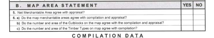

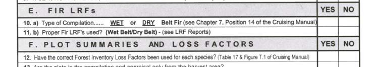


257 Pricing Branch Forms FS 697 Provincial Compilation Check Form Figure F.6 FS Provincial Compilation Check Form. May 15, 2010 F-7


258 Cruising Manual Ministry of Forests and Range FS 698 Provincial Comparative Cruise Checklist Figure F.7 FS 698 Provincial Comparative Cruise Checklist. F-8 May 15, 2010
259 Pricing Branch Forms Acknowledgements 1. The colour photographs that are in Section A.4.4 were contributed by the Canadian Forest Service. 2. The Forms, Risk group rating tables and Interior Site Index Tables were compiled by the Kamloops Forest Region. 3. The Down Tree Matrix was provided by the Kamloops Forest District. May 15, 2010 F-9
260 Cruising Manual Ministry of Forests and Range This page is intentionally left blank. F-10 May 15, 2010
261 Glossary Accuracy AAC (Allowable Annual Cut) Absolute Variation BAF (Basal Area Factor) Bias The nearness of a measurement to the actual value of the variable being measured. The rate of harvest determined by the Chief Forester for Timber Supply Areas (TSA's) and Tree Farm Licences (TFL's), and by the District Manager for Woodlot Licences (WL's), and the rate of harvest specified for a licence or in a management plan. The difference between two measurements or a standard and a measurement, disregarding the plus or minus sign (e.g., standard of 7 and measurement of 5 gives absolute variation of 2). Basal Area Factor or "BAF". Prisms come in a wide variety of sizes. They are classified by "diopter" size. The size denotes the basal area per hectare that each "in" tree represents (i.e., an 8 prism which tallies 7 trees in a plot would give a basal area (in timber) of 56 m 2 /hectare). Measurement bias occurs when the mean of the measured values differs from the mean of the actual values. Sampling bias occurs when certain sampling units are more likely to be included than others (lack of randomness). Statistical bias occurs when the expected value of the statistic differs from the population parameter. Boring-Height Breakage The boring-height is the distance from the ground (high-side) up the tree to where an age is taken with an increment-borer. It is always taken at dbh (1.3 m) above high-side. Breakage is defined as any piece broken at both ends and shorter than 3 m which results from normal falling or yarding/forwarding operations. May 15, 2010 G-1
262 Cruising Manual Ministry of Forests and Range Breast-Height Catastrophic Losses Cardinal Closure Error Coast Coefficient of Variation (CV) Confidence Count-Plot Crown-Class The location on a tree where its diameter (dbh) is taken. It is located exactly 1.3 m above "high-side". Damage to timber from fire, windfall, insects or disease that inflicts losses well above the norm reflected in the forest inventory for the locality or region. North, South, East and West. In a closed traverse, the closure error is the distance between the start and end of the traverse, divided by the length of the traverse, and is usually expressed in percent. It can also be calculated by taking the square root of the sum of the squared sum of latitudes plus the squared sum of departures. A closure error of 1 percent will result in an area error of approximately 2 percent. Refer to the Coast Appraisal Manual for the definition of the Coast. A relative measure of variation, equal to the sample standard deviation expressed as a percentage of the sample mean. An expression of accuracy of sample estimates, usually assessed by confidence intervals, a specified proportion of which, such as 95 percent confidence intervals, contain the true population parameters. A prism plot where only the number of "in" trees by species is noted. No individual tree measurements are taken. Enhanced count-plots have some measurements taken as required (i.e., diameters or heights). Trees are classified into four crown classes. They are dominant, co-dominant, intermediate and overtopped (see Figure 3.10). G-2 May 15, 2010
263 Pricing Branch Glossary Cutblock Cutting Authority Area A discrete area covered by a form of licence and logged according to an approved harvesting plan. The authority to harvest Crown timber, as provided by the Forest Act. (Cutting authority area means a Timber Sale Licence, a Licence to Cut, a Road Permit, or a cutting permit issued under a Tree Farm Licence, Forest Licence, Timber Licence or a Woodlot Licence.) Cutting Specifications DBH (Diameter Breast Height) Decay, Waste and Breakage (DWB) DIB (Diameter Inside Bark) Diopter Double-Sampling Endemic Losses The timber merchantability specifications in the Cutting Permit document. The outside-bark diameter of a tree taken at breast-height (1.3 m above the high side of the ground). Factors to reduce the gross merchantable volume to a net utilizable volume and to approximate the provincial volume depletion due to decay, firmwood waste and breakage due to harvesting. The statutory authority to allow for DWB is in the Forest Act, Part 2, Section 8(8)iv. The inside-bark diameter of a tree. It can be anywhere along the stem of the tree from the base to the top. One way of denoting prism "size". A value of one diopter represents a right-angled deflection of one unit per one hundred units in distance. The formula for converting diopter size to baf size (metric) is: baf = 10,000 / 1+. diopters This sampling method incorporates a second sampling procedure where only some of the characteristics of the main sampling method are noted. An example is measure and countplots established on a cut-block. The major reason for using this method is the savings in time and therefore money because the count-plots take much less time to put in. Damage to timber from normal populations of insects or disease that inflicts average losses over the long term for the locality or region. The forest inventory provides net merchantable volumes which reflect "endemic" (average or normal) losses. May 15, 2010 G-3
264 Cruising Manual Ministry of Forests and Range Enhanced Count Plot Faller Selection Fixed-Area Plot Sampling Forest Inventory Zone GPS (Global Positioning System) High-Side Interior Licensee A count plot where some individual tree species measurements or specific tree attributes are measured to improve the estimate for the species or specific attributes. This timber falling technique applies to selection logging in cutting authorities where the cut and leave trees are not marked and the faller decides which trees to cut or leave. The decision is based on the partial cut prescription and safety considerations. A sampling method where a fixed amount of area is sampled in each plot within a stratum. All trees above the timber merchantability specifications are tallied regardless of their distance from plot centre. All plots within a stratum must be the same size and shape. British Columbia is segregated into 12 forest inventory zones. All commercial tree species were sampled for volume and decay by the Inventory Branch of the Ministry of Forests (now the Ministry of Sustainable Resources Management). All regions of the province were sampled and areas of similar timber types and climatic conditions were grouped into a common Forest Inventory Zone to produce DWB factors. A method of accurately determining or relocating a ground position using the signal from several satellites simultaneously. A small portable computer evaluates the time for each signal to reach it and then computes a three dimensional location. The position where the ground meets the tree on the (uphill side side of the stump adjacent to highest ground), ignoring any root flare, obstacles, vegetation, and loose matter that has accumulated at the base of the tree. Refer to the Interior Appraisal Manual for the definition of the Interior. The holder of the cutting authority area. G-4 May 15, 2010
265 Pricing Branch Glossary Log Grade Major Species Minor Species Mean (Mode & Median) Merchantable Mean Absolute Variation Variation: Mean Absolute Variation: Those log grades that are defined in the Scaling Regulation. Comprises 20 percent or more of total gross volume in a timber type, cut-block or cutting permit. Comprises less than 20 percent of the total gross volume in a timber type, cut-block or cutting permit. The "mean" of a set of measurements is the sum of all measurement values divided by the number of measurements. The "mode" of a set of measurements is the value which occurs most often or with the greatest frequency. The "median" of a set of measurements arranged in an increasing order of magnitude is the middle value (or arithmetic mean of the two middle values). A segment of a tree at least 3 metres long with a top diameter inside bark that meets or exceeds the timber merchantability specifications. The arithmetic mean of a set of absolute variations. The difference, plus or minus, between two measurements or a standard and a measurement (e.g., standard of 7 and measurement of 5 gives variation of -2). The arithmetic mean of a set of absolute variations. 100% Cruise A cruise in which every tree is measured. There are no samples or estimates. Partial Cutting Pathological Indicators Percent Reduction A variety of silviculture systems in which a stand may be cut to ensure regeneration. In a Partial Cutting system, only some of the trees are felled during the harvesting phase. The selection method may specify "removal" or "leave" trees. Some examples of selection criteria are diameter, species, volume, age, height, disease or other damage. They include conk, blind conk, scar, fork or crook, frost crack, mistletoe, rotten branch, and dead or broken top. In reference to partial cutting, this refers to a specified percent reduction of the total cruise volume which is targeted to be left or to be cut and removed. May 15, 2010 G-5
266 Cruising Manual Ministry of Forests and Range PRF (Plot Radius Factor) In prism cruising, each tree has its own plot radius. This is a function of tree diameter (dbh) and prism baf size. The plot radius factor (prf) times the dbh gives the appropriate plot radius for any tree. The prf formula is: prf =0. 5/ baf Plot Sampling Precision Recompilation Residual Risk-Group Sampling Error (S.E.) Site-Class The estimation of volumes and grades by species within a cutblock from sample plot measurements, and the determination of the sampling error associated with the plot estimates. The closeness, to each other, of repeated measures of the same quantity, expressed as Sampling Error or Standard Error of the sample estimate. A second or subsequent cruise compilation with some plots added or deleted, or both. Living trees with none of the eight pathological indicators. As the name implies, this is simply a grouping by expected "risk" or probability of average decay, waste and breakage, for volume deduction by individual tree. These take the form of from one to three "risk-groups" which are individually specified for each tree species by age and location (Forest Inventory Zone) in the Province. Each risk-group (by species and location) keys to a loss factor table with volume deductions for decay, waste, and breakage. The pathological indicators place each tree into a tree-class. Various tree-classes are grouped together into one of three risk groups which in turn determine the severity of the deductions for volume. The expressing of the accuracy of the sampling of the cruise. It is calculated as a percent of an estimated mean to a desired probability. A set of 4 site quality classes (good, medium, poor, low) which characterize the potential growth capacity of the minerals and moisture in the soil, as measured in tree height (metres) attained at the breast-height age of 50 years. G-6 May 15, 2010
267 Pricing Branch Glossary SD (Standard Deviation) Stratum Stratification Strip-Line Stumpage Amount Stumpage Rate Suspect Tie-Point Timber Supply Area Top-Height Tree-Class The Standard Deviation is the square root of variance. It characterizes dispersion of individuals about the mean and gives some idea whether most of the individuals in a population are close to the mean or spread out. On the average, about two-thirds of the unit values of a normal population will be within one standard deviation of the mean. About 95 percent will be within two standard deviations and about 99 percent within 2.6 standard deviations. A specified portion of a sub-population area for which separate volumes and sampling statistics are calculated. A subpopulation may be made up of one or many strata. Strata are commonly known as timber types. The process of delineating strata boundaries within a subpopulation, where each stratum has unique characteristics such as species composition, height, stand volume or age. A ribboned line running through the forest and tied to a baseline and/or boundary at one or both ends. Cruise plots are located at regular intervals along each strip. This is the charge levied by the Crown for a specific volume of timber that is determined by either a scale or a cruise. The stumpage amount is determined by multiplying the stumpage rate by the volume of timber in cubic meters. The stumpage rate is determined in accordance with the policies and procedures approved for the forest region by the minister. A living tree with one or more pathological indicators. An important point from which a boundary, base-line or cruise strip is "tied" into (e.g., legal lot corner (I.P.); creek and road junction (mapped)). Large contiguous areas of Crown land on which an annual allowable cut is calculated. The mean height of the 100 trees per hectare of largest diameter. A series of classes (nine) primarily used for age/maturity and live/dead classification. This classification puts each tree into the appropriate risk-group for volume deduction. May 15, 2010 G-7
268 Cruising Manual Ministry of Forests and Range True Variance Waste Refers to height, diameter, number, sum, plot volume, LRF, or other variable. The "true" value is determined by the Forest Service. The mean of squared deviations of observations about a sample mean. (These deviations or differences from the mean are called residuals). In the timber cruising compilation programme, decay, waste and breakage are deducted from the gross tree volume. The waste component is the firmwood volume associated with 5 m logs in a tree which contain less than 50 percent of their gross scale in firmwood volume. These logs are assumed to be left on the cut-block and so their remaining firmwood volume is then classified as waste. G-8 May 15, 2010
269 Appendices May 15, 2010 A-1
270 Cruising Manual Ministry of Forests and Range Appendix 1 Age and Height Class Limits Table A.1 Age Class Limits Age and Height Limits for Age in Tens Age Limits Age Limits Age Limits Height Class Limits for Height in Threes Height Limits Height Limits Height Limits A-2 May 15, 2010
271 Pricing Branch Appendices Appendix 2 Magnetic Declination 2010 Region Location Latitude Longitude Declination Declination (in degrees, minutes) Degree, Min. Decimal Deg. Coastal Chilliwack 49 10' 121 ο 57' 17 19' E 17.3 E Coastal Haney 49 13' 122 ο 36' 17 28' E 17.5 E Coastal Abbotsford 49 03' ' 17 21' E 17.4 E Coastal Vancouver 49 15' ' 17 35' E 17.6 E Coastal Squamish 49 45' ' 17 44' E 17.7 E Coastal Powell River 49 51' ' 18 01' E 18.0 E Coastal Campbell River 50 01' ' 18 11' E 18.2 E Coastal Port McNeill 50 35' ' 18 36' E 18.6 E Coastal Gold River 49 41' ' 18 11' E 18.2 E Coastal Nanaimo 49 10' ' 17 42' E 17.7 E Coastal Tofino 49 07' ' 17 58' E 18.0 E Coastal Duncan 48 47' ' 17 32' E 17.5 E Coastal Port Alberni 49 14' ' 17 51' E 17.9 E Coastal Sayward 50 23' ' 18 24' E 18.4 E Coastal Holberg 50 39' ' 18 42' E 18.7 E Coastal Port Renfrew 48 33' ' 17 35' E 17.6 E Coastal Massett 54 01' ' 20 04' E 20.1 E Coastal Haida Gwaii (formerly Queen 53 15' ' 19 47' E 19.8 E Charlotte City) Coastal Klemtu 52 35' ' 19 25' E 19.4 E Coastal Hagensborg 52 23' ' 19 10' E 19.2 E Coastal Security Bay 51 22' ' 18 54' E 18.9 E Coastal Alison Sound 51 15' ' 18 49' E 18.8 E Coastal Pemberton 50 19' ' 17 55' E 17.9 E Coastal Boston Bar 49 52' ' 17 26' E 17.4 E Coastal Stuart Island 50 22' ' 18 17' E 18.3 E Coastal Sewell Inlet 52 53' ' 19 39' E 19.7 E Coastal Franklin River 49 00' ' 17 46' E 17.8 E Coastal Rivers Inlet 51 41' ' 19 00' E 19.0 E Coastal Prince Rupert 54 18' ' 20 09' E 20.2 E Northern Burns Lake 54 14' ' 19 45' E 19.8 E Northern Houston 54 27' ' 19 56' E 19.9 E Northern Smithers 54 47' ' 20 07' E 20.1 E Northern Hazelton 55 14' ' 20 20' E 20.3 E Northern Terrace 54 31' ' 20 09' E 20.2 E Northern Stewart 55 57' ' 20 46' E 20.8 E Northern Lower Post 59 55' ' 22 21' E 22.4 E Northern Bob Quinn Lake 56 58' ' 21 10' E 21.2 E Northern Dease Lake 58 26' ' 21 46' E 21.8 E Northern Atlin 59 35' ' 22 09' E 22.2 E Southern Valemount 52 50' ' 17 49' E 17.8 E Southern McBride 53 18' ' 18 15' E 18.3 E Northern Hixon 53 25' ' 18 53' E 18.9 E Northern Prince George 53 55' ' 19 06' E 19.1 E Northern Bear Lake (Hart Hwy) 54 30' ' 19 18' E 19.3 E Northern Vanderhoof 54 01' ' 19 23' E 19.4 E Northern Kenny Dam 53 35' ' 19 23' E 19.4 E May 15, 2010 A-3
272 Cruising Manual Ministry of Forests and Range Region Location Latitude Longitude Declination Declination (in degrees, minutes) Degree, Min. Decimal Deg. Northern Ft. St. James 54 26' ' E 19.6 E Northern Takla Landing 55 29' ' 20 15' E 20.3 E Northern Manson Creek 55 40' ' E 20.1 E Northern Aiken Lake 56 26' ' 20 36' E 20.6 E Northern Bear Lake (Driftwood) 56 12' ' 20 39' E 20.7 E Northern Mackenzie 55 18' ' 19 43' E 19.7 E Northern Fort Ware 57 26' ' 21 00' E 21.0 E Northern Ingenika Point 56 47' ' 20 37' E 20.6 E Northern Ingenika Mine 56 42' ' 20 38' E 20.6 E Northern Dawson Creek 55 46' ' 19 09' E 19.2 E Northern Chetwynd 55 42' ' 19 31' E 19.5 E Northern Tumbler Ridge 55 07' ' 19 08' E 19.1 E Northern Fort St. John 56 15' ' 19 31' E 19.5 E Northern Beaton River (settl.) 57 23' ' 20 07' E 20.1 E Northern Pink Mountain 57 02' ' 20 15' E 20.3 E Northern Fort Nelson 58 48' ' 21 02' E 21.0 E Northern Muncho Lake 58 56' ' 21 39' E 21.7 E Northern Nelson Forks 59 30' ' 21 37' E 21.6 E Southern Chase 50 49' ' 17 17' E 17.3 E Southern Lillooet 50 40' ' 17 48' E 17.8 E Southern Merritt 50 07' ' 17 21' E 17.4 E Southern Princeton 49 28' ' 17 05' E 17.1 E Southern Penticton 49 30' ' 16 51' E 16.9 E Southern Vernon 50 16' ' 17 00' E 17.0 E Southern Salmon Arm 50 42' ' 17 08' E 17.1 E Southern Kamloops 50 40' ' 17 25' E 17.4 E Southern Clearwater 51 39' ' 17 39' E 17.7 E Southern Beaverdell 49 26' ' 16 42' E 16.7 E Southern Castlegar 49 19' ' 16 14' E 16.2 E Southern Cranbrook 49 30' ' 15 38' E 15.6 E Southern Creston 49 06' ' 15 48' E 15.8 E Southern Flathead 49 22' ' 15 10' E 15.2 E Southern Golden 51 18' ' 16 35' E 16.6 E Southern Grand Forks 49 02' ' 16 24' E 16.4 E Southern Invermere 50 31' ' 16 01' E 16.0 E Southern Kaslo 49 55' ' 16 09' E 16.2 E Southern Mica Creek 52 00' ' 17 20' E 17.3 E Southern Nakusp 50 14' ' 16 33' E 16.6 E Southern Nelson 49 29' ' 16 10' E 16.2 E Southern Revelstoke 50 59' ' 16 54' E 16.9 E Southern Sparwood 49 43' ' 15 22' E 15.4 E Southern Quesnel Townsite 52 59' ' 18 43' E 18.7 E Southern Farwell Canyon 51 49' ' 18 19' E 18.3 E Southern Mid - Horsefly Lake 52 24' ' 18 10' E 18.2 E Southern 100 Mile House Townsite 51 39' ' 17 58' E 18.0 E Southern Chilanko Forks Settlement 52 07' ' 18 43' E 18.7 E Internet Site: A-4 May 15, 2010
273 Pricing Branch Appendices Appendix 3 Forest Inventory Zones Figure A.1(a) Forest Inventory Zones. May 15, 2010 A-5
274 Cruising Manual Ministry of Forests and Range Figure A.1(b) Forest Inventory Zones. A-6 May 15, 2010
275 Pricing Branch Appendices Figure A.1(c) Forest Inventory Zones. May 15, 2010 A-7
276 Cruising Manual Ministry of Forests and Range Figure A.1(d) Forest Inventory Zones. A-8 May 15, 2010
277 Pricing Branch Appendices Figure A.1(e) Forest Inventory Zones. May 15, 2010 A-9
278 Cruising Manual Ministry of Forests and Range Figure A.1(f) Forest Inventory Zones. A-10 May 15, 2010
279 Pricing Branch Appendices Figure A.1(g) Forest Inventory Zones. May 15, 2010 A-11
280 Cruising Manual Ministry of Forests and Range Figure A.1(h) Forest Inventory Zones. A-12 May 15, 2010
281 Pricing Branch Appendices Figure A.1(i) Forest Inventory Zones. May 15, 2010 A-13
282 Cruising Manual Ministry of Forests and Range Figure A.1(j) Forest Inventory Zones. A-14 May 15, 2010
283 Pricing Branch Appendices Figure A.1(k) Forest Inventory Zones. May 15, 2010 A-15
284 Cruising Manual Ministry of Forests and Range Figure A.1(l) Forest Inventory Zones. A-16 May 15, 2010
285 Pricing Branch Appendices Appendix 4 Pathological Classification of Trees Within mature stands, or stands approaching maturity, (i.e., older immature stands) individual trees contain varying amounts of decay. Thus, in stands of this type the estimation of cull is subject to considerable error. Therefore, it would be advantageous to know which trees are likely to contain decay, particularly those which are likely to contain excessive amounts of decay. Recent pathological studies have shown that two broad classes of living trees are clearly recognizable in stands of this character. As the classification of trees is made on the basis of the presence or absence of external signs of decay, it is anticipated that each class of tree so defined will represent a different potential loss factor within the stand. A.4.1 Class of Trees All living trees measured on each sample plot will be classed as: residual, or suspect. A Suspect Trees Suspect trees are living trees which bear one or more of the following external indications of decay, on or immediately adjacent to the trunk of the tree within the limits specified. 1. Conks. 2. Blind conks (swollen knots). 3. Scars. 4. Fork or pronounced crook. 5. Frost crack. 6. Trunk infections or mistletoe. 7. Rotten branches. 8. Dead or broken top. "Suspect" classifications will be made on the basis of the above signs of decay only; no other abnormalities are to be used. See Table 18 for Pathological Occurrence by Species and Forest Inventory Zones. May 15, 2010 A-17


286 Cruising Manual Ministry of Forests and Range A Residual Trees Residual trees are living trees which bear none of the external indications of decay listed above. It must be pointed out that these signs and defects are expressive of decay in the stand, rather than in individual trees. The amount of decay indicated by signs will be subject to considerable variation within species and individual trees. For example, frost cracks may be highly significant as indicators of decay on a particular species in the stand as a whole, but not as significant on individual trees. 1 Conk 2 Trunk Mistletoe 3 Frost Crack 4 Fork 5 Scar 6 Dead or Broken Top Figure A.2 Suspect Trees. A-18 May 15, 2010
287 Pricing Branch Appendices A.4.2 Signs and Defects Indicative of Decay in Standing Trees The following is a brief description and explanation of the external indications of decay listed in Section A Coast - Pathological indicators must be recorded on all live and dead potential trees. Interior - Pathological indicators must be recorded on: i. all live trees, and ii. dead potential white pine, hemlock and balsam trees, and iii. dead potential Lodgepole pine trees with conk and blind conk. Do not record pathological indicators above 10 cm diameter. Secondary Leaders Record all pathological indicators on secondary leaders if the leader is alive and of merchantable size. Conks of an identifiable heart rot fungi may be called on nonmerchantable live secondary leaders. Do not record any pathological indicators on dead secondary leaders. Record pathological indicators on dead, merchantable secondary leaders for cedar and cypress only. Record all pathological indicators on dead potential trees for the coastal log grade algorithm except do not record sap rot fungi as conk. A Conks Conks are the fruiting bodies (sporophores) of decay fungi and are definite and reliable indicators of decay. Conks occur anywhere on the main stem, branches and exposed roots of the tree but appear most frequently around knots and on the underside of both dead branch stubs and live branches. For current cruising purposes, only specific root, butt and heart rot conks are suspect indicators. Slash conks are not suspect indicators (see Figure A.6 for a list of host species for selected decay fungi). It is important to be able to differentiate between the fruiting of slash fungi that occur on dead branches and wounds of living trees and those that occur on the roots, live branches and trunks of living trees. It is necessary to be able to recognize the conks of the major heart rotting fungi found on living conifers and hardwoods. On conifers, the main conks to recognize are, Echinodontium tinctorium, Phellinus (Fomes) pini, Phaeolus (Polyporous) schweinitzii and Fomitopsis (Fomes) pinicolii. On hardwoods, the main conks are Phellinus igniarius and Phellinus tremulae. See the following host list for major and some minor heartwood decay species. May 15, 2010 A-19
288 Cruising Manual Ministry of Forests and Range The major heart rot conks are hard, thick, woody-like perennial structures and form singly at branch stubs or in small clusters on the underside of living branches. An exception is the mushroom-shaped to bracket-like sporophore of P. schweinitzii that is annual but may persist for more than two years. Before calling conks on living branches in the upper crown, there must be fruiting bodies of the heart rot fungus evident in the stand. Slash conks that occur on dead wood of living trees can be both annual (small, thin, leathery) and perennials, are often more numerous and occur anywhere on the tree. The slash conks that occur on old exposed wounds are not allowed as suspect indicators. An exception is the conk of F. pinicola, which is common on dead trees but may also occur on large, old wounds as studies have found its occurrence indicates significant decay. However, F. pinicola that occurs on dead branches is not a suspect indicator. Conks vary in size and shape and therefore are hard to spot, particularly when they are just developing or occur on the upper trunk. Conks of E. tinctorium and Phellinus pini, frequently appear as a small hoof-like or shelf-like structure on the underside of dead branch stubs on the middle and/or lower trunk of an infected tree. Moss-covered branch stubs and burls often resemble conks, particularly when viewed from directly below; it is important therefore to view the tree from the side before making a decision. Conks of Phaeolus schweinitzii P. schweinitzii is the cause of brown cubical root and butt rot of most conifers but Douglas-fir and spruce are the most susceptible. The fruiting bodies may occur: on the base of a tree, on the ground up to 2 m from the tree where no exposed roots are evident, or on the exposed roots. If a conk is mid-way between: 1. Two living susceptible trees only one tree is considered to be infected. 2. A highly susceptible species (e.g., Douglas-fir) and a less susceptible species (e.g., red cedar), the most susceptible species is considered to be infected. 3. A living tree and a stump showing brown cubical rot, and it is not on a root of the live tree, it is assumed to be associated with the stump. A-20 May 15, 2010
.")
289 Pricing Branch Appendices Figure A.3 Example of Schweinitzii. A Blind Conks Blind conks are pronounced swellings or depressions around knots caused mainly by P. pini on conifers and P. tremulae on aspen and if identified correctly, are definite indicators of decay (see Figure A.4). The swelling or depression results from the tree attempting to heal over an abortive conk; a newly developing conk; or a point from which an old conk has dropped. Non-typical forms may appear as small branch holes or branch stubs at the base of trees. This form is often found in over-mature Douglas-fir and balsam species in the coast-interior transition zone (e.g., Boston Bar). Therefore overmature trees with basal branch stubs should be examined for blind conk. May 15, 2010 A-21

290 Cruising Manual Ministry of Forests and Range Figure A.4 Example of Blind Conk in a Knot. A-22 May 15, 2010

291 Pricing Branch Appendices Figure A.5 Non-blind Conk in a Knot. May 15, 2010 A-23
292 Cruising Manual Ministry of Forests and Range Accessible indicators: must be verified by cutting with an axe or equivalent implement. This will reveal a bright yellow or buff-colour of the conk. Inaccessible indicators: call only those indicators which have a high chance of being blind conk such as large swollen knots and large caved-in knots. They must be similar to the ones that have been identified in the stand, and do not call small knots and knot indicators on any species. Large holes left by fallen large rotten branches may not be blind conk suspect indicators. A-24 May 15, 2010
293 Pricing Branch Appendices Figure A.6 Host List. May 15, 2010 A-25
294 Cruising Manual Ministry of Forests and Range Figure A.7 Blind Conk and Sound Knot. A Scars A scar is an injury caused by external forces which has damaged the cambial layers of the tree and exposes either the sap wood or heartwood (or both) to potential attack by wood rotting fungi. These wood rotting fungi are ever present in forest stands and are carried widely by air currents. Forms of scars - both open and closed scars will be called. Open scars: open scars appear as areas of exposed wood of varying sizes and shapes (see Figure A.10), and scars are slow to heal over and the wood tissues of the tree may remain exposed for a considerable time allowing entrance of wood rotting fungi. For root scars to be eligible calls, the scar must be on the portion of the root that is exposed before it enters the ground. A-26 May 15, 2010
295 Pricing Branch Appendices Figure A. 8 Root Scars. Closed scars: closed scars appear as slight to pronounced indentations of the bark in the case of early scarring which has healed over, or as pronounced scar tissue or callous growth in the case of later scarring. The latter type of scars frequently show considerable resin flow (see Figure A.9). Figure A.9 Closed Scars. May 15, 2010 A-27
296 Cruising Manual Ministry of Forests and Range Figure A.10 Open Scars. The volume and decay studies of the past thirty years identified only scars visible to the naked eye without the use of binoculars or other lens. The scars were assessed without chopping into the indicator. To be compatible with these initial assessments, the same methodology must therefore be followed today. This also is the most practical method of observation at present. A scar may or may not have visible decay associated with it. The decay studies have scars with both decay and no decay in the data base. Causes of scars: Scars may be caused by many external forces, such as: 1. Fire: old fire scars that have healed over appear typically as slight ridging of the bark and may have very old callous tissue on the bark, whereas more recent fire scars or ones resulting from severe damage appear as open catfaces or hollowing of the stem, fire scars are usually confined to the base of the tree, and fire scars may be important indicators of decay. Trees growing in forest stands (i.e., south or west facing slopes with pioneer species such as Fir or Lodgepole A-28 May 15, 2010
297 Pricing Branch Appendices Pine) having a history of fire should be examined carefully for evidence of charred wood in root crotches or on exposed roots. 2. Lightning: lightning can cause extensive damage to the top and stem of the tree. It typically appears as narrow to wide strips of torn wood, often extending down the entire length of the tree and often in the form of a spiral around the stem. 3. Damage by a falling tree: trees are frequently scarred by other trees falling against them. Scars of this type are common in selectively logged stands or decadent stands where windfall trees are more common. 4. Machinery damage: machinery can cause extensive damage, especially where selective logging has occurred, and these scars are usually confined to the lower trunk, but they may also occur on the upper trunk when damage is caused by rigging lines. 5. Blazes: blazes are entry points for decay fungi if they penetrate into the cambium layer. 6. Breakage of branches, secondary leaders or suckers from the bole of the tree: high winds or heavy snows may cause the above to break from the main stem creating exposed wood. 7. Falling rocks (see Figure A.12): rock slides or individual rock movement can cause extensive damage to trees in their path, scars caused by rocks are usually confined to the basal portion of the trunk on the uphill side, and falling rocks may in some instances scar trees a considerable height above the ground, either due to snow levels at the time of injury or bouncing rocks on steeper slopes. 8. Animal/bird damage: wood must be exposed, May 15, 2010 A-29
298 Cruising Manual Ministry of Forests and Range bear, moose, deer etc. can cause damage by removing areas of bark and cambium from the trunks of many trees, rodents and beavers also cause damage to trees by gnawing on areas of the trunk, woodpecker holes of considerable size provide entrance for wood rotting fungi, however, sap sucker holes are not scars, and care must be taken to exclude superficial damage caused by these agents. 9. Cankers caused by fungi (see Figure A.11): only cankers with exposed weathered wood are called, and cankers caused by fungi result in the death of localized areas of bark and cambium on the trunks of trees. Eventually the dead bark is sloughed off exposing the underlying wood. There is usually evidence of repeated callous growth, and for this reason cankers are frequently mistaken for mechanical scars. Cankers are usually flattened and elongated, and may be indefinite in contour. The exposed wood is often stained and impregnated with resin. Fruiting bodies of the fungus may also be in evidence. The calling of scars as pathological indicators: a scar which extends from the first or second third of the tree into the upper 1/3 of the tree on which the top is dead will be classified as a scar "4" by convention, and scars occurring completely below the point of germination either on the lower trunk or root collar adjacent to the trunk will be classified as a scar. Figure A.11 Cankers Caused byfungi. A-30 May 15, 2010
299 Pricing Branch Appendices Figure A.12 Scars Caused by Rock Slides and Falling Rocks. Age of scar: a scar shall be not recent in origin. This is interpreted as the injury having not occurred within approximately the past five years, the scar or catface should show greyed or weathered wood. Weathered wood shall be described as: dried and some "sun checking" evident, usually associated with change of wood colour to a greyish tone, callous growth should also be evident where the tree is attempting to grow over the scar, and decay does not have to be evident. Location of scar: a scar should be called if the damage occurs on any portion of the trunk of the main stem or on the secondary leader (only if the secondary leader contains a merch log), a scar which extends from the first or second third of the tree into the upper 1/3 of the tree on which the top is dead will be classified as a scar "4" by convention. The objective is not to double call the pathological indicators in the upper 1/3 of the tree, scars occurring completely below the point of germination, either on the trunk or an exposed root adjacent to the trunk, will be classified as a scar, and do not record scars above 10 cm top diameter. May 15, 2010 A-31
300 Cruising Manual Ministry of Forests and Range Abnormalities similar to scars but not classified as scars: Black knots: black knots frequently develop around unhealed knots and wounds. A superficial saprophytic fungus, which feeds on the exuded sap, causes the blackness. Black knots are quite sound and when cut into with an axe do not signify decay. Burls and galls: burls and galls develop from abnormal cell growth in trees and are not associated with scarring, however scars occurring on burls and galls will be called. Dry side: dry side results from the death of the cambium through bruising by other trees or by other physiological causes. Dry side may appear as a narrow to wide strip or as a localized area on the side of a tree. The bark remains over the affected area and provides protection against wood rotting fungi. Dry side is not a scar unless the bark has sloughed (is missing). Sap sucker holes: sap sucker holes are superficial in extent and have no established significance for causing decay. Insect borings: borings by bark beetles or other insects are generally recent in origin and they are not pathological indicators. A Fork or Pronounced Crook A fork or crook is the result of damage to the main leader of the tree where one or more lateral limbs take over as the main stem. Fork or crook is called if severe enough to indicate that the original injury exposed the wood and provided an entrance point for decay fungi. Fork or crook are to be called between the root collar and the minimum top diameter specified in the cutting authority document. Forks are called for any of the following conditions: 1. The main stem is markedly forked to indicate that 2 or more leaders have resulted from serious damage to the original leader (see Figure A.13, Example A and B). 2. The diameter of the main stem changes excessively from its normal taper to indicate that a serious injury has occurred. For cruising purposes, the diameter change must be at least 10 percent (see Figure A.12, Example C and D). A-32 May 15, 2010
301 Pricing Branch Appendices 3. Where there is not evidence of a broken top in the stem at the fork/crook position and neither of the leaders are merchantable, record fork/crook. Crooks are called if: 1. There is at least a 10 percent diameter change in the bole above and below the crook (see Figure A.13, Example F). 2. The offset is severe enough to indicate that damage occurred to the main stem. For cruising purposes, the offset must be at least 50 percent of the diameter of the tree at the crook (see Figure A.13, Example E). Some forks and crooks are not called (see Figure A.28). Forks and Crooks may be a growth characteristic of the tree species (for example deciduous species) or may have developed from malformation of the terminal leader due to insect or mistletoe attack. In addition, a fork may be confused with a branch. Forks or crooks which are not called are as follows: 1. Crooks with a minor offset (for cruising purposes, an offset less than 50 percent of the diameter of the tree at the crook). 2. Small sharply angled branches or spikes (for cruising purposes, less than a 10 percent change in the diameter of the main stem). 3. Natural forking in deciduous tree species. 4. If the damage is less than 5 years old and/or occurs above the minimum timber merchantability specifications specified in the Timber Utilization Policy (Coast or Interior). 5. Flattening of the top of the tree caused by wind or natural outgrowth. 6. Candelabra branches in coniferous species. May 15, 2010 A-33
302 Cruising Manual Ministry of Forests and Range Figure A.13 Types of Forks and Crooks Which are Recorded. Examples A and B illustrate forks which occur in the merchantable portion of the trunk. Example C illustrates forks which occur on the basal portion of trees. Examples E and F illustrate pronounced crook. A-34 May 15, 2010
303 Pricing Branch Appendices Figure A.14 Fork or Crook and/or Dead or Broken Top. 1. If the forked leaders exceed the dimensions of a log as defined by the merchantability specifications (i.e., A is estimated to be greater than 3 m, and B is greater than 10 cm dib then record a fork) call the pathological defect as a fork. 2. If the leader material is relatively small in size (i.e., less than 3 m in length) call the defect as a dead or broken top. 3. In no instance should you double call any pathological indicators (i.e., either call a fork or a dead top, not both!). A is estimated length of log that could be obtained from the forked leader. B is estimated to 10 cm top. C is dead top or broken top. If a merchantable fork has broken off and has been on the ground for greater than or equal to 5 years, the fork and scar may be recorded. May 15, 2010 A-35


 for the")


304 Cruising Manual Ministry of Forests and Range Figure A.15 Fork/crook. Record a down tree code (clean break) since the fork is long enough to produce a merchantable log. Record fork and scar if the injury is at least 5 years old. See Figure A.40 or the back of the cruise tally card (FS 205) for the down tree codes. See Section A for details regarding the coding of scars and see Section A.4.2 for details regarding the coding of pathology on secondary leaders. A-36 May 15, 2010
305 Pricing Branch Appendices A Frost Cracks frost cracks result from deep radial splitting of the trunk caused by uneven expansion of the wood after sudden and pronounced drops in temperature, the cracks usually originate at the base of the trunk and extend up the tree following the longitudinal grain of the tree (see Figure A.16), frost cracks are often repeatedly opened by wind stresses or by low temperatures which freeze the moisture within the cracks and expands and splits the tree further, repeated healing of the wood produces considerable callous tissue giving the wood a pronounced ribbed appearance, and frost cracks must have occurred at least 5 years previously before they can be recorded. Frost cracks are often associated with severe basal decay. Figure A.16 Appearance of Frost Crack on Standing Trees. May 15, 2010 A-37
306 Cruising Manual Ministry of Forests and Range A Mistletoe Trunk Infections Trunk infections of mistletoe are indicated either by abnormal swelling or malformations of the trunk at the point of infection, or by clusters of dead and broken branches on the trunk or on hypertrophied branches immediately adjacent to the trunk (see Figure A.17). Figure A.17 Trunk Infections of Mistletoe. Wood-rotting fungi gain entrance to the trunk through the dead hypertrophied branches or branch stubs where the swelling is on, or adjacent to the trunk. Do not include mistletoe on living limbs or limbs that are swollen only at some distance from the trunk. Include only those branch infections in which the swelling has clearly extended to trunk (Figure A.18). Figure A.18 Branch Infections of Mistletoe. A-38 May 15, 2010
307 Pricing Branch Appendices A Large Rotten Branches Large rotten branches are dead branches that are large (over 10 cm DIB) and are clearly decayed. These branches are usually broken off within a couple of metres of the trunk. Decayed heartwood close to or at the branch base should be obvious. The branches may be found at any position on the tree, but are generally confined to a position below the base of the live crown. This indicator is typically found on overmature trees (see Figure A.19). Large rotten branches should not be confused with the normal decay of dead branches. It should be associated with large branches that have broken off, exposing a large heartwood surface to decay producing fungi, thereby potentially infecting the adjacent trunk. Figure A.19 Rotten Branches. May 15, 2010 A-39
308 Cruising Manual Ministry of Forests and Range A Dead or Broken Top Definition: where the tree top or complete stem has died due to various physiological causes. Causes of dead tops Dead tops may be caused by several factors such as: insect attack, drought conditions, sun scald, and physiological death. The calling of dead tops: a dead top must be obviously weathered, indicating that death occurred at least five (5) years ago and below the 10 cm top before it will be called as a pathological indicator, and Causes of broken tops wind breakage, snow damage, and damage from falling trees, etc. Broken tops must be obviously weathered (see scar criteria) before being called as a pathological indicator. Standing trees that are broken in the bottom third will have a windthrow damage code assigned. In this instance, do not record a dead or broken top in the first third unless the broken top occurred at least 5 years previously. If a fork is present at a broken top position, record the fork if a merchantable log (3 m long and 10 cm top) can be recovered from the fork. If the fork is not of merchantable size, record the d or b top. Do not call both indicators (see Figure A.14). If a candelabra is present at a broken top position, record d or b top. A-40 May 15, 2010
309 Pricing Branch Appendices Flat topped trees When trees attain their potential height for a specific site, the tendency for the top of the crown to flatten out is prevalent especially in certain species such as Douglas fir. This flattening of the crown is not indicative of damage to the tree and will not be called as a pathological indicator. A.4.3 Abnormalities which are not Recorded The following abnormalities are not indicative of decay and are, therefore, not recorded. A External Evidence of Butt Rot not Associated with Suspect Abnormalities Butt rot may be evident in exposed roots or within root crotches. However, unless one or more of the suspect abnormalities appears on the tree, such trees will not be classed as Suspect, it is defect of this nature which contributes to the decay loss factor associated with the Residual tree class. A Flutes Pronounced flutes on the trunk are a common growth characteristic of many species. They have no decay significance except in the case of interior cedar where the fold may hide an open scar leading to a hollow or decayed tree centre (Figure A.20). Figure A.20 Flutes. May 15, 2010 A-41
310 Cruising Manual Ministry of Forests and Range A Candelabra Branches Candelabra branches develop as a result of abnormal branch growth and as such are confused with Suspect forking. Branching of this type has no decay significance. It is important to note that candelabra branches do not originate as a fork in the trunk of a tree (Figure A.21). Do not call defect on candelabras. A Branch Fans Figure A.21 Candelabra Branches. Branch fans which appear most commonly as 'fans' of branches originating from burl-like swellings on the trunks (Figure A.22) are not Suspect. Figure A.22 Branch Fans. A-42 May 15, 2010
311 Pricing Branch Appendices A Black Knots Black knots frequently develop around unhealed knots and wounds. The blackened appearance develops from a superficial saprophytic fungus which feeds on the exuded sap. Black knots are quite sound when cut into with an axe and have no decay significance (Figure A.23). A Burls and Galls Figure A.23 Black Knots. Burls and galls develop from abnormal cell growth in trees and although formidable in appearance, have no decay significance (Figure A.24). Scars will be tallied on burls. Figure A.24 Burls and Galls. May 15, 2010 A-43
312 Cruising Manual Ministry of Forests and Range A Sweep Sweep which is a slight curvature or distortion of the trunk has no decay significance (Figure A.25). A Exposed Roots Figure A.25 Sweep. Exposed roots and buttress roots have no established decay significance unless scarring is present above mean ground level (Figure A.26). Figure A.26 Exposed Roots. A-44 May 15, 2010
313 Pricing Branch Appendices A Other Spiral Grain Spiral grain is a growth characteristic of trees and has no decay significance. Dry Side Dry side results from the death of the cambium resulting from bruising by other trees or from other physiological causes. Dry side appears as a narrow to wide strip down the side of the tree or as small localized areas. The bark often remains intact over the dead areas. Although dry side may be responsible for the complete rejection, or degrade of a pole tree, it has no established decay significance. Dry side is not a scar unless the bark has sloughed (is missing). Sap Sucker Holes Sap sucker holes are superficial in extent and have no established decay significance. They are in marked contrast to Suspect scarring caused by woodpeckers (Figure A.27). Insect Borings Figure A.27 Bird Damage. Borings by bark beetles or other insects have no established decay significance and will not be classed as Suspect. May 15, 2010 A-45
314 Cruising Manual Ministry of Forests and Range Non-Suspect Forking Figure A.28 shows two types of non-suspect forking most commonly occurring in deciduous trees. Deciduous trees with "U" shaped forks containing a dead branch are definitely suspect. Non-Suspect forking is more "V" shaped. Trees growing in clumps, such as birch, should not be classed as suspect on this characteristic alone. Figure A.28 Illustrates Forks and Crooks Which are Not Suspect. A-46 May 15, 2010
315 Pricing Branch Appendices A.4.4 Some Common Decays of Forest Tree Species in British Columbia Brief descriptions of some of the major decays of commercial tree species in British Columbia have been included as an aid to their identification in the field. Pathological studies have shown that although most tree species are subject to attack by a large number of wood-rotting fungi only a few are of major significance. Descriptions of eleven of these have been included. May 15, 2010 A-47


316 Cruising Manual Ministry of Forests and Range A Indian Paint Fungus Figure A.29 Indian Paint Fungus. A-48 May 15, 2010
317 Pricing Branch Appendices Scientific name (fungus): Common name (decay): Hosts: Sporophores: Decay: Entrance: Echinodontium tinctorium (Ell. & Ever). Brown stringy trunk rot. Reported on a large number of coniferous hosts. Of major importance in British Columbia only on western hemlock, alpine fir and amabilis fir. Reported from the coast only at higher elevations and in the north. Perennial, hard, woody, sessile, ungulate: upper surface black, furrowed; context brick-red; lower surface grey. The incipient stage may appear as a light yellow to brown or water-soaked stain. Later, the wood darkens to a reddish-brown to brownish-yellow colour. Small rustcoloured spots and occasionally red streaks may develop. Finally, the wood is reduced to a brown, fibrous, string mass. Infections occur in living branches after 35 to 45 years, but normally do not become established in the trunk for another 100 years. Conditions affecting entry into the trunk are unknown. May 15, 2010 A-49


318 Cruising Manual Ministry of Forests and Range A Pine Root Fungus Figure A.30 Pine Root Fungus. A-50 May 15, 2010
319 Pricing Branch Appendices Scientific name (fungus): Common name (decay): Hosts: Sporophores: Decay: Entrance: Activity: Remarks: Heterobasidion annosum (Fr.:Fr.) Bref. Annosus root and butt rot Occurs on most hardwoods and conifers. Common in western hemlock. Range is generally west of the coast mountains and in the ICH biogeoclimatic zone. Perennial, woody to leathery, sessile, ungulate or bracket-like to resupinate; upper surface dark-coloured to black, zones, margin acute; context white to cream coloured, poroid, pores small and regular. The incipient stage may appear as a reddish-brown stain. In the advanced stage the wood is reduced to a white stringy or spongy mass containing numerous black flecks running parallel to the grain. In the final stage the wood may be completely destroyed. Roots and scars. Heartwood and occasionally sapwood decomposition of lignin and to a lesser or slower extent cellulose. Generally confined to the roots and butt sections. Sporophores generally produced on dead material or on the undersurface of roots exposed to the atmosphere. Capable of causing extensive root rot in young stands. Also occurs as a common decay of mature timber. May 15, 2010 A-51

320 Cruising Manual Ministry of Forests and Range A Picture Conk Figure A.31 Picture Conk. A-52 May 15, 2010
321 Pricing Branch Appendices Scientific name (fungus): Common name (decay): Hosts: Sporophores: Decay: Entrance: Activity: Remarks: Ganoderma Applanatum (Pers.) Pat. Fomes applanatus Pers. White mottled rot, Applanatus rot. Known to occur on conifers, but more frequent on hardwoods in all regions of BC. Perennial, leathery to woody, sessile, applanate; upper surface light brown to grey, often shiny; context dark brown; lower surface white, turning dark brown when bruised; poroid, pores regular. The incipient stage may appear as a light stain or infected wood may have a bleached appearance and be difficult of detection. In the advanced stage the decay is characterized by a mottled appearance. The wood is white or light coloured, soft and spongy, and often contains zone lines and accumulations of mycelium. Scars. Heartwood and sapwood decomposition of lignin and to a lesser and slower extent cellulose. May occur in the butt or trunk. Sporophores develop infrequently on living trees. The lower surface of fresh sporophores may be permanently marked on contact (the picture conk). Brownish spores may be carried to the upper surface giving a dusty brown appearance to the sporophore. May 15, 2010 A-53


322 Cruising Manual Ministry of Forests and Range A Conk Fungus Figure A.32 Conk Fungus. A-54 May 15, 2010
323 Pricing Branch Appendices Scientific name (fungus): Common name (decay): Hosts: Sporophores: Decay: Entrance: Activity: Remarks: Phellinus pini (There:fr) Ames. Fomes pini (Thore) Lloyd, formerly referred to as Trametes pine (Thore) Fr. Conk rot, white-pitted rot, red ring rot, pecky rot, honeycomb rot, etc. Occurs essentially on all conifers in British Columbia, very common in hemlock, spruce and Douglas fir. Also known to occur on hardwoods. Perennial, wood to punky, sessile, ungulate, occasionally effused-reflexed if on branches; upper surface dark brown, furrowed; context cinnamon brown; lower surface light brown, poroid, pores regular to daedaloid. The incipient stage may appear as a reddish stain. Later small white, spindle-shaped pits develop parallel to the grain. Unknown - probably branches and wounds. A lignin destroying heartrot, mostly occurring in the trunk. One of the most important decay fungi in British Columbia. Of greater importance on good sites. Conks develop on living trees and provide a valuable index to hidden defect. Also recognized through the occurrence of blind conks (punk knots) which constitute early or abortive stages in the development of sporophores. May 15, 2010 A-55


324 Cruising Manual Ministry of Forests and Range A Red Belt Fungus Figure A.33 Red Belt Fungus. A-56 May 15, 2010
325 Pricing Branch Appendices Scientific name (fungus): Common name (decay): Hosts: Sporophores: Decay: Entrance: Activity: Remarks: Fomitopsis pinicola (SW.:Fr) P. Karst. Fomes pinicola (sw.) Cke. Brown crumbly rot. Common on most conifers and hardwoods. Perennial, woody to leathery, sessile, variable, ungulate, bracket-like, occasionally effused-reflexed; upper surface dark brown to black, outer margin often reddish or otherwise lighter in colour; context cream to light brown; lower surface white, often tinged with yellow; poroid, pores small and regular. The incipient stage may appear as a light brown discolouration. Later the wood breaks into small brown cubes which are soft and crumbly. White felts of mycelium may be formed in the shrinkage cracks. Scars, dead tops, insect injuries, etc. A cellulose-destroying trunk rot, occurring in the heartwood or sapwood. Very common in dead trees, slash, and other forest litter, thus occasionally known as the scavenger fungus. May be associated with decay in living trees, frequently gaining entrance through scars. Also an important rot contributing to the deterioration of killed stands, especially by fire and insects. Sporophores develop infrequently on living trees. May 15, 2010 A-57


326 Cruising Manual Ministry of Forests and Range A Velvet -Top Fungus Figure A.34 Velvet-top Fungus. A-58 May 15, 2010
327 Pricing Branch Appendices Scientific name (fungus): Common name (decay): Hosts: Sporophores: Decay: Entrance: Activity: Remarks: Phaelous schweinitzii (Fr.:Fr.) Pat. Polyporus schweinitzii Fr. Brown cubical butt rot. On conifers, common in Douglas fir, spruce and pine. Occasionally found on hardwoods found in all regions in BC. Annual, spongy to leathery, stipitate; upper surface reddish-brown; velvety with concentric rings and a light yellow margin; context yellow-green to light brown; lower surface yellow-green turning brown when bruised; pores regular to daedaloid. The incipient stage may be difficult to detect, often appearing as a light yellow stain. At a late stage the wood becomes brittle and breaks into large cubes, reddish-brown in colour. An odour of anise is often associated with advanced decay. Roots. A cellulose-destroying heartrot, generally confined to the roots and basal log. Very general distribution throughout North America. Occurs in trees of all ages. Young trees may be killed outright, older trees become subject to windfall. Sporophores develop on roots and freshly felled trees and provide a valuable index of infection. May 15, 2010 A-59


328 Cruising Manual Ministry of Forests and Range A Sulphur Fungus Figure A.35 Sulphur Fungus. A-60 May 15, 2010
329 Pricing Branch Appendices Scientific name (fungus): Common name (decay): Hosts: Sporophores: Decay: Entrance: Activity: Remarks: Laetiporus sulphureus (Bull.:Fr) Murrill. Polyporus sulphureus (bull.) Brown cubical trunk rot. Common on most hardwoods and conifers, including oak, true fir, Douglas fir and spruce in all regions in BC. Annual, spongy to leathery, sessile or stalked (stem eccentric), applanate to bracket-like; upper surface orange-yellow; context white; lower surface sulphur-yellow; poroid, pit regular. Old sporophores white and brittle. The incipient stage may appear as a light brown stain. Later the wood breaks into small brown cubes. The decay may have a 'rippled' appearance in longitudinal section and white mycelial felts may develop in the shrinkage cracks. Scars, dead branch stubs. A cellulose decomposing heartrot and occasionally saprot. May occur in the butt or trunk, generally the latter. Sporophores develop infrequently on living trees but are easily recongnized by their shape, size and colour. They decompose quickly following insect attack and weathering and seldom remain on the host past one season. May 15, 2010 A-61


330 Cruising Manual Ministry of Forests and Range A Spongy Butt Rot Complex Figure A.36 Spongy Butt Rot Complex. A-62 May 15, 2010
331 Pricing Branch Appendices Scientific name (fungus): Common name (decay): Hosts: Sporophores: Decay: Entrance: Activity: Remarks: The three fungi most commonly involved in the complex are Corticium galactinum (Fries) Bur, Odontia bicolor (Alb. and Schw. ex. Fr.) Bres., and Poria subacida (Beck) Sacc. Spongy butt rot, feather rot, white stringy butt rot. Occurs in conifers and hardwoods. Common in true fir, spruce and hemlock found in all regions of BC. Superficially similar in the three species: annual to perennial, resupinate, white, yellow or buff. The surface of C. galactinum smooth and waxy, O. bicolor cracked with age and covered with short fragile evenly-distributed teeth and P. subacida small pores. The incipient stage may appear as a light stain. Later, small white pits develop and coalesce to form masses of white spongy fibres containing small black flecks. The annual rings may separate to form a laminate decay. Finally, the wood is reduced to a spongy mass. Roots. A lignin and to a slower or lesser extent cellulose decomposing heartrot and saprot generally confined to the roots and butt. Poria subacida which formerly was considered the sole causal fungus is in some hosts now believed to be the least important of the fungi commonly associated with the disease. White spongy butt rot is widely distributed throughout North America; common in mature age classes. Sporophores of the three fungi associated with this rot are generally on the undersurface of old logs. May 15, 2010 A-63


332 Cruising Manual Ministry of Forests and Range A Bleeding Conk Figure A.37 Bleeding Conk. A-64 May 15, 2010
333 Pricing Branch Appendices Scientific name (fungus): Common name (decay): Hosts: Sporophores: Decay: Entrance: Activity: Remarks: Stereum sanguinolentum A. & S. ex. Fr. Red heart rot. Occurs on conifers. Very common in true fir, pine and white spruce. Found throughout the range of hosts in British Columbia. Annual, leathery, resupinate to effused-reflexed, forming thin crust-like layers; lower surface grey to light brown, turning blood red when bruised, surface roughened. The incipient stage is firm and appears as a reddish brown stain, in the advanced stage, the wood becomes light brown to reddish-brown, dry and friable. Mycelial sheets, white to buff in colour, may develop. Broken tops and scars of living trees. A lignin and generally to a slower or less extent cellulose destroying heartrot, generally found in the trunk. A very important decay-producing fungus, also occurs commonly as a slash destroyer. Sporphores develop occasionally on living trees, but are of limited value as indicators of defect owing to their infrequent occurrence, small size and colour. May 15, 2010 A-65


334 Cruising Manual Ministry of Forests and Range A False Tinder Fungus Figure A.38 False Tinder Fungus. A-66 May 15, 2010
335 Pricing Branch Appendices Scientific name (fungus): Common name (decay): Hosts: Sporophores: Decay: Entrance: Activity: Phellinus igniarius (L.:Fr) Quél. Fomes igniarius (L.) Gill. White trunk rot or white heart rot. Occurs mainly on hardwoods. Common in aspen and birch. Perennial conks are usually hoof-shaped, but sometimes shelflike and may obtain a width of 20 cm or more. The upper surface is greyish-black to black, dull or shiny, smooth when younger becoming rough and cracked with age. Undersurface is brown with mouths of tubes small and circular in outline. Context or interior of conk is rusty-brown, often interspersed with silver-grey flecks. Incipient stage has yellowish-white spots, streaks, or larger areas in the heartwood, the whole usually surrounded by a yellowish-green to brownish-black zone. In the advanced stage the wood is light in weight, soft, whitish, and rather uniform in texture with fine black lines running throughout. In aspen, the incipient wood is faintly coloured from light pink to straw-brown, in the intermediate stage of decay, the wood is straw to chocolate-brown, but is still hard and firm; and in the advanced stage all soft, punky wood irrespective of colour is included. Unknown - probably branches and wounds. Sporophores from on standing trees and on slash; the presence of a single sporophore generally indicates a considerable volume of decay. May 15, 2010 A-67


336 Cruising Manual Ministry of Forests and Range A Poria Obliqua Figure A.39 Poria Obliqua. A-68 May 15, 2010
337 Pricing Branch Appendices Scientific name (fungus): Hosts: Decay: Appearance: Poria obliqua (pers.) Bres. Occurs on hardwoods. This sample was found on wester paper birch (Betula papyrifera). A heart rot in living birches similar to that caused by Fomes igniarius. Fine black zone lines are a feature of the advanced stage (Example 3). Black, warty, rough, clinkerlike sterile conks are produced on living trees, appearing to issue from knots and wounds. The conks in this illustration appears in the centre of a conspicuous canker. The context or interior of the conk is rusty-brown. May 15, 2010 A-69
338 Cruising Manual Ministry of Forests and Range Appendix 5 Abbreviations and Symbols Basal area factor Close utilization Coefficient of variation Decay and breakage Decay, waste 2 and breakage Diameter at breast height Diameter at stump height Diameter inside bark Diameter outside bark Plot radius factor Standard deviation Standard error BAF CU CV DB DW2B dbh dsh dib dob PRF S.D. S.E. A-70 May 15, 2010
339 Pricing Branch Appendices Appendix 6 Damaged Stands Trees are assigned damage codes so as to apply volume and value adjustments. Each tree is assessed and coded as it appears at the time of the cruise with no attempt to predict the future condition of the trees. Where damage is tallied it will be compiled and reported. Damaged tree volumes and LRF's are adjusted using the loss factors. In addition, the cruise compilation reports identify tree volume within the damaged code categories so as to enable cost and value adjustments in appraisal. Each code has a different effect in compilation. Damage codes result in the modification of risk group and corresponding adjustments to net volume. Depending on the patchiness of the damage, consider whether these patches should be treated as unique timber types when designing the sampling plan. A.6.1 Pest Damage The following section applies for all cruises. Standard cruising methods as outlined in the Cruising Manual are to be followed with all beetle attack trees on the sale area coded in accordance with the Bark Beetle Code. A Bark Beetle Codes 1 When Bark Beetle codes are recorded, the compilation program modifies the risk group. The compilation reports state the volume affected by this damage. Trees are coded as they appear at the time of the cruise with no attempt to guess what the future condition of the trees will be. 1 L. Safranyik, D.M. Shrimpton, H.S. Whitney, Management of Lodgepole Pine to Reduce Losses from Mountain Pine Beetle, 1974, Forestry Technical Report 1, Environment Canada. May 15, 2010 A-71
340 Cruising Manual Ministry of Forests and Range A Bark Beetle Descriptions The most common and destructive infestation the cruiser will encounter are caused by the following bark beetles. Mountain pine beetle attacks lodgepole, ponderosa and white pine (however, whitebark, limber and exotic pines could also be infested). Douglas fir beetle attacks Douglas fir and sometimes western larch. Spruce beetle attacks mainly white and Englemann spruce in the Interior. Western pine beetle attacks ponderosa pine. Western balsam bark beetle attacks mainly subalpine fir (Abies lasiocarpa). See the following web sites for photos and descrptions of common forest pests: and A Attack Codes for Balsam, White Pine, Yellow Pine and Lodgepole Pine Code Description 1 Green Attack 2 Red Attack 3 Grey Attack These attack codes (based on crown and bole symptoms) are applicable to: The mountain pine beetle (Dendroctonus ponderosae) and the lodgepole pine beetle (Dendroctonus murrayannae) in lodgepole pine (Pinus contorta-pl), yellow pine (Pinus ponderosa-py) and white pine (Pinus monticola-pw). The western pine beetle (Dendroctonus brevicomis) in yellow pine (Pinus ponderosa-py). The western balsam bark beetle (Dryocoetes cofusus) in alpine fir (Abies lasiocarpa-bl). A-72 May 15, 2010
341 Pricing Branch Appendices Green Attack Code 1 Since the mountain pine beetle and the western pine beetle normally complete their life cycles in one year, the Green Attack code will represent trees that have been infested ten to twelve months or less. The crown is green but pitch tubes are evident on the lower bole and the inner bark will contain characteristic gallery patterns and immature stages of the beetles. Successfully attacked trees usually die within a few weeks following initial attack even though their crowns may stay green up to twelve months. How long the crown of an infested tree stays green depends on climate, soil, topography and tree species. White pine and yellow pine infested by mountain pine beetle often start discolouring by fall or mid-spring. Red Attack Code 2 This code represents trees that, on average, had been attacked during the previous two seasons. The crowns first fade to straw colour, then to red and finally to rust colour before the needles fall off the tree. By the time the foliage is rust coloured, the beetles have usually left these trees to infest green trees. The boles of many trees in this category may be heavily worked by woodpeckers, making them susceptible to checking. Grey Attack Code 3 This code will represent trees that are dead and have grey needles except Abies Lasiocarpa, which can have grey or red needles. The bole of the older kills will have much checking and loose bark. However, pitch tubes on the bark of the lower bole and/or bark beetle galleries under the bark will be readily discernible. The western pine beetle has a different gallery pattern than the mountain pine beetle, but infested trees go through the same sequence of foliage changes after attacks by either beetle. Therefore, the same attack code is applicable. The western balsam bark beetle usually completes its life cycle in two years. Therefore, both green and red attacked trees will contain brood. Also quite often there is no evidence of pitch tubes on the trunk of infected trees. Therefore, the boles of balsam fir need to be examined at close range for signs of boring dust in the crevices of the bark and/or small round holes in the bark that signify entry or emergence by this beetle. Thus, in the green infected stage, attacked trees are quite difficult to find.the western pine beetle has a different gallery pattern than the mountain pine beetle, but infested trees go through the same sequence of foliage changes after attacks by either beetle. Therefore, the same attack code is applicable. The western balsam bark beetle usually completes its life cycle in two years. Therefore, both green and red attacked trees will contain brood. Also quite often there is no evidence of pitch tubes on the trunk of infected trees. Therefore, the boles of balsam fir need to be examined at close range for signs of boring dust in the crevices of the bark and/or small round holes in the bark that signify entry or emergence by this beetle. Thus, in the green infected stage, attacked trees are quite difficult to find. May 15, 2010 A-73
342 Cruising Manual Ministry of Forests and Range Lodgepole Pine Beetle Attack Code Definition Green Attack Code 1 (Risk Group 2) Red Attack Code 2 (Risk Group 2) Grey Attack Code 3 (Risk Group 2) Trees attacked have green needles, but other colours may also be present. Green attack must contain greater than or equal to 5% green coloured needles. Trees attacked have red, fading and possibly some grey needles. Red includes straw to rust colour. Red attack must contain less than 5% green needles and greater than or equal to 5% red needles. Trees attacked have grey or no needles. Grey attack must have less than 5% red needles. A Blister Rust Code 4 (Risk Group 2, White Pine) Normally used in stands where white pine is a major species (more than 20 percent of the volume) which is seriously infected with blister rust. This code can be used in a normal old growth H-C type containing a few scattered PW veterans. All other insect attack codes take precedence over Blister Rust, Code 4. A Attack Codes for Spruce, Douglas Fir Code Description 5 Green Strip Attack S and F 6 Green Full Attack S and F 7 Grey Attack S and F 8 Red Attack Fir only The first three codes are applicable to the spruce and fir beetle. Spruce foliage turns yellowish for a brief period in the winter season following an attack before the needles drop off the tree. Therefore, the species was not included in the red attack. Infested trees with faded crowns should be included in the green (dead) full attack. Green Strip Attack Code 5 (Path/Tree Class = Risk Group, Fir and Spruce) The trees in this code will be infested in a strip on the lower bole where broods either failed or succeeded in completing their development. In either case, the attacks did not kill the trees. These trees will live on, at least until subsequent attacks (which can happen quite often) completely girdle the bole. In the case of Douglas fir, strip attacked (green in well established infestations are usually much less common than Green fully attacked trees. The loss factors are unaffected by this code. A-74 May 15, 2010
343 Pricing Branch Appendices Green Fully Attacked Code 6 (Risk Group 2, Fir and Spruce) The trees in this code still have green foliage but the attack by the bark beetles has completely girdled the tree. Some of these trees will have a considerable amount of their bark removed by woodpeckers lowering the value because of checks and splits. In the case of Douglas fir, the beetle usually has a one year life cycle. The attack is usually in May and June. The crowns of infested trees stay green from a few months to a year after attack. Do not code as Tree Class 3. The compilation program will downgrade these trees to Risk Group 2. Grey Attack Code 7 (Highest Risk Group and has to be dead, Fir and Spruce) This code represents trees which are dead and have gray needles. Little or no foliage is left, the boles of the older kills may have much checking and loose bark. The compilation program downgrades these trees to the highest risk group. Red Attack Code 8 (Risk Group 2, Fir) This code is reserved for Douglas fir where the red foliage remains on the tree for an average of two years. The compilation program downgrades these trees to Risk Group 2. If they have conk or blind conk they will be compiled as Risk Group 3. A Defoliators (Path/Tree Class = Risk Group, All Species) This damage category includes hemlock looper, budworms, moths and other defoliators. If the classification is doubtful, assess the cambium on the north side at DBH. Code X - trees with living cambium. Tree classes 1, 2, 5, 6, 8, and Code Y - trees with dry cambium. All tree classes are allowed. All other insect attack codes take precedence over defoliator, codes x and y except code 4, Blister Rust. May 15, 2010 A-75
344 Cruising Manual Ministry of Forests and Range A.6.2 Fire Damage Standard cruising methods as outlined in the Cruising Manual are to be followed in conjunction with the following classifications and their codes. A Light Damage - Code A Damage consisting of scorched bark and foliage but no charring in the merchantable portion of the stem. Bark scorching greater than or equal to 5 years after the date that the fire was declared mopped up by the Ministry of Forests and Range does not qualify for the fire damage coding. Classification: The risk group will be determined by the tree class and pathology. A Moderate Damage - Code B Damage of any age consisting of some shallow charring of wood fibre in the merchantable portion of the stem. Classification: Assign the tree class and record the pathological indicators as normal. The compilation program will down grade risk group 1 trees to risk group 2. A Heavy Damage - Code C Damage of any age consisting of extensive shallow charring or deep charring in the merchantable portion of the stem. Multiple deep checks in trees less than 30 cm DBH also qualify for heavy damage. Classification: Assign the tree class and record the pathological indicator as normal. The compilation program will down grade these trees to the highest risk group. Trees are coded as they appear at the time of the cruise only and not at the anticipated time of harvesting. A-76 May 15, 2010
345 Pricing Branch Appendices Definitions: Merchantable section is the section of the stem between 30 cm stump and the 10 cm top diameter. Charring Shallow charring Extensive shallow charring Deep charring is the actual destruction of wood by fire. There must be identifiable damage to a surface area greater than100 cm 2. is charring which is greater than 100 cm 2 in surface area and less than one-third of the radius of the tree. is charring in the bottom third of the tree that has 3 or more areas (each at least 100 cm 2 ) of exposed and charred wood fibre or the cumulative total of charred areas is greater than 300 cm 2. is where charring is deeper than one-third of the radius of the tree. Multiple deep checks is where more than 1 check is deeper than one-third of the radius of the tree. 1. Surface checking may occur as the result of fire damage but this does not affect tree classification. 2. Trees are coded as they appear at the time of the cruise and not at the anticipated time of harvesting. A.6.3 Down Trees The following Damage Codes will be entered in column 63 of the Tally Sheet (FS 205). Code Condition of Down Trees E G Definitions: Clean break The tree may have one clean break in the merchantable portion of the stem. The compilation program will assign the risk group by tree class and pathological indicators. The tree must have two or more clean breaks or one or more shattered breaks within the merchantable portion of the stem. The compilation program will down grade these trees to the highest risk group. is a break in the merchantable portion of the stem which can be bucked May 15, 2010 A-77
346 Cruising Manual Ministry of Forests and Range out in a length equivalent to the diameter of the stem at the break. Shattered break Break below stump height is a break more severe than a clean break. a break not in the merchantable portion of the stem will be coded as an uprooted tree. Damage Call Matrix for Uprooted, Ice Damaged and Wind Sheared Trees Figure A.40 Damage Call Matrix for Uprooted, Ice Damaged and Wind Sheared Trees. A Sampling Down Trees Down trees are defined as trees that have been uprooted, blown down, ice damaged or wind sheared. Standard cruise methods as outlined in the Cruising Manual are to be followed consistent with the following criteria: fixed or variable plots can be used for both standing and down trees, A-78 May 15, 2010
347 Pricing Branch Appendices trees will be coded as of the time of cruising, do not record uprooted tree class 4 and 6 trees, the allowable tree classes for all codes are 1, 2, 3, 5, 7, 8, and 9, all trees with red, green or brown needles are classified as living trees, all uprooted trees, assign the appropriate down tree code, if tree is partially uprooted and supported by another standing tree assign the appropriate down tree code, and if tree is partially uprooted and self-supporting do not assign a down tree code. Examples of Broken or Shattered Trees: if < 5 years since the damage and the tree is broken or shattered in the top third do not code as a down tree or dead/broken top, if > 5 years since the damage and the tree is broken or shattered in the top third larger than the merchantable diameter, code dead or broken top only. If broken above the merchantable diameter do not tally down tree code or dead or broken top, if < 5 years since the damage and the tree is broken or shattered in the middle third, code E only and do not record dead or broken top, if > 5 years since the damage and the tree is broken or shattered in the middle third, code E only and tally dead or broken top in 2nd third, and if < 5 years since the damage and the tree is broken in the lower third, code E or G and do not tally a dead or broken top, if > 5 years since the damage and the tree is broken in the lower third, code E or G and tally a dead or broken top. A.6.4 Extremely Damaged Stands (Windthrow, Flood Damaged, Fire, Insects or Disease) Where damage conditions are such that a stand cruise procedure becomes too costly in terms of recoverable values from the salvageable material, the Regional Manager has the following options of estimating the volume and quality of both the damaged and undamaged wood left on the area: 1. Applying an estimated damage factor (derived either by aerial or ground reconnaissance) to an earlier cruise of the area when the stand was undamaged. May 15, 2010 A-79

348 Cruising Manual Ministry of Forests and Range 2. Applying an estimated damage factor to volumes derived from the inventory map and average lines for the area. A.41 Example of Mechanical Damage. A-80 May 15, 2010
349 Pricing Branch Appendices Appendix 7 Interior Dead Potential White Pine Log Grade Algorithm A.7.1 Assumption Pathology and surface characteristics on the tree can predict grade (see Figure A.43). A.7.2 Procedures 1. The compilation program utilizes a matrix for allocation of path in thirds to the 5 metre logs (see Appendix A.10.3 of the Cruise Compilation Manual). 2. Pathological indicators are collected as per the manual. 3. Saprot/checks are recorded in the root rot column. At least 50 percent of the log must be suitable for lumber. Sound cores must be at least 10 cm top diameter, and logs less than 15 cm top diameter are allowed only one check 4 cm deep or more to be classified as sawlog. Code the pathological indicator tree third positions 1 to 7 for each third that does not qualify as lumber. May 15, 2010 A-81
350 Cruising Manual Ministry of Forests and Range Interior Hemlock Conk or Blind conk Yes Conk or Blind in position other than 1 or 3* Yes Whole Tree LRF = 0 No No LRF = 0 only in thirds where Frost Crack occurs Yes Frost Crack in Stem Conk or Blind conk in 1 Yes Log in 1st or 2nd 3rd Yes LRF= 0 No No No Conk or Blind Conk in 3 Yes Log in 2nd or 3rd 3rd Yes LRF = 0 Normal LRF No Figure A.42 Interior Hemlock. A-82 May 15, 2010
351 Pricing Branch Appendices Interior Dead White Pine Conk, blind conk, saprot/suncheck in position other than 1 or 3 * Yes Whole Tree LRF = 0 No Conk or blind conk or saprot/suncheck in 1 Yes Log in lst or 2nd 3rd Yes LRF= 0 No No Conk or blind conk or saprot/ suncheck in 3 Yes Log in 2nd or 3rd 3rd Yes LRF = 0 No No Normal LRF Figure A.43 Dead Potential White Pine Log Grade Algorithm. Refer to Sections and A.7.2 for details regarding the data collection for dead potential white pine. May 15, 2010 A-83
352 Cruising Manual Ministry of Forests and Range Appendix 8 Region and District Codes Region District Number Coast Forest Region (RCO) Southern Interior Forest Region (RSI) Northern Interior Forest Region (RNI) Campbell River Forest District Chilliwack Forest District North Coast Forest District (Prince Rupert) North Island Central Coast Forest District (Port McNeill, Hagensborg) Haida Gwaii (formerly Queen Charlotte Island) Forest District South Island Forest District (Port Alberni, Duncan) Squamish Forest District Sunshine Coast Forest District (Powell River, Sechelt) 100 Mile House Forest District Arrow Boundary Forest District (Castlegar, Grand Forks, Nakusp) Cascades Forest District (Merritt, Lillooet, Princeton) Central Cariboo Forest District (Williams Lake, Horsefly, Likely) Chilcotin Forest District (Alexis Creek) Columbia Forest District (Revelstoke, Golden) Headwaters Forest District (Clearwater, McBride) Kamloops Forest District Kootenay Lake Forest District Okanagan Shuswap Forest District (Vernon, Penticton, Salmon Arm) Quesnel Forest District Rocky Mountain Forest District (Cranbrook, Invermere) Fort Nelson Forest District Fort St. James Forest District Kalum Forest District Mackenzie Forest District Nadina Forest District (Burns Lake, Houston) Peace Forest District (Dawson Creek, Fort St. John) Prince George Forest District Skeena Stikine Forest District (Smithers, Dease Lake, Hazelton) Vanderhoof Forest District British Columbia Timber Sales Offices Burns Lake Chilliwack Campbell River Dawson Creek Kamloops Nelson Prince George Port McNeill Terrace Vanderhoof Vernon Williams Lake Access the BCTS map at: A-84 May 15, 2010


353 Pricing Branch Appendices Figure A.44 Forest Region and District Boundaries. May 15, 2010 A-85
2 Cruise Design. April 15, 2015 Amendment No
 Timber Pricing Branch Quality Assurance 2 Cruise Design April 15, 2015 Amendment No. 3 2-1 Cruising Manual Ministry of Forests, Lands and NRO 2.1 Cruise Objective The objective of the timber cruise is
Cruise Compilation Manual
 TIMBER PRICING BRANCH Cruise Compilation Manual July 1, 2014 Includes Amendments Effective Date Amendment No.4 July 1, 2017 Amendment No. 3 January 13, 2017 Amendment No. 2 July 1, 2016 Amendment No. 1
Timber Pricing Branch. Regional Executive Directors, Ministry of Forests, Lands & Natural Resource Operations
 Ministry of Forests, Lands and Natural Resource Operations Timber Pricing Branch MEMORANDUM Ref: 204919 File: 195-30/CRUI February 14, 2014 BY EMAIL To: Re: Regional Executive Directors, Ministry of Forests,
6 Stump Cruising. April 1,
 Timber Pricing Branch Stump Cruising 6 Stump Cruising April 1, 2017 6-1 Cruising Manual Ministry of Forests, Lands and NRO 6.1 Introduction The methods described in this chapter are prioritised by safety
Appraisal Summaries 14
 Appraisal Summaries 14 The Appraisal Summary Reports combine appraisal information from the Volume summaries (Chapter 12) and the Harvesting Method summaries (Chapter 13). There are separate reports for
Introduction and Overview of Call 1
 Introduction and Overview of Call 1 Grading/Net Factoring The standards in this manual are developed to assess the use of net factoring and call grading (CGNF) procedures for the coastal appraisal system.
4 Field Procedures. April 1,
 Timber Pricing Branch Field Procedures 4 Field Procedures April 1, 2017 4-19 Cruising Manual Ministry of Forests, Lands and NRO 4.1 Introduction This Chapter outlines the general field procedures for timber
5 Ministry of FLNR Map Area
 Timber Pricing Branch Ministry of FLNR Map Area Statement 5 Ministry of FLNR Map Area Statement (FS 121) The Map Area Statement consists of required and optional information to be entered into the compilation
5 Ministry of FLNR Map Area
 Timber Pricing Branch Ministry of FLNR Map Area Statement 5 Ministry of FLNR Map Area Statement (FS 121) The Map Area Statement consists of required and optional information to be entered into the compilation
CSV File Description of Common Data Fields for Each CSV File. Miscellaneous Records All Reports. blank/y. blank/y
 CSV File Description of Common Data Fields for Each CSV File Indicator Description Values First Row CSV Version Vxx Licence CP Redn CG Licence Number Miscellaneous Records All Reports Cutting Permit Identifier
Volume and Lumber Recovery 11. Reports. July 1,
 Volume and Lumber Recovery 11 Reports July 1, 2014 11-1 Cruise Compilation Manual Ministry of Forests, Lands and NRO 11.1 Volume and Lumber Recovery Reports - Overview Volume and lumber recovery reports
CGNF STANDARDS AND PROCEDURES INTERPRETATIONS. These CGNF interpretations are not standards but rather field guides for timber cruisers.
 These CGNF interpretations are not standards but rather field guides for timber cruisers. 1. Count Plots Question Do I use both loss factor and CGNF standards to determine in and out trees in a count plot?
MANUAL REVISION TRANSMITTAL
 Ministry of Forests and Range FOR FURTHER INFORMATION OR IF YOU HAVE A CHANGE OF ADDRESS, PLEASE CONTACT: John Wai Residue Forester and Log Salvage Policy Forester Revenue Branch Ministry of Forests and
Policy and Administration
 Timber Pricing Branch 1 July 15, 2011 Amendment No. 19 1-1 Provincial Logging Residue & Waste Measurement Procedures Manual FLNRO 1.1 Waste Assessment Policy Figure 1-1 Waste Assessment Policy. 1-2 Amendment
TFL 52 BLOCKS A & B CHANGE MONITORING INVENTORY: TIME 2 MEASUREMENT RESULTS
 TFL 52 BLOCKS A & B CHANGE MONITORING INVENTORY: TIME 2 MEASUREMENT RESULTS Prepared for: Earl Spielman, RPF Inventory Forester West Fraser Mills Ltd. Quesnel, BC Prepared by: Timberline Natural Resource
Block Planning and Plot Layout 4
 Block Planning and Plot Layout 4 A good survey plan is essential to an efficient waste survey. April 1, 2007 Amendment No. 7 4-1 Prov. Log. Residue & Waste Measure. Proced. Manual Ministry of Forests and
Provincial Logging Residue and Waste Measurement Procedures Manual
 R E V E N U E B R A N C H Provincial Logging Residue and Waste Measurement Procedures Manual Effective: January 1, 2005 This manual is intended for the use of individuals or companies when conducting business
10 Coast Grading vii
 Timber Pricing Branch Table of Contents 9.5.3 Premium Sawlog- Grade Code 1... 9-10 9.5.3.1 Grade Rule... 9-10 9.5.3.2 Log Requirements to Make the Grade... 9-10 9.5.4 Sawlog - Grade Code 2... 9-12 9.5.4.1
Hardwood Tree Grading Field Guide
 Hardwood Tree Grading Field Guide Nova Scotia Department of Natural Resources Nova Scotia Department of Natural Resources Forest Inventory Division Truro, Nova Scotia 2005 Introduction This field guide
Provincial Wildlife Tree Policy and Management Recommendations
 Provincial Wildlife Tree Policy and Management Recommendations This document was compiled by Forest Practices Branch of the Ministry of Forests and Habitat Branch of the Ministry of Environment, Lands
Nova Scotia Forest Inventory
 Nova Scotia Forest Inventory Based on Forest Inventory Permanent Sample Plots Measured between 1994 and 1998 Report FOR 2000-1 TABLE OF CONTENTS 1.0 INTRODUCTION 1 1.1 Background 1 2.0 METHODS 2 3.0 RESULTS
TFL 23. Analysis of destructive sampling data. PREPARED FOR: INTERNATIONAL FOREST PRODUCTS Castlegar Woods Division Nakusp BC PREPARED BY:
 TFL 23 Analysis of destructive sampling data PREPARED FOR: INTERNATIONAL FOREST PRODUCTS Castlegar Woods Division Nakusp BC PREPARED BY: Churlish Consulting Ltd. Victoria BC Jahraus & Associates Consulting
Possible Partial Cut Stocking Standards Examples with Application to Salvage areas. Ken Zielke and Bryce Bancroft, Symmetree Consulting Group Ltd.
 Possible Partial Cut Stocking Standards Examples with Application to Salvage areas Ken Zielke and Bryce Bancroft, Symmetree Consulting Group Ltd. Scenario #1 Proposed Overstory Standard : Min. - 16 m 2
FREE GROWING DAMAGE CRITERIA FOR MULTI-LAYERED STANDS IN BRITISH COLUMBIA
 FH multi-storey damage criteria_v6 (2).doc FREE GROWING DAMAGE CRITERIA FOR MULTI-LAYERED STANDS IN BRITISH COLUMBIA February 9, 2007 1.1. Introduction and Purpose DISCLAIMER The following criteria are
Cruise Plan Workshop. Rocky Mountain Forest District February
 Cruise Plan Workshop Rocky Mountain Forest District February 27 2007 Agenda: 1. Introductions/Housekeeping 0800 to 0815 2. Workshop objectives 0815 to 0830 3. Business Process 0830 to 0900 4. Expectation
Chapter 2 Timber Cruising
 Chapter 2 Timber Cruising Timber cruising is a procedure for determining the gross and net volume and value (timber quality) for a tract of timber. Cruising involves measuring tree diameter and height
Interior Grading 9. November 1,
 Interior Grading 9 November 1, 2011 9-1 Scaling Manual Ministry of Forests, Lands and NRO 9.1 Interpreting the Schedule of Interior Timber Grades The Schedule of Interior Timber Grades is part of the Scaling
Growth Intercept Method for Silviculture Surveys
 Growth Intercept Method for Silviculture Surveys AUGUST 1995 Canada CANADA-BRITISH COLUMBIA PARTNERSHIP AGREEMENT ON FOREST RESOURCE DEVELOPMENT: FRDA II BC Growth Intercept Method for Silviculture Surveys
Lillooet Forest District. Inventory Plan
 Lillooet Forest District Inventory Plan MINISTRY OF FORESTS RESOURCES INVENTORY BRANCH JUNE 1998 Table of Contents 1. INTRODUCTION...1 1.1 Background...1 1.2 Objectives...2 2. BUSINESS CONSIDERATIONS...3
TIMBER SALE SUMMARY Rusty Rope Contract No Location: Portions of Sections 22, 26, 27 and 35, W.M., Clatsop County, Oregon.
 TIMBER SALE SUMMARY Rusty Rope Contract No. 341-16-52 1. Location: Portions of Sections 22, 26, 27 and 35, W.M., Clatsop County, Oregon. 2. Type of Sale: This timber sale is a 141 acre Modified Clearcut.
Alternative Methods. Waste assessments may be conducted using: b. the Reduced Sampling Intensity survey method (RSI method),
,") 3 Alternative Methods Waste assessments may be conducted using: a. the Full Sampling Intensity survey method (FSI method), b. the Reduced Sampling Intensity survey method (RSI method), c. the Parent Block
3 Alternative Methods Waste assessments may be conducted using: a. the Full Sampling Intensity survey method (FSI method), b. the Reduced Sampling Intensity survey method (RSI method), c. the Parent Block
Vegetation Resources Inventory
 Vegetation Resources Inventory Guidelines for Preparing a Project Implementation Plan for Ground Sampling Prepared by Ministry of Sustainable Resource Management Resource Information Branch For the Terrestrial
Vegetation Resources Inventory Localization Procedures
 Vegetation Resources Inventory Localization Procedures Prepared by Resource Information Branch Ministry of Sustainable Resource Management For the Resources Information Standards Committee March 2005 Version
INTERIOR MARKET PRICING SYSTEM UPDATE Pricing Branch
 INTERIOR MARKET PRICING SYSTEM UPDATE - 2010 Pricing Branch Table of Contents Introduction... 1 Auction Dataset... 1 Equations... 1 Specified Operations... 6 Tenure Obligation Adjustments... 7 Summary...
Interior HBS Area Based Billing Procedures Phase II
 Interior HBS Area Based Billing Procedures Phase II Area based cutting authorities are authorized under Section 106 of the Forest Act. They differ from scale based cutting authorities in that the stumpage
Coast Appraisal Manual
 TIMBER PRICING BRANCH Coast Appraisal Manual March 1, 2016 Includes Amendments Effective Date Amendment No. 1 June 15, 2016 Amendment No. 2 September 1, 2016 Amendment No. 3 March 1, 2017 This manual is
Forest Health Program
 Forest Health Program June 2007 www.for.gov.bc.ca/ hfp/health/ Library and Archives Canada Cataloguing in Publication Data British Columbia. Forest Health Program. Forest Health Program ISBN 978-0-7726-5814-2
Timber Sale Appraisal Sunday Passage Sale FG
 Timber Sale Appraisal Sunday Passage Sale FG-341-2018-024- District: Forest Grove Date: August 23, 2017 Cost Summary Conifer Hardwood Total Gross Timber Sale Value $3,295,699.11 $68,708.64 $3,364,407.75
Harvesting of Young Stands in BC
 Harvesting of Young Stands in BC SPECIAL INVESTIGATION MAY 2018 FPB/SIR/48 TABLE OF CONTENTS GLOSSARY OF TERMS i EXECUTIVE SUMMARY 1 INTRODUCTION 3 BACKGROUND 4 How are minimum harvest criteria determined?...
The Art of Timber Cruising Part II Fixed-Area Plots
 The Art of Timber Cruising Part II Fixed-Area Plots In this second article on timber cruising, we will be looking at a simple method of preparing a basic description of the forest compartments in your
MINISTRY OF FORESTS. Woodlot Licence Inventory Manual
 MINISTRY OF FORESTS Woodlot Licence Inventory Manual March, 1999 The Province of BC Published by the Vancouver Forest Region March 1999, Nanaimo Funding provided by: Prepared by: Wolfram Wollenheit, R.P.F.
Hinton Wood Products A division of West Fraser Mills Forest Management Agreement FMA O.C. 565/2007
 Hinton Wood Products A division of West Fraser Mills Forest Management Agreement FMA 8825 O.C. 565/7 Mountain Pine Beetle Forest Management Plan Amendment Technical Report #2 - Yield Projections - April
INTERIOR MARKET PRICING SYSTEM UPDATE July 1, Timber Pricing Branch
 INTERIOR MARKET PRICING SYSTEM UPDATE - 2011 July 1, 2011 Timber Pricing Branch Table of Contents Introduction... 1 Auction Dataset... 1 Equations... 1 Specified Operations... 6 Tenure Obligation Adjustments...
Matanuska-Susitna Borough Timber Inventory 2006
 Matanuska-Susitna Borough Timber Inventory 2006 1989 MSB Forest Management Plan 17 Forest Management Units (FMU) 138,000 acres classified forest land Approximately 84,700 acres Commercial Timber Land
Silviculture Treatments for Ecosystem Management in the Sayward
 Silviculture Treatments for Ecosystem Management in the Sayward Progress Report: STEMS 2 Elk Bay Regeneration and Windthrow after 3 Years Louise de Montigny Research Branch BC Ministry of Forests and Range
Net Volume Adjustment Factor
 Net Volume Adjustment Factor Sampling Standards and Procedures Prepared by Ministry of Sustainable Resource Management Terrestrial Information Branch for the Resources Inventory Committee Version 3.0 March
The hectares spaced have increased by more than two and one-half times since 1981/82.
 2.2 Stand Tending 2.2.1 Spacing Spacing (ha) on Crown land from 81/82 to 97/98, by region Year Cariboo Kamloops Nelson P. George P. Rupert Vancouver TOTALS 81/82 2 110 1 269 1 157 795 1 323 12 017 18 671
Vegetation Resources Inventory
 Vegetation Resources Inventory Ground Sampling Quality Assurance Procedures Prepared by Ministry of Forests Resources Inventory Branch for the Terrestrial Ecosystem Task Force Resources Inventory Committee
WDTAC Forest Harvesting and Silviculture Module Levels of Disturbance for Unprotected Workers in Various Work Activities
 Table 1. WDTAC Forest Harvesting and Silviculture Module Levels of Disturbance for Unprotected Workers in Various Work Activities Wind Speed Level of Equivalency Disturbance* (km/h) Very Low Risk (No pre-work
Chapter 3 TIMBER SUPPLY ANALYSIS
 Introductions Chapter 3 TIMBER SUPPLY ANALYSIS 3.1 Introduction The ANC mill facility requires about 265,000 Bone Dry Tonnes (approximately 690,000 m 3 ) of virgin coniferous wood fibre and 17,000 tonnes
A workshop for. Pruning. Participant s Workbook. Ministry of Forests Forest Practices Branch
 A workshop for Pruning Participant s Workbook Ministry of Forests Forest Practices Branch Acknowledgements Thanks are extended to Symmetree Consulting for preparing the Instructor and Student Pruning workbooks
of BRITISH COLUMBIA Green-up Guidebook Second edition
 of BRITISH COLUMBIA Green-up Guidebook Second edition January 1999 of BRITISH COLUMBIA Green-up Guidebook Second edition January 1999 Authority Forest Practices Code of British Columbia Act Operational
Invermere Timber Supply Area
 Southern Interior Beetle Action Coalition Forest Sector Trend Analysis Fact Sheet A project submitted by: Contacts: In conjunction with: Forest Ecosystem Solutions Ltd. #227 998 Harbourside Dr. North Vancouver
Kamloops Timber Supply Area
 Southern Interior Beetle Action Coalition Forest Sector Trend Analysis Fact Sheet A project submitted by: Contacts: In conjunction with: Forest Ecosystem Solutions Ltd. #227 998 Harbourside Dr. North Vancouver
unit area = sample area
 6.2 Assessing Stands w/ Plots (or Points ) as Sample Units The inventory sample unit most often used to obtain information about parameters of a stand or forest is some sort of sample plot centered on
Interior MARKET PRICING SYSTEM
 Interior MARKET PRICING SYSTEM Update 2016 July 1, 2016 Timber Pricing Branch Table of Contents 1. Introduction... 1 2. Auction Dataset... 1 3. Equations... 1 4. Specified Operations... 6 5. Tenure Obligation
& What to Look for in a Timber Cruise/Inventory Program
 & What to Look for in a Timber Cruise/Inventory Program CV Paul Wagner ACI Instructor University of Washington: BA, Forest Management, 1980; MBA,1988. Project Manager, employed by Atterbury Consultants
Mule Deer Winter Range Planning. Current And Future Forest Condition Pilot Project. Submitted to:
 Mule Deer Winter Range Planning Current And Future Forest Condition Pilot Project Submitted to: Ministry of Sustainable Resource Management Cariboo Region March, 2003 FIRS Project # 1029-16 Professional
Vegetation Resources Inventory
 Vegetation Resources Inventory Sample Data Compilation Process Prepared by Resources Inventory Branch Ministry of Sustainable Resource Management January 2005 Version 4.0 Sample Data Compilation Process
Equipment. Methods. 6. Pre-treatment monitoring will take place during the growing season.
 Vegetation and Fuel Monitoring Protocols for the Long Island Pine Barrens Fire Management Demonstration Site Project Adapted from the UMass Project Managing Fuels in Northeastern Barrens Plot Selection,
CONTRACT FOR COLLECTION OF FIELD INVENTORY DATA
 CONTRACT FOR COLLECTION OF FIELD INVENTORY DATA 1996 TABLE OF CONTENTS 1.0 BACKGROUND...4 1.1 Overview...4 1.2 Project Scope - Inventory Audit...4 1.2.1 Volume Age Stands...4 1.2.2 Immature Stands:...4
ALBERTA SCALING MANUAL TREE LENGTH SCALE
 ALBERTA SCALING MANUAL TREE LENGTH SCALE 5.0 Tree Length Scale... 2 5.1 Application of Tree Length Scale... 2 5.2 Volume Tables... 2 5.3 Transition from Sales Based Accounting... 3 5.3.1 Scale Site Application...
Black Spruce- Lowland. Tower Birch Clearcut-w/Reserves Adjacent 6/5/2019
 Minnesota Department of Natural Resource Division of Forestry 500 Lafayette Road St. Paul, MN 55155-4044 February 08, 2018 Notice of Annual Plan Additions Fiscal Year 2019 Harvest Plan Addition 4 This
Ministry of Forests Cone and Seed Fee Schedule
 Ministry of Forests Cone and Seed Fee Schedule Effective July 1, 2003 Surplus Seed Prices The following prices apply to the sale of ministry seed purchased on an individual sowing request basis. 1. Seed
Interior Appraisal Manual Effective July 1, 2015
 TIMBER PRICING BRANCH Interior Appraisal Manual Effective July 1, 2015 Cost Base of: 2013 Includes Amendments Effective Date Amendment No. 1 November 1, 2015 Amendment No. 2 Amendment No. 3 February 15,
WDTAC Forest Harvesting and Silviculture Module Levels of Disturbance for Unprotected Workers in Various Work Activities
 Table 1. WDTAC Forest Harvesting and Silviculture Module Levels of Disturbance for Unprotected Workers in Various Work Activities Wind Speed Equivalency (km/h)
AN OVERVIEW. September Ministry of Forests Forest Practices Branch
 AN OVERVIEW September 1999 Ministry of Forests Forest Practices Branch British Columbia is an ecologically diverse province, containing more than 600 identified ecosystems. Few forestry regions in the
The Forest Resources Management (Saskatchewan Environmental Code Adoption) Regulations
 Regulations") FOREST RESOURCES MANAGEMENT 1 CODE ADOPTION) F-19.1 REG 11 The Forest Resources Management (Saskatchewan Environmental Code Adoption) Regulations being Chapter F-19.1 Reg 11 (effective January 5, 2015).
FOREST RESOURCES MANAGEMENT 1 CODE ADOPTION) F-19.1 REG 11 The Forest Resources Management (Saskatchewan Environmental Code Adoption) Regulations being Chapter F-19.1 Reg 11 (effective January 5, 2015).
Vegetation Resources Inventory British Columbia
 Vegetation Resources Inventory British Columbia Quality Assurance Procedures & Standards for Ground Sampling Prepared by Ministry of Forests, Lands and Natural Resource Operations Forest Analysis and Inventory
Sharon Hadway, Regional Executive Director, West Coast Allan Johnsrude, Regional Executive Director, South Coast
 Ministry of Forests, Lands, Natural Resource Operations and Rural Development Minister s Office MEMORANDUM Ref: 233424 December 15, 2017 To: Sharon Hadway, Regional Executive Director, West Coast Allan
Change Monitoring Inventory
 Change Monitoring Inventory Ground Sampling Quality Assurance Standards Prepared by Ministry of Forests Resources Inventory Branch for the Terrestrial Ecosystem Task Force Resources Inventory Committee
Sample design for the 2002 pilot of Riverside s new approach to silviculture obligations
 Sample design for the 2002 pilot of Riverside s new approach to silviculture obligations To successfully pilot Riverside s proposed approach to regulating silviculture obligations on the TFL 49 Results-based
BC Timber Sales QUARTERLY PERFORMANCE REPORT
 BC Timber Sales QUARTERLY PERFORMANCE REPORT for the period April 1 to December 31, 2012 Fiscal 2012/13 Library and Archives Canada Cataloguing in Publication Data BC Timber Sales. Quarter... performance.
ECONOMIC SHELF LIFE AND VALUATION OF BEETLE KILLED TREES FROM BC S MOUNTAIN PINE BEETLE EPIDEMIC
 COUNCIL OF FOREST INDUSTRIES Northern Operations 88 Fourth Avenue Prince George, British Columbia Canada VL Y Telephone: (5) 56-56 ECONOMIC SHELF LIFE AND VALUATION OF BEETLE KILLED TREES FROM BC S MOUNTAIN
MANUAL REVISION TRANSMITTAL
 Ministry of Forests and Range MANUAL REVISION TRANSMITTAL FOR FURTHER INFORMATION OR IF YOU HAVE A CHANGE OF ADDRESS, PLEASE CONTACT: Bob Bull Senior Timber Pricing Forester (Interior) Revenue Branch Ministry
MANUAL REVISION TRANSMITTAL
 Ministry of Forests and Range FOR FURTHER INFORMATION CONTACT: MANUAL TITLE MANUAL REVISION TRANSMITTAL Interior Appraisal Manual Bob Bull Senior Timber Pricing Forester (Interior) REVISION No. Amendment
COLE 1605(b) Report for Washington
 Report for Washington") COLE 1605(b) Report for Washington COLE Development Group January 4, 2019 1 Abstract This is a standard report produced by COLE, The Carbon Online Estimator. COLE is an online package that was developed
COLE 1605(b) Report for Washington COLE Development Group January 4, 2019 1 Abstract This is a standard report produced by COLE, The Carbon Online Estimator. COLE is an online package that was developed
FOR 274: Forest Measurements and Inventory. Log Rules: Introduction. Log Rules: Introduction
 FOR 274: Forest Measurements and Inventory Log Rules and Scaling Introduction to Log Rules Schribner, Doyle, and International Overrun and Underrun Board Foot Scaling Defects and Culls Measurements Readings:
Timber Sale Appraisal East Dean Sale CS
 Timber Sale Appraisal Sale CS-341-2017-68- District: Coos Date: December 13, 2016 Cost Summary Conifer Hardwood Total Gross Timber Sale Value $395,372.12 $4,466.90 $399,839.02 Project Work: $0.00 Advertised
PRODUCT STANDARDS AND CRUISING MANUAL
 Michigan Department of Natural Resources www.michigan.gov/dnr PRODUCT STANDARDS AND CRUISING MANUAL Forest Resources Division IC4057 (Rev. 04/03/2017) MICHIGAN DEPARTMENT OF NATURAL RESOURCES MISSION STATEMENT
Estimating Natural Regeneration Following Mountain Pine Beetle Attacks in British Columbia Using Nearest Neighbour Analyses
 Estimating Natural Regeneration Following Mountain Pine Beetle Attacks in British Columbia Using Nearest Neighbour Analyses by Taehee (Terry) Lee, Peter Marshall, Valerie LeMay, and AbdelAzim Zumrawi Presented
Sustainable Volume Grade 4 Credit Limit Guidebook
 FOREST TENURES BRANCH Sustainable Volume Grade 4 Credit Limit June 1, 2015 Version 1.0 Ministry of Forests, Lands and Natural Resource Operations Disclaimer This document contains material to assist with
An Example of Long-Form Audit Reporting
 An Example of Long-Form Audit Reporting Special Report www.fpb.gov.bc.ca FPB/SR/15 May 2003 Introduction The Forest Practices Board is changing its approach to compliance audits of certified forest licensees.
Timber Harvesting and Fishing Lodge Interests near Morrison Arm
 Timber Harvesting and Fishing Lodge Interests near Morrison Arm Complaint Investigation 000284 FPB/IRC/59 January 2002 Table of Contents The Investigation... 1 Background... 1 Relevant Legislation... 2
Baseline Datasets for Evaluating Wildlife Tree Patches
 FRPA Resource Evaluation Program Scientifically Valid Evaluations of Forest Practices under the Forest and Range Practices Act Baseline Datasets for Evaluating Wildlife Tree Patches Introduction In November
Sunshine Coast Timber Supply Area
 Sunshine Coast Timber Supply Area Vegetation Resources Inventory Photo Interpretation Project Implementation Plan PREPARED BY: GERRY SOMMERS & WARREN NIMCHUK ISSUED: AUGUST 2005 REVISED: MARCH 2006 1.
Sustainable Forest Management
 Sustainable Forest Management 2015 Facts & Statistics Spring 2017 ISBN 978-1-4601-3520-4 ISSN 2368-4844 Agriculture and Forestry Annual Allowable Cut Sustainable forest management requires long-term planning.
Morice TSA. Documentation of Vegetation Resources Inventory Analysis
 Morice TSA Documentation of Vegetation Resources Inventory Analysis Prepared for: Ministry of Forests, Lands and Natural Resource Operations Forest Analysis and Inventory Branch Victoria, BC Prepared by:
Prince George Forest District
 Prince George Forest District Vegetation Resources Inventory Strategic Inventory Plan PREPARED BY: MINISTRY OF FORESTS RESOURCES INVENTORY BRANCH 3 JANUARY 2000 VSIP: Prince George Forest District Page
Mackenzie Timber Supply Area
 Mackenzie Timber Supply Area TSA16 Vegetation Resources Inventory Project Implementation Plan for Ground Sampling and Net Volume Adjustment Factor Sampling Nona Phillips Forestry Consulting June 12, 2011
Bemidji Aspen Clearcut-Artificial Regen Cooperation 1/11/2019
 Minnesota Department of Natural Resource Division of Forestry 500 Lafayette Road St. Paul, MN 55155-4044 December 14, 2018 Notice of Annual Plan Additions Fiscal Year 2019 Harvest Plan Addition No. 3 This
FOR 274 Forest Measurements and Inventory. Written Take Home Exam
 FOR 274 Forest Measurements and Inventory Written Take Home Exam Instructions: This exam is comprehensive of the material covered within the Forest Resources 274 class curriculum. The first question is
Stem Decays. Identification, Biology, & Management. Brennan Ferguson USDA Forest Service Forest Health Protection
 Stem Decays Identification, Biology, & Management Brennan Ferguson USDA Forest Service Forest Health Protection Photo credits Idaho Department of Lands USFS PNW Research Station USFS Region 1 & 6 Forest
RESOURCES PRACTICES BRANCH
 RESOURCES PRACTICES BRANCH Silviculture Facts Summary Charts and Graphs March 216 Data Sources This publication s sourced data is based on primarily Reporting Silviculture Updates and Land Status Tracking
Tree Farm Licence 52 Vegetation Resources Inventory Statistical Adjustment Preliminary Report
 Tree Farm Licence 52 Vegetation Resources Inventory Statistical Adjustment Preliminary Report Prepared for Earl Spielman, RPF West Fraser Mills Ltd. Quesnel, BC Project: WFQ-029 March 31, 2003 J.S. Thrower
Firmwood Defects and. Conventions 7. November 1,
 Firmwood Defects and Conventions 7 November 1, 2011 7-1 Scaling Manual Ministry of Forests, Lands and NRO 7.1 Firmwood Deductions While the Gross Measurement Procedures chapter of this manual deals with
NATURAL RESOURCES FOREST MANAGEMENT
 ARMY TM 5-631 NAVY NAVFACM0-100.2 AIR FORCE AFM 126-3 TECHNICAL MANUAL NATURAL RESOURCES FOREST MANAGEMENT DEPARTMENTS OF T HE ARMY, THE NAVY, AND THE AIR FORCE DECEMBER 1981 Figure 2-2. Paint
Appendix II. Growth & Yield Monitoring Plan
 Sundance Forest Industries Ltd. Appendices (Revised) Appendix II. Growth & Yield Monitoring Plan Introduction The Growth & Yield Monitoring Plan has been developed in support of Objectives 22 and 25 of
Ground Rules Addendum Mountain Pine Beetle Operations
 Ground Rules Addendum Mountain Pine Beetle Operations As referenced in both the Mountain Pine Beetle Action Plan for Alberta and Interpretive Bulletin for Planning Mountain Pine Beetle Response Operations,