Ontario Flow Assessment Tool
|
|
|
- Alyson Adams
- 6 years ago
- Views:
Transcription

1 Ministry of Natural Ministry Resources of Natural and Resources Forestry Ontario Flow Assessment Tool Spatial Data Infrastructure Unit Steve Damaia Acting Far North Project Manager
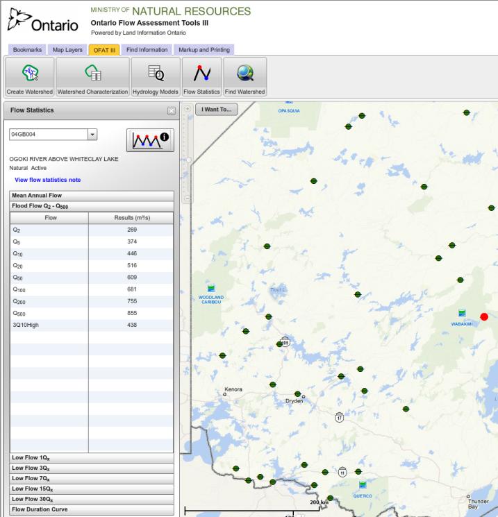
2 What is OFAT OFAT III is a free online, interactive geospatial application Users can Create watersheds Characterize watersheds Estimate watershed flow (mean annual, flood and drought condition flow) View flow monitoring (HYDAT) gauge statistics Where? Anywhere in Ontario! 2
3 Ontario Flow Assessment Tool III Produced/Hosted by: Ontario Mapping and Information Resources Branch/Spatial Data Infrastructure, Peterborough, ON Funding Support from: Ontario Far North Branch Integration Branch (Formerly Lands and Waters) MOE, Source Water Protection Lands and Resources Cluster 3

4 OFAT I & II (circa 2002, 2003) Created by automating existing, labour intensive, hydrology calculations to estimate flow regimes. OFAT did not keep up with changes and improvements to GIS software. OFAT was consistently requested by users throughout the province. MNR s Far North planning initiative highlighted the severe shortage of flow monitoring data. 4
5 Re development Based on: User community input Institute for Watershed Science User Community Survey Steering Committee (MNR, MOE, CA s) Enhancements: Available online, special software not required Overall Result: Easy access to current data 5
 Packages based on larger regional secondary (or larger) watersheds Ministry of Natural")
6 Ontario Integrated Hydrology Data Backbone of OFAT watershed creation Nine packages freely available through Land Information Ontario (LIO) Packages based on larger regional secondary (or larger) watersheds Ministry of Natural Resources 6

7 Ontario Integrated Hydrology Data Seamless, consistent Provincewide analytical hydrology for all of Ontario Specs: Stream ordered network Stream Grid Enhanced Flow Direction Grid Enforced Digital Elevation Model Lambert Conformal Conic 30 metre resolution raster data Based on 1:10k, 1:20k, 1:50k input data Ministry of Natural Resources 7


8 Functional Overview 8
 Supports economic growth (by easily providing baseline flow) Host of provincial")
9 Typical Application & Benefits Watershed based planning Baseline Flow Information (ungauged sites) Supports economic growth (by easily providing baseline flow) Host of provincial applications 9
10 Potential Enhancements Updated Spatial Data (new watersheds, base), (into Quebec, Manitoba), Monitoring HYDAT Gauges (with links), watersheds, more statistics PWQMN Gauges, watersheds Climate Characterization by watershed Precipitation Characterization Dams and Diversions Hydrology Models U of G (ANN models low flow, smaller catchments) MTO HYDAT Statistics update, current GIS data to update equations of existing regional models Geocoder, Map Cache Metadata Generation Update to HTML5 mobile enabled Suggestions?????? 10

11 OFAT as a Communication Tool Baseline Hydrology Statistics Report Pre calculated statistics for HYDAT gauges in Ontario s Far North. Watersheds delineated for each station, incorporated into report. 11


12 OFAT as a Communication Tool Surface Water Monitoring Centre Flood Event Reporting Road washout near Foleyet What was the flow rate that caused this? 12

13 OFAT as a Communication Tool Surface Water Monitoring Centre Flood Event Reporting Watershed delineated at road crossing Monitoring station identified within area Time series plotted showing sharp increase in flow 13
 Great Lakes Flood Flow (>300 gauges) in production")
14 Hydrology Statistics Streamflow: Baseline Streamflow Hydrology Complete (~50 gauges in Ontario s Far North) Summary statistics based on HYDAT gauge information Mean Annual Flow, Flood Flow, Low Flow, Flow Duration Curve In progress: RHBN gauges (Mean Annual Flow, Flood Flow, Low Flow, Flow Duration Curve) Great Lakes Flood Flow (>300 gauges) in production 14
 133 rain gauges > 10 years")
15 Hydrology Statistics Precipitation: Probable Maximum Precipitation (PMP) Estimated Probable Maximum Precipitation for 1, 6 and 24 hour rainfall using statistical method (WMO, 2009) 133 rain gauges > 10 years of record 15
16 Ministry of Natural Ministry Resources of Natural and Resources Forestry Spatial Data Infrastructure Unit.ca
Ontario Integrated Hydrology Data and OFAT III
 Ontario Integrated Hydrology Data and OFAT III Bryce Matthews, Kent Todd, Elizabeth Philip, Steve Damaia, John Gaiot, Taylor Wilkinson bryce.matthews@ontario.ca wrip@ontario.ca Latornell, November 15,
2.3 Water Budget Data In Ontario
 2.3 Water Budget Data In Ontario Water budget data available for Ontario includes meteorologic data, hydrometric data and groundwater data. Geological and physiographical data provide information to describe
Ontario Drainage Engineers Conference 21 October 2016 Guelph, Ontario
 Ontario Drainage Engineers Conference 21 October 2016 Guelph, Ontario Presented by: Hani Farghaly, PhD., P.Eng. Drainage and Hydrology Group Design and Contract Standards Office, MTO This presentation
CANADA-ONTARIO AGREEMENT (COA) RESPECTING THE GREAT LAKES BASIN ECOSYSTEM
 RESPECTING THE GREAT LAKES BASIN ECOSYSTEM") CANADA-ONTARIO AGREEMENT (COA) RESPECTING THE GREAT LAKES BASIN ECOSYSTEM GROUNDWATER SURFACE WATER MONITORING FOR CLIMATE CHANGE IN ONTARIO Phase III - Implementation Dajana Grgic, MOE A.D. LATORNELL
CANADA-ONTARIO AGREEMENT (COA) RESPECTING THE GREAT LAKES BASIN ECOSYSTEM GROUNDWATER SURFACE WATER MONITORING FOR CLIMATE CHANGE IN ONTARIO Phase III - Implementation Dajana Grgic, MOE A.D. LATORNELL
Conservation Ontario s Response to Climate Ready: Ontario s Adaptation Strategy and Action Plan June 2011
 Introduction Conservation Ontario s Response to Climate Ready: Ontario s Adaptation Strategy and Action Plan June 2011 C onservation Ontario is the network of 36 Conservation Authorities, local watershed
Rural & Agricultural Water Resource Information System in KOREA
 Rural & Agricultural Water Resource Information System in KOREA 2010. 5. JIN-HOON JO Korea Rural Community Corporation I. What is RAWRIS? Rural & Agricultural Water Resource Information System (http://rawris.ekr.or.kr)
Integrated Approach to Watershed Management for Climate Change. Charley Worte Latornell Symposium November 19, 2010
 Integrated Approach to Watershed Management for Climate Change Charley Worte Latornell Symposium November 19, 2010 Outline Implications of climate change to Ontario water resources Expert panel recommendations
Streamflow and Weather Monitoring
 Fresh water is a natural resource crucial to the economic and environmental well being of Ontario. Water supports almost all aspects of human activity including health, industrial development, and recreation.
HYDROLOGY WORKSHEET 1 PRECIPITATION
 HYDROLOGY WORKSHEET 1 PRECIPITATION A watershed is an area of land that captures rainfall and other precipitation and funnels it to a lake or stream or wetland. The area within the watershed where the
GIS Framework to Evaluate Impact of Climate Change on Water Resources
 GIS Framework to Evaluate Impact of Climate Change on Water Resources Dr. Nagraj S. Patil A. K. Gosain, Professor Civil Engineering Department I. I. T. Delhi Objectives of the Study To Develop portal to
Reservoir on the Rio Boba
 Reservoir on the Rio Boba Michael J. Burns II Guillermo Bustamante J. James Peterson Executive Summary The National Institute of Water Resources in the Dominican Republic (INDRHI) plans to construct a
CE 2031 WATER RESOURCES ENGINEERING L T P C
 CE 2031 WATER RESOURCES ENGINEERING L T P C 3 0 0 3 QUESTION BANK PART - A UNIT I GENERAL 1. Write short notes on Water Resources Survey. 2. How do you calculate Average Annual Runoff depth? 3. Write short
GIS Applications in Water Resources Engineering
 King Fahd University of Petroleum & Minerals City & Regional Planning Department Introduction to Geographic Information Systems Term Paper Presentation GIS Applications in Water Resources Engineering Prepared
Assessment of Water Monitoring Networks for Climate Change Scott MacRitchie, MOE February 9, 2011
 Assessment of Water Monitoring Networks for Climate Change Scott MacRitchie, MOE February 9, 2011 Climate Change Initiatives at GW-SW Unit, EMRB, MOE The Canada-Ontario Agreement (COA) Project: Assessment
Integrating HEC HMS generated flow hydrographs with FLO-2D. Nanda Meduri, PE, PMP, CFM Seth Lawler Venkata Dinakar Nimmala, CFM
 Integrating HEC HMS generated flow hydrographs with FLO-2D Nanda Meduri, PE, PMP, CFM Seth Lawler Venkata Dinakar Nimmala, CFM Focus of this Presentation Introduction Methodology Challenges & Solutions
Distributed Hydrological Model For An Ungauged Subcatchment
 Distributed Hydrological Model For An Ungauged Subcatchment Dr. Krishna Mohan M Professor of Civil Engineering, Malla Reddy Engg College (Autonomous under JNTUH), Secunderabad Abstract Rainfall and runoff
Current and future research for producing agricultural statistics using remote sensing and GIS technologies at Statistics Canada
 Current and future research for producing agricultural statistics using remote sensing and GIS technologies at Statistics Canada www.statcan.gc.ca Telling Canada s story in numbers Remote Sensing and Geospatial
Climate Change A Flood Management Perspective. Conservation Ontario Hamilton Workshop D. Boyd Grand River Conservation Authority
 Climate Change A Flood Management Perspective Conservation Ontario Hamilton Workshop D. Boyd Grand River Conservation Authority Outline Expected Impacts and Consequences Where CA s, local municipalities
Chapter 1 Introduction
 Engineering Hydrology Chapter 1 Introduction 2016-2017 Hydrologic Cycle Hydrologic Cycle Processes Processes Precipitation Atmospheric water Evaporation Infiltration Surface Runoff Land Surface Soil water
History Flood Management Prevention Protection Flood Warnings Emergency Preparedness and Response Flooding Flood Safety Bulletin/Advisory
 History The most severe flooding on record in Ontario occurred in October 1954 when Hurricane Hazel passed into southern Ontario. Eighty-one people died and damages were estimated at over $180 million.
ICELANDIC RIVER / WASHOW BAY CREEK INTEGRATED WATERSHED MANAGEMENT PLAN STATE OF THE WATERSHED REPORT CONTRIBUTION SURFACE WATER HYDROLOGY REPORT
 ICELANDIC RIVER / WASHOW BAY CREEK INTEGRATED WATERSHED MANAGEMENT PLAN STATE OF THE WATERSHED REPORT CONTRIBUTION SURFACE WATER HYDROLOGY REPORT Disclaimer: The hydrologic conditions presented in this
A comparative study of the methods for estimating streamflow at ungauged sites
 22nd International Congress on Modelling and Simulation, Hobart, Tasmania, Australia, 3 to 8 December 2017 mssanz.org.au/modsim2017 A comparative study of the methods for estimating streamflow at ungauged
Module 3. Lecture 6: Synthetic unit hydrograph
 Lecture 6: Synthetic unit hydrograph Synthetic Unit Hydrograph In India, only a small number of streams are gauged (i.e., stream flows due to single and multiple storms, are measured) There are many drainage
Presentation at the Woodrow Wilson International Center for Scholars Charles Lawson and Willem Brakel July 23, 2009
 Presentation at the Woodrow Wilson International Center for Scholars Charles Lawson and Willem Brakel July 23, 2009 40 percent of the border between the U.S. and Canada is water Over 300 lakes and rivers
ONTARIO LOW WATER RESPONSE
 ONTARIO LOW WATER RESPONSE Ontario Ministry of Natural Resources Ontario Ministry of the Environment Ontario Ministry of Agriculture, Food and Rural Affairs Ontario Ministry of Municipal Affairs and Housing
The Lake Simcoe Climate Change Adaptation Planning Process
 The Lake Simcoe Climate Change Adaptation Planning Process Adaptation Through Legislation Pilot Project Steering Committee Al Douglas OCC I AR Paul Gray OMNR Chris Lemieux U of Waterloo Vidya Anderson
SOUTHEAST TEXAS CONTINUING EDUCATION
 EXAM No. 118 FLOOD - RUNOFF ANALYSIS 1. Information gained from flood - runoff analysis includes which one: A. Stage, discharge, volume. B. Measure depth, volume. C. Velocity, depth, storm occurrence.
1 n. Flow direction Raster DEM. Spatial analyst slope DEM (%) slope DEM / 100 (actual slope) Flow accumulation
 slope DEM / 100 (actual slope) Flow accumulation") 1 v= R S n 2/3 1/2 DEM Flow direction Raster Spatial analyst slope DEM (%) Flow accumulation slope DEM / 100 (actual slope) 0 = no cell contributing 215 = 215 cell contributing towards that cell sqrt (actual
1 v= R S n 2/3 1/2 DEM Flow direction Raster Spatial analyst slope DEM (%) Flow accumulation slope DEM / 100 (actual slope) 0 = no cell contributing 215 = 215 cell contributing towards that cell sqrt (actual
Pasquia Area Drainage and Pumping System
 Pasquia Area Drainage and Pumping System Review of Operating Guidelines Public Open House August 22, 2017 Welcome! Manitoba Infrastructure, the Rural Municipality (RM) and The Pas and District Farmer s
FloodCast: A Framework for Enhanced Flood Event Decision Making for Transportation Resilience
 NCHRP 20-59(53) FloodCast: A Framework for Enhanced Flood Event Decision Making for Transportation Resilience April 2017 Presenters: Mat Mampara, Caroline Whitehead & Alaurah Moss (Dewberry) Project Overview
CENTRAL ASSINIBOINE INTEGRATED WATERSHED MANAGEMENT PLAN SURFACE WATER HYDROLOGY REPORT
 CENTRAL ASSINIBOINE INTEGRATED WATERSHED MANAGEMENT PLAN SURFACE WATER HYDROLOGY REPORT Planning Area Boundary: The Central Assiniboine planning area covers the reach of the Assiniboine River from just
Rapid Hydropower Assessment Model Identify Hydroelectric Sites Using Geographic Information Systems
 ABSTRACT Rapid Hydropower Assessment Model Identify Hydroelectric Sites Using Geographic Information Systems By Ron Monk, M.Eng., P.Eng.; Stefan Joyce, P.Eng.; and Mike Homenuke, P.Eng. Kerr Wood Leidal
2. Potential Extreme Peak Discharge in Texas
 2. Potential Extreme Peak Discharge in Texas This part of the work is focused on using GIS to apply the latest USGS peak discharge equations to create a 500m grid that stores the potential peak discharge
Ontario s Adaptation Strategy and Action Plan David Pearson Laurentian University 13 November 2011
 Ontario s Adaptation Strategy and Action Plan 2011 2014 David Pearson Laurentian University 13 November 2011 Climate Ready: Ontario s Adaptation Strategy and Action Plan Fall 2011 Ontario s Changing Climate
Uncertainty in Hydrologic Modelling for PMF Estimation
 Uncertainty in Hydrologic Modelling for PMF Estimation Introduction Estimation of the Probable Maximum Flood (PMF) has become a core component of the hydrotechnical design of dam structures 1. There is
PARAMETERS OF LOW FLOW AND DATA ON LOW FLOWS IN SELECTED IRISH RIVERS
 PARAMETERS OF LOW FLOW AND DATA ON LOW FLOWS IN SELECTED IRISH RIVERS, Senior Scientific Officer, Environmental Protection Agency SUMMARY Low flow conditions in Ireland are usually expressed in terms of
Flows and Levels of the Muskoka River System Living in Cottage Country
 Flows and Levels of the Muskoka River System Living in Cottage Country Presenter: Steve Taylor, Ministry of Natural Resources and Forestry Muskoka River Watershed Originates on western slopes of Algonquin
Canadian Environmental Sustainability Indicators. Water Quantity in Canadian Rivers
 Canadian Environmental Sustainability Indicators Water Quantity in Canadian Rivers Suggested citation for this document: Environment and Climate Change Canada (2016) Canadian Environmental Sustainability
R. Srinivasan, J.H. Jacobs, J.W. Stuth, J. Angerer, R. Kaithio and N. Clarke
 Impacts of reforestation policy and agro-forestry technology on the environment and food security in the Upper Tana river basin of Kenya R. Srinivasan, J.H. Jacobs, J.W. Stuth, J. Angerer, R. Kaithio and
Science supporting the Great Lakes Water Quality Agreement: Groundwater and Climate Change Information Needs and Gaps
 Science supporting the Great Lakes Water Quality Agreement: Groundwater and Climate Change Information Needs and Gaps Latornell Symposium November 19 2015 Great Lakes Water Quality Agreement Purpose: provide
Automated Unimpaired Hydrologic Metric Scaling for California Streams
 Automated Unimpaired Hydrologic Metric Scaling for California Streams Abstract The following report is the beginning of a larger study to provide unimpaired daily hydrographs for streams in the state of
Evaluation of Flood Forecasting and Warning Systems in Canada. Peter F. Rasmussen University of Manitoba
 Evaluation of Flood Forecasting and Warning Systems in Canada Peter F. Rasmussen University of Manitoba Being a flood forecaster requires thick skin! 3 4 5 Water Resources Management Divisio Department
IJSER. within the watershed during a specific period. It is constructed
 International Journal of Scientific & Engineering Research, Volume 5, Issue 7, July-014 ISSN 9-5518 306 within the watershed during a specific period. It is constructed I. INTRODUCTION In many instances,
The Impact of Wetland Drainage on the Hydrology of a Northern Prairie Watershed
 John Pomeroy, Xing Fang, Stacey Dumanski, Kevin Shook, Cherie Westbrook, Xulin Guo, Tom Brown, Adam Minke, Centre for Hydrology, University of Saskatchewan, Saskatoon, Canada The Impact of Wetland Drainage
Kemptville Creek Floodplain Mapping Estimation of Flows
 Technical Memo October 27, 2007 To: Bruce Reid, P.Eng. Director, Watershed Sciences and Engineering Services From: Ferdous Ahmed, Ph.D., P.Eng. Senior Water Resources Engineer Subject: Kemptville Creek
Alix Scarborough, Project Manager. Melissa Keen, GIS Analyst. Matthew Leach, GIS Analyst. Chad Sydow, GIS Analyst
 Alix Scarborough, Project Manager Melissa Keen, GIS Analyst Matthew Leach, GIS Analyst Chad Sydow, GIS Analyst Watershed and Tree Canopy Association in Austin, TX Project Proposal Prepared by Trees in
UNIT HYDROGRAPH AND EFFECTIVE RAINFALL S INFLUENCE OVER THE STORM RUNOFF HYDROGRAPH
 UNIT HYDROGRAPH AND EFFECTIVE RAINFALL S INFLUENCE OVER THE STORM RUNOFF HYDROGRAPH INTRODUCTION Water is a common chemical substance essential for the existence of life and exhibits many notable and unique
Latest tools and methodologies for flood modeling
 Latest tools and methodologies for flood modeling Dr. Yuri Simonov Senior scientist, Hydrometcentre of Russia WMO Commission for Hydrology AWG member Floods - background Types of water-related natural
Importance of Water Quantity on Modeling Using a Vulnerability Index for Northern Ontario Watersheds
 Importance of Water Quantity on Modeling Using a Vulnerability Index for Northern Ontario Watersheds Elizabeth Philip, Kent Todd, Steve Damaia, Paul Staples and Taylor Wilkinson Ontario Ministry of Natural
MEMORANDUM NOTE DE SERVICE
 REGIONAL MUNICIPALITY OF OTTAWA-CARLETON MUNICIPALITÉ RÉGIONALE D OTTAWA-CARLETON MEMORANDUM NOTE DE SERVICE Our File/N/Réf. 04-98-0001 Your File/V/Réf. DATE 22 June 1998 TO/DEST. FROM/EXP. SUBJECT/OBJET
Suspended Sediment Discharges in Streams
 US Army Corps of Engineers Hydrologic Engineering Center Suspended Sediment Discharges in Streams April 1969 Approved for Public Release. Distribution Unlimited. TP-19 REPORT DOCUMENTATION PAGE Form Approved
New Flood Risk Products for Flood Forecasting and Warning Systems in Colorado
 Proud Titanium Sponsor of the ASFPM 2016 Annual Conference New Flood Risk Products for Flood Forecasting and Warning Systems in Dr. Shane Parson, AECOM Thuy Patton, Water Conservation Board Remmet DeGroot,
Module 2 Measurement and Processing of Hydrologic Data
 Module 2 Measurement and Processing of Hydrologic Data 2.1 Introduction 2.1.1 Methods of Collection of Hydrologic Data 2.2 Classification of Hydrologic Data 2.2.1 Time-Oriented Data 2.2.2 Space-Oriented
APPENDIX E ESTIMATING RUNOFF FROM SMALL WATERSHEDS
 ESTIMATING RUNOFF FROM SMALL WATERSHEDS June 2011 THIS PAGE LEFT BLANK INTENTIONALLY. June 2011 TABLES Table E.1 Table E.2 Return Frequencies for Roadway Drainage Design Rational Method Values June 2011
Climate Change Adaptation in Ontario
 Climate Change Adaptation in Ontario A.D. Latornell Conservation Symposium Ministry of the Environment November 17, 2010 1 Outline Expert Panel on Climate Change Adaptation The Panel Process Overview of
Margaret Walls. RFF First Wednesday Seminar. Green Infrastructure: Using Natural Landscapes for Flood Mitigation and Water Quality Improvements
 THE ROLE OF LAND USE IN ADAPTATION TO INCREASED PRECIPITATION AND FLOODING Margaret Walls RFF First Wednesday Seminar Green Infrastructure: Using Natural Landscapes for Flood Mitigation and Water Quality
4. Present Activities and Roles
 4. Present Activities and Roles The present missions, authorities, activities and roles of the various agencies involved with flood protection, floodplain management and flood-damage reduction are identified
Policy Review of Municipal Stormwater Management in the Light of Climate Change Summary Report
 Policy Review of Municipal Stormwater Management in the Light of Climate Change Summary Report Executive Summary In response to an Application for Review submitted under the Environmental Bill of Rights,
APPLICATION OF SWAT MODEL TO THE STUDY AREA
 CHAPTER 5 APPLICATION OF SWAT MODEL TO THE STUDY 5.1 Introduction The Meenachil river basin suffers from water shortage during the six non-monsoon months of the year. The available land and water resources
AN INTEGRATED FRAMEWORK FOR EFFECTIVE ADAPTATION TO CLIMATE CHANGE IMPACTS ON WATER RESOURCES
 AN INTEGRATED FRAMEWORK FOR EFFECTIVE ADAPTATION TO CLIMATE CHANGE IMPACTS ON WATER RESOURCES A. K. Gosain, Professor & Head Civil Engineering Department Indian Institute of Technology Delhi: gosain@civil.iitd.ac.in
Runoff and geomorphic properties of North Carolina rivers
 Runoff and geomorphic properties of North Carolina rivers Michael Kanarek Dec. 7, 2012 CE 394K.3 Introduction Hypsometric analysis is used in a several geologic fields, including hydrology. A number of
Assessment of land-use change on streamflow using GIS, remote sensing and a physically-based model, SWAT
 doi:10.5194/piahs-364-38-2014 38 Evolving Water Resources Systems: Understanding, Predicting and Managing Water Society Interactions Proceedings of ICWRS2014, Bologna, Italy, June 2014 (IAHS Publ. 364,
Assessing ecological flow conditions for wetlands fed from ungauged stream reaches
 European Water 58: 119-126, 2017. 2017 E.W. Publications Assessing ecological flow conditions for wetlands fed from ungauged stream reaches A. Gül *, K. Ayyıldız, F. Barbaros and T. Baran Department of
Models Overview: Purposes and Limitations
 Models Overview: Purposes and Limitations Pollutant load originates from: Point-source discharges (NPDES facilities) Info is available on the discharges (DMRs, etc.) Some are steady-flow, others are precip-driven
JOURNAL OF APPLIED SCIENCES RESEARCH
 Copyright 2015, American-Eurasian Network for Scientific Information publisher JOURNAL OF APPLIED SCIENCES RESEARCH ISSN: 1819-544X EISSN: 1816-157X JOURNAL home page: http://www.aensiweb.com/jasr Published
MANAGING FRESHWATER INFLOWS TO ESTUARIES
 MANAGING FRESHWATER INFLOWS TO ESTUARIES The preparation of this document was made possible through support provided by the Office of Natural Resources Management, Bureau for Economic Growth, Agriculture
WMS Tools For Computing Hydrologic Modeling Parameters
 WMS Tools For Computing Hydrologic Modeling Parameters Lesson 9 9-1 Objectives Use the drainage coverage as a basis for geometric parameters as well as overlaying coverages to compute important hydrologic
International Journal of Scientific & Engineering Research, Volume 5, Issue 7, July-2014 ISSN Sruthy Nattuvetty Manoharan
 ISSN 2229-5518 210 Sruthy Nattuvetty Manoharan Department of Civil Engineering Government Engineering College, Thrissur Thrissur, 680009 sruthy.n.m@gmail.com a spatially distributed excess rainfall. It
Hydrology and Water Resources Engineering
 Hydrology and Water Resources Engineering SUB GSttingen 214 868 613 K.C. Patra 't'v Mai Narosa Publishing House New Delhi Chennai Mumbai Calcutta CONTENTS Preface vii 1. Introduction 1 1.1 General 1 1.2
Information Requirements Table for Liquid Waste
 Applicant Summary Tracking # Authorization # Applicant / Facility Name Ministry of Environment Prepared by: Title Date The Information Requirements Table (IRT) for Liquid Waste is a tool used by Ministry
Comparison of three flood runoff models in the Shonai River basin, Japan
 Comparison of three flood runoff models in the Shonai River basin, Japan TOSHIHARU KOJIMA Division of Fluvial and Marine Disasters, Disaster Prevention Research Institute, Kyoto University, Gokasho, Uji,
Lab 5: Watershed hydrology
 Lab 5: Watershed hydrology Objectives In this lab, you will learn the fundamentals of flow routing and channel network extraction, and analyze precipitation and discharge data to explore the control of
Climate Change Impacts on Water Resources in River Basins of India
 Climate Change Impacts on Water Resources in River Basins of India A. K. Gosain Professor & Head, Civil Engineering Department Indian Institute of Technology Delhi Water resource development Shall always
Alternative Approaches to Water Resource System Simulation
 US Army Corps of Engineers Hydrologic Engineering Center Alternative Approaches to Water Resource System Simulation May 1972 Approved for Public Release. Distribution Unlimited. TP-32 REPORT DOCUMENTATION
FLOW AND PRECIPITATION MONITORING
 FLOW AND PRECIPITATION MONITORING A Discussion Paper in Support of the Development of A Regional Watershed Monitoring Network Prepared By: The Toronto and Region Conservation Authority September, 2000
A Journey Down the Tuin: the Hydraulics of an Internal Draining River from the Khangai Mountains to the Gobi Desert
 Proceedings of the Trans-disciplinary Research Conference: Building Resilience of Mongolian Rangelands, Ulaanbaatar Mongolia, June 9-10, 2015 A Journey Down the Tuin: the Hydraulics of an Internal Draining
Estimation of the extreme meteorological and hydrological conditions in Slovenia in the future
 International Workshop on Climate Change, Budapest, 6 8 June 2016 REPUBLIC OF SLOVENIA MINISTRY OF THE ENVIRONMENT AND SPATIAL PLANNING SLOVENIAN ENVIRONMENT AGENCY Estimation of the extreme meteorological
Simulation of Daily Streamflow
 US Army Corps of Engineers Hydrologic Engineering Center Simulation of Daily Streamflow April 1968 Approved for Public Release. Distribution Unlimited. TP-6 REPORT DOCUMENTATION PAGE Form Approved OMB
Hydrological And Water Quality Modeling For Alternative Scenarios In A Semi-arid Catchment
 Hydrological And Water Quality Modeling For Alternative Scenarios In A Semi-arid Catchment AZIZ ABOUABDILLAH, ANTONIO LO PORTO METIER Final Conference: Brussels, Belgium-4-6 November 2009 Outline Problem
Climate and Land Use Consequences to 100-Year Flooding
 Climate and Land Use Consequences to 100-Year Flooding Presented by: Ann Scholz, PE, CPSWQ Grad Student, University of New Hampshire Robert Roseen & Thomas Ballestero, UNH Stormwater Center Michael Simpson,
Frequency Analysis of Low-Flows in the Large Karoun River Basin in Iran
 International Research Journal of Applied and Basic Sciences 2013 Available online at www.irjabs.com ISSN 2251-8X / Vol, 4 (1): 146-151 Science Explorer Publications Frequency Analysis of Low-Flows in
The Water Survey of Canada Stream and Lake Gauging Network
 The Water Survey of Canada Stream and Lake Gauging Network Past and Future Hydroclimatic Variability: Applications to Water Resource Management in the Prairie Provinces The Water Survey of Canada Stream
SECTION IV WATERSHED TECHNICAL ANALYSIS
 A. Watershed Modeling SECTION IV WATERSHED TECHNICAL ANALYSIS An initial step in the preparation of this stormwater management plan was the selection of a stormwater simulation model to be utilized. It
Assessing the Effect of Streamflow Estimation at Potential Station Locations in Entropy-Based Hydrometric Network Design
 EPiC Series in Engineering Volume 3, 2018, Pages 1048 1054 HIC 2018. 13th International Conference on Hydroinformatics Engineering Assessing the Effect of Streamflow Estimation at Potential Station Locations
Productivity Commission Draft Report on National Water Reform
 Productivity Commission Draft Report on National Water Reform Engineers Australia submission October 2017 Table of Contents 1. Introduction... 3 2. Management of Water for Public Benefit Outcomes... 3
APPENDIX E APPENDIX E ESTIMATING RUNOFF FOR SMALL WATERSHEDS
 APPENDIX E ESTIMATING RUNOFF FOR SMALL WATERSHEDS March 18, 2003 This page left blank intentionally. March 18, 2003 TABLES Table E.1 Table E.2 Return Frequencies for Roadway Drainage Design Rational Method
Rags to Riches - The RVCA Story of Science to Stewardship
 Rags to Riches - The RVCA Story of Science to Stewardship Rideau Valley Conservation Authority Eastern Ontario On Shield off Shield Large Urban population (Ottawa) Rideau Canal connecting St Lawrence to
A WEAP Model of the Kinneret Basin
 A WEAP Model of the Kinneret Basin Illy Sivan 1, Yigal Salingar 1 and Alon Rimmer 2 This is an English translation of the article that originally appeared in Sivan, I., Y. Salingar, and A. Rimmer, A WEAP
CHAPTER ONE : INTRODUCTION
 CHAPTER ONE : INTRODUCTION WHAT IS THE HYDROLOGY? The Hydrology means the science of water. It is the science that deals with the occurrence, circulation and distribution of water of the earth and earth
Assessment Watersheds for Regional Level Applications
 Assessment Watersheds for Regional Level Applications A new standard product of the 1:20 000 Freshwater Atlas February 2009 Martin Carver 1 and Malcolm Gray 2 1 A/Director, Water Protection, Health Protection
GCI Survey---Lake Winnipeg Watershed
 IISD-GWSP Conference. Winnipeg May 1-4, 2012 Water-Energy-Food Nexus GCI Survey---Lake Winnipeg Watershed A. A. WARKENTIN Hydrometeorologist GCI Survey Lake Winnipeg Watershed PRESENTATION OUTLINE WATERSHED
North Bay-Mattawa Source Protection Area Assessment Report
 North Bay-Mattawa Source Protection Area Assessment Report Updated January 17, 2014 Approved by Ministry of Environment and Climate Change February 10, 2015 Table of Contents Table of Contents... i List
FISHER RIVER INTEGRATED WATERSHED MANAGEMENT PLAN STATE OF THE WATERSHED REPORT CONTRIBUTION SURFACE WATER HYDROLOGY REPORT
 FISHER RIVER INTEGRATED WATERSHED MANAGEMENT PLAN STATE OF THE WATERSHED REPORT CONTRIBUTION SURFACE WATER HYDROLOGY REPORT Disclaimer: The hydrologic conditions presented in this report are estimates
Section 3 General Development Policies
 3.4.6 Substandard System Improvements The Municipality will actively encourage the participation of its residents in any program that the HKPRDHU or the MOE designed to upgrade or replace existing substandard
Development of a GIS Tool for Rainfall-Runoff Estimation
 Development of a GIS Tool for Rainfall-Runoff Estimation Ashraf M. Elmoustafa * M. E. Shalaby Ahmed A. Hassan A.H. El-Nahry Irrigation and Hydraulics Department, Ain Shams University, Egypt NARSS, Egypt
Modeling the Hydrologic Impacts of Control Structures Utilizing LiDAR, ICPR, and GIS Technologies
 Modeling the Hydrologic Impacts of Control Structures Utilizing LiDAR, ICPR, and GIS Technologies Keanan Bell NorthStar June 12, 2015 Project began in 2010 as a Hydrology Assessment and Conceptual Restoration
Assessing the Risk of 100-year Freshwater Floods in the Lamprey River Watershed of New Hampshire Resulting from Changes in Climate and Land Use
 Assessing the Risk of 100-year Freshwater Floods in the Lamprey River Watershed of New Hampshire Resulting from Changes in Climate and Land Use Presented by: Ann Scholz, PE, CPSWQ Advisor: Dr. Robert Roseen,
Performance Standards for Target Hydrology
 Performance Standards for Target Hydrology Steve Eggers Senior Ecologist Regulatory Branch St. Paul District December 10, 2015 US Army Corps of Engineers Introduction Target Hydrology: the hydrology necessary
COOPERATING TECHNICAL PARTNER INFORMATION EXCHANGE. First Order Approximations
 COOPERATING TECHNICAL PARTNER INFORMATION EXCHANGE First Order Approximations WELCOME ASFPM Mapping and Engineering Standards Committee CTP Sub committee Co chairs: Amanda Flegel, PE, CFM; Illinois State
Impact Study of a check dam on Ground Water Recharge
 Impact Study of a check dam on Ground Water Recharge 1 P.Arun Raja, C. Dinesh, B.Jagadeesan 1,, UG Student, Department of Civil Engineering, Mamallan Institute of Technology, Kanchipuram, INDIA Abstract: