Climate Change Impacts: Caribbean
|
|
|
- Merry Higgins
- 6 years ago
- Views:
Transcription
1 a work in progress Climate Change Impacts: watersheds of Mesoamerica and the Caribbean Water quality and availability Flood potential
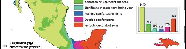
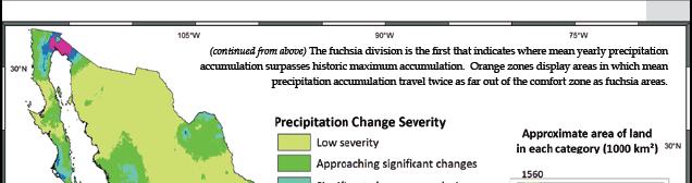
2 Context CATHALAC & SERVIR Climate Change and Biodiversity Increasing frequency and intensity in disasters Sediment and erosion modeling Land cover change Deforestation: soil loss, lack of water retention Urban and agricultural expansion: water needs up
3 CATHALAC Mission Promote integrated watershed management in Latin America and the Caribbean, by means of applied investigation, education, and technology transfer Vision A prosperous and sustainable envi- ronment in the Latin America and Caribbean region

4 CATHALAC Integrated Watershed Resource Management Climate Change Environmental Modeling and Analysis Risk Management Our International Education Programs are derived from these programs


5 the Regional Visualization & Monitoring System (SERVIR) Terra Aqua Mesoamerica s Earth Observation & Forecasting Platform Earth Observing System Data and Operations System Fire Red Tides Test-bed at NASA MSFC LandSat MODIS SRTM AMSR-E IKONOS ASTER Environmental Monitoring & Decision Support Products Operational Node at CATHALAC Panama Web Interface Users Mesoamerican & Caribbean Government agencies NGOs, Researchers Educators, etc. Thematic Areas Agriculture Biodiversity Climate Ecosystems Energy Disasters Health Water Weather Land Cover / Use Change Impacts Emergency Response Policy Changes Corridor Preservation Species Preservation Sustained Development Improved livelihoods SERVIR is a completely 5 open- access system with products in range of formats


6 Potential Impacts of Climate Change on Biodiversity in Central America, Mexico, and the Dominican Republic, CATHALAC Data derived from: NatureServe InfoNatura Species Distribution Grids. WorldClim Climate Grids: Current and Future Conditions. IUCN World Commission on Protected Areas, 2007.


7 Trend analysis Climate change is expected to increase the frequency and intensity of tropical systems
8 Case study: Panama Canal Watershed (RUSLE)


9 Local water quality Sedimentation to Runoff ratio Identification of Identification of critical areas
10 Water availability Current demand Future demand Land use change scenarios: Control Urban & agricultural growth scenario Present changing demands in the context of g g changing precipitation trends
11 Input data Elevation Precipitation Land cover Soil
12 Data - terrain GTOPO DEM, 1km Synthetic rivers and watersheds: D-8 method (Fairfield and Laymarie 1991) Why synthetic? Regional data do not always show transboundary watersheds very well and they re the important ones! Support hydrological modeling Validate with national datasets
13 Data - climate Worldclim baseline (1950s-1990s): 1km interpolated precipitation (Hijmans et al. 2005) 18 Worldclim climate change scenarios HadCM3 CGCM3T47 CSIRO Mk3 x A2 B2 x 2020s 2050s 2080s SERVIR RCM (Hernandez et al. 2006) Jan, Feb, June, July, August, September Hadley Centre Coupled Model, version 3 Canadian Centre for Climate Modelling and Analysis, Coupled Global Climate Model Commonwealth Scientific and Industrial Research Organization coupled model, Australia
14 Data - land cover and soil GlobCover, reclassified to C-CAP Cover factor Soils, FAO Erodibility (k factor) USGS hydrological group
15 Tools Spatial Analyst Hydrology tools Surface tools Others (e.g., map algebra, raster calculator) N-SPECT: Nonpoint Source Pollution and Erosion Comparison Tool (NOAA)
16 Preliminary results, per watershed 12 baseline months + annual accumulation (12 projected months + annual accum.) x 18 scenarios = 234 Anomaly per watershed, for the above Zonal Statistics Map Algebra
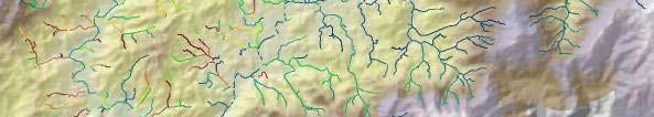
17 Monthly accumulated precipitation per watershed: baseline Light Heavy
18 Monthly accumulated precipitation per watershed: HadCM3 A2 2020s Light Heavy
19 Monthly anomaly per watershed: [HadCM3 A2 2020s] baseline Drier Wetter
20 Monthly anomaly per watershed: scenario baseline For each month, consider: HadCM3, CGCM3T47, CSIRO Mk3 A2 & B2 scenarios 2020s, 2050s, 2080s 18 x 12 = 216 monthly precipitation anomaly per watershed grids


21 Relative Precipitation Change


22 Monthly anomalies: a snapshot of capital cities in the region
23 Regional water quality Utilize N-SPECT to derive runoff and sedimentation estimates under baseline conditions and climate change scenarios Compare the ratio of sedimentation to runoff to discover rivers that are projected to experience more sedimentation than normal, given the change in precipitation patterns


24 Regional water availability TEST: Add into the mix land cover change scenarios, based on population growth and agricultural expansion trends CONTROL: Leaving land cover the same We are already familiar with land cover change cases El Valle de Anton, Panamá


25 Land use change and erosion Bosque intervenido Rastrojo Uso agro. de subsist Uso agropecuario La Indiana Dormida, Intensification of Agriculture


26 Land use change and erosion Cerro El Gaital Bosque maduro Bosque intervenido Rastrojo Uso agro. de subsist. Uso agropecuario Soil and Forest Conservation


27 Land Cover Scenarios 100% 90% 80% 70% 60% 50% 40% 30% 20% Water Bare Wetland Scrub Forest Grassland Ag Urban 10% 0% CURRENT S1_MRKT S2_POLICY S4_SUST Borrowed from Lauretta Burke World Resources Institute August, 2006
28 Expected results: regional water availability Observed trend of drier rainy season in many parts of the region Further stresses on water resources Areas of interest: t Transboundary watersheds Where the rain falls doesn t exactly show us the impacted areas Downstream analyses sometimes cross borders
29 Flood potential Runoff before and after Hurricane or storm scenarios (MUSLE) Related to regional flood risk map Low elevation coastal zones National flood risk maps Highlight currently flood prone areas that are expected to undergo change Highlight g new prone areas that weren t before


30 Flood risk Utilizing the event-based feature in N-SPECT, a normal week can be compared to a very rainy week Application of similar downstream analyses
31 Contact For more complete results, please visit or contact
CLIMATE CHANGE IMPACTS ON SURFACE WATER
 CLIMATE CHANGE IMPACTS ON SURFACE WATER Eric R. Anderson 1 Ashutosh Limaye 2 Africa I. Flores 1 Emil A. Cherrington 3 1 Department of Atmospheric Sciences, University of Alabama in Huntsville, USA 2 Marshall
LAND USE PLANNING FOR MAMMINASATA METROPOLITAN WATER AVAILABILITY, SOUTH SULAWESI, INDONESIA
 LAND USE PLANNING FOR MAMMINASATA METROPOLITAN WATER AVAILABILITY, SOUTH SULAWESI, INDONESIA Roland Alexander Barkey 1, Muh. Faisal M. 2 1 Research & Development Center for Natural Heritage, Biodiversity
Hydrologic Modeling of Watersheds Discharging Adjacent to the Mesoamerican Reef
 Hydrologic Modeling of Watersheds Discharging Adjacent to the Mesoamerican Reef Analysis Summary - December 1, 2006 By: Lauretta Burke and Zachary Sugg With analytical contributions from: Will Heyman and
Use of Earth Observation Data for Water Resources Management by the Nile Basin Initiative. - Tigernet Project
 Use of Earth Observation Data for Water Resources Management by the Nile Basin Initiative. - Tigernet Project By Milly Mbuliro GIS/ Remote Sensing Specialist Nile Basin Initiative Secretariat 25-27 March,
Rock Creek Floodplain Analysis
 Rock Creek Floodplain Analysis www.co.washington.or.us By Jon Franczyk 1996 Flood, www.co.washington.or.us 1996 Flood, www.co.washington.or.us Project Outline Project Goals Introduction Background Study
The Fourth Assessment of the Intergovernmental
 Hydrologic Characterization of the Koshi Basin and the Impact of Climate Change Luna Bharati, Pabitra Gurung and Priyantha Jayakody Luna Bharati Pabitra Gurung Priyantha Jayakody Abstract: Assessment of
13 th World Lake Conference
 13 th World Lake Conference Wuhan, China 1-55 November 2009 Ecosystem Approach to Lake Management 4 November 2009 Takehiro NAKAMURA Director UNEP International Environmental Technology Centre (IETC) 1
Issues include coverage gaps, delays, measurement continuity and consistency, data format and QC, political restrictions
 Satellite-based Estimates of Groundwater Depletion, Ph.D. Chief, Hydrological Sciences Laboratory NASA Goddard Space Flight Center Greenbelt, MD Groundwater Monitoring Inadequacy of Surface Observations
INTRODUCTION cont. INTRODUCTION. What is Impervious Surface? Implication of Impervious Surface
 Mapping Impervious Surface Changes In Watersheds In Part Of South Eastern Region Of Nigeria Using Landsat Data By F. I. Okeke Department of Geoinformatics and Surveying, University of Nigeria, Enugu Campus
Mapping global soil Carbon stocks and sequestration potential
 Mapping global soil Carbon stocks and sequestration potential John Latham Renato Cumani UN/FAO Environmental Assessment and Monitoring Unit FAO, Rome, April 16, 2009 1 Food and Agriculture Organization
Ecosystem Services: Provision, Value & Policy. Steve Polasky University of Minnesota & Natural Capital Project
 Ecosystem Services: Provision, Value & Policy Steve Polasky University of Minnesota & Natural Capital Project Introduction Ecosystems provide a wide array of goods and services of value to people Human
Remotely-Sensed Fire Danger Rating System to Support Forest/Land Fire Management in Indonesia
 Remotely-Sensed Fire Danger Rating System to Support Forest/Land Fire Management in Indonesia Orbita Roswintiarti Indonesian National Institute of Aeronautics and Space (LAPAN) SE Asia Regional Research
Climate Change in Myanmar Process and Prioritizing Adaptation at the Local Level
 National Adaption Plan 2017 Asia Expo JW Marriott Dongdaemun Square Seoul, Korea September 11 12, Climate Change in Myanmar Process and Prioritizing Adaptation at the Local Level Min Maw Director, Pollution
Flood risk management and land use planning in changing climate conditions Mikko Huokuna Finnish Environment Institute, SYKE
 10th International Drainage Workshop of ICID 06.-11. July 2008 Flood risk management and land use planning in changing climate conditions Mikko Huokuna Finnish Environment Institute, SYKE Background hydrological
Identification of priority areas in the water. resource management of the watershed of the. La Villa River in Panama
 Identification of priority areas in the water resource management of the watershed of the La Villa River in Panama Kati Wenzel and Kim Gaulthier-Schampaert ENVR 451: Research in Panama 25. 04. 2008 1 CATHALAC
M.L. Kavvas, Z. Q. Chen, M. Anderson, L. Liang, N. Ohara Hydrologic Research Laboratory, Civil and Environmental Engineering, UC Davis
 Assessment of the Restoration Activities on Water Balance and Water Quality at Last Chance Creek Watershed Using Watershed Environmental Hydrology (WEHY) Model M.L. Kavvas, Z. Q. Chen, M. Anderson, L.
NATIONAL AND REGIONAL IMPACTS OF CLIMATE CHANGE ON THE INDIAN ECONOMY
 NATIONAL AND REGIONAL IMPACTS OF CLIMATE CHANGE ON THE INDIAN ECONOMY PARTHA SEN and SHREEKANT GUPTA Delhi School of Economics University of Delhi sgupta@econdse.org Climate Change and Developing Countries
1.6 Influence of Human Activities and Land use Changes on Hydrologic Cycle
 1.6 Influence of Human Activities and Land use Changes on Hydrologic Cycle Watersheds are subjected to many types of changes, major or minor, for various reasons. Some of these are natural changes and
CLIMATE CHANGE ADAPTATION PLAN OF BEN TRE PROVINCE
 30. C l i m a t e C h a n g e A d a p t a t i o n P l a n o f B e n T r e P r o v i n c e PRESENTATION CLIMATE CHANGE ADAPTATION PLAN OF BEN TRE PROVINCE November 09 Mr. Truong Duy Hai Ben Tre DONRE TOPOGRAPHY
Dang Thi Tuoi Biodiversity Conservation Agency (BCA) Ministry of Natural Resources and Environment of Vietnam (MONRE)
 Ministry of Natural Resources and Environment of Vietnam (MONRE)") Dang Thi Tuoi Biodiversity Conservation Agency (BCA) Ministry of Natural Resources and Environment of Vietnam (MONRE) Main Contents: 1. Roles of biodiversity in Vietnam 2. Threats to biodiversity in Vietnam
Dang Thi Tuoi Biodiversity Conservation Agency (BCA) Ministry of Natural Resources and Environment of Vietnam (MONRE) Main Contents: 1. Roles of biodiversity in Vietnam 2. Threats to biodiversity in Vietnam
Overview of the Surface Hydrology of Hawai i Watersheds. Ali Fares Associate Professor of Hydrology NREM-CTAHR
 Overview of the Surface Hydrology of Hawai i Watersheds Ali Fares Associate Professor of Hydrology NREM-CTAHR 5/23/2008 Watershed Hydrology Lab 1 What is Hydrology? Hydrology is the water science that
Application of SWAT Model in land-use. change in the Nile River Basin: A Review
 Application of SWAT Model in land-use change in the Nile River Basin: A Review By: Marwa Ali, Okke Batelaan and Willy Bauwens 15-6-2011 Application of SWAT Model in land-use 1 change in the Nile River
CLIMATE INFORMATION IN HAZARD RISK ASSESSMENT JANNEKE ETTEMA, VICTOR JETTEN, DINAND ALKEMA, THEA TURKINGTON
 CLIMATE INFORMATION IN HAZARD RISK ASSESSMENT JANNEKE ETTEMA, VICTOR JETTEN, DINAND ALKEMA, THEA TURKINGTON FIRE ENSCHEDE - YESTERDAY On fire ~100 m ITC building Short rain event made the wind direction
Training Course Brochure Building Capacity in Rural & Urban Water Management
 Training Course Brochure 2015 Building Capacity in Rural & Urban Water Management Introduction The WastePro Academy seeks to encourage the use of desktop software applications in the water and environmental
Chehalis Basin Strategy Causes of Extreme Flooding. October 11, 2016 Policy Workshop
 Chehalis Basin Strategy Causes of Extreme Flooding October 11, 2016 Policy Workshop Agenda Hydrology o Precipitation o Flow Climate Change Effects Land Use o Channel straightening and incision o Riparian
Assessment of Future Flow of Hatirjheel- Begunbari Drainage System due to Climate Change
 Journal of Modern Science and Technology Vol. 3. No. 1. March 2015 Issue. Pp.102-116 Assessment of Future Flow of Hatirjheel- Begunbari Drainage System due to Climate Change Sadia Afrin 1, Md. Maksimul
Major atmospheric emissions from peat fires in SEA during non-drought years: Evidence from the 2013 Sumatran fires David Gaveau
 SOCP/YEL Paul Hilton/SOCP/YEL Reuters Major atmospheric emissions from peat fires in SEA during non-drought years: Evidence from the 2013 Sumatran fires David Gaveau Salim MA, Hergoualc h K, Locatelli
Note that the Server provides ArcGIS9 applications with Spatial Analyst and 3D Analyst extensions and ArcHydro tools.
 Remote Software This document briefly presents the hydrological and hydraulic modeling software available on the University of Nice Server with Remote Desktop Connection. Note that the Server provides
Climate-Informed Water Resources in the Southeast United States. Rachel M. Gregg June 2015
 Climate-Informed Water Resources in the Southeast United States Rachel M. Gregg June 2015 Responding to Climate Change Mitigation is what we do to decrease the potential of climate change itself. Adaptation
Long-Term Agro-Ecosystem Research Network University of Wisconsin-Platteville Pioneer Farm Research
 Long-Term Agro-Ecosystem Research Network University of Wisconsin-Platteville Pioneer Farm Research Dennis L. Busch & Andrew D. Cartmill Agricultural Production in 2050: The challenges Population growth
Climate Change, Precipitation Trends and Water Quality David S. Liebl
 Climate Change, Precipitation Trends and Water Quality David S. Liebl Wisconsin Lakes Partnership Convention Stevens Point 4/25/14 Map - Kate Barrett Wisconsin Precipitation Trends: 1950-2006 Annual Summer
STORMWATER RUNOFF MODELING IMPACTS OF URBANIZATION AND CLIMATE CHANGE
 STORMWATER RUNOFF MODELING IMPACTS OF URBANIZATION AND CLIMATE CHANGE Anne Blair,* Denise Sanger, A. Frederick Holland, David White, Lisa Vandiver, Susan White Development pressure throughout the coastal
INTRODUCTION. STEP M Executive Summary 1
 INTRODUCTION Global migration is a long-standing behavioral trait of humankind that has shaped our existing and ever-changing population distribution. As the global population has increased seven-fold
NOAA S NATIONAL WATER CENTER
 NOAA S NATIONAL WATER CENTER Informing Decisions for a Water-Prepared Nation Tom Graziano, Ph.D. Acting Director, National Water Center National Weather Service, NOAA 1 Outline Stakeholder Priorities NWC
ENVIRONMENTAL OUTLOOK TO 2050: The consequences of Inaction
 Km3 ENVIRONMENTAL OUTLOOK TO 25: The consequences of Inaction Key Findings on Water Around the world, cities, farmers, industries, energy suppliers, and ecosystems are increasingly competing for their
WATER RESOURCES MANAGEMENT IN THE DANUBE RIVER BASIN. Prof. Dr. Laszlo Vermes
 WATER RESOURCES MANAGEMENT IN THE DANUBE RIVER BASIN Prof. Dr. Laszlo Vermes The Danube is one of the greatest rivers in the World second biggest in Europe (after the Volga) Total length: 2842 km watershed
Meeting Plan. GEO Water Cycle Capacity Building Workshop 30 November to 4 December 2009, Lima, Peru
 Sep 10, 2009 Meeting Plan GEO Water Cycle Capacity Building Workshop 30 November to 4 December 2009, Lima, Peru This Planning Document for the Lima Peru provides information in three specific areas, namely:
VIDEO: Riparian Forest Buffers: The Link Between Land & Water
 VIDEO: Riparian Forest Buffers: The Link Between Land & Water Introduction to Riparian Buffers Adapted from: Riparian Forest Buffers: The Link Between Land & Water. Maryland Cooperative Extension. Wye
FACTSHEET INTRODUCTION. help rebalance the water cycle, mitigate the effects of climate change and improve human health and livelihoods.
 1 FACTSHEET INTRODUCTION World Water Day, on 22 March every year, is about focusing attention on the importance of water. This year s theme, Nature for Water, explores nature-based solutions (NBS) to the
IMPACT ASSESSMENT DUE TO GLOBAL CHANGE IN A COLOMBIAN ANDEAN BASIN
 IMPACT ASSESSMENT DUE TO GLOBAL CHANGE IN A COLOMBIAN ANDEAN BASIN Ocampo O.L. 1-2, Vélez J.J. 1 and Londoño A 1 1 Universidad Nacional de Colombia Sede Manizales. Instituto Estudios Ambientales IDEA.
Iowa Climate Change Adaptation and Resilience: Applying Climate Data to Plans & Ordinances
 Iowa Climate Change Adaptation and Resilience: Applying Climate Data to Plans & Ordinances Christopher J. Anderson, PhD Assistant Director, Climate Science Program Iowa State University Integrating Hazard
Alternative Futures for the City of La Paz, Mexico
 O N T H E G R O U N D Alternative Futures for the City of La Paz, Mexico Caroline Dragoo University of Arizona and Robert Faris Harvard University La Paz, Mexico is working hard not to turn into Cabo San
Delta Alliance First International Advisory Board Meeting Side Event,, COP 15, Copenhagen, 16 December 2009
 Delta Alliance First International Advisory Board Meeting Side Event,, COP 15, Copenhagen, * With contributions of Dr. Heru Santoso (CIFOR) 2 1 Delta Alliance Indonesia Wing Posture of some of Indonesia
Alternative Approaches to Water Resource System Simulation
 US Army Corps of Engineers Hydrologic Engineering Center Alternative Approaches to Water Resource System Simulation May 1972 Approved for Public Release. Distribution Unlimited. TP-32 REPORT DOCUMENTATION
Suspended Sediment Discharges in Streams
 US Army Corps of Engineers Hydrologic Engineering Center Suspended Sediment Discharges in Streams April 1969 Approved for Public Release. Distribution Unlimited. TP-19 REPORT DOCUMENTATION PAGE Form Approved
Susan P. Abano Engineer IV Policy and Program Division
 National Water Resources Board Integrated Water Resources Management Susan P. Abano Engineer IV Policy and Program Division National Water Resources Board Outline Philippines Water Resources Situationer
Towards a European Forest Fire Simulator
 Towards a European Forest Fire Simulator J.M. Baetens Research Unit Knowledge-based Systems Ghent University COST Green Engineering Camp July 2, 2012 KERMIT J.M. Baetens (KERMIT) A European Forest Fire
TRANSBOUNDARY ENVIRONMENTAL CHALLENGES IN THE VOLTA BASIN
 2 nd Workshop: River Basin Commissions and Other Joint Bodies for Transboundary Water Cooperation - Geneva, 09-10 April 2014 TRANSBOUNDARY ENVIRONMENTAL CHALLENGES IN THE VOLTA BASIN Charles Biney Ag.
AGRO-CLIMATIC PLANNING AND INFORMATION BANK (APIB) FOR UTTARAKHAND STATE, INDIA
 FOR UTTARAKHAND STATE, INDIA") AGRO-CLIMATIC PLANNING AND INFORMATION BANK (APIB) FOR UTTARAKHAND STATE, INDIA V.Madhava Rao a*, Om Prakash b, Anand Sharma b, R R Hermon a, P Kesava Rao a, N S R Prasad a, T Phanidra Kumar a, S S R S
AGRO-CLIMATIC PLANNING AND INFORMATION BANK (APIB) FOR UTTARAKHAND STATE, INDIA V.Madhava Rao a*, Om Prakash b, Anand Sharma b, R R Hermon a, P Kesava Rao a, N S R Prasad a, T Phanidra Kumar a, S S R S
Overview of Methodology Sheets for Freshwater, Coastal and Marine Resources, and Natural Disasters
 Overview of Methodology Sheets for Freshwater, Coastal and Marine Resources, and Natural Disasters United Nations Statistics Division ECOWAS Workshop on Environment Statistics (Accra, 29-31 March 2010)
History of Model Development at Temple, Texas. J. R. Williams and J. G. Arnold
 History of Model Development at Temple, Texas J. R. Williams and J. G. Arnold INTRODUCTION Then Model development at Temple A long history (1937-present) Many scientists participating in: Data collection
A global perspective on land use and cover change
 A global perspective on land use and cover change Alan Belward The Global Environment Monitoring Unit Institute for Environment and Sustainability European Commission Joint Research Centre 21027 Ispra
Climate Change, Human Activities, and the State of New Jersey. Michael J. Kennish Institute of Marine and Coastal Sciences Rutgers University
 Climate Change, Human Activities, and the State of New Jersey Michael J. Kennish Institute of Marine and Coastal Sciences Rutgers University New Jersey Climate and Environmental Change Conclusions from
(1) Bridge, Road and Railway (Adaptation Project) (2) Bridge, Road and Railway (BAU Development with Adaptation Options)
 Bridge, Road and Railway (Adaptation Project) (2) Bridge, Road and Railway (BAU Development with Adaptation Options)") Sub-sector Guideline: (1) Bridge, Road and Railway (Adaptation Project) (2) Bridge, Road and Railway (BAU Development with Adaptation Options) Basic Concept A. General Concept Climate change will increase
Sub-sector Guideline: (1) Bridge, Road and Railway (Adaptation Project) (2) Bridge, Road and Railway (BAU Development with Adaptation Options) Basic Concept A. General Concept Climate change will increase
SICMED Continental Surfaces and Interfaces in the Mediterranean area. A collaborative research project on Mediterranean anthropo-ecosystems
 SICMED Continental Surfaces and Interfaces in the Mediterranean area A collaborative research project on Mediterranean anthropo-ecosystems Scientific objectives Studying changes in Mediterranean continental
WBCSD Water Tools. Joppe Cramwinckel. CEFIC, Brussel, 12 November
 WBCSD Water Tools Joppe Cramwinckel CEFIC, Brussel, 12 November The Water Challenges Billions of people lack access to safe drinking water, sanitation and energy while climate change and growing demands
The Water-Climate Nexus and Food Security in the Americas. Michael Clegg University of California, Irvine
 The Water-Climate Nexus and Food Security in the Americas Michael Clegg University of California, Irvine The Global Challenge Global population is projected to increase by about 30% between now and 2050
global science solutions
 global science solutions Tim Martin: Riverside Technology, inc. Fort Collins, Colorado, USA 2.4: Water Security Information and Tools to Support Global Water Security International Symposium on Synergistic
Name of project: Climate Adaptation for Biodiversity, Ecosystem Services and Livelihoods in Rural Madagascar
 Name of project: Climate Adaptation for Biodiversity, Ecosystem Services and Livelihoods in Rural Madagascar Overall objectives: Assist Madagascar to improve its understanding and assessment of the impacts
Mission. Selected Accomplishments from Walnut Gulch. Facilities. To develop knowledge and technology to conserve water and soil in semi-arid lands
 USDA-ARS Southwest Watershed Research Center Mission Sound Science for Watershed Decisions To develop knowledge and technology to conserve water and soil in semi-arid lands ARS Watershed Locations Selected
ADVANCED APPLICATIONS OF HEC-HMS
 Hydrologic Engineering Center Training Course on ADVANCED APPLICATIONS OF HEC-HMS 18 22 April 2016 Davis, California Course Objectives The course covers a variety of areas that go beyond the Basic HEC-HMS
PRIORITY AXIS 1: A well connected region
 PRIORITY AXIS 1: A well connected region Corresponds to Thematic objective 7- promoting sustainable transport and removing bottlenecks in key network infrastructures All data presented is published for
USING ARCSWAT TO EVALUATE EFFECTS OF LAND USE CHANGE ON WATER QUALITY. Adam Gold Geog 591
 USING ARCSWAT TO EVALUATE EFFECTS OF LAND USE CHANGE ON WATER QUALITY Adam Gold Geog 591 Introduction The Soil and Water Assessment Tool (SWAT) is a hydrologic transport model with an objective to predict
Appendix 12. Pollutant Load Estimates and Reductions
 Appendix 12. Pollutant Load Estimates and Reductions A pollutant loading is a quantifiable amount of pollution that is being delivered to a water body. Pollutant load reductions can be calculated based
Bay of Fundy: Tides and Sea Level Rise SC 211, June 2, Gary Oberts
 Bay of Fundy: Tides and Sea Level Rise SC 211, June 2, 2015 - Gary Oberts 1. 2. 3. 4. Causes of Sea Level Rise* Warming expands water (~50%) Glacier/ice sheet melt (~50%) 1947 2009 Wilkins Ice Shelf, Antarctica
A Risky Climate for Southern African Hydro: Assessing hydrological risks and consequences for Zambezi River Basin dams
 A Risky Climate for Southern African Hydro: Assessing hydrological risks and consequences for Zambezi River Basin dams Executive summary Africa is highly vulnerable to the impacts of climate change. Numerous
Assessment of Changes in Hydrologic Regime of the Teesta River by Teesta V Hydroelectric Power Project in Sikkim India
 Assessment of Changes in Hydrologic Regime of the Teesta River by Teesta V Hydroelectric Power Project in Sikkim India Kausila Timsina Department of Geography Sikkim University INTRODUCTION Dams as monuments
Climate Change and Agriculture
 Climate Change and Agriculture Martin Parry and Cynthia Rosenzweig Intergovernmental Panel on Climate Change (U.K. Meteorological Office and Goddard Institute for Space Studies) OUTLINE What we currently
Drought vulnerability and Risk Assessment
 Capacity Development to Support National Drought Management Policies Drought vulnerability and Risk Assessment Heitor Matallo Programme officer for Latin America and the Caribbean United Nations Convention
PREDICTION OF FLOW DURATION CURVES FOR USE IN HYDROPOWER ANALYSIS AT UNGAGED SITES IN POHNPEI, FSM
 PREDICTION OF FLOW DURATION CURVES FOR USE IN HYDROPOWER ANALYSIS AT UNGAGED SITES IN POHNPEI, FSM By Dr. Leroy F. Heitz P.E. Dr. Shahram Khosrowpanah P.E. Technical Report No. 129 July 2010 PREDICTION
Modeling Climate Change Impact in the Geba Basin, Ethiopia
 2012 International Conference on Environmental, Biomedical and Biotechnology IPCBEE vol.41 (2012) (2012) IACSIT Press, Singapore Modeling Climate Change Impact in the Geba Basin, Ethiopia Haddush Goitom
SOUTHERN INDIANA 2008 FLOODS: DAMAGE ASSESSMENT AND WEB MAPPING
 SOUTHERN INDIANA 2008 FLOODS: DAMAGE ASSESSMENT AND WEB MAPPING Ejaz Hussain KyoHyouk kkim Jie Shan, Associate Professor {ehussain,kim458,jshan}@,j purdue.edu Tel:765-494-2168 School Of Civil Engineering
Causes of Sea Level Rise*
 1. 2. 3. 4. Causes of Sea Level Rise* Warming expands water (~50%) Glacier/ice sheet melt (~50%) 1947 2009 Wilkins Ice Shelf, Antarctica South Cascade Glacier, WA 1960 and 2004 (NAS, 2008) *Percentages
The newly updated and comprehensive SWMP shall:
 RFQ SCOPE OF SERVICES 2.1 Project Purpose The City of Miami, ( City ) is seeking professional engineering services from a qualified firm for the purpose of planning and developing a newly updated and comprehensive
Drought Situations and Management in Vietnam
 Drought Situations and Management in Vietnam Background: In Vietnam, drought is one of the most frequent natural disasters, only after flood and storm, and has been becoming more severe due to the impact
International Union for Conservation of Nature. Conserving biodiversity Pioneering nature s solutions to global challenges
 International Union for Conservation of Nature Conserving biodiversity Pioneering nature s solutions to global challenges WHO WE ARE Founded in 1948, IUCN is the world s largest global environmental organization.
Introduction to International Forestry Issues, Institutions and Prospects
 Introduction to International Forestry Issues, Institutions and Prospects FRST 100, October 2017 Dr. Hosny El-Lakany 5-Oct-17 1 Global Forestry Perspectives I. Why study International Forestry? II. State
THE JOINT ECONOMIC CONSEQUENCES OF CLIMATE CHANGE AND AIR POLLUTION. Rob Dellink Environment Directorate, OECD
 THE JOINT ECONOMIC CONSEQUENCES OF CLIMATE CHANGE AND AIR POLLUTION Rob Dellink Environment Directorate, OECD Impacts conference 2017 Climate change and air pollution Joint analysis of climate change and
Wetland Restoration and Floodplain Management
 Association of State Floodplain Managers Annual Conference 2016 Wetland Restoration and Floodplain Management M a k i n g t h e C a s e f o r I n t e g r a t i o n Marla J. Stelk, Policy Analyst Association
Climate Adaptation: The Role of Natural Infrastructure in Sustainable Development. September 22, 2011
 Climate Adaptation: The Role of Natural Infrastructure in Sustainable Development September 22, 2011 Ecosystem-Based Approaches to Climate Change Adaptation: A Global Assessment Dave Hole, Director, Conservation
LAND AND WATER - EARTH OBSERVATION INFORMATICS FSP
 Earth Observation for Water Resources Management Arnold Dekker,Juan P Guerschman, Randall Donohue, Tom Van Niel, Luigi Renzullo,, Tim Malthus, Tim McVicar and Albert Van Dijk LAND AND WATER - EARTH OBSERVATION
By Gerald Urquhart, Walter Chomentowski, David Skole, and Chris Barber
 By Gerald Urquhart, Walter Chomentowski, David Skole, and Chris Barber The clearing of tropical forests across the Earth has been occurring on a large scale basis for many centuries. This process, known
User Awareness & Training: LAND. Tallinn, Estonia 9 th / 10 th April 2014 GAF AG
 User Awareness & Training: LAND Tallinn, Estonia 9 th / 10 th April 2014 GAF AG Day 2 - Contents LAND (1) General Introduction to EO and the COPERNICUS Sentinel Programme Overview of COPERNICUS/GMES LAND
National Adaptation Planning for Agriculture sectors
 National Adaptation Planning for Agriculture sectors UNFCCC LEG Regional Training Workshop National Adaptation Plans (NAPs) for Asian Countries Yangon, Myanmar, 10-14 August 2015 Alessandro Spairani, FAO
Scenario Narratives Case Study: KBNERR
 Scenario Narratives Case Study: KBNERR Each of the following 4 scenario narratives was developed through one on one informational interviews with local leaders and researchers through the KBNERR Coastal
Selection of Protected Areas within the Savegre River Watershed in Costa Rica: Landscape Planning Implications for Transboundary Protection
 Selection of Protected Areas within the Savegre River Watershed in Costa Rica: Landscape Planning Implications for Transboundary Protection Kathleen Marie Fernandes 3-253 Daly Avenue, Otawa, ON K1N 6G3
Laos Country Report on Environmental Management in the Lao PDR Mining Sector. International Conference A Greater Mekong?
 Lao People s Democratic Republic Peace Independence Democracy Unity Prosperity Laos Country Report on Environmental Management in the Lao PDR Mining Sector International Conference A Greater Mekong? Poverty,
GENERAL INTRODUCTION TO WP6. The story so far. WP 6 Workshop Cheikh Anta Diop University Dakar, Senegal 6-15 June 2011
 GENERAL INTRODUCTION TO WP6 The story so far WP 6 Workshop Cheikh Anta Diop University Dakar, Senegal 6-15 June 2011 AGENDA 1. Overview of the ClimAfrica project and WP 6 2. Work so far. Selection of the
Integrated Modeling: ENVISION
 Integrated Modeling: ENVISION Cimarron River Watershed Gehendra Kharel Oklahoma State University Cimarron River Watershed Research and Extension Symposium November 17, 2016 1 Research, Data Archiving,
Geomorphologic Condition and Shallow Aquifers
 Geomorphologic Condition and Shallow Aquifers Shann Stringer Center for Ecological Sciences Geomorphology Fluvial geomorphology is the study of the physics of water, sediment, riparian area, and floodplain
Welcome to a Webinar on the National Oceanic and Atmospheric Administration. Silver Jackets Webinar Series Partnering Opportunities No.
 Welcome to a Webinar on the National Oceanic and Atmospheric Administration Silver Jackets Webinar Series Partnering Opportunities No. 4 May 31, 2017 Peter Colohan Director of Service Innovation and Partnership
Hydrological Feedbacks in Tropical African Wetlands
 Hydrological Feedbacks in Tropical African Wetlands Simon Dadson University of Oxford (simon.dadson@ouce.ox.ac.uk) Key challenges Linking across scales: can we predict the hydrological response to climate
ISET-International Discussion Paper. Regional Integration in the Mekong: Challenges of Urbanization and Climate Change
 ISET-International Discussion Paper Regional Integration in the Mekong: Challenges of Urbanization and Climate Change ISET-International Discussion Paper Regional Integration in the Mekong: Challenges
Modelling sustainable grazing land management Relevant research in Agriculture and Global Change Programme
 Modelling sustainable grazing land management Relevant research in Agriculture and Global Change Programme Ben Henderson & Mario Herrero 20 July 2015 AGRICULTURE AND GLOBAL CHANGE / AGRICULTURE FLAGSHIP
GIS Applications in Water Resources Engineering
 King Fahd University of Petroleum & Minerals City & Regional Planning Department Introduction to Geographic Information Systems Term Paper Presentation GIS Applications in Water Resources Engineering Prepared
Vulnerabilities to Climate Change Impacts and Strengthening Disaster Risk Management in East Asian Cities
 Hanoi, Vietnam 2008 Primer Reducing Vulnerabilities to Climate Change Impacts and Strengthening Disaster Risk Management in East Asian Cities I/ CITY DESCRIPTION A. Hanoi Topography and demography characteristics
Climate Change, Food and Water Security in Bangladesh
 12 29 March 2016 Climate Change, Food and Water Security in Bangladesh Haweya Ismail Research Analyst Global Food and Water Crises Research Programme Key Points Bangladesh s geographical location, poverty