Windfarm Impacts on South Galway Flooding
|
|
|
- Erica Casey
- 6 years ago
- Views:
Transcription
1 Windfarm Impacts on South Galway Flooding Letter of Complaint to ESB 7 th April 2017 South Galway Flood Relief Committee Overview South Galway over the past 20 years has suffered a number of severe flooding events that have brought many communities into severe crisis. The area of South Galway has unique hydrological characteristics in that waters draining from the Slieve Aughty Mountains must travel several times underground on the journey to the sea. These underground channels are fixed capacity so any changes to natural hydrology that increase peak flows can cause severe flooding in the Slieve Aughty lower catchment. There are several key stakeholders in the Slieve Aughty mountain land management and there are key concerns that past and current land management practices have affected the mountain hydrology substantially and water is flowing off the mountain much quicker than before. South Galway with its unique geology and drainage has many Special Areas of Conservation (SACs) and Specially Protected Areas (SPAs) that are protected by the EU Habitats directive. There are also Water Framework Directives and EU Flood Directives which aim to ensure that Water quality and quantity is managed and controlled through river basin management. It is our understanding that the European Court of Justice issued a ruling against Ireland in 2008 regarding on the Derrybrien windfarm construction as relevant Environmental Impact Assessments had not being carried out prior to construction. While we have seen the devastation caused by heavy rain and landslides in October 2003 and subsequent pollution of rivers and Lough Cutra, we feel that there have also been fundamental changes to the hydrology of the land occupied by the windfarm and that this has substantially increased flooding risk for the lower catchment. We are aware the current European Court of Justice ruling against Ireland in 2008, regarding the Derrybrien Windfarm and understand that the Irish authorities agreed to undertake an EIA to look in detail at further potential issues. We request as part of the addressing of this ruling that you include the longer term hydrology changes and impacts to the lower catchment as part of a retrospective EIA along with proposed mitigation measures. Note : Many of these areas are now designated SACs We welcome more recent EIAs of windfarm developments such as the Doughill Forest Property that includes windfarm drainage management plans that included design and control elements to control flow velocities and peak flow volumes. We formally request that any future windfarm developments be suspended pending a full and inclusive environmental impact assessment on the relevant river basins and local communities.

. Many of these areas have Turloughs (Most are SACs) that can swell in normal winters.")
2 South Galway Profile From a South Galway perspective, the Slieve Aughty Mountains are the source of 3 primary rivers that flow westwards toward the sea at Kinvara. These are the Ownshree, Boleyneendorish and the Owendalulleegh rivers as shown in the diagram. The most unique feature of this landscape is that the rock changes from sandstone to limestone and many of the rivers flow underground (highlighted in dotted green here). Many of these areas have Turloughs (Most are SACs) that can swell in normal winters. The following diagram describes the profile of the Owenshree River to the sea which may go underground 6 times during its course to the sea.
3 There is one simple fact for the underground river channels - They have a limited capacity for water drainage. Some swallow holes (where water sinks) in the catchment are only 1 ft square and this can only sink water at a certain rate. Water flow rates also depend on Turlough levels as water pressures rises and drops across the underground network. This makes the whole South Galway area extremely sensitive to change in hydrological dynamics (Hydromorphological changes) of the Slieve Aughty Mountains. There are many potential impacts: Increased rate of water of water coming off the mountains will causing flash flooding in areas around the immediate vicinity such as Castledaly, BlackRock, Skehana, Ballylee, Castletown and Beagh. The swallow-holes simply cannot manage large peak flows efficiently Any overall increase in volume of water descending the mountain due to changes in water storage capability in the Slieve Aughty Mountains. Also, the impact of effects of climate change (e.g. increased rainfall) may be exacerbated by hydromorphological changes from poor land management associated with windfarm development. While these impacts are felt keenly by the local communities being subject to severe flooding, the impacts will also threaten the conservation Objectives of a large number of SACs which are protected under the EU Habitats directive. Water Directive Framework The Irish Water Framework Directive, Western River Basin District, Programme of Measures and Standards For Forest and Water gives an overview of potential pressures on water from forests and forest activities together with the pathways and possible receptors involved. It highlights that forests may give rise to negative pressure on aquatic ecosystems but that proper forestry management can deliver programmes of measures with positive benefits. Section 4.7 introduces potential pressures from Hydromorphological Change. It states that; Where forests are established in the catchment area of water abstractions or water dependent habitats and species potential impacts on the water resource may occur both with reduced flow levels and reduced water table and also through washout with increased and more rapid flood peak height. It indicates that there may be hydrological changes due to site preparation, clear-felling. In particular to clear-felling it states that there can be substantial increases in hydraulic flow (e.g. 15%) which can give rise to can give rise to stream surge resulting in physical (hydro-morphological) impacts in receiving streams leading to bank erosion and stream widening. The pressure potential may be more pronounced for older forest stands which are clear-felled due to the absence of buffer zones and drainage networks extending into the aquatic zone. There are similar pressures from windfarm developments which include the above deforestation but also include wind turbine base construction, land drainage and roads.


4 It is estimated that during the Derrybrien windfarm development 200 Hectares of forest was clear-felled Over 17km of roads were contsrtructed 71 turbine bases were constructed Over 30 km of drains were dug It is clearly obvious that the Derrybrien windfarm construction had a massive affect on the hydrology as after heavy rains in 2003, a significant landslide occured in the area. This significant hydromorphological change to the land however not just a short-term issue but to this day it remains a key concern for the local communities. The changes in the Slieve Aughty mountain hydrology has been highlighted by local communities as rapidly changing over the past 20 years. The impact that this has on an area with unique karst geology with multiple underground rivers has never been researched or studied and therefore it is impossible to state that there is no impact of these hydromorphological changes.


5 South Galway Situation South Galway over the past number of years has suffered a number of severe flooding events that have brought many communities into severe crisis. Winter 2009, Spring 2014, and Winter 2015 were the more recent flooding events. Flooding 2009 Areas all the way from Beagh to Kinvara suffered severe flooding. Farmer in Beagh, downstream from the windfarm. He claims the water is coming off straight off the mountains, compared to what happened in the past. In 2009, Gort river could not sink enough water through the swallow hole at Castletown and this backed-up into Gort causing severe flooding. The source of this rivers is the Owendallaugh river that flows into Beagh and Gort is sourced in the Slieve Aughty mountains. Flooding in Crowe St, Gort Town Flooding across the N18 close to Kiltartan, downstream of Gort. This is not a river path, this is a flooding overflow.


6 The heavy silting of a Kiltartan River after 2009 flooding. There is normally no visible silting in this river but postflooding there was 5m high mounds of silt Lives put in danger in Corker, downstream of Kiltartan and Gort


7 Flooding Spring Flooding Winter 2015 In winter 2015, over 35 homes were flooded, over 25 farm buildings flooded, over 200 farms were flooded and over 22 roads closed for a combined total of 1733 days.

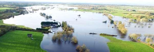
8 There is no doubt that there is a serious increase in how fast and how much water is coming off the mountain during heavy rainfall. There is measureable correlation between heavy rainfall and an immediate increase in river water levels. Within 4 hours, some of the small Slieve Aughty Rivers can rise over 1 metre. The flooding of these communities also has a direct impact on the many SACs, habitats and protected species e.g. In the picture here we see Coole Lake, within an SAC overflowing into a farmyard in Tierneevin and becoming polluted this situation breaks the Coole-Garryland SAC s Conservation Objective and this is just one SAC of 21 in the area. Snapshot of flooding in Tierneevin (Courtesy of Sean Brady Aerial Photography)


9
10 Clarifications/Actions The South Galway Flood Relief Committee, on behalf of the many communities between Slieve Aughty and the Sea, are seeking clarifications and actions from the Windfarms owners/operators and developers Construction/Operations Please provide the following information relating to Derrybrien Windfarm and operations. 1. Windfarm construction 1. How many HA of forestry was felled during construction. Was felling only associated with Windfarm or was felling required outside boundary of windfarm? 2. What was the total length of roads constructed? 3. What was the total area of the concrete bases for each/all turbines? 2. What is the revenue + cost of the windfarm PA? Environment Impact Assessments/Best Practice 1. What is the latest best practice strategy w.r.t windfarms and windfarm drainage management? Have you examples of this? 2. Have any assessments been carried out regarding the impact of hydromorphological changes of the Slieve Aughty mountains due to Windfarm construction and operation (deforestation, draining, turbine construction, road building) and their effect on the lower catchment area. (not just local to Lough Cutra), but through Gort, Castletown, Kiltaran, Coole Lake, Tierneevin, Caherglassaun., Cahermore, Kinvara and Galway bay. 3. Has the windfarm drainage ever been assessed recently? 4. Has the windfarm drainage ever been maintained? EU Case In 2010, The European Commission issued a final warning over breaches of environmental law... the case refers to a Court ruling in July 2008 concerning Ireland's failure to ensure that work on projects that might require an environmental impact assessment (EIA) does not start before the necessary checks or studies are carried out. The Court found that Ireland's use of a system of retention permission to retrospectively approve such work was contrary to the EIA Directive. The Court also found that there had been a failure to undertake a proper prior impact assessment of a wind farm at Derrybrien, County Galway, which caused a major peat slide. No legislation has been adopted to address the issue of retrospective permission identified in the judgment. In the Derrybrien case, the Irish authorities agreed to undertake an EIA to look in detail at further potential issues, however, to date none has been made due to delays in proposed new legislation. 1. What is the current plan w.r.t. the judgement from the European Court of Justice?
11 Water Framework Directive The European Commission s Water Framework Directive (WFD) directs responsible authorities, to implement via the River basin Management Planning process, measures which both prevent deterioration and promote improvements in the quality of the water environment. This includes influencing the location and design of new development, for example minimising diffuse pollutants in water runoff during the construction phase. Engineering works associated with construction of turbines, site access roads, ancillary buildings and transmission infrastructure will impact on the quality of the water environment. Developers should demonstrate these have been properly assessed and put forward suitable mitigation measures to minimise adverse effects. 1. How does current Windfarm development implement the Water Framework directive? a. Does ESB windfarm development have a set of best-practice development methods ensure cross referencing, reflection of developments in legislation, policy, environmental objectives and environmental findings as appropriate? b. In relation to Derrybrien Windfarm, have ESB audited existing drainage network c. In relation to Derrybrien Windfarm, have ESB redesigned the drainage network to minimise contribution to peak flow and increase time period to peak flow? d. In relation to Derrybrien Windfarm, have ESB researched control of flow regime changes from windfarm for sensitive receptors to limit impact on water balance which could affect habitats, species or uses associated with protected areas? Going Forward 1. What are the current/future plans (ESB or related) for windfarms on the Slieve Aughty? 2. What is the expected life of the current Windfarm? What happens to the land then? 3. How are ESB intending to meet Water Framework Objectives and develop a Program of Measures and Standards to deal with pressure from windfarms? 4. What is the timeframe for developing a Program of Measures and Standards to deal with pressure from windfarms? The SGFRC supports windfarm operations in Ireland. However, if windfarm development and operations create hydromorphological changes that could result in the rapid run-off or diminish the natural storage of water on the Slieve Aughty Mountains then windfarm owners should either invest in solutions that will transport this water safely to the sea or incorporate mitigation measure to attenuate and restore water on the mountain. It is our understanding that mandatory guidelines on both EIAs and WFD will need to be fully implemented by ESB or subsidiaries. However, if any aspect of relevant EIAs, or the WFD have not been dealt with sufficiently by the ESB or subsidiaries, then we demand that windfarm operations and developments that have a hydromorphological impact cease until proper hydrological studies, informed Environmental Impact Assessments and WFD measures can be completed and fully implemented. The SGFRC would like to meet up with the ESB as soon as possible to discuss these topics. Yours Sincerely, -David Murray, Chair, South Galway Flood Relief Committee (SGFRC) : Murrcoole@gmail.com
Annex F Scoping Checklist
 Scoping Checklist Table F1: Scoping Checklist Table. Questions to be considered in Scoping /? Which Characteristics of the Project 1. Will construction, operation or decommissioning of the Project involve
These potential changes and their implications are outlined in Annex 1.
 Guidance Note Hydropower Guidance Note: This Guidance Note has been prepared by Natural Resources Wales (NRW) to provide applicants for abstraction and impoundment licences for hydropower schemes with
Adaptation Strategy of the Slovak Republic on Adverse Impacts of Climate Change Overview: Executive Summary
 Adaptation Strategy of the Slovak Republic on Adverse Impacts of Climate Change Overview: Executive Summary Ministry of Environment of the Slovak Republic December 2016 Climate change has caused a wide
Water management in Sweden an introduction
 Water management in Sweden an introduction Andreas Aronsson Inland Water Management Coordinator Five Water Scientifically based borders Five Marine Basins Main Drainage Areas Five out of 21 County Administrations
Oweninny Wind Farm. Oweninny Power Ltd. Environmental Impact Statement. Chapter 20. Indirect and Interaction of Impacts
 Oweninny Wind Farm Oweninny Power Ltd. Chapter 20 Indirect and Interaction of Impacts Copyright ESB International Limited, all rights reserved. TABLE OF CONTENTS 20. INDIRECT AND INTERACTION OF IMPACTS
30 Years of River Quality
 30 Years of River Quality A Retrospective and Prospective View EPA National Water Event Galway Bay Hotel 12-13 June 2013 John Lucey Presentation Outline Overview of past 30 years river quality Problems
Flood risk management and land use planning in changing climate conditions Mikko Huokuna Finnish Environment Institute, SYKE
 10th International Drainage Workshop of ICID 06.-11. July 2008 Flood risk management and land use planning in changing climate conditions Mikko Huokuna Finnish Environment Institute, SYKE Background hydrological
1. Introduction. Keywords Groundwater, Vulbnerability, Aquifer, Aquitard, Vadose zone. Alsharifa Hind Mohammad
 World Environment 2014, 4(1): 22-32 DOI: 10.5923/j.env.20140401.03 New Groundwater Vulnerability Index for the Main Aquifers in Central Catchment Area in Jordan and Validation of the Results Using NO 3
Clifton Marsh Landfill Variation of planning permission 05/09/0376 & 06/09/0395 for the continuation of landfilling until Non Technical Summary
 Clifton Marsh Landfill Variation of planning permission 05/09/0376 & 06/09/0395 for the continuation of landfilling until 2035 Non Technical Summary SLR Consulting Limited Project Ref: 403.00079.00474
Pennsylvania Stormwater Best Management Practices Manual. Chapter 3. Stormwater Management Principles and Recommended Control Guidelines
 Pennsylvania Stormwater Best Management Practices Manual Chapter 3 Stormwater Management Principles and Recommended Control Guidelines 363-0300-002 / December 30, 2006 Chapter 3 Stormwater Management Principles
FACTSHEET INTRODUCTION. help rebalance the water cycle, mitigate the effects of climate change and improve human health and livelihoods.
 1 FACTSHEET INTRODUCTION World Water Day, on 22 March every year, is about focusing attention on the importance of water. This year s theme, Nature for Water, explores nature-based solutions (NBS) to the
Attachment 12 Stage 1 Flood Risk Assessment (IE RP-0001)
") IE0311133-22-RP-0001, Issue A 17/10/2013 Attachment 12 Stage 1 Flood Risk Assessment (IE0311133-30-RP-0001) IE0311133-22-RP-0001_A_02.DOC Flood Risk Assessment Celebrating 40 Years in Business Jazz Pharmaceuticals
IE0311133-22-RP-0001, Issue A 17/10/2013 Attachment 12 Stage 1 Flood Risk Assessment (IE0311133-30-RP-0001) IE0311133-22-RP-0001_A_02.DOC Flood Risk Assessment Celebrating 40 Years in Business Jazz Pharmaceuticals
CHAPTER 3 Environmental Guidelines for WATERCOURSE CROSSINGS GOVERNMENT OF NEWFOUNDLAND AND LABRADOR DEPARTMENT OF ENVIRONMENT AND LABOUR
 GOVERNMENT OF NEWFOUNDLAND AND LABRADOR DEPARTMENT OF ENVIRONMENT AND LABOUR CHAPTER 3 Environmental Guidelines for WATERCOURSE CROSSINGS WATER RESOURCES MANAGEMENT DIVISION Water Investigations Section
(1) Bridge, Road and Railway (Adaptation Project) (2) Bridge, Road and Railway (BAU Development with Adaptation Options)
 Bridge, Road and Railway (Adaptation Project) (2) Bridge, Road and Railway (BAU Development with Adaptation Options)") Sub-sector Guideline: (1) Bridge, Road and Railway (Adaptation Project) (2) Bridge, Road and Railway (BAU Development with Adaptation Options) Basic Concept A. General Concept Climate change will increase
Sub-sector Guideline: (1) Bridge, Road and Railway (Adaptation Project) (2) Bridge, Road and Railway (BAU Development with Adaptation Options) Basic Concept A. General Concept Climate change will increase
Chapter 10 Natural Environment
 Chapter 10 Natural Environment Existing Conditions The Natural Environment Element addresses the protection, conservation, preservation, and restoration of the natural resources the Bayview Ridge Subarea,
Land Management and Flooding. Where are we now?
 Land Management and Flooding Where are we now? Tarland farmer s workshop Andrea Johnstonova, SEPA The talk will cover Some background information: NFM under the FRM Act Implementation so far and examples
Transition Year Geography Lesson
 Transition Year Geography Lesson Biodiversity and Wetlands Wetlands are a vital component of the water cycle. The complex interaction of their elements - water, soil, plants and animals fulfil many important
E. STORMWATER MANAGEMENT
 E. STORMWATER MANAGEMENT 1. Existing Conditions The Project Site is located within the Lower Hudson Watershed. According to the New York State Department of Environmental Conservation (NYSDEC), Lower Hudson
Water Framework Directive. Draft River Basin Management Plans. National Summary Programme of Measures
 Water Framework Directive Draft River Basin Management Plans National Summary Programme of Measures December 2008 Draft River Basin Management Plans National Summary of Programme of Measures Contents 1
Chapter 13 of Agenda 21
 Chapter 13 of Agenda 21 What is Agenda 21? Agenda 21 is the global plan of action that was adopted at the United Nations Conference on Environment and Development (UNCED) held in Rio de Janeiro, Brazil,
20 INDIRECT AND INTERACTION OF IMPACTS
 20 INDIRECT AND INTERACTION OF IMPACTS 20.1 INTRODUCTION The EU Guidelines for the Assessment of Indirect and Cumulative Impacts as well as Impact Interactions states that Including an assessment of the
County of Calaveras Department of Planning
 Date: July 18, 2013 To: From: Project: Advisory Agencies Amy Augustine, AICP - Planner County of Calaveras Department of Planning Rebecca L. Willis, AICP ~ Planning Director Phone (209) 754-6394 Fax (209)
Annesley Andalusite Mine: Section 24G Rectification Process. Consultation with community members 15 June 2017
 Annesley Andalusite Mine: Section 24G Rectification Process Consultation with community members 15 June 2017 AGENDA Welcome and introduction Meeting protocol Purpose of the meeting Project background Project
Application for resource consent Form B Damming and diversion of water
 Application for resource consent Form B Damming and diversion of water Notes Resource use activities must meet all the conditions of any relevant Permitted Activity Rules in the Waikato Regional Plan or
Yes: Y No: N (a) (b) (c) (d) (a) (a) (b) (c) (d) (e)
 (b) (c) (d) (a) (a) (b) (c) (d) (e)") Checklist: 3. Hydropower Stations, Dams and Reservoirs (1) 1 Permits and Explanation 2 Pollution Control (1) EIA and Permits (2) Explanation to the Local Stakeholders Main Check s Have EIA reports been
Checklist: 3. Hydropower Stations, Dams and Reservoirs (1) 1 Permits and Explanation 2 Pollution Control (1) EIA and Permits (2) Explanation to the Local Stakeholders Main Check s Have EIA reports been
Dang Thi Tuoi Biodiversity Conservation Agency (BCA) Ministry of Natural Resources and Environment of Vietnam (MONRE)
 Ministry of Natural Resources and Environment of Vietnam (MONRE)") Dang Thi Tuoi Biodiversity Conservation Agency (BCA) Ministry of Natural Resources and Environment of Vietnam (MONRE) Main Contents: 1. Roles of biodiversity in Vietnam 2. Threats to biodiversity in Vietnam
Dang Thi Tuoi Biodiversity Conservation Agency (BCA) Ministry of Natural Resources and Environment of Vietnam (MONRE) Main Contents: 1. Roles of biodiversity in Vietnam 2. Threats to biodiversity in Vietnam
Module 2: Basic Stormwater Principles
 Module 2: Basic Stormwater Principles 2a. Overview... 2 Inspectors and stormwater management...2 Definition of stormwater runoff...3 VSMP technical criteria...3 Environmental Site Design...4 Best management
Ponds. Pond A water impoundment made by excavating a pit, or constructing a dam or an embankment.
 POND SITE SELECTION AND CONSTRUCTION Uses, Planning, & Design David Krietemeyer Area Engineer USDA-NRCS June 20, 2008 Uses Considerations for Location of Commonly Used Terms Pond A water impoundment made
Water framework directive Implementation in Schleswig-Holstein. Michael Trepel
 Water framework directive Implementation in Schleswig-Holstein Michael Trepel Vision of Water Framework Directive General principal is a natural water status - Common legal frame - European wide comparable
SuDS design criteria for catchment flood protection Are current criteria appropriate?
 SuDS design criteria for catchment flood protection Are current criteria appropriate? Richard Kellagher SuDS Drainage design for catchment flood protection All countries of UK (roughly) in alignment, BUT
The Elbe River Basin: Preliminary evaluation of the answers. Janos J. Bogardi Executive Officer of GWSP
 GWSP-GCI II Workshop on the Water-Energy-Food Security Nexus The Elbe River Basin: Preliminary evaluation of the answers Janos J. Bogardi Executive Officer of GWSP Winnipeg, Canada, 3-4 May 2012 The Elbe
Office of Public Works
 Office of Public Works Arterial Drainage Maintenance An Environmental Approach Richard Dooley, Engineer Gr. 1, Galway, Ireland. Acknowledgements Thanks to Nathy Gilligan, Environment Section OPW, John
Guiding Principles on Sustainable Hydropower Development in the Danube River Basin
 Guiding Principles on Sustainable Hydropower Development in the Danube River Basin Lead Countries : Austria, Romania, Slovenia in the frame of the International Commission for the Danube River Protection
A Freshwater Blueprint for Maritime Canada
 A Freshwater Blueprint for Maritime Canada Union of Nova Scotia Municipalities (UNSM) November 8 th, 2017 William Millar Aquatic Conservation Biologist william.millar@natureconservancy.ca Craig Smith Conservation
Re-plumbing Roadside Ditch Networks
 Re-plumbing Roadside Ditch Networks Ditches Improving management to reduce flooding, water pollution, and in-stream erosion and habitat degradation Rebecca Schneider Dept. Natural Resources Cornell University,
Environmental Impact Assessment and Climate Change Australia
 Environmental Impact Assessment and Climate Change Australia What we are hoping to get through today Overview of EIA in Australia Key climate change issues Projects with climate change adaptation issues
Cork County Development Plan Volume Three: SEA Statement and Natura Impact Report
 Cork County Development Plan 2014 Volume Three: SEA Statement and Natura Impact Report 3 Volume 3: SEA Statement and Natura Impact Report Cork County Development Plan 2014 Contents Section 1 Strategic
EU Water Framework Directive
 EU Water Framework Directive Overview and state of implementation TAIEX Seminar on the Water Framework and Urban Waste Water Directive Zagreb, 25-26 September 2008 Jorge Rodríguez Romero European Commission,
Wetlands in Alberta: Challenges and Opportunities. David Locky, PhD, PWS, PBiol Grant MacEwan University
 Wetlands in Alberta: Challenges and Opportunities David Locky, PhD, PWS, PBiol Grant MacEwan University Overview What & Where Function & Value Alberta s Keystone Ecosystem Losses & Impacts Restoration
A Risky Climate for Southern African Hydro: Assessing hydrological risks and consequences for Zambezi River Basin dams
 A Risky Climate for Southern African Hydro: Assessing hydrological risks and consequences for Zambezi River Basin dams Executive summary Africa is highly vulnerable to the impacts of climate change. Numerous
Dunkellin River and Aggard Stream Flood Relief Scheme
 Dunkellin River and Aggard Stream Flood Relief Scheme Environmental Impact Statement (EIS) Volume I October 2014 MGE0260 rpsgroup.com Dunkellin River and Aggard Stream Flood Relief Scheme Environmental
GUIDE TO THE DEVELOPMENT OF A MINING AND RECLAMATION PLAN IN NEW BRUNSWICK
 PROVINCE OF NEW BRUNSWICK DEPARTMENT OF ENERGY AND RESOURCE DEVELOPMENT Minerals and Petroleum Development Branch GUIDE TO THE DEVELOPMENT OF A MINING AND RECLAMATION PLAN IN NEW BRUNSWICK Guide to the
Ukraine Sustainable Energy Lending Facility (USELF) Strategic Environmental Review (SER) Ecoline EA Centre
 Strategic Environmental Review (SER) Ecoline EA Centre") Ukraine Sustainable Energy Lending Facility (USELF) Strategic Environmental Review (SER) Ecoline EA Centre Objectives of Strategic Environmental Review (SER) The European Bank for Reconstruction and Development
Ukraine Sustainable Energy Lending Facility (USELF) Strategic Environmental Review (SER) Ecoline EA Centre Objectives of Strategic Environmental Review (SER) The European Bank for Reconstruction and Development
PROPOSAL FOR VARIATION ON THE DONEGAL COUNTY DEVELOPMENT PLAN
 PROPOSAL FOR VARIATION ON THE DONEGAL COUNTY DEVELOPMENT PLAN Presentation to Councillors of Donegal County House Lifford Monday 21 October 2013 Presentation given by Peter Crossan, Planning and Research
Recommended Resources: The following resources may be useful in teaching this lesson:
 Unit E: Basic Principles of Soil Science Lesson 7: Understanding Soil Erosion and Management Practices Student Learning Objectives: Instruction in this lesson should result in students achieving the following
Application of SWAT Model in land-use. change in the Nile River Basin: A Review
 Application of SWAT Model in land-use change in the Nile River Basin: A Review By: Marwa Ali, Okke Batelaan and Willy Bauwens 15-6-2011 Application of SWAT Model in land-use 1 change in the Nile River
RIPARIAN PROTECTION Questions & Answers
 RIPARIAN PROTECTION Questions & Answers 1. What is a riparian corridor and why is it important? Answer: A riparian corridor is a space on both sides of a stream or around a lake or wetland. The corridor
What is a stormwater utility fee?
 What is a stormwater utility fee? A stormwater utility fee is similar to a water or sewer utility fee. In essence, customers pay a fee to convey stormwater from their properties. The City of Goodlettsville
The Islamic University of Gaza- Civil Engineering Department Sanitary Engineering- ECIV 4325 L5. Storm water Management
 The Islamic University of Gaza- Civil Engineering Department Sanitary Engineering- ECIV 4325 L5. Storm water Management Husam Al-Najar Storm water management : Collection System Design principles The Objectives
Temporary Watercourse Crossing: Culverts
 Temporary Watercourse Crossing: Culverts DRAINAGE CONTROL TECHNIQUE Low Gradient Velocity Control Short Term Steep Gradient Channel Lining Medium-Long Term Outlet Control Soil Treatment Permanent Symbol
Tropical Cyclone Case Study Hurricane Katrina (2005)
") Tropical Cyclone Case Study Hurricane Katrina (2005) Hurricane Katrina formed over the Bahamas in the Western area of the Atlantic Ocean. The Hurricane hit the city of New Orleans, the most populated city
Tropical Cyclone Case Study Hurricane Katrina (2005) Hurricane Katrina formed over the Bahamas in the Western area of the Atlantic Ocean. The Hurricane hit the city of New Orleans, the most populated city
Created by Simpo PDF Creator Pro (unregistered version) Asst.Prof.Dr. Jaafar S. Maatooq
 Asst.Prof.Dr. Jaafar S. Maatooq") Lect.No.9 2 nd Semester Barrages, Regulators, Dams 1 of 15 In order to harness the water potential of a river optimally, it is necessary to construct two types of hydraulic structures, as shown in Figure
Lect.No.9 2 nd Semester Barrages, Regulators, Dams 1 of 15 In order to harness the water potential of a river optimally, it is necessary to construct two types of hydraulic structures, as shown in Figure
Sustainable Catchment Area Management Planning (SCAMP NI)
") CIEEM Conference 24 th November 2014 Sustainable Catchment Area Management Planning (SCAMP NI) a more environmentally sustainable approach to improving water quality Roy Taylor Catchment Manager Presentation
CIEEM Conference 24 th November 2014 Sustainable Catchment Area Management Planning (SCAMP NI) a more environmentally sustainable approach to improving water quality Roy Taylor Catchment Manager Presentation
1. Purpose and scope. 2. When to consult SEPA
 Page no: 1 of 5 1. Purpose and scope 1.1 This guidance note provides advice to the Forestry Commission Scotland (FCS) and forest managers (including Forest Enterprise Scotland) on how and when to consult
Adaptation planning at different spatial scales
 Adaptation planning at different spatial scales Using TCPA Publication Adaptation by Design as the main source GerGerry Metcalf UKCIP UKCIP Key adaptation principles for planning UKCIP Seek opportunities
Advice to decision maker on coal mining project
 . Advice to decision maker on coal mining project IESC 2015-063: West Muswellbrook Project New Development Requesting agency The New South Wales Mining and Petroleum Gateway Panel Date of request 27 January
WATERSHED. Maitland Valley. Report Card 201
 Maitland Valley WATERSHED Report Card 201 The Maitland Valley Conservation Authority has prepared this report card as a summary on the state of our forests, wetlands, surface water, and ground water resources.
Environmental Impact Assessment (EIA) Owen Struthers Development Management Branch Welsh Government
 Owen Struthers Development Management Branch Welsh Government") Environmental Impact Assessment (EIA) Owen Struthers Development Management Branch Welsh Government Environmental Impact Assessment Introduction New Directive: Directive 2014/52/EU of the European Parliament
Environmental Impact Assessment (EIA) Owen Struthers Development Management Branch Welsh Government Environmental Impact Assessment Introduction New Directive: Directive 2014/52/EU of the European Parliament
Port of Manzanillo. Port of Manzanillo: Climate Risks and Opportunities. IAIA Symposium: Sustainable Mega- Infrastructure and Impact Assessment
 Port of Manzanillo Port of Manzanillo: Climate Risks and Opportunities IAIA Symposium: Sustainable Mega- Infrastructure and Impact Assessment Panama City, December 3, 2015 Vladimir Stenek, IFC, World Bank
APPENDIX H Guidance for Preparing/Reviewing CEQA Initial Studies and Environmental Impact Reports
 APPENDIX H H.1 Guidance for Preparing and Reviewing CEQA Initial Studies Step 1: Consider the Project Characteristics as Provided by the Project Applicant Review the project application and draft plan
Evolution of the Environmental Acquis
 Evolution of the Environmental Acquis Hugo DE GROOF Directorate-General Environment Chief Scientist, Research and Innovation Unit European Commission INSPIRE TEAM Eurostat DG Environment Joint Research
INTRODUCTION cont. INTRODUCTION. What is Impervious Surface? Implication of Impervious Surface
 Mapping Impervious Surface Changes In Watersheds In Part Of South Eastern Region Of Nigeria Using Landsat Data By F. I. Okeke Department of Geoinformatics and Surveying, University of Nigeria, Enugu Campus
Chapter 2: Aquifers and groundwater
 Chapter 2: Aquifers and groundwater Groundwater movement through aquifers is driven by differences in groundwater levels or pressure and is controlled by how porous the material is that it passes through.
Title Action Plan toward Effective Flood Hazard Mapping in My Country
 Title Action Plan toward Effective Flood Hazard Mapping in My Country JICA region focused training course on flood hazard mapping Sep 2006 LAI TUAN ANH Division of Geodesy Department of Planning and Management
Preface. MNR # Queen s Printer for Ontario, 2012 ISBN (PRINT) ISBN (PDF)
 ISBN (PDF)") Preface In 2008, the inter-agency Drainage Act & Section 28 Regulations Team (DART) was established by the Ministry of Natural Resources (MNR) and the Ministry of Agriculture, Food and Rural Affairs (OMAFRA)
Preface In 2008, the inter-agency Drainage Act & Section 28 Regulations Team (DART) was established by the Ministry of Natural Resources (MNR) and the Ministry of Agriculture, Food and Rural Affairs (OMAFRA)
Characteristics of Land Resources
 Chapter Chapter 1 Characteristics of Land Resources The geology, soils and topography of Woodford County T he geology, soils and topography of an area are important to the community planning process for
Watershed: an area or ridge of land that separates waters flowing to different rivers, basins, or seas. It is the interdependent web of living
 Watershed: an area or ridge of land that separates waters flowing to different rivers, basins, or seas. It is the interdependent web of living organisms that inhabit a geographic area and depend on it
Chapter 6. Hydrology. 6.0 Introduction. 6.1 Design Rainfall
 6.0 Introduction This chapter summarizes methodology for determining rainfall and runoff information for the design of stormwater management facilities in the City. The methodology is based on the procedures
WATER RESOURCES MANAGEMENT IN THE DANUBE RIVER BASIN. Prof. Dr. Laszlo Vermes
 WATER RESOURCES MANAGEMENT IN THE DANUBE RIVER BASIN Prof. Dr. Laszlo Vermes The Danube is one of the greatest rivers in the World second biggest in Europe (after the Volga) Total length: 2842 km watershed
Water Resources on PEI: an overview and brief discussion of challenges
 Water Resources on PEI: an overview and brief discussion of challenges Components: Components and links Atmospheric water Surface water (including glacial water) Groundwater Links: Precipitation (atm(
STANDARD. Document information. Version: v4.8 Dec Date: Dec (c) 2012 European Water Partnership. All rights reserved.
 2012 European Water Partnership. All rights reserved.") STANDARD Document information Version: v4.8 Dec 2012 Language: English Date: Dec 2012 (c) 2012 European Water Partnership. All rights reserved. PAGE LEFT BLANK ON PURPOSE European Water Stewardship (EWS)
STANDARD Document information Version: v4.8 Dec 2012 Language: English Date: Dec 2012 (c) 2012 European Water Partnership. All rights reserved. PAGE LEFT BLANK ON PURPOSE European Water Stewardship (EWS)
Reading the River, Summer Watersheds and Streams A unit for 8 th Grade Science. Arthur H. Shutt III. Bullitt Lick Middle School
 Reading the River, Summer 2001 Watersheds and Streams A unit for 8 th Grade Science Arthur H. Shutt III Bullitt Lick Middle School Bullitt County, Kentucky 1 Watersheds and Streams Grade Level: 8 Objectives
The EU Water Framework Directive
 The EU Water Framework Directive Why is it important to the recreational boating industry? SEPTEMBER 2004 The EU Water Framework Directive: why is it important to the recreational boating industry? The
Understanding Soil Erosion and Management Practices
 Lesson C6 8 Understanding Soil Erosion and Management Practices Unit C. Plant and Soil Science Problem Area 6. Basic Principles of Soil Science Lesson 8. Understanding Soil Erosion and Management Practices
Implementing Stormwater Management through Split-Flow Drainage Design
 Implementing Stormwater Management through Split-Flow Drainage Design Stuart Patton Echols PhD, ASLA, RLA Assistant Professor - Department of Landscape Architecture 210 Engineering Unit D Center for Watershed
Unit E: Basic Principles of Soil Science. Lesson 7: Understanding Soil Erosion and Management Practices
 Unit E: Basic Principles of Soil Science Lesson 7: Understanding Soil Erosion and Management Practices 1 Important Terms Accelerated erosion Conservation tillage Cover crops Diversion ditches Geologic
Hydropower Guidance Note: HGN 7 Competing Schemes
 Guidance Note Hydropower Guidance Note: HGN 7 Competing Schemes This guidance is not intended as a statement of law and should be read in combination with and in the context of the relevant enactments
In Your House and in Your Yard, Watch for Water, Be on Guard
 In Your House and in Your Yard, Watch for Water, Be on Guard KEY TERMS Arroyo: A water-carved gully or a normally dry creek found in arid or desert regions. Dam: A barrier built across a river, stream
King County Flood Control District approves grants for flood prevention projects Regional projects to benefit from district funds
 News Release Contact: Al Sanders 206-477-1016 August 31, 2015 Flood Control District approves grants for flood prevention projects Regional projects to benefit from district funds The Flood Control District
When it Rains it Pours
 Lesson Summary: Students will understand how water is absorbed into the ground. They will also be able to explain the difference between pervious and impervious surfaces. Students will also learn about
Climate change and lakes: effects on ecological status and status assessment. Peeter Nõges Estonian University of Life Sciences
 Climate change and lakes: effects on ecological status and status assessment Peeter Nõges Estonian University of Life Sciences 600 500 400 300 200 100 0 NAO and water level NAO and water level 1999 1859
Spoil and Water. Irish Ports Association Conference Ciaran Callan Dublin Port Company. 26 th September 2008
 Spoil and Water Ciaran Callan Dublin Port Company Irish Ports Association Conference 2008 26 th September 2008 Disposal of Dredge Material: Regulation and Process of Application Requirement for disposal
BULGARIA - WIND FARMS IN BALCHIK AND KALIAKRA (VIA PONTICA)
") SUMMARY OF GOVERNMENT REPORT File open: BULGARIA - WIND FARMS IN BALCHIK AND KALIAKRA (VIA PONTICA) Strasbourg, 2 December 2015 Following the Standing Committee Recommendation the Environmental Impact
SUMMARY OF GOVERNMENT REPORT File open: BULGARIA - WIND FARMS IN BALCHIK AND KALIAKRA (VIA PONTICA) Strasbourg, 2 December 2015 Following the Standing Committee Recommendation the Environmental Impact
Tropical Agro-Ecosystem Function
 Tropical Agro-Ecosystem Function Soil factors affecting agriculture in the tropics Soil quality indicators Dr. Ronald F. Kühne; rkuehne@gwdg.de Georg-August-University Göttingen Department for Crop Sciences
Water Framework Directive Water for Life and Livelihoods
 England and Wales Approach to Implementation UKELA Conference 17th June 2005 Dr Martin Griffiths Environment Agency England and Wales Purpose Prevent deterioration, enhance status of aquatic ecosystems
Environmental Information Worksheet
 Environmental Information Worksheet Water System Owner (Attach additional sheets if necessary) Needs and Alternatives Provide a brief narrative that describes: Current drinking water system needs. Project
Pasquia Area Drainage and Pumping System
 Pasquia Area Drainage and Pumping System Review of Operating Guidelines Public Open House August 22, 2017 Welcome! Manitoba Infrastructure, the Rural Municipality (RM) and The Pas and District Farmer s
Water Balance Methodology
 Water Balance Methodology Integrating the Site with the Watershed and the Stream March 2012 An initiative under the umbrella of the Water Sustainability Action Plan for British Columbia Water Balance Methodology
The Dublin Statement on Water and Sustainable Development
 The Dublin Statement on Water and Sustainable Development Dublín, Ireland, January 31, 1992 Contents Introduction Guiding Principles Principle 1 Principle 2 Principle 3 Principle 4 The Action Agenda Alleviation
Susan P. Abano Engineer IV Policy and Program Division
 National Water Resources Board Integrated Water Resources Management Susan P. Abano Engineer IV Policy and Program Division National Water Resources Board Outline Philippines Water Resources Situationer
Hydrology and Water Management. Dr. Mujahid Khan, UET Peshawar
 Hydrology and Water Management Dr. Mujahid Khan, UET Peshawar Course Outline Hydrologic Cycle and its Processes Water Balance Approach Estimation and Analysis of Precipitation Data Infiltration and Runoff
Adaptation planning at different spatial scales
 Adaptation planning at different spatial scales Using TCPA Publication Adaptation by Design as the main source GerGerry Metcalf UKCIP UKCIP Key adaptation principles for planning UKCIP Seek opportunities
Section XXV Preconstruction Assessments and Damage Mitigation Procedures
 Section XXV Preconstruction Assessments and Damage Mitigation Procedures A. Introduction - In recent years, HRSD has received an increasing number of complaints from residents and locality staff regarding
Will be modified map from GIS 6/16 EOD
 Middle-Snake-Tamarac Rivers Watershed District Judicial Ditch #19 Watershed Regional Conservation Partnership Program (RCPP) Public Scoping Meeting September 26, 2016 Will be modified map from GIS 6/16
TOPIC 1: WHY DO WE STUDY HYDROLOGY AND OPEN CHANNEL HYDRAULICS TABLE OF CONTENTS
 Unit CIV2262: Waterway Engineering 1.1 TOPIC 1: WHY DO WE STUDY HYDROLOGY AND OPEN CHANNEL HYDRAULICS TABLE OF CONTENTS 1. PREVIEW...2 1.1. Introduction... 2 1.2. Objectives... 2 1.3. Readings... 3 2.
This is a working draft report provided for information purposes only, and may be modified prior to finalisation. It has been prepared on the basis
 This is a working draft report provided for information purposes only, and may be modified prior to finalisation. It has been prepared on the basis of the design and engineering work as part of the feasibility
ENVS 435: Watershed Management. 3 Credits INSTR.: Dr. R.M. Bajracharya
 ENVS 435: Watershed Management 3 Credits INSTR.: Dr. R.M. Bajracharya Unit 1: Introduction - Watershed Concepts Definitions of watershed The elevated line separating the head streams which are tributaries
Community-Based Watershed Management
 Page 1 of 6 Ohio State University Fact Sheet School of Natural Resources 2021 Coffey Road, Columbus, Ohio 43210 Community-Based Watershed Management WS-0001-00 Joe Bonnell Project Coordinator, Ohio Watershed
A. EXECUTIVE SUMMARY. 1. Water status management. 1.1 Water status
 A. EXECUTIVE SUMMARY 1. Water status management 1.1 Water status Data and analyses of water status indicators suggest that the water resources in Croatia are subject to the impact of human activities.