Today s Webinar: Types of Monitoring and Assessment Data and What They Mean
|
|
|
- Arline Bishop
- 5 years ago
- Views:
Transcription

1 Welcome to the 1 st Webinar in the Series Monitoring & Assessment for Watershed Plans: Identifying, Accessing, and Using Data to Protect and Restore Indiana s Waters Each Monday in May at noon Today s Webinar: Types of Monitoring and Assessment Data and What They Mean Presented by Barry Tonning, Tetra Tech

2 Types of Monitoring and Assessment Data and What They Mean

3 Top Two Questions for State Water Resource Agency Personnel: Where are the best places to fish? Aquatic life support Is my water safe to drink? Human health considerations

4 Watershed planning & management Watershed planning is a weight-of-evidence based cycle of assessments and actions to improve water quality What measures can we use for assessments?
, such as water")
5 What should we monitor? Indicators that: Characterize the watershed Define and/or refine your understanding of the problem(s), such as water quality criteria violations, etc. Show changes in targeted water quality or habitat conditions

6 Measuring watershed health Measurements can be taken: In the stream, river, lake, or wetland Along the bank area Within the uplands regions Land uses/cover/mgmt practices Agricultural crops & livestock Logging and mining sites Towns and cities
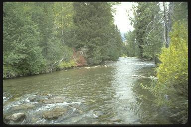
7 Measurements in the stream or river
8 How scientists conceptualize the variables affecting water quality: Chemical Variables Flow Regime Water Resource Integrity Biotic Factors Habitat Structure Energy Source
9 Structural, functional, & other elements impacting water quality
 in-stream water quality")
10 Quick review of the most common (and useful) in-stream water quality indicators

11
 and larger weighed (mg/l) Suspended sediment concentration: same,")

12 How sediment is measured Total suspended solids: part of sample filtered; ~ 0.45 microns (µm) and larger weighed (mg/l) Suspended sediment concentration: same, but all of sample filtered Settleable solids: Imhoff cone, 1 hr Bedload sediment: Scour chains, volumetric estimates Suspended and bedload sediment: both are added together


13 We can also measure water cloudiness, or turbidity
14 We can also measure water cloudiness, or turbidity
15 Target values for solids & turbidity Parameter Target Reference/Other Information Suspended U.S. EPA recommendation for Max: 25.0 mg/l Sediment excellent fisheries Concentration U.S. EPA recommendation for good Range: mg/l (SSC) to moderate fisheries Wawasee Area Conservancy Max: 80.0 mg/l Foundation recommendation to protect aquatic life in lake systems Max: 30.0 mg/l IDEM draft TMDL target Total Suspended Solids (TSS) Range: mg/l Concentrations within this range reduce fish concentrations (Waters, 1995) Max: 40.0 mg/l New Jersey criteria for warm water streams Max: 46.0 mg/l Minnesota TMDL criteria for protection of fish/macroinvertebrate health Minnesota TMDL criteria for Turbidity Max: 25.0 NTU protection of fish/macroinvertebrate health Max: 10.4 NTU U.S. EPA recommendation


16 Dissolved oxygen: a key water quality measure
17 Dissolved Oxygen Levels Over 14? Check your test! mg/l excellent 7-10 mg/l good 4-7 mg/l fair 0-4 mg/l - poor
18 D O levels fluctuate during the day 6:00 AM
 Acidic precipitation Disturbances (mine wastes) Polluted runoff Discharges")
19 ph: an important parameter! Measures hydrogen ion strength Indicates acidity or alkalinity ph is affected by: Geology (e.g., limestone) Acidic precipitation Disturbances (mine wastes) Polluted runoff Discharges

20 Indiana WQC

21 The importance of maintaining acceptable ph ranges...


22 Nutrients: phosphorus & nitrogen Lab analysis required
 Runoff sources: dissolved & particulate Major portion from cultivated fields (~ 75-90%) is")
23 Phosphorus Major concern for inland fresh waters Sources include wastewater plants (~ 1 5 mg/l) and polluted runoff (variable) Runoff sources: dissolved & particulate Major portion from cultivated fields (~ 75-90%) is soil-based

24 Phosphorus Dissolved form is usually less, but is IMMEDIATELY bio-available to algae Dissolved phosphorus increases in pastures, reduced tillage fields Concentrations of >0.3 mg/l linked to water quality impairment (.05 mg/l for lakes)
 Ammonia toxic at very low (~.02 -.")
25 Nitrogen Nitrogen is measured as nitrate (NO3) plus nitrite (NO2) Supports algae growth; mostly a concern in coastal waters Drinking water limit is 10 mg/l (nitrate) Ammonia toxic at very low (~ mg/l) concentrations (higher temp & ph = more NH3 ammonia, less NH4 ammonium)
26 Target values for nitrogen & phosphorus Parameter Target Reference/Other Information Max: mg/l U.S. EPA recommendation * Nitrate-nitrogen (NO3) Ortho-Phosphate; a/k/a Soluble reactive phosphorus (SRP) Total Kjeldahl Nitrogen (TKN) Total Phosphorus Max: 1.0 mg/l 1.5 mg/l Ohio EPA recommended criteria for Warm Water Habitat (WWH) headwater streams and Modified Warm Water Habitat (MWH) headwater streams Dividing line between mesotrophic and eutrophic streams (Dodd et al. 1998) 10.0 mg/l IDEM draft TMDL target Max: mg/l Wawasee Area Conservancy Foundation recommendation for lake systems Max: mg/l U.S. EPA recommendation * Max: mg/l 0.07 mg/l Max: 0.08 mg/l Max: 0.3 mg/l U.S. EPA recommendation Dividing line between mesotrophic and eutrophic streams (Dodd et al. 1998) Ohio EPA recommendation to protect aquatic biotic integrity in WWH IDEM draft TMDL target

27
")
28 Conductivity meter (and you get a thermometer!)

29 Temperature: different ranges for different biological functions

30 Metal monitoring info is available at the NEMI web site www. nemi. gov


31 Fish consumption advisories based on fish tissue analysis


32 Bacteria a human health threat. Most programs now measure E. coli bacteria colony-forming units per 100 milliliters of raw water
33 Water quality criteria for Indiana surface waters Parameter Total Ammonia (NH3) Dissolved Oxygen (DO) E. coli Nitrite-N + Nitrate-N Temperature Target Range between 0.0 and 0.21 mg/l depending upon temperature and ph Min: 4.0 mg/l Max: 12.0 mg/l Min: 6.0 mg/l in coldwater fishery streams Min: 7.0 mg/l in spawning areas of coldwater fishery streams Max: 235 CFU/ 100mL in a single sample Max: Geometric Mean of 125 CFU/ 100mL from 5 equally spaced samples over a 30-day period Max: 10 mg/l in waters designated as a drinking water source Dependent on time of year and whether stream is designated as a cold water fisheries

34 Assessing biota and habitat


35 Macroinvertebrate analysis: inexpensive & comprehensive Hellgrammite Larva Dobsonfly Adult Mayfly Adult Mayfly Larva Stonefly Larva Stonefly Adult Dragonfly Larva Dragonfly Adult


36 Organisms can be categorized according to their tolerance for pollution or poor habitat conditions Good Mid Range Poor

37 Hoosier Riverwatch Summary ID Key Method is simple & volunteer-friendly

38 Note: Organisms in the river or stream will vary... small headwaters streams are different from large rivers!
39 Other biological indicators Birds Fish Vascular Plants Amphibians Algae
 More DELTs deformities, eroded fins, lesions,")
40 Symptoms of lower quality Bigger percentage of tolerant species Lower proportion of predators Higher numbers of "generalists Greater proportion of exotics (invasive species) More DELTs deformities, eroded fins, lesions, tumors

41 Why is flow important? Flow data at US Geological Survey web site:
42 Temperature, flow, and some water quality data is available at the USGS web site

43 Optimal Siltation and other structural (physical) aspects of the stream affects habitat Suboptimal Marginal Poor


44 Stream Bottom Structure & Critter Cover Optimal Poor Range


45 Embeddedness Optimal Poor Range


46 Velocity-Depth Combinations Optimal Poor Range


47 Sediment Deposition Optimal Poor Range


48 Channel Flow Status Optimal Poor Range


49 Channel Alteration Optimal Poor Range


50 Optimal Frequency of Riffles Poor Range
51 Indiana s Qualitative Habitat Evaluation Index is based on Ohio s approach protocols.pbwork s.com/f/idem+q HEI+SOP.pdf

52 Qualitative Habitat Evaluation Index Substrate stream bottom & composition Instream cover Channel morphology shape and alterations Bank erosion & riparian zone Pool and glide quality Riffle quality Gradient Human impacts

53 Hoosier Riverwatch QHEI form summarizes the same parameters...
54 Measurements along the bank area

55 Measureable indicators along the bank area: Riparian buffer


56 Bank Stability Poor Range Optimal


57 Bank Vegetative Protection Optimal Poor Range


58 Riparian Vegetative Zone Width Poor Range Optimal

59 Summary: types of data needed for holistic assessments Chemical DO, ph, nutrients, metals, pesticides Physical Flow, temp, turbidity, habitat, pool/riffle Biological Indices of biological integrity, macro invertebrates, bacteria, riparian cover
60 Future Webinars in this Series May 10: Which Data Are Important and Why? May 17: Using Data to Support Watershed Protection and Restoration Decisions May 24: Dealing With Uncertainty in Watershed Assessments Information and Registration at Click on the Webinars tab
Acidity and Alkalinity:
 Evaluation of Pollution Sources to Lake Glenville Quarterly Report December 2018 Kimberlee K Hall, PhD Environmental Health Program, Western Carolina University Summary Chemical and microbial analysis
Monitoring Stormwater Best Management Practices: Why Is It Important and What To Monitor
 Monitoring Stormwater Best Management Practices: Why Is It Important and What To Monitor Scott D. Struck, Ph.D. US EPA, Urban Watershed Management Branch New Jersey Water Monitoring Workshop 4/20/2006
Santa Rosa Creek Water Quality Results 2004
 Santa Rosa Creek Water Quality Results 24 Community Clean Water Institute Site Description: SRC4: Off 3rd Street in downtown Santa Rosa. Behind the Vineyard Hotel just West of Highway 11 along the Prince
Impacts to Aquatic Habitats from Land-Use or Is It Polluted?
 Impacts to Aquatic Habitats from Land-Use or Is It Polluted? Water Pollution is: The addition of excessive carbon to a system The addition of large amounts of materials to water that causes adverse changes
A Claytor Nature Center Stream Monitoring Experience
 A Claytor Nature Center Stream Monitoring Experience Conduct field investigations in which distinctions are made among observations, hypotheses, results and conclusions Perform a visual habitat assessment
Aquatic Science Unit 2. Water Quality and Water Pollution
 Aquatic Science Unit 2 Water Quality and Water Pollution What is a healthy water body? In your own words, take a moment to describe what you believe are some of the characteristics of a healthy stream
Environmental Assessment of the Jeffersonville Watersheds
 Environmental Assessment of the Jeffersonville Watersheds - FINAL REPORT - Prepared by: Melissa A. L. Clark School of Public and Environmental Affairs Indiana University Bloomington, Indiana Prepared for:
Mock Stream Habitat Assessment: Bringing the outside in!
 Mock Stream Habitat Assessment: Bringing the outside in! Objectives: At the end of this activity, youth should be able to: Assess the overall health of a stream habitat Apply the terms abiotic and biotic
Water Chemistry Monitoring
 Chicago River Fieldtrip Activity Summary Students use basic to advanced water quality monitoring kits and probes to assess the water quality of the Chicago River. Water chemistry kits available for loan
2012 Mill Creek Watershed Habitat Assessment Level 3 Project Study Plan Results
 2012 Mill Creek Watershed Habitat Assessment Level 3 Project Study Plan Results Cranberry Run This project study plan was financed through a Sub-grant from the Ohio EPA with funds from the State of Ohio.
Cut lines. Definition: Source Examples: Common examples
 (name with color banner for parameter type Chemical (yellow), Biological (green) or physical (blue) (name with color banner for parameter type Chemical (yellow), Biological (green) or physical (blue) Common
Ellen Bailey. UWW Educator training January 13,
 Ellen Bailey UWW Educator training January 13, 2017 ellen.bailey@usu.edu 801-536-4432 Utah Water Watch Partnership between USU Extension and the DWQ Started in 2012 Trained 750+ volunteers, monitoring
Redwood Shores Lagoon August Monthly Water Quality Monitoring Report
 Redwood Shores Lagoon August Monthly Water Quality Monitoring Report Prepared for Redwood City Public Works Services Department 1400 Broadway Redwood City, CA 94063-2594 Prepared by Clean Lakes, Inc. P.
REPORT. Report No: 2013/0958 Prepared For: Natural Resources Committee Prepared By: Dean Olsen, Environmental Resource Scientist Date: 11 July 2013
 REPORT Document Id: A544088 Report No: 2013/0958 Prepared For: Natural Resources Committee Prepared By: Dean Olsen, Environmental Resource Scientist Date: 11 July 2013 Subject: Waianakarua River Water
Hydrology and Water Quality. Water. Water 9/13/2016. Molecular Water a great solvent. Molecular Water
 Hydrology and Water Quality Water Molecular Water Exists as an equilibrium But equilibrium altered by what is dissolved in it Water Molecular Water a great solvent In reality, water in the environment
Boulder Elkhorn TMDL Project. TMDL Document Public Comment Meeting June 27, 2013
 Boulder Elkhorn TMDL Project TMDL Document Public Comment Meeting June 27, 2013 Presentation Outline: What are TMDLs? Boulder Elkhorn TMDL Project Area What s in a TMDL document? Sediment Overview Temperature
Watershed Investigations: How to Assess the Health of a Stream
 Watershed Investigations: How to Assess the Health of a Stream By Joan Chadde, Western UP Center for Science, Mathematics & Environmental Education. All photos by author, unless otherwise noted. Why Monitor
Regional Watershed Planning. Calumet Summit 2010: A Call to Connect Calumet Conference Center April 27, 2010
 Regional Watershed Planning Calumet Summit 2010: A Call to Connect Calumet Conference Center April 27, 2010 Basins The Calumet Region Watershed Communities Land Cover- 2006 Impervious Cover 303d Listed
Which Data Are Important And Why? Barry Tonning Tetra Tech
 Which Data Are Important And Why? Barry Tonning Tetra Tech Last week... In-stream monitoring parameters Chemical, physical, biological Including in-stream habitat parameters Bank area assessment Vegetation,
Using Data to Support Watershed Protection and Restoration Decisions
 Using Data to Support Watershed Protection and Restoration Decisions CSI Watershed You found the (water) body. There were signs of a struggle. What happened? The evidence will come from lots of places...
Hydrology and Water Quality. Water. Water 9/11/2018. Molecular Water a great solvent. Molecular Water
 Hydrology and Water Quality Water Molecular Water Exists as an equilibrium But equilibrium altered by what is dissolved in it Water Molecular Water a great solvent In reality, water in the environment
Nutrients. Water Quality Planning Branch Water Division Arkansas Department of Environmental Quality
 Nutrients Water Quality Planning Branch Water Division Arkansas Department of Environmental Quality Water Quality & Biological Data Water Quality Standards & Criteria Assessment Permit Limitations Impairment
Summary. River. 5 th 8 th. about the. Chemical. anteceden. Grade Level: 5 th. 12 th. Objectives: instructions to. determine the. Chicago River Field
 Water Chemistry Monitoring Chicago River Field Trip Activity Summary Students use basic to advanced water quality monitoring kits and probes to assess the water quality of the Chicago River. Water chemistry
Factsheet: Town of Deep River Water Quality and Stormwater Summary
 79 Elm Street Hartford, CT 06106-5127 www.ct.gov/deep Affirmative Action/Equal Opportunity Employer Factsheet: Town of Deep River Water Quality and Stormwater Summary This document was created for each
Water Quality Testing
 Field Experience Water Quality Testing How s the Water? Overview Students will use chemical tests to determine the water quality of a local pond. Teacher Background: Water Quality In 1972 the Clean Water
Jackson Lake Analysis
 Jackson Lake Analysis Lake Zones Lake Zones Limnetic Zone- open water far from shore Light penetrates shallow, allowing photosynthesis Supports phytoplankton (algae, protists, cyanobacteria) which then
ARKANSAS NUTRIENT CRITERIA DEVELOPMENT. EPA Region 6 Nutrient RTAG Dallas, Texas April 14, 2015
 ARKANSAS NUTRIENT CRITERIA DEVELOPMENT EPA Region 6 Nutrient RTAG Dallas, Texas April 14, 2015 CRITERIA DEVELOPMENT MILESTONES Assessment Methodology Beaver Lake Wadeable Streams Nutrient Trading-Act 335
Reporting Period: 01/01/2008 to 12/31/2008. Understanding the Level 2 Stream Monitoring Data Report
 St Croix River at Old HWY 53 At Gordon, 163118 Saint Croix River Latitude: 46.252617, Longitude: -91.79963 Susan Peterson, Friends of the Saint Croix Headwaters James Heim, Friends of the Saint Croix Headwaters
Redwood Shores Lagoon November 2016 Monthly Water Quality Monitoring Report
 Redwood Shores Lagoon November 2016 Monthly Water Quality Monitoring Report Prepared for Redwood City Public Works Services Department 1400 Broadway Redwood City, CA 94063-2594 Prepared by Clean Lakes,
Factsheet: City of West Haven Water Quality and Stormwater Summary
 79 Elm Street Hartford, CT 06106-5127 www.ct.gov/deep Affirmative Action/Equal Opportunity Employer Factsheet: City of West Haven Water Quality and Stormwater Summary This document was created for each
Presented by Jack Pflaumer
 Presented by Jack Pflaumer Bureau of Environmental Analysis, Restoration and Standards Division of Water Monitoring and Standards New Jersey Department of Environmental Protection February 23, 2017 Agenda
Redwood Shores Lagoon February 2019 Monthly Water Quality Monitoring Report
 Redwood Shores Lagoon February 2019 Monthly Water Quality Monitoring Report Prepared for Redwood City Public Works Services Department 1400 Broadway Redwood City, CA 94063-2594 Prepared by Clean Lakes,
Flow-Based Surrogate TMDLs, A Case Study in Ohio
 Lower Grand River TMDL January 2012 This fact sheet describes the characteristics of a good surrogate total maximum daily load (TMDL) and the factors that should be considered when selecting a surrogate
Factsheet: Town of East Lyme Water Quality and Stormwater Summary
 79 Elm Street Hartford, CT 06106-5127 www.ct.gov/deep Affirmative Action/Equal Opportunity Employer Factsheet: Town of East Lyme Water Quality and Stormwater Summary This document was created for each
Basics of Water Quality Sheila Murphy
 Basics of Water Quality Sheila Murphy Water quality: The chemical, physical, and biological characteristics of water, usually in respect to its suitability for a particular purpose Water quality can include:
2012 Nutrient Regulations Update
 2012 Nutrient Regulations Update OWEA Government Affairs Workshop March 1, 2012 Guy Jamesson, PE, BCEE Malcolm Pirnie, The Water Division of ARCADIS Imagine the result Agenda Nutrient impacts Nutrient
Reporting Period: 01/01/2010 to 12/31/2010. Understanding the Level 2 Stream Monitoring Data Report
 Eau Claire River at Outlet Bay Rd, 10029003 Upper Eau Claire Lake Latitude: 46.302803, Longitude: -91.50336 Susan Peterson, Friends of the Saint Croix Headwaters John Kudlas, Friends of the St.Croix Headwaters
Redwood Shores Lagoon May 2017 Monthly Water Quality Monitoring Report
 Redwood Shores Lagoon May 2017 Monthly Water Quality Monitoring Report Prepared for Redwood City Public Works Services Department 1400 Broadway Redwood City, CA 94063-2594 Prepared by Clean Lakes, Inc.
Appendix X: Non-Point Source Pollution
 Appendix X: Non-Point Source Pollution Sources Nonpoint source of pollution, unlike pollution from industrial and sewage treatment plants, comes from many different sources. Nonpoint source pollution is
Appendix H: Stream Habitat Assessment
 Appendix H: Stream Habitat Assessment H CH2MHill and Greenways Incorporated conducted Stream Habitat Assessments on several streams throughout Wake County to determine the affect of development density
Water Chemistry. Water 101
 Water Chemistry Water 101 I. Introduction A. Water is not pure Many different kinds of chemicals dissolved in it Ions, organic chemicals, organic matter, particulate matter, and gases can all be in water
Nutrient Limits: What to Expect. Water Division Arkansas Department of Environmental Quality
 Nutrient Limits: What to Expect Water Division Arkansas Department of Environmental Quality wentz@adeq.state.ar.us bailey@adeq.state.ar.us Timeline of Nutrient Criteria Development 1998 EPA published the
Reporting Period: 01/01/2010 to 12/31/2010. Understanding the Level 2 Stream Monitoring Data Report
 Squaw Creek, 10030147 Squaw Creek Latitude: 45.32639, Longitude: -88.945564 Jim Waters, Wolf River Trout Unlimited Andy Killoren, Wolf River Trout Unlimited Reporting Period: 01/01/2010 to 12/31/2010 Understanding
Reporting Period: 01/01/2008 to 12/31/2008. Understanding the Level 2 Stream Monitoring Data Report
 Panther Creek, 10010222 Panther Creek Latitude: 44.6216, Longitude: -90.568054 Carol Vedra, Beaver Creek Science Center Steven Hemersbach, Beaver Creek Citizen Science Center Reporting Period: 01/01/2008
Water Quality in the Rat River St.Malo Watershed:
 Water Quality in the Rat River St.Malo Watershed: Current conditions, historical trends, and potential actions. September 8 th, 2010 Jennifer Stephens Water Quality Management Section Manitoba Water Stewardship
MURPHY DRAIN CATCHMENT
 The RVCA produces individual reports for 16 catchments in the Lower Rideau subwatershed. Using data collected and analysed by the RVCA through its watershed monitoring and land cover classification programs,
Ohio Bioassessments - Applicatio
 Must be conducted if important aquatic ecological resources or sediments are impacted (or chemical of concern has no sediment benchmark value in the benchmark hierarchy) Must demonstrate compliance with
Results from the 2017 Water Quality Monitoring Program
 Results from the 217 Water Quality Monitoring Program As part of a larger project, this summer the BWC conducted water sampling throughout the Belleisle Bay to get a baseline of data and determine the
2016 WATER QUALITY MONITORING PROMPTON RESERVOIR PROMPTON, PENNSYLVANIA
 2016 WATER QUALITY MONITORING PROMPTON RESERVOIR PROMPTON, PENNSYLVANIA U.S. Army Corps of Engineers Philadelphia District Environmental Resources Branch December 2016 2016 Water Quality Monitoring Prompton
Factsheet: Town of Hamden Water Quality and Stormwater Summary
 79 Elm Street Hartford, CT 06106-5127 www.ct.gov/deep Affirmative Action/Equal Opportunity Employer Factsheet: Town of Hamden Water Quality and Stormwater Summary This document was created for each town
Factsheet: Town of Trumbull Water Quality and Stormwater Summary
 79 Elm Street Hartford, CT 06106-5127 www.ct.gov/deep Affirmative Action/Equal Opportunity Employer Factsheet: Town of Trumbull Water Quality and Stormwater Summary This document was created for each town
Otter Creek Watershed TMDL Project. Stakeholder Meeting June 6, 2013
 Otter Creek Watershed TMDL Project Stakeholder Meeting June 6, 2013 1 Meeting Purpose Meet with watershed & technical advisory group members and watershed landowners to provide basic Otter Creek TMDL project
Henderson Watershed WRIA 13. Chapter Includes: Tanglewilde Stormwater Outfall Woodard Creek Woodland Creek
 Henderson Watershed WRIA 13 Chapter Includes: Tanglewilde Stormwater Outfall Woodard Creek Woodland Creek 146 Tanglewilde Stormwater Outfall PART OF HENDERSON WATERSHED PRIMARY LAND USES: Urban residential
Resource. ph must be measured in the field. The ph will change if the water is collected and stored, and will not reflect the true value at the site.
 Resource ph What is ph? ph is a measurement of how acidic or alkaline (basic) the water is. ph is measured on a scale of 0 to 14, with 0 being the most acidic, and 14 being the most basic. Distilled water,
Environmental Concerns in Midwest Agricultural Landscapes. Roberta Parry US EPA Office of Water June 25, 2014
 Environmental Concerns in Midwest Agricultural Landscapes Roberta Parry US EPA Office of Water June 25, 2014 Water Quality Nutrients Local Regional Key Concerns Agricultural Drainage Human Health Wildlife
Continuous records for the Chariton River indicate that 2004 was an average water year, with total flow approximately equal to the average annual
 2004 Rathbun Report Iowa State University Limnology Laboratory John A. Downing, Ph.D. George Antoniou, Assistant Scientist For Rathbun Land and Water Alliance August 31, 2005 A. Tributaries Personnel of
Summary of Basin Characteristics and Facilities. General Land-use Characteristics: Withdrawal and Discharge Sites: Sampling Site Statistics:
 -Digit Watershed Identity Number: 28 This report was prepared by the Kentucky Water Research Institute as a product of the statewide Kentucky Watershed Management process. Information presented in this
Riffle Beetles to Riparian Buffers
 We care about WateR. it S What We do. Riffle Beetles to Riparian Buffers Exploring Methods of Assessing Surface Water Quality Grade level: 7-12 objective: Students will evaluate the quality of two water
Carp Creek 2013 Summary Report
 Monitoring Activity in the Carp River Watershed In 2012, Mississippi Valley Conservation Authority (MVCA) worked with Friends of the Carp River (FCR) on a preliminary assessment of the Carp River. This
EUTROPHICATION. Student Lab Workbook
 EUTROPHICATION Student Lab Workbook THE SCIENTIFIC METHOD 1. Research Background literature research about a topic of interest 2. Identification of a problem Determine a problem (with regards to the topic)
River Monitoring and Water Resource Terms
 River Monitoring and Water Resource Terms Baseflow: River discharge or flow composed of ground water drainage and delayed surface drainage. Baseflow is typically characterized as that portion of river
Bacon Creek Watershed Plan Implementation Chapter 3: Learning More - Monitoring to Secure New Data Draft
 Bacon Creek Watershed Plan Implementation Chapter 3: Learning More - Monitoring to Secure New Data Draft There are two main goals of watershed planning: protect good water quality and improve poor water
Interpreting Lake Data
 Interpreting Lake Data Indiana Clean Lakes Program The Indiana Clean Lakes Program was created in 1989 as a program within the Indiana Department of Environmental Management's (IDEM) Office of Water Management.
April 1999 Reclaimed Stream Study 1. Executive Summary
 April 1999 Reclaimed Stream Study 1 Executive Summary This investigation, a cooperative study between FDEP s Bureau of Mine Reclamation and Bureau of Laboratories, was conducted to determine the biological
2015 State Envirothon
 *Disclaimer: These tests do not reflect the information that will be on tests at the upcoming competitions.* 2015 State Envirothon Aquatics Test (75 Points Total) MULTIPLE CHOICE: Select the best possible
INTERMEDIATE BMI ASSESSMENT TIER 2 FIELD SHEET
 INTERMEDIATE BMI ASSESSMENT TIER 2 FIELD SHEET PHYSICAL PARAMETERS ASSESSMENT FIELD SHEET ALL TIERS NAME: DATE: TIME: STREAM OR RIVER NAME: WATERSHED NAME: TOWN: WEATHER PRESENT PAST 48 HOURS SITE DESCRIPTION
Interpreting Lake Data
 Interpreting Lake Data Indiana Clean Lakes Program The Indiana Clean Lakes Program was created in 1989 as a program within the Indiana Department of Environmental Management's (IDEM) Office of Water Management.
Ongoing and Completed Studies
 Attachment 2 Ongoing and Completed Studies 2014 Monitoring and Analysis Plan November 2013 Attachment 2 Ongoing and Completed Studies 1 Introduction In 2013, the small interdisciplinary study groups for
Chapter 4: Analyzing Results
 Chapter 4: Analyzing Results Introduction In Chapter 3 we discussed the need for additional monitoring. It also identified the locations and methods used to collect water quality and biological data. This
Water Quality indicators and How Human Activities Affect Water Quality
 Water Quality indicators and How Human Activities Affect Water Quality Name: Online Assignment: Period: Date: Purpose: to learn how to evaluate water quality and how pollution can make water unavailable
CLMP+ Report on Grass Lake (Anoka County) Lake ID# CLMP+ Data Summary
 Lake ID# CLMP+ Data Summary") CLMP+ Report on Grass Lake (Anoka County) Lake ID# 02-0113-00 2012-2013 CLMP+ Data Summary October 2014 Authors Shannon Martin, MPCA Editing and graphic design Public Information Office Staff The (MPCA)
CLMP+ Report on Grass Lake (Anoka County) Lake ID# 02-0113-00 2012-2013 CLMP+ Data Summary October 2014 Authors Shannon Martin, MPCA Editing and graphic design Public Information Office Staff The (MPCA)
PROTECTING THE WACCAMAW WATERSHED. Water Quality Monitoring. Christine Ellis. Waccamaw RIVERKEEPER A Program of Winyah Rivers Foundation
 PROTECTING THE WACCAMAW WATERSHED Water Quality Monitoring Christine Ellis Waccamaw RIVERKEEPER A Program of Winyah Rivers Foundation Focusing on the Waccamaw Waccamaw RIVERKEEPER Program Citizen-Based
2016 WATER QUALITY MONITORING BELTZVILLE RESERVOIR LEHIGHTON, PENNSYLVANIA
 2016 WATER QUALITY MONITORING BELTZVILLE RESERVOIR LEHIGHTON, PENNSYLVANIA U.S. Army Corps of Engineers Philadelphia District Environmental Resources Branch December 2016 2016 Water Quality Monitoring
Septic System Impacts on Stormwater and Impaired Waterbodies. December 8, 2016 Tim Denison, Johnson Engineering Marcy Frick, Tetra Tech
 Septic System Impacts on Stormwater and Impaired Waterbodies December 8, 2016 Tim Denison, Johnson Engineering Marcy Frick, Tetra Tech Presentation Overview Charlotte County: Many areas adjacent to impaired
The Importance of Riparian Forests
 The Importance of Riparian Forests By Jean Llewellyn Monroe County is the second fastest growing county in Pennsylvania. This rapid growth can be problematic because uncontrolled and unregulated growth
2016 HLWD WATER QUALITY RESULTS CATHERINE WEGEHAUPT WATERSHED TECHNICIAN JULY 2017 BOARD MEETING
 2016 HLWD WATER QUALITY RESULTS CATHERINE WEGEHAUPT WATERSHED TECHNICIAN JULY 2017 BOARD MEETING JACK CREEK 1200 2016 JACK CREEK HYDROGRAPH 1.80 1000 1.60 1.40 MEAN DAILY DISCHARGE (CFS) 800 600 400
An Evaluation of Antes Creek. Antes Creek has a drainage area of square miles and is a tributary of the
 An Evaluation of Antes Creek Introduction Antes Creek has a drainage area of 55.75 square miles and is a tributary of the West Branch of the Susquehanna near Jersey Shore, PA. The purpose of this study
Boy Lake CASS COUNTY
 Boy Lake 11-143- CASS COUNTY Summary Boy Lake is located near Remer, MN in Cass County. It covers 3,452 acres, which places it in the upper 1% of lakes in Minnesota in terms of size. Boy Lake has two main
Anthropogenic Impacts on Bays and Watersheds. HI-MOES Presentation 2009 The Kohala Center Kohala Watershed Partnership
 Anthropogenic Impacts on Bays and Watersheds HI-MOES Presentation 2009 The Kohala Center Kohala Watershed Partnership Some Common Terms Watershed = An area of land that drains into a common destination
Clean Water Act Basics: An Overview of Core Programs. Merritt Frey Habitat Program Director River Network
 Clean Water Act Basics: An Overview of Core Programs Merritt Frey Habitat Program Director 801-486-1224 mfrey@rivernetwork.org AGENDA Introduction History of Act Goals of Act Act & Jordan Resources Why
Streaming to Cleaner Water
 Streaming to Cleaner Water A look at the past, present and future Doug Wetzstein Watershed Division February 23, 2013 Clean Water Act Federal Clean Water Act 72 Goal fishable/swimmable by 1983 Framework
404(b)(1) EVALUATION
(1) EVALUATION") 404(b)(1) EVALUATION SECTION 404(b)(1) EVALUATION DETAILED PROJECT REPORT AND ENVIRONMENTAL ASSESSMENT POMEROY SECTION 14 EMERGENCY STREAMBANK PROTECTION PROJECT POMEROY, OH I. INTRODUCTION As required
404(b)(1) EVALUATION SECTION 404(b)(1) EVALUATION DETAILED PROJECT REPORT AND ENVIRONMENTAL ASSESSMENT POMEROY SECTION 14 EMERGENCY STREAMBANK PROTECTION PROJECT POMEROY, OH I. INTRODUCTION As required
Have agricultural management practices (AMPs) improved water quality?: A case study in Sugar Creek
 improved water quality?: A case study in Sugar Creek") June 8, 212 Have agricultural management practices (AMPs) improved water quality?: A case study in Sugar Creek Jeff Frey U.S. Geological Survey U.S. Department of the Interior U.S. Geological Survey National
June 8, 212 Have agricultural management practices (AMPs) improved water quality?: A case study in Sugar Creek Jeff Frey U.S. Geological Survey U.S. Department of the Interior U.S. Geological Survey National
Impact of Sedimentation on Biological Resources
 Impact of Sedimentation on Biological Resources A Sediment Issue White Paper Report prepared for the State of Kansas Donald G. Huggins, Robert C. Everhart, Andrew Dzialowski, Debra S. Baker, James Kriz
The Snapshot CONODOGUINET CREEK WATERSHED SNAPSHOT
 CONODOGUINET CREEK WATERSHED SNAPSHOT ABOVE: CONODOGUINET CREEK AT RT 74 BRIDGE FACING DOWNSTREAM The Snapshot The Conodoguinet Watershed Snapshot was a collaborative effort to engage local citizens in
U.S. Department of the Interior U.S. Geological Survey
 Evaluation of stream quality and relations between stream biological conditions and environmental variables in urbanizing watersheds of northeastern Kansas Teresa Rasmussen, U.S. Geological Survey, Lawrence,
Basic Methods and Equipment
 Basic Methods and Equipment P C C B On Site Chemistry On site (in( situ) ) measurements ph Dissolved O 2 Conductivity Water temperature Turbidity Use some type of probe or meter Example: Horiba U-10U On
Leeper Park Duck Pond Water Sampling. City of South Bend, St. Joseph County, Indiana
 Leeper Park Duck Pond Water Sampling City of South Bend, St. Joseph County, Indiana 1 Leeper Park Water Sampling Report South Bend Venues Parks and Arts, St. Joseph County, Indiana Document Information
Red River Gorge Restoration and Watershed Plan Chapter 3: Learning More - Monitoring to Secure New Data Draft
 Red River Gorge Restoration and Watershed Plan Chapter 3: Learning More - Monitoring to Secure New Data Draft There are two main goals of watershed planning: protect good water quality and improve poor
Lake Washington. Water Quality Assessment Report. Copyright 2012 PLM Lake & Land Management Corp.
 Lake Washington 2012 Water Quality Assessment Report Copyright 2012 PLM Lake & Land Management Corp. Water Quality Report On May 22nd, June 18th, July 30th, August 29th, and September 27 th, 2012, PLM
Status of Water Quality in Ohio: The 2018 Integrated Report. April 25, 2018
 Status of Water Quality in Ohio: The 2018 Integrated Report April 25, 2018 Today s Topics Overview of the 2018 Integrated Report Purpose and requirements Assessment overview Differences from the 2016 Integrated
2018 WATER QUALITY MONITORING BLUE MARSH RESERVOIR LEESPORT, PENNSYLVANIA
 2018 WATER QUALITY MONITORING BLUE MARSH RESERVOIR LEESPORT, PENNSYLVANIA U.S. Army Corps of Engineers Philadelphia District Environmental Resources Branch January 2019 2018 Water Quality Monitoring Blue
Maumee Area of Concern Water Quality Database Development
 Maumee Area of Concern Water Quality Database Development Project Overview Background In 1987 the Maumee Area of Concern (AOC) in northwest Ohio was designated as an Area of Concern based on the identification
Lake & Watershed Resource Management Associates P O Box 65; Turner, ME
 Lake & Watershed Resource Management Associates P O Box 65; Turner, ME 207-336-2980 LWRMA@megalink.net 2008 Baseline Water Quality Monitoring and Assessment of Pemaquid and Biscay Ponds At the request
Appendix D Monitoring Program
 Appendix D Monitoring Program [This page left intentionally blank.] Shingle Creek and West Mississippi Watershed Management Commissions Third Generation Watershed Management Plan Monitoring Program Minnesota
Ecosystem Service Effects from Biofuels Production and Use
 Ecosystem Service Effects from Biofuels Production and Use Elizabeth (Betsy) R. Smith US Environmental Protection Agency National Exposure Research Laboratory 1 Research Triangle Park, NC Ecosystem Services
Introduction. Methods
 Introduction Brush Creek is located in the south central part of the Roaring Fork Watershed. It is between the drainages of Maroon Creek and Snowmass Creek and is the major creek flowing below the Snowmass
Invertebrate Monitoring in Wetlands. Joel Chirhart Minnesota Pollution Control Agency Biological Monitoring Unit
 Invertebrate Monitoring in Wetlands Joel Chirhart Minnesota Pollution Control Agency Biological Monitoring Unit What effects the quality of the wetlands we are sampling? The Five Major Factors Which Determine
Manitoba Water Quality Standards, Objectives, and Guidelines Dwight Williamson, Manager Water Quality Management Section Manitoba Conservation
 Manitoba Water Quality Standards, Objectives, and Guidelines 2002 Dwight Williamson, Manager Water Quality Management Section Manitoba Conservation 1 Outline Brief history Review process Overview of proposed