Automated Permitting and Routing for OS/OW. GIS-T, 2010 Session Jay Adams - Oklahoma DOT
|
|
|
- Ralph Douglas
- 6 years ago
- Views:
Transcription


1 Automated Permitting and Routing for OS/OW GIS-T, 2010 Session Jay Adams - Oklahoma DOT

2 Agenda Business Problem Project Background and Goals High-Level Needs Project Approach Expected Benefits Solution Overview Status of Project
3 Business Problem Experienced exponential growth in OS/OW truck traffic Agriculture, Oil, and Gas Industries power the Oklahoma Economy Issues more than 200,000 permits per year (~800 per day) Limited resources to fill the requests Increased pressure by the trucking industry Carriers were waiting three days to a week for a permit Economic issues were prevalent Delay in permits encouraged carriers to operate without a permit
4 Project Background and Goals In 2008 the Oklahoma Legislature met with ODOT and established improvement to the OS/OW permitting and routing process as a priority Goals Improve public safety Improve the permitting process to foster economic development Ensure trucking companies have confidence in receiving a permit in a timely manner
5 High-Level Needs Innovative and Modern design Account for the Commercial Trucking Interests Provide permit within minutes rather than days Reduce dun-permitted travel Reduced idle time Fully accessible via the internet Automate permit issuance for standard OS/OW moves Automate the routing to account for road and bridge constraints Live Load Analysis of bridge structures Utilize existing GIS, LRS, Roadway, and Bridge data Timely turnaround of permit requests Account for real-time roadway restrictions
6 Project Approach 2009 ODOT and ODPS issued an RFP for an Automated OS/OW Solution for Permitting and Routing Key Stakeholder: Legislature, DOT, DPS, Commercial Trucking Industry, Vendors and the general public Intergraph / Cambridge team selected to deliver the solution Intergraph Leader in GeoSpatial Technologies Leader in Routing Technology Cambridge Systematics Industry leader in freight operations and commercial trucking policies Leader in truck permitting
7 Expected Benefits Keep pace with increase in demand for OS/OW permits Preserve the state s roadway infrastructure Ensure public safety Improve customer service Reduced permit turnaround time Streamline permit issuance process Log the permitted route for monitoring and analysis of: Movement of OS/OW traffic over the state s highways Impact of these movements on the state s structures Reduced human errors Robust and more accurate reporting Reduced training time for permit staff Accurate tracking of financials
8 OKiePROS Oklahoma Permitting and Routing Optimization System

9 Four Primary Solution Components Permitting Web interface for entering permit request Routing Web interface for analyzing route Restriction Management Web interface for managing roadway and bridge restrictions Solution Architecture Centralized solution database in Oracle Cambridge Permit cs For Permitting Intergraph s Routing Web Service NAVTEQ Routing Network Data Oklahoma DOT bridge and roadway data
10 Permitting Support on-line application submission and retrieval of permits Screen incoming permit applications Manage workflow across different sections within the agency (Permits, Bridge Evaluation, etc.) Handles a variety of payment methods Customer can print approved permit and associated documents Accessible to roadside enforcement personnel
11 Routing Roadway and bridge data for network constraints Create detailed driving directions Ability to Save and recall commonly used routes for later use Integrate with bridge analysis software (VIRTIS) Place on hold a route request for review by engineering or permitting Ability to capture notes or instructions to the carrier (i.e. Drive 10 MPH in the left lane between points A and B) Ability to produce robust administrative and operational reports
12 Restriction Management Map Based Restriction Management Temporal management for restrictions Override existing roadway and bridge constraints On-the-fly entry of temporary restrictions (network constraints) Crash event Construction projects (lane closure, reduction in roadway capacity) Road segment closure Bridge postings or vertical / horizontal clearances Entry of route notifications such as traffic delays. Identify active permits affected by temporary restrictions
13


 Sessions Result:")

14 Development Plan Test Test Develop Test Deployment Develop Deployment Develop Deployment Design Design Design Project Kickoff Action: Initial Requirements and Gap/Fit Analysis Result: Initial High Level Requirements, Initial Functionality for Review Iterations 1...N Action: Joint Application Development (JAD) Sessions Result: Incremental Delivery and Evolution of Functionality and Documentation Implementation Action: Final Installation Result: System Operational Requirements, Design and Use Documentation Complete
15 Automated Routing
16 Automated Routing Origin Vehicle Height=14'-6" Width = 19' Vertical=14' Roadway Width=18' Update the Permit with A Map & Driving Directions Automated Routing Application Creates The Safe Route 1. Road Network 2. Apply Roadway Restriction 3. Enter Vehicle and Load Information 4. Enter Origin and Destination 5. Submit Route Request Destination
17 Automated Permitting and Routing for Oversized and Overweight Vehicles
18
19
20

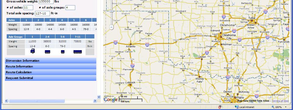
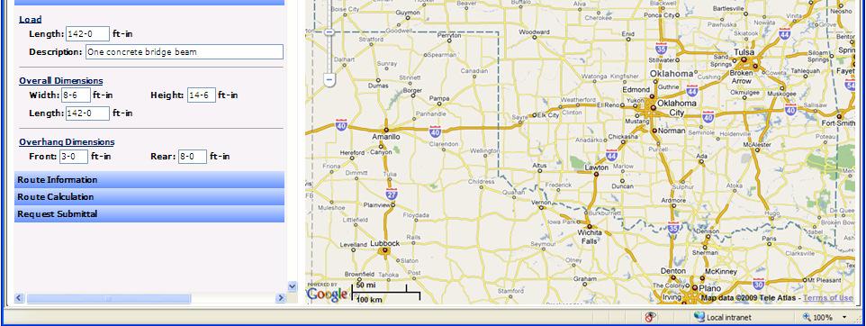
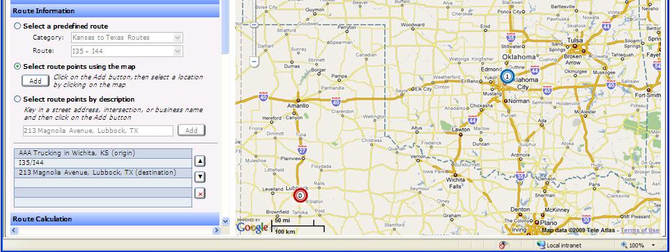
21 Requestor Information Permit Type Permit Information Vehicle Information Weight Information Dimension Information Route Information Route Calculation Shortest Valid Route O Get Route using: Interstates and States only Request Submittal 1 D
22 Find Location Locate by County Route Postmile County: Muskogee Route: 16 Milepost: 68 Find Locate by County Intersection County: Muskogee Route1: 16 Route2: 251A Find Edge Maintenance Turn Maintenance Temporary Closures Test Network Submit Edits
23 Find Location Edge Maintenance Select a route segment (edge) in the Map view to edit its properties. Click Done when finished editing this edge. Average Speed: 50 OneWay: Both One way-incr. ways One way-incr. # of Lanes: 4One way-decr. Min Lane Width: 11 Max Allow Weight: 16 Max Allow Height: 16 Max Allow Length: 16 Done Turn Maintenance Temporary Closures Test Network Submit Edits


24 Find Location Edge Maintenance Turn Maintenance Select the 2 edges that define the turn. Click Done when finished editing this turn. Restricted: Allowed Max Turn Radius: 90 ft. Restriction Type: Permanent Temporary From: To: Done Temporary Closures Test Network Submit Edits
25 Find Location Edge Maintenance Turn Maintenance Temporary Closures Click the From and To points for the closure. Type: Maintenance Curb to curb width: 48 ft. Restriction Dates: From: 8/3/09 To: 8/6/09 Done Test Network Submit Edits
26 Turn Maintenance Temporary Closures Test Network Test vehicle: Super-load Select a predefined route 2 Category: Test Routes Route: I35 I44 Select route points using the map Add Click on the Add button, then select a location by clicking on the map Select route points by description Key in a street address, intersection, or business name and then click on the Add button Add SR SR Get Route Submit Edits using: Interstates and States only 1
 SR 16 (66.5-68.")
27 Find Location Edge Maintenance Turn Maintenance Temporary Closures Test Network Your edits have been posted successfully. Submit Edits Select which edits to accept and then click Submit or click Discard to delete all edits. Location SR 16 ( ) SR 16 ( ) Edit Type 2 way to 1 way-incr Temporary lane closure Accept Submit Discard
28 Project Status Iterative project delivery methodology Iteration 2 Delivered Basic Permitting Application form complete Some business rules and data constraints accounted for Initial administrative functions Customer Account Management User Management Basic Routing (Point to Point) Iteration 3 Planned for May Further enhanced functionality Project completion scheduled for April 2011
29 Thank You! Questions?
The Benefits of Automated Permitting, Routing, and Bridge Analysis Systems
 The Benefits of Automated Permitting, Routing, and Bridge Analysis Systems A Bentley White Paper Meg Davis Senior Product Marketing Manager, Asset Performance Published: April 2019 www.bentley.com Introduction
Adaptation of HERS-ST Models for the South Carolina Interactive Interstate Management System
 Adaptation of HERS-ST Models for the South Carolina Interactive Interstate Management System presented to the Transportation Research Board HERS Modeling and Data Integration Conference presented by William
Managing Freight Mobility. Statewide Traffic Mobility Manager
 Managing Freight Mobility During Construction Randal Thomas Randal Thomas Statewide Traffic Mobility Manager Oregon s Statewide Traffic Mobility Program Presentation Topics Oregon Transportation Investment
Oversize/Overweight Permitting Practices Research Project
 Oversize/Overweight Permitting Practices Research Project Presented to: 13th Annual New Jersey Department of Transportation Research Showcase Presented by: Christopher Titze, AICP/PP, Cambridge Systematics
RAPID INCIDENT SCENE CLEARANCE (RISC)
") Approved: Effective: September 18, 2008 Traffic Engineering and Operations Topic No. 750-030-020-a RAPID INCIDENT SCENE CLEARANCE (RISC) PURPOSE: Rapid Incident Scene Clearance (RISC) is a highly innovative
Approved: Effective: September 18, 2008 Traffic Engineering and Operations Topic No. 750-030-020-a RAPID INCIDENT SCENE CLEARANCE (RISC) PURPOSE: Rapid Incident Scene Clearance (RISC) is a highly innovative
Emergency Harvest Permits with Route Authorizations
 Emergency Harvest Permits with Route Authorizations As in prior years, the State has declared an Emergency Harvest situation to run from September 10 th and continue through December 31 st of the current
APPENDIX N EXAMPLE REQUIREMENTS SPECIFICATION
 APPENDIX N EXAMPLE REQUIREMENTS SPECIFICATION Requirements Specification Automated Permit Routing and Analysis System (APRAS) Version: 1.1 Work Order 38: Task 3.1 Requirements Specification Prepared by:
RIDOT S Statewide Roadway and Asset Data Collection Project
 RIDOT S Statewide Roadway and Asset Data Collection Project ESRI User Conference 2017 Rafiq Basaria, DTS; Daniel Behnke DTS, Shane White, RIDOT Accent image here Primary Image here What is MIRE? Recommended
ODOT Transportation Systems Management & Operations Plan
 ODOT Plan Performance Measures Prepared for: Prepared by: May 2017 Updated December 2017 This page intentionally left blank Table of Contents List of Tables Introduction 1 ODOT s TSMO Performance Measures
INDUSTRY. Transportation
 INDUSTRY Transportation Solutions Keeping people and products moving safely and efficiently In a world of constant change, keeping people and products moving safely and efficiently is a complex, unrelenting
Data Driven Results: North Carolina s Strategic Prioritization Process through SPOT On!ine. NCDOT Strategic Prioritization Office April 4, 2016
 Data Driven Results: North Carolina s Strategic Prioritization Process through SPOT On!ine NCDOT Strategic Prioritization Office April 4, 2016 Agenda Why We Prioritize Background Strategic Investments
PennDOT s Road Closure Reporting System ( )
") PennDOT s Road Closure Reporting System ( ) Doug Tomlinson, P.E. PennDOT Bureau of Highway Safety and Traffic Engineering Nate Reck, Lead Developer GeoDecisions How RCRS Came About Originated by PennDOT
PennDOT s Road Closure Reporting System ( ) Doug Tomlinson, P.E. PennDOT Bureau of Highway Safety and Traffic Engineering Nate Reck, Lead Developer GeoDecisions How RCRS Came About Originated by PennDOT
APPENDIX A6: OPERATIONAL CONCEPTS BY SERVICE CATEGORY
 APPENDIX A6: OPERATIONAL CONCEPTS BY SERVICE CATEGORY Traffic Management Traveler Information Goods Movement Electronic Payment Toll Collection Fare Payment Public Transportation State-Level Archived Data
4.0 Method of Measurement. Measurement for Optional Temporary Pavement Marking will be made to the nearest linear foot.
 4.0 Method of Measurement. Measurement for Optional Temporary Pavement Marking will be made to the nearest linear foot. 5.0 Basis of Payment. Payment for OPTIONAL TEMPORARY PAVEMENT MARKING as described
Keeping people and products moving safely and efficiently
 Solutions for Transportation 2 Keeping people and products moving safely and efficiently In a world of constant change, keeping people and products moving safely and efficiently is a complex, unrelenting
Will County Community Friendly Freight Mobility Plan: Executive Committee Update
 Will County Community Friendly Freight Mobility Plan: Executive Committee Update April 6, 2017 A Public Private Partnership: Will County and the Will County Center for Economic Development CDM Smith is
Best Practices in Permitting Oversize and Overweight Vehicles. Final Report
 Best Practices in Permitting Oversize and Overweight Vehicles Final Report Notice This document is disseminated under the sponsorship of the U.S. Department of Transportation in the interest of information
Technical Memorandum. 720 SW Washington Suite 500 Portland, OR dksassociates.com. DATE: July 12, 2017
 Technical Memorandum DATE: July 12, 2017 TO: Kay Bork City of Veneta Bill Johnston, AICP Oregon Department of Transportation Christina McDaniel-Wilson, PE Oregon Department of Transportation Keith Blair,
FASTLANE Grant Project US-69 through Calera. Oklahoma Traffic Engineering Association 2017 Fall Meeting
 FASTLANE Grant Project US-69 through Calera Oklahoma Traffic Engineering Association 2017 Fall Meeting October 17, 2017 US-69 through Calera Project Location Town of Calera City of Durant Project Location
NCHRP 20-7 Guide to Benchmarking Operations Performance Measures Incident Duration - Pilot Test Results
 NCHRP 20-7 Guide to Benchmarking Operations Performance Measures Incident Duration - Pilot Test Results 4.2 Incident Duration As incident management systems are maturing in many metropolitan areas, incident
Wall Asset Management Implementation at Colorado Department of Transportation. Bryant Walters, Collins Engineers Mark Vessely, Shannon & Wilson
 Wall Asset Management Implementation at Colorado Department of Transportation Bryant Walters, Collins Engineers Mark Vessely, Shannon & Wilson Colorado DOT Wall Asset Management Program Development Coding
Office of Transportation Data (OTD)
") Office of Transportation Data (OTD) Paul Tanner State Transp o rtatio n D ata A d m inistrato r Presentation Objectives Why do we collect data? State & Federal Code Requirements Who collects the data?
Office of Transportation Data (OTD) Paul Tanner State Transp o rtatio n D ata A d m inistrato r Presentation Objectives Why do we collect data? State & Federal Code Requirements Who collects the data?
UNIT V TRAFFIC MANAGEMENT
 UNIT V TRAFFIC MANAGEMENT TRANSPORTATION SYSTEM MANAGEMENT Transportation System Management (TSM) is a package of short term measures to make the most productive and cost-effective use of existing transportation
APPENDIX A: SHORT-TERM PROJECT DEPLOYMENTS
 APPENDIX A: SHORT-TERM PROJECT DEPLOYMENTS Page 1 of 15 ST-01: I-95 ITS DEPLOYMENT (DE STATE LINE TO AIRPORT) PROJECT DESCRIPTION AND SCOPE: Project will address gaps in ITS device coverage on I-95 from
Examining the Economic Trade-offs of Alternative Transportation Funding NC I-95 Economic Assessment
 Examining the Economic Trade-offs of Alternative Transportation Funding NC I-95 Economic Assessment presented to ITED Conference presented by Cambridge Systematics, Inc. Paula Dowell, PhD April 2014 Background
DIVISION I TRAFFIC IMPACT STUDY GUIDELINES ENGINEERING STANDARDS
 CITY OF ALBANY DEPARTMENT OF PUBLIC WORKS DIVISION I TRAFFIC IMPACT STUDY GUIDELINES ENGINEERING STANDARDS Prepared By PUBLIC WORKS DEPARTMENT ALBANY, OREGON 97321 Telephone: (541) 917-7676 TABLE OF CONTENTS
Section 13. Guidelines for the Design of Ground Mounted Sign Supports
 Section 13 BDC11MR-04 13.1 Introduction Highway signs fall into two main categories, which are subdivided as follows: 1. Overhead Signs a. Sign Bridge Structures (GO) b. Sign Cantilever Structures (GO)
BMS2 Release Notes. Detailed BMS2 Release Notes. Release Version 5.13 (AMS Release 50)
") BMS2 Release Notes Detailed BMS2 Release Notes Release Version 5.13 (AMS Release 50) 1. Added BMS ID to the email notification detail pop-up in BMS2. 2. Bug requiring a user to delete the DOT AAR number
BMS2 Release Notes Detailed BMS2 Release Notes Release Version 5.13 (AMS Release 50) 1. Added BMS ID to the email notification detail pop-up in BMS2. 2. Bug requiring a user to delete the DOT AAR number
Building West Virginia DOT s Geospatial Capabilities:
 Building West Virginia DOT s Geospatial Capabilities: GIS Web Portal And Straight-line Diagram Application Current Status, Upcoming Enhancements, and Integration Marshall Burgess, WVDOT Don Kiel, GeoDecisions
One Maryland One Centerline. GIS-T 2014 May 7, 2014
 One Maryland One Centerline GIS-T 2014 May 7, 2014 Current Road Centerlines in Maryland SHA maintains a statewide centerline Supports HPMS program Represents state and local roads Capturing dual carriageways
Truck Parking Information Management System (TPIMS) Glossary
 Glossary") Truck Parking Information Management System (TPIMS) Glossary AASHTO American Association of State Highway and Transportation Officials is the organization that provides recommendations for a variety of
Truck Parking Information Management System (TPIMS) Glossary AASHTO American Association of State Highway and Transportation Officials is the organization that provides recommendations for a variety of
Gateway Cities Council of Governments Intelligent Transportation Systems Implementation Plan for Goods Movement
 Gateway Cities Council of Governments Intelligent Transportation Systems Implementation Plan for Goods Movement Streets and Freeways Subcommittee July 14, 2011 The Regional Problem Southeast Los Angeles
INDUSTRIAL/COMMERCIAL FACILITIES AIRPORT INTERSTATE BRIDGE MARINA
 Port of Hood River Providing for the region's economic future. INDUSTRIAL/COMMERCIAL FACILITIES AIRPORT INTERSTATE BRIDGE MARINA 1000 E. Port Marina Drive Hood River, OR 97031 (541) 386-1645 Fax: (541)
GEOMETRIC DESIGN CRITERIA for Non-freeway Resurfacing, Restoration, and Rehabilitation Projects
 GEOMETRIC DESIGN CRITERIA for Non-freeway Resurfacing, Restoration, and Rehabilitation Projects SEPTEMBER 1989 Arkansas State Highway and Transportation Department GEOMETRIC DESIGN CRITERIA for Non-freeway
2016 Mid-Continent Transportation Research Symposium, October 24-25, Donna Brown-Martin, Director Bureau of Planning and Economic Development
 2016 Mid-Continent Transportation Research Symposium, October 24-25, 2016 Donna Brown-Martin, Director Bureau of Planning and Economic Development Why the State Freight Plan is Important to You Vision,
Click to edit Master title style
 Click to edit Master title style Lessons Learned from ASCT and Systems Engineering Eddie Curtis, PE January 2016 1/26/2016 1 Opening Up Technology Deployment Life Cycle Research Technology Development
CHAPTER 3 SCOPE SUMMARY
 CHAPTER 3 SCOPE SUMMARY GENERAL The SDDOT is an active member of AASHTO to share common national design standards for the state highway system. The AASHTO Task Force on Geometric Design has completed the
Management. VA SITE Annual Meeting June 27, 2013 Jay Styles Performance and Strategic t Planning Manager, Business Transformation Office
 VDOT and MAP-21 Performance Management VA SITE Annual Meeting June 27, 2013 Jay Styles Performance and Strategic t Planning Manager, Business Transformation Office Overview Map-21- How is VDOT Preparing?
ATTACHMENT D. Open Roads Policy
 ATTACHMENT D Open Roads Policy DISTRICTWIDE SEVERE INCIDENT RESPONSE VEHICLE (SIRV) SERVICES Attachment C, Page 1 of 5 State of Florida OPEN ROADS POLICY AGREEMENT (Revised January 2014) Quick Clearance
High picking performance
 Scale your intralogistics. Vertical Buffer Module. Simple integration Energy efficiency High picking performance Intralogistics trends of the future What you need to be prepared for: Quickly expanding
Iowa Department of Transportation Intelligent Work Zone Deployments
 Iowa Department of Transportation Intelligent Work Zone Deployments SMARTER WORK ZONES TECHNOLOGY APPLICATIONS CASE STUDY The Every Day Counts Initiative (EDC-3) aims to accelerate the deployment of identified,
Transportation Management Plan
 Transportation Management Plan I 80 PE County, MP 51.38 to MP 62.49 One Inch Mill and Two Inch Fill With Open Grade July 2016 Prepared by Lisa Ouellette Nevada Department of Transportation Executive Summary
Special Events Planning
 Special Events Planning Prepared For: Prepared By: April 2010 Table of Contents 1.0 Overview... 1 2.0 Special Events Planning... 1 2.1 Impact of Planned Special Events... 1 2.2 Goals of Managing Travel
100 Design Controls and Exceptions
 100 Design Controls and Exceptions Table of Contents 100 Introduction... 1 101 Functional Classification... 1 101.1 General... 1 101.2 Urban & Rural... 1 101.3 Classification Used In ODOT Design Criteria...
FEDERAL HIGHWAY ADMINISTRATION RECORD OF DECISION FOR THE LYNNWOOD LINK EXTENSION
 FEDERAL HIGHWAY ADMINISTRATION RECORD OF DECISION FOR THE LYNNWOOD LINK EXTENSION AUGUST 2015 Table of Contents 1 Decision... 1 1.1 Project Description... 2 1.2 Basis for the FHWA Decision... 7 1.2.1
ACCOMMODATING OVERSIZE AND OVERWEIGHT LOADS: INSTRUCTOR AND STUDENT GUIDE
 ACCOMMODATING OVERSIZE AND OVERWEIGHT LOADS: INSTRUCTOR AND STUDENT GUIDE by Dan Middleton, P.E. Program Manager Yingfeng Li Assistant Research Scientist and Jerry Le Software Applications Developer II
AASHTO Transportation Safety Information Management System (TSIMS) Phase 1 Summary
 Phase 1 Summary") AASHTO Transportation Safety Information Management System (TSIMS) Phase 1 Summary Presented by: Hank Mycko Litton PRC, Manager of TSIMS System Architecture & Design TSIMS Goals Create a nationally recognized
AASHTO Transportation Safety Information Management System (TSIMS) Phase 1 Summary Presented by: Hank Mycko Litton PRC, Manager of TSIMS System Architecture & Design TSIMS Goals Create a nationally recognized
Joint Meeting- Stakeholder Committee & Technical Committee
 Joint Meeting- Stakeholder Committee & Technical Committee Wednesday, February 26, 2014 Cobb County DOT Squad Room Cobb County Comprehensive Transportation Plan Update 2040 www.cobbinmotion.com - Guiding
LOCATION AND DESIGN DIVISION
 VIRGINIA DEPARTMENT OF TRANSPORTATION LOCATION AND DESIGN DIVISION INSTRUCTIONAL AND INFORMATIONAL MEMORANDUM GENERAL SUBJECT: Design Exceptions / Waivers SPECIFIC SUBJECT: Design Exception Request Form
INTERSTATE CORRIDOR PLANNING
 INTERSTATE CORRIDOR PLANNING Prioritization of Corridor Studies July 29, 2015 Importance of the Interstate System Texas is an integral part of the national interstate system. The interstate system provides
Jobs & Transportation Ramping it Up Roadway and Traffic Dan Groh, P.E.
 Jobs & Transportation Ramping it Up Roadway and Traffic Dan Groh, P.E. Ohio DOT Work Zone Process Review Ohio DOT Work Zone Process Review This review was conducted by the Ohio Department of Transportation
4.11 TRAFFIC AND CIRCULATION
 4.11 4.11.1 ENVIRONMENTAL SETTING EXISTING TRAFFIC CONDITIONS Hyampom Road is the only all-weather access to the community of Hyampom, thereby making it the only school bus and mail route. It is also a
MINISTRY OF TRANSPORTATION AND INFRASTRUCTURE. REQUEST FOR INFORMATION TRANSPORT PERMIT SYSTEM RFI#MoTI-TPS
 MINISTRY OF TRANSPORTATION AND INFRASTRUCTURE REQUEST FOR INFORMATION TRANSPORT PERMIT SYSTEM RFI#MoTI-TPS-20150112 Issue date: January 12, 2015 Closing Date/Time: Responses must be received before 2:00
Creating Master Data Sets Build it once, use it a bunch
 Creating Master Data Sets Build it once, use it a bunch David Blackstone Office of Technical Services Dan Casey Chief Business Development Officer What When Why How Who What When Master Data Set Why How
A GIS Methodology to Map Routes from a Truck Permit Database Utilizing a Linear Reference System and Network Analysis
 Dayan et al. 0 0 0 0 0 A GIS Methodology to Map Routes from a Truck Permit Database Utilizing a Linear Reference System and Network Analysis Sinaya Dayan M.S. Geospatial Analyst Rahall Transportation Institute
Pennsylvania Public Private Transportation Partnership Board
 Pennsylvania Public Private Transportation Partnership Board Friday, September 27, 2013 511PA /Traveler Information System Request for Information (RFI) issued jointly by PennDOT & Pennsylvania Turnpike
Tracy Scriba, FHWA Work Zone Conference March 2009
 Crash Reduction Strategies for Work Zones Tracy Scriba, FHWA Work Zone Conference March 2009 Presentation Outline Work Zone Safety and Mobility Challenges Work Zone Crash Reduction Strategies ITS Effective
KANSAS WORK ZONE SAFETY AND MOBILITY PROCESSES AND PROCEDURES
 KANSAS WORK ZONE SAFETY AND MOBILITY PROCESSES AND PROCEDURES Bureau of Transportation Safety and Technology 700 SW Harrison, Topeka, KS 66603 July 30, 2008 Definitions Significant Project All Federal-aid
Developing Resilient Freight Systems
 Developing Resilient Freight Systems Barbara Ivanov Co-Director Freight Systems Division TRB 2011 Transportation Hazards and Security Summit August 23, 2011 How Can States Develop Resilient Freight Systems?
EXHIBIT A SCOPE OF SERVICES CONSULTANT SERVICES DISTRICTWIDE TRAFFIC SIGNAL RETIMING FINANCIAL PROJECT ID:
 EXHIBIT A SCOPE OF SERVICES CONSULTANT SERVICES DISTRICTWIDE TRAFFIC SIGNAL RETIMING FINANCIAL PROJECT ID: 22089863202 EXHIBIT A SCOPE OF SERVICES DISTRICTWIDE TRAFFIC SIGNAL RETIMING I. GENERAL REQUIREMENTS...
North Central Texas Council of Governments 157
 13. Transportation System Safety The goal of the Transportation System Safety Program Area is to improve transportation safety throughout the region by supporting planning efforts to develop safety policies,
SECTION TRAFFIC REGULATIONS
 PART 1 GENERAL 1.1 DESCRIPTION A. Traffic Control permits, notifications, mobilization, temporary signs, barriers, lights, flagging personnel, striping, markings, and demobilization and removal. 1.2 RELATED
Texas Model Border Crossing Project
 Briefing Document on Texas Model Border Crossing Project Prepared for Texas Department of Transportation by Center for Transportation Research University of Texas at Austin and Texas Transportation Institute
PROPOSED AMENDMENT OF THE I 76 INTEGRATED CORRIDOR MANAGEMENT PROJECT TO THE CONNECTIONS 2040 PLAN FOR GREATER PHILADELPHIA
 PROPOSED AMENDMENT OF THE I 76 INTEGRATED CORRIDOR MANAGEMENT PROJECT TO THE CONNECTIONS 2040 PLAN FOR GREATER PHILADELPHIA Background and Project Description In July 2013, the Delaware Valley Regional
Traffic/Mobility Analytics
 Daniel P. Farley Section Chief Traffic Operations Deployment and Maintenance dfarley@pa.gov 717-783-0333 How PennDOT is using large vehicle probe and crowd source information to begin to better plan, design,
TxDOT Internal Audit Texas Permit Routing Optimization System (1404-2) Department-wide Report
 Department-wide Report") Introduction Texas Permit Routing Optimization System (1404-2) Department-wide Report This report has been prepared for the Transportation Commission, TxDOT Administration and management. The report presents
Introduction Texas Permit Routing Optimization System (1404-2) Department-wide Report This report has been prepared for the Transportation Commission, TxDOT Administration and management. The report presents
Using Random Samples to Assess Roadway Condition. Faith Johnson GIS Specialist, NCDOT
 Using Random Samples to Assess Roadway Condition Faith Johnson GIS Specialist, NCDOT North Carolina Highway System 79,600 miles of state maintained roads Interstate: 1,326 Primary: 13,736 Secondary: 64,522
Puget Sound Regional ITS Architecture Update. Why does the region need an ITS Architecture?
 IBI GROUP 801 Second Avenue Suite 1400 Seattle WA 98104 USA tel 206 521 9091 fax 206 521 9095 ibigroup.com Memorandum To/Attention Puget Sound Regional Council Date May 26, 2015 (PSRC) From IBI Group Project
Safety Management System for Israel
 Safety Management System for Israel Dr. Simon Lewis and Joe Garvey AgileAssets, Inc. Traffic Records Forum New Orleans July 27, 2010 A nation under pressure * Do things well /smart * Do things right first
Between existing Interstate 70 in St. Louis, MO to west of the IL 203 Interchange on existing I-55/70 in Madison, IL
 American Association of State Highway and Transportation Officials An Application from the State Highway or Transportation Department of Illinois for: Elimination of a U.S. (Interstate) Route Establishment
State of Qatar ITS Architecture. Customized Service Package Diagrams. Advanced Traffic Management Systems (ATMS)
") State of Qatar ITS Architecture Customized Service Package Diagrams Advanced Systems (ATMS) ATMS01 - Network Surveillance traffic sensor control Ashghal Detectors traffic flow Use NTCIP for Cameras and
State of Qatar ITS Architecture Customized Service Package Diagrams Advanced Systems (ATMS) ATMS01 - Network Surveillance traffic sensor control Ashghal Detectors traffic flow Use NTCIP for Cameras and
WASHINGTON STATE TRANSPORTATION COMMISSION Mission, Roles and Responsibilities. Presentation to Eastside Transportation Association April 26, 2011
 WASHINGTON STATE TRANSPORTATION COMMISSION Mission, Roles and Responsibilities Presentation to Eastside Transportation Association April 26, 2011 Washington State Transportation Commission Seven members
Smarter Work Zones Paul Pisano FHWA Work Zone Management Team
 Smarter Work Zones Paul Pisano FHWA Work Zone Management Team National Rural ITS Conference Snowbird, UT August 2015 Efficiency through technology and collaboration Agenda Smarter Work Zones (SWZ) Overview
White Paper April 23, 2018
 White Paper April 23, 2018 BEST PRACTICES: COORDINATING WITH UNION PACIFIC IN ALTERNATIVE DELIVERY PROJECTS PURPOSE The purpose of this document is to recommend best practices for how public entities can
Chattanooga Regional ITS Architecture Update Workshop. September 24, 2013
 Chattanooga Regional ITS Architecture Update Workshop September 24, 2013 CHCNGA TPO Boundaries Presentation Overview Overview of ITS ITS Architecture Development Process Existing Regional ITS Architecture
EXHIBIT A SCOPE OF SERVICES FOR FINANCIAL PROJECT ID TRANSPORTATION SYSTEM MANAGEMENT & OPERATIONS (TSM&O) GENERAL CONSULTANT SERVICES
 GENERAL CONSULTANT SERVICES") EXHIBIT A SCOPE OF SERVICES FOR FINANCIAL PROJECT ID 432430-1-32-13 TRANSPORTATION SYSTEM MANAGEMENT & OPERATIONS (TSM&O) GENERAL CONSULTANT SERVICES DISTRICT TWO November 27, 2017 Page 1 EXHIBIT A SCOPE
EXHIBIT A SCOPE OF SERVICES FOR FINANCIAL PROJECT ID 432430-1-32-13 TRANSPORTATION SYSTEM MANAGEMENT & OPERATIONS (TSM&O) GENERAL CONSULTANT SERVICES DISTRICT TWO November 27, 2017 Page 1 EXHIBIT A SCOPE
Oklahoma Commercial Vehicle Information Systems (CVISN) Program Plan
 Program Plan") Oklahoma Commercial Vehicle Information Systems (CVISN) Program Plan Oklahoma Department of Transportation In Coordination With: U.S. Department of Transportation July 2003 Table of Contents Executive
Oklahoma Commercial Vehicle Information Systems (CVISN) Program Plan Oklahoma Department of Transportation In Coordination With: U.S. Department of Transportation July 2003 Table of Contents Executive
2017 Highway Safety Improvement Program Call
 2017 Highway Safety Improvement Program Call The Highway Safety Improvement Program (HSIP) is for highway safety projects that eliminate or reduce the number of fatalities and serious injuries on all public
TEXAS FREIGHT MOBILITY PLAN: DRAFT KEY POLICY RECOMMENDATIONS
 TEXAS FREIGHT MOBILITY PLAN: DRAFT KEY POLICY RECOMMENDATIONS Texas Freight Advisory Committee Midland August 14, 2014 Draft Key Policy Recommendations August 14, 2014 2014 Freight Mobility Plan Recommendations
BQE Atlantic to Sands Project Overview. 1. Project Background 2. Current Conditions & Findings 3. Upcoming Activities
 BQE Atlantic to Sands Project Overview 1. Project Background 2. Current Conditions & Findings 3. Upcoming Activities Commissioner Polly Trottenberg, New York City Department of Transportation June 29,
Updating Virginia s Statewide Functional. Brad Shelton, VDOT Chris Detmer, VDOT Ben Mannell, VDOT
 Updating Virginia s Statewide Functional Classification System Brad Shelton, VDOT Chris Detmer, VDOT Ben Mannell, VDOT July 18, 2013 What is Functional Classification Use of Functional Classification Today
eperformance Chapter 1. Primary reviewer completing the employee s appraisal
 eperformance Chapter 1. Primary reviewer completing the employee s appraisal This module will assist you in the technical aspect of preparing the performance appraisal with your employee. After you have
Smarter Work Zones Webinar Series
 Smarter Work Zones Webinar Series Webinar #12: Integrating Technology Applications Massachusetts DOT Todd Peterson and Neil Boudreau April 26, 2016 1:00-2:30pm EST Efficiency through technology and collaboration
HIGHWAY 14 NEW ULM TO NICOLLET 4-Lane Expansion Open House
 HIGHWAY 14 NEW ULM TO NICOLLET 4-Lane Expansion Open House HIGHLIGHTS OF HWY 14 PROGRESS 1960s & 70s Four-lane expansion in Rochester and Mankato areas 1993 Owatonna to Kasson EIS Completed (redone to
Recommended Roadway Plan Section 3 Existing Facilities & System Performance
 Recommended Roadway Plan Section 3 Existing Facilities & System Performance RECOMMENDED ROADWAY PLAN SECTION 3 Existing Facilities and System Performance 3.1 Introduction An important prerequisite to transportation
APPENDIX A: USER S MANUAL RSAP Version 3.0.0
 APPENDIX A: USER S MANUAL RSAP Version 3.0.0 N C H R P 22-27 ROADSIDE SAFETY ANALYSIS PROGRAM (RSAP) UPDATE RoadSafe LLC 12 Main Street Canton, Maine 04221 October 25, 2012 TABLE OF CONTENTS List of Figures...
OPEN DATA & PROJECT TRACKER. Michael Chamberlain TPP, Data Management
 OPEN DATA & PROJECT TRACKER Michael Chamberlain TPP, Data Management October 11, 017 Table of contents 1 People 3 Attributes 4 3 Locations 5 4 Systems 6 5 Reports 7-8 6 Applications 8-13 7 Closing 14 Data
Intelligent Transportation System - I
 Intelligent Transportation System - I Lecture Notes in Transportation Systems Engineering Prof. Tom V. Mathew Contents 1 Overview 2 2 Introduction 2 3 ITS user services 3 3.1 Travel and traffic management..........................
2.1 The Contractor shall furnish and maintain this system for measuring and delivering realtime messages for the work zone.
 Work Zone Intelligent Transportation System NJSP-15-32 1.0 General. The Work Zone Intelligent Transportation System (WZITS) shall be a portable, real-time, automated, solar powered system that calculates
Precast Concrete Pavement (R05)
") Precast Concrete Pavement (R05) 1 Agenda SHRP2 Overview What is SHRP2? Focus Areas Implementation Assistance Technical Product Description Product Implementation Implementation Timeline Questions Source:
Precast Concrete Pavement (R05) 1 Agenda SHRP2 Overview What is SHRP2? Focus Areas Implementation Assistance Technical Product Description Product Implementation Implementation Timeline Questions Source:
Incorporating Hauling Permits Into the RUMA Process
 Incorporating Hauling Permits Into the RUMA Process Background Section 4513.34 of the ORC (1) The director of transportation with respect to all highways that are a part of the state highway system and
Functional Requirements
 Missouri Department of Transportation Springfield Regional ITS Architecture Update Prepared for: Project ID: D8ITS-01 Missouri Department of Transportation Traffic Division MODOT DISTRICT 8 OFFICE M.O.
State Highway 10A Improvements (from the SH-10 junction extending 6.18 miles east to the SH-100 junction, Muskogee and Sequoyah Counties, Oklahoma)
") (from the SH-10 junction extending 6.18 miles east to the SH-100 junction, Muskogee and Sequoyah Counties, Oklahoma) Open House January 31, 2017 Open House Purpose Explain purpose and need for SH-10A improvements
(from the SH-10 junction extending 6.18 miles east to the SH-100 junction, Muskogee and Sequoyah Counties, Oklahoma) Open House January 31, 2017 Open House Purpose Explain purpose and need for SH-10A improvements
RIDOT S Statewide Roadway and Asset Data Collection Project
 RIDOT S Statewide Roadway and Asset Data Collection Project GIS-T Conference 2017 Shane White Rhode Island DOT; Daniel Behnke DTS Accent image here Primary Image here RDIP Technical Assistance Started
Enhanced Analysis of Work Zone Safety through Integration of Statewide Crash Data with Lane Closure System Data
 Cheng, Parker, Ran and Noyce 0 0 0 0 Enhanced Analysis of Work Zone Safety through Integration of Statewide Crash Data with Lane Closure System Data Yang Cheng, Ph.D. Research Associate Department of Civil
Benefit Cost Analysis Narrative
 Chicago Region Environmental and Transportation Efficiency Program (CREATE) Grade Separations of: GS21a - Union Pacific and 95 th Street GS11 - Belt Railway Company of Chicago and Columbus Ave. GS 9 -
Oversize/Overweight Permitting Practices Review. FINAL REPORT October Submitted by
 NJ-2011-002 Oversize/Overweight Permitting Practices Review FINAL REPORT October 2011 Submitted by Christopher Titze Cambridge Systematics, Inc. New York, NY 10016 NJDOT Research Project Manager Priscilla
New Jersey Turnpike Authority
 New Jersey Turnpike Authority DOCUMENT UPDATE REQUEST Forward to Assistant Chief Engineer, Design Initiator Russell Saputo, PE Submittal Date 6/21/16 Firm Stantec Consulting Services Inc. Telephone 201-587-9040
Florida Department of Transportation 605 Suwannee Street Tallahassee, FL
 RICK SCOTT GOVERNOR Florida Department of Transportation 605 Suwannee Street Tallahassee, FL 32399-0450 MIKE DEW SECRETARY REQUEST FOR INFORMATION (RFI) from the Florida Department of Transportation INTRODUCTION
Introduction. Minnesota Trucking Regulations
 Introduction Minnesota Trucking Regulations 1 Introduction Motor carrier regulations can be complex. Your responsibilities extend beyond your business operations to the condition of your vehicles and the