Planning Assumptions Technical Memorandum
|
|
|
- Ada Blake
- 6 years ago
- Views:
Transcription
1 Planning Assumptions Technical Memorandum This project has been developed in compliance with Title VI of the Civil Rights Act of 1964 and other federal and state nondiscrimination authorities. Neither FDOT nor this project will deny the benefits of, exclude from participation in, or subject to discrimination to anyone on the basis of race, color, national origin, age, sex, disability, or family status. January 2013
2 Pinellas Transportation Plan Planning Assumptions 3 Major Findings and Trends 5 Document Review 5 Agency Interviews and Surveys 6 Emerging Issues 7 Major Road Capacity Projects 9 Land Use Strategy 9 Revenue Projections 10 Cost Projections 12 Transportation Safety 12 Public Transportation 12 Bicycle and Pedestrian Facilities 14 Socio Economic Data 15 Goods Movement 18 Congestion Management 19 Availability of Land 19 Constrained Roads 19 Beach Communities 20 Regional Travel 21 Non Traditional Vehicles 21 Constrained Corridors Map 23 Attachment A: Notes from Agency Interviews Attachment B: Completed Agency Survey Forms January 2013 Page 2
3 Pinellas Transportation Plan January 2013 Page 3


4 Pinellas Transportation Plan Planning Assumptions Roads The Metropolitan Planning Organization s (MPO s) main priorities for investment will be the remaining partially controlled access facilities (including U.S. Highway 19, Gandy Blvd, and the CR 296 Connector (Future SR 690)), maintenance of the existing transportation system, improving the operations of the existing transportation system, and transit, bicycle and pedestrian improvements. Some roadway capacity projects identified in the 2035 Long Range Transportation Plan (LRTP) and the capacity of certain existing roadways will be reconsidered to determine compatibility with the surrounding community and other community goals. On certain corridors, consideration will be given to roadway treatments such as complete streets and road diets. The Congestion Management Process (CMP) will become increasingly important as the roadway network becomes built out and funding for major improvements declines. The CMP will be utilized to identify improvements to maximize the operational efficiency of the roadway network. In the LRTP, roadways identified as Constrained will be deficient in the future, even when planned projects are completed. These roadways will not be further widened beyond planned improvements and a certain level of congestion on the corridors will be accepted. These corridors will be analyzed for transit accommodations, operational improvements and other non capacity enhancements. Transit Transit service will continue to be evaluated as a way to meet various local and regional travel needs. Given the unique circumstances of each community, consideration will be given to flex service, bus rapid transit, express bus, expanded trolley service, circulators and the Locally Preferred Alternative, as identified through the Pinellas Alternatives Analysis (AA) and through the Pinellas Community Bus Plan. The average population of Pinellas County is getting older and household sizes are getting smaller. As older populations are unable to or choose to discontinue use of private automobiles, more mobility options will be necessary. Meanwhile, recent trends nationwide are showing that younger generations are increasingly turning to transit for their everyday transportation needs. In order to attract and retain younger residents and support the local economy, the benefits of investments in transit will need to be considered. January 2013 Page 4
5 Pinellas Transportation Plan The MPO recognizes that many residents and visitors, regardless of age, desire a variety of travel options and will work with its partners to design a transportation system that serves the needs of all segments of the population. Other Modes Bicycle and pedestrian facilities will be incorporated into all road projects, where feasible, and where needed to provide access to premium transit services. Connectivity amongst modes will be taken into consideration in the design of all transportation projects. The completion of the Pinellas Trail Loop and east/west connecting facilities will remain a high priority. Strategies to address crashes involving bicycles and pedestrians will be analyzed, including those targeting education and enforcement. Revenues Gas tax revenues available for transportation projects will continue to decline with the diminishing purchasing power of the revenues and increased vehicle fuel economy. Additional funding for transportation could be secured in Pinellas County through the passage of the Charter County and Regional Transportation System Surtax (Transportation Surtax), providing revenues for greater transportation investments, including significant transit improvements. The MPO will work closely with the Florida Department of Transportation (FDOT), Pinellas Suncoast Transit Authority (PSTA), and the local governments to identify and estimate available revenues for the LRTP update. Revenue from the Penny for Pinellas is projected to increase 3% annually going forward. Discussion will continue regarding local revenues available for transportation projects through the year Demographics Without a significant change in the land use pattern, the permanent population of Pinellas County is projected to increase by small amounts each year from now until 2040, with a large portion of the gain coming through higher density redevelopment. The development of a light rail transit system has the potential to have a significant impact on land use patterns, particularly around station areas, and provide for more substantial population increases. The MPO will analyze this through the scenario planning process. Similar to population growth, without a significant change in the land use pattern to draw new residents, the number of jobs in Pinellas County will grow at small amounts annually until 2040, providing employment opportunities for the growing county population and for the region as a whole. The development of a light rail transit system has the potential to provide for more employment growth opportunities, attracting new residents to expand the local labor force and by spurring investment and redevelopment. The MPO will analyze this through the scenario planning process. School enrollment will continue to decline in the next few years, although not by as many students as had occurred in the past decade. After that, incremental increases in school enrollment are expected. The major industrial businesses in the county are anticipated to remain concentrated in the freight activity centers, particularly in the Gateway area. The MPO will continue to monitor the needs of the freight community and make sure the transportation network is responsive to January 2013 Page 5
6 Pinellas Transportation Plan those needs. All projects along identified truck routes and serving industrial areas will take freight movements into account. Major Findings and Trends Document Review In order to identify the major trends affecting the development of the LRTP, completed studies were reviewed in an effort to identify any recurring themes or data trends. These findings and trends were identified through a document review as well as through interviews with members of the local planning, housing and economic development departments, and from information gathered from other local agency representatives. The findings from the document review were considered in the development of this document. Documents Reviewed Include: Local government comprehensive plans Pinellas County MPO 2035 Long Range Transportation Plan Pinellas Alternatives Analysis Pinellas County 2011 Economic Profile, Pinellas County Economic Development Pinellas Planning Council Countywide Plan 2010 State of the System Report 2000 and 2010 Census Data St. Petersburg Vision 2020 and Vision 2020 Special Area Plan City of Largo Strategic Plan Largo Downtown Multi Modal Plan Largo Economic Development Strategic Plan Dunedin 2005 Vision Dunedin Corridor Studies Tarpon Springs Multimodal District Clearwater Economic Development Strategic Plan Clearwater Downtown Plan Clearwater Greenprint Target Employment and Industrial Lands Study for the Pinellas Community PSTA TDP 2011 Tampa Bay Regional Scorecard, Tampa Bay Partnership MPOAC Revenue Study Pinellas By Design TBARTA Master Plan 2060 Florida Transportation Plan Gateway Areawide Plan Gulf Blvd. Studies/Plans Pedestrian Safety Action Plan 2006 Clearwater Evaluation and Appraisal Report January 2013 Page 6
7 Pinellas Transportation Plan Agency Interviews and Survey Interviews Interviews were held with representatives from economic development, transportation and planning departments from the county and selected cities. The cities were selected for interviews in order to obtain a representative response from the many distinct communities throughout Pinellas County. The following is a list of those that participated in the agency interviews: City of Clearwater: Gina Clayton, Lauren Matzke City of Dunedin: Greg Rice, Joan Rice, Tom Burke City of Indian Rocks Beach: Danny Taylor City of Largo: Carol Stricklin, Robert Klute, Leland Dicus City of Oldsmar: Marie Daupinais, Michele Parisano City of Pinellas Park: Robert Bray City of Seminole: Mark Ely City of St. Petersburg: David Goodwin, Derek Kilborn, Rick MacAuley, Tom Whalen, Joe Kubicki City of Tarpon Springs: Renea Vincent, Rodney Chatman Pinellas County: Larry Arrington, Gordon Beardslee, Elizabeth Freeman, Ivan Fernandez, Armanda Lampley, Cindy Margiotta, John Cueva, Al Bartolotta As Pinellas County is made up of 25 different jurisdictions (24 municipalities and the county), transportation priorities and issues are varied and unique to each community. Each community has its own vision of what its future will be like and with that, an understanding of the transportation improvements necessary to attain that vision. MPO staff met with each of the participating agency representatives to help to get an understanding of what the transportation issues and priorities were in various parts of the county. The MPO understands that there is no one size fits all approach to transportation and that any improvements or changes to the transportation network need to be coordinated with the local agencies to ensure they balance the needs of the overall transportation system with the goals of the surrounding community. While the transportation issues brought up by the various jurisdictions were wide ranging, a common theme that resonated during the interviews was that connectivity was a high priority. All jurisdictions noted the importance of bicycle and pedestrian accommodations for their residents and expressed a desire to improve the connections between these facilities and residential and commercial areas. However, some communities did not highlight the provision of such facilities within neighborhoods as a priority. In addition, some of the local governments are looking to develop and implement Complete Streets policies that take all modes into consideration during roadway design, and do not just target automobiles. Most local governments interviewed also mentioned the importance of transit service for their communities. The idea of express bus service along major corridors with local circulator service was brought up by several of the interviewed local governments as transit service that they would like to see in their communities. On the other hand, one local government noted that the transit priority was to January 2013 Page 7
8 Pinellas Transportation Plan bring workers into the city in the morning and out of the city in the evenings, with little need for local circulator service. The communities along the corridor identified in the Pinellas Alternatives Analysis discussed the potential positive impacts that a light rail line could have on their communities, with increased transportation options and the development potential around station areas. Each interviewed local government shared with MPO staff the approximate types and locations for future redevelopment in their communities and discussed with staff potential transportation impacts that such future development may have on the overall transportation system. Each interview also included a recommended list of documents that the MPO should review to get a better idea of how and where each local government was planning to grow. In addition, each community identified locations with transportation issues within their borders that they considered priorities for the MPO to consider during the development of the 2040 LRTP. Notes from each meeting with the local governments are included as an attachment to this document. Surveys Surveys were supplied to members of the MPO s Technical Coordinating Committee. Survey results were utilized to help inform the development of the Planning Assumptions and helped MPO staff gather an understanding of the transportation issues at the local level. Completed surveys are attached to this document. The questions posed by the survey are listed below. Survey Questions: 1. What are the priority transportation mobility issues in your community that need to be addressed by the MPO s Long Range Transportation Plan? 2. What redevelopment, economic or demographic trends do you see having the greatest influence on Pinellas County s transportation system in the future? 3. How can transportation investments better support economic growth and opportunity in the community? 4. What are the transportation projects or strategies that would most support your agency s or community s objectives? 5. In terms of funding of transportation needs, how could the MPO better direct its priorities to support your agency or community s objectives? 6. Do you have any additional thoughts or guidance concerning the LRTP update? 7. What planning challenges are you facing in your community? Emerging Issues Climate Change/Sustainability Legislation was passed at the federal level and in Florida encouraging each MPO to consider strategies that integrate transportation and land use planning in their LRTP to provide for sustainable development and reduce greenhouse gas emissions, as well as include energy considerations in all state, regional and local planning. The LRTP update will include discussion regarding the integration of transportation and January 2013 Page 8
9 Pinellas Transportation Plan land use strategies to encourage sustainability. In addition, goals, objectives and policies discussing climate change and sustainability concepts will also be developed. Performance Measures The new federal surface transportation legislation, Moving Ahead for Progress in the 21 st Century (MAP 21) includes requirements that MPOs use a performance based approach to transportation planning. MPOs must set performance targets, in coordination with states and public transportation agencies, for each of national goals outlined in the legislation. The LRTP must include a description of the MPO s performance measures and targets, and a system performance report evaluating the condition and performance of the transportation system with respect to the performance targets. The MPO will work with the state, PSTA, and the MPO advisory committees to develop the performance measures and targets and integrate them into the LRTP. Sustainable Transportation and Context Sensitive Solutions MPOs are encouraged to identify and suggest contextual solutions for appropriate transportation corridors. For example, Context Sensitive Solutions (CSS) may be appropriate for historic parkways, historic districts, town centers, dense walkable neighborhood areas or simply where right of way is not readily available. The value of resources present may suggest the need for alternative or special treatments (or even accepting a level of congestion and lower speeds that respects the resources). In these instances, specific livability principles might be employed for improved pedestrian and transit access especially to schools and even traffic calming. Also, spatial relationships that support public transit like transit oriented development and the trip not taken while reducing greenhouse gases might be recognized as characteristics of a town center or mixed use area with public transit access. Other livability planning goals might need to be recognized like preserving affordable housing, improving/preserving special resources like parks, monuments and tourism areas, increasing floor area ratios and reducing parking minimums in select corridors to encourage walking trips and public transit, transportation demand management, etc. Pinellas MPO will be considering CSS strategies throughout the development of the next LRTP and will evaluate how to best integrate into the LRTP. Scenario Planning MPOs are encouraged to use the tools and techniques that are collectively called scenario planning. Scenarios are narratives or sets of assumptions that explore plausible trajectories of change and provide a means of visioning possible future changes and different policy and investment options. The key elements in scenario planning include the use of scenarios to compare and contrast interactions between multiple factors, such as transportation, land use, and economic development; analysis of how different land use, demographic, or other types of scenarios could impact transportation networks; identification of possible strategies that lead a community, region, or study area toward achieving elements of the preferred future; and emphasizes public stakeholder involvement throughout the process to help create options (scenarios) and assess outcomes. The Pinellas MPO will be embarking on a scenario planning effort with the development of the 2040 LRTP, including an assessment of a trend scenario, a scenario with increased investments in bus transit and highway networks, and a scenario that includes investments in bus transit, highway networks and a light rail transit system. January 2013 Page 9

10 Pinellas Transportation Plan Freight The importance of freight to the nation s economic well being and global competitiveness, as well as its support and promotion of job creation and retention has heightened its status at the national and regional level. With the passage of MAP 21, the planning focus on freight transportation has increased, and is included as one of seven national goals. In addition to its importance at the national level, the movement of freight is a priority at the local level as well. The MPO will continue to monitor the priorities of the local governments and the planning requirements that have come out of the new federal transportation bill so that freight transportation receives the full attention it requires in the next LRTP update. Major Road Capacity Projects Moving forward with the next LRTP update, it is assumed that the MPO will continue to pursue the remaining major capacity and partially controlled access facility projects on Roosevelt Blvd., Ulmerton Rd., the CR 296 Connector, Gandy Blvd., and U.S. Highway 19. Given the built out nature of the major road network, the MPO will be working to identify operational improvements, transit, and other strategies to maximize the capacity of the existing roadway network. Beyond the roadways listed above, there are very few opportunities to expand capacity on existing roadway corridors, and even fewer opportunities to construct more roads. Some of the local governments interviewed as part of this effort expressed a desire to provide for more Complete Streets that accommodate alternatives to the single occupancy vehicle and improve operational efficiency without adding more lanes. Many of the agencies interviewed also listed specific locations where there were transportation issues and recommended solutions to those problems. The MPO will continue working with the local jurisdictions to see how the LRTP can support the transportation needs of the local governments and help to remedy the problems identified both through this process and going forward. While evaluating the need for transportation projects, the cost to operate and maintain these facilities needs to be closely considered. The long term costs associated with transportation investments need to be taken into consideration and provided to all parties, including the general public, so that everyone is well informed of the details needed in order to make the best decision for the entire community. Land Use Strategy This update of the LRTP is an opportunity to further integrate transportation and land use. Our transportation system needs to be responsive to the needs of the community and the region, and planning for that system must take consider the desired future direction of the community. As little January 2013 Page 10

11 Pinellas Transportation Plan additional roadway capacity will be built, alternative modes of transportation are needed to accommodate additional growth, and the land use strategy employed by the local governments should reflect that. Countywide transportation and land use planning efforts are being re envisioned simultaneously so that they support one another. The MPO will be working closely with the local countywide land use agency, the Pinellas Planning Council (PPC), and the local governments so that projects and programs incorporated into the LRTP support future land use planning priorities. In a community such as ours, with little vacant developable land, the highest densities and intensities should be concentrated in areas with current or planned access to transit. Some of the municipalities, the county and the PPC have developed station area typologies to help guide development decisions around future premium transit stations. These typologies will provide the framework to direct an appropriate level of transit oriented development to station areas, and will help to provide the demand and ridership to support a premium transit system. Revenue Projections With the nationwide economic decline and stagnation in recent years, revenues available for transportation projects and programs at the local, state and federal level have significantly decreased. Gas tax revenues that are available for transportation projects are declining as the tax rates are a fixed amount (not a percentage of the cost of a gallon of gas) and are not tied to inflation. Economic stagnation that has taken cars off of the road, increases in the fuel economy of all vehicles, and the decreasing purchasing power of the gas tax, have resulted in further decreases in the revenues available from the gas tax. It is not anticipated that the gas tax will be increased or otherwise adjusted to increase the amount of revenue collected from it. With increasing fuel economy standards being phased in starting in 2017, it is assumed that revenues from the gas tax will continue to decline, and the purchasing power of the revenues that are collected will be further diminished due to inflation. In May 2012, the Congressional Budget Office (CBO) released a brief titled How Would Proposed Fuel Economy Standards Affect the Highway Trust Fund. In this brief, the CBO estimates that the proposed fuel standards would gradually reduce gas tax revenues, eventually by 21 percent. The CBO reports that the full effect would not be seen until 2040, the end year of the LRTP update. Decreases are estimated to result in a $57 billion decline in revenues credited to the Highway Trust Fund over the 11 year period from This decrease in revenues available for transportation projects will have an impact on funding available for transportation improvements in Pinellas County and the MPO will need to adjust its planning accordingly. January 2013 Page 11
12 Pinellas Transportation Plan PSTA receives the majority of its funding through local property tax collections and federal grants. Farebox revenues account for approximately 23% of the agency s budget, which is above the national farebox recovery rate of 18 20%. Ridership has increased in recent years, leading to an increase in the revenue available from the farebox (a 24% increase from FY2007 to FY2012). IN FY2012, property tax collections comprised 54% of PSTA revenues. However, with decreased property values, the amount PSTA collects for transit service through the ad valorem tax has declined significantly (more than a 10% decline from FY2007 to FY2012 despite a millage increase from.5601 to.7305 in 2011). County budget forecasters are anticipating continued reductions in taxable property values through 2014, with a 2% increase in 2015 and a 4% increase annually from 2016 through Under current economic conditions, PSTA is operating in an environment wheree no significant growth in the system is possible and existing revenue streams will not keep up with rising operating costs. With economic recovery, it is anticipated that PSTA will soon begin to recover some of the revenue lost from declining ad valorem taxes, but it will likely take a number of years. Should Pinellas County voters approve a Transportation Surtax referendum, PSTA would cease collection of its ad valorem taxes and rely primarily upon both farebox and the sales tax collections for its local funding. Restructuring PSTA s funding in that way would provide more revenue than is currently collected and would allow the agency to significantly enhance existing transit service. An option discussed for increasing revenue for transportation projects has been the Charter County and Regional Transportation System Surtax (Transportation Surtax), a local option sales tax, which would need to be approved by voter referendum and can be implemented at a rate of up to 1%. The revenue from the Transportation Surtax would primarily fund transit projects, but up to 25% of revenues would be available for investments in other modes, including roads, sidewalks and bike path/ /lane projects. The revenue percentages that would be available for the various modes are still undetermined and the discussion regarding these details will continue. Without the Transportation Surtax, it is anticipated that the funding available for transportation projects will continue to decline and that low cost January 2013 Page 12


13 Pinellas Transportation Plan improvements that focus on the efficient operation of the existing system will take on a greater role in the improvement of the local transportation system. At the local level, recent economic conditions have led to decreased gas tax, sales tax and property tax revenue funds available for transportation improvements. The Penny for Pinellas is a 1% sales tax distributed amongst all local governments in Pinellas County for capital projects. The Penny for Pinellas is approved by voters for a ten year period, with the current Penny for Pinellas continuing until With the economicc conditions of recent years, the current Penny for Pinellas has brought in less revenue than originally anticipated, thereby reducing revenues available for transportation projects. However, sales tax revenues have increased recently, with a 3% annual increase anticipated each year from 2013 and on. This will be factored into the estimation of available revenues for transportation improvements with the 2040 LRTP. As a part of the LRTP update, the MPO will work with the local governments, FDOT, and PSTA to develop comprehensive revenue projections to cover the time period included in the 2040 LRTP. These projections will help determine what transportation projects the MPO can reasonably expect to be able to fund through Cost Projections The MPO will work closely with FDOT, PSTA, the County and the other local governments to estimate project cost projections through the outer years of the LRTP. The cost projections for projects included in the Cost Feasible Plan of the LRTP will be shown in Year of Expenditure dollars. Transportation Safety The safety of the transportation system has long been a priority of the MPO. While improvements have been made in reducing the crash rate, the rate of fatal and incapacitating crashes in Pinellas County continues to be high, especially amongst bicyclists and pedestrians. During the development of the LRTP, the safety of the transportation system will continue to be taken into consideration and all projects will be analyzed to ensure that the safety of all userss is addressed. Public Transportation Pinellas County is a community with very little vacant and developable land. This also means that there is little room left for roadway capacity projects; with the completion of capacity projects in the Gateway area and improvements to US 19, the county s major road network will be substantially complete. In order to accommodate future growth in the county, there will need to be an efficient transit system in January 2013 Page 13
14 Pinellas Transportation Plan place to absorb trips and ensure the reliability of the existing roadway system, to avoid causing significant delays and negatively impacting residents and businesses. Significant investment in a premium transit system is needed in order to accommodate growth and economic development in the county as little additional capacity will be added to the roadway network. Many local governments in the county have expressed interest in increased transit service in their communities to relieve congestion and provide transportation options for their residents and visitors. Recent trends indicate that younger people are showing more of an interest in living in urban environments, foregoing or delaying vehicle purchases and opting instead to use transit. The development of a premium transit system in Pinellas County could be an element in enticing workers to either remain in or move to the area. In light of the aging population in Pinellas County, attracting and retaining younger residents could provide for a more diversified workforce to serve existing businesses and those businesses considering locating here. Station areas serving premium transit routes often spur redevelopment, creating new and more diversified housing types, thus helping to revitalize communities. The MPO will work closely with PSTA during the LRTP update to analyze the existing transit system and determine where and how improvements can be made to better serve the county and its residents. Access to transit was identified in the Industrial Lands Study as an issue that is important for Pinellas County to meet its goals for job growth. The MPO will remain cognizant of this as the LRTP is updated. Additionally, the demand for late night and weekend bus service for those employed in the service sector is increasing, and will be taken into consideration during the development of the LRTP and through the Pinellas Community Bus Plan. The Pinellas Alternatives Analysis (AA) study was looked at the potential for premium transit service in Pinellas County and was completed recently with the endorsement of a Locally Preferred Alternative (LPA). The LPA includes a light rail system in exclusive guideway connecting St. Petersburg, Pinellas Park, Greater Gateway, Largo and Clearwater, with a regional connection across Tampa Bay to Hillsborough County. The light rail system is anticipated to serve more than 24,000 riders daily, relieving congestion on surface roads and absorbing trips generated by future development along the transit corridor. The LPA also identifies 16 potential stations and includes countywide service enhancements to support its operation. Most of the local governments served by the transit corridor and the Pinellas Planning Council have developed station area typologies to help to guide development decisions around station areas. These typologies will serve to ensure that an appropriate level of transit oriented development is directed to station areas, and will help to provide the demand and ridership to support the system into the future. The ability to construct the premium transit system identified by the LPA will depend on the ability of the county to secure additional funding. As discussed earlier, there is consideration being given to holding a referendum on the Transportation Surtax, a sales tax levied at a rate of up to one percent, the proceeds of which would be utilized for transportation improvements, including the construction and operation of a light rail system and significant new investments in the bus system countywide. January 2013 Page 14

15 Pinellas Transportation Plan PSTA is currently implementing a North County Flex Service. This service will offer passengers the option of calling for a ride on the route deviation service or picking up the Flex vehicle at one of its regularly scheduled Flex stops along the selected corridor. The Flex vehicle is a 16 passenger vehicle with space for two wheelchairs and travels within Flex zones in East Lake, Palm Harbor, and Tarpon Springs. This service is anticipated to be less expensive than fixed route service as it can meet specific customer needs with fewer hours or miles of service. PSTA continues to offer a trolley service along the beaches and has recently extended this service to connect with the broader community. The trolley on St. Pete Beach now travels into downtown St. Petersburg to the Pier, providing another transportation option for visitors who would like to visit attractions off of the beach, and also serves commuters who work on the beaches but live on the mainland. The implementation of the North County Jolley Trolley has proven to be very popular, connecting Clearwater Beach, Dunedin, Palm Harbor and Tarpon Springs. This service has brought visitors from the beach to destinations and businesses in North County and also provides another option for commuters by linking with the broader PSTA network. PSTA is also currently working on the Pinellas Community Bus Plan to outline how the PSTA Bus System can be transformed into a new network of transit services that best benefits the future needs of the community. This study is scheduled to be completed by mid The MPO will incorporate recommendations from the Bus Plan into the 2040 LRTP. The public transportation system in Pinellas County is continuously evolving to meet the needs of residents and visitors, while making adjustments to deal with declining revenues due to economic retraction. As previously discussed, if PSTA continues to rely on ad valorem revenues for its funding, it is anticipated that service will need to be adjusted in the next few years to deal with continued revenue decreases. If the voters approve a referendum for Transportation Surtax, revenues may increase for PSTA, which will then be able to provide additional public transportation services. Bicycle and Pedestrian Facilities A common theme in the planning documents of the various local governments in Pinellas County is that pedestrian and bicycle connections should be provided whenever possible. Quality bicycle and pedestrian facilities that provide connections to where people live, work and play will remain a high priority for the MPO. January 2013 Page 15


16 Pinellas Transportation Plan The MPO will maintain its policy of including bicycle facilities on every road construction and resurfacing project. In addition, the completion of the Pinellas Trail Loop will remain a high priority for the MPO and as the funds to finish the project become available, they will be allocated accordingly. New and replacement pedestrian facilities will be prioritized accordingly, with the proximity to school facilities, location along major roadways, ability to fill in existing gaps, and linkages to future premium transit stations being taken into consideration in the prioritization process. With a decrease in the provision of busing for school children, increased emphasis will be placed on the safety of students walking or biking to school. In addition, some communities are experiencing a growth in the number of people commuting by bicycle. Designs for roads and transit accommodations need to take users of bicycle facilities into account, to ensuree that the transportation system accommodates all users. With less of a focus on capacity projects, the LRTP update will exploree improvements in multimodal connectivity throughout the county to offer transportation alternatives to residents, support community development goals, and to increase the safety of bicyclists and pedestrians utilizing the roadway network. An update to the Pinellas County Bicycle/Pedestrian Master Plan is currently underway and will evaluate gaps, connectivity issues and safety problems related to bicycle and pedestrian facilities. The results of this study will be incorporated into the LRTP. Socioeconomic Data Population and Demographics With the release of data from the 2010 Census, it is clear that Pinellas County has lost population since The economy appears to be stabilizing, however, and it is projected that there will be gradual, but small, increases in the population between now and 2040, without any significant changes to the land use pattern or policies. With little vacant/developable land, many of the opportunities for population growth in Pinellas County will come from higherspecific density redevelopment focused in and appropriate areas of the county. The development of a light rail transit system would create even more opportunities for redevelopment in the county, spurring additional population growth. January 2013 Page 16
17 Pinellas Transportation Plan From 2000 to 2010, the median age in Pinellas County rose from 43 to This compares with a nationwide median age of The average household size decreased slightly from 2.17 to 2.16, compared with a nationwide average household size of This data is indicative of the large number of retirees that call Pinellas County home. As our residents age, they may be less willing and able to take a personal vehicle for their daily transportation needs. The needs of the older populations will be considered in the further development of the transportation system. A transit and para transit system that can serve the needs of an aging population can provide a crucial link that these residents need in order to be able to remain active in their communities and also to remain in their homes. In addition to serving the older residents of the county, the transportation system needs to work for younger generations as well. As previously mentioned, recent trends are showing that the younger generations are locating in urban areas where they can avoid driving for their everyday needs and instead take public transportation. The transportation system of Pinellas County will need to be able to compete with other major metropolitan areas and provide the transportation options that the younger generations are looking for. Without a premium transit system, Pinellas County may have a difficult time retaining and attracting younger residents, which may have an impact on the local labor force and economy. MPO staff is identifying areas in Pinellas County with high concentrations of minority and low income populations. These groups are considered to be traditionally underserved and MPO staff will be targeting outreach activities in these areas to ensure that underserved groups are involved in the process to update the LRTP. In addition, Environmental Justice regulations require that these groups are not disproportionally burdened by the impacts of transportation projects and also that they are not denied the benefits of transportation investments. Areas with high concentrations of these populations will be mapped and compared to planned transportation projects to ensure that the costs and benefits of transportation improvements are distributed equally amongst all populations in Pinellas County. Demographically, from 2000 to 2010, Pinellas County experienced an overall decline in the total population, equal to approximately 0.5%, while the minority population, as a percentage of the total county population, increased by over 35%. This increase is significant and the MPO will continue to monitor these demographic changes to see if there are any corresponding impacts to the travel patterns and mode split because of it. January 2013 Page 17
18 Pinellas Transportation Plan Population Group Minority Population Changes in Pinellas County from 2000 to 2010 Total in Population Group in 2000 % of Total Population in 2000 Total in Population Group in 2010 % of Total Population in 2010 % Change in Total Population from Black or African American Population Alone 82, % 94, % 15.00% Hispanic or Latino Population 42, % 73,241 8% 73.85% Asian American Population 18, % 27,148 3% 44.53% American Indian and Alaska Native Population 2, % 2, % 6.36% Native Hawaiian or Other Pacific Islander Population % % 67.36% White Population 799, % 752, % 5.78% Total Minority Group Population 146, % 198, % 35.73% Total Population 921,482 N/A 916,542 N/A 0.54% *Source: Census Bureau Note that for the Census data, "Hispanic or Latino" is an ethnicity, not a race. Therefore, there is double counting amongst the Hispanics and the race groups of Black or African American Alone, Asian American, American Indian and Alaska Native, Native Hawaiian or Other Pacific Islander, and White. Regarding the income level of Pinellas County residents, the overall rate of poverty in Pinellas County increased from 10% in 1999 to 12.1% in The groups with the highest percentage of low income residents living at or below the poverty level were Black or African American and Native Hawaiian or Other Pacific Islander Population, with about 27% of both groups living at or below the poverty level. This is followed by American Indian and Alaska Native Population (22%), White Alone Population (10%), Hispanic or Latino Population (8%), and Asian Population (3%). January 2013 Page 18


19 Pinellas Transportation Plan Growth in Jobs Since the last update of the LRTP, the local economy has not seen the growth that Pinellas County has been accustomed to, mirroring nationwide trends. After a few years of job losses and a high unemployment rate, it now appears that the unemployment rate is coming down and the economy is stabilizing. Without significant changes to the land use pattern, modest increases in the number of jobs in Pinellas County is projected between now and The development of a light rail transit system has the potential to have a significant impact on the employment forecast through 2040 by attracting a larger and more diverse labor pool and spurring investment throughout the community. During the development of the LRTP, the MPO will be working with the local governments on developing employment projections for the county, which will help to further refine forecasts of employment growth in the county. School Enrollment The student enrollment in Pinellas County public and private schools has been declining for several years now, with a decrease of 8.1% from to A number of public schools have closed in the past several years in order to compensate for the reduced number of students. In addition, with declining property tax revenues, the public school district is operating on less funding than several years earlier, and closing schools has been a way to consolidate and save valuable resources. It is believed that the number of students enrolled in both public and private schools in Pinellas County will continue to decrease in the next several years, although at a smaller rate than in the previous decade. After several more years of decline, the student population should stabilize and remain constant or increase by small amounts each year until Goods Movement The movement of goods in Pinellas County is critical to the local economy and the new federal transportation legislation, MAP 21, has brought increased attention to the importance of freight. Local businesses receive deliveries and make shipments predominantly using trucks on the county s roadway system. Inadequate roadway design, congestion, and poor access to businesses can all have negative impacts on a business ability to conduct business and support the local economy. Such factors can also deter a business from locating in the area. During interviews with the county and municipalities, and in the Pinellas County MPO Goods Movement Study, those areas with freight movement concerns have been identified. The MPO will continue to work with the local agencies to identify additional areas and try to ensure that roadway projects are addressing the needs of the freight industry. Special consideration is also given to the regional goods movement system. The FDOT Districtt 7 is working on a Regional Goods Movement Study to identify hot spots and other issuess with the regional January 2013 Page 19
 Master Plan identify freight corridors that are of particular importance to the regional movement of goods.")
20 Pinellas Transportation Plan freight network. The MPO will be incorporating aspects of the Regional Study into the LRTP update, as appropriate. In addition, both the FDOT and the Tampa Bay Area Regional Transportation Authority (TBARTA) Master Plan identify freight corridors that are of particular importance to the regional movement of goods. The MPO will continue to review road projects that impact the regional freight network and ensure that freight considerations are taken into account and any issues are addressed. Congestion Management With few remaining road capacity projects, operations and management projects are taking on increased significance in improving the efficiency of the transportation system. The MPO will be conducting a countywide Congestion Management Process (CMP) initiative to help identify the most severely congested road corridors in the county and to prioritize them for improvements. The results of this initiative will result in the identification of lower cost improvements that can be programmed in the LRTP and improve the operations of the identified corridors without building additional capacity. It is anticipated that the CMP will continue to become increasingly significant to help solve congestion problems throughout the county without increasing the capacity of the roadway system. Availability of Land As was the case in the last update of the LRTP, there is very little vacant, developable land remaining in Pinellas County. Due to this fact, redevelopment will be the driver of construction activity in the county. The trend of existing commercial and residential properties being converted into higher density and intensity developments is expected to continue in the coming years. The development of a light rail transit system has the potential to increase the pace at which properties are redeveloped, increasing the local population and expanding the opportunities for economic growth. Constrained Corridors Within Pinellas County, various physical, environmental and local policy constraints influence the transportation planning vision for the county. Right of way acquisition and roadway capacity improvements through additional lanes have become too expensive a venture to be considered the only option when planning for future transportation demand. In addition, continuing to further widen existing roadways can have a negative impact on the communities through which the roads traverse, increasing safety concerns for motorists, bicyclists, and pedestrians. MPO staff has tentatively identified facilities that are projected to be deficient in the future, defined as those roadways with a level ofservice grade of E or F in 2035 or with a volume to capacity ratio of.9 or greater. Some of these roadways have capacity improvements scheduled or planned on them before 2035 and are anticipated to still fail in the future years. January 2013 Page 20
21 Pinellas Transportation Plan By labeling these facilities as constrained, solutions to help alleviate congestion and improve traffic flow will shift away from vehicular capacity improvements and certain levels of congestion along the corridors will be accepted. These roadways will need close consideration for non roadway capacity improvements that can help improve road conditions without adding more lanes for vehicle traffic. Examples of non capacity improvements can include, but are not limited to, intersection improvements, ITS treatments, enhanced transit service, safety improvements, and bicycle and pedestrian enhancements that can provide alternatives to single occupancy vehicle travel and help to alleviate demand for vehicle capacity. The draft map on page 23 identifies these constrained facilities and will serve as a tool to help guide the selection of projects for inclusion in the LRTP. For some of the County facilities that were previously recommended for capacity improvements, these projects may no longer be the most appropriate solution to congestion along those corridors. Park St./Starkey Rd. from Tyrone Blvd. to East Bay Dr. is one such example. The communities along this road corridor have expressed an interest in having the road improved to include bicycle and pedestrian accommodations and intersection improvements, but do not want to have it widened to include two more lanes, as the County has previously planned. Other facilities, such as Pasadena Ave., are currently being evaluated for a reduction in capacity in order to better serve the needs of the community. This corridor is under consideration for a reduction of two lanes with enhancements added for bicycles, pedestrians and transit stops. While a segment of this roadway is projected to fail in the future, constraining the corridor would allow for the acceptance of a certain level of congestion, while focusing on non capacity improvements to enhance the community through which the corridor traverses. Beach Communities With eleven (11) different jurisdictions lining the Gulf of Mexico on the western side of Pinellas County, the beach communities face unique transportation issues. The common thread for each of the beach communities is Gulf Blvd., a 2 4 lane road that travels north south through each of the narrow jurisdictions. This roadway carries all north south traffic along the beaches including tourists, permanent local residents and seasonal residents. Due to its nature, the roadway can act as a barrier to people accessing the beaches on one side of the road and much of the lodging and retail located on the other. With high volumes of bicycle and pedestrian activity and high volumes of vehicular traffic, the needs of all users need to be taken into account in roadway projects along this corridor. The MPO has been working closely with the communities located along the beach and with FDOT, who has jurisdiction over a substantial portion of the road, to improve pedestrian crossing accommodations along the corridor. In recent years, sidewalks and bike lanes have been installed and improved along the corridor to help improve safety for these modes of travel. In addition, PSTA has been providing trolley service along the entire length of Gulf Blvd., to provide a transportation alternative to both residents and tourists traversing the corridor. The trolley helps absorb both short trips and longer trips along the corridor, removing vehicles from the roadway and improving the safety of bicycles, pedestrians and other vehicles. January 2013 Page 21

22 Pinellas Transportation Plan Regional Travel With a highly developed roadway network and four bridges connecting Pinellas County to other communities throughout the region, regional travel is an important component of the transportation system. The roadway system and the personal automobile make it possible for people to live in one community and to work in another. Over time, the reduced emphasis on living and working in the same communities has created a demand on the transportation system to cater to both local and regional trips. The US 19 and McMullen Booth corridors are prime examples of the nature of regional travel in Pinellas County. These two roadways are direct connections between residential communities in Pasco County and employment centers in Pinellas County. Many of the vehicle trips along these corridors are regional in nature, bringing Pasco residents to employment and shopping destinations in Pinellas. The employment centers in mid and southern Pinellas County draw residents from both Hillsborough and Manatee counties along the I 275 corridor. The MPO will continue to work with its partners to identify transportation issues, priorities and solutions that are vital to the movement of people and goods throughout the region. With regional travel constituting a large number of trips in Pinellas County, it is vital to ensure that the major roadways that connect to regional destinations are capable of handling the trips. In addition, the opportunities for regional transit connections are becoming increasingly important to provide an alternative mode of transportation as more people seek to travel between housing and employment destinations throughout the region. The air pollution generated by the transportation sector is another component of regional travel that needs to be taken into account. Vehicular emissions are a contributor to air quality issues in the Tampa Bay region and are also a contributor to global climate change. While currently in attainment for all criteria pollutants, the Environmental Protection Agency (EPA) has discussed revisiting the current air quality standards in If the standards for air quality are lowered, particularly for ozone, the Tampa Bay region will likely be designated as a non attainment area and will then be required to demonstrate conformity between the LRTP and the State Implementation Plan. All transportation projects will have to demonstrate that they will not have a negative impact on the air quality in the Tampa Bay airshed. The MPO will continue to monitor the actions of the EPA and will work with its regional partners to take any necessary steps to deal with issues related to air quality and conformity throughout the development of the LRTP. Non Traditional Vehicles In recent years, Pinellas County has seen an increase in the use of non traditional vehicles (e.g. golf carts, scooters, electric bikes) and in the demand for their accommodation on the transportation system. Some communities have made accommodations to allow golf carts to operate on the network of local streets January 2013 Page 22
23 Pinellas Transportation Plan and some businesses are even providing parking for these vehicles. The operation of golf carts on state roads is not allowed however, and golf carts may not cross state roads, unless authorized by the state. With communities allowing for the operation of golf carts on the local network, the desire to cross state roads to access certain destinations will continue to come up. An increase in the number of electric bicycles and scooters has also been noticed in recent years. These lower speed vehicles are creating challenges in that they are not allowed on sidewalks and trails, but can impede traffic flow on the major road network. Alternative accommodations for these non traditional vehicles will continue to be researched and considered during the development of the 2040 LRTP, given the popularity of these alternatives to automobile travel. January 2013 Page 23

24 Pinellas Transportation Plan January 2013 Page 24
25 ATTACHMENT A: NOTES FROM AGENCY INTERVIEWS January 2013
26 Planning Assumptions Interview City of Clearwater March 6, 2012 Gina Clayton Lauren Matzke Heather Sobush Chelsea Favero Future increased development focused along US 19, particularly at SR 60 intersection, downtown and in the Morton Plant area o US 19 study is underway with HDR will be finished in September Using Mindmixer as part of community outreach campaign o Master plan for Morton Plant would like to undertake more planning for that area but waiting for funding Beach planning is complete o There is still some density reserved for the beach, but once that is used up, there will not be any more density increases there BRT to the beach and the intermodal center are the main transit priorities for the city Problem spot: Drew McMullen Booth o School/church is expanding its footprint with ball fields and is slowly purchasing single-family properties around it to accommodate expansion o Baycare facility is going in next to it with 300K sq ft of office City required to work with TBARTA to inform new employees there of transit and commuting options once they move in Belcher WalMart Neighborhood Market is going in and constructing and EB to SB turn lane to help with traffic flow o Parcel will have residential in back portion of the site o Still more problems at that intersection though Hope to have a Complete Streets policy within the next five years Soon deploying red light cameras in several locations Recommended that the MPO review the following documents: o Downtown Plan o Sustainability Plan o Parks Plan o Strategic Economic Development Plan o Design Structure Map in the Comp Plan
27 Greg Rice Joan Rice Tom Burke Heather Sobush Chelsea Favero Planning Assumptions Interviews Dunedin February 13, 2012 City is focused on 5 corridors for redevelopment: Causeway (underway), downtown, Patricia (complete), Douglas (complete), SR 580 (underway) Include access management and design principles Will send copies to us to review 95% of city is Institutional, single-family residential or green space not a lot of commercial to redevelop Predominantly one-lot-depth linear corridors of commercial development hard to attract a national retailer there Will focus on nodes to generate higher-intensity mixed use development and focus multifamily along the corridors in between Want connectivity to TBARTA premium network city is just outside TBARTA priorities; want transit to get from Dunedin to downtown Clearwater, US 19, etc. o Use CR 1 or Belcher to get to TBARTA corridors o Want express bus along US 19 and Alt 19, a few stops along the perimeter, with local circulator service for Dunedin residents City is seeing decreased trips; capacity is not an issue o No freight issues (aside from a few localized problems) and no congestion bottlenecks Access management along SR 580 is major concern, but businesses along corridor do not want any medians because of decreased access to properties o Each property has own access; no incentives/disincentives for developers to share access points o Looking at with the various corridor studies and hoping to remedy through redevelopment Concern for paratransit riders; inefficient system with drivers coming from all over the county and riders having to wait a long time for rides o Question of whether the city can somehow work with PSTA to take over and have more localized service for the residents Few road issues; main issue is that residents can t function without a vehicle want the future transportation system to remedy that Alt 19 and Curlew is problem intersection; beach traffic and bike/ped conflicts o Looking at through the corridor study City has a conceptual bike/ped master plan but they are a long way from implementing it o They do have a sidewalk inventory o There are no city bike lanes; lanes on SR 580, Keene, Curlew (shoulders), Alt 19 o City would like to put in more to have more trails and bike connectivity to the Pinellas Trail, but neighborhood opposition to most projects Safety: the city is looking to do ADA improvements where and when they can and continues to make street light improvements. No other safety projects City will send over their 2005 Visioning document, Corridors Studies and Conceptual Bike/Ped Plan The LRTP could best support them by enhancing transit; express along corridors to get them to the TBARTA priorities, and local circulator
28 Planning Assumptions Interview City of Indian Rocks Beach March 1, 2012 Danny Taylor Heather Sobush Chelsea Favero Biggest issues in the city are on Gulf Blvd. and 5 th Ave/Walsingham o City is looking at a redesign of the intersection of 5 th Ave and Gulf Blvd. o Early stages, no design yet, will make it better for pedestrians The city does not anticipate any changes to the land use pattern in the city City has very few tourists and snowbirds don t have traffic fluctuation problems o Only one hotel and single-family dwellings on west side of Gulf Blvd. are the only ones allowed to do short-term rentals o Most residents are year-round; few snowbirds Only traffic problems occur on weekends with people trying to access the beaches o Numerous beach access points with free parking and one county lot City has a lot of mid-block crossings not a big issue with pedestrian safety The trolley serves the community well and a bus come into the city on Walsingham o Do not believe there is a need for any more transit City will soon be looking at redesigning the one-way streets south of 5 th Ave Golf carts residents want to be able to use them more o Allowed on local streets and are allowed to cross Gulf Blvd. to beach access points
29 LRTP Planning Assumptions Interviews City of Largo February 16, 2012 Carol Stricklin Robert Klute Leland Dicus Heather Sobush Chelsea Favero Main issues: ITS investments, intersection safety, access management, and connectivity (including bike/ped facilities) Suggestion to form a Land Use sub-committee possibly a subset of the TCC to help guide scenario planning for the LRTP and to help develop and review SE data o Can also help to recommend how to use PPC data and maps to more closely link land use and transportation City sees itself as a network - idea is community driven Want to see multimodal transportation on all corridors, countywide Corridors split the community need to find ways to bring them more into the fabric of the community and usable by all modes Looking to increase density/intensity along corridors and in activity centers Starkey Rd. study to make it a complete street part of the MultiModal LOS study that Kimley Horn just started Focus on bike/ped facilities and intersection safety o Issue of elderly crossing mid-block Main activity centers downtown, Largo Mall and Crossroads o Small activity centers at other intersections mixed use at nodes Looking to diminish concurrency in targeted areas and increase it in areas where increased development is not desired Economic Development Strategic Plan transportation system needs to support economic development and freight movements o No major freight issues identified within the city US 19 city has been speaking with Clearwater about this problem and will be following the development of Clearwater s corridor study closely Potential for a circulator in downtown and in the US 19 area Potential for premium transit along Missouri o Would consider giving up a lane for transit here, but it is a state road Looking at facilities that support transit o Possible transfer station at Crossroads mall Having the developer put in utilities/infrastructure and give up 1 acre of the lot to support this potential future station Community trails - questioned if there could be countywide standards for community trails o o City is interested in developing more to provide more mode choices for residents Many people are already using an unmarked network need to observe where and how people are getting around without cars and provide the facilities to support them
30 Planning Assumption Interview City of Oldsmar February 14, 2012 Marie Dauphinais Michele Parisano Heather Sobush Chelsea Favero Top transportation priority is to get transit on the CSX line through the city City is looking at redevelopment in the Cypress Lakes Industrial Park, racetrack property, and possibly the flea market property as well Working with WilsonMiller/Stantec on a Station Area Plan o City-owned property near St. Petersburg Drive and Dartmouth o Would include some type of circulator to the rail line (currently identified as being located on the flea market property) Most residential is single-family adding 50 more units in near future Tampa Rd. corridor project o Promoting walk-ability through redevelopment o Promoting a mix of uses along entire corridors, not necessarily just at the nodes o Plan is in the works now; working with individual developers to try to get them to implement good design in advance of having plans in place o Working towards shared access, shared parking and good aesthetics o Every parcel that touches the corridor or has access to it is target of the corridor plan Redeveloping the property next to city hall with a central plaza and higher-intensity retail Biggest traffic concerns along Race Track and Tampa Rd. Trails projects are identified and many segments are programmed o o Pedestrian overpass planned at Tampa Rd. and Burbank Reconstructing Douglas widening and adding a 10 ft sidewalk and some enhanced bus stops (shelters, amenities, etc.) Concern that the city does not have any enhanced bus stops, just sign posts, and would like to look into getting more stop amenities in the future The main focus of the transit system is getting workers into the city to staff the industrial area in addition to servicing residents Bottleneck/Safety: o Forest Tampa Rd. hindering the redevelopment of Forest Lakes Plaza; impacts from Nielson employees and other commuters Safety: SR 580/584 high number of intersection crashes o Closing off the RR crossing on SR Exeter: high crash location; hoping this will be resolved Bay Arbor Rd. wants a signal, but DOT says the crash data doesn t justify Bike Lane inventory; only on-street bike lanes are shoulder on Tampa Rd. and Race Track Rd. o No plans to add any bike lanes; developing bike path system; neighborhood opposition to adding sidewalks/bike lanes in established neighborhoods City staff will provide MPO with a copy of the Station Area Plan for downtown o Received copy of Cypress Lakes Industrial Park pamphlet, and directed to Comprehensive Plan for further info about city vision and development patterns
31 Bob Bray Heather Sobush Chelsea Favero LRTP Planning Assumption Interview Pinellas Park February 22, 2012 Completing 126 th Ave. project is high priority for the city relieve truck congestion on Ulmerton and 118 th and provide better access for businesses in the area Traffic moves fairly well within the city o o 49 th St. b/w 70 th and 78 th Ave. is problem area US 19 and Park Blvd. areas are also problems intersection improvements may help The area of Parkside Mall is one place where much of new development is anticipated to take place o Mixed use on east side of 19 o Commercial on west side of 19 o A lot of potential along 19, south of Park Blvd. Industrial area south of Ulmerton has a lot of potential o Many structures are aging and some are vacant o Near the AA alignment question of whether it should remain industrial o Lease of speedway property inhibits any residential in the immediate area, however City would like increased development around SPC (Park Blvd/66 th St.) some constraints in that area though, so not as positive about redevelopment opportunities there as in other places A few people own significant amounts of land throughout the city but are not developing/redeveloping it could be a game changer if that ever occurs With all resurfacing and reconstruction projects, city is including at least a wide outside lane for bike access City spends $100K annually on sidewalks at least 5 wide o o o Original goal was to have coverage on most roads on one side Met that goal, now going back to do the second side Within two years, should have all of the redevelopment district covered in sidewalks City is well-served by bus those that don t have great access don t want it, for the most part PSTA identifies shelter placement and works with the city to install Major issue: pedestrian crossings at major intersections safety o o o Park/49 th and Park/66 th are big problem spots Looking at a mid-block overpass between 49 th and 66 th st. Ped crossings on US 19 also an issue
32 LRTP Planning Assumptions City of Seminole Mark Ely Chelsea Favero The city of Seminole supports not widening Starkey Rd./Park St. They see no read development potential along the corridor to increase trips and warrant further widening. Targeted intersection improvements, and bike/ped accommodations along the corridor would be desired. o There is a fire station north of Flamevine that, if Starkey is widened, would lose its ability to stage fire trucks in its driveway, as the improvement would cut into its driveway too significantly. On NB Starkey, the city would like a left turn onto 82 nd Ave. the city has contacted the county (Tom Washburn) and asked if the city could build the turn in exchange for keeping the TIF money from the future development the turn would service. Still awaiting a response and would like the MPO to assist with the request, if possible The city has good sidewalk coverage already, and it working to install more. Filling gaps first, then focusing on adding near schools, then near churches The city has not seen a big demand for bike lanes, as most neighborhoods lack through roads. City would support bike lanes along major corridors though (Starkey, 102 nd, etc.) A reduction from 6 to 4 lanes on 113 th /Duhme Rd. would help to slow traffic and enhance safety along the corridor. If the county wanted to pursue this from north of Park Blvd., south to Mad Beach, the city of Seminole would support that, with the inclusion of bike/ped facilities. City s biggest hot spot: 102 nd. There is a pinch WB at 113 th, at Ridge Rd. and at the Trail crossing. While the neighborhood opposes widening, there would likely be support for intersection improvements and other enhancements. The light at the Trail is not timed and causing problems. Recommended perhaps a mid intersection refuge without a light (similar to 22 nd Ave. N., behind Tyrone Mall). At Ridge and at 113 th, perhaps some intersection improvements, including turn lanes. o City also has an issue with Park Blvd. between Seminole and 113 th, but not much can be done there given the surrounding development Regarding transit, the city feels it is fairly well served, but thinks it could benefit from increased headways, especially along the Seminole corridor where much of the strip commercial development is located. They are currently in discussions with PSTA regarding the Bay Pines property and trying to incorporate needs of PSTA into the design of the site during its redevelopment. The mall property is also about ready for redevelopment and they can try to incorporate transit accommodations, based on what PSTA needs. Regarding the downtown development plan for the mall property they looked at the surrounding land uses and determined that with the exception of the mall property, there are few redevelopment opportunities surrounding that site (ALF, senior housing, retail, etc.) and that a plan to make a downtown area may not be feasible in that area. The mall property can
33 accommodate a 1 for 1 replacement of commercial development or include a residential component The Sears property on Park St. is for sale and has redevelopment potential. When redeveloped, access to the Kohls development will be provided. Future plans include access from the Sears to the Target property as well, providing access to the stop lights on Park St. from all three properties. Aside from the items listed above, there is little redevelopment activity taking place in Seminole at this time and the projects envisioned for the future should not have any significant impacts on the transportation system. The city is looking at access management with all of its redevelopment projects and will be incorporating pedestrian access from the street to building properties with all projects. The city will also be seeking to incorporate bike racks in all redevelopment projects.
34 Planning Assumptions Interview City of St. Petersburg March 2, 2012 Rick MacAuley Tom Whalen Derek Kilborn Dave Goodwin Joe Kubicki Heather Sobush Chelsea Favero City has identified 4 activity centers see most new growth occurring there with o City has corridor land use and zoning designations allowing greater densities and intensities along major corridors (corresponding with PSTA premium transit corridors) City would like to increase densities and intensities in certain areas without having to do a Special Area Plan want next CWLUP to not have SAPs Major transit wants are the AA alignment and BRT along Central Ave. o City is well-served by buses already, but would like increased headways along the corridors Policy of bike/ped accommodations along all collectors and arterials o Pedestrian safety is a concern increasing presence of mid-block crossings and RFIBs o Tyrone Blvd area is a big pedestrian safety area; very wide crossing areas Red light cameras have been working well for the city; may consider expanding in the future Freight issue: 20 th St. and Central Ave. raised medians in the area impact truck movements City allows a workforce bonus in an mixed use district; 6 upa density bonus o 8-10 projects in the last two years have utilized this o City sees this as being very successful Road diets city has been doing road diets for years o o Both 4U to 3D, and just narrowing lanes to accommodate bike lanes City will continue to pursue this and would encourage state and county roads in the city to be evaluated for this as well Problem spots: 22 nd Ave I-275; 31 st 54 th Ave. S. 22 nd Ave. N. b/w 34 th St. and I-275; Leland; 38 th Ave. N.; Eckerd Bayway; Dolphin Bayway; 38 th Ave. 49 th St.; 38 th Ave. N. corridor City priority is to remove 71 st St. overpass and replace with Trail overpass Other issues: want a full Gandy/275; 275 NB to WB; want managed lanes on 275, replace Bayway Bridge to Tierra Verde; improve Gandy from Race Track to bridge Completion of Pinellas/Progress Energy Trail loop is city priority North Bay Trail to 83 rd Ave. N. is complete; looking to complete the Treasure Island section to provide direct access from the Trail to John s Pass
35 Renea Vincent Rodney Chatman Heather Sobush Chelsea Favero LRTP Planning Assumptions Interview Tarpon Springs February 21, 2012 Biggest issue for the city is bike/ped and intersection safety along Alt. 19 City has implemented form-based codes in MMTD o Wanted to increase densities/intensities but needed to address transportation o Developed an MMTD circulator plan as a component of that o TCEA o No adopted MMTD fee o Concurrency fees going to sidewalks and other improvements Would like to see a local circulator to get residents to Alt. 19 and to premium transit stops Looking for custom-designed bus shelters reflective of historic community and will be placing them where they determine the need is PSTA OK with this Seeing, and predicting, increased pedestrian activity along Alt 19 need for intersection improvements and pedestrian crossings Meres/Alt. 19 is being developed with residential, commercial and medical office New higher-density senior housing east of Alt 19, just off of trail upa in addition to higher FAR throughout MMTD, both sides of Alt 19 US 19 issues walmart is moving to the former Tarpon/19 o Transfer station is currently behind this site not great access to anything else in the city (downtown, sponge docks, etc.) Would like to look into moving the transfer station to the Tarpon Mall more facilities for transfers o There is a lot of un-utilized ROW along US 19 transfer station in that space? There is a sidewalk inventory in the MMTD not in a GIS file Very few bike lanes in the city narrow city streets with little room to add them o Existing lanes on east Klosterman, Meres (new section), N. Safford, and Live Oak o Would like bike lanes on Klosterman (west of alt 19), Florida, Carlton and Meres all county roads o City isn t getting notified of county resurfacing/reconstruction projects some roads recently re-done and opportunities to add bike lanes were not realized o Want to get people in residential areas to Alt 19 and the Trail, but most connections to be made are not on city roads Anclote Road would like the road brought up to minimum standards o Condition of the road may be inhibiting redevelopment in the area o Freight movements are restricted and there are no sidewalks and open drainage o New city water treatment plant going in, mobile home park being redeveloped and Stauffer site is still being considered for redevelopment Keeping an eye on the old landfill south of Meres will likely become a sports complex with increased traffic in that area
36 LRTP Planning Assumptions Interview Pinellas County March 16, 2012 Ivan Fernandez John Cueva Sarah Ward Armanda Lampley Al Bartolotta Cindy Margiotta Larry Arrington Gordon Beardslee Heather Sobush Chelsea Favero AIRCO and the Gateway area in general are going to be the sites for the most redevelopment and future development in the county There is a gap between infrastructure needs and funding need to identify this gap and bring it to the forefront o Consequences of inaction and the impacts to the county need to determine how to best communicate this to the public and decision makers The Lealman area is currently being studied to identify needs in the areas sidewalks, drainage, connections to schools, corridors and other important areas study should be done in June and will be provided to the MPO o Lealman is also slated to be an area for growth and redevelopment o Good access to major corridors and low property values have generated interest by investors and development community projects that have stalled are coming back now need to provide transportation infrastructure to support Ridgecrest and Dansville are two other communities that could use further investment o Armanda will provide contact info for local groups there that the MPO can solicit for feedback and public outreach North county is looking at infill development, including employment, especially along US 19 Curlew and 19 is an intersection that could be prime for more intensity and redevelopment County is looking to do more planning for specific communities in the near future will be developing new land use categories and looking at sectors of the county o Transit will play a big role in these planning efforts will be looking at the transit alignments from the AA and the alternative bus scenario to help inform the effort A ten-year CIP is being considered to provide a longer-term look at county projects, including transportation Crossing Alt. 19 from the Trail in the Palm Harbor area is an issue need more bike/ped crossings in this area County is trying to include bike/ped considerations on all projects 28 th St. in Lealman priority that has lost funding; 71 st St. b/w 54 th Ave. and 38 th Ave.; 46 th Ave. b/w 62 nd and 42 nd St. Bike/ped safety education should be priority - a lot of people riding bikes at night without lights, etc. Gaps in the trail network in unincorporated county will be looking at as part of the Bike/Ped Master Plan update Crossing 54 th Ave. in Lealman is an issue school and park on north side, park and recreation facility on the south side issue of getting across for residents Starkey/Ulmerton area potential for redevelopment with vacant properties, but desire to keep this industrial
37 Stauffer property road network an impediment to anything happening here and in the immediate surrounding area Housing Authority may be a good source for outreach new development and transit needs for residents
38
39 ATTACHMENT B: COMPLETED AGENCY SURVEY FORMS January 2013
40
41 2040 Long Range Transportation Plan Stakeholder Survey Name Danny Taylor Organization City of Indian Rocks Beach Phone Number What are the priority transportation mobility issues in your community that need to be addressed by the MPO's Long Range Transportation Plan? LOS for Gulf Boulevard and 5th Avenue 2.What redevelopment, economic or demographic trends do you see having the greatest influence on Pinellas County's transportation system in the future? Changes in population. Indian Rocks Beach had a 20% decrease in population per the last census. 3.How can transportation investments better support economic growth and opportunity in the community? Continue to maintain good LOS. 4.What are the transportation projects or strategies that would most support your agency's or community's objectives? Congestion management on Gulf Boulevard and 5th Ave. 5.In terms of funding of transportation needs, how could the MPO better direct its priorities to support your agency or community's objectives? As noted in #4. 6.Do you have any additional thoughts or guidance concerning the LRTP update? No. Please return to Chelsea Favero at cfavero@pinellascounty.org, or at 600 Cleveland St., Suite 750, Clearwater, FL 33755
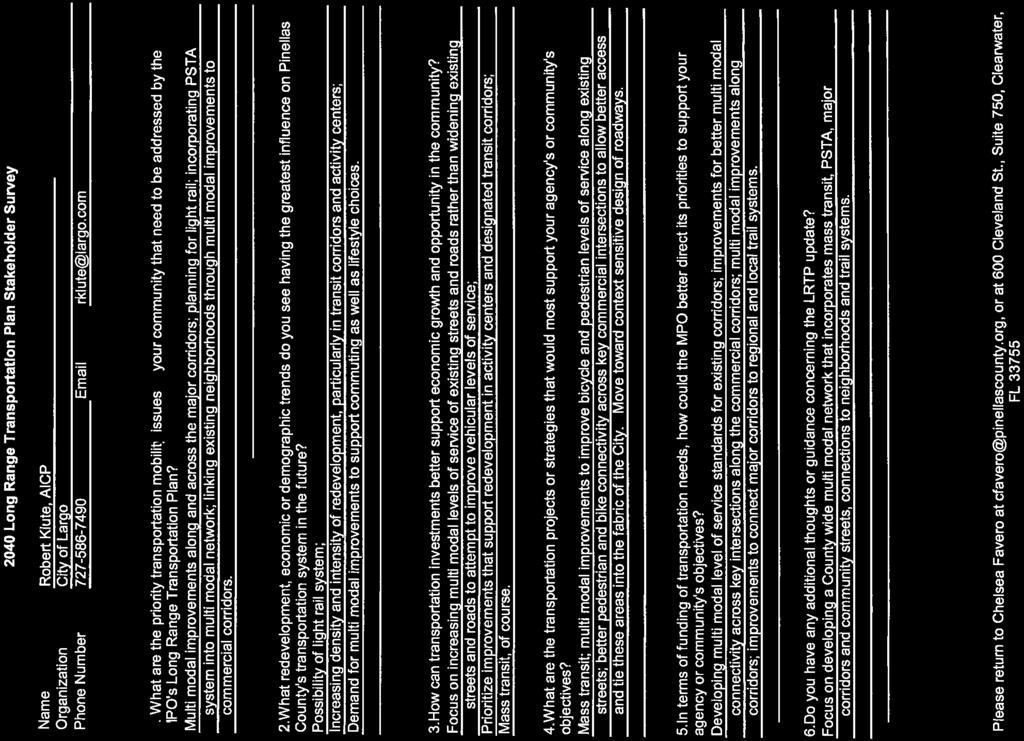
42
PINELLAS COUNTY MOBILITY PLAN SUMMARY REPORT
 PINELLAS COUNTY MOBILITY PLAN SUMMARY REPORT In September, 2013, the Pinellas County Mobility Plan Report was approved by the Metropolitan Planning Organization (MPO). This action endorsed a countywide
TBARTA 2015 Regional Transportation Master Plan 2040 Regional Long Range Transportation Plan AUGUST 2015
 TBARTA 2015 Regional Transportation Master Plan AUGUST 2015 Table of Contents 1.0 Introduction... 2 1.1 Updating the Master Plan... 2 1.2 About this Document... 2 2.0 Regional Long Range Transportation
BICYCLE/PEDESTRIAN ACCESS TO TRANSIT SAFETY ASSESSMENT FOR EXISTING AND PLANNED SECTIONS OF US 19
 BICYCLE/PEDESTRIAN ACCESS TO TRANSIT SAFETY ASSESSMENT FOR EISTING AND PLANNED SECTIONS OF US 19 September 2015 A JOINT EFFORT OF THE PINELLAS METROPOLITAN PLANNING ORGANIZATION AND THE FLORIDA DEPARTMENT
12 Evaluation of Alternatives
 12 Evaluation of Alternatives This chapter evaluates the effectiveness of the No-Build Alternative and the proposed METRO Blue Line Light Rail Transit (BLRT) Extension project based on the information
POLK COUNTY TPO Polk County 2060 Transportation Vision Plan Final Report. ADOPTED June 18, 2009
 POLK COUNTY TPO Polk County 2060 Transportation Vision Plan Final Report ADOPTED June 18, 2009 TABLE OF CONTENTS CHAPTER 1 Introduction and Prior Planning Effort...Page 1-1 CHAPTER 2 Population and Employment
MOBILITY 2045: A FOCUS ON TRANSPORTATION CHOICE:
 Mobility 2045: The Metropolitan Transportation Plan for North Central Texas is the defining vision for the multimodal transportation system in the Dallas- Fort Worth Metropolitan Planning Area. The plan,
SCS Scenario Planning
 E SCS Scenario Planning Introduction As part of the 2035 MTP/SCS process, AMBAG developed a series of land use and transportation alternative scenarios for evaluation and testing to demonstrate how the
Transportation and Utilities
 4 Section 4 Transportation and Utilities 4.0 Introduction Transportation and utility systems are essential to accommodate and support development proposed in the Future Land Use Map. The following pages
Contents i Contents Page 1 A New Transportation Plan Community Involvement Goals and Objectives... 11
 Contents i Contents 1 A New Transportation Plan... 1 Why develop a new plan?... 1 What area does the LRTP focus on?... 2 Why is this LRTP important?... 3 Meeting Requirements for Transportation Planning...
- FACT SHEET - THE GUIDING PRINCIPLES
 THE GUIDING PRINCIPLES The General Plan begins with seven ideas that together create a vision for the City s future. When the City approved the General Plan in 1994, these idea were dubbed the Seven Guiding
GUIDING PRINCIPLES MEMORANDUM
 M E T R O P O L I TAN TRA NS P O RTATI O N PLAN GUIDING PRINCIPLES MEMORANDUM El Paso Metropolitan Planning Organization INTRODUCTION The guiding principles for development of the El Paso MPO s Destino
ACTIVE TRANSPORTATION ADVISORY COMMITTEE. Memphis MPO March 30, 2015
 ACTIVE TRANSPORTATION ADVISORY COMMITTEE Memphis MPO March 30, 2015 Agenda Welcome & Introductions Announcements and Briefings Livability 2040: Regional Transportation Plan Congestion Management Process
Evaluation of Alternatives
 Chapter 9.0 Evaluation of Alternatives Chapter 9.0 provides a summary evaluation of the No Build Alternative and the Preferred Alternative. The evaluation contained within this chapter is an assessment
TRANSPORTATION RELATIONSHIP TO OTHER ELEMENTS OF THE PLAN AND COUNTY REGULATIONS VISION FOR TRANSPORTATION PLANNING ROAD NETWORK SECTION 7
 TRANSPORTATION Like many growing western counties, Douglas County focuses on one of the most integral elements in land-use planning: transportation. The primary purpose of a transportation network is to
6.0 CONGESTION HOT SPOT PROBLEM AND IMPROVEMENT TRAVEL DEMAND MODEL ANALYSIS
 6.0 CONGESTION HOT SPOT PROBLEM AND IMPROVEMENT TRAVEL DEMAND MODEL ANALYSIS 6.1 MODEL RUN SUMMARY NOTEBOOK The Model Run Summary Notebook (under separate cover) provides documentation of the multiple
EXECUTIVE SUMMARY REGIONAL TRANSPORTATION PLAN 2050
 EXECUTIVE SUMMARY REGIONAL TRANSPORTATION PLAN 2050 Introduction Goals Policies, and Performance Measures Growth Forecast and Planned Land Use Development Key Recommendations i Executive Summary April
3.0 REVIEW OF PREVIOUS STUDIES
 3.0 REVIEW OF PREVIOUS STUDIES This section of the highlights the significant features from previous plans and studies that could impact the development of the I-20 East Transit Initiative. Much of the
Chapter 5 Transportation Draft
 Chapter 5 Transportation Draft Discussion Similar to the other elements in the Comprehensive Plan, the transportation element impacts the quality of life, economic development and public safety of the
Livability 2050 Regional Transportation Plan Update. Transportation Policy Board (TPB) August 23, 2018
 August 23, 2018") Livability 2050 Regional Transportation Plan Update Transportation Policy Board (TPB) August 23, 2018 1 Oct. 2017 Plan Kick-Off Sept. 2019 Plan Adoption Timeline Livability 2050 Regional Transportation
Livability 2050 Regional Transportation Plan Update Transportation Policy Board (TPB) August 23, 2018 1 Oct. 2017 Plan Kick-Off Sept. 2019 Plan Adoption Timeline Livability 2050 Regional Transportation
SOUTHWEST LRT (METRO GREEN LINE EXTENSION)
") 8 Evaluation of Alternatives This chapter evaluates the effectiveness of the No Build Alternative and the Southwest Light Rail Transit (LRT) Project (the Project) based on the information contained in
8 Evaluation of Alternatives This chapter evaluates the effectiveness of the No Build Alternative and the Southwest Light Rail Transit (LRT) Project (the Project) based on the information contained in
6 CHARTING PERFORMANCE
 DRAFT 6 CHARTING PERFORMANCE OVERVIEW OF PERFORMANCE BASED PLANNING Background of Performance Based Planning Increasingly, over the past two decades, transportation agencies have been utilizing performance
2. Guiding Principles, Objectives, and Policies
 2. Guiding Principles, Objectives, and Policies INTRODUCTION The guiding principles for the 2040 MTP Update establish the vision and key focus areas for this planning effort. They combine the guidance
Summary of transportation-related goals and objectives from existing regional plans
 SMTC 2050 Long Range Transportation Plan Appendix A: Summary of transportation-related goals and objectives from existing regional plans SMTC 2050 Long Range Transportation Plan Summary of transportation-related
2030 Transportation Policy Plan SUMMARY PRESENTATION. Land Use Advisory Committee November 15, 2012
 2030 Transportation Policy Plan SUMMARY PRESENTATION Land Use Advisory Committee November 15, 2012 Today s Topics Transportation Policy Plan (TPP) Requirements and Background Current TPP Policies, Issues
1: INTRODUCTION AND PROCESS OVERVIEW
 GPATS Long-Range Transportation Plan 1: INTRODUCTION AND PROCESS OVERVIEW INTRODUCTION affects everyone in many ways and plays a critical role in shaping a region s physical and social infrastructure.
Chapter 14 Work Program
 Chapter 14 Work Program The Metropolitan Council will carry out or participate in many studies and plans over the next three years. This is not an exhaustive list of all work to be completed by the Metropolitan
VISION STATEMENT, MISSION STATEMENT, AND GOALS AND OBJECTIVES
 VISION STATEMENT, MISSION STATEMENT, AND GOALS AND OBJECTIVES Vision Statement: Our vision is to provide a high quality, safe, efficient, and cost-effective multi-modal transportation system that supports
Northern Virginia Region Draft Needs Summary
 Needs Map: Need A A DEMAND The ability of communities around transit stations (particularly the areas within 1-2 miles of the stations and other travel hubs) to attract skilled workers and grow businesses
2004 FEASIBILITY STUDY UPDATE
 Austin-San Antonio Intermunicipal Commuter Rail District 2004 FEASIBILITY STUDY UPDATE December 2004 EXECUTIVE SUMMARY INTRODUCTION Almost 3 million people in Central Texas, living and working between
MEMORANDUM #4. DATE: November 4, Warrenton TSP Project Management Team. Ray Delahanty, AICP, DKS Associates Kate Petak, EIT, DKS Associates
 MEMORANDUM #4 DATE: November 4, 2015 TO: FROM: SUBJECT: Warrenton TSP Project Management Team Ray Delahanty, AICP, DKS Associates Kate Petak, EIT, DKS Associates Warrenton Transportation System Plan Update
CRTPA Regional Mobility Plan Attachment 1 Agenda Item 4E Page 1 of 11
 CRTPA Regional Mobility Plan Attachment 1 Page 1 of 11 INTRODUCTION Everyone wants to have the ability to move around the city, county, region, country and world in the way that they see fit, when they
2017 TRANSPORTATION POLICY STATEMENT
 0 TRANSPORTATION POLICY STATEMENT 1 1 1 1 1 1 0 1 0 1 0 1 Critical investments are needed to maintain and improve Virginia s transportation network. The structural imbalance between critical needs and
Chapter 6: Regional Transportation
 Chapter 6: Regional Transportation Continued growth and development throughout the region magnifies the significance of connections to surrounding counties as economic and social interactions continue
APPENDIX A - PLANS AND POLICY REVIEW FEBRUARY 2017
 APPENDIX A - PLANS AND POLICY REVIEW FEBRUARY 2017 DENVERMOVES Transit Denver Moves: Transit APPENDIX A PLANS AND POLICY REVIEW 2035 Metro Vision Regional Transportation Plan (MVRTP) (2011) 2040 Fiscally
Congestion Management Process 2013 Update
 OVERVIEW OF THE DALLAS-FORT WORTH CONGESTION MANAGEMENT PROCESS Traffic Congestion In The Dallas-Fort Worth Region With the Dallas-Fort Worth (DFW) urban area as its center, the North Central Texas region
VIA Long Range Plan Glossary
 VIA Long Range Plan Glossary Accessibility. Accessibility is the ability to reach opportunities (economic, social, etc.) within a certain geographical area. Americans with Disabilities Act (ADA). Passed
SOUTHEAST FLORIDA REGIONAL COMPACT CLIMATE CHANGE. Sustainable Communities & Transportation Planning
 SOUTHEAST FLORIDA REGIONAL COMPACT CLIMATE CHANGE Draft Regional Climate Action Plan Sustainable Communities & Transportation Planning SP-1 Develop criteria in collaboration with municipal and county planning
Mobility Management STAFF SUMMARY REPORT
 Mobility Management STAFF SUMMARY REPORT COMPREHENSIVE PLAN AMENDMENTS Transportation Element Capital Improvement Element LAND DEVLOPMENT REGULATIONS Mobility Update Treasure Island PAGE INTENTIONALLY
City of Charlottesville MEMO
 City of Charlottesville MEMO TO: City Council FROM: Missy Creasy, Planning Manager DATE: August 7, 2013 SUBJECT: A World Class City www.charlottesville.org 2013 Comprehensive Plan Outline of updates made
The Role of Transportation Systems Management & Operations in Supporting Livability and Sustainability
 The Role of Transportation Systems Management & Operations in Supporting Livability and Sustainability Michael Grant, ICF International February 7, 2012 NTOC Webinar Highlights of FHWA/FTA Primer Background:
CHAPTER 3 THE BUILDING BLOCKS POLICIES AND SUPPORTIVE STRATEGIES REGIONAL TRANSPORTATION PLAN/SUSTAINABLE COMMUNITIES STRATEGY
 CHAPTER 3 THE BUILDING BLOCKS POLICIES AND SUPPORTIVE STRATEGIES REGIONAL TRANSPORTATION PLAN/SUSTAINABLE COMMUNITIES STRATEGY CHAPTER 3 THE BUILDING BLOCKS POLICIES AND SUPPORTIVE STRATEGIES INTRODUCTION
PennDOT Office of Planning
 Every Voice Counts PennDOT Office of Planning Environmental Justice Plan Executive Summary Developed for: Pennsylvania Department of Transportation Office of Planning Center for Program Development and
Chapter #9 TRAVEL DEMAND MODEL
 Chapter #9 TRAVEL DEMAND MODEL TABLE OF CONTENTS 9.0 Travel Demand Model...9-1 9.1 Introduction...9-1 9.2 Overview...9-1 9.2.1 Study Area...9-1 9.2.2 Travel Demand Modeling Process...9-3 9.3 The Memphis
CHAPTER 8 TRANSPORTATION ELEMENT
 CHAPTER 8 TRANSPORTATION ELEMENT Section 8.01 Purpose: The purpose of this Chapter (element) is to establish the desired and projected transportation system within Niceville and to plan for future motorized
Working with Transportation Concurrency Exception Areas
 Working with Transportation Concurrency Exception Areas September 2006 Presented by the Florida Department of Transportation Working with Transportation Concurrency Exception Areas Volume 1, September
1.1.1.b. Agencies share best practices as they integrate COMPASS facilitates
 Transportation Goals 1.1 Enhance the system to improve accessibility and connectivity to jobs, schools, and services; allow the efficient movement of people and goods; and ensure the reliability of travel
2040 Addendum Performance-Based Planning November 2018
 2040 Long Range Transportation Plan 2040 Addendum Performance-Based Planning November 2018 Adopted June 13, 2018 250 S. Orange Ave, Suite 200, Orlando, FL 32801 407-481-5672 www.metroplanorlando.org MetroPlan
Tri-County Regional Planning Commission 2045 Regional Metropolitan Transportation Plan Goals and Objectives Adopted March 22, 2017
 Tri-County Regional Planning Commission 2045 Regional Metropolitan Transportation Plan Goals and Objectives Adopted March 22, 2017 One of the initial steps in the development of the TCRPC 2045 Metropolitan
MTP VISIONS, GOALS, AND OBJECTIVES
 2 MTP VISIONS, GOALS, AND OBJECTIVES El Paso MPO 2045 Metropolitan Transportation Plan 2. GUIDING PRINCIPLES This chapter describes the process by which the vision and goals of the planning process were
Appendix O Congestion Management Program REGIONAL TRANSPORTATION PLAN/SUSTAINABLE COMMUNITIES STRATEGY
 Appendix O Congestion Management Program REGIONAL TRANSPORTATION PLAN/SUSTAINABLE COMMUNITIES STRATEGY 2014 REGIONAL CONGESTION MANAGEMENT PROGRAM 2014 RTP/SCS APPENDIX O SAN JOAQUIN COUNCIL OF GOVERNMENTS
What is the Transportation Policy Plan (TPP)?
?") Summary What is the Transportation Policy Plan (TPP)? The region s long range transportation plan Includes all modes of transportation: highways, transit, airports, freight, biking, pedestrians Meets the
Summary What is the Transportation Policy Plan (TPP)? The region s long range transportation plan Includes all modes of transportation: highways, transit, airports, freight, biking, pedestrians Meets the
2040 Long Range Transportation Plan
 2040 Long Range Transportation Plan Presented by Iowa Northland Regional Council of Governments October 22, 23, and 24, 2013 Liaison for federal transportation funding that goes to local cities and counties
NORTH I-75 MASTER PLAN Summary Report
 NORTH I-75 MASTER PLAN Summary Report Interstate 75 (SR 93) From the Florida s Turnpike Interchange to the I-10 Interchange Alachua, Bradford, Clay, Citrus, Columbia, Duval, Levy, Marion, and Sumter Counties,
Proposed Comprehensive Update to the State of Rhode Island s Congestion Management Process
 Proposed Comprehensive Update to the State of Rhode Island s Statewide Planning Program January 2018 Summary Outline of of Action Steps 1. Develop Objectives for Congestion Management What is the desired
AICP EXAM REVIEW. Transportation Planning. February 19, 2016
 AICP EXAM REVIEW Transportation Planning February 19, 2016 Agenda Defining transportation planning Transportation stakeholders Transportation plan development Transportation funding Project development
2035 LRTP Transportation Options Introduction
 2035 LRTP Transportation Options Introduction What is the 2035 LRTP? The 2035 Long-Range Transportation Plan (LRTP) is the guide for major transportation investments in the Durham-Chapel Hill-Carrboro
4: Transportation and Land Use
 Chapter Figure 4-1: Recent development has brought more housing and mixed use Downtown Minneapolis - looking north from E 15th Street at the Grant Street / 11th Street exit 4: Transportation and Land Use
LUNDY S LANE COMMUNITY IMPROVEMENT PLAN STUDY
 PUBLIC INFORMATION MEETING # October, 0 LUNDY S LANE COMMUNITY IMPROVEMENT PLAN STUDY AGENDA :00 to :0pm: Open House :0 to :pm: Presentation : to :00pm: Individual paced workshop with the Study Team PUBLIC
This document has been developed to provide context to the Board as part of the strategic planning process. Regional development and travel trends
 1 This document has been developed to provide context to the Board as part of the strategic planning process. Regional development and travel trends and forecasts are provided, including population, employment,
SUSTAINABLE COMMUNITIES STRATEGY
 SUSTAINABLE COMMUNITIES STRATEGY Introduction With each RTP update cycle, BCAG prepares a Sustainable Communities Strategy (SCS) as required under Senate Bill 375 (SB 375). The SCS demonstrates the integration
Alternatives Evaluation Methodology
 Alternatives Evaluation Methodology www.vision54 56.com B 1 Phase 2 Alternatives Evaluation Methodology PASCO COUNTY METROPOLITAN PLANNING ORGANIZATION 8731 Citizens Drive New Port Richey, FL 34654 Ph
CHAPTER 1. A New Transportation Plan
 Chapter 1. A New Transportation Plan 1 CHAPTER 1. A New Transportation Plan Why develop a new plan? The year 2005 marks 90 years since Anchorage emerged as a community serving as headquarters for railroad
Sound Transit Transit-Oriented Development (TOD) Policy
 Policy") SECTION 1: PURPOSE Sound Transit Transit-Oriented Development (TOD) Policy The Transit-Oriented Development (TOD) Policy establishes a framework in which Sound Transit will evaluate, facilitate and implement
SECTION 1: PURPOSE Sound Transit Transit-Oriented Development (TOD) Policy The Transit-Oriented Development (TOD) Policy establishes a framework in which Sound Transit will evaluate, facilitate and implement
Chapter 3 - Goals, Objectives, & Strategies
 Chapter 3 - This chapter presents goals, objectives, and strategies that have been developed as part of the Richmond Area MPO 2026 Long-Range Transportation Plan (LRTP) update. Strategies have been developed
THE REGION S PLAN POLICY FRAMEWORK. August 2015
 THE REGION S PLAN POLICY FRAMEWORK August 2015 2 What is The Policy Framework? Cover photo credit: Sinan Sinharoy for Atlanta BeltLine, Inc. Atlanta is one of the world s most dynamic metropolitan areas,
Chapter 5 - Transportation
 Chapter 5 - Transportation Discussion Similar to the other elements in the Comprehensive Plan, the transportation element impacts the quality of life, economic development and public safety of the residents
APPENDIX B - GLOSSARY FEBRUARY 2017
 APPENDIX B - GLOSSARY FEBRUARY 2017 DENVERMOVES Transit Denver Moves: Transit - ii - APPENDIX B TRANSIT AND MOBILITY GLOSSARY Amenities, stop or station: Objects or facilities (such as a shelter, bench,
TCATS October 12-Michigan Works 5:30-7pm. NATS October 19-Niles District Library 6-7:30pm
 Goal Development Workshop TCATS October 12- Works 5:30-7pm NATS October 19-Niles District Library 6-7:30pm SAFETEA-LU Goals 2035 TwinCATS Goals 2030 TwinCATS Goals 1. Support the economic vitality of the
The Level of Service Metric and. Alternatives for Multi-Modal Transportation. in Oakland
 The Level of Service Metric and Alternatives for Multi-Modal Transportation in Oakland By Jill Nevins For the City of Oakland, Public Works Agency Mills College Public Policy Program May 2012 Executive
Purpose of the Countywide Transportation Plan SAN FRANCISCO COUNTY TRANSPORTATION AUTHORITY
 > 12 Purpose of the Countywide Transportation Plan SAN FRANCISCO COUNTY TRANSPORTATION AUTHORITY 13 SAN FRANCISCO S MULTIMODAL transportation network is crucial to San Francisco s status as a major regional
CHAPTER 1: INTRODUCTION/ GOALS AND OBJECTIVES
 CHAPTER 1: INTRODUCTION/ GOALS AND OBJECTIVES 1.1: INTRODUCTION ABOUT THE FREDERICKSBURG AREA METROPOLITAN PLANNING ORGANIZATION (FAMPO) Established in 1992, the Fredericksburg Area Metropolitan Planning
Highest Priority Performance Measures for the TPP
 Highest Priority Performance Measures for the TPP The following list of measures are the highest priority performance measures as identified by modal working groups. These groups consist of staff from
CHAPTER 2. VISION, GOALS AND MTP FRAMEWORK
 CHAPTER 2. VISION, GOALS AND MTP FRAMEWORK MTP VISION In order to create a framework for the 2040 Metropolitan Transportation Plan (MTP), a vision statement was drafted by the Vision/Goals Committee and
WTP 2035 DRAFT STRATEGIES AND ACTIONS
 INTRODUCTION This Working Paper presents draft strategies and actions to be considered for inclusion in the draft Washington Transportation Plan 2035. It includes reference to the existing WTP 2030 strategies
Chapter 1: The MPO Board includes representatives of four local governments and four transportation authorities
 Safe, Accountable, Flexible, And Efficient Transportation Equity Act: A Legacy for Users (SAFETEA-LU). The Imagine 2040 Plan will follow the guidelines as outlined in the current Federal Transportation
Guiding Principles of the Plan:
 REGIONAL TRANSIT FEASIBILITY PLAN The Regional Transit Feasibility Plan continues to make progress, having completed the first step of the defined process to evaluate opportunities for premium transit
Performance Measures Workshop, May 18, 2017
 Measuring What Matters: Above and Beyond Requirements Performance Measures Workshop, May 18, 2017 Presentation Overview Background - origin and evolution of the Regional Outcomes Framework. Regional Outcomes
CHAPTER HIGHLIGHTS GOALS AND GUIDING POLICIES 60 SEEKING PUBLIC INPUT TO REFINE SCENARIOS FOR OUR FUTURE 61
 04 CHAPTER HIGHLIGHTS GOALS AND GUIDING POLICIES 60 SEEKING PUBLIC INPUT TO REFINE SCENARIOS FOR OUR FUTURE 61 SCENARIOS FOR THE FUTURE: IT S OUR CHOICE 63 CREATING A PLAN FOR OUR FUTURE The RTP/SCS is
Transportation Master Plan Introduction
 1. Introduction Building a Liveable Ottawa 2031 has set out a process to guide the completion of a fiveyear update of the City s Official Plan, Transportation Master Plan, Infrastructure Master Plan, Cycling
TRANSIT SYSTEM SUMMARY REPORT
 Genesee County Shaping our Transportation Future Together 2035 Long Range Transportation Plan TRANSIT SYSTEM SUMMARY REPORT Introduction The Genesee County Transit Technical Report is one of 19 technical
Chapter 4: Transportation and Land Use
 Chapter 4: Transportation and Land Use Transportation and land use together make possible the wide range of destination opportunities in the region. Transportation provides the connections, and, in turn,
Public Input from Regional Visioning Forums
 Public Input from Regional Visioning Forums Innovation and Economic Development Provide transportation systems to continue to position Florida as a global hub for trade, logistics, and exports-oriented
PERFORMANCE-BASED PLANNING AND PROGRAMMING
 February 2017 performance-based planning and programming Boston Region MPO PERFORMANCE-BASED PLANNING AND PROGRAMMING WHAT IS PERFORMANCE-BASED PLANNING AND PROGRAMMING? Performance-based planning and
Executive Summary and Staff Recommendation
 Executive Summary and Staff Recommendation January 2017 Project Background In 2010, NFTA completed an update to our 2001 Strategic Assessment. This assessment identified four corridors for potential rail
Transportation A Conversation on Regional Transportation. Tacoma City Manager April 15, Update to the Regional Transportation Plan
 Transportation 2040 Update to the Regional Transportation Plan A Conversation on Regional Transportation Tacoma City Manager April 15, 2009 1 Puget Sound Regional Council The Region: 4 counties 82 cities
2040 Long Range Transportation Plan
 2040 Long Range Transportation Plan Executive Summary Adopted April 15, 2013 The Current Situation The George Washington Region includes the City of Fredericksburg and the counties of Caroline, King George,
SUBURBAN EDGE COMMUNITY ROLE COUNCIL ROLE ALL COMMUNITIES SUBURBAN EDGE
 Orderly and Efficient Land Use Align land use, development patterns, and infrastructure to make the best use of public and private investment. Plan and stage development for forecasted growth through 2040
MONITORING IMPLEMENTATION AND PERFORMANCE
 12 MONITORING IMPLEMENTATION AND PERFORMANCE The FAST Act continues the legislation authorized under MAP-21, which created a data-driven, performance-based multimodal program to address the many challenges
ARC Freight Advisory Task Force Meeting. SOUTH FULTON COMMUNITY IMPROVEMENT DISTRICT Multi-Modal Study
 ARC Freight Advisory Task Force Meeting SOUTH FULTON COMMUNITY IMPROVEMENT DISTRICT Multi-Modal Study March 1, 2018 Outline Study Overview Scope of Work Key Investment Needs Draft Investment Recommendations
Sustainable Transportation Performance Measures
 Sustainable Transportation Performance Measures Christopher Forinash EPA Office of Sustainable Communities Conference on Performance Measures for Transportation and Livable Communities Austin, Texas 7
CONNECTING LAND USE AND TRANSPORTATION PLANNING THE LINKAGE MODEL FOR METROPOLITAN PLANNING ORGANIZATIONS
 NEW YORK STATE ASSOCIATION OF METROPOLITAN PLANNING ORGANIZATIONS CONNECTING LAND USE AND TRANSPORTATION PLANNING THE LINKAGE MODEL FOR METROPOLITAN PLANNING ORGANIZATIONS Prepared by Chris O'Neill, CDTC
TRANSPORTATION 101 Today and Tomorrow. Moving People and Goods
 TRANSPORTATION 101 Today and Tomorrow Moving People and Goods What is the Transportation Commission? An independent, seven-member body of citizens appointed by the Governor for six-year terms and representing
EXHIBIT 2 SCOPE OF SERVICES FOR THE GAINESVILLE URBANIZED AREA YEAR 2040 LONG RANGE TRANSPORTATION PLAN UPDATE. Prepared by:
 CA.5 EXHIBIT 2 SCOPE OF SERVICES FOR THE GAINESVILLE URBANIZED AREA YEAR 2040 LONG RANGE TRANSPORTATION PLAN UPDATE Prepared by: Metropolitan Transportation Planning Organization for the Gainesville Urbanized
Transportation, Mobility and Access
 Transportation, Mobility and Access In The City of North Vancouver A Discussion Paper Prepared to Inform the Direction of a New Official Community Plan 2021 & Beyond Dragana Mitic Assistant City Engineer
ALBION FLATS DEVELOPMENT EXISTING TRAFFIC CONDITIONS AND POTENTIAL IMPACTS
 EXISTING TRAFFIC CONDITIONS AND POTENTIAL IMPACTS FINAL REPORT SEPTEMBER 2010 TABLE OF CONTENTS 1.0 INTRODUCTION 1 2.0 EXISTING TRAFFIC CONDITIONS 2 3.0 FUTURE TRAFFIC CONDITIONS 3 4.0 POTENTIAL IMPACTS
NJTPA Region. Bergen Essex Hudson Hunterdon Jersey City Middlesex Monmouth Morris. Newark Ocean Passaic Somerset Sussex Union Warren
 NJTPA Region Bergen Essex Hudson Hunterdon Jersey City Middlesex Monmouth Morris Newark Ocean Passaic Somerset Sussex Union Warren North Jersey Transportation Planning Authority The Metropolitan Planning
EIGHT PLANNING FACTORS
 EIGHT PLANNING FACTORS Under the provisions of SAFETEA-LU, all Metropolitan Planning Organizations (MPOs) are required to consider eight (8) broad planning factors in the development of multi-modal transportation
Section 11: Transportation Strategies Toolbox
 Section 11: Transportation Strategies Toolbox A transportation strategies toolbox was developed to provide a systematic approach to identify potential strategies that address corridor transportation needs.
MEETING: DATE: TYPE OF ACTION: STAFF CONTACT: PHONE: Recommend to Board. Final Action
 RESOLUTION NO. R2012-24 Transit-Oriented Development Policy MEETING: DATE: TYPE OF ACTION: STAFF CONTACT: PHONE: Executive Committee Board PROPOSED ACTION 12/06/2012 12/20/2012 Recommend to Board Final
CHAPTER 4 HIGHLIGHTS GOALS AND GUIDING POLICIES 64 SEEKING PUBLIC INPUT TO REFINE SCENARIOS FOR OUR FUTURE 66
 04 CHAPTER 4 HIGHLIGHTS GOALS AND GUIDING POLICIES 64 SEEKING PUBLIC INPUT TO REFINE SCENARIOS FOR OUR FUTURE 66 SCENARIOS FOR THE FUTURE: IT S OUR CHOICE 68 CREATING A PLAN FOR OUR FUTURE The RTP/SCS