WHITEHEAD ENVIRONMENTAL CONSULTANTS LTD.
|
|
|
- Roy Carpenter
- 6 years ago
- Views:
Transcription
1 WHITEHEAD ENVIRONMENTAL CONSULTANTS LTD. P.O. Box 41 (535C Artisan Lane), Bowen Island, B.C., Canada V0N 1G0 Tel.: (604) alanjw@telus.net - Fax: (604) Armac Construction Ltd. P.O. Box 218 Bowen Island, B.C. V0N 1G0 29 July 2009 Project File: Attention: Roger McGillivray Dear Mr. McGillivray; RE: BIOPHYSICAL ASSESSMENT OF THE BELTERRA PROPERTY, BOWEN ISLAND. completed an environmental assessment of the above property in May and June This document provides our biophysical assessment report for development planning purposes, as requested by you and required by the Bowen Island Municipality s Planning Department. The report is based on our review of prior reports and a series of field investigations by the undersigned in May and June The purpose of this report is to: supplement the prior reports and provide information on the presence/absence of sensitive plant or animal species, habitats or ecosystems; determine the streamside protection setback required in accordance with the provincial Riparian Areas Regulation (RAR); evaluate the existing pedestrian trails within the property; and provide recommendations for the management of site drainage. 1. PROJECT UNDERSTANDING The subject property is described legally as Lot B, District Lot 489, Group 1, New Westminster District, Plan 22869, and covers approximately 10.0 acres (4.047 hectares) (Figures 1 and 2). It is accessed from Carter Road immediately west of Island Pacific School (IPS) and Cates Hill Chapel. The neighbouring properties include an undeveloped portion of the Camp Bow-Isle lands to the west; Raven Hill Farm to the northwest; undeveloped municipal lands to the north; IPS, Cates Hill Chapel and covenanted lands of the Terminal Creek ravine to the east; and Grafton Road and developed estate-size residential lots on Cates Hill to the south. Our understanding is that you intend to develop a cohousing project, known as Belterra, on the property. The proposed layout of the development is yet to be determined, as it will be created jointly by the cohousing partners. However, you have already delineated a proposed natural park area along the Terminal Creek ravine and intend to retain the connections to the existing trail network (Figure 2). As part of the development planning, you have commissioned a number of prior environmental studies and opinions and solicited comment from regulatory agencies,
2 Biophysical Assessment of the Belterra Property, Bowen Island p. 2 particularly with regard to protection of Terminal Creek and its riparian corridor and other potentially sensitive environments on the property.

3 Biophysical Assessment of the Belterra Property, Bowen Island p. 3
.")
4 Biophysical Assessment of the Belterra Property, Bowen Island p EXISTING CONDITIONS 2.1 Built Infrastructure The main driveway access is already in place and drivable to the top of the property; however additional surfacing is still needed (Figure 2). There is no permanent residence on the property at present; however, there is a small cabin, occupied by Bowen Island artist Bob Bates, and a storage trailer on the lower part of the property above IPS. The only other infrastructure includes the Cove Bay Water System (CBWS) pipeline and maintenance trail along the north side of Terminal Creek within a Statutory Right-of-Way (Plan LMP35692 and Plan 17871). There is also a cement dam above a bedrock waterfall on Terminal Creek adjacent to the extreme southwest corner of the property. Existing trails, although not built structures, are considered part of the existing infrastructure. The property contains connections to four trails that are part of the informal, island-wide trail network which crosses private and public lands (Figure 2). Two trails cross the property from east to west: one following the CBWS pipeline and the other following the existing driveway for much of its length. The other trails are oriented north-south, the third linking to a private property to the north, and the fourth connecting the IPS parking lot to the pipeline trail to the south. 2.2 Physiography and Soils The subject lands are located on the southeast-facing flank of a hill on the north side of Terminal Creek. Elevations above sea level range from approximately 60 m in the ravine bottom on the east side, to 125 m on the hilltop near the northwest corner (Fig. 2). Topographic details are shown in Figure 2. The topography is variable and can be characterized as moderately to steeply sloping with numerous steeper areas and occasional flatter benches; the steepest lands occur in the northwest corner (where cliffs are present) and along the Terminal Creek ravine, in the southwest. The distribution of soil types on the project lands according to the BC Soil Survey map is shown in Figure 3. Soil description summaries are provided in Table 1 on the next page. Soils consist of gravelly sandy loam, often stony, over glacial till or bedrock, with an abundance of bedrock outcrops of varying sizes. The topographic classes range from gently to strongly sloping, with gradients ranging from 5% to greater than 60%. PROJECT MY BO df MY BO - CE E - ef The BC Soils Atlas contains comments regarding land use opportunities and limitations, which are based on a very broad mapping scale. These comments, summarized in Table 1 are, therefore, very general in nature and subject to site-specific confirmation. Figure 3. Provincial soils mapping for the project area, Bowen Is. N
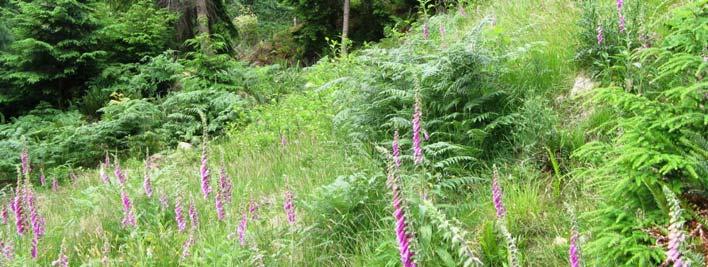
5 Biophysical Assessment of the Belterra Property, Bowen Island p. 5 Table 1. Description of the major soil types reported to occur in the Belterra Property. (after Luttmerding 1980, 1981) Soil Name a Material Drainage and Land Use Comments b (map symbol) water retention Bose Bose Low subsoil permeability and often strongly sloping (BO) topography limit septic tank effluent disposal. Cannell (CE) Rock Outcrop (RO) Murrayvill e (MY) 130 to 160 cm of gravelly lag or glaciofluvial deposits over moderately coarse-textured glacial till and some moderately fine-textured glaciomarine deposits. 10 to 100 cm of moderately coarse-textured glacial till or colluvium over bedrock Areas of bedrock exposed or with less than 10 cm of organic or mineral soils on the surface cm of moderately coarse to medium-textured littoral deposits over finetextured marine deposits. Well to moderately-well drained; low water-holding capacity; rapidly pervious in the upper layers, slowly pervious in the compacted underlay; lateral seepage along top of compacted subsoil is common after prolonged, heavy rain. Well to rapidly drained; low to moderate water holding capacity; rapidly pervious; lateral seepage along the surface of underlying bedrock. Rapidly drained; no moisture holding capacity; impervious; fast surface runoff. Mostly imperfectly drained, with perched water table during winter; may include moderately well drained areas; moderate water holding capacity and slow surface runoff Low subsoil permeability and often strongly sloping topography limit septic tank effluent disposal. Difficult to build roads through (blasting required). Development limitations possible due to variable bearing strengths and high shrink-well potential; septic tank effluent disposal is limited due to low subsoil permeability. a Soil types are presented in approximate order of abundance. b The land use comments included in the BC Soils Atlas are very general in nature. It should be understood that site-level capability for land use planning will need to be based on detailed evaluation of local characteristics. 2.3 Vegetation The property has been selectively logged on a number of occasions over the decades, beginning in the late 1800s or early 1900s, and most recently in the mid to late 1980s or early 1990s. Existing vegetation is represented by three native plant communities and three variations brought about by past human activity (Figure 2). The three native vegetation communities are mature second-growth coniferous forest (closed forest) which covers the largest area, terrestrial herbaceous (also known for present purposes as mossy bluff), and wetlands. The man-made areas include woodland, meadow and recently cleared areas. Each is described in greater detail below. Representative views of the vegetation are provided in the attached photos. Closed coniferous forest. Tree species in these areas include Douglas-fir, western redcedar and western hemlock (Photos 1 and 2). Deciduous tree species, which occur in amounts of less than 25%, include red alder and bigleaf maple, and are typically present along the edges of the woodlands, meadow and clearing or in the ravine bottom (Photos 3 and 4). The tallest conifers, mostly western redcedar and Douglas-fir, reach heights in excess of 40 m and diameters of ~1 m, mostly within the Terminal Creek ravine, where soils tend to be deepest. The understory in most of the coniferous forest consists of sword fern, salal and a variety of mosses, with red and evergreen huckleberry scattered throughout. The density of ground cover varies greatly and can be almost non-existent in areas that are densely shaded by the forest
6 Biophysical Assessment of the Belterra Property, Bowen Island p. 6 canopy. In the more open forest areas, salal or Oregon Grape can form very dense cover, and the shrub ocean spray is common beside the rock bluffs. Other woody shrubs include holly and red elderberry on more open areas, and salmonberry, stink currant, ninebark and devil s club beside Terminal Creek. Mossy bluff. The bedrock outcrops are typically covered by several species of mosses, lichens and grasses, as well as a variety of other herbaceous species, including stonewort, saxifrage, foxglove and small amounts of parsley fern and spleenwort (Photos 5, 6, 7 and 8). Salal and sword fern are also present along the edges where soils are slightly deeper. Parsley fern is relatively uncommon on Bowen Island as it is limited to very dry bluff habitats, usually near the shoreline. Wetland. The wetlands occur only in the Terminal Creek floodplain, are typically less than 10 m 2 and situated mostly in small depressional areas that are separate from the main stream channel (Photo 9). One wetland area was noted beside a pool of the main channel at the upstream end of the study area (Photo 10). Vegetation in the off-channel wetlands included mainly skunk cabbage and water parsley surrounded by salmonberry; while the streamside wetland was dominated by small fruited bulrush, angelica, horsetail and other water-loving species. Woodland. This term is used in this report to describe the areas that were selectively logged within the past 25 years and in which the individual trees tend to be more widely spaced and there is a greater proportion of deciduous trees. At least one large pile of woody debris, remaining from the last logging, was also observed. The predominant conifers are western hemlock and western redcedar (with Douglas fir limited to the drier sites), while the red alder and bigleaf maple are the deciduous trees. The woodland understorey is typically much more dense than in the closed forest due to the lack of excessive shade. Common understorey species include salal, Oregon grape, bracken fern, and grasses (Photos 11, 12, 13). Meadow. This area is characterized by an expanse of grasses and almost complete absence of tree cover, and occasional piles of stones or boulders. The trees would appear to have been removed at least 20 years ago and the soil mechanically leveled or graded after logging, which has led to the establishment of the complete grass cover. Other common species include bracken fern, thistle, dandelion, hawks bill, asters, pearly everlasting and soft rush, the latter being most common in areas where the soil is often saturated; seedlings of red alder and Douglas-fir (the latter heavily browsed by deer) were common on the north edge. (Photos 14, 15, 16). Clearing. This term is used in this report to describe two sites which, although cleared, have not become a meadow and still contain areas of exposed soil. One is located immediately below the driveway on the south side (Photo 17) and the other in the lower east side (Photo 18) (Figure 2). The predominant vegetation in the clearings includes bracken, thistle, grasses, salal, trailing blackberry, swordfern, and seedlings of hemlock and red alder. 2.4 Fish
7 Biophysical Assessment of the Belterra Property, Bowen Island p. 7 Terminal Creek, which is Bowen Island s most important fish stream, crosses the southern portion of the property from west to east. Fish species present within the property include resident coastal cutthroat trout, some of which can reach up to 30 cm in length. Chum and Coho salmon, as well as sea-run cutthroat trout also occur in this creek; however, their upstream limit is at the foot of the impassable falls below Carter Pond (Fig. 2). This stream originates in Grafton Lake approximately 1.3 km upstream and is used as a reservoir for the CBWS; the terms of the Water Licence require a minimum flow of 8.5 litres per second (0.3 cfs) to be released at all times into Terminal Creek at the lake outlet to sustain aquatic habitat. 2.5 Wildlife Wildlife in the general project area includes deer, small mammals such as mice, voles, shrews, Douglas squirrel in the more forested areas, and a diversity of resident and migratory songbirds, woodpeckers and raptors. Deer sign, including droppings, tracks and browsed vegetation were very common throughout the property, most notable on the mossy bluffs above the driveway and along the fringes of the meadow. Garter snakes and, possibly, northwestern alligator lizard are likely present in the more open areas such as the meadow and mossy bluffs; however none were observed during our study or noted in the previous reports. Amphibians in the area may include frogs, newts and salamanders; a Red-legged frog, which is a Blue-listed species, was observed in the Terminal Creek ravine. It is likely that a number of the live trees and standing dead trees in the ravine and other closed forest areas provide nesting and feeding habitat for a number of bird species including owls, woodpeckers, squirrels and others. Great Blue Heron, which are Blue-listed, have been observed along the stream. Blue Grouse, a species that is becoming less common on Bowen Island, used to be heard calling in the Cates Hill area to the south. The lack of recent records in the area suggests that this species is sensitive to development. No Blue Grouse were heard during the present assessment. Among the invertebrates, the most conspicuous species include slugs and snails in the moist forest areas, spiders and ticks, and butterflies, moths, beetles, small flies and other insects throughout. 2.6 Wells, Water Licences and Pipelines There are no wells on the property, to our knowledge. There are numerous water licences on Terminal Creek. The closest ones that are relevant to any development proposal for the Belterra lands are located at Carter Pond and at the foot of the falls downstream. Both licences are held by the Department of Fisheries and Oceans (DFO) for the purpose of water supply to the fish hatchery located farther downstream in Crippen Regional Park. The CBWS main water supply pipeline, which is buried along most of its length, follows the north side of Terminal Creek across the property and is paralleled by a maintenance trail that is also used recreationally (Figure 2).
8 Biophysical Assessment of the Belterra Property, Bowen Island p Site Drainage The lower half of the property below the driveway drains directly to the Terminal Creek ravine within the Belterra lands. Runoff occurs as dispersed or sheet flow over the surface and soon becomes shallow groundwater in uppermost layer of the forest soils; as a result, there are no defined water courses in this area. Some of the shallow groundwater emerges as surface water seeps at the toe of the ravine beside the pipeline corridor, and again soaks into the ground on its route to the aquifer below Terminal Creek. An area of unstable slope was observed on the steep ravine bank in the southwest portion of the property. At slump this site appears to have occurred as a result of saturation of the surface soils by shallow groundwater (Fig. 2; Photo 19) Drainage from the upper half of the property is intercepted by a ditch (Photo 20) along the ascending leg of the driveway and directed to two point discharges, one to Terminal Creek ravine above Carter Pond, and the other below Carter Road (Fig. 2). The upper drainage is conveyed under the driveway opposite the IPS parking area (Photo 21) and then follows a shallow ditch along the west side of the parking lot (Photo 22) and ultimately discharges to the ravine (Photo 23); the remains of two abandoned silt fences were observed at the discharge point (Photo 24). The lower drainage follows a shallow ditch beside the driveway (Photo 25), is culverted under Carter Road (Photos 26 and 27) and discharged to the top of the slope above the Municipal Works Yard. An overgrown swale at the foot of this slope (Photo 28) conveys seasonal runoff eastward toward Terminal Creek below the lower falls. Judging by the indistinct channel that has formed on the ravine banks below both discharges, it is evident that the volumes of runoff are typically very low. However, sediment has accumulated in the flatter portions of the ditches (reducing their capacity), and rills have been scoured into the surface soils on the steep banks, exposing vegetation roots (Photos 29 and 30). The above observations indicate that (a) there is a risk of flooding the roadbed during heavy rainfall due to sediment build-up in the ditches and/or blockage of the culvert, and (b) significant erosion can occur during periods of peak runoff such as very heavy rainstorms and rain-on-snow events. Over time, the loss of vegetation cover coupled with continued seasonal peak flows can lead to the formation of unstable gullies and, potentially, sedimentation of aquatic habitat within Terminal Creek. 2.8 Sensitive Ecosystems Sensitive ecosystems on Bowen Island have been mapped under the auspices of the federalprovincial Sensitive Ecosystem Inventory (SEI) (McPhee et al. 2000) and the Island Trust Ecosystem Mapping (ITEM) project (Islands Trust 2000). The accuracy of these inventories at the level of individual properties is limited because the mapping, under both systems, was based primarily on aerial photo interpretation followed by only partial ground-truthing. A review of these databases shows that the Belterra property contains the riparian corridor of Terminal Creek (SEI) and second growth forest (ITEM). Of these only the riparian corridor is considered truly sensitive.
9 Biophysical Assessment of the Belterra Property, Bowen Island p. 9 Based on the site-specific information collected during the present and previous studies in and around the subject lands, three species at risk were identified: red-legged frog, Great Blue Heron and Band-tailed Pigeon, all of which are Blue-listed provincially by the Conservation Data Centre (CDC) (Ministry of Environment 2007). The frog resides in the Terminal Creek ravine, feeding and likely also breeding there or in the upstream or downstream vicinity. The heron is an occasional visitor to the pools in the creek, where it feeds on fish. The pigeon may feed seasonally in the upper parts of the property (on holly, Saskatoon, trailing blackberry and other berries); however, no nests were observed; its use of the lands is, therefore, considered transient. Two sensitive ecosystem types (or environmentally sensitive areas ESAs) have been also identified: the riparian corridor of Terminal Creek; and the mossy bluffs on the west side of the property. Recommendations regarding protection of these ESAs and species at risk are provided in Section 5. The following factors contribute to the sensitivity of Terminal Creek and its riparian corridor: (a) the stream is high quality habitat for important fish populations; (b) the riparian vegetation provides nutrients to the stream ecosystem, (c) the forest root system plays an important role in stabilizing the steep ravine banks, and (d) the undisturbed valley-bottom area serves as a natural corridor for wildlife movement. The mossy bluff areas are considered sensitive due to the presence of plant and animal species that are specially adapted to the seasonally very dry and hot conditions and which, therefore, have a relatively limited distribution on Bowen Island and in the Georgia Basin region. Three mossy bluff areas were identified (Figure 2). Of these, mossy bluff #1 is the least disturbed and contains unique plant species, and is, therefore, considered more ecologically sensitive than the other two. Areas #2 and #3 appear to have developed into their current condition as a result of the tree cover removal, which allowed greater sunshine penetration to the ground and, in turn, caused increased dryness and heat; these areas were not found to contain unique plant species and are, therefore, considered relatively less sensitive. Our original work plan included an effort to ascertain whether or not the subject lands contained plant communities that are listed as being at risk by the CDC. Once in the field, in view of the partially disturbed nature of most of the property (with the exception of the Terminal Creek ravine), we determined that it was not possible to accurately identify any such areas and concluded, therefore, that such an approach was not justified in this case. 3. RIPARIAN AREA ASSESSMENT The riparian setback was conducted following Schedule A of the provincial Riparian Areas Regulation (RAR). The RAR method allows for two alternatives: a simple assessment, which is based on fish presence or absence and existing or potential streamside vegetation conditions, and a detailed assessment, which takes into account detailed site-specific observations on a number of ecological factors. The simple assessment leads to three possible outcomes for the width of the streamside protection area: 30 m, 15 m or 5 m. The detailed assessment method can lead to a variety of values for the width of the streamside protection area, and was used in this case.
10 Biophysical Assessment of the Belterra Property, Bowen Island p. 10 The detailed RAR assessment method entails the identification of stream reach boundaries 1, followed by measurement of channel bank-full widths at 10 m intervals at 11 points around the centre of the reach, measurement of the channel s average gradient, determination of the channel type (based on the relationship between width and gradient), potential vegetation type, and a zone of ecological sensitivity based on: bank stability and presence of large organic debris (LOD), shade and availability of fish food insects. The combination of the above information leads to the determination of the width of a Streamside Protection and Enhancement Area (SPEA), which is the term used in the RAR for the riparian setback. The results are summarized as follows. During the initial reconnaissance of Terminal Creek, it was determined that the project area encompassed one stream reach only, which was approximately 380 m long (Fig. 2). The width and gradient measurements yielded an average channel width of 6.48 m and an average gradient of 4% which, according to the graphic relationship stipulated in the RAR, is a cascade-pool channel type. Based on trees being identified as the potential riparian vegetation type, the widths of the zones of sensitivity for LOD and stability, shade and insects were determined to be 13 m, 15 m and 19.5 m, respectively. These results yield a SPEA width of 19.5 m, measured horizontally from the high water level. The SPEA boundary was then manually mapped onto the survey plan using the stream high water level identified by the professional land surveyor. The location of the SPEA in relation to the proposed park boundary is shown in Figure 4. It is clearly evident from these results that the proposed park boundary along the Terminal Creek ravine provides a significantly greater width of protection than the SPEA. continued on p A reach is defined as a length of a watercourse having similar channel shape, channel dimension and slope. Reach breaks are typically associated with abrupt changes in gradient, such as falls, cascades, pools, etc., or marked changes in channel shape.
 at the Belterra Project lands, Bowen Island. (Base map photographed from survey plan by Richard J.")
11 Biophysical Assessment of the Belterra Property, Bowen Island p. 11 BELTERRA PROJECT LANDS Terminal Creek SPEA width = 19.5 m Boundary of SPEA Boundary of Proposed Park Figure 4. Boundaries of the Proposed Park and of the Streamside Protection and Enhancement Area (SPEA) at the Belterra Project lands, Bowen Island. (Base map photographed from survey plan by Richard J. Martin, BCLS, 2008)
12 Biophysical Assessment of the Belterra Property, Bowen Island p SUMMARY OF KEY ENVIRONMENTAL ISSUES 4.1 Sensitive Species and Ecosystems The main sensitive species on the project area is the red-legged frog, which is present in the Terminal Creek ravine. This species is Blue-listed by the CDC, which means that it is considered vulnerable due to habitat loss. The prime habitat for this species lies entirely within the proposed nature park and is, therefore, not considered at risk due to the Belterra project. Two sensitive ecosystems or ESAs were found on the lands: the riparian corridor of Terminal Creek and the mossy bluff areas on the upper west side of the property, particularly near the northwest corner. The Terminal Creek riparian area is considered the key ESA on the property. This ESA lies entirely within the proposed park and is, therefore, considered adequately protected. The continued use of the existing trail beside the pipeline does not raise environmental concerns if the intensity of trail use continues to be the same as at present and no trail improvement is contemplated. The mossy bluff areas are considered sensitive due to the presence of plant and animal species that have a relatively limited distribution. Based on our understanding of the preliminary development concept, the mossy bluff #1 in the northwest corner of the Belterra lands north of the driveway will remain undisturbed, while most of the adjacent mossy bluff (#2) down slope on the east side of the driveway would be developed, and all or most of the lower mossy bluff (#3) would remain undisturbed. The proposed larger-than-required protection of the Terminal Creek ravine which, as indicated previously, is the key ESA on the property is considered by the undersigned to compensate for the likely losses in area #2 and potential minor losses in area #3, as these are judged to be less sensitive than area # Riparian Area Protection The results of this assessment confirm that the width of the proposed park area in relation to Terminal Creek is significantly greater than the width of the streamside protection and enhancement area required under the provincial Riparian Areas Regulation and the municipal Land Use Bylaw. As a result, the extent of the riparian and ravine habitat to be protected under the present conceptual park dedication far exceeds the requirements under the municipal and provincial regulations. Consequently, Terminal Creek and its riparian ecosystem are considered to be more than adequately protected by the proposed park. 4.3 Trails The Belterra lands contain pedestrian trails that connect to neighbouring properties and are used for private and/or public purposes. The continued use of these trails, as contemplated in the project concept, does not raise any environmental concerns. Minor improvements along the Terminal Creek pipeline trail can be made without increasing the risk of adverse effects on the stream and its riparian ecosystem. 4.4 Stormwater Management
13 Biophysical Assessment of the Belterra Property, Bowen Island p. 13 The portion of the Belterra lands where future development is proposed drains to two ultimate discharge points off the property above Terminal Creek, one immediately southeast of the project and the other farther east below Carter Road. Although the amount of flow carried in the associated ditches appears to be low at present, the ravine banks below both discharges points do show early signs of erosion. Once the property is further developed especially with an increase in impervious surfaces such as pavement and roofs the frequency and intensity of stormwater discharges can be expected to increase. The rate of erosion on the receiving banks will, therefore, also likely increase, potentially destabilizing the steep slopes and, ultimately, possibly leading to harmful alteration of fish habitat in Terminal Creek. The erosion and its potential impacts can be readily prevented or minimized (mitigated) by incorporating best practices into the design of the project s stormwater management system. 5. RECOMMENDATIONS The potential impacts described above can be mitigated through careful planning and design of the development(s), and by employing standardized best management practices (BMPs) during construction and subsequent operation. You have indicated your intention to retain the rural, forested aesthetics and other natural features of the land as much as possible. The following recommendations are offered to help you avoid or minimize environmental impacts and risks: 1. Design the project layout to use the existing driveway and former road beds as much as possible, rather than constructing new routes through undisturbed areas. 2. Schedule any clearing within the woodland areas, or blasting, to take place between August 16 and February 1 to avoid the bird nesting season. Also, a. the trees to be removed should be marked beforehand and then inspected by a qualified environmental professional before felling, to confirm that they do not contain any nests of owls, hawks, eagles or herons, or active nests of any other bird species; b. trees should be felled in a manner that avoids damage to adjacent trees and habitat; and c. where excavation is necessary, every effort should be made to avoid tearing the larger roots (>5 cm diameter) of adjacent trees to be retained; exposed root ends should be cut with a saw to aid in healing. 3. Design the storm water drainage system in a manner that tends to: a. provide sufficient capacity for the anticipated peak flows under extreme rainstorm events; b. detain runoff in areas of permeable soils to facilitate groundwater recharge; c. disperse runoff to the down-slope side of the new buildings rather than intercepting and channeling these flows to the existing ditch; d. provide sediment traps at the inlets of the culverts under the driveway and Carter
14 Biophysical Assessment of the Belterra Property, Bowen Island p. 14 Road; e. provide rock armour below the culvert outlets for energy dissipation, and other means of preventing erosion on the steep banks below these discharges; and f. incorporate yearly inspection and maintenance of all ditches, sediment traps and culverts into the project operations. Additional information can be obtained from the Ministry of Environment s Stormwater Planning Guidebook (see References). 4. Plan any development such that excavation or heavy truck traffic can be avoided during periods of heavy rainfall. 5. Construct additional sediment traps where necessary to collect any silt-laden runoff during the rainy season, and design these to facilitate future maintenance if they are to be retained after construction. Ensure that the sediment traps are maintained (i.e., accumulated sediment removed) frequently during the road and driveway construction period and at least annually thereafter. 6. Revegetate all areas of exposed soil as soon as possible after construction, and irrigate as necessary to promote early germination and root development. Preferably use native species for revegetation in areas that are not to become maintained gardens (see Appendix 1). 7. We also encourage you to consider creating rainwater harvesting systems including a large cistern for use in garden irrigation and fire suppression into each of the new buildings. The summertime use of rainwater harvested from rooftops during the rainy season can significantly reduce the demand on the local groundwater and surface water resources, thus contributing to the stewardship of the island s limited potable water supply. 8. Similarly, we encourage the use of road surfacing methods that retain the permeability of the travelled surface, especially in driveways and parking areas.
15 Biophysical Assessment of the Belterra Property, Bowen Island p. 15 We trust that this report meets your needs at this time. Should you have any questions or require any additional information, please contact the undersigned at your convenience at or by at Yours truly, WHITEHEAD ENVIRONMENTAL CONSULTANTS LTD. Alan J. Whitehead, M.Sc., R.P.Bio. Principal Attachments: References Photographs Appendix 1 Revegetation Guidelines c.c. Planning Department, Bowen Island Municipality
16 Biophysical Assessment of the Belterra Property, Bowen Island p. 16 REFERENCES Block, J (ed.) Bowen Island: a resource analysis for land use planning. The Islands Trust and Ministry of Municipal Affairs and Housing. Islands Trust. Islands Trust Ecosystem Mapping (ITEM) Luttmerding, H.A Soils of the Langley - Vancouver Map Area. Volume 2. Soils Map and Legend, Southern Sunshine Coast and Southern Coast Mountains (Scale 1:50 000). Resource Analysis Branch (RAB) Bulletin 18. B.C. Ministry of Environment Soils of the Langley - Vancouver Map Area. Volume 3. Descriptions of the Soils. Resource Analysis Branch (RAB) Bulletin 18. B.C. Ministry of Environment. McPhee, M., P. Ward, J. Kirby, L. Wolfe, N. Page, K. Dunster, N.K. Dawe and I. Nykwist Sensitive Ecosystems Inventory: Eastern Vancouver Island and Gulf Islands Volume 2: Conservation Manual. Technical Report Series No. 345, Canadian Wildlife Service, Environment Canada, Pacific and Yukon Region, British Columbia. Ministry of Environment. May Stormwater Planning: A Guidebook for British Columbia. (accessed 16 May 2008) Ministry of Environment BC Conservation Data Centre/ Data Access. (accessed June 24 th 2009)


17 Biophysical Assessment of the Belterra Property, Bowen Island p. 17 Photo 1. Mature second-growth coniferous forest in the Terminal Creek ravine near the east end of the Belterra property. Dog is walking on water pipeline maintenance trail. 19-Jun-09. Photo 2. Mature second-growth coniferous forest on the south side of the Terminal Creek ravine near the west end of the Belterra property. 19-Jun-09.


18 Biophysical Assessment of the Belterra Property, Bowen Island p. 18 Photo 3. Red alder and bigleaf maple within mature second growth coniferous forest on north side of Terminal Reek ravine. 19-Jun-09. Photo 4. Young red alder along bottom of the Terminal Creek ravine within the Belterra Project lands. 19-Jun-09.


19 Biophysical Assessment of the Belterra Property, Bowen Island p. 19 Photo 5. Mossy bluff (terrestrial herbaceous) vegetation community at northwest corner of the Belterra property, viewed to west from below end of driveway. 19-Jun-09 Photo 8. Mossy bluff (terrestrial herbaceous) vegetation community at mid-elevation west side of the Belterra property, viewed to west. 19-Jun-09


20 Biophysical Assessment of the Belterra Property, Bowen Island p. 20 Photo 7. Parsley fern growing on mossy bluff at northwest corner of Belterra property. 19-Jun-09. Photo 8. Spleenwort growing on mossy bluff at northwest corner of Belterra property. 19-Jun-09.


21 Biophysical Assessment of the Belterra Property, Bowen Island p. 21 Photo 9. Floodplain wetland beside Terminal Creek within Belterra property. 19-Jun-09. Photo 10. Riparian wetland beside Terminal Creek near west boundary of Belterra property. 19-Jun-09.


22 Biophysical Assessment of the Belterra Property, Bowen Island p. 22 Photo 11. Woodland vegetation within Belterra property to northwest of meadow. 19-Jun-09. Photo 12. Woodland vegetation within Belterra property to northwest of meadow. 19-Jun-09.


23 Biophysical Assessment of the Belterra Property, Bowen Island p. 23 Photo 13. Woodland vegetation within Belterra property. 19-Jun-09. Photo 14. Meadow vegetation within Belterra property to northwest of meadow. An existing private trail crosses this meadow from lower right to upper left. 19-Jun-09.


24 Biophysical Assessment of the Belterra Property, Bowen Island p. 24 Photo 15. Meadow vegetation within Belterra property beside upper end of driveway. 19-Jun-09. Photo 16. Soft rush in an area of seasonally saturated soil within the main meadow on the Belterra property. 19-Jun-09.


25 Biophysical Assessment of the Belterra Property, Bowen Island p. 25 Photo 17. Clearing vegetation type within Belterra property to below driveway. 19-Jun-09. Photo 18. Clearing vegetation on lower east side of Belterra property below meadow. 19-Jun-09.


.")
26 Biophysical Assessment of the Belterra Property, Bowen Island p. 26 Photo 19. Unstable slope on south side of Terminal Creek ravine near west boundary of Belterra property. 19-Jun-09 Photo 20. Drainage ditch along north side of driveway into Belterra property, viewed upstream from upper culvert (arrow). This driveway is also used as a trail to the Camp Bow-Isle lands. 19-Jun-09


27 Biophysical Assessment of the Belterra Property, Bowen Island p. 27 Photo 21. Outlet of upper culvert on Belterra driveway. Discharge from this culvert ultimately discharges to Terminal Creek ravine near east boundary of the property. 19-Jun-09 Photo 22. Stormwater ditch along west side of IPS parking area, viewed to south. This ditch receives runoff from most of the upper Belterra property and ultimately discharges to Terminal Creek ravine near east boundary of the property. 19-Jun-09


28 Biophysical Assessment of the Belterra Property, Bowen Island p. 28 Photo 23. Discharge point of upper stormwater ditch to Terminal Creek ravine immediately south of IPS parking lot. This location is start of trail to bottom of ravine. 19-Jun-09 Photo 24. Abandoned silt fencing (arrows) along stormwater discharge route within Terminal Creek ravine. Dashed arrow denotes stormwater route when flow is present. This site is within the IPS property immediately east of Belterra lands. 19-Jun-09


 under carter Road at bottom")

29 Biophysical Assessment of the Belterra Property, Bowen Island p. 29 Photo 25. Stormwater ditch along lower driveway in Belterra lands, viewed from entrance to IPS parking lot. 19-Jun-09 Photo 26. Culvert (arrow) under carter Road at bottom of Belterra driveway, viewed to north. Note accumulated vegetation and leafy debris at culvert inlet. 19-Jun-09


30 Biophysical Assessment of the Belterra Property, Bowen Island p. 30 Photo 27. Outlet of culvert under Carter Road, viewed toward Belterra driveway. This culvert carries all drainage from the lower and eastern half of the Belterra lands. 19-Jun-09 Photo 28. Shallow drainage channel at foot of slope below the culvert shown in previous photo. This channel ultimately discharges to Terminal Creek beside the Municipal Works Yard. Note accumulation of woody debris and leaves which suggest absence of significant flows.


31 Biophysical Assessment of the Belterra Property, Bowen Island p. 31 approx 0.5 m Photo 29. Minor erosion of ravine bank below Carter Road culvert outlet. Note exposed roots. 19-Jun-09 Photo 30. Minor erosion of Terminal Creek ravine bank below IPS parking lot stormwater discharge. Note exposed roots. 19-Jun-09
32 Biophysical Assessment of the Belterra Property, Bowen Island p. 32 APPENDIX 1 GUIDELINES FOR REVEGETATION WITH NATIVE SPECIES OF TREES AND SHRUBS
 Best Growth Conditions 1 Acer circinatum vine maple to 7 m-w Acer glabrum var.")
33 INFORMATION July 1998 PLANTING CRITERIA AND RECOMMENDED NATIVE TREE AND SHRUB SPECIES FOR RESTORATION AND ENHANCEMENT OF FISH AND WILDLIFE HABITAT Deciduous Trees Botanical Name Common Name Mature Height (m) Best Growth Conditions 1 Acer circinatum vine maple to 7 m-w Acer glabrum var. douglasii Douglas maple to 10 d-m Acer macrophyllum broadleaf maple to 35 d-m Alnus rubra red alder to 25 m Betula papyrifera var. commutata western white birch to 30 m-w Crataegus douglasii black hawthorn to 10 m Malus fusca Pacific crabapple 2-12 m-w Populus balsamifera or P. trichocarpa black cottonwood to 50 m-w Prunus emarginata bitter cherry 2-15 m Rhamnus purshiana cascara to 10 d-w Salix lucida ssp. lasiandra Pacific willow to 12 w Sorbus aucuparia 2 European mountain ash Coniferous Trees Botanical Name Common Name Mature Height (m) Best Growth Conditions 1 Picea sitchensis Sitka spruce up to 70 m Pinus monticola western white pine to 40 m-d Pseudotsuga menziesii Douglas-fir to 70 d Thuja plicata western red cedar to 60 m-w Tsuga heterophylla western hemlock to 60 d-w 1. d = dry, m = moist, w = wet 2. European mountain ash is not native but is naturalized denotes fruit-bearing species THE GOVERNMENT OF BRITISH COLUMBIA IS AN "EMPLOYMENT EQUITY EMPLOYER" Ministry of Environment, Lands and Parks BC Environment Lower Mainland Region Mailing/Location Address: Street SURREY BC V3R 0Y3 Telephone: (604) Facsimile: (604)
34 Riparian Planting Criteria and Recommended Species Page 2 July 1998 Shrubs Botanical Name Common Name Mature Height (m) Best Growth Conditions 1 Alnus crispa ssp. Sinuata Sitka alder 1-5 m Amelanchier alnifolia saskatoon 1-5 d-m Cornus sericea or C. stolonifera red-osier dogwood 1-6 m Corylus cornuta var. californica beaked hazelnut 1-4 m Holodiscus discolor oceanspray to 4 d-m Physocarpus capitatus Pacific ninebark to 4 w Prunus virginiana choke cherry 1-4 d Rosa nutkana Nootka rose to 3 d-m Rosa gymnocarpa baldhip or dwarf rose to 1.5 d-m Rubus parviflorus thimbleberry m Rubus spectabilis salmonberry to 4 m-w Salix hookeriana Hooker's willow to 6 w Salix lucida spp. Lasiandra Pacific willow to 12 w Salix scouleriana Scouler's willow 2-12 m Salix sitchensis Sitka willow 1-8 m-w Sambucus caerulea or S. glauca blue elderberry - d-m Sambucus racemosa var. arborescens red elderberry to 6 m Sorbus sitchensis Sitka mountain ash 1-4 m Symphoricarpos albus snowberry d-m Vaccinium parvifolium red huckleberry to 4 m 1. d = dry, m = moist, w = wet denotes fruit-bearing species Planting Criteria All riparian plantings should be based on 1 tree or shrub per 1 square metre density. Coniferous trees should comprise not less than 10% nor more than 25% of the tree stock planted. All tree/shrub species should be of guaranteed nursery stock. The botanical name should be used when ordering stock to ensure that the desired native species is being purchased. Each specimen should be tagged with the botanical name and the tag should be left attached after planting. Tree stock should be a minimum of 1.2 metres (4 feet) in height when purchased and planted 1.5 to 2 metres apart. Stock planted during the fall (Sept - Oct) and spring (Mar - Apr) has the greatest likelihood of surviving. Regular watering may be required until the plants are established. Additional advice on proper planting procedures should be obtained from the nursery supplying the stock. Planting on a given area being enhanced must be successful to an 80% take. If more than 20% die over one year, replanting is required. A minimum of 50% of trees and shrubs planted should be fruit-bearing species.
35 Riparian Planting Criteria and Recommended Species Page 3 July 1998 For further information, please contact the following: Ecosystem Planning & Protection BC Environment, Lower Mainland Region nd St. Surrey BC V3R 0Y3 Phn: (604) Fax: (604) Web-site:
Wetland and Stream Sensitive Areas Study for Buffer Reduction Parcels and -0178, Lake Forest Park, WA
 March 10, 2017 Darin Seader 2301 NE Perkins Way Lake Forest Park, WA 98155 AOA-4800 SUBJECT: Wetland and Stream Sensitive Areas Study for Buffer Reduction Parcels 866590-0181 and -0178, Lake Forest Park,
Wetland and Stream Sensitive Areas Study Boundary Line Adjustment/Reasonable Use Parcels and -0178, Lake Forest Park, WA
 March 10, 2017 Darin Seader 2301 NE Perkins Way Lake Forest Park, WA 98155 AOA-4800 SUBJECT: Wetland and Stream Sensitive Areas Study Boundary Line Adjustment/Reasonable Use Parcels 866590-0181 and -0178,
CATEGORY a protection of the natural environment, its ecosystems and biodiversity.
 29. ENVIRONMENTAL DEVELOPMENT PERMIT AREA CATEGORY a protection of the natural environment, its ecosystems and biodiversity. The requirement to obtain an environmental development permit is cited in Section
Western Oregon Forest Ecology. Michael Ahr, Forest Conservationist
 Western Oregon Forest Ecology Michael Ahr, Forest Conservationist Outline Geology Forest Types Common NW Tree Species Successional Stand Types Brief History of Forest Management Effects on NW Ecosystems
Jessica Shaw Agricultural Technician Washington State University Whatcom County Extension Suite 201 Bellingham, WA
 Agricultural Waterway Buffer Study Whatcom County, Washington 202 Authors: Chris Benedict Regional Extension Specialist Washington State University Whatcom County Extension Suite 20 Bellingham, WA 98225
Chapter 10 Natural Environment
 Chapter 10 Natural Environment Existing Conditions The Natural Environment Element addresses the protection, conservation, preservation, and restoration of the natural resources the Bayview Ridge Subarea,
Appendix D Wetland and Stream Photographs
 Appendix D Wetland and Stream Photographs WETLAND PHOTOS Wetland 5-1: north end of wetland in I-5 right-of-way (ROW), looking south. Himalayan blackberry is overgrowing wetland; scattered willows and
Facts and Figures. Greater Victoria Water Supply Area. May 2015
 Facts and Figures Greater Victoria Water Supply Area May 2015 Greater Victoria Water Supply Area The Greater Victoria Water Supply Area is made up of 20,549 hectares of land in the Sooke, Goldstream, Council,
Conifer restoration on the Duncan-Lardeau Flats Wildlife Properties. January 2006
 Conifer restoration on the Duncan-Lardeau Flats Wildlife Properties January 2006 Prepared for Columbia Basin Fish and Wildlife Compensation Program 333 Victoria Street Nelson, B.C. Prepared by Brenda Herbison,
Linda Dupuis Box 663 Garibaldi Highlands, British Columbia Telephone: V0N 1T0 Cell:
 TECHNICAL MEMORANDUM Box 663 Garibaldi Highlands, British Columbia Telephone: 604-567-7062 V0N 1T0 Cell: 604-815-7062 TO: Metro Vancouver Policy and Planning Dept. 4330 Kingsway, Burnaby, BC, V5H 4G8 Attention:
APPENDIX 7 PRELIMINARY ENVIRONMENTAL ASSESSMENT PACIFIC LAND RESOURCE GROUP INC.
 APPENDIX 7 PRELIMINARY ENVIRONMENTAL ASSESSMENT PACIFIC LAND RESOURCE GROUP INC. PRELIMINARY ENVIRONMENTAL ASSESSMENT For the Properties Located in: West Abbotsford, B.C. Prepared for: 0903475 B.C. Ltd.
Maitland Valley WATERSHED
 Maitland Valley WATERSHED Report Card 2018 Maitland Conservation has prepared this report card as a summary of the state of your forests, wetlands, and water resources. WHERE ARE WE? We are one of 36 Conservation
This Notice applies to the Squamish Forest District. Schedule 1. 1) Marbled Murrelet (Brachyramphus marmoratus) Amount:
 Marbled Murrelet (Brachyramphus marmoratus) Amount:") December 30, 2004 NOTICE INDICATORS OF THE AMOUNT, DISTRIBUTION AND ATTRIBUTES OF WILDLIFE HABITAT REQUIRED FOR THE SURVIVAL OF SPECIES AT RISK IN THE SQUAMISH FOREST DISTRICT This Notice is given under
December 30, 2004 NOTICE INDICATORS OF THE AMOUNT, DISTRIBUTION AND ATTRIBUTES OF WILDLIFE HABITAT REQUIRED FOR THE SURVIVAL OF SPECIES AT RISK IN THE SQUAMISH FOREST DISTRICT This Notice is given under
GSP Monitoring Team Baseline Data Report
 GSP Monitoring Team The data in this report was gathered by the Green Seattle Partnership Forest Monitoring Team, a citizen-science program that collects information on permanent plots in Seattle s public
Cromwell Park Wetland Mitigation Year 3 Summer Monitoring
 Cromwell Park Wetland Mitigation Year 3 Summer Monitoring October, 2013 Prepared for: Brian Landau Surface Water and Environmental Services Program Manager City of Shoreline Public Works Department 17500
3.6 Riparian Ecosystem Wildlife
 3.6 Riparian Ecosystem Wildlife 3.6.1 Introduction and Methodology Riparian areas and associated wetlands are widely recognized for the significant and diverse roles they play in the landscape. They clean
BEFORE THE HEARINGS EXAMINER FOR THURSTON COUNTY
 COUNTY COMMISSIONERS Cathy Wolfe District One Diane Oberquell District Two Robert N. Macleod District Three HEARING EXAMINER BEFORE THE HEARINGS EXAMINER FOR THURSTON COUNTY In the Matter of the Application
AGRICULTURAL BUILDING SETBACKS FROM WATERCOURSES IN FARMING AREAS
 Riparian FACTSHEET Order No. 823.400-1 February 2011 AGRICULTURAL BUILDING SETBACKS FROM WATERCOURSES IN FARMING AREAS Principles This factsheet provides an overview on building setback standards from
April 28, Montreal Road, City of Ottawa Tree Conservation Report
 April 28, 2017 The Governing Council of the Salvation Army in Canada c\o Michaela Jones, Territorial Project Coordinator, Property Department The Salvation Army 2 Overlea Blvd Toronto Ontario M4H 1P4 Dear
The Science Behind Forest Riparian Protection in the Pacific Northwest States By George Ice, Summer 2004
 The Science Behind Forest Riparian Protection in the Pacific Northwest States By George Ice, Summer 2004 Riparian buffers, streamside management zones, and similar measures are essential parts of forest
CITY OF NEW WESTMINSTER. Bylaw No. 7033, 2005 RIPARIAN AREAS PROTECTION BYLAW
 CITY OF NEW WESTMINSTER Bylaw No. 7033, 2005 RIPARIAN AREAS PROTECTION BYLAW WHEREAS the City may preserve, protect, restore and enhance the natural environment near streams that support fish habitat from
Fish Habitat Protection Development Permit Area
 Appendix A2 3 Fish Habitat Protection Development Permit Area 1.0 PURPOSE: The area shown on Map No. 7 as the Fish Habitat Protection Development Permit Area is designated for the purpose of protecting
SEPA Environmental Checklist
 Purpose of the Checklist: The State Environmental Policy Act (SEPA), chapter 43.21 RCW, requires all governmental agencies, including the City of Ferndale to consider the environmental impacts of a proposal
Appendix E : Guidelines for Riparian Buffer Areas
 Appendix E : Guidelines for Riparian Buffer Areas This document should be read in conjunction with the CRCA Planning Policy. 1.0 PURPOSE The purpose of this document is to summarize the recommendations
Maple Ridge Erosion & Sediment Control Plan Checklist
 Maple Ridge Erosion & Sediment Control Plan Checklist Development applications will require an Erosion and Sediment Control (ESC) Plan as per the requirements of the Watercourse Protection Bylaw 6410 2006.
ENVIRONMENTAL CHECKLIST
 City of Hoquiam Planning and Building Division 609 8 th St. Hoquiam, WA 98550-3522 Tel: 360-532-5700 ext. 211, Fax: 360-538-0938 Website: www.cityofhoquiam.com ENVIRONMENTAL CHECKLIST Purpose of checklist:
Amphibian Protection Strategies. Presented by: Linda Dupuis, M.Sc., R.P.Bio Wildlife Habitat Ecologist
 Amphibian Protection Strategies Presented by: Linda Dupuis, M.Sc., R.P.Bio Wildlife Habitat Ecologist Vulnerability Biphase life histories and physiological limitations make aquatic-breeding amphibians
RIPARIAN AREAS REGULATION
 Definitions and interpretation RIPARIAN AREAS REGULATION 1 (1) In this regulation: Act means the Fish Protection Act; active floodplain means an area of land that supports floodplain plant species and
INCOMPLETE APPLICATION WILL NOT BE ACCEPTED.
 CITY OF PORT ORCHARD Permit Center Office located at 720 Prospect Street Mailing address: 216 Prospect Street Port Orchard, WA 98366 (360) 874-5533 permitcenter@cityofportorchard.us SEPA ENVIRONMENTAL
SR 161: Jovita Boulevard to South 360th St. Stage 2 / WSDOT Stream Buffer Mitigation (Agreement Y-9403) 2012 Final Monitoring Report
 2012 Final Monitoring Report") 2012 SR 161: Jovita Boulevard to South 360th St. Stage 2 / WSDOT Stream Buffer Mitigation (Agreement Y-9403) 2012 Final Monitoring Report SR 161: Jovita Boulevard to South 360th St. Stage 2 (MP 31.95 to
2012 SR 161: Jovita Boulevard to South 360th St. Stage 2 / WSDOT Stream Buffer Mitigation (Agreement Y-9403) 2012 Final Monitoring Report SR 161: Jovita Boulevard to South 360th St. Stage 2 (MP 31.95 to
Stormwater Erosion Control & Post-Construction Plans (Stormwater Quality Plans)
") Stormwater Erosion Control & Post-Construction Plans (Stormwater Quality Plans) Allen County Stormwater Plan Submittal Checklist The following items must be provided when applying for an Allen County Stormwater
Stormwater Erosion Control & Post-Construction Plans (Stormwater Quality Plans) Allen County Stormwater Plan Submittal Checklist The following items must be provided when applying for an Allen County Stormwater
Silverdale Water District 2018 Environmental Checklist
 PURPOSE OF THE CHECKLIST: Project Name: Construction Agreement No.: Applicant: Abbreviated Legal Description: Assessor s Tax Parcel ID No.: Please read the following carefully before filling out the checklist.
BIEAP and FREMP. Two main roles: Policy/Planning Coordination Coordinated Project Review
 BIEAP-FREMP BIEAP and FREMP The Burrard Inlet Environmental Action Program (BIEAP) and the Fraser River Estuary Management Program (FREMP) are inter-governmental partnerships established to coordinate
Logan River at Rendezvous Park, Channel and Floodplain Restoration: Crack Willow (Salix fragilis) Issues and Management Strategies
 Issues and Management Strategies") Logan River at Rendezvous Park, Channel and Floodplain Restoration: Crack Willow (Salix fragilis) Issues and Management Strategies Prepared May 2, 2017 by Darren Olsen, BIO-WEST, Inc. Issues Crack willow
Logan River at Rendezvous Park, Channel and Floodplain Restoration: Crack Willow (Salix fragilis) Issues and Management Strategies Prepared May 2, 2017 by Darren Olsen, BIO-WEST, Inc. Issues Crack willow
Stewardship Plan instructions REN Capstone 2010
 Stewardship Plan instructions REN Capstone 2010 due May 14 th, 2010 as a Word document to TA & CD to client The stewardship plan (SP) is the project site owner s manual for clients and their designated
Heron Glen Wetland Buffer Enhancement Project. Progress Report. November 15, 2005
 Heron Glen Wetland Buffer Enhancement Project Progress Report November 15, 2005 Summary of Activity Since Last Report (August 2004) Weed Control There were few Scots broom (Cytisus scoparius) plants that
4. Ponds and infiltration BMPs can achieve 60 to 100% removal efficiencies for sediment.
 Landscape BMPs For the purposes of this project, preventive measures have been categorized into two categories: landscape BMPs and source prevention BMPs. Landscape BMPs includes both vegetative practices
FOREST STEWARDSHIP PLAN
 FOREST STEWARDSHIP PLAN Landowner: Name Street Address Olympia, WA 98512 Property Location: Section, Township, Range Parcel No. Plan Preparer: Landowner Name Address Phone E-mail Assisted by: Name Title
CIP-01: Stream Channel Stabilization, Silver Creek
 CIP-01 CIP-01: Stream Channel Stabilization, Silver Creek HIGHEST PRIORITY This project consists of stream channel stabilization to address channel incision and the replacement of two cross-culverts. Preferred
FOREST INVESTMENT ACCOUNT FOREST SCIENCE PROGRAM
 FOREST INVESTMENT ACCOUNT FOREST SCIENCE PROGRAM Project Y051293 HYDROLOGIC DECISION MAKING TOOLS FOR SUSTAINABLE FOREST MANAGEMENT IN RAIN DOMINATED COASTAL BC WATERSHEDS Background Summary: Forest Recovery
I-405 Congestion Relief and Bus Rapid Transit Projects: Renton Nickel Improvement Project (Renton Stage 1) Mitigation Site USACE NWP
 Mitigation Site USACE NWP") I-405 Congestion Relief and Bus Rapid Transit Projects: Renton Nickel Improvement Project (Renton Stage 1) Mitigation Site USACE NWP 2006-00097 Northwest Region 2016 MONITORING REPORT Wetlands Program
I-405 Congestion Relief and Bus Rapid Transit Projects: Renton Nickel Improvement Project (Renton Stage 1) Mitigation Site USACE NWP 2006-00097 Northwest Region 2016 MONITORING REPORT Wetlands Program
CLIMATE CHANGE AND FOREST BIODIVERSITY: A VULNERABILITY ASSESSMENT AND ACTION PLAN FOR NATIONAL FORESTS IN WASHINGTON
 CLIMATE CHANGE AND FOREST BIODIVERSITY: A VULNERABILITY ASSESSMENT AND ACTION PLAN FOR NATIONAL FORESTS IN WASHINGTON USDA Forest Service, Pacific Northwest Region Carol Aubry, Forest Geneticist, Olympic
Queen Charlotte Islands Project
 Queen Charlotte Islands Project 1981 Introduction The Queen Charlotte Islands Fish-Forestry Interaction Program was an interdisciplinary study assessing the interactions between timber harvesting operations
Application fee of $150.00, payable to Stevens County Land Services A completed environmental checklist Any other supplemental information.
 SEPA CHECKLIST FOR ENVIRONMENTAL REVIEW STEVENS COUNTY LAND SERVICES PLANNING DIVISION Street Address: 260 S. Oak Courthouse Annex, Colville, WA Mailing Address: 215 S. Oak Courthouse Annex, Colville,
Introduction to the Riparian Areas Regulation
 Information Note #1: Introduction to the Riparian Areas Regulation This Information Note is a guide only. It is not a substitute for the federal Fisheries Act, the provincial Riparian Areas Regulation,
FORM 1 Riparian Areas Regulation - Qualified Environmental Professional - Assessment Report
 Riparian Areas Regulation: Assessment Report Please refer to submission instructions and assessment report guidelines when completing this report. Date 2006-07-17 I. Primary QEP Information First Name
RAGING RIVER NATURAL AREA. (Leong Property) FOREST STEWARDSHIP PLAN
 FOREST STEWARDSHIP PLAN") RAGING RIVER NATURAL AREA (Leong Property) FOREST STEWARDSHIP PLAN Property Location 52.5 acres on the east side of Raging River, 2.3 miles south of the Snoqualmie River Bridge in Fall City. Legal Description
RAGING RIVER NATURAL AREA (Leong Property) FOREST STEWARDSHIP PLAN Property Location 52.5 acres on the east side of Raging River, 2.3 miles south of the Snoqualmie River Bridge in Fall City. Legal Description
PACIFIC WATER SHREW. Approaches to Inventory, Habitat Restoration, and Species Management. Species at Risk Stewardship Practices on the South Coast
 PACIFIC WATER SHREW Approaches to Inventory, Habitat Restoration, and Species Management IMAGE CREDIT: Chris Schmidt Species at Risk Stewardship Practices on the South Coast Fraser Valley Forum November
CLEARWATER TOWNSHIP WATER QUALITY ACTION PLAN
 CLEARWATER TOWNSHIP WATER QUALITY ACTION PLAN Elk-River-Chain-of-Lakes Gaps Analysis Project The Watershed Center Grand Traverse Bay Michigan Department of Environmental Quality July 2011 Purpose The Grand
Bulmer Pointe Subdivision. Riparian Assessment
 Bulmer Pointe Subdivision Riparian Assessment Prepared for: Roco Development Ltd. #900, 600 6th Ave SW Calgary, AB T2P 0S5 Prepared by: Masse & Miller Consulting Ltd. 513 Victoria St. Nelson, BC V1L 4K7
VISUAL SITE INSPECTION REPORT 2018
 VISUAL SITE INSPECTION REPORT 2018 SOUTHERN INDIANA GAS AND ELECTRIC A. B. BROWN GENERATING STATION TYPE III RESTRICTED WASTE LANDFILL WEST FRANKLIN, IN ATC PROJECT NO. 170LF00614 January 9, 2019 PREPARED
Sea-level to alpine habitat, although higher elevations are rarely used in winter when snowpacks are deep.
 COLUMBIA BLACK-TAILED DEER Name: Species Code: Status: Odocoileus hemionus columbianus M-ODHC yellow-list DISTRIBUTION Provincial Range Columbian Black-tailed deer are found on Vancouver Island and the
Suggested Stormwater Management Practices For Individual House Lots
 Suggested Stormwater Management Practices For Individual House Lots These practices are necessary to satisfy the water quantity and water quality criteria of the Rappahannock Stormwater Ordinance. These
PRINCE GEORGE NATURAL AREAS AND THE EFFECTS OF CLIMATE CHANGE: CASE STUDY
 PRINCE GEORGE NATURAL AREAS AND THE EFFECTS OF CLIMATE CHANGE: CASE STUDY Natural Areas in Prince George The City of Prince George is dominated by natural, undeveloped areas within city limits and in adjacent
3 Baseline and Existing Conditions
 1 2 3 4 5 6 7 8 9 10 11 12 13 14 3 Baseline and Existing Conditions The effective date of the VSP legislation is July 22, 2011. This is also the date chosen by the legislature as the applicable baseline
DPA 2 Watercourses (Habitat protection and creek hazards)
") DPA 2 Watercourses (Habitat protection and creek hazards) Location DPA 2 applies to watercourses within the District of Sechelt as follows: All watercourses and their tributaries, including seasonal or
DPA 2 Watercourses (Habitat protection and creek hazards) Location DPA 2 applies to watercourses within the District of Sechelt as follows: All watercourses and their tributaries, including seasonal or
Review of Environmental Issues for the Development of the Grafton Lake Lands, Bowen Island, BC
 Review of Environmental Issues for the Development of the Grafton Lake Lands, Bowen Island, BC Draft April 2015 Prepared by: Claudia Schaefer and Nick Page Raincoast Applied Ecology Prepared for: Bowen
Stormwater Management. Cayuga County NY 20 July 2016 Presenter : John B. Zepko, CPESC
 Stormwater Management Cayuga County NY 20 July 2016 Presenter : John B. Zepko, CPESC Agenda What is Stormwater? Why is Stormwater a Problem? NY State Regulations Stormwater Pollution Prevention Plans What
DPA 2 Watercourses (Habitat protection and creek hazards)
") DPA 2 Watercourses (Habitat protection and creek hazards) Location DPA 2 applies to watercourses within the District of Sechelt as follows: All watercourses and their tributaries, including seasonal or
DPA 2 Watercourses (Habitat protection and creek hazards) Location DPA 2 applies to watercourses within the District of Sechelt as follows: All watercourses and their tributaries, including seasonal or
M E M O R A N D U M Clallam County Public Works Department
 M E M O R A N D U M Clallam County Public Works Department TO: TO: Craig Jacobs, Public Works Director Joel Winborn, Division Manager FROM: Dave Lasorsa, Environmental Coordinator SUBJ: Wetland Assessment
North Creek Forest. Shannon Leigh Kehoe BES 398 June 2014
 Monitoring restoration success: Evaluating plant species survival rates at North Creek Forest Shannon Leigh Kehoe BES 398 June 2014 Introduction Ecological restoration is a critical response to environmental
Application fee: $ payable to Stevens County Land Services A completed environmental checklist Any other supplemental information.
 SEPA CHECKLIST FOR ENVIRONMENTAL REVIEW STEVENS COUNTY LAND SERVICES PLANNING DIVISION Street Address: 260 S. Oak Courthouse Annex, Colville, WA Mailing Address: 215 S. Oak Courthouse Annex, Colville,
3.0 DEVELOPMENT PERMIT AREA 3 NATURAL ENVIRONMENT (DPA-3)
") 3.0 DEVELOPMENT PERMIT AREA 3 NATURAL ENVIRONMENT (DPA-3) 3.1 DPA-3 OBJECTIVES & APPLICATION The objectives of this Development Permit Area are to protect, manage and/or mitigate the following key environmental
3.0 DEVELOPMENT PERMIT AREA 3 NATURAL ENVIRONMENT (DPA-3) 3.1 DPA-3 OBJECTIVES & APPLICATION The objectives of this Development Permit Area are to protect, manage and/or mitigate the following key environmental
Mixed Conifer Working Group Meeting April 15, 2011 Water and Soil Resource Management Considerations
 Mixed Conifer Working Group Meeting April 15, 2011 Water and Soil Resource Management Considerations It is difficult to tie watershed health directly to mixed-conifer forests. Watersheds encompass a variety
Forest management on federal lands in western
 Bureau of Land Management s Density Management Study Forest management on federal lands in western Oregon and Washington changed dramatically with the listing of the Northern Spotted Owl as a threatened
WATERSHED. Maitland Valley. Report Card 201
 Maitland Valley WATERSHED Report Card 201 The Maitland Valley Conservation Authority has prepared this report card as a summary on the state of our forests, wetlands, surface water, and ground water resources.
CROSS VALLEY WATER DISTRICT WATER SYSTEM PLAN AMENDMENT 1 ENVIRONMENTAL CHECKLIST
 CROSS VALLEY WATER DISTRICT WATER SYSTEM PLAN AMENDMENT 1 ENVIRONMENTAL CHECKLIST A. BACKGROUND 1. Name of proposed project, if applicable: Cross Valley Water District Water System Plan Amendment 1 2.
Community Services and Utilities & Environmental Protection Report to UE The SPC on Utilities and Environment Page 1 of April 25
 Community Services and Utilities & Environmental Protection Report to UE2007-15 The SPC on Utilities and Environment Page 1 of 2 2007 April 25 ENVIRONMENTAL RESERVE SETBACKS SUMMARY/ISSUE This report recommends
Chapter 5. Natural Features. Environmental Management Mode Land Resources Water Resources Air Quality Preparing for Climate Change
 Chapter 5 Natural Features Natural Features Environmental Management Mode Land Resources Water Resources Air Quality Preparing for Climate Change 5.1 NATURAL FEATURES BACKGROUND Maple Ridge encompasses
streams Taking Care of
 lder Red-osier dogwood Black cottonwood Salmonberry Devils club Sitka spruce Douglas-fir Elderberry Swamp rose Western hemlock Oregon ash Western redcedar Pacific ninebark Willow Recreationist s Guide
WHATCOM COUNTY STANDARD FARM CONSERVATION PLAN PLANNING WORKBOOK: Checklist and Action Plan
 WHATCOM COUNTY STANDARD FARM CONSERVATION PLAN PLANNING WORKBOOK: Checklist and Action Plan For use with the publication: Tips on Land and Water Management For: Land Owner Address Date Introduction Conservation
14. Sustainable Forestry Principals
 14. Sustainable Forestry Principals Fish River Lakes Concept Plan Addendum Materials April 2018 14. SUSTAINABLE FORESTRY PRINCIPLES In response to our discussion with LUPC Staff and others on the topic
Earth Dikes and Drainage Swales
 Categories EC Erosion Control SE Sediment Control TC Tracking Control WE Wind Erosion Control Non-Stormwater NS Management Control Waste Management and WM Materials Pollution Control Legend: Primary Objective
5.0 SURFACE WATER CONTROL MEASURES
 5.0 SURFACE WATER CONTROL MEASURES After performing the analysis summarized above, Burns & McDonnell civil engineers, construction personnel, and environmental personnel walked both Newgate/Phelps Road
University of Florida Conservation Area Land Management Plan Bat House Woods
 University of Florida Conservation Area Land Management Plan Bat House Woods Introduction Bat House Woods is the unofficial name for the 8.5 acre wooded area adjacent to Physical Plant greenhouses and
ENVIRONMENTAL CHECKLIST
 ENVIRONMENTAL CHECKLIST CITY OF UNIVERSITY PLACE 3715 Bridgeport Way West University Place, WA 98466 Phone (253) 566-5656 FAX (253) 460-2541 Purpose of Checklist: PLEASE READ CAREFULLY BEFORE COMPLETING
Middle Wind River Riparian Enhancement Project. Presented by
 Middle Wind River Riparian Enhancement Project Presented by Tova Cochrane & Jamie Gomez Overview (1) Who we are: Underwood Conservation District. (2) Project Description: History, site description, goals
Schedule A DISTRICT OF MAPLE RIDGE Watercourse Protection Bylaw
 Schedule A DISTRICT OF MAPLE RIDGE Watercourse Protection Bylaw 6410 2006 The Erosion and Sediment Control plan should seek (i) to protect the soil surface from erosion where possible and (ii) capture
Whatcom County Farm Plan
 Whatcom County Farm Plan Planning Workbook: Checklist and Action Plan For use with the publication: Tips on Land and Water Management For: Land Owner Address Date Introduction Conservation planning means
Appendix D. Erosion Management Sub- Plan
 Appendix D Erosion Management Sub- Plan DRENNAN SOLAR ENERGY FACILITY EROSION MANAGEMENT PLAN PRODUCED FOR ERM ON BEHALF OF SOLAIREDIRECT BY Simon.Todd@3foxes.co.za JUNE 2013 PURPOSE The purpose of the
BMP 5.4.2: Protect /Conserve/Enhance Riparian Areas
 BMP 5.4.2: Protect /Conserve/Enhance Riparian Areas The Executive Council of the Chesapeake Bay Program defines a Riparian Forest Buffer as "an area of trees, usually accompanied by shrubs and other vegetation,
Chapter 2: Selecting Best Management Practices (BMPs)
") Chapter 2: Selecting Best Management Practices (BMPs) 2.1 - Temporary versus Permanent BMPs The same level of care should be taken to select both temporary BMPs and permanent BMPs. The same level of care
Chapter 2: Selecting Best Management Practices (BMPs) 2.1 - Temporary versus Permanent BMPs The same level of care should be taken to select both temporary BMPs and permanent BMPs. The same level of care
SAVING SENSITIVE ECOSYSTEMS
 east vancouver island and gulf islands SAVING o l d e r f o r e s t SENSITIVE e c o s y s t e m s ECOSYSTEMS east vancouver island and gulf islands what are older forest ecosystems? an average tree age
WHATCOM COUNTY STANDARD CONSERVATION FARM PLAN PLANNING WORKBOOK: Checklist and Action Plan
 WHATCOM COUNTY STANDARD CONSERVATION FARM PLAN PLANNING WORKBOOK: Checklist and Action Plan For use with the publication: Tips on Land and Water Management For: Land Owner Operator Address Date 0 Introduction
Appendix A (Project Specifications) Patton Mill Fuel Break Project
 Patton Mill Fuel Break Project") Appendix A (Project Specifications) Patton Mill Fuel Break Project I. Proposed Actions: A. Construct a Fuel Break (approximately 5 miles, about 120 acres): The fuel break is located along a segment of
Appendix A (Project Specifications) Patton Mill Fuel Break Project I. Proposed Actions: A. Construct a Fuel Break (approximately 5 miles, about 120 acres): The fuel break is located along a segment of
E. STORMWATER MANAGEMENT
 E. STORMWATER MANAGEMENT 1. Existing Conditions The Project Site is located within the Lower Hudson Watershed. According to the New York State Department of Environmental Conservation (NYSDEC), Lower Hudson
CITY OF SNOHOMISH 116 UNION AVENUE SNOHOMISH, WASHINGTON (360)
") CITY OF SNOHOMISH 116 UNION AVENUE SNOHOMISH, WASHINGTON 98290 (360) 568 3115 WWW.SNOHOMISHWA.GOV STATE ENVIRONMENTAL POLICY ACT (SEPA) CHECKLIST PURPOSE OF CHECKLIST The State Environmental Policy Act
CITY OF SNOHOMISH 116 UNION AVENUE SNOHOMISH, WASHINGTON 98290 (360) 568 3115 WWW.SNOHOMISHWA.GOV STATE ENVIRONMENTAL POLICY ACT (SEPA) CHECKLIST PURPOSE OF CHECKLIST The State Environmental Policy Act
Golf Course and Recreational Facilities Best Management Guidelines. Regional Official Plan Guidelines
 Golf Course and Recreational Facilities Best Management Guidelines Regional Official Plan Guidelines Halton Region Official Plan Guidelines The Regional Official Plan (ROP) is Halton s guiding document
Characteristics of Land Resources
 Chapter Chapter 1 Characteristics of Land Resources The geology, soils and topography of Woodford County T he geology, soils and topography of an area are important to the community planning process for
Appendix A Stormwater Site Plan Report Short Form
 Appendix A Stormwater Site Plan Report Short Form The Stormwater Site Plan Report Short Form may be used for projects that trigger only Minimum Requirements #1-#5. These projects typically fall within
Mechanical Site Preparation
 Mechanical Site Preparation 1 Mechanical Site Preparation Introduction...3 CONTENTS The Benefits of Guidelines...3 Considerations...5 Design Outcomes To Maintain Soil Productivity...6 Planning...7 Planning
MINNEHAHA CREEK WATERSHED DISTRICT BOARD OF MANAGERS REVISIONS PURSUANT TO MINNESOTA STATUTES 103D.341. Adopted April 24, 2014 Effective June 6, 2014
 MINNEHAHA CREEK WATERSHED DISTRICT BOARD OF MANAGERS REVISIONS PURSUANT TO MINNESOTA STATUTES 103D.341 Adopted April 24, 2014 Effective June 6, 2014 EROSION CONTROL RULE 1. POLICY. It is the policy of
HAU FIELD INVENTORY PROCEDURES
 HAU FIELD INVENTORY PROCEDURES *PRE-FIELD* 1. ASSEMBLE FIELD MATERIALS Rare species, rare habitats, and invasives lists Blank polygon data sheets Field data sheet narrative/definitions PIWO and RLF info
TECHNICAL SUPPORT DOCUMENT # 1 COMPARATIVE EVALUATION OF ALTERNATIVE SITES APPENDIX TDS#1-G. Agriculture Component
 TECHNICAL SUPPORT DOCUMENT # 1 COMPARATIVE EVALUATION OF ALTERNATIVE SITES APPENDIX TDS#1-G Agriculture Component February 2013 February 2013 Agriculture Component Appendix TSD#1-G COMPARATIVE EVALUATION
S.R. 4007, Section 14B PADEP Environmental Assessment Form. Enclosure C Description of Aquatic Habitat
 S.R. 4007, Section 14B PADEP Environmental Assessment Form Description of Aquatic Habitat Cresheim Creek is the only water resource that exists within the project area. No jurisdictional wetlands were
ELK RAPIDS TOWNSHIP WATER QUALITY ACTION PLAN
 ELK RAPIDS TOWNSHIP WATER QUALITY ACTION PLAN Elk-River-Chain-of-Lakes Gaps Analysis Project The Watershed Center Grand Traverse Bay Tip of the Mitt Watershed Council Michigan Department of Natural Resources
The District of North Vancouver
 The District of North Vancouver January 12, 2018. File: RFS2017-09799 TO: Susan Rogers & Gavin Joyce FROM: Ralph Nevill & Wayne Maskall SUBJECT: Inter River "Digger" Park - Arborist Report ASSIGNMENT This
PERMIT APPLICATION FEES Fees must be paid at time of application
 Permits SEPA Checklist Permit # Staff use Governmental agencies use this checklist to help determine whether the environmental impacts of your proposal are significant. This information is also helpful
HYBRID WHITE SPRUCE/OSTRICH FERN
 HYBRID WHITE SPRUCE/OSTRICH FERN Picea engelmannii glauca/matteuccia struthiopteris Original prepared by J. Pojar, S. Flynn, and C. Cadrin Plant Community Information Description This forested community