Handout for Collaborative Process Participants
|
|
|
- Marybeth Carpenter
- 6 years ago
- Views:
Transcription
 This handout provides information that may help those participating in the collaborative process better understand")
1 Jasper Mountain Workshop Handout for Collaborative Process Participants September 19-20, 2014 Priest River, ID JASPER MOUNTAIN PROJECT WEBPAGE (scroll down and click on Jasper Mountain) This handout provides information that may help those participating in the collaborative process better understand the acronyms and terminology used during Forest Service project development, as well as the law/regulation/policy and issues considered before and during project development and natural resource effects analysis. This handout was updated post-workshop to include the Recreation/Trails information and maps that were also provided at the workshop. References to figures in the Explanation of Various Vegetation Treatments section were also updated as they were determined to be incorrect.
2 Table of Contents Agenda... 2 Overview of Potential Jasper Mountain Project Area... 3 Overview of Collaborative Process... 4 Purpose and Need for Action... 5 Proposed Action... 5 Proposed Action Framework... 5 General Regulatory Management Framework... 6 Resource-Specific Design Features & Management Framework... 9 Aquatics (Hydro & Fisheries)... 9 Botany/Weeds Fire/Fuels Heritage Recreation/Trails Scenery/Visuals Soils... 1 Vegetation Wildlife Explanation of Various Vegetation Treatments Visual Examples of Treatment Outcomes That are NOT Being Proposed Commercial Thinning with Mechanical Fuel Piling and Burning Shelterwood with Mechanical Fuel Piling and Burning Shelterwood and Underburning... 2 Seed Tree with Mechanical Fuel Piling and Burning... 2 Hand Slashing with Handpiling and Burning Hand Slashing with Mechanical Fuel Piling and Burning Burn Only How Does the IPNF Define Old Growth? Appendix A: Agriculture Act (Farm Bill) of 2014 Amended the Healthy Forest Restoration Act Appendix B: Notes from August 25 th Public Meeting Appendix C: Notes from September 14 th Field Trip to Potential Project Area Appendix D: Definitions and Acronyms Definitions of Common Terms Used in Project Development/Analysis Analysis and Decision Document Types
3 Forest Service Organization Hydrology Terms Project Development and Design Wildfire Terms Wildlife Terms Acronyms (Alphabetized) Agenda Day 1 Why do we want to do a project? (Purpose & Need) This day will be spent exploring the reasons for doing a project in the Jasper Mountain Project Area. We will be done around 4pm. Day 2 What do we want to do? (Proposed Action) This day will be spent learning about what actions might be proposed and discussing options for when, where and how those actions might happen. We will start at 9am, have a minute lunch break and be done around 4pm. 2
 Approximately 15,107 acres all within Wildland Urban")
4 Overview of Potential Jasper Mountain Project Area This information was shared at the August 25, 2014 public information meeting. Quartz-Jasper/PeeWee areas designated as insect and disease treatment area under Section 602 of the Healthy Forest Restoration Act (see Figure 1) Approximately 15,107 acres all within Wildland Urban Interface (WUI) Nearly 4% of the area is also Fire Regime Condition Classes 2 and 3, Fire Regimes I, II, or III. Forest Plan Management Areas (MA) 1, 4 and 9 apply (see Figure 1) MA 1 (Purple): Consists of lands designated for timber production that are distributed throughout the Forest. MA 4 (Orange): Consists of lands designated for timber production within big game winter range. MA 9 (Green): Consists of areas of non-forest lands, lands not capable of producing industrial products, lands physically unsuited for timber production, and lands capable of Figure 1: Insect and disease treatment area boundary (black line) timber production but isolated by the above with Idaho Panhandle National Forest management areas depicted type lands or nonpublic ownership. Insects and disease have reduced the overall health and productivity of the stands in this area for some time Douglas fir and grand fir are being impacted by bark beetles and root disease; white pine is being affected by bark beetles and blister rust. Hazardous fuels are increasing due to the general decline of the stands. No known recent occurrences of Threatened and Endangered (T&E) wildlife, aquatic or plant species in the potential project area; no critical habitat for T&E species in the potential project area (based on coarse filter analysis) Presence and potential habitat for some forest wildlife management indicator species (MIS) and some wildlife species on the Northern Region Sensitive Species List (NRSSL) are known to occur in the potential project area. For the potential project area being considered, fish species consist primarily of westslope cutthroat trout (on the NRSSL) and brook trout. Prospective habitat exists in the potential project area for several plant species on the NRSSL. Most streams in the potential project area are meeting beneficial uses There is a TMDL for sediment and temperature on the Lower West Branch. Most of the project area contains a well-developed road system Provides access to private land owners and the general public, as well as administrative access for forest management activities. Primary roads are generally navigable while some secondary roads are not. 3

5 Overview of Collaborative Process This information was shared at the August 25, 2014 public information meeting. What are the objectives of the collaborative process? Looking for participants who are interested in engaging in a focused, results-oriented collaborative process to develop and implement the project. o Compressed collaborative process that could be completed in 4 months (see timeline below), but could also be adjusted based on needs that arise during the process. Process will be transparent, non-exclusive and include multiple interested persons representing diverse interests. Open and respectful sharing by participants that will give the Responsible Official options and reasons to consider when developing the project and making the final decision. o The Responsible Official equitably values insights from each participating individual and organization and will not rely solely on any single individual or group perspective when making agency decisions; not seeking a consensus decision/recommendation from those who choose to participate. What is the role of participants in the collaborative process? Participants would provide input for the Responsible Official to consider regarding development of the purpose and need and proposed action. o This includes helping define the project area, treatments, design features/mitigation measures etc. as informed by local knowledge/experience and incorporation of best available science. Provide the rationale/reasoning behind suggestions or options presented. Assist with monitoring needs (as identified throughout the collaborative process). What constrains/guides the decision space throughout the collaborative process? The project must be in compliance with all laws, regulations and policies, to include the Forest Plan. o Applicable law/reg/policy would be covered at one of the initial collaborative workshops. o Forest interdisciplinary team members can provide clarification on the feasibility/legality of suggestions and options presented. Potential Collaborative Process Timeline* *This timeline is a draft version only and can be adjusted to accommodate the complexity of the proposed actions and issues/concerns that emerge throughout the collaborative process and/or analysis phase. 4
6 Purpose and Need for Action The purpose and need for a project should answer why a project is being proposed. To determine the purpose and need, complete the following steps: Describe the existing and desired conditions in the project area Compare the existing and desired conditions to determine the difference/gap Define the need for action based on the differences/gaps identified Proposed Action While the purpose and need explains why action is needed, the proposed action should explain who, what, how, where and when: Who Who is proposing the action? For the Jasper Mountain project, this is the Forest Service because this is the agency with the decision-making authority. What Describe all of the actions, including connected actions, that are being proposed. o Connected Actions These are actions that are integral parts of the proposed action that cannot be segmented and should always be in the same proposal. For example, if there is a proposed action to do treatments in a stand affected by insect and disease but the road accessing the stand is in disrepair, any road maintenance required to access the stand would be a connected action. On the other hand, if there is a nearby recreation trail that needs maintenance but access to or use of the trail is not integral to the proposed stand treatment, the trail maintenance is not a connected action and therefore could be addressed through a separate project/proposed action. How Describe methods or practices that will be used to do the actions described, to include mitigation measures/design features. For example, if treatment is proposed in a stand affected by insect and disease, specify what type of treatment will occur (e.g. shelterwood regeneration harvest, prescribed burning, use of pheromones etc.), what methods would be used (e.g. ground-based or skyline systems) and what mitigation measures/design features would be used (e.g. retain western larch and ponderosa pine, avoid all heritage sites etc.). o Mitigation Measures and Design Features These are essentially the same thing. Some people define design features as those criteria used to develop the project prior to effects analysis, whereas mitigation measures are sometimes thought to be identified after effects analysis is completed to mitigate effects that were not previously anticipated. Regardless of how they are defined, both are intended to reduce adverse effects/ impacts to resources during project implementation. Where Describe where these actions and methods would be applied. For example, if treatments are being proposed for a stand affected by insect and disease, define the boundaries of the stand. When Give an approximate timeline for when the actions will occur (e.g. Spring of 2014 through Fall of 2016). If some actions must occur prior to other actions, this could also be specified. Proposed Action Framework As mentioned from the initiation of this collaborative process, the Responsible Official is not looking for consensus from those participating in the process. Understandably, there are many different interests, values and ideas represented by the participants; therefore, it is not likely that everyone will come to agreement on what is proposed. The Responsible Official is asking participants to develop a framework that helps her better understand what actions are supported (i.e. what types of actions, where they occur), what issues or concerns may exist regarding these actions and which design features/ mitigation measures can be applied to alleviate issues and concerns (i.e. how actions are implemented). The Responsible Official will use this framework to determine the final proposed action. 5
7 General Regulatory Management Framework The following is a preliminary list of laws that will likely apply to the actions proposed for the Jasper Mountain project. More specifics on how some of these laws apply, as well as additional law/reg/policy that may apply, can be found in the Resource-specific Design Features and Management Framework section below. Agriculture Act of 2014 (or Farm Bill) This Act was signed into law on February 7, 2014 and has provisions that apply to many agencies in the U.S. Department of Agriculture. For instance, the Act makes major changes in commodity programs, adds new crop insurance options, streamlines conservation programs, modifies some provisions of the Supplemental Nutrition Assistance Program (SNAP), and expands programs for specialty crops, organic farmers, bioenergy, rural development, and beginning farmers and ranchers. Section 204 of the Act applies to the Forest Service and amends Title VI of the Healthy Forest Restoration Act (HFRA) of 2003 by adding section 602 (Designation of Treatment Areas) and section 603 (Administrative Review) to address qualifying insect and disease infestations on National Forest System lands. Clean Air Act (CAA) - The Clean Air Act of 1977 (as revised 1991), requires the Environmental Protection Agency (EPA) to identify pollutants that have adverse effects on public health and welfare and to establish air quality standards for each pollutant. Each state is also required to develop an implementation plan to maintain air quality. The CAA (Section 110) requires states to develop State Implementation Plans (SIPS) which identify how the State will attain and maintain national air quality standards. Three elements of the Clean Air Act generally apply to management activities that produce emissions: (1) protection of ambient air quality standards; (2) conformity with state implementation plans; and (3) protection of visibility in Class 1 airsheds. Clean Water Act (CWA) - The CWA establishes the basic structure for regulating discharges of pollutants into the waters of the United States and regulating quality standards for surface waters. The basis of the CWA was enacted in 194 and was called the Federal Water Pollution Control Act, but the Act was significantly reorganized and expanded in "Clean Water Act" became the Act's common name with amendments in Under the CWA, the Environmental Protection Agency (EPA) has implemented pollution control programs, such as setting wastewater standards for industry. The EPA has also set water quality standards for all contaminants in surface waters. The CWA made it unlawful to discharge any pollutant from a point source into navigable waters, unless a permit was obtained. EPA's National Pollutant Discharge Elimination System (NPDES) permit program controls discharges. Point sources are discrete conveyances such as pipes or man-made ditches. Individual homes that are connected to a municipal system, use a septic system, or do not have a surface discharge do not need an NPDES permit; however, industrial, municipal, and other facilities must obtain permits if their discharges go directly to surface waters. While NPDES permits for logging roads are not necessary, Forest Service proposals may require other permits prior to implementation. Endangered Species Act (ESA) Passed in 1973, the purpose of the ESA is to protect and recover imperiled species and the ecosystems upon which they depend. It is administered by the U.S. Fish and Wildlife Service (FWS) and the Commerce Department s National Marine Fisheries Service (NMFS). The FWS has primary responsibility for terrestrial and freshwater organisms, while the responsibilities of NMFS are mainly marine wildlife (such as whales) and anadromous fish (such as salmon). Under the ESA, species may be listed as either endangered or threatened. Endangered means a species is in danger of extinction throughout all or a significant portion of its range. Threatened means a species is likely to become endangered within the foreseeable future. All species of plants and animals, except pest insects, are eligible for listing as endangered or threatened. For the purposes of the ESA, Congress defined species to include subspecies, varieties, and, for vertebrates, distinct population segments. 6
8 Forest and Rangeland Renewable Resource Planning Act (RPA) Passed in 1974, the RPA authorizes long-range planning by the Forest Service to ensure the future supply of forest resources while maintaining a quality environment. RPA requires that a renewable resource assessment and a Forest Service plan be prepared every ten and five years, respectively, to plan and prepare for the future of natural resources. Also see National Forest Management Act below. Forest Plan, Idaho Panhandle The 197 Forest Plan guides all natural resource management activities and establishes management standards for the Idaho Panhandle National Forests. It describes resource management practices, levels of resource production and management, and the availability and suitability of lands for resource management. The National Forest land within the Idaho Panhandle National Forests has been divided into 19 management areas in the Forest Plan. Management areas have different management goals, resource potential and limitations. (The Idaho Panhandle Forest Plan is being revised but a decision of the revised plan has not yet been signed.) Healthy Forest Restoration Act (HFRA) - Passed in December 2003, the HFRA provides improved statutory processes for hazardous fuel reduction projects on certain types of at-risk National Forest System and Bureau of Land Management lands and also provides other authorities and direction to help reduce hazardous fuel and restore healthy forest and rangeland conditions on lands of all ownerships. Idaho Forest Practices Act - The Forest Practices Act was passed by the 1974 Idaho Legislature to assure the continuous growing and harvesting of forest trees and to maintain forest soil, air, water, vegetation, wildlife, and aquatic habitat. The Act requires forest practices rules for state and private lands to protect, maintain, and enhance our natural resources. Federal land practices must meet or exceed the requirements of the state rules. The Act provides for an advisory board of forest landowners, operators, informed citizens, and environmental and fisheries experts to recommend rules to the State Land Board. Multiple Use Sustained Yield Act (MUSYA) Passed in 1960, MUSYA authorizes and directs that the national forests be managed under principles of multiple use and to produce a sustained yield of products and services, and for other purposes. National Environmental Policy Act (NEPA) - Signed into law by President Richard Nixon on January 1, 1970, NEPA set forth a bold new vision for America. Acknowledging the decades of environmental neglect that had significantly degraded the nation's landscape and damaged the human environment, the law was established to foster and promote the general welfare, to create and maintain conditions under which man and nature can exist in productive harmony, and fulfill the social, economic, and other requirements of present and future generations of Americans. The NEPA requires federal agencies to integrate environmental values into their decision making processes by considering the environmental impacts of their proposed actions and reasonable alternatives to those actions. National Forest Management Act (NFMA) - The NFMA is an amendment of the Forest and Rangeland Renewable Resources Planning Act of This Act establishes standards for how the Forest Service manages the national forests, requires the development of land management plans for national forests and grasslands, and directs the Forest Service to develop regular reports on the status and trends of the Nation s renewable resources on all forest and rangelands. The minimum specific management requirements to be met in carrying out site-specific projects and activities for the National Forest System are set forth in Title 16 United States Code (U.S.C) Section 1604: 7 Under 16 U.S.C (g)(3)(e), a Responsible Official may authorize site-specific projects and activities on NFS lands to harvest timber only where: (i) soil, slope, or other watershed conditions will not be irreversibly damaged; (ii) there is assurance that such lands can be adequately restocked within five years after harvest; (iii) protection is provided for streams, streambanks, shorelines, lakes, wetlands, and other bodies of water from
9 detrimental changes in water temperatures, blockages of water courses, and deposits of sediment, where harvests are likely to seriously and adversely affect water conditions or fish habitat; and (iv) the harvesting system to be used is not selected primarily because it will give the greatest dollar return or the greatest unit output of timber; and 16 U.S.C (g)(3)(f), insure that clearcutting, seed tree cutting, shelterwood cutting, and other cuts designed to regenerate an evenaged stand of timber will be used as a cutting method on National Forest System lands only where - (i) for clearcutting, it is determined to be the optimum method, and for other such cuts it is determined to be appropriate, to meet the objectives and requirements of the relevant land management plan; (ii) the interdisciplinary review as determined by the Secretary has been completed and the potential environmental, biological, esthetic, engineering, and economic impacts on each advertised sale area have been assessed, as well as the consistency of the sale with the multiple use of the general area;(iii) cut blocks, patches, or strips are shaped and blended to the extent practicable with the natural terrain; (iv) there are established according to geographic areas, forest types, or other suitable classifications the maximum size limits for areas to be cut in one harvest operation, including provision to exceed the established limits after appropriate public notice and review by the responsible Forest Service officer one level above the Forest Service officer who normally would approve the harvest proposal: Provided, That such limits shall not apply to the size of areas harvested as a result of natural catastrophic conditions such as fire, insect and disease attack, or windstorm; and (v) such cuts are carried out in a manner consistent with the protection of soil, watershed, fish, wildlife, recreation, and esthetic resources, and the regeneration of the timber resource. National Historic Preservation Act (NHPA) Section 106 of the NHPA directs all Federal agencies to take into account the effects of their undertakings (actions, financial support, and authorizations) on properties included in or eligible for the National Register.
10 Resource-Specific Design Features & Management Framework Specialists for the following resources have provided some preliminary information for their resource based on the types of activities likely to be proposed for the Jasper Mountain project. This information is in no way all inclusive or final. It is not meant to be used as an effects analysis. The information in this section is provided as an example to give those participating in the collaborative process an understanding of the laws/regulations/policies and potential issues anticipated by specialists prior to project development and effects analysis. Depending on the types and locations of actions proposed for Jasper Mountain, other resources may also need to be considered and analyzed (e.g. recreation), additional law/reg/policy may apply and/or additional design features/mitigation measures may be needed. 9 Aquatics (Hydro and Fisheries) Botany/Weeds Fire/Fuels Heritage Scenery/Visuals Soils Vegetation Wildlife Aquatics (Hydro & Fisheries) In project planning and analysis, the Forest Service is required to follow all applicable federal and state laws regarding the protection of soil and aquatic resources, as well as any applicable executive orders and Forest Service policy and direction. The following list provides a brief summary of the legal and regulatory framework that is considered during project development and analysis. Federal Water Pollution Control Act (Clean Water Act (CWA)): The CWA directs Federal agencies (e.g. the Forest Service) to meet federal, state, interstate and local substantive as well as procedural requirements respecting control and abatement of pollution in the same manner and to the same extent as any nongovernmental entity. The Idaho Department of Environmental Quality (DEQ) is delegated authority for control of water pollution under the CWA and administers that authority through the Idaho Environmental Protection and Health Act (Title 39, Ch. 1, Idaho Code), the Idaho Water Quality Act (Title 39, Ch. 36, Idaho Code), and water quality standards under the authority of the Idaho Administrative Procedures Act (IDAPA ). Sections 20 and 319 of the CWA recognized the need for control strategies for nonpoint source pollution. Idaho Department of Environmental Quality (IDEQ) is the lead agency for implementation of its Idaho Nonpoint Source Management Plan, under the authority of Section 319 of the CWA and Idaho Department of Lands has the authority to administer the Idaho Forest Practices Act (Title 3, Chapter 13, Idaho Code) and the responsibility to ensure compliance with best management practices (BMPs) to control nonpoint sources of pollutants. Rules pertaining to the Idaho Forest Practices Act and application of BMPs are found a IDAPA BMPs are practices, techniques, or measures that are determined to be a cost effective and practicable means of preventing or reducing pollutants generated from nonpoint sources to a level compatible with water quality goals (Idaho Code (3)) The Forest Service has the statutory authority to regulate, permit, and enforce land use activities on its lands that affect water quality and is responsible for implementing nonpoint source pollution controls and meet Idaho Water Quality Standards. To comply with State Water Quality Standards, the Forest Service is required to apply water quality practices in State Forest Practices Regulations, where applicable, reasonable land, soil, and water conservation practices, or specialized BMPs. These practices are designed with consideration of geology, land type, soil type, erosion hazard,
11 climate, cumulative effects, and other factors in order to fully protect and maintain soil, water, and water-related beneficial uses, and to prevent or reduce nonpoint source pollution. To provide environmental protection and improvement emphasis for water and soil resources and water-related beneficial uses, the National Nonpoint Source Policy (EPA 194), the Forest Service Nonpoint Water Quality Strategy (USFS 195), and the USDA nonpoint source water conservation practices were recognized as the primary control mechanisms for nonpoint sources of pollution on National Forest System lands. This perspective is supported by the EPA in their guidance Nonpoint Source Controls and Water Quality Standards (EPA 197). The Idaho Panhandle National Forest utilizes direction in the R1/R4 Soil and Watershed Conservation Practices Handbook (FSH ) (USFS 19) to apply its nonpoint source strategy and BMPs for ground disturbing activities. Following these BMPs will meet the water quality protection elements of the Idaho Forest Practices Act. * Title IV of the CWA also directs entities to obtain the appropriate permits for activities which may result in any discharge of pollutants into navigable waters. Further direction is described at 40 CFR (b), where the draft environmental impact statement shall list all Federal permits, licenses, and other entitlements which must be obtained in implementing the proposal. If it is uncertain whether a Federal permit, license, or other entitlement is necessary, the draft environmental impact statement shall so indicate. The National Forest Management (NFMA): Section 6 of NFMA provides language to insure that timber will be harvested from National Forest System lands only where; soil, slope, or other watershed conditions will not be irreversibly damaged; protection is provided for streams, stream-banks, shorelines, lakes, wetlands, and other bodies of water from detrimental changes in water temperatures, blockages of water courses, and deposits of sediment, where harvests are likely to seriously and adversely affect water conditions or fish habitat; and that such [harvests] are carried out in a manner consistent with the protection of soil, watershed, and fish, resources. Sec.6 (E)(i),(iii), and (v). Section 6 of NFMA also requires that all projects and activities authorized by the Forest Service must be consistent with applicable Forest Plan components Sec. 6(i) and (36 CFR 9) Endangered Species Act of 1973 (ESA): Section 7 of the ESA requires Federal agencies to consult with the U.S. Fish and Wildlife Service to insure that any action authorized, funded, or carried out by them is not likely to jeopardize the continued existence of listed species or destroy or adversely modify their critical habitat. Idaho Stream Channel Protection Act: The Idaho Stream Channel Protection Act requires that the stream channels of the state and their environment be protected against alteration for the protection of fish and wildlife habitat, aquatic life, recreation, aesthetic beauty and water quality. The Stream Channel Protection Act requires a stream channel alteration permit from Idaho Department of Water Resources before any work that will alter the stream channel may begin. Executive Order 119: Requires federal agencies to avoid to the extent possible the long and short-term adverse impacts associated with the occupancy and modification of flood plains and to avoid direct and indirect support of floodplain development wherever there is a practicable alternative. Executive Order 11990: Directs federal agencies to provide leadership and shall take action to minimize the destruction, loss or degradation of wetlands, and to preserve and enhance the natural and beneficial values of wetlands in carrying out the agency's responsibilities for conducting Federal activities and programs affecting land use, including but not limited to water and related land resources planning, regulating, and licensing activities. 10

12 Executive Order 12962: Federal agencies shall, to the extent permitted by law and where practicable, and in cooperation with States and Tribes, improve the quantity, function, sustainable productivity, and distribution of U.S. aquatic resources for increased recreational fishing opportunities. Design Features - Following are design features typically applied to protect aquatic resources: Best Management Practices All activities would be designed to protect water quality and aquatic resources through the use of Best Management Practices (BMPs), which are the primary mechanism to enable the achievement of water quality standards. Forest Service Handbook (Soil and Water Conservation Handbook) outlines BMPs that meet the intent of the water quality protection elements of the Idaho Forest Practices Act. The IPNF has developed a Soil & Water Conservation Practices table to evaluate the appropriate BMPs that should be included for a project once an alternative is selected (or final proposed action developed if alternatives are not required). Once the table is completed, it can then facilitate development of contracts or other mechanisms to implement the actions analyzed during NEPA. As implementation is occurring, or has been completed, the table should also be used to evaluate the effectiveness of the proposed BMPs and provide a feedback mechanism for implementation of the current or future projects, to validate Forest Plan goals and objectives, and provide justification and rationale for the use of these soil, water, and fisheries protection measures. Because the table is very extensive, we have included a small section of the table below to give you an idea of how it is used: Section from IPNF's Soil & Water Conservation Practices Table Inland Native Fish Strategy Streamside buffers would be used to protect water quality and aquatic biota as prescribed by the Inland Native Fish Strategy. No-cut buffers for harvest units would be 300 feet wide around all fish-bearing streams, 150 feet around all permanently flowing non fish-bearing streams, and 75 feet around all seasonally flowing or intermittent streams. No culvert replacements, culvert removals, and/or in-stream work would be permitted prior to July 15 to protect spawning and incubation periods for westslope cutthroat trout. Any in-stream work occurring after October 1 would be coordinated with the District fisheries biologist to assess site impacts to spawning brook trout, and to determine if weather conditions would permit such activities. If Threatened or Endangered fish species are located during project implementation, protective measures would be implemented in accordance with Inland Native Fish Strategy guidelines, and included in the Timber Sale Contract provisions. All known or discovered wetlands, seeps, bogs, elk wallows and springs less than one acre in size would be protected from timber harvest or road construction with a minimum 50-foot no-activity buffer for the species, or as prescribed 11
13 by the district botanist and wildlife biologist. If wetlands, seeps, bogs, elk wallows and springs larger than one acre in size are discovered, buffer size will be determined by the district botanist and wildlife biologist. Botany/Weeds For the Jasper Mountain area, any proposed project areas would be screened for the potential of plants of interest (such as weeds, culturally-used species, or plants of varying degrees of rarity). Threatened/endangered plant species are not known of suspected in the area. Forest Service Region 1 Sensitive Plant species are known or have potential habitat within the project area. Weeds are also known from within the area. The first screening would be a GIS exercise to determine the potential based on known/historic data and plant habitats in comparison with possible treatment areas. This would be used to determine risk by species and to determine if field reviews would be needed. For example if a particular plant is known to inhabit wet areas, and treatments are proposed on dry ponderosa pine sites, the likelihood for impacts to that species would be low and field surveys would not be warranted. In general treatments are likely to be away from wet site which have the predominance of Forest Service Region 1 Sensitive plant species habitat (due to standard riparian area setbacks, etc). However, habitat for species that could occur on drier sites does occur within the Jasper Mountain Analysis Area. For example, an occurrence of pine broomrape/orobanche pinorum (Region 1/Sensitive) is known from an historic occurrence and was confirmed as extant in August 2014 in a south-facing ponderosa-pine/douglas fir stand. A project assessment (report) for weeds, sensitive species, and if appropriate other plant species would be developed for any project(s) that might be developed for the Jasper Mountain analysis area. Those reports would have declarations of possible risks, impacts, and measures being used to prevent negative trends on botanical resources. In general, the goal would be to find areas in need of treatment that have low risk for impacts either due to inherently low ecological risk/likelihood of species being present (as noted above), or that have been cleared based on field surveys. Culturally Used Plants Native American traditional plant use sites or other commercial plant collection sites are not known from the project area. There is not a high amount of huckleberry (mostly due to low elevation) such that commercial collectors do not use the area in a great degree. The collaborative process has been developed for this project to ascertain if there are sites present that need special consideration or if opportunities may exist. Forest Service Region 1 Sensitive Species An evaluation report for Sensitive plant species would be developed for any proposals that may occur as a result of the collaborative process. While one goal is to find areas that merit treatment that have low inherent risk to Sensitive Plant Species, it is possible that areas could be proposed for treatment where potential habitat is present. For those areas a few project design criteria may be applicable to prevent negative impacts to those species (in addition to the review of habitat/risk with a GIS exercise). Possible Sensitive Plant design criteria may include but would not be limited to: 1. Pre-implementation survey for presence/absence in areas with potential habitat 12
14 2. Avoidance of sensitive plant occurrences (this would include with species-appropriate buffers to prevent indirect impacts from soil disturbance, changes in light amount, etc.) 3. Clearance of support areas such as equipment landings, etc. for Sensitive plants 4. Treatments to benefit sensitive species (such as low intensity under burning for species that could benefit from such treatments) 5. Develop a process to review and document pre-implementation surveys, any located Sensitive Plants, and adaptive measures used to prevent negative impacts The pre-implementation survey (if needed) and avoidance measure are the keys in eliminating negative impacts to Sensitive species. Screening treatment areas to places of low risk of present habitat can also greatly reduce risk (as well as reduce project implementation costs). Noxious Weeds In a field visit of the Jasper Mountain Analysis area in August 2014, it was noted that many roads have weeds present along the edges. In the adjacent forests few weeds are present, most likely due to high canopy closure (low available sunlight) and/or ground cover (litter, duff, branches, etc.). Weeds commonly observed on roadsides in the Jasper Mountain area include knapweed, St. Johnswort, tansy, and others. A weed report would be developed for any projects that may be developed out of the collaborative process. That report would include a field assessment of weeds in the project area. The overall goal would be to reduce the effects of weeds on the ecosystem by preventing new weeds from coming to the area on equipment and not allowing weeds to leave the area on equipment. Possible weed management design criteria may include but would not be limited to: 1. Require any equipment coming to or from the project area be cleaned of soil, mud, or organic matter to prevent weed spread. 2. Work in adjacent areas/units that already have weeds. 3. Plan project implementation cooperatively with any ongoing weed eradication programs (for example, perform forest health projects after a weed occurrence has been eradicated). 4. Locate weed-free areas for equipment storage/staging or equipment cleaning as necessary. 5. Use weed-free soils, gravels, mulches, and seeds for erosion control and road maintenance. 6. Pre-clear (or pre-eradiate) soil and gravel pits sources that may be used for road maintenance. 7. Perform road maintenance at times to have the least impact of weed spread (before weed seeds are ripe in spring).. Time project work when weed risk is lower (such as over-snow treatments). 13
15 Fire/Fuels Regulatory Framework Four guiding documents establish direction and provide the framework for fire management. These documents provide specific goals, standards, and objectives for implementing a fire management program. IPNF Forest Plan - Provides standards and goals that Management Plans need to address on the Forest as well as provides Forest-wide and Management Area guidelines that define land uses. Forest Service Manual - Mandates all National Forests and lists objectives for fuels management. Federal Wildland Fire Policy - Establishes standardized procedures and policies for Federal wildland fire management agencies. National Fire Plan - Directs a comprehensive approach to the management of wildland fire, hazardous fuels, and ecosystem restoration on Federal and adjacent State, tribal, and private forest and range lands. If a Community Wildfire Protection Plan has been developed and is applicable to the project area, it would also apply. Design Features Following are design features that are typically applied to commercial timber harvest activities to address fire/fuel concerns. Commercial timber harvest creates surface fuels in addition to what is on the ground at the time of the activity, thus there is an increased fire hazard immediately following harvest. Depending on the intensity of the cutting, this additional material can be continuous and can contribute to high surface flame lengths and be an avenue for rapid fire spread through the stand and beyond in the case of a fire (intense surface fire can be just as severe as crown fire). To mitigate the hazard in the short-term several methods would be used to reduce surface fuels in commercial harvest units such as: Grapple-piling followed by pile burning; Prescribed underburning using hand ignition with possible use of helicopter for no more than one day on larger areas; Biomass utilization or whole tree yarding (recommended in combination with one of the above); Fireline would be constructed when necessary to contain prescribed burns. Topographic and vegetative features of the landscape may also be used for containment of prescribed fires when possible. Estimated Effectiveness: High. Harvest and thinning operations which include a method of utilizing or reducing activity created surface fuels are effective at accomplishing fuels reduction objectives (Graham et al. 1999). Overwintering would help compact fuels as snow and ice settles on them compacted fuel would burn with a lower rate and intensity compared to those that are not compacted because of the supply of air and increased fuel moistures under the compacted material. 14
16 Heritage Section 106 of the National Historic Preservation Act (NHPA) and Federal regulations 36 CFR 00 directs all Federal agencies to take into account the effects of their undertakings (actions, financial support, and authorizations) on historic properties included in or eligible for the National Register of Historic Places(NRHP). The heritage resource covers cultural resource, traditional cultural properties, archaeology and history. The following are standard procedures for all proposed projects: 1. A record search will be conducted to determine if the proposed project area was previously surveyed for historic and prehistoric archaeologic sites (sites), and if there are any previously known sites. 2. If needed an archaeological survey will be conducted to determine if sites are present within the proposed project area. All identified sites will be recorded and a report will be written and submitted to the Idaho State Historic Preservation Office (SHPO). 3. In consultation with SHPO, the recorded sites will be evaluated against National Register of Historic Places significance criteria (36 CFR 60.6) to determine if each site is eligible for, or appears to be eligible for, inclusion in the National Register of Historic Places (NRHP). 4. All sites eligible for the NRHP require either avoidance (project adjusted to avoid the site) or mitigation. IPNF s preference is to avoid sites. 5. If avoidance is not possible then the site requires mitigation. a. In consultation with the Idaho SHPO, mitigation measures will be developed which will lessen, or minimize, the adverse effects on the site, so that a finding of No Adverse Effect results. b. The agreed-upon mitigation measures will be implemented prior to initiation of project activities that have the potential to affect the site. 6. Although the archaeological surveys are designed to locate all archaeological sites that might be eligible for the National Register, such sites may go undetected for a variety of reasons. Pursuant to the provisions found in 36 CFR 00.13, should any previously unrecorded archaeological site be discovered during project implementation, activities that may be affecting that resource will be halted immediately; the resource will be evaluated by a professional archaeologist; and consultation will be initiated with SHPO, to determine appropriate actions for protecting the resource and for mitigating any adverse effects on the resource. Project activities will not be resumed until the resource is adequately protected and any agreed-upon mitigation measures are implemented with SHPO concurrence. 15
17 Recreation/Trails Issues relevant to recreational resource within the Jasper Mountain project area could include: 1. USFS system trails and associated trail visual quality objectives. 2. Developed recreational facilities (Pee Wee Trailhead). 3. Dispersed recreation opportunities. These issues were chosen as directed by National Policy and IPNF Forest Plan Direction. The National Environmental Policy Act (NEPA) requires integrated use of the natural and social science in all planning and decision making that affects the human environment. The human environment included the natural and physical environment and the relationship of people to the environment (40 CFR ). The Pee Wee trails system includes trails 176 & 176A (John Wayne Loop), 177 (Steep Creek), 17 (Pee Wee) and 179 (Quartz View). The following design measures may be implemented to mitigate impacts to recreational and trail resources found within the Jasper Mountain project area: 1. The Pee Wee Trailhead would not be utilized for any timber harvesting related activities. 2. No trees would be harvested within 100 or a tree length and half of the either side of the all designated Forest Service trails. 3. Trees harvested within 150 of the trails would be felled directionally away from the trail. No tree would be felled over designated Forest Service trails. 4. All timber marking within 200 of the trail would be marked on the opposite side of the all trees so that the marking cannot be seen from the trail. 5. All stumps located within 150 of the trails would be cut to 6 in height or less where possible. 6. All brush piles, landing and skid trails will be located at least 200 from the trails unless blocked by topography from the view of trail users. 7. Methods used to rehabilitate landings, skid trail and temporary roads will be designed to meet visual quality standards with the foreground of all system trails within the project area.. Ground disturbance and activity debris resulting from project activities will remain visually subordinate to the immediate foreground of all system trails. 16
18 Scenery/Visuals Concerns over clear-cutting, including aesthetic impacts, prompted Congress to recommend guidelines for clear-cutting on federal lands. These concerns eventually led to the passage of the National Forest Management Act This Act led to the development of the Scenery Management System. The process for scenery management system involves identifying scenic components as they relate to people, mapping these components and assigning a value for aesthetics. These inventories provide information to planning teams to assist them in making a decision relative to scenery as a part of ecosystems and at project levels, and in determining the tradeoffs related to forest plan management scenarios. General direction for scenery management is provided in Forest Service Manual 230 (Landscape Management). Specific visual resource management direction is provided by the 197 Idaho Panhandle National Forests Forest Plan and is described in terms of Visual Quality Objectives (VQO). Forest Plan VQO standards and guidelines were based on the Visual Management System (VMS); however, the VMS was revised in 1995 and is now known as the Scenery Management System. The following design measures that may be implemented to mitigate scenic quality issues for the Jasper Mountain project could include: a. To protect the scenic quality, design of proposed harvest units may include grouping of reserve trees to emulate natural retention patterns. b. Existing screening vegetation along roads and trails with high recreational use may be retained during harvesting and burning activities. c. Location of skyline corridors and skid trails should be designed to minimize visual impacts. d. Harvest units may be designed so that the edges of the unit emulate natural edge patterns with a minimum of geometric lines and feathering of the unit boundaries. e. Borrowing shapes from existing natural landscape patterns during the design of proposed treatment areas and mimicking natural disturbance regimes. f. Minimizing fragmentation and increasing connectivity of landscape areas. 17
19 Soils To reduce the impacts to soils and soil productivity, the proposed action would utilize Soil and Conservation Practices as described in the Soil and Water Conservation Practices (SWCP) Handbook (FSH ). This handbook outlines Best Management Practices (BMPs) that protect the soil resources at a higher level than do existing Idaho Forest Practices rules and regulations, thereby incorporating all Idaho state standards. The following practices are designed to minimize the detrimental impacts of soil compaction, displacement, severe burning, and nutrient and organic matter depletion on long-term soil productivity. The use of these practices would insure that the soil quality standards listed in the Forest Plan and Regional Soil Quality Standards would be met. Following is a list of features that would be incorporated into the timber sale contract to protect soils to minimize soil disturbance: Soil productivity and nutrient cycling Fine organic matter and large woody debris would be retained on the ground for sustained nutrient cycling in harvest units, consistent with Graham et al (1994). Downed woody retention levels would be maintained wherever practical. Graham et al (1994) recommendations are for retaining downed woody material greater than three inches in diameter. Coarse Woody Debris Recommendations from Graham, et al. Site Conditions Drier to dry end of moist sites Moist sites Coarse Woody Debris 7-14 tons/acre tons/acre Slash should be left to over-winter nutrients back into the soil in most cases until fuel reduction treatments occur. This design feature does not apply to those units in which whole tree yarding is to occur. Prescribed burning and pile burning would occur only when the upper surface inch of mineral soil has a moisture content of 25% by weight, or when duff moisture exceeds 60%, or when other monitoring or modeling indicates that soil productivity will be protected. When prescribed fire is utilized, post-burn conditions would result in no more than 25 to 30 percent bare soils (excluding natural conditions) within an activity area (burn unit). On sensitive soils or slopes at or greater than 40%, no more than 20% of bare soils (excluding natural conditions) would be exposed within the activity area. The desired prescribed fire outcome includes retention of organic matter (generally not much less than ¼ of an inch) that protects the soil from rain splash impacts, erosion, a decrease in soil moisture holding capacity, and increased solar surface heating, especially on south-facing slopes. Estimated Effectiveness: High; research has shown that practices like overwintering material and retaining CWD are effective means for preserving the nutrient cycle. 1
20 Tractor Yarding Ground-based yarding will operate on slopes under 35%. All new skid trails would be designated and laid out to take advantage of topography and minimize disruption of natural drainage patterns. Where terrain is conducive, trails would be spaced at least 100 feet or more apart. Mechanized felling and skidding would allow skid patterns to be closer provided slash mats are being utilized. Post-harvest, ground disturbance associated with skid trails will be covered with randomly placed logs (on the contour) and seeded with the latest seed mix recommended at time of implementation to help increase the microtopography needed to reduce runoff. All scheduling of harvest activities in tractor and forwarder units would occur when the soil profile is dry to reduce the effects from compaction (Poff, 1996, p. 42). In general, these conditions occur during summer and into fall prior to fire season ending rains. Estimated Effectiveness: High: these guidelines meet the Forest and Regional Soil Quality Standard by limiting disturbance to less than 20 and 15 percent, respectively. Skyline Yarding The leading end of logs will be suspended during skyline yarding. No yarding across designated RHCA s would occur with this project. Estimated Effectiveness: High; past Forest Plan monitoring indicates low amounts of soil compaction and displacement with skyline yarding systems (IPNF Forest Plan Monitoring Reports ). Protection during Grapple Piling Operations Any ground-based piling of slash (grapple-piling) will operate on slopes under 35 percent, will utilize existing skid trails where possible and operate on slash mats. Burn piles should be small and numerous rather than large and few. Estimated Effectiveness: Moderate - High; past Forest Plan monitoring indicates less soil compaction and displacement with grapple piling systems when they remain on skid trails or operate on a slash mat (IPNF Forest Plan Monitoring Reports ). Involvement of the sale administrator and an experienced operator influence the effectiveness of this. Log Landings Existing roads will be utilized as landings where appropriate in order to maintain acceptable soil compaction levels. All landings other than existing system roads utilized will be decompacted and covered with residual slash (within guidelines provided by Graham et al for coarse-woody debris by habitat type), and seeded upon completion of the sale. Estimated Effectiveness: High; log landings are high traffic areas where many passes are taking place over the soil surface. When landings are placed on existing system roads the compaction to soils within the unit is greatly minimized. Winter Harvest Operations If any units are harvested in the winter, the following requirements are to be used: Operate on a snow layer of 1 inches of settled snow or when the ground is frozen to a minimum depth of 3 inches. Suspend operations under wet or thawing conditions. Additional recommendations to minimize soil disturbance include plowing snow from (or packing snow onto) travel routes and permitting them to freeze by delaying operations on these travel routes until they have sufficiently frozen. 19
21 Estimated Effectiveness: Moderate - High; past Forest Plan monitoring has shown that operating in the winter within these guidelines is effective at reducing soil compaction by roughly 2 percent when compared to summer operations (IPNF Forest Plan Monitoring Reports ). Vegetation Regulatory Framework There are numerous laws, regulations and policies that govern how forest vegetation is to be managed on the Idaho Panhandle National Forests (IPNF). This information is summarized below. Some of the more applicable laws, regulations and policies include the Washington and Idaho State Forest Practices Acts, Forest and Rangeland Renewable Resources Planning Act of 1974 (RPA), National Forest Management Act of 1976 (NFMA), national Forest Service policy and lastly, the Idaho Panhandle National Forests Plan (USDA 197). See the General Regulatory Framework section above for discussion on the Acts mentioned. The Forest Plan contains a number of forest-wide goals, objectives, and standards regarding the management of forest vegetation. In addition, the plan also contains additional direction for specific areas (called management areas) within the forest. The most relevant direction includes the following: Forest-Wide Goals and Objectives 1. Manage the forest resources to protect against insect and disease damage (Forest Plan, p. II-2). 2. Timber management activities will be the primary process used to minimize the hazards of insects and diseases and will be accomplished primarily by maintaining stand vigor and diversity of plant communities and tree species (Forest Plan, p. II-). 3. Management activities will promote programs that provide a sustained yield of forest products consistent with the multiple use goals established in the Forest Plan (Forest Plan II-). 4. Protection of timber stands from insect and disease problems will center on the silvicultural treatments prescribed for timber management activities. These include establishing rotation ages that direct the harvesting of stands before diseases such as root diseases and heart rots become a serious threat to the susceptible stands. Regenerating to species combinations that are the least susceptible to root rot diseases is the primary protection objective for the root rot diseases. Regeneration and culture of multi-species stands will be used to reduce the threat of epidemic outbreaks of harmful insects (Forest Plan, p. II-10 and II-11). 5. To help provide for a diversity of plant and animal communities, habitats, and species, standards for old growth maintenance will be established. Approximately 10 percent of the Forest will be maintained in old growth as needed to provide for viable populations of old-growth dependent and management indicator species (Forest Plan, p. II-5). Forest-Wide Old Growth Standards A definition for old growth is being developed by a Regional Task Force and will be used by the Forest when completed. As an interim guideline, stands classified as old growth should meet the definition given by Thomas (1979). Maintain at least 10 percent of the forested portion of the IPNF as old growth. 20
22 Select and maintain at least five percent of the forested portion of those old growth units that have five percent or more of existing old growth. Existing old growth stands may be harvested when there is more than 5% in an old growth unit, and the Forest total is more than 10%. Old growth stands should reflect approximately the same habitat type series distribution as found on the IPNF. One or more old growth stands per old growth unit should be 300 acres or larger. Preferences should be given to a contiguous stand; however the stand may be subdivided into stands of 100 acres or larger if the stands are within one mile. The remaining old growth management stands should be at least 25 acres in size. Preferred size is 0 plus acres. Roads should be planned to avoid old growth management stands to maintain unit size criteria. A long-term objective should be to minimize or exclude domestic grazing within old growth stands. Goals for lands to be managed as old growth within those lands suitable for timber production are identified in the management area prescriptions. Forest-Wide Timber Standards Both even-aged and uneven-aged silvicultural systems will be employed on the IPNF and will meet resource and vegetation management objectives identified in the Forest Plan. Even-aged silvicultural systems will be applicable over most areas. Uneven-aged systems may be used to achieve special management objectives as determined by the ID Team during project analysis. Timber stands that are substantially damaged by fire, wind throw, insect or disease attack, or other catastrophe may be harvested where this salvage is consistent with silvicultural and environmental standards. All management areas are open to this potential salvage activity except Management Areas 11 and 14. Recommended changes in timber resource land suitability from the approved Forest Plan will be based upon the criteria contained in 36 CFR 9.14(a). Changes from suitability classification will be done in accordance with the procedures outlined in Appendix M. Reforestation will normally feature seral tree species, with a mixture of species usually present. Silvicultural practices will promote stand structure and species mix that reduce susceptibility to insect and disease damage. Project design will provide for site preparation and slash hazard reduction practices that meet reforestation needs of the area. Timber harvest schedules and access will be coordinated with intermingled landowners where applicable. Openings created by even-aged silviculture will be shaped and blended to forms of the natural terrain to the extent practicable; in most situations they will be limited to 40 acres. Creation of larger openings must conform to current Regional guidelines regarding public notification, environmental analysis and approval. An area of National Forest land will no longer be considered an opening when vegetation meets management goals established for the management area in accordance with FSM Lands in other ownership within or adjacent to National Forest land will be included in the analysis when planning openings.
23 The silvicultural prescription for each stand will establish the level of management intensity compatible with the management area goals. Preferred species management as identified in the silvicultural prescription will consider both biological and economic criteria. Forest-Wide Forest Protection Standards Use integrated pest management methods that provide protection of forest resources with the least hazard to humans, wildlife and the environment. Use silvicultural methods and schedule practices that reduce the development and/or perpetuation of pest problems. Vegetation management will favor the use of fire, hand treatment, natural control, or mechanical methods wherever feasible and cost effective. Direct control methods, such as chemical or mechanical, may be used when other methods are inadequate to achieve control. Design Features The following design features are typically applied to vegetation management actions: A silvicultural diagnosis will be completed and approved by a certified silviculturist at the time of this analysis. All vegetative treatments would have silvicultural prescriptions approved by a certified silviculturist before treatment. o Silvicultural prescriptions would consider site-specific factors such as physical site, soils, climate, habitat type, current and future vegetative composition and conditions, as well as interdisciplinary team objectives, NEPA decisions, other regulatory guidance, and Forest Plan goals, objectives and standards. All regeneration areas would be regenerated with site-adapted species/seed source. Sites will be prescribed burned, mechanically treated or a combination of both to reduce fuels and shrub competition sufficient to establish desired regeneration. o In areas treated with regeneration harvest, site preparation for regeneration, fuel treatments, and planting/regeneration would occur within five years of harvest completion. o Harvest unit layout will consider suitability limitations on a site-by-site basis on the ground. Harvest and site preparation treatments will consider the short and long term potential negative effects (including blow down, fire mortality, etc) of proposed activities on adjacent trees and stands with site by site prescription modifications, such as change in unit boundary, modification of prescribe burning prescriptions, etc. 22
24 Wildlife A multi-step process would be used for the Jasper Mountain project area. In brief, this includes screening existing Forest Service and Idaho Department of Fish and Game observation records for occurrences, in particular focusing on recent observations. Second, suitable habitat would be examined to find the quantity and quality available for different species in the project area. Species assessed include U.S. Fish and Wildlife Service Threatened and Endangered species, U.S. Forest Service Region One Regional Forester s Sensitive species, management indicator species, and other species of concern or otherwise indicated in the Forest Plan. At this point, the only Threatened and Endangered species to assess is the grizzly bear. The need to assess the grizzly is based on the presence of historical observations near the project area. There are no recent observations or bear management units in the area (all are further north). Habitat security is unlikely to change as there are no proposed increases to road access at this point. At this point treatment areas are not identified, but it is expected that ample cover for grizzly bears would remain, should one be in the area, after project implementation. It is reasonable to believe that this would be a may affect, but is not likely to adversely affect determination. For the remainder of the species, vegetation conditions now and under any proposed action would determine the habitat quantity and quality. In a broad view, there are a variety of age class forest stands on the landscape. Canopy cover is relatively high. Stand density is very high in some areas and limits tree growth, and therefore limits wildlife habitat capability. Mature and open stands of large-diameter ponderosa pine and Douglas-fir are uncommon and encroached by conifers in the understory. Likely treatment in these stands to decrease disease/insect risk would benefit species like the flammulated owl. There is old growth present, and it is unlikely that there would be treatments in it as it is limited on the landscape. There may also be more potential old growth than shown in the existing database, as noted in initial interdisciplinary team site visits to the broader project area. Riparian zone setback distances for project activities may benefit species associated with them. Distances would vary, but would essentially retain undisturbed forest along the stream channel. These stands are often the densest, have the largest trees, and diverse understory. Potential project design criteria may be applied for wildlife-related concerns, if necessary. These include, but are by no means limited to: surveys for Sensitive species; do not operate in or near sensitive areas (raptor nest stands, for example) or in those areas during sensitive time periods; promote treatments that may incidentally benefit wildlife, such as underburning to rejuvenate shrub, forbs and grasses; retention of large-diameter logs and limbs; and notification of local or acting biologist to adjust treatment area or timing should sensitive wildlife species be discovered during implementation. existing and green trees for future snags would be retained across the management units to meet the Northern Region Snag Management Protocol, within the confines of OSHA safety standards. Existing dead trees that do not meet saw log merchantability standards would remain standing unless needed to be felled for safety reasons. Snags that are felled for safety reasons should remain on site to provide for wildlife habitat and longterm site productivity. The primary means by which to reduce the impacts of the proposed project are to avoid known locations of sensitive wildlife (nests, dens, et cetera) and avoid activities in high quality habitat. This reduces the chance for direct effects and limits indirect effects to lower-quality habitat. 23


25 Explanation of Various Vegetation Treatments This section explains some of the various vegetation treatments that could be used to address insect and disease infestations and hazardous fuels scenarios in the Jasper Mountain Project Area. Visual Examples of Treatment Outcomes That are NOT Being Proposed The terms clear-cutting and regeneration harvest can conjure up different images for people based on their knowledge and/or experience with timber harvesting practices. Use of these terms during conversations to develop the proposed actions for the Jasper Mountain Project is in no way meant to allude to the outcomes depicted below (Figure 2). Examples of reasonably expected outcomes are provided for most of the vegetation treatment actions described in this document. If you are unclear about how a treated unit might look, please ask for additional explanation and don t assume the outcome will look like the images often used to depict clear-cuts (Figure 12. The resource-specific design features/mitigation measures described in the previous section are meant to prevent the outcomes depicted in Figure 2. Figure 2: Examples of clear-cutting that can have negative impacts on scenery and other resources, such as snag dependent wildlife species, soil productivity and hydrology (sediment delivery). Commercial Thinning with Mechanical Fuel Piling and Burning This type of stand treatment generally involves cutting and removing the smaller trees, the tree species that are less desirable, and/or the poor quality trees that are being affected by forest insects, diseases or other factors. This treatment reduces the density of trees in the stand and provides the trees that remain more growing space and soil nutrients. This treatment would result in a moderate reduction of the upper canopy fuels and a substantial reduction of the ladder and surface fuels (Figure 3). After the merchantable trees that have been designated for cutting are removed, most of these areas will contain numerous very small, unmerchantable trees remaining in the understory. Because these small trees often represent a fuel hazard concern by forming ladder fuels, most of these small unmerchantable trees would be cut via a hand slashing activity. The fuels that result from both the cutting of the merchantable and unmerchantable trees, would be grapple piled in the stand by a track-mounted excavator type machine and the piles would subsequently be burned 1. 1 In some stands where fuel, topography, vegetation conditions are conducive, fuels that would normally be grapple piled may be collected and transported out of the unit and processed for biomass utilization. The effects of these activities would be similar to grapple piling in that the same coarse wood and fuel reduction objectives would be met and machines would operate on a slash mat, however, pile burning would not occur. 24

26 Figure 3. A commercially thinned stand in the 57 Bear Paws Fuel Reduction Project On average, the stands that are proposed for this type of treatment have an existing canopy cover of 77 percent and following the treatment, it is predicted that the average residual canopy cover would be 52 percent. Thus, approximately one-third of the existing tree canopy would be removed during this treatment. In general, the stands proposed for this treatment type tend to be 60-0 years old, with a smaller number as old as years. In regard to trees densities, these stands may average approximately 300 trees per acre now and after treatment, an average of approximately 100 to 120 trees per acre would remain 2. Stands proposed for this commercial thinning treatment are generally dominated by western hemlock, grand fir and western redcedar trees (Figure 4). Many of these areas also have a moderate amount of western larch, lodgepole pine, and Douglas-fir present. Many areas have a more minor amount of subalpine fir, Englemann spruce, western white pine and hardwoods present. Compared to the pre-treatment stand condition, the stands after the treatment would generally contain a higher percentage of larch, cedar and white pine, and a lower percentage of subalpine fir, lodgepole pine, grand fir and hemlock. After the stands are treated, residual trees would be distributed across the stand and any canopy openings would be very small. In general, this type of treatment is proposed for those stands that contain enough healthy trees of a desirable species and condition that when healthy trees are left, the area would not contain any sizable canopy openings and no trees would need to be planted in these areas. This type of treatment is only selected where it is predicted that the majority of the trees left would remain healthy for a substantial amount of time into the future. This is a very important consideration because of the need to design the fuel treatment to be effective for a considerable amount of time. This could not be achieved if trees were left that had a fairly high likelihood of being susceptible to insect and disease mortality, storm damage or other factors that would kill or damage the trees and lead to increasing hazardous fuels. 2 These estimates are for the trees that are larger than 5 in diameter. In many instances there are also a substantial number of trees present that are smaller than this size. 25

27 Figure 4. Stand proposed for commercial thinning in the Lakeview-Reeder Project Shelterwood with Mechanical Fuel Piling and Burning Unlike the other treatment types that have been discussed thus far, this treatment is specifically designed to regenerate the stand and establish a new age class of trees. This treatment would result in cutting and removing about half of the existing canopy cover in these areas and creating openings in the stand (Figure 5). After the merchantable trees that have been designated for cutting are removed, most of these areas will contain very small, unmerchantable trees remaining in the understory. Because these small trees have often been suppressed by the overstory trees, they are generally poor quality trees and are usually not the desired species. Therefore, most of these small unmerchantable trees would be cut via a hand slashing activity. The fuels that result from both the cutting of the merchantable and unmerchantable trees would be treated in a similar manner as with the commercial thinning units and either mechanically piled and burned, or collected and utilized. After fuel treatments are completed, trees of the desirable species (most often western white pine and western larch) would be planted in the openings. These planted trees, in combination with other trees that naturally seed in and establish themselves, would regenerate the openings to establish a new age class of trees. Stands that are proposed for this type of treatment typically have an existing canopy cover of 67 percent and following the treatment, it is predicted that the average residual canopy cover would be 30 percent. However, as mentioned above, there would be substantial openings in these stands. The larger trees that are left would be distributed in an irregular fashion, with some clumped together and others scattered over the area. In general, the stands proposed for this treatment type tend to be years old; however, there are some that are younger (for example, in the 0 year old range). In regard to tree densities, these stands may average approximately 300 trees per acre now (Figure 6) and after treatment, an average of approximately trees per acre would remain. The trees that are left would generally be the larger trees that were present originally, and would be the more desirable species to leave (e.g., mostly ponderosa pine, larch, cedar, white pine). In addition to leaving larger trees as described above, some of the small, understory trees would be left as well. If 26


28 they occur in the stand, some of these understory trees would be retained to provide some diversity for both scenery reasons as well as wildlife functions. Stands proposed for this treatment type are generally dominated by some combinations of Douglas-fir, western hemlock, grand fir, lodgepole pine and western redcedar trees. The overstory canopies tend to be moderate to very dense, and these areas tend to have a substantial number of understory trees that serve as ladder fuels. As compared to the stands that are proposed to treat using the commercial thinning or improvement cutting treatments, the stands proposed for shelterwood with reserve treatments tend to have fewer trees of the more desirable species, tend to have more insect or disease agents affecting the trees, and/or they do not contain enough good quality trees that would likely withstand wind/snow storms if the stands were thinned. Figure 5. This stand is an example of a shelterwood harvest completed with the Lakeface-Lamb Fuel Reduction Project. Figure 6. Stand proposed for a shelterwood harvest in the Lakeview-Reeder Project. 27
.")
29 Shelterwood and Underburning This treatment type is similar to the irregular shelterwood treatment described above, with the key exception being how the slash is treated. Rather than mechanical piling and burning the piles or collecting and utilizing the slash, this treatment entails lighting a prescribed fire over the treatment area to reduce the fuels (Figure 7). This treatment would be used in those areas where the tree species that were left after the harvesting activity, are those species that are fairly tolerant of fires. For example, ponderosa pine, larch and Douglas-fir. Those species (when they are fairly large) can generally withstand the prescribed burning without having a high likelihood of being killed. Prior to the burn, there may be some instances in which slash that is immediately next to leave trees, is pulled from the tree boles to reduce the likelihood that the leave trees are killed during the burn. In order to contain the prescribed fire in the desired area during burning, some firelines would need to be constructed prior to the burn. Depending upon the topography and other conditions, some of these firelines would be constructed by hand (aka handlines ), while some would be constructed by using an excavator. Figure 7. Underburning with a low-intensity prescribed fire in the Lakeface-Lamb Project. With the exception of how the slash would be treated, all of the other discussion items that are presented above for the irregular shelterwood with mechanical fuel piling and burning treatment, apply to this treatment as well; therefore, they are not repeated here. Seed Tree with Mechanical Fuel Piling and Burning This treatment type is very similar to the shelterwood with reserves and mechanical fuel piling and burning treatment that were previously described; however, this treatment would result in a more open stand condition. Although the treatment would not be as void of trees as a clearcut treatment would be, this seed tree treatment would still be very open appearing. The areas proposed for treatment with this method typically have an average of 55 percent canopy closure, and the treatment would reduce that to approximately percent. Rather than leaving trees per acre as would the shelterwood with reserves treatment, this treatment would leave 5-10 trees per area. As opposed to the stands that would be treated using the shelterwood method, these stands have even fewer healthy, desirable trees to leave. Thus, that is the primary reason this treatment type would be selected as opposed to the shelterwood method. All of the other discussion items presented for the shelterwood with mechanical fuel piling and burning treatment are similar for this seed tree method. 2
. This type of treatment is very expensive and it generally does not remain effective in reducing fuels for very many years.")
30 Hand Slashing with Handpiling and Burning This type of treatment would be proposed in instances when other fuel treatment types would not be feasible or would probably not meet other resource objectives (e.g., scenery and recreation). This type of treatment is very expensive and it generally does not remain effective in reducing fuels for very many years. Generally, this treatment does not involve cutting or removing trees of a typical merchantable size (i..e, trees over 7 in diameter). Rather, most of the smaller understory trees are cut and the slash from those trees, as well as most of the existing surface fuels, are piled by hand and the piles are burned (Figure ). Most of the trees that would be cut with this treatment would be trees less than 3 in diameter. While this treatment generally does nothing to space out the crowns of the overstory trees, it does reduce the lower ladder fuels as well as the surface fuels. In some instances, this treatment may also involve a limited amount of pruning to remove lower limbs on some of the trees. Figure. Hand piled stand in the Lakeface-Lamb Project. Hand Slashing with Mechanical Fuel Piling and Burning This treatment type is similar to the hand slashing with handpiling and burning treatment discussed above. The only substantial difference is that this treatment would involve a machine piling the slash rather than having it piled by hand. This is cheaper than handpiling and when the topography, soils and the setting makes the use of it feasible, it generally results in a higher percentage of the surface fuels and ladder fuels being treated. As opposed to the hand slashing with handpiling and burning treatment described above, this treatment would generally involve cutting some of the trees between 3 and 7 in diameter, as well as many of the trees less than 3 in diameter. All of the other items are similar to the hand slashing with handpiling and burning treatment described above. Burn Only This treatment type typically involves conducting a low intensity underburn through a forest stand dominated by ponderosa pine, Douglas-fir and/or western larch. The objective is often to kill small understory trees that are competing for soil moisture, sunlight and nutrients in order to provide the larger overstory trees more growing space, soil moisture and nturients. In addition, the objectives often includes reducing the surface fuels in the forest stand as well as the ladder fuels. Typically, no tree planting is conducted after the underburning as no large openings are created. In some circumstances, it may be necessary to cut and leave some small trees in the stand prior to burning in order to create the proper fuel-bed to allow the prescribe burn to burn through the stand and to reduce the chances of the surface fire climbing into the upper tree crowns. Often these type of 29
31 burns stimulate the shrubs in the stands and function to increase wildlife browse and potentially enhance the habitat for flammulated owls. How Does the IPNF Define Old Growth? The IPNF has adopted the definitions of old growth types that were developed by the Regional Old Growth Task Force, and documented in Green et al That document is a comprehensive report that not only presents old growth type descriptions for thirty different types of old growth in Region One, but it also provides the background, ecological concepts and process that was used to develop them. For the IPNF, there are ten old growth types that are described in detail in that publication (see pages 13-22). The rationale for using those definitions is not only included in that document, but it is also presented in Bollenbacher and Hann (200) along with a summary of the science and understanding of forest practices intended to create, maintain, and restore resilient old growth stands. The adopted old growth definitions cited above are specific to forest type (the dominant tree species) and habitat type group, and are defined by a minimum number of trees of a minimum age and diameter, in stands with a minimum density. The most common old growth types on the IPNF require at least ten trees per acre that are 150 years in age and inches in diameter, and have a minimum stand density of 0 square feet of basal area. A thorough discussion concerning how the IPNF has been using the Green et al publication to identify old growth stands is described in the IPNF Monitoring Report. Old growth management direction that was provided in the 197 Forest Plan is presented in the environmental consequences section. The IPNF utilizes two different inventory and analysis tools to monitor and manage the old growth resource. One method uses inventory information from the FIA program, and the other method is a stand level, GIS map layer, used for project-level delineation and old growth management. The analysis process that utilizes the FIA data is documented in Region One Vegetation Classification, Mapping, Inventory and Analysis Report (Bush et al and Report # 06-07, dated April 11, 2006). Information on the validity of using FIA data for old growth (as well as snag estimates) is available in Czaplewski (2004). The most recent analysis that was conducted for the IPNF using FIA data to determine how much old growth exist on the Forest was conducted in 2013 (Bush and Reyes 2013a). Based on that analysis, approximately percent (with a 90 percent confidence interval of 9. percent to 14.5 percent) of the forested acreage across the entire IPNF meets the definition of old growth. As shown in table 9, the old growth is well distributed across the five GAs and ranges from approximately 9.2 to 15.9 percent. Confidence intervals for the individual GAs is reported in Bush and Reyes (2013a). Estimate of Old Growth on the IPNF by Geographic Areas and Forestwide (from FIA data) Geographic Areas Estimate of Percent Old Growth Coeur d'alene 10.4% St. Joe 12.0% Sandpoint/Pend Oreille 9.% Bonners Ferry/Kootenai 15.2% Priest Lake 14.2% Total Forestwide 12.1 The IPNF stand-level GIS map layers of old growth represent a spatial depiction of stands that either currently meet the definition of old growth, or are being managed with an objective of meeting the definition sometime in the future (USDA Forest Service 2013). Stand-level information from the Monitoring Report indicates that 10. percent of the forested lands are occupied by stands meeting the old growth definition (data base special use codes 2,9,10, and 12). An additional 1. 3 When referencing the Green et al.(1992) publication in this section, we are referring to the most recent version that was corrected via an errata in December of These FIA based old growth estimates are slightly different in this FEIS than they were in the DEIS. This is due to a more updated analysis being conducted (Bush and Reyes 2013a) 30
32 percent of the forested acres are being managed with the objective that they meet the old growth criteria in the future (data base special use code 11). Due to their unique nature, the IPNF identifies and inventories Ancient Cedar Groves as a subset of old growth. These western redcedar groves are defined as areas that contain trees over 5 feet in diameter and with ages over 500 years old. These groves far exceed the minimum old growth age and tree size criteria. There are dozens of these groves located on the Forest and they occupy approximately 4,7 acres (USDA Forest Service 2013). The table below (Acres of Ancient Cedar Groves by GA and Forestwide) indicates approximately how many acres of these cedar groves occur in the various GAs on the Forest. These groves have been referred to as the redwoods of the northern Rockies and cathedral groves due to their aesthetic qualities and the sense of awe that people often experience when visiting them (Parker and Johnson 1993). Although it is difficult to determine their age because of rot, Parker and Johnson (1993) estimate that some of these trees may be older than 3,000 years. These groves tend to occupy very moist or wet sites, generally on river terraces, toeslopes, and streamsides. An ample supply of moisture from the water table has likely protected them from wildfire. These groves on the IPNF and elsewhere in the northern Rockies have been found to contain rare plant species such as certain ferns or moonwarts species (Lichthardt 199). Acres of Ancient Cedars Groves by GA and Forestwide Geographic Area Acres of Ancient Cedar St. Joe 1,963 Coeur d Alene 207 Pend Oreille 53 Lower Kootenai 516 Priest 2,139 Forest Total 4,7 31
 of 2003 (16 U.S.C. 6591 et seq.")

33 Appendix A: Agriculture Act (Farm Bill) of 2014 Amended the Healthy Forest Restoration Act 2014 Farm Bill, Section 204, Insect and Disease Infestation Amends Title VI of the Healthy Forest Restoration Act (HFRA) of 2003 (16 U.S.C et seq.) by adding section 602 (Designation of Treatment Areas) and section 603 (Administrative Review) to address qualifying insect and disease infestations on National Forest System lands. HFRA, Section 602, Designation of Treatment Areas Not later than 60 days after enactment, if requested by a Governor of a State, the Secretary of the U.S. Department of Agriculture was required to designate as part of an insect and disease treatment program at least one landscape area (such as a sub-watershed - 6th level Hydrologic Unit Code) in at least one national forest in each State that is experiencing an insect and disease epidemic. (The Secretary may designate additional areas to address insect and disease threats after the initial 60 day period.) o Areas were designated on May 20, Information on areas designated by state can be found at Insect & Disease Area Designations in Idaho Over 1.7 million acres designated on the Boise, Caribou-Targhee, Idaho Panhandle, Nez Perce- Clearwater, Payette, Salmon-Challis and Sawtooth National Forests in Idaho Over 397,000 acres designated on the Idaho Panhandle National Forest Over 51,000 acres designated on the Priest Lake Ranger District Over 15,100 acres designated in the Quartz-Jasper & PeeWee areas An area may be designated as part of an insect and disease treatment program if it meets at least one of the following criteria. The area is: o Experiencing forest health decline based on annual forest health surveys; o At risk of experiencing substantially increased tree mortality based on the most recent Forest Health Protection Insect and Disease Risk Map; or o Contains hazard trees that pose an imminent risk to public infrastructure, health, or safety. Under section 602(d), priority projects that reduce the risk or extent of, or increase the resilience to, insect or disease infestation may be carried out in designated areas in accordance with sections 102(b)(c)(d), 104, 105 and 106 of the Healthy Forest Restoration Act, which provides for expedited NEPA reviews, pre-decisional objection review, and guidance on judicial review. This authority is available for projects for which scoping has been initiated by September 30, 201. Authorizes, but does not appropriate, up to $200 million annually through 2024 to carry out projects under section


34 HFRA, Section 603, Administrative Review Under section 603, an insect and disease project may be categorically excluded from documentation in an environmental assessment or an environmental impact statement and exempt from pre-decisional objections. In order to use this Categorical Exclusion (CE), projects must: o Maximize old growth and large trees to the extent the trees promote stands that are resilient to insect and disease threats; o Consider the best available scientific information; and o Be developed through a collaborative process that: includes multiple interested persons representing diverse interests; and is transparent and non-exclusive, or meets the requirements of a resource advisory committee under subsections (c) through (f) of section 205 of the Secure Rural Schools and Community Self-Determination Act. o Projects that carry out part of a proposal that complies with the eligibility requirements of a Collaborative Forest Landscape Restoration Program have already been determined to meet the above requirements. Section 603 imposes limitations on the use of the section 603 CE. A project that uses this categorical exclusion: o May not exceed 3,000 treated acres; o Shall be located in the Wildland Urban Interface (WUI), or if outside the WUI in an area in condition classes 2 or 3 in Fire Regime Groups I, II, or III; and o May not include the establishment of permanent roads, but may allow for necessary maintenance and repairs on existing permanent roads and may allow for the construction of temporary roads (where not otherwise prohibited) for the purposes of carrying out this section. Temporary roads would have to be decommissioned no later than three years after the date of project completion. The section 603 CE may not be used in areas that are: o Congressionally designated Wilderness and Wilderness Study Areas; o Areas where the removal of vegetation is restricted or prohibited by statute or by Presidential proclamation; and o Areas where the activities described above would be inconsistent with the applicable Land and Resource Management Plan. What is a Categorical Exclusion? The Council of Environmental Quality (CEQ) regulations provide for categorical exclusions (CEs) to implement the National Environmental Policy Act (NEPA) for the purpose of reducing delay and paperwork. CEQ regulations allow Federal agencies to exclude from documentation in an Environmental Assessment (EA) or Environmental Impact Statement (EIS) categories of actions that do not individually or cumulatively have a significant effect on the human environment. Based on the Agency s experience and knowledge, the responsible official can conclude that if the action fits within an identified category and analysis shows there are no extraordinary circumstances, then the action would not have significant effects. 33
35 Appendix B: Notes from August 25 th Public Meeting These notes were posted on the Jasper Mountain Project Webpage following the meeting. These notes are intended to capture the broader topics, issues and concerns discussed at the public information meeting. While more site-specific discussions may have occurred for some topics, such detail is not necessary for the purposes of capturing the overall outcomes of this public information meeting. These more site-specific, detailed issues/concerns will be captured during the collaborative process to develop and implement the potential Jasper Mountain project. Attendees Over 40 people in attendance from various organizations/agencies and local communities Forest Service employees attending: Mary Farnsworth, Idaho Panhandle Forest Supervisor; Erick Walker, District Ranger; Tera Little, Project Team Leader; Dan Scaife, Hydrologist/Fisheries/Soils; David Cobb, Veg/Silviculturist Meeting was facilitated by Maggie Schenk (private contractor) Topics Covered How the 2014 Farm Bill Amended the Healthy Forest Restoration Act Overview of Potential Project Area Overview of Potential Collaborative Process Issues/Concerns/Feedback from Public Participants Road system Several participants that lived in the potential project area expressed frustration over road maintenance and wanted to know how this project would further impact or improve the road system. Issues stemmed from the quality of the existing road system rather than quantity of roads. There also seems to be some confusion over what agency has jurisdiction or responsibility for maintenance of certain roads. Recreation/Trails Local chapters of Backcountry Horsemen were well represented and expressed concern about how activities proposed for this project could impact access to and aesthetics of local trail systems, particularly the PeeWee trail system. Some participants felt that the Forest Plan doesn t account for recreation use on National Forest System lands. Scenery/Aesthetics Some participants living in the potential project area were concerned that any timber harvest activities proposed as part of this project could impact their views. There were concerns over whether clear cuts would exist. Fire Hazard Some participants living in the project area recognize the build-up of hazardous fuels occurring in some areas and expressed interest in seeing this issue addressed. Treatments/Regeneration There was interest in knowing what types of vegetation management treatments would be used (e.g. clear cutting, timber harvest, pesticides) and how stand regeneration would occur if timber harvest activities occur (e.g. planting of seedlings (native or non-native species), natural regeneration, use of genetically modified species etc.). Insect & Disease/Forest Health Some participants questioned whether this was really an issue as the forest generally appears to be fine. Other participants who were more familiar with the symptoms of insect/disease and declining forest health expressed interest in seeing the issue addressed in the potential project area. 34
36 Funding Some participants wanted to know how funds generated from potential project activities would be used. Some had experience with projects not being completed because fire borrowing took away available funds. There was some discussion of the contracting tools/options that could be used; however, it was clarified that fire borrowing will continue to occur unless there are changes to how funding is provided for wildfire suppression efforts. Potential collaborative process There did not seem to be a lot of apprehension over the potential collaborative process presented (timeline, types of meetings etc.), although some questioned how this process was different from general public involvement efforts (scoping, comment periods). The Forest Service clarified the process for developing this project is different because the Forest Service is not going to the public with a pre-determined purpose and need (why the project should be done) or a proposed action (what activities would occur on the ground based on the need) that the public provides feedback on. Rather, the public is being asked to work with the Forest Service to help develop these and possibly other aspects of the project. Trust/Credibility It was clear from many of the comments made that there is a general lack of trust when dealing with the Forest Service. Many participants have engaged with the Forest Service in some form (e.g. response to scoping, response to comments, attending public meetings etc.) on past projects and question how this process will be any different. Next Steps in the Collaborative Process Field trip to potential project area The Forest Service proposed holding a field trip on Saturday, September 13 th. It was soon apparent this date did not work for a majority of those in attendance; however, Sunday, September 14 th worked for most and it was agreed to move the field trip to Sunday. o The field trip will be held Sunday, September 14 th. Those interested in attending should meet at 9:00am (Pacific) at the Falls Inn Tavern located at 700 Hwy 57, Priest River, ID. The intent is to be done around 1:00pm. o Participants need to bring their own food and beverages as needed. Two-day workshop The Forest Service proposed holding a two-day workshop Friday and Saturday, September 19 th and 20 th. Many participants expressed a shorter workshop was more appealing. o The workshop will consist of a day and a half. The workshop will be held from 12-4pm (Pacific) on Friday, September 19 th, and 9am-4pm (Pacific) on Saturday, September 20 th at the Priest River Event Center. o Participants need to bring their own food and beverages as needed. There will be a lunch break on Saturday. Acronyms/Terminology - Some participants indicated a glossary of acronyms and definitions of some terms would be helpful. o A tool to help explain some common terminology and associated acronyms will be created and posted on the project webpage, as well as shared at future meetings. This should help with better understanding and communication throughout the collaborative process. 35
37 Appendix C: Notes from September 14 th Field Trip to Potential Project Area These notes were posted on the Jasper Mountain Project Webpage following the field trip. Pictures included in the original version have been removed from this version to reduce printing costs. Attendees Approximately 2 members of the public were in attendance Forest Service employees attending: Mary Farnsworth, Idaho Panhandle Forest Supervisor; Tera Little, Project Team Leader; Dan Scaife, Hydrologist/Fisheries/Soils; David Cobb, Veg/Silviculturist; Tim Holden, Wildlife Biologist; Dan Gilfillan, Recreation Specialist General Overview Attendees met up at the Falls Inn on Hwy 57 at 9am. A safety briefing was conducted, everyone introduced themselves and there was a review of the agenda. Six stops were on the agenda, with two identified as happening only if time permitted. There was feedback that attendees would like to go past the scheduled 1pm stop time in order to hit all six stops; therefore, all six stops were made and the group was done at the last stop just after 1pm. The following notes capture discussion topics that occurred at each stop. The purpose of the field trip was for everyone to get an idea of the existing conditions in the project area, demonstrate what areas could look like after treatment and provide another opportunity for those participating in the collaborative process to get to know more about each other. Stop #1 (Road # 1301c at its junction with Road #1301e) Silviculturist Dave Cobb showed the group a commercial thinning treatment that was conducted approximately 6 years ago and compared the treated area to the adjacent untreated area. The untreated area had an estimated trees per acre, while the treated area had an estimated trees per acre. Dave explained how the thinning benefitted remaining trees (i.e. forest health and resiliency and resistance to insects, diseases, drought, climate change etc.), why certain trees were selected to not be harvested (e.g. valuable for wildlife and/or species is resistant to insect/disease) and pointed out visible symptoms of root disease and insect infestations on some of the remaining trees. Dave clarified that treatments aren t meant to eradicate insect and disease presence but are meant to make the stand more resilient to current and future insect and disease infestations. He also discussed situations where commercial thinning would not be an appropriate treatment for a stand because it would not make the stand more resilient. Dave also discussed hazardous fuels (both surface and ladder fuels), how the treatment affected potential wildfire behavior and why it was necessary to address hazardous fuels in this area (e.g. proximity to Hwy 57, road accesses private residence, power line adjacent to the area). In response to questions from the public, there was also discussion on how the treatment affected wildlife species, how treatments impacted soil nutrients, how greenhouse gases are affected by treatment activities and equipment use, how a similar treatment would look if applied to steep slopes, how much timber (board feet) was obtained as part of the treatment, how treatment affected the remaining trees and the difference in insect and disease activity before and after treatment. Stop #2 (Road # 1301c at its junction with Hwy 57) 36
38 Silviculturist Dave Cobb showed the group a shelterwood regeneration treatment that was also conducted about 6 years ago and discussed reasons why that treatment was used versus a commercial thinning. He also discussed the white pine blister rust disease and the need to plant blister rust resistant seedlings, pointing out those resistant seedlings that had been planted in the shelterwood treated stand. In response to questions from the public, there was also discussion on how a stand/unit/treatment boundary is identified, how treatment areas would be identified and proposed for the Jasper Mountain project and which treatments (commercial thinning or shelterwood regeneration) more quickly convert the species in a stand. Stop #3 (Road #1314, ¼ mile up road from Hwy 57) The group viewed a very dense, untreated forest stand and discussed Wildland Urban Interface (WUI), hazardous fuels and potential treatment options that could address both hazardous fuels and make the stand more resilient to insect and disease activity. There was some discussion on the frequency of the fire return interval in this part of the country as someone indicated they did not believe this was a concern, but rather a scare tactic used by the Forest Service to justify the need to cut trees. The owner of the private land adjacent to this stand voiced his support for some kind of treatment to address the hazardous fuel situation. He previously lost a residence to wildfire and indicated he would like to avoid a repeat of that scenario. To address these concerns, Silviculturist Dave Cobb also talked about low intensity prescribed burns and how these would be an appropriate treatment in certain types of stands. He clarified not all treatment opportunities in the project area consisted of cutting trees. Forest Supervisor Mary Farnsworth spoke about how certain attributes of the location (e.g. proximity to Hwy 57) and human behavior (e.g. tossed cigarette butts or sparks from dragging chains) contributed to increased concern about the potential for wildfire in this area. Questions from the public generated discussion on how Forest Service projects are funded, whether or not this was a priority project, what type of NEPA analysis would be needed for this project and what types of specialists were assigned to analyze this project. Stop #4 (Road #416, ½ mile to the west of its junction with Road # 334) The group viewed the extremely dense, untreated stands adjacent to the 416 Road and discussed ingress/egress routes for local residents and wildland firefighters. Based on questions and concerns raised by the public, there was discussion on how far the potential treatments might extend from the road due to the steep slopes and visibility from other areas. Someone indicated they believed these stands were old growth and no treatment should be done in them, leading to a discussion on how old growth is defined. Local residents expressed frustration over how recent road maintenance had occurred (as part of the American Recovery and Reinvestment Act) and how those efforts had failed to engage or inform local residents. Forest Supervisor Mary Farnsworth indicated that while she couldn t change the past, she can change how things are done in the future. Many agreed there was great value in the process being used to develop this project because the Forest Service is trying to identify and understand concerns prior to going to the public with a proposed action or determining project design criteria. 37
39 Stop #5 (Road #416 at the Steep Creek Trailhead) The local chapter of Backcountry Horsemen talked about the Pee Wee and Steep Creek Trail systems and their concerns regarding actions that could be proposed near the trail system. They indicated that they did not want the trails to be used as access for logging activities and they would not support regeneration harvest in this area; however, they indicated they would be open to thinning-type treatments near the trail system if activities could be designed to minimize impacts with regards to accessing the trail system. This prompted additional discussion on where and why regeneration harvest may be appropriate in other areas within the broader Jasper Mountain project area. Stop #6 (Road #416 at its junction with the Road 239) Discussion at this stop focused primarily on how previous road maintenance essentially stopped at this junction and the need to continue improvements on the 239 Road. Several of the local residents provided examples of how bad the road can get during springtime and expressed their desire to see the road improved as part of this project. Road 416 could also use some additional maintenance. The field trip concluded with an overview of what participants could expect at the upcoming workshop. Forest Supervisor Mary Farnsworth expressed her gratitude for so many interested members of the public showing up on a Sunday. She finds this level of interest in management of public lands encouraging. Members of the public expressed their appreciation for being included earlier in the project development process. The majority agreed that responsible, timely management of the national forest lands was greatly needed if we are to leave healthy forests for future generations to enjoy. 3
 - The")
40 Appendix D: Definitions and Acronyms Definitions of Common Terms Used in Project Development/Analysis Definitions are organized by the following categories and then in alphabetic order: Analysis and Decision Document Types Forest Service Organization Hydrology Terms Project Development & Design Wildfire Terms Wildlife Terms Analysis and Decision Document Types Categorical Exclusion (CE) - The Council of Environmental Quality (CEQ) regulations provide for CEs to implement the National Environmental Policy Act (NEPA) for the purpose of reducing delay and paperwork. CEQ regulations allow Federal agencies to exclude from documentation in an Environmental Assessment (EA) or Environmental Impact Statement (EIS) categories of actions that do not individually or cumulatively have a significant effect on the human environment. Based on the Agency s experience and knowledge, the responsible official can conclude that if the action fits within an identified category and analysis shows there are no extraordinary circumstances, then the action would not have significant effects. Extraordinary circumstances include potential effects to environmentally sensitive areas or resources, and public controversy over the environmental effects of the agency's proposed action. If a review of the extraordinary circumstances discloses no potential environmental impacts, the agency may apply the Categorical 39
41 Exclusion and proceed with their action. If the proposed action is not on the agency's list of Categorical Exclusions, environmental impacts are disclosed during the review of extraordinary circumstances, or the agency is unsure whether significant impacts will occur, the agency can revise their proposal so it meets the standards for a Categorical Exclusion, or develop an EA or EIS. Decision Memo (DM) A DM is a concise written record of the responsible official's decision to implement an action categorically excluded from further analysis and documentation in an environmental impact statement (EIS) or environmental assessment (EA). Decision Notice (DN) A DN is a concise written record of the responsible official's decision when an Environmental Assessment (EA) and finding of no significant impact (FONSI) have been prepared. Environmental Assessment (EA) - The purpose of an EA is to determine if a proposed action or its alternatives have potentially significant environmental effects. Applicable Federal, State, and local agencies, applicants, and, to the extent practicable, the public all participate in EA preparation. However, since agencies themselves determine the extent of public involvement, interested individuals should consult the agency to determine how the agency will engage the public. An EA: (1) provides evidence and analysis for determining whether to prepare an EIS; (2) aids agency compliance with NEPA when no EIS is necessary; and (3) facilitates preparation of an EIS when one is necessary. Often, the EA will also identify ways the agency can modify their proposed action to minimize environmental effects. The EA process concludes with either a Finding of No Significant Impact or a determination to prepare an Environmental Impact Statement. Environmental Impact Statement (EIS) - The most rigorous level of NEPA compliance, an EIS has more regulatory requirements than an EA. First, the agency files a Notice of Intent in the Federal Register, informing the public of the upcoming environmental analysis and describing how they can become involved in EIS preparation. The Notice of Intent begins the scoping process, a period when the agency and the public collaborate to define the range of issues to be addressed in an EIS. The agency identifies and encourages participation from interested parties, defines the role of involved agencies, and determines the environmental issues relevant to the EIS. The agency also identifies any existing and required studies or analyses that can be used during EIS preparation. While drafting the EIS, the agency prepares a Purpose and Need statement to describe the rationale for the proposed action. This statement is the basis for creating alternative solutions. Federal agencies must present reasonable alternatives in sufficient detail for readers to compare their environmental effects. If an agency has a preferred alternative, it should be clearly identified in the EIS. Agencies must also consider a no action alternative. No action alternatives describe what would happen if the agency chooses not to pursue the action. Once the agency has prepared a draft EIS, the document is published for public review and comment for a minimum of 45 days. The Environmental Protection Agency (EPA) will publish a Notice of Availability, announcing the availability of the document, to the public. Upon expiration of the draft public comment period, the agency considers all substantive comments, conducts further analysis if necessary, and prepares a final EIS. The EPA then publishes a Notice of Availability in the Federal Register for the final EIS. This Notice begins a minimum 30-day review period. This review period must be completed before the agency makes a decision on the proposed action. The EIS process ends with the completion of a Record of Decision. Finding of No Significant Impact (FONSI) A FONSI is prepared when effects analyzed in an Environmental Assessment (EA) are determined not to be significant. If effects are determined to be significant, a FONSI would not be prepared and instead an Environmental Impact Statement (EIS) would be prepared to further analyze and disclose the significant effects. 40
42 Record of Decision (ROD) A Record of Decision (ROD) is the decision document for an EIS. The ROD explains the agency s decision, describes the alternatives the agency considered (including the environmentally preferred alternative), and discusses plans for mitigating potential environmental effects and monitoring those commitments. By continuing to monitor mitigation commitments, agencies implement NEPA requirements well after the environmental impact analysis is completed. Forest Service Organization U.S. Department of Agriculture (USDA) - The U.S. Forest Service is an agency under the USDA. The USDA works to support the American agricultural economy to strengthen rural communities; to protect and conserve our natural resources; and to provide a safe, sufficient, and nutritious food supply for the American people. U.S. Forest Service (USFS or FS) - The Forest Service manages 193 million acres of public lands in 155 national forests and 20 grasslands and is the largest forestry research operation in the world. The Forest Service provides technical and financial assistance to help rural and urban citizens, including private landowners, care for forest, watersheds, and rangelands in their communities. Hydrology Terms Best Management Practices (BMPs) - BMPs are practices, techniques or measures that are determined to be a cost effective and practicable means of preventing or reducing pollutants generated from nonpoint sources to a level compatible with water quality goals. These practices are designed with consideration of geology, land type, soil type, erosion hazard, climate, cumulative effects, and other factors in order to fully protect and maintain soil, water, and water-related beneficial uses, and to prevent or reduce nonpoint source pollution. Total Maximum Daily Load (TMDL) - Under section 303(d) of the Clean Water Act, states, territories, and authorized tribes are required to develop lists of impaired waters. These are waters that are too polluted or otherwise degraded to meet the water quality standards set by states, territories, or authorized tribes. The law requires that these jurisdictions establish priority rankings for waters on the lists and develop TMDLs for these waters. A Total Maximum Daily Load, or TMDL, is a calculation of the maximum amount of a pollutant that a waterbody can receive and still safely meet water quality standards. Project Development and Design Connected Actions - Actions that are integral parts of the proposed action that cannot be segmented and should always be in the same proposal. For example, if there is a proposed action to do treatments in a stand affected by insect and disease but the road accessing the stand is in disrepair, any road maintenance required to access the stand would be a connected action. On the other hand, if there is a nearby recreation trail that needs maintenance but access to or use of the trail is not integral to the proposed stand treatment, the trail maintenance is not a connected action and therefore could be addressed through a separate project/proposed action. Design Features You might also hear these referred to as mitigation measures, but they are essentially the same thing. Some people define design features as those criteria used to develop the project prior to effects analysis, whereas mitigation measures are sometimes thought to be identified after effects analysis is completed to mitigate effects. Regardless of how they are defined, both are intended to reduce adverse effects/ impacts to resources during project implementation. Management Framework The laws, regulations or policies that guide/constrain the Responsible Official s decision space. All proposed actions must be in compliance with law/regulation/policy. Mitigation Measures See Design Features above. 41
43 Proposed Action (PA) The proposed action results from the purpose and need (the Why) for the project. The proposed action is the activity(ies)/treatment(s) being proposed. The PA should answer 5 questions: 1) Who is proposing the action?; 2) What action is being proposed?; 3) How will the action be done?; 4) Where is the action being proposed?; and 5) When is the action being proposed? Purpose and Need (P&N) The purpose and need are the reasons a project is being proposed in other words Why something needs to be done. The purpose and need is generated by comparing the existing conditions with the desired conditions. Wildfire Terms Fire Regime - A fire regime describes the basic character of fire for a given vegetation type. Although fire frequency and severity are the most commonly used descriptors, many other aspects have been studied, such as fire spread patterns, fire seasonality, and post-fire patch dynamics. Fire regime classification Fire Regime Definition I 0-35 year frequency and low (surface) fire most common to mixed severity (less than 75% of the dominant overstory vegetation replaced. II 0-35 year frequency and high (stand replacement) severity (greater that 75% of the dominant overstory vegetation replaced. III year frequency and mixed severity (less than 75% of the dominant overstory vegetation replaced) IV year frequency and high (stand replacement) severity (greater than 75% of the dominant overstory vegetation replaced) V 200+ year frequency and high (stand replacement) severity Fire Regime Condition Class (FRCC) - A FRCC is a classification of the amount of departure from the natural fire regime. The classification is based on a relative measure describing the degree of departure from the historical natural fire regime. This departure results in changes to one (or more) of the following ecological components: vegetation characteristics (species composition, structural stages, stand age, canopy closure, and mosaic pattern); fuel composition; fire frequency, severity, and pattern; and other associated disturbances (e.g. insect and disease mortality, grazing, and drought). There are no wildland vegetation and fuel conditions or wildland fire situations that do not fit within one of the three classes. Condition Class 1 is within the natural (historical) range of variability. Condition Class 2 indicates moderate departure from the natural (historical) fire regime. Condition Class 3 indicates high departure from the natural (historical) fire regime. Condition class descriptions and potential risks Condition Class Description Potential Risks FRCC 1 low departure FRCC 2 moderate departure FRCC 3 high departure Vegetation composition, structure, and fuels are similar to those of the historic regime. Wildland fires are characteristic of the historic fire regime behavior, severity, and patterns. Disturbance agents, native species habitats, and hydrologic functions are within the historic natural range of variability. Vegetation composition, structure, and fuels have moderate departure from the historic regime. Wildland fires are moderately uncharacteristic compared to the historic fire regime behavior, severity, and patterns. Disturbance agents, native species habitats, and hydrologic functions are outside the historic natural range of variability. An example may include a high-graded forest composition and structure (e.g. large trees removed when they would have lived in a frequent surface fire regime). Vegetation composition, structure, and fuels have high departure from the historic regime. Wildland fires are highly uncharacteristic compared to the historic fire regime behavior, severity, and patterns. Disturbance agents, native Risk of loss of key ecosystem components (e.g. native species, large trees, and soil) is low. Risk of loss of key ecosystem components is moderate. Risk of loss of key ecosystem components is high. 42
44 species habitats, and hydrologic functions are substantially outside the historic natural range of variability. An example may include invasive species (e.g. weeds, insects, and diseases). Fire Regime, Natural - A natural fire regime is a general classification of the role fire would play across a landscape in the absence of modern human mechanical intervention, but including the influence of aboriginal burning. Fire Return Interval - The time between fires in a defined area, usually at the scale of a point, stand or relatively small landscape area. Hazardous Fuels - Dry brush and trees that have accumulated and increase the likelihood of unusually large wildland fires. Surface or ground fuels consist of duff, leaf and needle litter, dead branch material, downed logs, bark, tree cones, and lowstature living plants that contact the surface of the ground. Ladder fuels consist of live or dead vegetation that allows a fire to climb up from the landscape or forest floor into the tree canopy, such as tall grasses, shrubs, trees and tree branches. Mechanical treatments - The manual or mechanical removal or modification of fuels. Examples include chipping, seeding, biomass removal, mowing, crushing, and piling. Prescribed Fire - The deliberate burning of wildland fuels in either a natural or modified state and under specified environmental conditions, which allows the fire to be confined to a predetermined area. Examples include broadcast burns (burns within well-defined boundaries), jackpot burns (burns of natural or modified concentrations of fuels), and pile burns (burns of hand- or machine-piled fuels, confined to the perimeter of the pile). Wildland Urban Interface (WUI) WUI is defined as areas where homes are built near or among lands prone to wildland fire. Depending on the area of the country, fire departments might refer to wildland fires as brush fires, forest fires, rangeland fires, or something else; however, they are all part of the WUI and all pose the same threat to local assets. The increase in the WUI threat has been steep because of continued development and exposure. The WUI is not a place, per se, but a set of conditions that can exist in nearly every community. It can be a major subdivision or it can be four homes on an open range. According to the National Fire Protection Association, conditions include (but are not limited to): the amount, type, and distribution of vegetation; the flammability of the structures (homes, businesses, outbuildings, decks, fences) in the area, and their proximity to fire-prone vegetation and to other combustible structures; weather patterns and general climate conditions; topography; hydrology; average lot size; and road construction. WUI exists in every state in the country. Wildlife Terms Management Indicator Species (MIS) - As defined by the National Forest Management Act, MIS may include species listed as (1) threatened, endangered, or rare, (2) having habitat requirements sensitive to management activities, (3) having social or economic value, and (4) serving as monitors for environmental factors, population trends of other species, or habitat condition. Sensitive Species - Species that need special management to maintain and improve their status on National Forests and Grasslands to prevent a need to list them under the Endangered Species Act. Threatened and Endangered (T&E) Species - The Federal Endangered Species Act of 1973 (Act) describes two categories of declining species of plants and animals that need the Act s protections endangered species and threatened species and provides these definitions: ENDANGERED - any species that is in danger of extinction throughout all or a significant portion of its range; THREATENED - any species that is likely to become an endangered species within the foreseeable 43
45 future throughout all or a significant portion of its range. In simple terms, endangered species are at the brink of extinction now; threatened species are likely to be at the brink in the near future. 44
46 Acronyms (Alphabetized) BMPs CE CEQ CWA DM DN EA EIS ESA FRCC Best Management Practices Categorical Exclusion Council on Environmental Quality Clean Water Act Decision Memo Decision Notice Environmental Assessment Environmental Impact Statement Endangered Species Act Fire Regime Condition Class FONSI Finding of No Significant Impact HFRA IPNF MA MIS NEPA Healthy Forest Restoration Act Idaho Panhandle National Forest Management Area Management Indicator Species National Environmental Policy Act NFMA National Forest Management Act P&N PA ROD T&E Purpose and Need Proposed Action Record of Decision Threatened and Endangered TMDL Total Maximum Daily Load USDA USFS VQO WUI U.S. Department of Agriculture U.S. Forest Service (also FS) Visual Quality Objectives Wildland Urban Interface 45
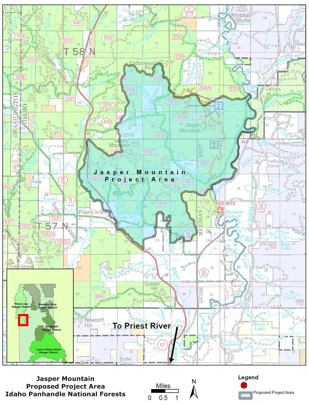
47
48 Jasper Mountain Project Area T5N-R5W T5N-R4W T57N-R5W T57N-R4W This produc t is reproduc edfrom geos patialinformationpreparedby theu.s.department ofagric ulturefores t Servic e.gisdataand produc t ac c urac y may vary.they may be:developedfrom s ourc es ofdiferingac c urac y,ac c urateonly at c ertains c ales,basedon modelingor interpretation,inc ompletewhilebeingc reatedor revised. Etc.UsingGISproduc ts for purpos es other thanthos efor ± whic hthey werec reatedmay yieldinac c urateor mis leadingresults. TheForest 32 s ervic ereserves theright 33 toc orrec t,update,modify,or replac egisproduc ts w ithout notific ation.for moreinformation, 27 Miles c ontac t theidahopanhandlenationalforests Supervis or s Ofic e Insect and Disease Risk PotentialMortality
49 Jasper Mountain Project Area T5N-R5W T5N-R4W T57N-R5W T57N-R4W This produc t is reproduc edfrom geos patialinformationpreparedby theu.s.department ofagric ulturefores t Servic e.gisdataand produc t ac c urac y may vary.they may be:developedfrom s ourc es ofdiferingac c urac y,ac c urateonly at c ertains 1994 c ales,basedon modelingor interpretation,inc ompletewhilebeingc reatedor revised. Etc.UsingGISproduc ts for purpos es other thanthos efor whic hthey werec reatedmay yieldinac c urateor mis leadingresults. TheForest 32 s ervic ereserves theright 33 toc orrec t,update,modify,or replac egisproduc ts w ithout notific ation.for moreinformation, Miles c ontac t theidahopanhandlenationalforests Supervis or s Ofic e ± Fire History

50 Jasper Mountain Project Area T5N-R5W T5N-R4W T57N-R5W T57N-R4W ± Fire Regime Condition Class Mo dera tedep a rture Miles HighDep a rture co nta cttheida ho Pa nha ndlena tio na lfo restssup erviso r sofice Thisp ro ductisrep ro ducedfro m geo sp a tia linfo rma tio np rep a redby theu.s.dep a rtmento fagriculturefo restservice.gisda ta a nd p ro ducta ccura cy ma y va ry.they ma y be:develo p edfro m so urces o fdiferinga ccura cy,a ccura teo nly a tcerta insca les,ba sedo n mo delingo r interp reta tio n,inco mp letewhilebeingcrea tedo r revised. Etc.UsingGISp ro ductsfo r p urp o seso ther tha ntho sefo r whichthey werecrea tedma y yieldina ccura teo r mislea dingresults. TheFo restservicereservestherightto co rrect,up da te,mo dify,o r rep la cegisp ro ductsw itho utno tifica tio n.fo r mo reinfo rma tio n,


51 Jasper Mountain Project Area T5N-R5W T5N-R4W T57N-R5W T57N-R4W This p roductis rep roducedfrom geos p atialinformationp rep aredb y theu.s.dep artmentofagriculturefores tservice.gisdataand p roductaccuracy may vary.they may b e:develop edfrom s ources ofdiferingaccuracy,accurateonly atcertains cales,b as edon modelingor interp retation,incomp letewhileb eingcreatedor revis ed. Etc.Us inggisp roducts for p urp os es other thanthos efor ± whichthey werecreatedmay yieldinaccurateor mis leadingres ults. TheFores 32 ts erviceres erves therighttocorrect,up 33 date,modify,or rep lacegisp roducts w ithoutnotification.for moreinformation, 27 Miles contacttheidahopanhandlenationalfores ts Sup ervis or s Ofice MANAGEMENT AREAS 30 Timb er Production Timb er Productionw ithinbiggamewinter Range Non-Fores tlands,lands non-s uited RNA 33


52 Jasper Mountain Project Area T5N-R5W T5N-R4W T57N-R5W T57N-R4W This p ro ductis rep ro ducedfro m geo sp a tia lin fo rma tio n p rep a redby theu.s.dep a rtmen to fagriculturefo restservice.gisda ta a n d p ro ducta ccura cy ma y va ry.they ma y be:develo p edfro m so urces o fdiferin ga ccura cy,a ccura teo n ly a tcerta in sca les,ba sedo n mo delin go r in terp reta tio n,in co mp letew hilebein gcrea tedo r revised. Etc.Usin ggisp ro ducts fo r p urp o ses o ther tha n tho sefo r ± whichthey werecrea tedma y yieldin a ccura teo r mislea din gresults. TheFo restservicereserves 32 therightto 33 co rrect,up da te,mo dify,o r rep la cegisp ro ducts w itho utn o tifica tio n.fo r mo rein fo rma tio n, Miles co n ta cttheida ho Pa n ha n dlena tio n a lfo rests Sup erviso r s Ofice STAND SIZE CLASS 20 Ma ture Imma ture Multisized Po le 29 Seedlin g/sa p lin g No n -sto cked No n -fo rest No Da ta
53 Jasper Mountain Project Area T5N-R5W T5N-R4W T57N-R5W T57N-R4W ± OLD GROWTH Miles OldGrow th c ontac t theidahopanhandlenationalforests Supervis or s Ofic e This produc t is reproduc edfrom geos patialinformationpreparedby theu.s.department ofagric ulturefores t Servic e.gisdataand produc t ac c urac y may vary.they may be:developedfrom s ourc es ofdiferingac c urac y,ac c urateonly at c ertains c ales,basedon modelingor interpretation,inc ompletewhilebeingc reatedor revised. Etc.UsingGISproduc ts for purpos es other thanthos efor whic hthey werec reatedmay yieldinac c urateor mis leadingresults. TheForest 32 s ervic ereserves theright 33 toc orrec t,update,modify,or replac egisproduc ts w ithout notific ation.for moreinformation, 33
54 Jasper Mountain Project Area T 5N-R5W T 5N-R4W T 57N-R5W T 57N-R4W T his productis reproducedfrom geospatial in form ation preparedby theu.s.departm en tofagricultureforestservice.gisdataan d productaccuracy m ay vary.t hey m ay be:developedfrom sources ofdiferin gaccuracy,accurateon ly atcertain scales,basedon m odelin gor in terpretation,in com pletew hilebein gcreatedor revised. Etc.Usin ggisproducts for purposes other than thosefor ± whichthey werecreatedm ay yieldin accurateor m isleadin gresults. T heforestservicereserves 32 therightto 33 correct,update,m odify,or replacegisproducts withoutn otification.for m orein form ation, Miles con tacttheidaho Pan han dlenation al Forests Supervisor s Ofice Forest Vegetation Type Birch,Green Ash,Boxelder,RedAlder Douglas fir Gran dfir Larch Lodgepolepin e 30 Non -Forest 29 2 Pon derosapin e Spruce/Subalpin efir Un k n ow n Western RedCedar Western WhitePin e Western hem lock
55 Jasper Mountain Project Area T5N-R5W T5N-R4W T57N-R5W T57N-R4W This p roductis rep roducedfrom geos p atialinformationp rep aredb y theu.s.dep artmentofagriculturefores tservice.gisdataand p roductaccuracy may vary.they may b e:develop edfrom s ources ofdiferingaccuracy,accurateonly atcertains cales,b as edon modelingor interp retation,incomp letewhileb eingcreatedor revis ed. Etc.Us inggisp roducts for p urp os es other thanthos efor ± whichthey werecreatedmay yieldinaccurateor mis leadingres ults. TheFores 32 ts erviceres erves therighttocorrect,up 33 date,modify,or rep lacegisp roducts w ithoutnotification.for moreinformation, Miles contacttheidahopanhandlenationalfores ts Sup ervis or s Ofice ftStream Bu fer


56 Jasper Mountain Project Area T5N-R5W T5N-R4W T57N-R5W T57N-R4W Thisp ro ductisrep ro ducedfro m geo sp a tia linfo rma tio np rep a redby theu.s.dep a rtmento fagriculturefo restservice.gisda ta a nd p ro ducta ccura cy ma y va ry.they ma y be:develo p edfro m so urces o fdiferinga ccura cy,a ccura teo nly a tcerta insca les,ba sedo n mo delingo r interp reta tio n,inco mp letewhilebeingcrea tedo r revised. Etc.UsingGISp ro ductsfo r p urp o seso ther tha ntho sefo r ± whichthey werecrea tedma y yieldina ccura teo r mislea dingresults. TheFo restservicereservestherightto co rrect,up da te,mo dify,o r rep la cegisp ro ductsw itho utno tifica tio n.fo r mo reinfo rma tio n, 27 Miles co nta cttheida ho Pa nha ndlena tio na lfo restssup erviso r sofice Mass Failure Potential 30 High Mo dera te Lo w
3-13 Other Required Findings and Regulatory Compliance
 Affected Environment and Environmental Consequences 3-13 Other Required Findings and Regulatory Compliance 3-13.1 Short-term Uses and Long-term Productivity NEPA requires consideration of the relationship
DECISION MEMO. West Fork Blacktail Deer Creek Hardened Crossing
 Page 1 of 6 Background DECISION MEMO USDA Forest Service Madison Ranger District Madison County T12S, R4W, Section 30 The project is in the Gravelly Landscape, Snowcrest Recommended Wilderness Management
Introduction. Methodology for Analysis
 Scenic Report Prepared by: /s/gary Kedish Natural Resources Specialist for: Warner Mountain Ranger District Modoc National Forest January 20, 2016 Introduction This report focuses on the Visual Quality
Introduction. Methodology for Analysis
 1 Medicine Lake Caldera Vegetation Treatment Project Scenic Report Prepared by: /s/gary Kedish Natural Resources Specialist for: Big Valley and Doublehead Ranger Districts Modoc National Forest February
DECISION NOTICE AND FINDING OF No SIGNIFICANT IMPACT HOPKINS FIRE SALVAGE
 DECISION NOTICE AND FINDING OF No SIGNIFICANT IMPACT HOPKINS FIRE SALVAGE DECISION U.S. FOREST SERVICE OCALA NATIONAL FOREST SEMINOLE RANGER DISTRICT MARION COUNTY, FLORIDA Based upon my review of the
Wildlife Conservation Strategy
 Wildlife Conservation Strategy Boise National Forest What is the Wildlife Conservation Strategy? The Boise National Forest is developing a Wildlife Conservation Strategy (WCS) in accordance with its Land
The Galton Project Kootenai National Forest. The Galton Project
 Introduction The Galton Project The Fortine Ranger District of the Kootenai National Forest is in the early stages of developing a project entitled Galton, named for the mountain range dominating the eastern
PRESCRIBED FIRE IN SOUTHWEST IDAHO
 2016 PRESCRIBED FIRE IN SOUTHWEST IDAHO In southwest Idaho, public land managers work to: address public health and safety concerns; treat insect and disease infestations; reduce the risk of severe wildfires
The project will be conducted in partnership with the Nez Perce Tribe.
 DECISION MEMO Tributary to Brushy Fork Culvert Replacements Private Land USDA Forest Service, Northern Region Powell Ranger District Nez Perce Clearwater National Forests Idaho County, Idaho I. Decision
Public Notice. Applicant: City of Dallas Project No.: SWF Date: April 18, Name: Chandler Peter Phone Number:
 Public Notice Applicant: City of Dallas Project No.: SWF- 2014-00151 Date: April 18, 2014 The purpose of this public notice is to inform you of a proposal for work in which you might be interested. It
SKIBO PROJECT SCOPING REPORT Laurentian Ranger District, Superior National Forest
 SKIBO PROJECT SCOPING REPORT Laurentian Ranger District, Superior National Forest I. Introduction The Laurentian Ranger District of the Superior National Forest is proposing management activities within
Preparing a Community Wildfire Protection Plan
 Preparing a Community Wildfire Protection Plan A Handbook for Wildland Urban Interface Communities Sponsored By: Communities Committee National Association of Counties National Association of State Foresters
Proposed Action Report Big Creek WBP Enhancement Project
 Proposed Action Report Big Creek WBP Enhancement Project USDA Forest Service Cascade Ranger District Boise National Forest Valley County, Idaho July 2013 PURPOSE AND NEED FOR THE PROPOSED ACTION The encroachment
West Branch LeClerc Creek Watershed Restoration Project Environmental Assessment
 West Branch LeClerc Creek Watershed Restoration Project Environmental Assessment Decision Notice, Finding of No Significant Impact, and Response to Public Comments April 2015 USDA Forest Service Colville
Fontana Project Scoping Record August 2013
 Fontana Project Scoping Record August 2013 The Cheoah Ranger District, Nantahala National Forest, is conducting an interdisciplinary analysis of a proposed project, called the Fontana Project, in Graham
Appendix C. Activity Codes
 Appendix C Activity Codes Activity Code Groupings 1000 Fire 2000 - Range 3000 Cultural Resources and Recreation 4000 Timber and Silviculture 5000 Soil, Air and Watershed 6000 Wildlife; Threatened, Endangered,
Rennic Stark Visual Quality Report March 31, 2011 (edited January 9, 2012) /s/ Norma E. Staaf, Forest Landscape Architect
 /s/ Norma E. Staaf, Forest Landscape Architect") Rennic Stark Visual Quality Report March 31, 2011 (edited January 9, 2012) /s/ Norma E. Staaf, Forest Landscape Architect 1 Table of Contents AFFECTED ENVIRONMENT... 3 Forest Plan Direction and Regulatory
Rennic Stark Visual Quality Report March 31, 2011 (edited January 9, 2012) /s/ Norma E. Staaf, Forest Landscape Architect 1 Table of Contents AFFECTED ENVIRONMENT... 3 Forest Plan Direction and Regulatory
FOREST SERVICE MANUAL NATIONAL HEADQUARTERS (WO) WASHINGTON, DC
 WASHINGTON, DC") Page 1 of 13 FOREST SERVICE MANUAL NATIONAL HEADQUARTERS (WO) WASHINGTON, DC CHAPTER 2500 ZERO CODE Amendment No.: 2500-2010-2 Effective Date: November 23, 2010 Duration: This amendment is effective until
Page 1 of 13 FOREST SERVICE MANUAL NATIONAL HEADQUARTERS (WO) WASHINGTON, DC CHAPTER 2500 ZERO CODE Amendment No.: 2500-2010-2 Effective Date: November 23, 2010 Duration: This amendment is effective until
Mechanical Site Preparation
 Mechanical Site Preparation 1 Mechanical Site Preparation Introduction...3 CONTENTS The Benefits of Guidelines...3 Considerations...5 Design Outcomes To Maintain Soil Productivity...6 Planning...7 Planning
Joint Public Notice. LOCATION: In Salmon Bay, Lake Washington Ship Canal, at Seattle, Washington.
 US Army Corps of Engineers Seattle District Joint Public Notice Application for a Department of the Army Permit and a Washington Department of Ecology Water Quality Certification and/or Coastal Zone Management
FOREST, WETLANDS AND HABITAT
 FOREST, WETLANDS AND HABITAT A SYST FOR FOREST, WETLANDS AND HABITAT LANDOWNERS FAS 115 October 2017 Major Revision Destroy Old For MAEAP Verification: Contact the MAEAP Office at the Michigan Department
PLANT AND ANIMAL DIVERSITY
 by the planning rule team as of. These ideas are for discussion purposes and do not What we want to achieve PLANT AND ANIMAL DIVERSITY The Forest Service is committed to protecting species and sustaining
Wind Energy Development Specialist Report
 United States Department of Agriculture Forest Service Southwestern Region Cibola National Forest and National Grasslands Wind Energy Development Specialist Report Kiowa, Rita Blanca, Black Kettle and
Preliminary Decision Memo 2015 Recreation Residence Projects Odell Lake
 2015 Recreation Residence Projects Odell Lake USDA Forest Service Crescent Ranger District, Deschutes National Forest Klamath County, Oregon Background The Crescent Ranger District maintains 66 recreation
POLICY FOR NATURAL RESOURCE MANAGEMENT AREAS
 POLICY FOR NATURAL RESOURCE MANAGEMENT AREAS I. POLICY STATEMENT Auburn University's (the University's) "Policy for Natural Resource Management Areas" implements the Campus Master Plan Land Use Element
Natural Resource Management of Pipeline Infrastructure
 Natural Resource Management of Pipeline Infrastructure Dan Devlin Director, Bureau of Forestry www.dcnr.state.pa.us Connection between Pipelines & DCNR Commonwealth s forests Fragmentation or reduction
Blanche Park Reservoir Decision Notice and Finding of No Significant Impact
 Blanche Park Reservoir Decision Notice and Finding of No Significant Impact U.S. Forest Service Grand Mesa, Uncompahgre, and Gunnison National Forests Delta County, Colorado INTRODUCTION The Grand Mesa
DECISION MEMO. Non-Commercial Thinning on the Ocala National Forest (PALS project # 39238)
") Decision DECISION MEMO Non-Commercial Thinning on the Ocala National Forest (PALS project # 39238) USDA Forest Service Ocala National Forest Lake, Marion, and Putnam County, Florida Based on the analysis
Decision DECISION MEMO Non-Commercial Thinning on the Ocala National Forest (PALS project # 39238) USDA Forest Service Ocala National Forest Lake, Marion, and Putnam County, Florida Based on the analysis
SAN LUIS VALLEY PUBLIC LANDS CENTER
 Decision Notice And Finding of No Significant Impact Watershed and Fisheries Conservation Treatments SAN LUIS VALLEY PUBLIC LANDS CENTER USDA Forest Service Rocky Mountain Region Public Lands Center Rio
Ochoco, Umatilla, Wallowa-Whitman National Forests; Oregon and Washington; Blue Mountains
 [3410-11- P] DEPARTMENT OF AGRICULTURE Forest Service Ochoco, Umatilla, Wallowa-Whitman National Forests; Oregon and Washington; Blue Mountains Forest Resiliency Project AGENCY: Forest Service, USDA. ACTION:
Memorandum of Understanding On Policy Principles For
 Memorandum of Understanding On Policy Principles For Woody Biomass Utilization for Restoration and Fuel Treatments On Forests, Woodlands, and Rangelands United States Department of Agriculture And United
Keefer Pasture Drift Fence Project. Challis-Yankee Fork Ranger District Salmon-Challis National Forest
 Keefer Pasture Drift Fence Project Challis-Yankee Fork Ranger District Salmon-Challis National Forest PROPOSED ACTION The Challis-Yankee Fork Ranger District proposes construction of approximately.11 miles
Visual Management System and Timber Management Application 1
 Visual Management System and Timber Management Application 1 2 Warren R. Bacon and Asa D. (Bud) Twombly / Abstract: This paper includes an illustration of a planning process to guide vegetation management
PG&E Transmission Lines Hazard Tree Removal and Salvage Project
 PG&E Transmission Lines Hazard Tree Removal and Salvage Project Hydrology Effects Analysis Report Zack Mondry, Hydrologist (PH) USFS ACT2 Enterprise Unit Executive Summary Analysis of the proposed Humboldt/Trinity
Kreist Creek. Environmental Assessment. United States Department of Agriculture Forest Service
 United States Department of Agriculture Forest Service Kreist Creek Environmental Assessment Bonners Ferry Ranger District, Idaho Panhandle National Forests, Boundary County, Idaho May 2014 For More Information
STREAM AND BUFFER AREA PROTECTION/RESTORATION
 STREAM AND BUFFER AREA PROTECTION/RESTORATION AMENDMENT OPTIONS TO STRENGTHEN POLICY IN HEADWATERS AREAS DRAFT SUBSEQUENT TO THE JANUARY 25, 2007 MEETING OF THE PLANNING COMMISSION ENVIRONMENT COMMITTEE
Lakeview Stewardship CFLRP Work Plan 2012
 Responses to the prompts on this work plan should be typed directly into this template 1. Describe the manner in which the proposal will be implemented to achieve ecological and community economic benefit,
Draft Decision Notice and Finding of No Significant Impact (DN/FONSI)
") United States Department of Agriculture Forest Service January 2016 Draft Decision Notice and Finding of No Significant Impact (DN/FONSI) Rock Creek Vegetation and Fuels Healthy Forest Restoration Act
United States Department of Agriculture Forest Service January 2016 Draft Decision Notice and Finding of No Significant Impact (DN/FONSI) Rock Creek Vegetation and Fuels Healthy Forest Restoration Act
DECISION MEMO Divide Creek Barrier Enhancement
 Page 1 of 7 Background DECISION MEMO USDA Forest Service Butte Ranger District Silver Bow County, Montana T. 2 N., R. 9 W., Section 32 The North Fork of Divide Creek is approximately 4 miles west of the
Proposed Action for Motorized Travel Management on the North Kaibab Ranger District
 United States Department of Agriculture Forest Service Proposed Action for Motorized Travel Management on the North Kaibab Ranger District Kaibab National Forest March 2010 The U.S. Department of Agriculture
Idaho Panhandle National Forests Watershed Specialist Review. Extraordinary Circumstances Review: Floodplains, Wetlands, Municipal Watersheds
 Idaho Panhandle National Forests Watershed Specialist Review Project: Idaho Buckhorn Restoration Burn Date: June 10, 2013 Extraordinary Circumstances Review: Floodplains, Wetlands, Municipal Watersheds
Big Hill Insect and Disease Project Proposed Action
 Big Hill Insect and Disease Project Proposed Action Project Background and 2014 Farm Bill The Big Hill Insect and Disease project on the Challis-Yankee Fork Ranger District of the Salmon-Challis National
MODULE 5: ECOLOGICAL IMPACTS
 MODULE 5: ECOLOGICAL IMPACTS Purpose This module describes measures for ecological restoration and rehabilitation efforts. The module is primarily focused on fire hazard reduction and its ecological effects.
MONITORING QUESTIONS AND TASKS FOR THE GEORGE WASHINGTON PLAN
 MONITORING QUESTIONS AND TASKS FOR THE GEORGE WASHINGTON PLAN MONITORING THEME 1 CONSERVATION OF BIOLOGICAL DIVERSITY FOR ECOSYSTEMS MQ 1: How are ecological conditions maintaining or making progress toward
DEPARTMENT OF ENVIRONMENTAL PROTECTION Bureau of Water Quality Protection. Design Criteria - Wetlands Replacement/Monitoring
 DEPARTMENT OF ENVIRONMENTAL PROTECTION Bureau of Water Quality Protection DOCUMENT NUMBER: 363-0300-001 TITLE: Design Criteria - Wetlands Replacement/Monitoring EFFECTIVE DATE: February 11, 1997 AUTHORITY:
Appendix 1 Hood River Stewardship Crew Collaborative Recommendations
 Appendix 1 Hood River Stewardship Crew Collaborative Recommendations July 24, 2014 Hood River Collaborative Stew Crew Objectives/Priorities: Protect the integrity of and access to recreational trails and
Sustainable Non-Agriculture Land Management
 Forest, Wetlands and Habitat Verification Checklist A boxed risk level indicates the level required for environmental assurance verification. Bold black print indicates a violation of state or federal
Idaho Panhandle National Forests
 United States Department of Agriculture Forest Service Idaho Panhandle National Forests Sandpoint Ranger District 1602 Ontario Road Sandpoint, ID 83864-9509 (208)263-5111 File Code: 1950 Date: July 14,
Katahdin Forest Management 2016 SFI Summary Audit Report
 Katahdin Forest Management 2016 SFI Summary Audit Report Introduction The SFI Program of Katahdin Forest Management of Millinocket, Maine has demonstrated continued conformance with the SFI 2015-2019 Standard
Department of the Army Permit Application
 Department of the Army Permit Application DA File Number U.S. Army Corps of Engineers Honolulu District Date Received by CEPOH-RO Send Completed Application to: Honolulu District, U.S. Army Corps of Engineers
Decision Memo Tongass National Forest. Wrangell Ranger District. Pre-Commercial Thinning CE 2010
 Decision Memo Tongass National Forest Pre-Commercial Thinning CE 2010 Decision It is my decision to authorize pre-commercial thinning (PCT) on approximately 7,500 acres of overstocked young-growth forest
Hydrology Specialist Report. ROCK CREEK FUELS AND VEGETATION MANAGEMENT ANALYSIS Minidoka Ranger District
 Sawtooth National Forest Hydrology Specialist Report ROCK CREEK FUELS AND VEGETATION MANAGEMENT ANALYSIS Minidoka Ranger District Mark Dallon Hydrologist, Minidoka Ranger District /s/ Mark Dallon 9/22/2015
Hat Creek Planning Unit. Fish, Plant, and Wildlife Habitat. LCP Volume II Supporting Analysis for Recommendations
 Hat Creek Planning Unit Fish, Plant, and Wildlife Habitat Conduct surveys of the planning unit to identify biological resources and enable their protection. Though a partial survey of botanical resources
Nationwide Permit General Conditions
 Nationwide Permit General Conditions Note: To qualify for NWP authorization, the prospective permittee must comply with the following general conditions, as applicable, in addition to any regional or case-specific
Erosion & Sedimentation Control Policy
 Issue Date 10/22/2010 Page 1 of 8 Erosion & Sedimentation Control Policy Introduction: Soil erosion is the removal of soil by water, wind, ice or gravity and sediment deposition occurs when the rate of
Lake Britton Planning Unit. Fish, Plant, and Wildlife Habitat LAKE BRITTON PLANNING UNIT
 LAKE BRITTON PLANNING UNIT Pit-McCloud River Watershed Lake Britton Planning Unit Fish, Plant, and Wildlife Habitat Conduct surveys of lands outside the FERC boundary to identify biological resources and
Chapter 1. Purpose and Need for Action
 Final Environmental Impact Statement Plumas National Forest Chapter 1. Purpose and Need for Action Document Structure The Forest Service has prepared this Final Environmental Impact Statement (FEIS) in
WISCONSIN. Enforceable Provisions Applicable to Nonpoint Source Water Pollution DISCHARGE PROHIBITIONS
 WISCONSIN Enforceable Provisions Applicable to Nonpoint Source Water Pollution Water Pollution Control Law DISCHARGE PROHIBITIONS Wisconsin s water pollution law does not contain a general discharge prohibition.
3.1 Forest Vegetation and Wildlife Habitat
 3.1 Forest Vegetation Echo Trail Area Forest Management Project Forest vegetation and wildlife habitat analyses are based on data contained in a Region 9 program referred to as CDS (Combined Data System).
Environmental Assessment
 United States Department of Agriculture Forest Service March 2010 East Fork Meadow Creek Environmental Assessment Bonners Ferry Ranger District Idaho Panhandle National Forests The U.S. Department of Agriculture
MANTI-LA SAL NATIONAL FOREST
 MANTI-LA SAL NATIONAL FOREST FERRON RANGER DISTRICT CATEGORICAL EXCLUSION REVIEW FILE NUMBER: 2240 PROJECT TITLE: Olsen-McCadden Livestock Water Development PROJECT LEAD: Steven Cox ESTIMATED DATE FOR
Summary Alternative 1 No Action
 Summary The Sierra National Forest, Bass Lake Ranger District proposes to create a network of strategically placed landscape area treatments (SPLATs) and defensible fuels profiles near key transportation
Municipal Stormwater Management Planning
 Municipal Stormwater Management Planning Christopher C. Obropta, Ph.D., P.E. Water Resources Extension Specialist with Rutgers Cooperative Extension Assistant Professor with Department of Environmental
For the property described as: Property Owner: Name. Phone Number. Mailing Address. City. Report Year:
 Timber Management Plan For the property described as: Property Owner: Name Phone Number Mailing Address City State Zip Report Year: (This template is provided to assist Cherokee County land owners who
Chapter 13: Wildlife and Vegetation
 Chapter 13: Wildlife and Vegetation Introduction and Setting Nevada County contains an extremely wide range of plants, animals and habitat types. With topographic elevations ranging from 300 feet in the
Notice No Closing Date: May 12, 2017
 Public Notice U.S. Army Corps of Engineers Pittsburgh District In Reply Refer to Notice No. below US Army Corps of Engineers, Pittsburgh District 1000 Liberty Avenue Pittsburgh, PA 15222-4186 Application
New Mexico Forest Restoration Principles
 New Mexico Forest Restoration Principles Preamble These principles were collaboratively developed by a team of dedicated professionals representing industry, conservation organizations, land management
Telegraph Forest Management Project
 Telegraph Forest Management Project Black Hills National Forest Northern Hills Ranger District Lawrence and Pennington Counties, South Dakota Proposed Action and Request for Comments March 2008 Table of
CHAPTER 6 ADDITIONAL STANDARDS APPLYING TO SHORELAND AREAS AND PUBLIC WATERS
 CHAPTER 6 ADDITIONAL STANDARDS APPLYING TO SHORELAND AREAS AND PUBLIC WATERS Section 1 Intent. 49 Section 2 Floodplain Requirements 49 Section 3 Water-Oriented Accessory Structures 50 Section 4 Stairways,
Public Notice. Applicant: Lennar Homes Project No.: SWF Date: October 29, Name: Mr. Darvin Messer Phone Number:
 Public Notice Applicant: Lennar Homes Project No.: SWF-2013-00265 Date: October 29, 2013 The purpose of this public notice is to inform you of a proposal for work in which you might be interested. It is
Public Rock Collection
 Public Rock Collection Eagle-Holy Cross Ranger District, White River national Forest Eagle County, Colorado T7S, R80W, Section 18 & T6S, R84W, Section 16 Comments Welcome The Eagle-Holy Cross Ranger District
La Grande Ranger District
 La Grande Ranger District Wallowa-Whitman National Forest 3502 Highway 30, La Grande, OR. 97850 (541) 963-7186 January 15, 2015 Dear Forest User: The La Grande Ranger District has recently completed a
James Creek Fuel Reduction Project Decision Notice & Finding of No Significant Impact
 James Creek Fuel Reduction Project Decision Notice & Finding of No Significant Impact Introduction USDA Forest Service Arapaho-Roosevelt National Forests And Pawnee National Grassland Boulder Ranger District
Chapter 10 Natural Environment
 Chapter 10 Natural Environment Existing Conditions The Natural Environment Element addresses the protection, conservation, preservation, and restoration of the natural resources the Bayview Ridge Subarea,
WETLANDS AND OPEN WATERS Compensatory Mitigation Definitions of Factors
 Adverse effects as used in this section of the SOP means any adverse ecological effect on wetlands or areas of open water. Those effects, or impacts, include filling, excavating, flooding, draining, clearing,
MANITOBA ENVIROTHON WATER AND AQUATIC ECOSYSTEMS
 MANITOBA ENVIROTHON WATER AND AQUATIC ECOSYSTEMS Outcome Water and Aquatic Ecosystems as Resources Properties of Water, Water Bodies and Watersheds, and Aquatic Species Identification A1 A2 A3 A4 A5 A6
Lesson 2-2: Riparian Zones
 2-14 Lesson 2-2: Riparian Zones Time of Lesson: 1 hour Rationale: The purpose of this lesson is to define what a riparian zone is and link its importance for fish and other animals, and humans, and the
CHAPTER 3 Environmental Guidelines for WATERCOURSE CROSSINGS GOVERNMENT OF NEWFOUNDLAND AND LABRADOR DEPARTMENT OF ENVIRONMENT AND LABOUR
 GOVERNMENT OF NEWFOUNDLAND AND LABRADOR DEPARTMENT OF ENVIRONMENT AND LABOUR CHAPTER 3 Environmental Guidelines for WATERCOURSE CROSSINGS WATER RESOURCES MANAGEMENT DIVISION Water Investigations Section
Appendix G: Alternative Sent by the Karuk Tribe
 Draft Environmental Impact Statement Westside Fire Recovery Project Appendix G: Alternative Sent by the Karuk Tribe 440 Westside Fire Recovery Project Draft Environmental Impact Statement 441 Draft Environmental
Instructions for the South Pacific Division Nationwide Permit Pre- Construction Notification (PCN):
:") This PCN integrates the requirements of the U.S. Army Corps of Engineers (Corps) Nationwide Permit Program within the South Pacific Division (SPD), including the Albuquerque, Los Angeles, San Francisco,
This PCN integrates the requirements of the U.S. Army Corps of Engineers (Corps) Nationwide Permit Program within the South Pacific Division (SPD), including the Albuquerque, Los Angeles, San Francisco,
Chapter 4 Watershed Goals and Objectives
 Chapter 4 Watershed Goals and Objectives Eight (8) long-term watershed goals have been developed by the NEW Watershed Advisory Group (WAG) after consideration of discussions held during monthly watershed
Ashland Tree Planting Project
 DECISION MEMO Ashland Tree Planting Project Ashland Ranger District Custer National Forest USDA Forest Service Powder River and Rosebud Counties, Montana Purpose and Need for Proposing Action Forest cover
RIPARIAN PROTECTION Questions & Answers
 RIPARIAN PROTECTION Questions & Answers 1. What is a riparian corridor and why is it important? Answer: A riparian corridor is a space on both sides of a stream or around a lake or wetland. The corridor
Overview of the Clean Water Act and Water Quality Standards
 Overview of the Clean Water Act and Water Quality Standards TLEF, August 17, 2015 Heather Goss, USEPA, Water Quality Standards program (standing in for Tom Gardner) 1 Today s goal Provide a basic introduction
Natural Resources and Climate Resiliency in Germantown
 Natural Resources and Climate Resiliency in Germantown Ingrid Haeckel, Andrew Meyer, and Elizabeth Murphy NYSDEC Hudson River Estuary Program and Cornell University Presentation to the Town of Germantown,
NESST- National Ecosystem Services Strategy Team
 NESST- National Ecosystem Services Strategy Team Robert Deal, Emily Weidner, Mary Snieckus, Tommie Herbert, Jonas Epstein, Tania Ellersick, Krista Gebert, Nikola Smith, Greg Arthaud Overview Ecosystem
VIDEO: Riparian Forest Buffers: The Link Between Land & Water
 VIDEO: Riparian Forest Buffers: The Link Between Land & Water Introduction to Riparian Buffers Adapted from: Riparian Forest Buffers: The Link Between Land & Water. Maryland Cooperative Extension. Wye
Chapter 3 Affected Environment and Environmental Consequences
 Sterling Highway MP 45 60 Draft SEIS and Draft Section 4(f) Evaluation Chapter 3 Affected Environment and Environmental Consequences Prepared for: Alaska Department of Transportation and Public Facilities
SECTION 2. SFI Forest Management Standard
 SECTION 2 SFI 2015-2019 Forest Management Standard January 2015 SFI 2015-2019 Forest Management Standard 1. General 2 1.1 Scope 2 1.2 Additional Requirements 2 1.3 References 2 1.4 Forest Management Standard
TORCH LAKE TOWNSHIP WATER QUALITY ACTION PLAN
 TORCH LAKE TOWNSHIP WATER QUALITY ACTION PLAN Elk-River-Chain-of-Lakes Gaps Analysis Project The Watershed Center Grand Traverse Bay Tip of the Mitt Watershed Council Michigan Department of Natural Resources
Environmental Information Worksheet
 Environmental Information Worksheet Water System Owner (Attach additional sheets if necessary) Needs and Alternatives Provide a brief narrative that describes: Current drinking water system needs. Project
LAND DEVELOPMENT AND PLANNING FORUM 2014 THE 2014 PROVINCIAL POLICY STATEMENT AND ENVIRONMENTAL PROTECTION
 LAND DEVELOPMENT AND PLANNING FORUM 2014 THE 2014 PROVINCIAL POLICY STATEMENT AND ENVIRONMENTAL PROTECTION MARY L. FLYNN-GUGLIETTI AND ANNIK FORRISTAL THE 2014 PROVINCIAL POLICY STATEMENT & ENVIRONMENTAL
Siting Guidelines for Windpower Projects in Kansas
 Siting Guidelines for Windpower Projects in Kansas The Kansas Renewable Energy Working Group Environmental and Siting Committee Introduction The Environmental and Siting Committee of the Kansas Renewable
Decision Notice and Finding of No Significant Impact
 Decision Notice and Finding of No Significant Impact Gold Lake Bog Research Natural Area Boundary Adjustment and Nonsignificant Forest Plan Amendment #53 USDA Forest Service Middle Fork Ranger District,
Craggy Vegetation Management Project
 Craggy Vegetation Management Project Salmon/Scott River Ranger District Klamath National Forest Siskiyou County, California The Klamath National Forest proposes the Craggy Vegetation Management Project
Understanding Stormwater Pollution Prevention Plans (SWPPPs) (SWPPPS)
 (SWPPPS)") Understanding Stormwater Pollution Prevention Plans (SWPPPs) (SWPPPS) Definitions SWPPP: Storm Water Pollution Prevention Plan BMP: Best Management Practice(s) to control pollution IDNR: Iowa Department
Understanding Stormwater Pollution Prevention Plans (SWPPPs) (SWPPPS) Definitions SWPPP: Storm Water Pollution Prevention Plan BMP: Best Management Practice(s) to control pollution IDNR: Iowa Department
NEW Vision 2020 CFLRP Work Plan Template 2012
 Responses to the prompts on this work plan should be typed directly into this template 1. Describe the manner in which the proposal will be implemented to achieve ecological and community economic benefit,
STATE OF MINNESOTA MINNESOTA POLLUTION CONTROL AGENCY
 STATE OF MINNESOTA MINNESOTA POLLUTION CONTROL AGENCY In the Matter of the Decision on the Need for an Environmental Impact Statement for the Proposed Remer Wastewater Treatment Facility Expansion FINDINGS
Forsythe II Project. September 2015
 Forsythe II Project September 2015 The Boulder Ranger District (BRD) of the Arapaho and Roosevelt National Forests is proposing vegetation treatments on 3,840 acres of National Forest System (NFS) lands