Terrestrial Laser Scanning: Can we see the wood for the trees. Kenneth Olofsson SLU
|
|
|
- Beverly Tyler
- 6 years ago
- Views:
Transcription

1 Terrestrial Laser Scanning: Can we see the wood for the trees Kenneth Olofsson SLU

2 Terrestrial laser scanning (TLS) A laser scanner placed in the area of interest scans 360º, resulting in a 3D point cloud Signal analysis techniques can be used to derive forestry parameters from the 3D point cloud
3 Why use TLS data? Could make field inventory more efficient and reduce the risk of errors due to the human factor An increased amount of information from the field survey The positions of the tree stems can be derived for co-registration with airborne data
 Stem profile Tree height Volume Stem shapes Branch structure Leaf area")
4 Forestry parameters extracted from TLS-data Tree position Stem diameter (dbh) Stem profile Tree height Volume Stem shapes Branch structure Leaf area index

5 Extract trees from TLS data
6 TLS results Stem profile RMSE ~1 cm Kenneth Olofsson and Johan Holmgren Single Tree Stem Profile Detection Using Terrestrial Laser Scanner Data, Flatness Saliency Features and Curvature Properties Forests 2016, 7(9), 207; doi: /f

7 Single/multiple scan setup A: Single scan Pro:Short scanning time, Easy to use Con: Shading of trees B: Multiple scan Pro: High point density, Small amount of shading Con: Accurate co-registration necessary. Scanning time is long

8 Simulated TLS field plot

9 Examples of shading of stems in TLS field plots The whole stem is visible At least half of the stem is visible At least a small part of the stem is visible The center of the stem is visible The left edge of the stem is visible The right edge of the stem is visible The stem is shaded

10 Shaded area in TLS plots
11 Shaded area in TLS plots
12 Estimating stems/ha
13 Estimating stems/ha
14 Estimating stems/ha
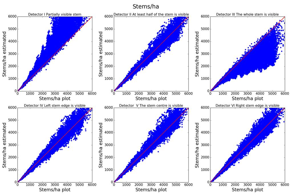
15 Estimating stems/ha

16 Stem diameter distributions

17 Stem diameter distributions

18 Gaussian stem diameter distribution

19 Clustered positions of the trees, Gaussian stem diameter distribution
20 References Aschoff, T., Thies, M., and Spiecker, H., 2004, Describing forest Stands using Terrestrial Laserscanning. In proceedings of the XXth ISPRS Congress, July 12-23, 2004, Istanbul, Turkey, Aschoff, T. and Spiecker, H., Algorithms for the automatic detection of trees in laser scanner data. In proceedings of the ISPRS workshop Laser-Scanners for Forest and Landscape Assessment, October 3-6, 2004, Freiburg, Germany. Bienert, A., Scheller, S., Keane, E., Mohan, F., and Nugent, C., 2007, Tree Detection and Diameter Estimations by Analysis of Forest Terrestrial Laserscanner Point Clouds. In proceedings of the ISPRS Workshop on Laser Scanning 2007 and SilviLaser 2007, Espoo, September 12-14, 2007, Finland, Brolly, G. and Király, G., Algorithms for Stem Mapping by Means of Terrestrial Laser Scanning. Acta Silv. Lign. Hung., Vol. 5 (2009) Chum, O., Two-View Geometry Estimation by Random Sampling and Consensus. PhD-thesis. Center for Machine Perception Department of Cybernetics Faculty of Electrical Engineering Czech Technical University in Prague.
21 References 2 Erikson, M. and Vestlund, K Finding tree stems in laser range images of young mixed stands to perform selective cleaning. Scandlaser 2003, Umeå Sweden. Forsman, P. and Halme, A., D Mapping of Natural Environments With Trees by Means of Mobile Perception. IEEE transactions on robotics, vol. 21, no. 3, june Gorte, B. and Winterhalder, D., Reconstruction of laser-scanned trees using filter operations in the 3d raster domain. In proceedings of the ISPRS workshop Laser-Scanners for Forest and Landscape Assessment, October 3-6, 2004, Freiburg, Germany. Haala, N.,, R., Thies, M., and Aschoff, T., 2004, Combination of terrestrial laser scanning with high resolution panoramic images for investigations in forest applications and tree species recognition. In proceedings of the ISPRS Panoramic Photogrammetry Workshop, February 19-22, 2004, Dresden, Germany. Henning, J.G. and Radtke, P.J., 2006, Detailed stem measurements of standing trees from ground-based scanning lidar. Forest Science, 52,
22 References 3 Hopkinson, C., Chasmer, L., Young-Pow, C., and Treitz, P., 2004, Assessing forest metrics with a ground-based scanning lidar. Canadian Journal of Forest Research-Revue Canadienne de Recherche Forestiere, 34, Hosoi, F, and Omasa, K, Voxel-Based 3-D Modeling of Individual Trees for Estimating Leaf Area Density Using High-Resolution Portable Scanning Lidar. IEEE Transactions on geoscience and remote sensing, vol. 44, no. 12, Liang, X Litkey, P, Hyyppä, J, Kaartinen, H., Vastaranta, M., and Holopainen, M., Automatic stem location mapping using TLS for plot-wise forest inventory. SilviLaser 2009, Oct , 2009 College Station, Texas, USA. Lindberg, E., Holmgren, J., Olofsson, K., and Olsson, H., Estimation of stem attributes using a combination of terrestrial and airborne laser scanning. Silvilaser 2010, Freiburg, Tyskland. Olofsson, K., E. Lindberg and Holmgren, J., A method for linking field-surveyed and aerial-detected single trees using cross correlation of position images and the optimization of weighted tree list graphs. SilviLaser 2008, 8th international conference on LiDAR applications in forest assessment and inventory., Heriot-Watt University, Edinburgh, UK, SilviLaser 2008 Organizing Committee, Edinburgh: Forest Research. Olofsson, K., and Holmgren, J. Single Tree Stem Profile Detection Using Terrestrial Laser Scanner Data, Flatness Saliency Features and Curvature Properties. Forests 2016, 7(9)
23 References 4 Pfeifer, N. and Winterhalder, D., 2004, Modelling of Tree Cross Sections from Terrestrial Laser-Scanning Data with Free-Form Curves. In proceedings of the ISPRS workshop Laser-Scanners for Forest and Landscape Assessment, October 3-6, 2004, Freiburg, Germany. Raumonen, P., Kaasalainen, M., Åkerblom, M., Kaasalainen, S., Kaartinen, H., Vastaranta, M., Holopainen, M., Disney, M. and Lewis, P.,. Fast Automatic Precision Tree Models from Terrestrial Laser Scanner Data. Remote Sensing, 2013, 5(2), Shan, J. and Toth, C, Topographic laser ranging and scanning. Principles and processing. Taylor & Francis Group, London New York. Simonse, M., Aschoff, T., Spiecker, H. and Thies, M Automatic determination of forest inventory parameters using terrestrial laser scanning. Proceedings of the ScandLaser Scientific Workshop on Airborne Laser Scanning of Forests, Umea, Sweden, 3 Á/4 September 2003, pp. 252 Á/258. ISSN 1401 Á/1204. Tanaka, T., Yamaguchi, J., and Takeda, Y., 1998, Measurement of forest canopy structure with a laser plane range-finding method - development of a measurement system and applications to real forests. Agricultural and Forest Meteorology, 91, Tanaka, T., Park, H., and Hattori, S., 2004, Measurement of forest canopy structure by a laser plane range-finding method. Improvement of radiative resolution and examples of its application. Agricultural and Forest Meteorology, 125, Thies, M., Pfeifer, N., Winterhalder, D. and Gorte, B.G.H., 2004, Three-Dimensional Reconstruction of Stems for Assessment of Taper, Sweep and Lean Based on Laser Scanning of Standing Trees. Scandinavian Journal of Forest Research, 19,
EVALUATION AND FUTURE PROSPECTS OF TERRESTRIAL LASER SCANNING FOR STANDARDIZED FOREST INVENTORIES
 EVALUATION AND FUTURE PROSPECTS OF TERRESTRIAL LASER SCANNING FOR STANDARDIZED FOREST INVENTORIES M. Thies, H. Spiecker University of Freiburg, Institute for forest Growth, Tennenbacher Str. 4, 79106 Freiburg,
Norsk Institutt for Skog og Landskap, Postboks 115, 1431 Ås, Norway. 3
 Use of terrestrial LIDAR for quantifying crown competition, crown efficiency, tree growth and site type. Ducey, M. 1, Astrup, R. 2, Pretzsch H.C. 3, Seifert S. 3, Tikina A. 4, Larson B.C. 4, and K.D. Coates
Canopy Structural Modeling Based on Laser Scanning. Zoltán Vekerdy, Patrick van Laake, Joris Timmermans and Remco Dost
 Canopy Structural Modeling Based on Laser Scanning Zoltán Vekerdy, Patrick van Laake, Joris Timmermans and Remco Dost International Institute for Geo-Information Science and Earth Observation P.O.Box,
Biophysical Parameter Retrieval and Validation at the Speulderbos site
 Biophysical Parameter Retrieval and Validation at the Speulderbos site Benjamin Brede*, Jan Clevers, Jan Verbesselt, Martin Herold Laboratory of Geo-Information Science and Remote Sensing, Wageningen University
North West Geography
 ISSN 1476-1580 North West Geography Volume 11, Number 1, 2011 North West Geography, Volume 11, 2011 7 Characterising phenological changes in North West forests using terrestrial laser scanning: some preliminary
Terrestrial Laser Scanning in Forest Inventories
 ARTICLE TOWARD INTERNATIONAL BENCHMARKS Terrestrial Laser Scanning in Forest Inventories Measuring Tree Attributes Terrestrial laser scanning (TLS) is an effective technique for acquiring detailed tree
On-the-Fly Tree Caliper Measurement
 An ASABE Meeting Presentation Paper Number: 1009441 On-the-Fly Tree Caliper Measurement Wenfan Shi, Sanjiv Singh, Marcel Bergerman Robotics Institute, Carnegie Mellon University, Pittsburgh, PA 15213 James
LASER-BASED FIELD MEASUREMENTS IN TREE-LEVEL FOREST DATA ACQUISITION. Environment, Finland,
 The Photogrammetric Journal of Finland, Vol. 21, No. 2, 2009 Received 26.2.2009, Accepted 25.5.2009 LASER-BASED FIELD MEASUREMENTS IN TREE-LEVEL FOREST DATA ACQUISITION Mikko Vastaranta 1, Timo Melkas
Airborne Laser Scanning (ALS) for forestry applications
 for forestry applications") Airborne Laser Scanning (ALS) for forestry applications International School on Lidar Technology 2008 IIT Kanpur, India Norbert Pfeifer + I.P.F.-Team http://www.ipf.tuwien.ac.at/ Christian Doppler Laboratory
Airborne Laser Scanning (ALS) for forestry applications International School on Lidar Technology 2008 IIT Kanpur, India Norbert Pfeifer + I.P.F.-Team http://www.ipf.tuwien.ac.at/ Christian Doppler Laboratory
Prediction of Stem Attributes by Combining Airborne Laser Scanning and Measurements from Harvesters
 SILVA FENNICA Silva Fennica 46(2) research articles www.metla.fi/silvafennica ISSN 0037-5330 The Finnish Society of Forest Science The Finnish Forest Research Institute Prediction of Stem Attributes by
Comparison of forest attributes derived from two terrestrial lidar systems.
 University of New Hampshire University of New Hampshire Scholars' Repository Natural Resources and the Environment Scholarship Natural Resources and the Environment 3-23 Comparison of forest attributes
Airborne and Terrestrial Laser Scanning in Forestry
 Airborne and Terrestrial Laser Scanning in Forestry Géza Király 1, Gábor Brolly 1 1 University of West Hungary Faculty of Forestry Department of Surveying and Remote Sensing H-9400 SOPRON, Bajcsy-Zs u.
ESTIMATION OF TREE SIZE DISTRIBUTIONS BY COMBINING VERTICAL AND HORIZONTAL DISTRIBUTION OF LASER MEASUREMENTS WITH EXTRACTION OF INDIVIDUAL TREES
 ESTIMATION OF TREE SIZE DISTRIBUTIONS BY COMBINING VERTICAL AND HORIZONTAL DISTRIBUTION OF LASER MEASUREMENTS WITH EXTRACTION OF INDIVIDUAL TREES Johan Holmgren and Jörgen Wallerman Swedish University
Large Area Forest Inventory And Management Using Remote Sensing Data Combining Single Tree and Stand Level in a 4D-GIS-System
 Large Area Forest Inventory And Management Using Remote Sensing Data Combining Single Tree and Stand Level in a 4D-GIS-System Juergen Rossmann, Michael Schluse, Arno Buecken and Martin Hoppen Institute
ULS LiDAR supported analyses of laser beam penetration from different ALS systems into vegetation
 ULS LiDAR supported analyses of laser beam penetration from different ALS systems into vegetation M. Wieser a, M. Hollaus a, G. Mandlburger a, P. Glira a, N. Pfeifer a a TU WIEN, Department of Geodesy
2009 Council on Forest Engineering (COFE) Conference Proceedings: Environmentally Sound Forest Operations. Lake Tahoe, June 15-18, 2009
 Conference Proceedings: Environmentally Sound Forest Operations. Lake Tahoe, June 15-18, 2009") 2009 Council on Forest Engineering (COFE) Conference Proceedings: Environmentally Sound Forest Operations. Lake Tahoe, June 15-18, 2009 Determining Radiata pine tree value and log product yields using
2009 Council on Forest Engineering (COFE) Conference Proceedings: Environmentally Sound Forest Operations. Lake Tahoe, June 15-18, 2009 Determining Radiata pine tree value and log product yields using
Evaluation of Interferometric Radar Tree Mapping Parameters using Tree Grouping Approach
 Evaluation of Interferometric Radar Tree Mapping Parameters using Tree Grouping Approach Muljanto Nugroho, Bambang Suryokusumo, Dirk H. Hoekman & Ralf de Bos Radar Group of Department of Environmental
THE EFFECTS OF FOOTPRINT SIZE AND SAMPLING DENSITY IN AIRBORNE LASER SCANNING TO EXTRACT INDIVIDUAL TREES IN MOUNTAINOUS TERRAIN
 THE EFFECTS OF FOOTPRINT SIZE AND SAMPLING DENSITY IN AIRBORNE LASER SCANNING TO EXTRACT INDIVIDUAL TREES IN MOUNTAINOUS TERRAIN Y. Hirata Shikoku Research Center, Forestry and Forest Products Research
Status and prospects for LiDAR remote sensing of forested ecosystems
 Can. J. Remote Sensing, Vol. 39, No. S1, pp. S1S5, 2013 Status and prospects for LiDAR remote sensing of forested ecosystems M.A. Wulder, N.C. Coops, A.T. Hudak, F. Morsdorf, R. Nelson, G. Newnham, and
ESTIMATION OF CARBON STOCKS IN NEW ZEALAND PLANTED FORESTS USING AIRBORNE SCANNING LIDAR
 IAPRS Volume XXXVI, Part 3 / W52, 2007 ESTIMATION OF CARBON STOCKS IN NEW ZEALAND PLANTED FORESTS USING AIRBORNE SCANNING LIDAR P.R Stephens 1, P. J. Watt 2, D. Loubser 1, A. Haywood 3, M.O. Kimberley
FOREST PARAMETER EXTRACTION USING TERRESTRIAL LASER SCANNING
 FOREST PARAMETER EXTRACTION USING TERRESTRIAL LASER SCANNING P.J.Watt *, D.N.M. Donoghue and R.W. Dunford Department of Geography, University of Durham, Durham, DH1 3LE, United Kingdom *Corresponding author:
Key words: Harvesting system, Remote sensing, LiDAR, Productivity, Harvester, Radiata pine
 Harvesting productivity analysis using LiDAR Alam, M. M. 1, Strandgard, M. 2, Brown, M. 3 & Fox, J. C. 4 Department of Forest and Ecosystem Science The University of Melbourne 1 Email: mmalam@student.unimelb.edu.au
Mining for the Timber-Volume for a State-Wide Forest Information System. LIDAR Mapping Forum, February, 15th, 2017 Dr.-Ing.
 Mining for the Timber-Volume for a State-Wide Forest Information System LIDAR Mapping Forum, February, 15th, 2017 Dr.-Ing. Arno Buecken Sustainable Usage of the Forest Key Idea: Do not harvest more than
Estimating Leaf Bulk Density Distribution in a Tree Canopy Using Terrestrial LiDAR and a Straightforward Calibration Procedure
 Supplementary Information Estimating Leaf Bulk Density Distribution in a Tree Canopy Using Terrestrial LiDAR and a Straightforward Calibration Procedure Supplementary A. Inventory-Based Method to Estimate
Airborne laser scanning for the identification of boreal forest site types
 Airborne laser scanning for the identification of boreal forest site types Mikko Vehmas 1, Kalle Eerikäinen 2, Jussi Peuhkurinen 1, Petteri Packalén 1 & Matti Maltamo 1 1 Faculty of Forest Sciences, University
Change Detection of Tree Biomass with Terrestrial Laser Scanning and Quantitative Structure Modelling
 Remote Sens. 2014, 6, 3906-3922; doi:10.3390/rs6053906 Article OPEN ACCESS remote sensing ISSN 2072-4292 www.mdpi.com/journal/remotesensing Change Detection of Tree Biomass with Terrestrial Laser Scanning
3D Phase-shift Laser Scanning of Log Shape
 3D Phase-shift Laser Scanning of Log Shape Pedro Ah Shenga,* Peter Bomark, Olof Broman, and Olle Hagman In this paper, a portable scanner to determine the 3D shape of logs was evaluated and compared with
SAR forest canopy penetration depth as an indicator for forest health monitoring based on leaf area index (LAI)
") SAR forest canopy penetration depth as an indicator for forest health monitoring based on leaf area index (LAI) Svein Solberg 1, Dan Johan Weydahl 2, Erik Næsset 3 1 Norwegian Forest and Landscape Institute,
SAR forest canopy penetration depth as an indicator for forest health monitoring based on leaf area index (LAI) Svein Solberg 1, Dan Johan Weydahl 2, Erik Næsset 3 1 Norwegian Forest and Landscape Institute,
Sampling and Mapping Forest Volume and Biomass Using Airborne LIDARs
 Sampling and Mapping Forest Volume and Biomass Using Airborne LIDARs Erik Næsset 1, Terje Gobakken 2, and Ross Nelson 3 Abstract. Since around 1995, extensive research efforts have been made in Scandinavia
Relationship Between Stem Taper, Crown Depth and External Knot Characteristics in balsam fir ( (Abies balsamea) ) from the Maritime Lowlands
 ) from the Maritime Lowlands") Relationship Between Stem Taper, Crown Depth and External Knot Characteristics in balsam fir ( (Abies balsamea) ) from the Maritime Lowlands Doug Turner, M.Sc. University of New Brunswick Y.H. Chui, Ph.D.
Relationship Between Stem Taper, Crown Depth and External Knot Characteristics in balsam fir ( (Abies balsamea) ) from the Maritime Lowlands Doug Turner, M.Sc. University of New Brunswick Y.H. Chui, Ph.D.
Marked Based Income Approach for Forest Valuation
 Marked Based Income Approach for Forest Valuation Seppo JÄRVINEN and Esa ÄRÖLÄ, Finland Key words: Forest; Income Approach; Laser Scanning; Market Value; Valuation SUMMARY According to the International
Comparison of individual tree counts from both airborne and terrestrial LiDAR systems analyzed individually and combined in a Web-LiDAR Environment
 Comparison of individual tree counts from both airborne and terrestrial LiDAR systems analyzed individually and combined in a Web-LiDAR Environment Bryan Keough 1, Carlos A. Silva 1, Andrew T. Hudak 2,
Sawing optimization based on X-ray computed tomography images of internal log attributes
 Sawing optimization based on X-ray computed tomography images of internal log attributes Isabelle Duchesne 1, Denis Belley 2, Steve Vallerand 2, Julie Barrette 1, and Michel Beaudoin 2 1 Natural Resources
Agricultural and Forest Meteorology
 Agricultural and Forest Meteorology 151 (2011) 204 214 Contents lists available at ScienceDirect Agricultural and Forest Meteorology journal homepage: www.elsevier.com/locate/agrformet Field characterization
Mapping and Monitoring of Vegetation using Airborne Laser Scanning
 Mapping and Monitoring of Vegetation using Airborne Laser Scanning Mattias Nyström Faculty of Forest Sciences Department of Forest Resource Management Umeå Doctoral Thesis Swedish University of Agricultural
Forestry An International Journal of Forest Research
 Forestry An International Journal of Forest Research Forestry, Vol. 85, No. 1, 2012. doi:10.1093/forestry/cpr051 Advance Access publication date: 11 October 2011 Comparative testing of single-tree detection
Light Detection and Ranging (LIDAR): An Emerging Tool for Multiple Resource Inventory
: An Emerging Tool for Multiple Resource Inventory") Light Detection and Ranging (LIDAR): An Emerging Tool for Multiple Resource Inventory Stephen E. Reutebuch, Hans-Erik Andersen, and Robert J. McGaughey ABSTRACT Airborne laser scanning of forests has been
Light Detection and Ranging (LIDAR): An Emerging Tool for Multiple Resource Inventory Stephen E. Reutebuch, Hans-Erik Andersen, and Robert J. McGaughey ABSTRACT Airborne laser scanning of forests has been
VALIDATION OF HEIGHTS FROM INTERFEROMETRIC SAR AND LIDAR OVER THE TEMPERATE FOREST SITE NATIONALPARK BAYERISCHER WALD
 VALIDATION OF HEIGHTS FROM INTERFEROMETRIC SAR AND LIDAR OVER THE TEMPERATE FOREST SITE NATIONALPARK BAYERISCHER WALD T. Aulinger (1,3), T. Mette (1), K.P. Papathanassiou (1), I. Hajnsek (1), M. Heurich
Estimation of Forest Variables using Airborne Laser Scanning. Johan Holmgren Department of Forest Resource Management and Geomatics Umeå
 Estimation of Forest Variables using Airborne Laser Scanning Johan Holmgren Department of Forest Resource Management and Geomatics Umeå Doctoral thesis Swedish University of Agricultural Sciences Umeå
ACCURACY OF FOREST PARAMETERS DERIVED FROM MEDIUM FOOTPRINT LIDAR UNDER OPERATIONAL CONSTRAINTS
 ISPRS Workshop on Laser Scanning 2007 and SilviLaser 2007, Espoo, September 12-14, 2007, Finland ACCURACY OF FOREST PARAMETERS DERIVED FROM MEDIUM FOOTPRINT LIDAR UNDER OPERAONAL CONSTRAINTS C. Ginzler*,
Developing and testing Airborne LiDAR-Based Sampling Procedures for Regional Forest Biomass and Carbon Estimation On-going and New Initiatives
 Developing and testing Airborne LiDAR-Based Sampling Procedures for Regional Forest Biomass and Carbon Estimation On-going and New Initiatives Erik Næsset Norwegian University of Life Sciences Dept. of
Detecting and Measuring Individual Trees Using an Airborne Laser Scanner
 Detecting and Measuring Individual Trees Using an Airborne Laser Scanner ~ s Persson, a Johan Holmgren, and Ulf Soderman Abstract High-resolution airborne laser scanner data offer the possibility to detect
LiDAR Product Suite for the Hearst Forest
 LiDAR Product Suite for the Hearst Forest & other R&D activities present and future Murray Woods Ontario Ministry of Natural Resources Doug Pitt Canadian Wood Fibre Centre Advanced Forest Resource Inventory
Exploiting fullwaveform lidar signals to estimate timber volume and above-ground biomass of individual trees
 Exploiting fullwaveform lidar signals to estimate timber volume and above-ground biomass of individual trees Tristan Allouis 1, Sylvie Durrieu 1 Cédric Véga 2 Pierre Couteron 3 1 Cemagref/AgroParisTech,
Forest change detection and monitoring using passive and active remote sensing data (RS4FOR project)
") Forest change detection and monitoring using passive and active remote sensing data (RS4FOR project) Katarzyna Staszyńska, Ewa Grabska, Anna Zielonka, Katarzyna Ostapowicz Institute of Geography and Spatial
Forest change detection and monitoring using passive and active remote sensing data (RS4FOR project) Katarzyna Staszyńska, Ewa Grabska, Anna Zielonka, Katarzyna Ostapowicz Institute of Geography and Spatial
ASSESSING FOREST FUEL MODELS USING LIDAR REMOTE SENSING
 ASSESSING FOREST FUEL MODELS USING LIDAR REMOTE SENSING Muge Mutlu Sorin Popescu Spatial Science Laboratory Department of Forest Science Texas A&M University 1500 Research Parkway, Suite B215 College Station,
Phenotyping the forest-concepts and progress. Heidi Dungey, Dave Pont, Jonathan Dash, Mike Watt, Toby Stovold, Emily Telfer
 Phenotyping the forest-concepts and progress Heidi Dungey, Dave Pont, Jonathan Dash, Mike Watt, Toby Stovold, Emily Telfer A national aim to double forest productivity Static forest area Phenotyping the
Predicting Forest Stand Height and Canopy Cover from LANDSAT and LIDAR data using decision trees
 Predicting Forest Stand Height and Canopy Cover from LANDSAT and LIDAR data using decision trees Sašo Džeroski 1, Andrej Kobler 2, Valentin Gjorgjioski 1, Panče Panov 1 1 Jožef Stefan Institute, Dept.
Calibration of the tree size distributions by combining the area-based approach and the individual tree detection using the airborne laser scanning
 Dissertationes Forestales 182 Calibration of the tree size distributions by combining the area-based approach and the individual tree detection using the airborne laser scanning Qing Xu School of Forest
Airborne Laser Scanning - the Status and Perspectives for the Application in the South-East European Forestry
 ALS - the Status and Perspectives for the Application I S Sin N the 1 8SEE 4 7Forestry - 6 4 8 1 e I S S N 1 8 4 9-0 8 9 1 Review paper Airborne Laser Scanning - the Status and Perspectives for the Application
Uncertainty in Forest Net Present Value Estimations
 Forests 2010, 1, 177-193; doi:10.3390/f1030177 OPEN ACCESS forests ISSN 1999-4907 www.mdpi.com/journal/forests Article Uncertainty in Forest Net Present Value Estimations Markus Holopainen 1, *, Antti
The monitoring of tree and stand characteristics using digital photogrammetry and image analysis techniques
 D Miller 1 The monitoring of tree and stand characteristics using digital photogrammetry and image analysis techniques D.R. MILLER* 1, A.D. CAMERON 2 and G. ZAGALIKIS 1 1 Macaulay Institute, Craigiebuckler,
Airborne LiDAR for EFI : what s operational ; what s R&D today
 Airborne LiDAR for EFI : what s operational ; what s R&D today For. Chron.: 87: 512-528 SL212-33 SL212-14 SL212-29 Doug Pitt Woodlands Forum, Moncton, NB Apr. 2-4, 213 height LiDAR 11 Using the point clouds
Change Detection Techniques for Canopy Height Growth Measurements Using Airborne Laser Scanner Data
 Change Detection Techniques for Canopy Height Growth Measurements Using Airborne Laser Scanner Data Xiaowei Yu, Juha Hyyppä, Antero Kukko, Matti Maltamo, and Harri Kaartinen Abstract This paper analyzes
Access to the published version may require journal subscription. Published with permission from: Society of American Foresters
 This is an author produced version of a paper published in FOREST SCIENCE. This paper has been peer-reviewed but does not include the final publisher proof-corrections or journal pagination. Citation for
Airship-based LiDAR and multi-sensor forest monitoring
 Airship-based LiDAR and multi-sensor forest monitoring S. Esposito, P. Fallavollita, M. Balsi, R. Tognetti, M. Marchetti COST WORKSHOP Green Engineering Camp ( GEC) Plitvice Lakes National Park, Croatia
Inventory estimates of stem volume using nine sampling methods in thinned Pinus radiata stands, New Zealand
 Gordon and Pont New Zealand Journal of Forestry Science (2015) 45:8 DOI 10.1186/s40490-015-0037-8 RESEARCH ARTICLE Open Access Inventory estimates of stem volume using nine sampling methods in thinned
Airborne laser scanning based stand level management inventory in Finland
 Airborne laser scanning based stand level management inventory in Finland Maltamo, M., 1 Packalén, P., 1 Kallio, E., 1 Kangas, J., 2 Uuttera, J., 3 and Heikkilä, J. 4 1 University of Eastern Finland, School
LiDAR A new tool for forest measurements? 1
 LiDAR A new tool for forest measurements? 1 by David L. Evans 2, Scott D. Roberts 3 and Robert C. Parker 4 ABSTRACT LiDAR (Light Detection and Ranging) is a remote sensing technology with strong application
Analysis of the Influence of Plot Size and LiDAR Density on Forest Structure Attribute Estimates
 Forests 2014, 5, 936-951; doi:10.3390/f5050936 Article OPEN ACCESS forests ISSN 1999-4907 www.mdpi.com/journal/forests Analysis of the Influence of Plot Size and LiDAR Density on Forest Structure Attribute
Forest resource map of Denmark Nord-Larsen, Thomas; Riis-Nielsen, Torben; Ottosen, Mathias Bo
 university of copenhagen Forest resource map of Denmark Nord-Larsen, Thomas; Riis-Nielsen, Torben; Ottosen, Mathias Bo Publication date: 2017 Document Version Publisher's PDF, also known as Version of
Predicting productivity using combinations of LiDAR, satellite imagery and environmental data
 Date: June Reference: GCFF TN - 007 Predicting productivity using combinations of LiDAR, satellite imagery and environmental data Author/s: Michael S. Watt, Jonathan P. Dash, Pete Watt, Santosh Bhandari
Comparison of diameter segment measurement methods
 Comparison of diameter segment measurement methods For shape functions for single tree volume, biomass and growth estimates Thünen-Institut of Forest Ecosystems Seite Åland, 0 Finland 2.9.-3.9.2015 Source:
Using GIS for Selecting Trees for Thinning
 Stephen F. Austin State University SFA ScholarWorks Faculty Presentations Spatial Science 2005 Using GIS for Selecting Trees for Thinning I-Kuai Hung Arthur Temple College of Forestry and Agriculture,
Machine learning in neuroscience
 Machine learning in neuroscience Bojan Mihaljevic, Luis Rodriguez-Lujan Computational Intelligence Group School of Computer Science, Technical University of Madrid 2015 IEEE Iberian Student Branch Congress
The Biomass mission How it works, what it measures? Thuy Le Toan, CESBIO, Toulouse, France & The Biomass Mission Advisory Group
 The Biomass mission How it works, what it measures? Thuy Le Toan, CESBIO, Toulouse, France & The Biomass Mission Advisory Group Why Synthetic Aperture Radars to observe the world forests? Transmit and
PROGRESS IN ADAPTING k-nn METHODS FOR FOREST MAPPING AND ESTIMATION USING THE NEW ANNUAL FOREST INVENTORY AND ANALYSIS DATA
 PROGRESS IN ADAPTING k-nn METHODS FOR FOREST MAPPING AND ESTIMATION USING THE NEW ANNUAL FOREST INVENTORY AND ANALYSIS DATA Reija Haapanen, Kimmo Lehtinen, Jukka Miettinen, Marvin E. Bauer, and Alan R.
ALLEY COPPICE: AN ALTERNATIVE LAND USE SYSTEM
 ALLEY COPPICE: AN ALTERNATIVE LAND USE SYSTEM Rory Lunny, Jim McAdam & Gerry Douglas. 1 School of Biological Sciences, Queens University Belfast, Belfast, N. Ireland, BT9 7BL 2 Agri-Food Bioscience Institute
2 US. Department of Agriculture, Forest Service, Pacific Northwest Research Station, Seattle, Key words:
 Chapter 3 ACTIVE REMOTE SENSING* Hans-Erik Andersen 1, Stephen E. Reutebuch 2, and Robert J. McGaughey2 1 College of Forest Resources, University of Washington, Seattle, Washington 98195, USA; 2 US. Department
Abstract. Resumo. Piotr Wezyk 1
 The integration of the terrestrial and airborne laser scanning technologies in the semi-automated process of retrieving selected trees and forest stand parameters Integração das tecnologias terrestre e
INTRODUCTION TO LiDAR BASED ENHANCED FOREST INVENTORY (EFI), TERRAIN and SURFACE PRODUCTS FOR FOREST PROFESSIONALS
, TERRAIN and SURFACE PRODUCTS FOR FOREST PROFESSIONALS") INTRODUCTION TO LiDAR BASED ENHANCED FOREST INVENTORY (EFI), TERRAIN and SURFACE PRODUCTS FOR FOREST PROFESSIONALS FROM: SUBJECT: MARITIME COLLEGE OF FOREST TECHNOLOGY February 20 th & 21 st, 2017 course
INTRODUCTION TO LiDAR BASED ENHANCED FOREST INVENTORY (EFI), TERRAIN and SURFACE PRODUCTS FOR FOREST PROFESSIONALS FROM: SUBJECT: MARITIME COLLEGE OF FOREST TECHNOLOGY February 20 th & 21 st, 2017 course
Mapping Above-Ground Biomass in a Tropical Forest in Cambodia Using Canopy Textures Derived from Google Earth. Remote Sens. 2015, 7,
 Supplementary Information OPEN ACCESS remote sensing ISSN 2072-4292 www.mdpi.com/journal/remotesensing Mapping Above-Ground Biomass in a Tropical Forest in Cambodia Using Canopy Textures Derived from Google
Application of airborne LiDAR in forestry in North America and Scandinavia. ForestrySA LiDAR initiatives
 Application of airborne LiDAR in forestry in North America and Scandinavia ForestrySA LiDAR initiatives Jan Rombouts Airborne LiDAR is a great data source for forestry Transect through LiDAR data set,
On the geometry and allometry of big buttress trees
 Bogor, March 2014 Lutz Fehrmann 1*, Nils Nölke 1, I Nengah Surati Jaya 2, Tatang Tiryana 2, Dominik Seidel 1, Christoph Kleinn 1 1 Chair of Forest Inventory and Remote Sensing, Faculty of Forest Sciences
FOR Forest Measurement and Inventory Site Index Measurement David Larsen
 Site Index FOR 2542 - Forest Measurement and Inventory Site Index Measurement David Larsen Site index is a tool to determine the relative productivity of a particular site or location. Site index is the
Use of LiDAR to estimate stand characteristics for thinning operations in young Douglas-fir plantations
 Watt et al. New Zealand Journal of Forestry Science 13, 43:18 RESEARCH ARTICLE Open Access Use of LiDAR to estimate stand characteristics for thinning operations in young Douglas-fir plantations Michael
Deriving Fuel Mass by Size Class in Douglas-fir (Pseudotsuga menziesii) Using Terrestrial Laser Scanning
 Using Terrestrial Laser Scanning") University of Montana ScholarWors at University of Montana Forest Management Faculty Publications Forest Management 8-16-2011 Deriving Fuel Mass by Size Class in Douglas-fir (Pseudotsuga menziesii) Using
University of Montana ScholarWors at University of Montana Forest Management Faculty Publications Forest Management 8-16-2011 Deriving Fuel Mass by Size Class in Douglas-fir (Pseudotsuga menziesii) Using
Comparing Lidar, InSAR, RapidEye optical, and global Landsat and ALOS PALSAR maps for forest area estimation
 Comparing Lidar, InSAR, RapidEye optical, and global Landsat and ALOS PALSAR maps for forest area estimation Erik Næsset, Hans O. Ørka, Ole M. Bollandsås, Endre H. Hansen, Ernest Mauya, Terje Gobakken
INTRODUCTION TO LiDAR BASED ENHANCED FOREST INVENTORY (EFI), TERRAIN and SURFACE PRODUCTS FOR FOREST PROFESSIONALS
, TERRAIN and SURFACE PRODUCTS FOR FOREST PROFESSIONALS") INTRODUCTION TO LiDAR BASED ENHANCED FOREST INVENTORY (EFI), TERRAIN and SURFACE PRODUCTS FOR FROM: SUBJECT: MARITIME COLLEGE OF FOREST TECHNOLOGY February 22 nd & 23 rd, 2017 course offering The Maritime
INTRODUCTION TO LiDAR BASED ENHANCED FOREST INVENTORY (EFI), TERRAIN and SURFACE PRODUCTS FOR FROM: SUBJECT: MARITIME COLLEGE OF FOREST TECHNOLOGY February 22 nd & 23 rd, 2017 course offering The Maritime
David J. Nowak USDA Forest Service
 David J. Nowak USDA Forest Service Overview What is i-tree Eco? Background & Methods Project Steps Putting i-tree Eco to work Questions & Answers Assessing Urban Tree Populations i-tree Eco assesses: Structure
Forest Biomass Change Detection Using Lidar in the Pacific Northwest. Sabrina B. Turner Master of GIS Capstone Proposal May 10, 2016
 Forest Biomass Change Detection Using Lidar in the Pacific Northwest Sabrina B. Turner Master of GIS Capstone Proposal May 10, 2016 Outline Relevance of accurate biomass measurements Previous Studies Project
UNIVERSITY OF TORONTO MISSISSAUGA TREE INVENTORY
 UNIVERSITY OF TORONTO MISSISSAUGA TREE INVENTORY 4/9/2016 Developing a Tree Inventory for the University of Toronto, Mississauga Campus In an effort to measure biodiversity long term, Environment Canada
OPTIMAL PLOT SIZE FOR SAMPLING BIOMASS IN NATURAL AND LOGGED TROPICAL FORESTS
 OPTIMAL PLOT SIZE FOR SAMPLING BIOMASS IN NATURAL AND LOGGED TROPICAL FORESTS Hamdan Omar 1 Mohd Hasmadi Ismail 2 and Mohd Hakimi Abu Hassan 3 1 Forest Research Institute Malaysia, 52109 FRIM, Kepong,
COMBINATION OF LOW PULSE ALS DATA AND TERRASAR X RADAR IMAGES IN THE ESTIMATION OF PLOT LEVEL FOREST VARIABLES
 COMBINATION OF LOW PULSE ALS DATA AND TERRASAR X RADAR IMAGES IN THE ESTIMATION OF PLOT LEVEL FOREST VARIABLES M. Holopainen a, R. Haapanen b, M. Karjalainen c, M. Vastaranta a, J. Hyyppä c, X. Yu c, S.
A Benchmark of Lidar-Based Single Tree Detection Methods Using Heterogeneous Forest Data from the Alpine Space
 Forests 2015, 6, 1721-1747; doi:10.3390/f6051721 OPEN ACCESS forests ISSN 1999-4907 www.mdpi.com/journal/forests Article A Benchmark of Lidar-Based Single Tree Detection Methods Using Heterogeneous Forest
A Remote Sensing Based Urban Tree Inventory for the Mississippi State University Campus
 A Remote Sensing Based Urban Tree Inventory for the Mississippi State University Campus W. H. Cooke III a and S.G. Lambert b a Geosciences Department, GeoResources Institute, Mississippi State University,
LiDAR based sampling for subtle change, developments, and status
 LiDAR based sampling for subtle change, developments, and status Erik Næsset Norwegian University of Life Sciences, Norway 2111 2005 Conclusions: 1. LiDAR is an extremely precise tool for measuring forest
INDIVIDUAL TREE DETECTION AND AREA-BASED APPROACH IN RETRIEVAL OF FOREST INVENTORY CHARACTERISTICS FROM LOW-PULSE AIRBORNE LASER SCANNING DATA
 The Photogrammetric Journal of Finland, Vol. 22, No. 2, 2011 Received 13.12.2010, Accepted 25.05.2011 INDIVIDUAL TREE DETECTION AND AREA-BASED APPROACH IN RETRIEVAL OF FOREST INVENTORY CHARACTERISTICS
Keywords Barcode, Labview, Real time barcode detection, 1D barcode, Barcode Recognition.
 Volume 7, Issue 4, April 2017 ISSN: 2277 128X International Journal of Advanced Research in Computer Science and Software Engineering Research Paper Available online at: www.ijarcsse.com Real Time Barcode
Earth Observation for Sustainable Development of Forests (EOSD) - A National Project
 - A National Project") Earth Observation for Sustainable Development of Forests (EOSD) - A National Project D. G. Goodenough 1,5, A. S. Bhogal 1, A. Dyk 1, R. Fournier 2, R. J. Hall 3, J. Iisaka 1, D. Leckie 1, J. E. Luther
Earth Observation for Sustainable Development of Forests (EOSD) - A National Project D. G. Goodenough 1,5, A. S. Bhogal 1, A. Dyk 1, R. Fournier 2, R. J. Hall 3, J. Iisaka 1, D. Leckie 1, J. E. Luther
ALEMU GONSAMO GOSA, PhD Research Fellow in Geoinformatics, Last update: 20 April 2010
 PRIVATE ADDRESS Ida Aalbergin tie 1 A 8 00400, Helsinki, Finland Tel: 00358452626680 Email: ggalex2002@yahoo.com ALEMU GONSAMO GOSA, PhD Research Fellow in Geoinformatics, Last update: 20 April 2010 CURRENT
Wood supply digitalization in Finland
 Wood supply digitalization in Finland Jarmo Hämäläinen Metsäteho Oy Industrial Scale Bioeconomy and its Requirements conference June 14th 16th 2017 Lappeenranta, Finland Vision: Efficient Wood Supply 2025
Digital Restoration Guide for Increasing Efficiency in Planning and Implementation of the Four Forest Restoration Initiative. Challenge and Need
 To succeed at forest restoration, the core strategy of The Nature Conservancy in Arizona helps resolve two challenges: the low value of small-diameter wood and associated biomass; and the tentative social
Estimating tree size distributions and timber assortment recoveries for wood procurement planning using airborne laser scanning
 Dissertationes Forestales 126 Estimating tree size distributions and timber assortment recoveries for wood procurement planning using airborne laser scanning Jussi Peuhkurinen School of Forest Sciences
REMOTE SENSING APPLICATION IN FOREST ASSESSMENT
 Bulletin of the Transilvania University of Braşov Series II: Forestry Wood Industry Agricultural Food Engineering Vol. 4 (53) No. 2-2011 REMOTE SENSING APPLICATION IN FOREST ASSESSMENT A. PINEDO 1 C. WEHENKEL
EH259SY, Scotland, UK Published online: 27 Aug To link to this article:
 This article was downloaded by: [Dr Eduardo González-Ferreiro] On: 29 August 2013, At: 02:18 Publisher: Taylor & Francis Informa Ltd Registered in England and Wales Registered Number: 1072954 Registered
12-1. TIMBER ESTIMATION 291
 12-1. TIMBER ESTIMATION 291 FOREST INVENTORY A forest inventory is the procedure for obtaining information on the quantity, quality, and condition of the forest resource, associated vegetation and components,
MOTTI USER S GUIDE version 3.3. Natural Resources Institute Finland
 MOTTI USER S GUIDE version 3.3 Natural Resources Institute Finland Getting started and software registration Trial period for MOTTI is 30 days. Thereafter, registration is mandatory. Registration is important
DERIVATION OF FOREST PLOT INVENTORY PARAMETERS FROM TERRESTRIAL LIDAR DATA FOR CARBON ESTIMATION
 DERIVATION OF FOREST PLOT INVENTORY PARAMETERS FROM TERRESTRIAL LIDAR DATA FOR CARBON ESTIMATION OM PRAKASH PRASAD KALWAR February, 2015 SUPERVISORS: Dr. Yousif A. Hussin Dr. Michael J.C. Weir DERIVATION
Transferability of Models for Estimating Paddy Rice Biomass from Spatial Plant Height Data
 Agriculture 2015, 5, 538-560; doi:10.3390/agriculture5030538 Article OPEN ACCESS agriculture ISSN 2077-0472 www.mdpi.com/journal/agriculture Transferability of Models for Estimating Paddy Rice Biomass