Airborne Laser Scanning (ALS) for forestry applications
|
|
|
- Corey Warner
- 6 years ago
- Views:
Transcription


1 Airborne Laser Scanning (ALS) for forestry applications International School on Lidar Technology 2008 IIT Kanpur, India Norbert Pfeifer + I.P.F.-Team Christian Doppler Laboratory "Laser Scanning and Remote Sensing Institute of Photogrammetry and Remote Sensing Vienna University of Technology (TU Vienna)
2 Data provided and research sponsored partly by Magistrate of Vienna, Austria Stand Montafon, Vorarlberg, Austria Federal Office of Surveying, Austria 2 / 37
3 Outline Which data are required in forestry? What is the main output of? Which approaches are commonly applied? What is the advantage of ALS for the derivation of forest parameter? Which accuracies can be derived? Who uses ALS for operational forestry applications? Which limitations of ALS for operational forestry applications exist? Outlook to new ALS sensors and their benefit for forestry applications? 3 / 37
4 Which data are required for forestry? Foresters have to know what is where? What is the size of the forest stands? Which tree species are available? How many trees per hectare are available? What is the crown cover, tree height, diameter at breast height? How much biomass is available within a forest stand? These information are the basis for Economic and ecologic forest management and planning Forest policy Scientific studies Management of renewable resources Etc. 4 / 37

5 Which information from ALS is important for forestry applications? Common ALS-systems record the first and the last backscattered echoes The difference heights between the first and the last echoes represents tree heights ALS delivers quantitative measurements! First echo 5 / 37 Last echo Tree heights
 A common spatial resolution of these models is 1m The ndsm represents objects heights (buildings,")
6 Topographic models from ALS data Classification of each laser point into terrain and off-terrain points Calculation of topographic models (DSM, DTM) Calculations of the normalized digital surface model (ndsm) A common spatial resolution of these models is 1m The ndsm represents objects heights (buildings, trees, ) 6 / 37
7 Photogrammetry versus Laserscanning (I) A C T I V E Airborne Laserscanning versus P A S S I V E Photogrammetry 7 / 37 Advantage for the derivation of the terrain within forested areas!
8 Photogrammetry versus Laserscanning (II) ndsm Orthophoto ndsm 8 / 37
 9 /")
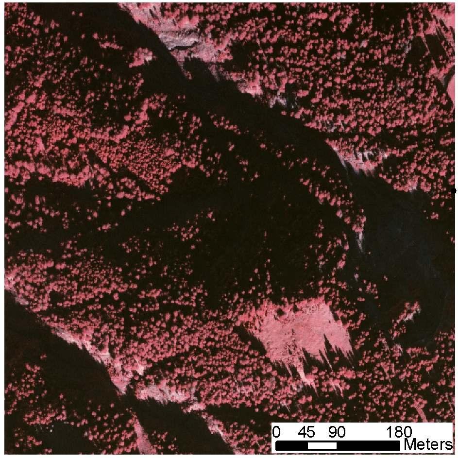
9 Canopy Height Model (CHM = DSM DTM) 9 / 37
 based on 3D-Laser Points E.g.")
10 Forest area mapping (I) Forest area mapping based on 3D-Laser Points E.g.: segmentation of the 3D-point cloud Classification of the derived segments High point density is required; time consuming computations! 10 / 37
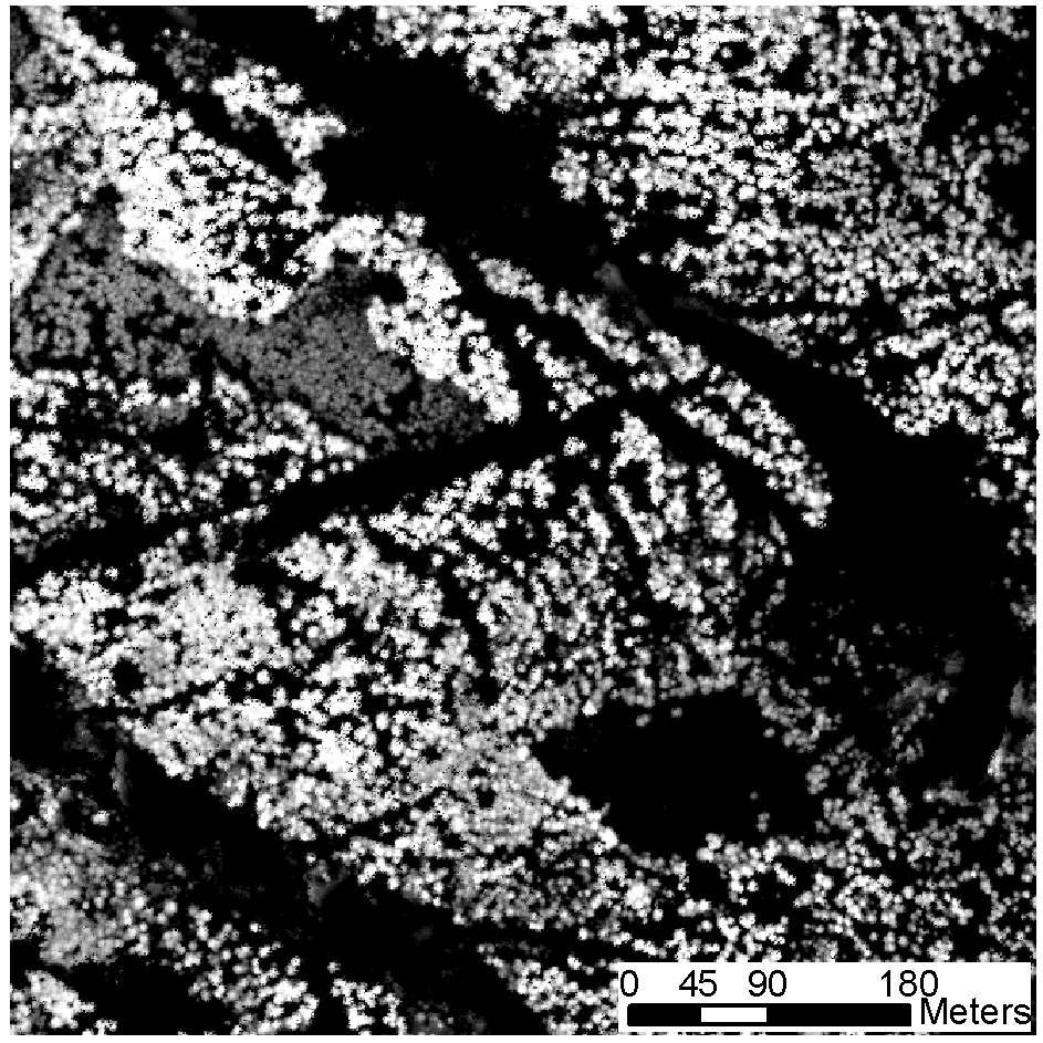
 Smoothing of forest borders (e.g. morphological operations) Object heights >25.0 m 0.0 m Buildings Forest (h > 1m) 11 / 37")
11 Forest area mapping (II) Pixel-based forest area mapping based on the ndsm E.g.: ndsm > 2M forest, buildings Removal of buildings (e.g. roofs smooth surface; forests rough surface) Removal of small forest areas (e.g. minimum mapping unit 50m²) Smoothing of forest borders (e.g. morphological operations) Object heights >25.0 m 0.0 m Buildings Forest (h > 1m) 11 / 37

 Object-based")


12 Forest area mapping (III) Object-based forest area mapping based on the ndsm Segmentation of the ndsm (e.g. watershed, region growing, ) Object-based classification of the derived segments Removal of small forest areas (e.g. minimum mapping unit 50m²) Smoothing of forest borders (e.g. morphological operations) Tree segments Buildings Forest 12 / 37
 Advances in Geosciences, 5, 57-63 13 / 37")
13 Forest area mapping (IV) Object-based land cover classification based on ALS (ndsm) and orthophotos (e.g. ecognition, ) CIR Orthophoto ALS Heights (ndsm) Classification Hollaus et al. (2005) Advances in Geosciences, 5, / 37
14 Forest parameter from ALS data Two approaches Single-tree-based Higher ALS point density is required (e.g. > 4 points/m² Sensitive regarding differences in the point density and the acquisition time Derivation of forest parameter without reference data possible Time consuming computations Commonly used for small study areas (e.g. urban vegetation, ) Area-based (plot-/stand-level) Reference data (e.g. national forest inventory data) are required to calibrate the empirical models More robust than single-tree-based approaches Already in use for operational applications 14 / 37
15 Forest parameters for single trees Detection of single trees Tree height estimation Tree height Estimation of tree crown diameter (Maier Crown & Hollaus ø 2006) Diameter at breast height (dbh) dbh Tree species 15 / 37


 16 /")
16 Local maxima filters tree tops Detection of single trees Tree crown segmentation tree crowns (Maier & Hollaus 2006) 16 / 37
 Subtract the terrain height from the highest first-echo point First-echo height tree height terrain height ID X[m] Y[m] tree height [m] 1-31304.97 202855.")

17 Tree heights Extracting tree heights based on First-echo 3D-points (or the DSM) and DTM Search the highest first-echo point inside a radius (depending on the tree height) Subtract the terrain height from the highest first-echo point First-echo height tree height terrain height ID X[m] Y[m] tree height [m] / 37


18 Practical problems for single-tree parameter estimations Interlocked trees 6 single trees are interlocked to 2 groups Dense forests If ALS data have a low point density single trees can hardly be detected Leaning trees An overestimation of the tree heights occurs (yellow line) 18 / 37
 Based on the tree-crown area (Hyyppä et al.")
19 Tree crowns Estimation of tree-crown diameters Calculation of the mean diameter of the derived tree-crown segments (e.g. mean diameter, smallest enclosing circle, ) Based on the tree-crown area (Hyyppä et al., 2001) Fitting rotating ellipsoids (Vögtle & Steinle, 2004) Fitting fourth order polynomial functions (Popescu et al., 2003) 19 / 37
20 Diameter at breast height / stem volume Assessment of diameters at breast height (1.3 m) dbh Based on empirical functions E.g.: dbh = f (tree height, crown diameter) ) E.g.: dbh = f (tree height, crown diameter, tree species) ) Stem volume Based on empirical functions E.g.: Stem volume = f (tree height, dbh, tree species) ) 20 / 37

21 Tree species For different tree species typical tree crown models can be found in the literature Fitting these models into the 3D-ALS point cloud best fit tree species Tree species classification based on the vertical distribution of the laser points 21 / 37


22 Application of single-tree specific parameters A digital model of the forest derived from ALS can be used for Forest management and planning activities Ecological studies Fire behavior modeling Basis for a urban tree cadastre Visualizations 22 / 37
23 Area-based forest parameters Crown cover / structure types Stand heights Stem volume Biomass 23 / 37

24 Crown cover / structure types (I) Segmentation of the ndsm derive areas with homogenous canopy heights Classification based on canopy heights (Maier B. et al. 2007) 24 / 37

25 Crown cover / structure types (II) Meta-segmentation forest stands Classification forest structure for each forest stand (Maier B. et al. 2007) 25 / 37

26 Crown cover / structure types (III) Mapping the forest structure types for large areas (Maier B. et al. 2007) 26 / 37

27 Based on the ndsm Forest stand heights The outline of the forest stands can be generated from the ALS data or can be taken from a GIS Mean heights, median height, 27 / 37
28 Lorey s mean height Lorey s mean height is the mean tree height weighted by the basal areas Basal area is the cross section area of a tree at breast height (1.3m above ground level). 50 Canopy heights [m] ALS points [%] ALS points [%] e.g. For the sample plot number 459 the canopy height at 88% corespondent to the Lorey s mean height 28 / 37
 of Austria is based on permanent, regularly distributed sample plots with a distance of 3.")
29 Stem volume estimation The estimation of stem volume is based on empirical models For the calibration of the models reference data are required E.g. national forest inventory data E.g. The National Forest Inventory (NFI) of Austria is based on permanent, regularly distributed sample plots with a distance of 3.89 km Each grid point (tract) consists of 4 Angle gauge sample plots 29 / 37

30 Example Vorarlberg: NFI data Entire district of Vorarlberg km² entire area 970 km² forest area Altitudes: m NFI data 132 Bitterlich plots Tree-based parameter Position, species, bhd, height Area-based parameter Stem volume [m³/ha] 30 / 37

31 Example Vorarlberg: ALS data Data acquisition within the framework of a commercial terrain mapping project Acquisition time: Higher altitudes in summer under snow free conditions Lower altitudes in autumn, winter, spring with leaf-off condition Point densities: 1-4 p/m² Flying heights: ~650 to 2000 m Different ALS sensors: Optech ALTM 1225 & 2050, Leica ALS50 Complex flight pattern due to the difficult topography Exact georeferencing is required The derived topographic models (DTM, DSM, CHM) have a spatial resolution of 1 m 31 / 37

![fi β i n Stem volume - forest inventory data [m³/ha] Unknown model parameters Number of](/docs-images/75/71794822/images/32-1.jpg "canopy height classes v can,i ch mean,i Canopy volumes for the canopy height classes i")
![[m³/ha] Mean canopy height for the canopy height classes i [m] f first-echo,i](/docs-images/75/71794822/images/32-2.jpg "Percentage of first echoes within the canopy height class i [-] V can calculated from")
32 Empirical stem volume model: concept Stem volume = f(canopy volume) v v stem, fi can, i = = f n i= 1 βi v first-echo, i can, i ch mean, i v stem.fi β i n Stem volume - forest inventory data [m³/ha] Unknown model parameters Number of canopy height classes v can,i ch mean,i Canopy volumes for the canopy height classes i [m³/ha] Mean canopy height for the canopy height classes i [m] f first-echo,i Percentage of first echoes within the canopy height class i [-] V can calculated from CHM of Ø20m around center NFI plot 32 / 37
33 Stem volume model calibration (I) Calibration of the stem volume model with NFI sample data The stem volume estimation is based on the 3D first echo laser points 33 / 37
34 Stem volume model calibration (II) Calibration of the stem volume model with NFI sample data The stem volume estimation is based on the ndsm (pixel size 1m) 34 / 37

35 Stem volume map Landesvermessungsamt Feldkirch & Stand Montafon Forstfonds 35 / 37


36 Validation Stand Montafon: ~500 sample plots ø 465 m³/ha ALS: ha Total: m³ ø 423 m³/ha ALS: ha Total: m³ ø 419 m³/ha 36 / 37
37 Application Stem volume map Outlines of forest stands Sample plots Holzvorrat pro Bestand Landesvermessungsamt Feldkirch & Stand Montafon Forstfonds 37 / 37
38 Summary and outlook Multiple-shift usage of ALS data Topographic models (DTM, DSM), buildings, power lines, parameters for vegetation, Competition between ALS data acquisition companies decreasing data costs quality!! Operational parameters from ALS Forest area mapping Single tree detection if the ALS point density is high enough (e.g. > 5 points/m² depending on the forest types / structure) Tree height estimation Stand heights, crown cover, Stem volume / biomass estimation for large areas Future work Transfer of the presented algorithms to deciduous forests Use of new laser scanner sensors e.g. Full-Waveform laser scanner data (amplitude, echo width, backscatter cross-section, ) 38 / 37
LiDAR based sampling for subtle change, developments, and status
 LiDAR based sampling for subtle change, developments, and status Erik Næsset Norwegian University of Life Sciences, Norway 2111 2005 Conclusions: 1. LiDAR is an extremely precise tool for measuring forest
Area-based parameterization of forest structure using full-waveform airborne laser scanning data
 Area-based parameterization of forest structure using full-waveform airborne laser scanning data Bernhard Höfle 1,2, Markus Hollaus 1,2, Hubert Lehner 1, Norbert Pfeifer 1 & Wolfgang Wagner 1,2 1 Institute
Airborne and Terrestrial Laser Scanning in Forestry
 Airborne and Terrestrial Laser Scanning in Forestry Géza Király 1, Gábor Brolly 1 1 University of West Hungary Faculty of Forestry Department of Surveying and Remote Sensing H-9400 SOPRON, Bajcsy-Zs u.
SAR forest canopy penetration depth as an indicator for forest health monitoring based on leaf area index (LAI)
") SAR forest canopy penetration depth as an indicator for forest health monitoring based on leaf area index (LAI) Svein Solberg 1, Dan Johan Weydahl 2, Erik Næsset 3 1 Norwegian Forest and Landscape Institute,
SAR forest canopy penetration depth as an indicator for forest health monitoring based on leaf area index (LAI) Svein Solberg 1, Dan Johan Weydahl 2, Erik Næsset 3 1 Norwegian Forest and Landscape Institute,
THE EFFECTS OF FOOTPRINT SIZE AND SAMPLING DENSITY IN AIRBORNE LASER SCANNING TO EXTRACT INDIVIDUAL TREES IN MOUNTAINOUS TERRAIN
 THE EFFECTS OF FOOTPRINT SIZE AND SAMPLING DENSITY IN AIRBORNE LASER SCANNING TO EXTRACT INDIVIDUAL TREES IN MOUNTAINOUS TERRAIN Y. Hirata Shikoku Research Center, Forestry and Forest Products Research
Very high resolution laser scanning point clouds from UAV for single tree analysis
 Very high resolution laser scanning point clouds from UAV for single tree analysis Norbert Pfeifer TU Wien Department of Geodesy and Geoinformation Contributions Gottfried Mandlburger Markus Hollaus Philipp
Operational low-cost treewise forest inventory using multispectral cameras mounted on drones
 Operational low-cost treewise forest inventory using multispectral cameras mounted on drones Dr. Eugene Lopatin, Natural Resources Institute Finland, eugene.lopatin@luke.fi, +358 29 532 3002 1 Key challenges/opportunities
Cross correlation of diameter measures for the co registration of forest inventory plots with airborne laser scanning data
 Cross correlation of diameter measures for the co registration of forest inventory plots with airborne laser scanning data J.M. Monnet, E. Mermin To cite this version: J.M. Monnet, E. Mermin. Cross correlation
Forest data services of the Finnish Forest Centre. Juho Heikkilä, Chief Forest Data Specialist, Lic.Sc. (For.) Lahti, Finland, May 31, 2017
 Lahti, Finland, May 31, 2017") Forest data services of the Finnish Forest Centre Juho Heikkilä, Chief Forest Data Specialist, Lic.Sc. (For.) Lahti, Finland, May 31, 2017 Finland - the most forested land in Europe The population of Finland
Forest data services of the Finnish Forest Centre Juho Heikkilä, Chief Forest Data Specialist, Lic.Sc. (For.) Lahti, Finland, May 31, 2017 Finland - the most forested land in Europe The population of Finland
ESTIMATION OF TREE SIZE DISTRIBUTIONS BY COMBINING VERTICAL AND HORIZONTAL DISTRIBUTION OF LASER MEASUREMENTS WITH EXTRACTION OF INDIVIDUAL TREES
 ESTIMATION OF TREE SIZE DISTRIBUTIONS BY COMBINING VERTICAL AND HORIZONTAL DISTRIBUTION OF LASER MEASUREMENTS WITH EXTRACTION OF INDIVIDUAL TREES Johan Holmgren and Jörgen Wallerman Swedish University
A preliminary evaluation of the application of multi-return LiDAR for forestry in Ireland
 Silviculture / Management No. 18 COFORD 2010 This study is a preliminary examination of the potential of LiDAR (Light Detection and Ranging) for forest resource assessment in Ireland. LiDAR allows the
VALIDATION OF HEIGHTS FROM INTERFEROMETRIC SAR AND LIDAR OVER THE TEMPERATE FOREST SITE NATIONALPARK BAYERISCHER WALD
 VALIDATION OF HEIGHTS FROM INTERFEROMETRIC SAR AND LIDAR OVER THE TEMPERATE FOREST SITE NATIONALPARK BAYERISCHER WALD T. Aulinger (1,3), T. Mette (1), K.P. Papathanassiou (1), I. Hajnsek (1), M. Heurich
New Features of Airborne Lidar Data Processing in DTM Generating, Forest Inventory and Civil Engineering Works
 New Features of Airborne Lidar Data Processing in DTM Generating, Forest Inventory and Civil Engineering Works Evgeny Medvedev, Altex Geomatica, Moscow, Russia Contents: About Altex Geomatica 12 years
A practical application of airborne LiDAR for forestry management in Scotland
 A practical application of airborne LiDAR for forestry management in Scotland Juan Suárez 1, Jacqueline Rosette 2, Bruce Nicoll 1 and Barry Gardiner 1 1 Forest Research Agency of the Forestry Commission,
ESTIMATION OF GROWTH RATES AT KIELDER FOREST USING AIRBORNE LASER SCANNING
 ESTIMATION OF GROWTH RATES AT KIELDER FOREST USING AIRBORNE LASER SCANNING A.S. Woodget*, D.M.N. Donoghue and P.E. Carbonneau. Department of Geography, University of Durham, Science Laboratories, South
AUTOMATIC DELINEATION OF FOREST STANDS FROM LIDAR DATA
 AUTOMATIC DELINEATION OF FOREST STANDS FROM LIDAR DATA V. J. Leppänen a, *, T. Tokola a, M. Maltamo a, L. Mehtätalo a, T. Pusa b, J. Mustonen c a University of Joensuu, Faculty of Forest Sciences PL111,
Exploiting fullwaveform lidar signals to estimate timber volume and above-ground biomass of individual trees
 Exploiting fullwaveform lidar signals to estimate timber volume and above-ground biomass of individual trees Tristan Allouis 1, Sylvie Durrieu 1 Cédric Véga 2 Pierre Couteron 3 1 Cemagref/AgroParisTech,
Applications and prospects of terrestrial LiDAR and drones for an improved forest inventory
 Applications and prospects of terrestrial LiDAR and drones for an improved forest inventory A review based on current literature Erich Seifert Stefan Seifert Anton Kunneke David M Drew Jan van Aardt Thomas
Terrestrial Laser Scanning in Forest Inventories
 ARTICLE TOWARD INTERNATIONAL BENCHMARKS Terrestrial Laser Scanning in Forest Inventories Measuring Tree Attributes Terrestrial laser scanning (TLS) is an effective technique for acquiring detailed tree
Airborne LiDAR Scanning for Forest Biomass Estimation
 Airborne LiDAR Scanning for Forest Biomass Estimation M. Balsi, S. Esposito, P. Fallavollita, C. Giannì DIET, La Sapienza University, Rome, Italy Oben srl, Sassari, Italy - www.oben.it marco.balsi@uniroma1.it
Precision forestry in Finland
 Precision forestry in Finland ICT Smart Precision Forestry with Laser Scanning, Finland Japan Joint Symposium (3 rd edition), Tokyo Associate Professor Mikko Vastaranta, School of Forest Sciences, Faculty
FOREST PARAMETER EXTRACTION USING TERRESTRIAL LASER SCANNING
 FOREST PARAMETER EXTRACTION USING TERRESTRIAL LASER SCANNING P.J.Watt *, D.N.M. Donoghue and R.W. Dunford Department of Geography, University of Durham, Durham, DH1 3LE, United Kingdom *Corresponding author:
Estimation of tree lists from airborne laser scanning data using a combination of analysis on single tree and raster cell level
 Estimation of tree lists from airborne laser scanning data using a combination of analysis on single tree and raster cell level Eva Lindberg 1, Johan Holmgren 1, Kenneth Olofsson 1, Håkan Olsson 1 and
Forest Assessments with LiDAR: from Research to Operational Programs
 Forest Assessments with LiDAR: from Research to Operational Programs David L. Evans Department of Forestry Forest and Wildlife Research Center Mississippi State University Forest Remote Sensing: Then and
LIDAR Forest Inventory With Single-Tree, Double- and Single-Phase Procedures
 LIDAR Forest Inventory With Single-Tree, Double- and Single-Phase Procedures Robert C. Parker 1 and David L. Evans Abstract. Light Detection and Ranging (LIDAR) data at 0.5- to -m postings were used with
Object-based approach for mapping complex forest structure phases using LiDAR data
 Object-based approach for mapping complex forest structure phases using LiDAR data M. Petr* a, M. Smith a, J.C. Suaréz b a Centre for Human and Ecological Sciences, Forest Research, Northern Research Station,
INVENTORY? - MEASUREMENTS & - BASIC STATISTICS ARE IMPORTANT FOR PRUDENT FOREST MANAGEMENT
 INVENTORY? - MEASUREMENTS & - BASIC STATISTICS ARE IMPORTANT FOR PRUDENT FOREST MANAGEMENT BY BALOZI AND JARNO Contents What is ArboLiDAR? Input data Sampling and field work Automatic stand segmentation
Forest Biomass Change Detection Using Lidar in the Pacific Northwest. Sabrina B. Turner Master of GIS Capstone Proposal May 10, 2016
 Forest Biomass Change Detection Using Lidar in the Pacific Northwest Sabrina B. Turner Master of GIS Capstone Proposal May 10, 2016 Outline Relevance of accurate biomass measurements Previous Studies Project
Epsilon Open Archive
 This is an author produced version of a paper published in International Archives of the Photogrammetry, Remote Sensing and Spatial Information Sciences, Volume XXXIX-B8, 2012XXII ISPRS Congress, 25 August
Large Area Forest Inventory And Management Using Remote Sensing Data Combining Single Tree and Stand Level in a 4D-GIS-System
 Large Area Forest Inventory And Management Using Remote Sensing Data Combining Single Tree and Stand Level in a 4D-GIS-System Juergen Rossmann, Michael Schluse, Arno Buecken and Martin Hoppen Institute
K&C Phase 4 Status report. Retrieval of forest biomass and biomass change with spaceborne SAR
 K&C Phase 4 Status report Retrieval of forest biomass and biomass change with spaceborne SAR Johan Fransson 1, Jonas Fridman 1, Ivan Huuva 1 Håkan Olsson 1, Henrik Persson 1, Jörgen Wallerman 1, Maurizio
LiDAR Data capture with sensor SPL100 in the Region of Navarra
 Víctor García, Tracasa LiDAR Data capture with sensor SPL100 in the Region of Navarra Workshop: Use of algorithms on big DEM s Tønsberg, 4 th April 2018 Company Presentation - Tracasa TRACASA is a public
Big Databases in forest planning and operations New national lidar campaign in Sweden
 Big Databases in forest planning and operations New national lidar campaign in Sweden NB-Nord workshop Erik Willén Process Manager Digitalization Main research partners: LUKE (FI) Metsäteho (FI) Skogforsk
Stability of LiDAR-derived raster canopy attributes with changing pulse repetition frequency
 Stability of LiDAR-derived raster canopy attributes with changing pulse repetition frequency Allyson Fox 1,2, Chris Hopkinson 2,1 Laura Chasmer 3 & Ashley Wile 2 1Acadia University, Wolfville, Nova Scotia,
The Use of GIS in Site-Specific Forest Management
 The Use of GIS in Site-Specific Forest Management Christian Brodbeck Biosystems Engineering, Auburn University John Fulton, Joey Shaw, Tim McDonald, and Donn Rodekohr Auburn University Value Map The Goal
Methodologies of tropical forest carbon monitoring: Development and state-of-the-art for REDD+
 Methodologies of tropical forest carbon monitoring: Development and state-of-the-art for REDD+ International Symposium on Southeast Asian Tropical Rain Forest Research related with Climate Change and Biodiversity,
ULS LiDAR supported analyses of laser beam penetration from different ALS systems into vegetation
 ULS LiDAR supported analyses of laser beam penetration from different ALS systems into vegetation M. Wieser a, M. Hollaus a, G. Mandlburger a, P. Glira a, N. Pfeifer a a TU WIEN, Department of Geodesy
Using Imagery and LiDAR for cost effective mapping and analysis for timber and biomass inventories
 Using Imagery and LiDAR for cost effective mapping and analysis for timber and biomass inventories Mark Meade: CTO Photo Science Mark Milligan: President LandMark Systems May 2011 Presentation Outline
Estimation of 12 Biomass Parameters and Interaction between the Trees Using Terrestrial Laser Scanner
 Estimation of 12 Biomass Parameters and Interaction between the Trees Using Terrestrial Laser Scanner Irwan GUMILAR, Hasanuddin Zaenal ABIDIN, Eko PRASETYO, Ekus KUSTIWA, Indonesia Keywords: Biomass, Crown,
Automatic detection of dominated vegetation under canopy using Airborne Laser Scanning data
 Automatic detection of dominated vegetation under canopy using Airborne Laser Scanning data Andrea Barilotti 1, Francesco Sepic 2 & Elena Abramo 2 1 Department of Georesources and Territory, University
Opportunities for LIDAR to characterize forest stand characteristics and biomass
 August 211 Centre for Geo-Information Thesis Report GIRS-211-16 Opportunities for LIDAR to characterize forest stand characteristics and biomass Jeroen M. de Jong 1 Opportunities for LIDAR to characterize
Urban Forest Inventory Using LiDAR & Hyperspectral Images
 Urban Forest Inventory Using LiDAR & Hyperspectral Images Larger existing trees provide 60-70 times the benefit of newly planted trees Highest priority in managing any urban forest is a complete tree inventory
Workshop on 3D Remote Sensing in Forestry - Programme
 Workshop on 3D Remote Sensing in Forestry - Programme 18:00 -. Get-together meeting (Restaurant Esterhazy Keller, Haarhof 1, 1010 Vienna) Monday, 13 th February 2006 08:00-09:00 Registration 09:00-09:30
Sampling and Mapping Forest Volume and Biomass Using Airborne LIDARs
 Sampling and Mapping Forest Volume and Biomass Using Airborne LIDARs Erik Næsset 1, Terje Gobakken 2, and Ross Nelson 3 Abstract. Since around 1995, extensive research efforts have been made in Scandinavia
Mapping Forest Canopy Height with MISR
 Mapping Forest Canopy Height with MISR We previously demonstrated a capability to obtain physically meaningful canopy structural parameters using data from MISR in a geometric-optical (GO) modeling framework.
Mapping Forest Canopy Height with MISR
 Mapping Forest Canopy Height with MISR We previously demonstrated a capability to obtain physically meaningful canopy structural parameters using data from MISR in a geometric-optical (GO) modeling framework.
DETERMINATION OF THE FOREST CANOPY COVER USING A LOW- COST COMMERCIAL DRONE IN A TURKEY OAK AND DURMAST OAK STAND IN THE ZARAND MOUNTAINS, ROMANIA
 DETERMINATION OF THE FOREST CANOPY COVER USING A LOW- COST COMMERCIAL DRONE IN A TURKEY OAK AND DURMAST OAK STAND IN THE ZARAND MOUNTAINS, ROMANIA 12 T. P. BANU 1, G. F. BORLEA 1, C. BANU 1 1 Banat s University
UTILIZING AIRBORNE LASER INTENSITY FOR TREE SPECIES CLASSIFICATION
 UTILIZING IRORNE LER INTENITY FOR TREE PECIE CLIFICTION H. O. Ørka, E. Næsset, O. M. ollandsås Dept. of Ecology and Natural Resource Management, Norwegian University of Life ciences, P.O. ox 5003, N-1432
EVALUATION OF FOREST MACHINERY GROUND MOBILITY USING ALS DATA
 EVALUATION OF FOREST MACHINERY GROUND MOBILITY USING ALS DATA Marco Pellegrini, Stefano Grigolato, Raffaele Cavalli marco.pellegrini@unipd.it TESAF Departement University of Padova IUFRO 3.06 Conference
Evaluation of forest function using GIS data generated by LiDAR data UC th July 2014 ASIA AIR SURVEY Katsumasa OONO
 Evaluation of forest function using GIS data generated by LiDAR data UC644 15 th July 2014 ASIA AIR SURVEY Katsumasa OONO Back Ground & purpose In Japan, the Regional Forest Plan is planed every five year.
Access to the published version may require journal subscription. Published with permission from: Taylor & Francis.
 This is an author produced version of a paper published in International Journal of Remote Sensing. This paper has been peer-reviewed and is proof-corrected, but does not include the journal pagination.
Comparison of individual tree counts from both airborne and terrestrial LiDAR systems analyzed individually and combined in a Web-LiDAR Environment
 Comparison of individual tree counts from both airborne and terrestrial LiDAR systems analyzed individually and combined in a Web-LiDAR Environment Bryan Keough 1, Carlos A. Silva 1, Andrew T. Hudak 2,
Mapping Scotland with PALSAR: An Assessment of the Importance of L-Band Polarimetry
 Mapping Scotland with PALSAR: An Assessment of the Importance of L-Band Polarimetry Shane R. Cloude, AEL Consultants,Scotland, UK E-mail : aelc@mac.com Web :http://web.mac.com/aelc Iain H Woodhouse (2),
ASSESSING THE STRUCTURE OF DEGRADED FOREST USING UAV
 ASSESSING THE STRUCTURE OF DEGRADED FOREST USING UAV STUDY CASE IN YUNGAS CLOUD FOREST, NORTH ARGENTINA Fernando Rossi 1, Andreas Fritz 2, Gero Becker 1, Barbara Koch 2 Albert-Ludwigs-Universität Freiburg
Estimating Leaf Bulk Density Distribution in a Tree Canopy Using Terrestrial LiDAR and a Straightforward Calibration Procedure
 Supplementary Information Estimating Leaf Bulk Density Distribution in a Tree Canopy Using Terrestrial LiDAR and a Straightforward Calibration Procedure Supplementary A. Inventory-Based Method to Estimate
Mapping Hemlocks to Estimate Potential Canopy Gaps Following Hemlock Woolly Adelgid Infestations in the Southern Appalachian Mountains
 Mapping Hemlocks to Estimate Potential Canopy Gaps Following Hemlock Woolly Adelgid Infestations in the Southern Appalachian Mountains Tuula Kantola, Maria Tchakerian, Päivi Lyytikäinen-Saarenmaa, Robert
Estimation of forest above-ground biomass rate using airborne LiDAR data
 Popov M., Semko I., Kozak I., 2014. Estimation of forest above-ground biomass rate using airborne LiDAR data. PEK, T. XXXVIII, 33-40. Estimation of forest above-ground biomass rate using airborne LiDAR
Predicting Forest Stand Height and Canopy Cover from LANDSAT and LIDAR data using decision trees
 Predicting Forest Stand Height and Canopy Cover from LANDSAT and LIDAR data using decision trees Sašo Džeroski 1, Andrej Kobler 2, Valentin Gjorgjioski 1, Panče Panov 1 1 Jožef Stefan Institute, Dept.
Terrestrial Laser Scanning: Can we see the wood for the trees. Kenneth Olofsson SLU
 Terrestrial Laser Scanning: Can we see the wood for the trees Kenneth Olofsson SLU Terrestrial laser scanning (TLS) A laser scanner placed in the area of interest scans 360º, resulting in a 3D point cloud
Estimation of Canopy Structure and Individual Trees from Laser Scanning Data
 Estimation of Canopy Structure and Individual Trees from Laser Scanning Data Eva Lindberg Faculty of Forest Sciences Department of Forest Resource Management Umeå Doctoral Thesis Swedish University of
Disruptive Technologies Threatening NMCA s Centralized Mapping
 Disruptive Technologies Threatening NMCA s Centralized Mapping Juha Hyyppä, Anttoni Jaakkola, Antero Kukko, Harri Kaartinen, Xiaowei Yu, FGI CoE-LaSR Tero Heinonen, ArcticRed/FGI CoE-LaSR Laserscanning.fi
North West Geography
 ISSN 1476-1580 North West Geography Volume 11, Number 1, 2011 North West Geography, Volume 11, 2011 7 Characterising phenological changes in North West forests using terrestrial laser scanning: some preliminary
A Benchmark of Lidar-Based Single Tree Detection Methods Using Heterogeneous Forest Data from the Alpine Space
 Forests 2015, 6, 1721-1747; doi:10.3390/f6051721 OPEN ACCESS forests ISSN 1999-4907 www.mdpi.com/journal/forests Article A Benchmark of Lidar-Based Single Tree Detection Methods Using Heterogeneous Forest
Airship-based LiDAR and multi-sensor forest monitoring
 Airship-based LiDAR and multi-sensor forest monitoring S. Esposito, P. Fallavollita, M. Balsi, R. Tognetti, M. Marchetti COST WORKSHOP Green Engineering Camp ( GEC) Plitvice Lakes National Park, Croatia
Seeing the Trees in the Forest: Using Lidar and Multispectral Data Fusion with Local Filtering and Variable Window Size for Estimating Tree Height
 Seeing the Trees in the Forest: Using Lidar and Multispectral Data Fusion with Local Filtering and Variable Window Size for Estimating Tree Height Sorin C. Popescu and Randolph H. Wynne Abstract The main
AIRBORNE LIDAR FOR ESTIMATING ABOVEGROUND BIOMASS IN DIPTEROCARP FORESTS OF MALAYSIA
 AIRBORNE LIDAR FOR ESTIMATING ABOVEGROUND BIOMASS IN DIPTEROCARP FORESTS OF MALAYSIA Hamdan O. 1, Nor Azura O. 2, Nurul Dasani A.D. 2, Mohd Azahari F. 1 and Abd Rahman K. 1 1 Forest Research Institute
REMOTE SENSING BASED FOREST MAP OF AUSTRIA AND DERIVED ENVIRONMENTAL INDICATORS
 REMOTE SENSING BASED FOREST MAP OF AUSTRIA AND DERIVED ENVIRONMENTAL INDICATORS Heinz GALLAUN a, Mathias SCHARDT a, Stefanie LINSER b a Joanneum Research, Wastiangasse 6, 8010 Graz, Austria, email: heinz.gallaun@joanneum.at
Why We Chose Aerial Imagery to Manage our Trees
 Monica Silva The City of Vaughan, Asset Management Specialist Why We Chose Aerial Imagery to Manage our Trees City of Vaughan Population: 325,000 Roads: 832km Land Area: 27,000 Ha Street Trees: ~160-180K
Pilot Project National Forest Inventory (NFI) in Suriname. Cayenne, April 2014
 in Suriname. Cayenne, April 2014") Pilot Project National Forest Inventory (NFI) in Suriname Cayenne, 28 29 April 2014 Timeline 2009: COP15; Meetings between Suriname and Austria. 2010: Technical meetings between SBB and Austria; Austrian
Pilot Project National Forest Inventory (NFI) in Suriname Cayenne, 28 29 April 2014 Timeline 2009: COP15; Meetings between Suriname and Austria. 2010: Technical meetings between SBB and Austria; Austrian
ESTIMATING FOREST CROWN FUEL VARIABLES USING LIDAR DATA
 ESTIMATING FOREST CROWN FUEL VARIABLES USING LIDAR DATA Hans-Erik Andersen Precision Forestry Cooperative University of Washington College of Forest Resources Seattle, WA 98195 hanserik@u.washington.edu
3D Modeling of Urban Tree Crown Volumes Using Multispectral LiDAR Data
 3D Modeling of Urban Tree Crown Volumes Using Multispectral LiDAR Data Jonathan LI, Xinqu CHEN, Canada, Pengdi HUANG and Cheng WANG, China Key words: Carbon Storage, Multispectral LiDAR data, Dendrometric
Forest Biodiversity in Sweden
 Forest Biodiversity in Sweden Sören Wulff Department of Forest Resource Management Tract distribution One year sample Design of Swedish NFI Department of Forest Resource Management, BioSoil program European
LiDAR enhanced Inventory
 To keep that good wood, you need to know what you have and where it is! LiDAR enhanced Inventory ABCFP AGM, Vancouver 24 January, 2011 Roger Whitehead Canadian Wood Fibre Centre Victoria, BC Outline Introduction
An international comparison of individual tree detection and extraction using airborne laser scanning
 Zurich Open Repository and Archive University of Zurich Main Library Strickhofstrasse 39 CH-8057 Zurich www.zora.uzh.ch Year: 2012 An international comparison of individual tree detection and extraction
Newfoundland Fibre Inventory Project Maximizing the value of forests through enhanced inventory of fibre attributes
 Newfoundland Fibre Inventory Project Maximizing the value of forests through enhanced inventory of fibre attributes Background CBPPL Atlantic Innovation Fund (AIF) Project maintain and increase the competitiveness
Mining for the Timber-Volume for a State-Wide Forest Information System. LIDAR Mapping Forum, February, 15th, 2017 Dr.-Ing.
 Mining for the Timber-Volume for a State-Wide Forest Information System LIDAR Mapping Forum, February, 15th, 2017 Dr.-Ing. Arno Buecken Sustainable Usage of the Forest Key Idea: Do not harvest more than
PREDICTING DIAMETER AT BREAST HEIGHT FROM TOTAL HEIGHT AND CROWN LENGTH
 PREDICTING DIAMETER AT BREAST HEIGHT FROM TOTAL HEIGHT AND CROWN LENGTH Quang V. Cao and Thomas J. Dean Abstract Tree diameter at breast height (d.b.h.) is often predicted from total height (model a) or
ESRI Scholarship 2009 Assessing the Influence of Trees on Building Insolation
 ESRI Scholarship 2009 Assessing the Influence of Trees on Building Insolation Thoreau Rory Tooke PhD Candidate rorytooke@gmail.com Background My educational foundation, grounded in Geography, has inspired
CANOPY structure plays an essential role in biophysical
 IEEE TRANSACTIONS ON GEOSCIENCE AND REMOTE SENSING, VOL. 54, NO. 9, SEPTEMBER 2016 5011 International Benchmarking of the Individual Tree Detection Methods for Modeling 3-D Canopy Structure for Silviculture
The Art of Timber Cruising Part II Fixed-Area Plots
 The Art of Timber Cruising Part II Fixed-Area Plots In this second article on timber cruising, we will be looking at a simple method of preparing a basic description of the forest compartments in your
MAP PRODUCTION FOR FOREST PLANTATION AREAS IN KOSOVO
 MAP PRODUCTION FOR FOREST PLANTATION AREAS IN KOSOVO Ymer Kuka Mag. Eng. Ymer Kuka University of Prishtina, Faculty of Civil Engineering, Architecture and Geodesy, Department of Geodesy Bregu i Diellit
Mapping Habitat for the Ivory Billed Woodpecker and the California Spotted Owl : A Multisensor Fusion Approach
 Mapping Habitat for the Ivory Billed Woodpecker and the California Spotted Owl : A Multisensor Fusion Approach A. Swatantran 1, R. Dubayah 1, M. Hofton 1, J. B. Blair 2, A. Keister 3 B. Uihlein 3, P. Hyde
Possibilities of airborne laser scanning data for forestry applications
 Possibilities of airborne laser scanning data for forestry applications Möglichkeiten von Airborne-Laserscanning-Daten für forstliche Anwendungen 1 Introduction During the last decade the technology of
Forestry applications using LiDAR
 Forestry applications using LiDAR Ariadna Just (1), Mariló Cabré (1), Antonio Magariños (1), Jordi Vayreda (2) (1) ICGC (2) CREAF 2 Soil orders in Catalonia Forest presence 15% 30% 41% 8% 6% 56% Forest
Classification of coppice stands and high forest stands using airborne laser scanning data
 Workshop Lidar applications in forest inventory and related statistical issues DIBAF, via San Camillo de Lellis, Viterbo, Italy 8 May 2013 Classification of coppice stands and high forest stands using
Predicting productivity using combinations of LiDAR, satellite imagery and environmental data
 Date: June Reference: GCFF TN - 007 Predicting productivity using combinations of LiDAR, satellite imagery and environmental data Author/s: Michael S. Watt, Jonathan P. Dash, Pete Watt, Santosh Bhandari
Estimation of Forest Variables using Airborne Laser Scanning. Johan Holmgren Department of Forest Resource Management and Geomatics Umeå
 Estimation of Forest Variables using Airborne Laser Scanning Johan Holmgren Department of Forest Resource Management and Geomatics Umeå Doctoral thesis Swedish University of Agricultural Sciences Umeå
Table of Contents. Page 1 of 15
 Table of Contents 1. Introduction... 3 2. Steps of Lidar Tree Crown Identification Accuracy Analysis... 4 2.1 Ground Truthing Field Work... 4 2.2 Lidar Tree Crown Identification Accuracy Analysis and Algorithm
ANALYSIS OF MULTITEMPORAL AERIAL IMAGES FOR FENYŐFŐ FOREST CHANGE DETECTION
 DOI: 10.21120/LE/10/2/4 Landscape & Environment 10 (2) 2016. 89-100 ANALYSIS OF MULTITEMPORAL AERIAL IMAGES FOR FENYŐFŐ FOREST CHANGE DETECTION SHUKHRAT SHOKIROV* 1 GÉZA KIRÁLY 1 1 Department of Surveying
Forestry Applications of LiDAR Data Funded by the Minnesota Environment and Natural Resources Trust Fund
 Conservation Applications of LiDAR Data Workshops funded by the Minnesota Environment and Natural Resources Trust Fund Conservation Applications of LiDAR Data Workshops funded by: Minnesota Environment
Estimating Forest Structure Parameters on Fort Lewis Military Reservation using Airborne Laser Scanner (LIDAR) Data
 Data") Estimating Forest Structure Parameters on Fort Lewis Military Reservation using Airborne Laser Scanner (LIDAR) Data HANS-ERIK ANDERSEN JEFFREY R. FOSTER STEPHEN E. REUTEBUCH Abstract Three-dimensional
Estimating Forest Structure Parameters on Fort Lewis Military Reservation using Airborne Laser Scanner (LIDAR) Data HANS-ERIK ANDERSEN JEFFREY R. FOSTER STEPHEN E. REUTEBUCH Abstract Three-dimensional
Prediction of Stem Attributes by Combining Airborne Laser Scanning and Measurements from Harvesters
 SILVA FENNICA Silva Fennica 46(2) research articles www.metla.fi/silvafennica ISSN 0037-5330 The Finnish Society of Forest Science The Finnish Forest Research Institute Prediction of Stem Attributes by
Forest Modelling
 10676 - Forest Modelling 10676 - Forest Modelling Satellite Data-based Modelling of Forest Eco-system Services of Forest Areas in China Prof. Xiaoli Zhang Department of Forestry Management Beijing Forestry
The Digital Forest. Geospatial Technologies in Urban Forest Management. Justin Morgenroth New Zealand School of Forestry University of Canterbury
 The Digital Forest Geospatial Technologies in Urban Forest Management Justin Morgenroth New Zealand School of Forestry University of Canterbury Why Measure a Tree? Determine annual growth Determine value
AREA-BASED SNOW DAMAGE CLASSIFICATION OF FOREST CANOPIES USING BI-TEMPORAL LIDAR DATA
 AREA-BASED SNOW DAMAGE CLASSIFICATION OF FOREST CANOPIES USING BI-TEMPORAL LIDAR DATA M. Vastaranta *, I., Korpela, A., Uotila, A. Hovi, M. Holopainen Department of Forest Sciences, University of Helsinki,
METHODS FOR ACQUISITION OF BIOMASS COMPARTMENTS
 Austro2007/FORMEC 07: Meeting the eeds of Tomorrows Forests ew Developments in Forest Engineering, October 7 11, 2007, Vienna and Heiligenkreuz Austria METHODS FOR ACQUISITIO OF BIOMASS COMPARTMETS Otto
Prediction of Canopy Heights over a Large Region Using Heterogeneous Lidar Datasets: Efficacy and Challenges
 Remote Sens. 2015, 7, 11036-11060; doi:10.3390/rs70911036 Article OPEN ACCESS remote sensing ISSN 2072-4292 www.mdpi.com/journal/remotesensing Prediction of Canopy Heights over a Large Region Using Heterogeneous
Estimating plot-level tree height and volume of Eucalyptus grandis plantations using small-footprint, discrete return lidar data
 Article Estimating plot-level tree height and volume of Eucalyptus grandis plantations using small-footprint, discrete return lidar data Progress in Physical Geography 34(4) 515 540 ª The Author(s) 2010
Development of Measurement System for Evaluating Forest Ecosystems: Measurement Method of Aboveground Biomass Growth by Using Airborne Laser Survey
 Phyton (Austria) Special issue: "APGC 2004" Vol. 45 Fasc. 4 (517M524) 1.10.2005 Development of Measurement System for Evaluating Forest Ecosystems: Measurement Method of Aboveground Biomass Growth by Using
8/21/13. Outline. Feasibility of measuring individual trees using remote sensing. Introduction. Introduction -definition -usage -limitation
 Feasibility of measuring individual trees using remote sensing Mega Binti Abang PhD Candidate University of Tennessee Department of Forestry, Wildlife and Fisheries Room 160 Plant Biotech Building Wednesday