LiDAR Product Suite for the Hearst Forest
|
|
|
- Amberlynn Walsh
- 6 years ago
- Views:
Transcription


1 LiDAR Product Suite for the Hearst Forest & other R&D activities present and future Murray Woods Ontario Ministry of Natural Resources Doug Pitt Canadian Wood Fibre Centre


2 Advanced Forest Resource Inventory Technologies


3 TEAM AFRIT Doug Pitt Dave Nesbitt Margaret Penner Forest Analysis Ltd. Kevin Lim Lim Geomatics Paul Treitz Dave Etheridge Jeff Dech Don Leckie François Gougeon

4 National CWFC Program Regional Focus: AFRIT-Hearst

5 Outline LiDAR 101 LiDAR Derived Inventory Current LiDAR Inventory Products Other Hearst R&D efforts Looking forward
6 LiDAR Light Detection And Ranging Discrete System Active remote sensing technology; transmit & receive ~35, ,000 pulses of NIR laser light per second GPS provides the exact X-Y-Z position of each return Discrete System - Each pulse can produce multiple returns (3-5) Full Waveform System not limited to number of returns but detectible signals Used with permission of Doug Pitt
7 LiDAR Light Detection And Ranging Discrete System Active remote sensing technology; transmit & receive ~35, ,000 pulses of NIR laser light per second GPS provides the exact X-Y-Z position of each return Discrete System - Each pulse can produce multiple returns (3-5) Full Waveform System not limited to number of returns but detectible signals 2007 LiDAR
 Full Waveform System not limited to number of returns but detectible signals Source: e-education.psu.")
8 LiDAR Light Detection And Ranging Full Waveform System Active remote sensing technology; transmit & receive ~35, ,000 pulses of NIR laser light per second GPS provides the exact X-Y-Z position of each return Discrete System - Each pulse can produce multiple returns (3-5) Full Waveform System not limited to number of returns but detectible signals Source: e-education.psu.edu
9 LiDAR Light Detection And Ranging Full Waveform System (~48 rts/m 2 ) Active remote sensing technology; transmit & receive ~35, ,000 pulses of NIR laser light per second GPS provides the exact X-Y-Z position of each return Discrete System - Each pulse can produce multiple returns (3-5) Full Waveform System not limited to number of returns but detectible signals 2012 LiDAR

 Full Waveform System not limited to number of returns but detectible signals 2007 LiDAR")
10 LiDAR Light Detection And Ranging Discrete System (~3 rts/m 2 ) Full Waveform System (~48 rts/m 2 ) Active remote sensing technology; transmit & receive ~35, ,000 pulses of NIR laser light per second GPS provides the exact X-Y-Z position of each return Discrete System - Each pulse can produce multiple returns (3-5) Full Waveform System not limited to number of returns but detectible signals 2007 LiDAR 2012 LiDAR
11 LiDAR Light Detection And Ranging DSM DEM Imagery 11 3

12 LiDAR Light Detection And Ranging DSM DEM CHM Imagery 12 3


13 LiDAR Light Detection And Ranging Historical Reason for Acquiring LiDAR Data OBM 20m LiDAR 1m Classified Ground Returns Prince Edward County, Ontario

14 LiDAR Technology Classified non-ground Returns Classified Ground Returns Prince Edward County, Ontario

15 Operational Cruising Field Sampling Cruising generally not occurring in Boreal forests Very light 1%-2% Expensive only provides information on sampled sites extrapolated Need to do for the next stand and the next

16 LiDAR Derived Inventory Field Sampling vs. 100% Enumeration 100% enumeration of the landbase with LiDAR measurements of vertical structure Scalability permits the use of regression estimators to scale PU estimates to groups of PUs, Stand, Block or Forest
 Sampled 8 Forest Types x")

17 LiDAR Derived Forest Inventory - Approach 2010 Field Program Established 446 Calibration 400m 2 plots 64 Validation plots (2012) Sampled 8 Forest Types x Development stages LC SB SF SP PJ IH MWC - MWH All trees measured for DBH and height sample > 10 cm Trees <10 cm density count by 1 m height classes avg DBH Ecosite description
 vegetation")
18 LiDAR Derived Forest Inventory - Approach Additional forest inventory information contained in point cloud data Focus of AFRIT is Area based modeling NOT Individual Tree Prediction Unit = 20m X 20m (400m 2 ) vegetation ground
19 LiDAR Derived Forest Inventory - Approach Additional forest inventory information contained in point cloud data Focus of AFRIT is Area based modeling NOT Individual Tree Prediction Unit = 20m X 20m (400m 2 )


20 LiDAR Derived Inventory Pairing with Ground Data Field Plot Measurement


21 Enhanced Modeling Approaches - Simplified Regression randomforest y = b o + b 1 x 1 + b 2 x 2 Option for hundreds to thousands of trees
 40 30 20 10 0 LC MWC MWH PJ IH SB SF SP All Forest")
22 Comparison of Basal Area Predictions from RF and SUR Hearst Forest Observed RF SUR_FU 50 Basal Area (m 2 /ha) LC MWC MWH PJ IH SB SF SP All Forest Type


23 Enhanced Modeling Approaches Regression RandomForest Requires an existing polygon inventory Requires separate forest-type models to statistically be built - specialist Can t adjust to within polygon species variation Can extrapolate beyond model building data doesn't rely on an existing polygon inventory no separate forest-type models to statistically build very quick to implement custom application of LiDAR predictions for each 20m x 20m Predictions are equivalent to Regression
24 LiDAR Derived Inventory LiDAR predictive Models for: Height (AVG, Top) DBHq (~avgdbh) Volume (GTV, GMV) Basal area Biomass Density* Sawlog Volume Close Utilization Volume Dom/Codom Ht Mean Tree GMV Size Class Distributions Predicted LiDAR - SUR * Derived from DBHq & BA Observed All Data

25

26
27
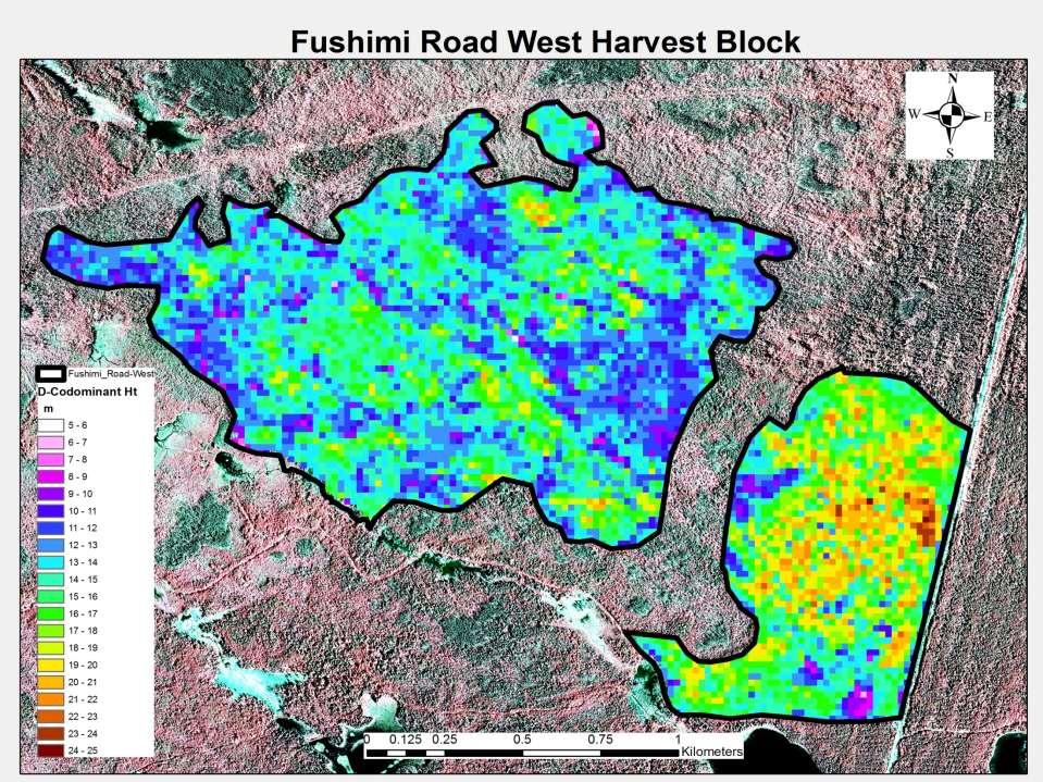
28 Dominant/Codominant Ht
29 DBHq
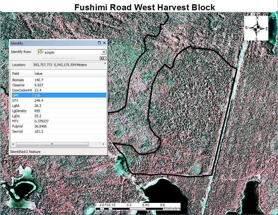
30 Gross Merchantable Volume

31 Gross Merchantable Volume m 3 /ha
 154.")

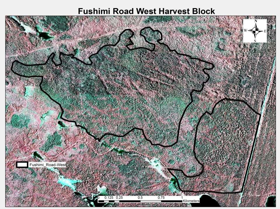
32 Block Summary 186 ha a) 97.5 m 3 /ha * 186 ha = 18,135.0 m 3 75 ha b) m 3 /ha * 75 ha = 11,587.5 m m 3 /ha * 261 ha = 29,701.8 m 3 Minimum: 0.75 m 3 /ha Maximum: m 3 /ha


33 Optimistic Sawlog Volume Mean Tree Volume Derived Pulp Volume Merchantable Basal Area


34 Hearst LiDAR Derived Size-Class Distributions Black Spruce Validation Data by VCI class Size Class Distributions from Airborne LiDAR for a Boreal Forest. Woods et al 2013 In Prep. Van Ewijk, K.Y, P.M. Treitz and N. A. Scott Characterizing forest succession in central Ontario using Lidar-derived indices. Photogrammetric Engineering and Remote Sensing 77:
35 i

36
37
38

39

40 Gross Merchantable Volume


41 LiDAR Derived Inventory RMF Block Validation Pj Clearcuts: ~within 2-5% Po Clearcuts: ~ within 5 15% Sb with retention: ~5-25% net down for cull Retention has to be factored in Image and data courtesy Tembec Inc.
42 Approach Volume Comparison LiDAR provides better volume prediction (statistically tested) Yield Curve Yield Curve: 14.5% LIDAR: 5.4 % BW SP PJ PO % 10% 0% -22% % 33% 3% -34% % -15% 0% 1% 244-9% 34% -12% -14% 245-2% 9% -1% -6% 246-2% 20% -1% -17% 251 6% 33% 6% -45% 252 9% 55% 1% -66% 254-1% 4% 10% -12% 256 1% -6% 5% 257 7% -17% 9% 259 1% 0% -1% 275 Difference from harvested volume (scaled) LIDAR BW SP PJ PO 208 2% -6% 0% 3% % 6% 1% 8% 220 0% -11% 4% 7% % 2% 2% 5% 245 0% 5% 1% -6% 246 0% 5% 1% -6% 251 1% 11% 5% -17% 252 4% 23% 2% -29% 254 1% -4% 0% 4% 256 2% -1% -1% 257 2% -5% 3% 259-3% -2% 5% % & under greater than 10 %
43 Hearst Forest ITC Individual Tree Classification


44 Hearst Forest ITC Individual Tree Classification
45 Hearst Forest ITC Individual Tree Classification ~150,000 ha operationally classified with ITC 730 stands Range of Forest Types Range of Height Classes 2 Certified Forest Interpreters vs. Computer ITC Software Misclassification type Leading Species Comparison Interpreter 1 vs. 2 Interpreter vs. ITC Agreement 59% 39% Close (similar species e.g., Sw, Sb) 71% 51% Within hardwood or softwood 91% 81% Serious disagreement 9% 19%
46 Hearst Forest ITC Individual Tree Classification Interpreter 1 Interpreter 2 % Ab Bf Bw Cw La Pb Pj Pt Sb Sw agreement Ab 0% * Not significantly different Bf % Bw % Cw % La % Pb % Pj 0% Pt % Sb % Sw % Total % Interpreter ITC % Ab Bf Bw Cw La Pb Pj Pt Sb Sw agreement Interp 1 vs. Interp 2: % Agreement for NE SFU - 55% Ab 2 1 0% Bf % Bw % Cw % La % Pb % Pj 1 1 0% Pt % Sb % Sw % Total %
47 Photo interpreter height (m) Photo Interpreter 2 height (m) Hearst Forest ITC Individual Tree Classification Height a) * Not significantly different OHT_2 10 1:1 line Photo Interpreter 1 height (m) b) * Significantly different for a reason OHT_2 1:1 line OHT_ ITC height (m)
48 Photo interpreter height (m) Photo Interpreter 2 height (m) Hearst Forest ITC Individual Tree Classification Crown Closure a) * Significantly different OHT_2 10 1:1 line b) Photo Interpreter 1 height (m) * Significantly different OHT_2 1:1 line OHT_ ITC height (m)

49 Ongoing Enhancements Low Density LiDAR based Species Group Classification Predicted (%) Actual HWD MWC MWH CONIFER HWD MWC 100 MWH CONIFER 4 96 N = 346 plots; 86 used for validation Woods et al. (in prep)

50 Ongoing Enhancements LiDAR Species Classification from Low to High Density Error matrix of classification Baoxin Hu Dept. of Earth and Space Science and Engineering York University, Toronto, Canada
 Environmental input variables: Elevation (10m) Slope (%)")
 (medium window =")
51 Ongoing Enhancements (Akumu et al. In Prep) Environmental input variables: Elevation (10m) Slope (%) Surface shape (Curvature) Mode of deposition (NOEGTS) Landcover Slope Position from TPI (macro window = 1km) (medium window = 500m) (micro window = 20m) Wetness Index

52 Ongoing Enhancements Wet Areas Mapping Site Productivity Linkage - Ecosite
53 Ongoing Enhancements WAM Mapping Site Productivity - Ecosite

54 Ongoing Enhancements WAM Mapping Site Productivity - Ecosite

55 Ongoing Enhancements Fibre Analysis Jeff Dech, Bharat Pokharel, Art Groot Sampling on AFRIT- Hearst Plot Network


56 Looking Forward Semi Global Matching - Pixel Correlation Not the same as LiDAR but similar Image based product Very detailed DSM Lower cost acquisition produced with each inventory period LiDAR SGM

57 Study on the Hearst Forest to: Average stem characteristics 100 Develop process to utilize SGM point cloud like LiDAR Observed LiDAR-predicted SGM-predicted with LiDAR DEM m 3 /100 Compare potential SGM predictions with those derived from LiDAR m m cm 0 Used the LiDAR derived Hearst DEM to normalize SGM data Top Height D-C Height QM-DBH AGMV Stand characteristics m 2 /ha m 3 /ha x 10 m 3 /ha x stems/ha x A comparison of airborne LiDAR and digital photogrammetric point clouds for the areabased estimation of forest inventory attributes in boreal Ontario Doug G. Pitt, Murray Woods, and Margaret Penner (Submitted for review November 2013) BA GMV SLV Density
58 Top height (m) LiDAR SGM-LiDAR_DEM Stem Characteristics D-C height (m) QM-DBH (cm) RMSE = 1.21 m RMSE = 1.69 m RMSE = 2.11 cm RMSE = 1.54 m RMSE = 1.92 m RMSE = 2.57 cm Forest Type SB (34%) SP (25%) SF (5%) PJ (3%) LC (3%) MWC (18%) MWH (7%) PO (5%) image-based point clouds were found produce accuracies that were equivalent to LiDAR, however some losses in precision were evident (Pitt et al in review) AGMV (m 3 ) RMSE = 0.05 m RMSE = 0.06 m
59 BA (m 2 /ha) LiDAR SGM-LiDAR_DEM Stand Characteristics GMV (m 3 /ha) SLV (m 3 /ha) RMSE = 7.47 m 2 /ha RMSE = 38.7 m 3 /ha RMSE = 8.00 m 2 /ha RMSE = 38.4 m 3 /ha + Forest Type SB (34%) SP (25%) SF (5%) PJ (3%) LC (3%) For variables such as basal area, gross merchantable volume and sawlog volume, such losses in precision amounted to less than 10% increases in mean absolute errors RMSE = 35.0 m 3 /ha RMSE = 36.0 m 3 /ha MWC (18%) MWH (7%) PO (5%) (Pitt et al in review) Density (stems/ha) RMSE = 421 stems/ha RMSE = 468 stems/ha
60 SGM Predictions Normalized on OBM 20m DEM Increased loss of precision from process using LiDAR DEM May still be an enhancement CAUTION Study area was relatively flat Top height (m) D-C height (m) QM-DBH (cm) AGMV (m 3 ) RMSE = 1.82 m RMSE = 1.82 m RMSE = 2.98 cm BA (m 2 /ha) GMV (m 3 /ha) SLV (m 3 /ha) Density stems/ha RMSE = 7.99 m 2 /ha RMSE = 46.3 m 3 /ha RMSE = 43.5 m 3 /ha Forest Type SB (34%) SP (25%) SF (5%) PJ (3%) LC (3%) MWC (18%) MWH (7%) PO (5%) (Pitt et al in review) 0.1 RMSE = 0.07 m RMSE = 506 stems/ha


61 FPInnovations Advantage Report 14(1), 2013, Pointe-Claire, QC, 8 p.

62 Objectives Are LiDAR-enhanced inventories leading to better forest management decisions? What are the cost savings associated with enhanced decision making?
63 Approach Volume Comparison LiDAR provides better volume prediction (statistically tested) Yield Curve Yield Curve: 14.5% LIDAR: 5.4 % BW SP PJ PO % 10% 0% -22% % 33% 3% -34% % -15% 0% 1% 244-9% 34% -12% -14% 245-2% 9% -1% -6% 246-2% 20% -1% -17% 251 6% 33% 6% -45% 252 9% 55% 1% -66% 254-1% 4% 10% -12% 256 1% -6% 5% 257 7% -17% 9% 259 1% 0% -1% 275 Difference from harvested volume (scaled) LIDAR BW SP PJ PO 208 2% -6% 0% 3% % 6% 1% 8% 220 0% -11% 4% 7% % 2% 2% 5% 245 0% 5% 1% -6% 246 0% 5% 1% -6% 251 1% 11% 5% -17% 252 4% 23% 2% -29% 254 1% -4% 0% 4% 256 2% -1% -1% 257 2% -5% 3% 259-3% -2% 5% % & under greater than 10 %

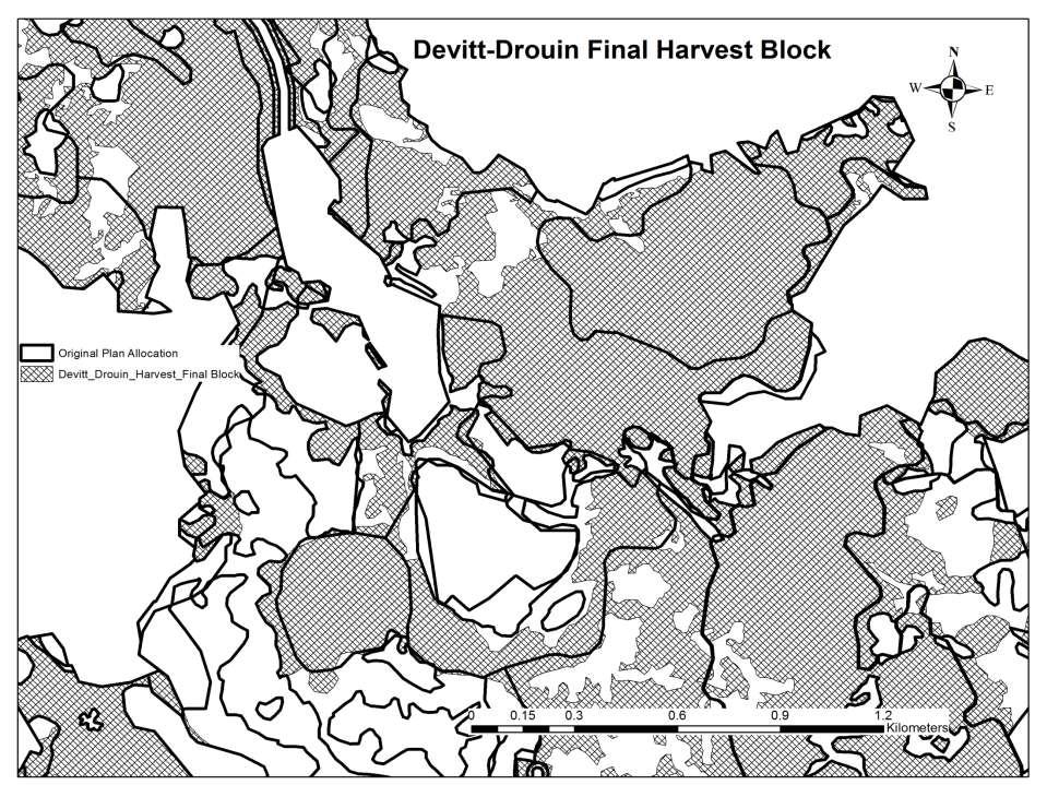
64 Approach Cost Analysis Comparison of 2 scenarios 1. Actual cut over ACTUAL Area harvested within approved plan 2. Redesign blocks within proposed plan LIDAR New harvest planning using LiDAR for area similar to initial plan Validated by Tembec FRM Stay within approved 5 year harvest blocks


 ACTUAL GMV")
65 Approach Cost Analysis: Scenarios Redesign plan, based on full suite of LiDAR data products Removed area of less GMV from Scenario DBHq (cm) ACTUAL GMV (m 3 ha) LIDAR


66 Approach Cost Analysis Categories Three groups of cost items : A. Inventory acquisition and processing - 6 items B. Forest operations 20 items C. Mill - 4 items


67 Results: Actual vs. LiDAR Scenario Three groups of cost items : A. Inventory acquisition and processing - 6 items B. Forest operations 20 items C. Mill - 4 items $ m 3 $ 1.40 m 3 $ 0.30 m 3 Savings $ 1.60 m 3 X 500,000 m 3 / year = $ 800,000 / year Payback = 1.3 years *Tembec s LiDAR acquisition 50% of what was modeled so payback was achieved in the first year!!!


, 2013, Pointe- Claire, QC, 8 p.")
68 July/Aug Vol 86. No 4 Forestry Chronicle Remote Sens. 2013, 5, ; doi /rs FPInnovations Advantage Report 14(1), 2013, Pointe- Claire, QC, 8 p. Contact information: murray.woods@ontario.ca dpitt@nrcan.gc.ca
Airborne LiDAR for EFI : what s operational ; what s R&D today
 Airborne LiDAR for EFI : what s operational ; what s R&D today For. Chron.: 87: 512-528 SL212-33 SL212-14 SL212-29 Doug Pitt Woodlands Forum, Moncton, NB Apr. 2-4, 213 height LiDAR 11 Using the point clouds
LiDAR enhanced Inventory
 To keep that good wood, you need to know what you have and where it is! LiDAR enhanced Inventory ABCFP AGM, Vancouver 24 January, 2011 Roger Whitehead Canadian Wood Fibre Centre Victoria, BC Outline Introduction
Airborne LiDAR for EFI in the boreal: what s operational ; what s R&D today
 Airborne LiDAR for EFI in the boreal: what s operational ; what s R&D today For. Chron.: 87: 512-528 SL212-33 SL212-14 SL212-29 Doug Pitt CIF-Manitoba Section Enhanced Forest Inventory Jan. 23, 213, Winnipeg,
Exploration of the innovation potential of single-photon LiDAR for Ontario s efri
 Exploration of the innovation potential of single-photon LiDAR for Ontario s efri GMV Dbhq Murray Woods Canadian Wood Fibre Centre Ian Sinclair Ontario Ministry of Natural Resources and Forestry Outline
The effects of precommercial thinning on the value chain of balsam fir spruce stands in northwestern New Brunswick, Canada.
 The effects of precommercial thinning on the value chain of balsam fir spruce stands in northwestern New Brunswick, Canada. Doug Pitt, Len Lanteigne, and collaborators CIF-IFC Electronic Lecture, September
Enhanced Forest Inventory A case study in the Alberta foothills
 SISCO Southern Interior Silviculture Committee Enhanced Forest Inventory A case study in the Alberta foothills Roger Whitehead & Jim Stewart CFS, Canadian Wood Fibre Centre Glenn Buckmaster West Fraser
Enhanced Forest Inventory A case study in the Alberta foothills
 Enhanced Forest Inventory A case study in the Alberta foothills Roger Whitehead & Jim Stewart CFS, Canadian Wood Fibre Centre Glenn Buckmaster West Fraser Mills, Hinton Wood Products Mike Wulder, Joanne
Benchmark Yield Curves. Scott McPherson OMNR Margaret Penner - Forest Analysis Ltd.
 Benchmark Yield Curves Scott McPherson OMNR Margaret Penner - Forest Analysis Ltd. Objective of Presentation Context: past, present Review of PR1 results Present results on validation Current yield curve
Forest Inventory in New Brunswick: A Year with LiDAR. Adam Dick New Brunswick Department of Natural Resources NEMO/SOMENS November 2014
 Forest Inventory in New Brunswick: A Year with LiDAR Adam Dick New Brunswick Department of Natural Resources NEMO/SOMENS November 2014 New Brunswick 750,000 people 7.3 million hectares 83% forested 9.5
The Use of Terrestrial LiDAR to Characterize Single Trees Jean-François Côté (CWFC) Chhun-Huor Ung (CWFC) Joan Luther (CFS)
 Chhun-Huor Ung (CWFC) Joan Luther (CFS)") The Use of Terrestrial LiDAR to Characterize Single Trees Jean-François Côté (CWFC) Chhun-Huor Ung (CWFC) Joan Luther (CFS) Canadian Woodlands Forum 2013 Fall Meeting Inventory Inventory information essential
The Use of Terrestrial LiDAR to Characterize Single Trees Jean-François Côté (CWFC) Chhun-Huor Ung (CWFC) Joan Luther (CFS) Canadian Woodlands Forum 2013 Fall Meeting Inventory Inventory information essential
Using Imagery and LiDAR for cost effective mapping and analysis for timber and biomass inventories
 Using Imagery and LiDAR for cost effective mapping and analysis for timber and biomass inventories Mark Meade: CTO Photo Science Mark Milligan: President LandMark Systems May 2011 Presentation Outline
Application of remote sensing by the New Zealand forest industry. Aaron Gunn
 Application of remote sensing by the New Zealand forest industry Aaron Gunn Presentation Overview History LiDAR Cluster Group Personal Experience - Blakely Pacific Ltd (silvicultural scheduling) Remote
Newfoundland Fibre Inventory Project Maximizing the value of forests through enhanced inventory of fibre attributes
 Newfoundland Fibre Inventory Project Maximizing the value of forests through enhanced inventory of fibre attributes Background CBPPL Atlantic Innovation Fund (AIF) Project maintain and increase the competitiveness
Petawawa Research Forest Using 100 Years of Research to Combat Climate Change!
 Petawawa Research Forest Using 100 Years of Research to Combat Climate Change! Guy Smith TDT Manager - CWFC Canadian Wood Fibre Centre 1 Talk-show Participants Guy Smith TDT Manager - CWFC Steve D Eon
Forest Assessments with LiDAR: from Research to Operational Programs
 Forest Assessments with LiDAR: from Research to Operational Programs David L. Evans Department of Forestry Forest and Wildlife Research Center Mississippi State University Forest Remote Sensing: Then and
Incorporating multi-cohort old aspen and mixedwood dynamics into a long term forest management plan
 Incorporating multi-cohort old aspen and mixedwood dynamics into a long term forest management plan Session 4a Beyond Breakup Boreal Mixedwoods 2012 Conference Edmonton, AB Paul LeBlanc June 19 th, 2012
Refinement of the FVS-NE predictions of
 Refinement of the FVS-NE predictions of individual tree growth response to thinning PI: Aaron Weiskittel University of Maine, School of Forest Resources Co-PIs: John Kershaw University of New Brunswick
Mixedwood management for the late 21 st century what might the future hold?
 Mixedwood management for the late 21 st century what might the future hold? Phil Comeau University of Alberta, Edmonton, Canada Phil.Comeau@ales.ualberta.ca Boreal Mixedwood Stands in 2062 Heterogeneity
Forest data services of the Finnish Forest Centre. Juho Heikkilä, Chief Forest Data Specialist, Lic.Sc. (For.) Lahti, Finland, May 31, 2017
 Lahti, Finland, May 31, 2017") Forest data services of the Finnish Forest Centre Juho Heikkilä, Chief Forest Data Specialist, Lic.Sc. (For.) Lahti, Finland, May 31, 2017 Finland - the most forested land in Europe The population of Finland
Forest data services of the Finnish Forest Centre Juho Heikkilä, Chief Forest Data Specialist, Lic.Sc. (For.) Lahti, Finland, May 31, 2017 Finland - the most forested land in Europe The population of Finland
Forestry Applications of LiDAR Data Funded by the Minnesota Environment and Natural Resources Trust Fund
 Conservation Applications of LiDAR Data Workshops funded by the Minnesota Environment and Natural Resources Trust Fund Conservation Applications of LiDAR Data Workshops funded by: Minnesota Environment
USING LIDAR AND RAPIDEYE TO PROVIDE
 USING LIDAR AND RAPIDEYE TO PROVIDE ENHANCED AREA AND YIELD DESCRIPTIONS FOR NEW ZEALAND SMALL-SCALE PLANTATIONS Cong (Vega) Xu Dr. Bruce Manley Dr. Justin Morgenroth School of Forestry, University of
Applications and prospects of terrestrial LiDAR and drones for an improved forest inventory
 Applications and prospects of terrestrial LiDAR and drones for an improved forest inventory A review based on current literature Erich Seifert Stefan Seifert Anton Kunneke David M Drew Jan van Aardt Thomas
Quality and Value-based Hardwood Forest Management
 Quality and Value-based Hardwood Forest Management D. Edwin Swift, R.P.F., CF Natural Resources Canada, Canadian Wood Fibre Centre Edwin.Swift@NRCan-RNCan.gc.ca 506-452-3175 Hardwood Research Initiative
Application of airborne LiDAR in forestry in North America and Scandinavia. ForestrySA LiDAR initiatives
 Application of airborne LiDAR in forestry in North America and Scandinavia ForestrySA LiDAR initiatives Jan Rombouts Airborne LiDAR is a great data source for forestry Transect through LiDAR data set,
Simulating UAV sampling using high-density Lidar data to characterize the structure of short canopies
 Simulating UAV sampling using high-density Lidar data to characterize the structure of short canopies IAPP Project nr. 286079 Aircraft for Environmental and Forest Science AIRFORS Loris Vescovo, Chiara
A guide to translate central Ontario ecosites into Ecosites of Ontario
 Ministry of Natural Resources Ecological Land Classification Central Ontario A guide to translate central Ontario ecosites into Ecosites of Ontario Monique Wester, Peter Uhlig, Erin Banton and Rachelle
Goal of project Importance of work Software and processes Methods Results and discussion Strengths and limitations Conclusions 3/11/2010
 Presented by Joey Roberts and James Bradd Goal of project Importance of work Software and processes Methods Results and discussion Strengths and limitations Conclusions 1 Test hypothesis that the distribution
A preliminary evaluation of the application of multi-return LiDAR for forestry in Ireland
 Silviculture / Management No. 18 COFORD 2010 This study is a preliminary examination of the potential of LiDAR (Light Detection and Ranging) for forest resource assessment in Ireland. LiDAR allows the
Mule Deer Winter Range Planning. Current And Future Forest Condition Pilot Project. Submitted to:
 Mule Deer Winter Range Planning Current And Future Forest Condition Pilot Project Submitted to: Ministry of Sustainable Resource Management Cariboo Region March, 2003 FIRS Project # 1029-16 Professional
Airborne Laser Scanning (ALS) for forestry applications
 for forestry applications") Airborne Laser Scanning (ALS) for forestry applications International School on Lidar Technology 2008 IIT Kanpur, India Norbert Pfeifer + I.P.F.-Team http://www.ipf.tuwien.ac.at/ Christian Doppler Laboratory
Airborne Laser Scanning (ALS) for forestry applications International School on Lidar Technology 2008 IIT Kanpur, India Norbert Pfeifer + I.P.F.-Team http://www.ipf.tuwien.ac.at/ Christian Doppler Laboratory
The Digital Forest. Geospatial Technologies in Urban Forest Management. Justin Morgenroth New Zealand School of Forestry University of Canterbury
 The Digital Forest Geospatial Technologies in Urban Forest Management Justin Morgenroth New Zealand School of Forestry University of Canterbury Why Measure a Tree? Determine annual growth Determine value
Date submitted to NRCan 5/31/16
 Project Title Assessing forest biomass as a bioenergy feedstock: the availability and recovery of biomass in uneven-aged forests Project Identification Number BIO 063 Proponent The governing council of
Evaluation of forest function using GIS data generated by LiDAR data UC th July 2014 ASIA AIR SURVEY Katsumasa OONO
 Evaluation of forest function using GIS data generated by LiDAR data UC644 15 th July 2014 ASIA AIR SURVEY Katsumasa OONO Back Ground & purpose In Japan, the Regional Forest Plan is planed every five year.
Observations of Three Shortwood System Machines in a Hardwood Stand using a Single Selection Cutting Approach with Temporary Trails
 580, boul. Saint-Jean Pointe-Claire, QC H9R 3J9 www.feric.ca Observations of Three Shortwood System Machines in a Hardwood Stand using a Single Selection Cutting Approach with Temporary Trails Vincent
Ontario Forest Resource Inventory. Ontario Ecological Land Classification.
 NRMT 2270, Photogrammetry/Remote Sensing Lecture 8 Ontario Forest Resource Inventory. Ontario Ecological Land Classification. Tomislav Sapic GIS Technologist Faculty of Natural Resources Management Lakehead
The Use of GIS in Site-Specific Forest Management
 The Use of GIS in Site-Specific Forest Management Christian Brodbeck Biosystems Engineering, Auburn University John Fulton, Joey Shaw, Tim McDonald, and Donn Rodekohr Auburn University Value Map The Goal
LiDAR based sampling for subtle change, developments, and status
 LiDAR based sampling for subtle change, developments, and status Erik Næsset Norwegian University of Life Sciences, Norway 2111 2005 Conclusions: 1. LiDAR is an extremely precise tool for measuring forest
Airborne and Terrestrial Laser Scanning in Forestry
 Airborne and Terrestrial Laser Scanning in Forestry Géza Király 1, Gábor Brolly 1 1 University of West Hungary Faculty of Forestry Department of Surveying and Remote Sensing H-9400 SOPRON, Bajcsy-Zs u.
Terrestrial Laser Scanning in Forest Inventories
 ARTICLE TOWARD INTERNATIONAL BENCHMARKS Terrestrial Laser Scanning in Forest Inventories Measuring Tree Attributes Terrestrial laser scanning (TLS) is an effective technique for acquiring detailed tree
Methodologies of tropical forest carbon monitoring: Development and state-of-the-art for REDD+
 Methodologies of tropical forest carbon monitoring: Development and state-of-the-art for REDD+ International Symposium on Southeast Asian Tropical Rain Forest Research related with Climate Change and Biodiversity,
FGI meeting May 12, Hyytiälä experiment projects
 FGI meeting May 12, 2009 Hyytiälä experiment 2008 2011 projects Ilkka Korpela Department of Forest Resource Management, University of Helsinki Faculty of Forest Sciences, University of Joensuu Ilkka.korpela@helsinki.fi
Woodland owners routinely want to measure property acreage,
 Archival copy. For current version, see: https://catalog.extension.oregonstate.edu/ec119 Tools for Measuring Your Forest EC 119 Revised November 014 Steve Bowers, Tristan Huff Woodland owners routinely
Forest Co-op. op Growth & Yield Science Unit Permanent Growth Plot Program. Ken Lennon September 23, 2009
 Forest Co-op op Growth & Yield Science Unit Permanent Growth Plot Program Ken Lennon September 23, 2009 1 Forest Co-op op Growth & Yield Science Unit 2 Brief History of the Forest Co-op GYSU Forest Co-op
Why We Chose Aerial Imagery to Manage our Trees
 Monica Silva The City of Vaughan, Asset Management Specialist Why We Chose Aerial Imagery to Manage our Trees City of Vaughan Population: 325,000 Roads: 832km Land Area: 27,000 Ha Street Trees: ~160-180K
INVENTORY? - MEASUREMENTS & - BASIC STATISTICS ARE IMPORTANT FOR PRUDENT FOREST MANAGEMENT
 INVENTORY? - MEASUREMENTS & - BASIC STATISTICS ARE IMPORTANT FOR PRUDENT FOREST MANAGEMENT BY BALOZI AND JARNO Contents What is ArboLiDAR? Input data Sampling and field work Automatic stand segmentation
Updating Soil Maps Who, what, where, when,
 Updating Soil Maps Who, what, where, when, Nicole Rabe Land Resource Specialist Environmental Management Branch why? Where have we been? Legacy soil maps in Agricultural Information Atlas: www.ontario.ca/agmaps
Effectiveness of Mulching as a Fuel Treatment
 Effectiveness of Mulching as a Fuel Treatment Case Study at Red Earth Creek, Alberta Steven Hvenegaard, FPInnovations Dave Schroeder, Alberta Agriculture and Forestry October 19, 2015 Significance of fire
Operational low-cost treewise forest inventory using multispectral cameras mounted on drones
 Operational low-cost treewise forest inventory using multispectral cameras mounted on drones Dr. Eugene Lopatin, Natural Resources Institute Finland, eugene.lopatin@luke.fi, +358 29 532 3002 1 Key challenges/opportunities
Object-based approach for mapping complex forest structure phases using LiDAR data
 Object-based approach for mapping complex forest structure phases using LiDAR data M. Petr* a, M. Smith a, J.C. Suaréz b a Centre for Human and Ecological Sciences, Forest Research, Northern Research Station,
Tembec Aerial Herbicide Operations
 A Company of People Building their own Future Tembec Aerial Herbicide Operations Spray Advisor Workshop - CEC May 21, 2008 Mother Nature at work in the Boreal Forest! Disturbance Driven Natural Processes
Appendix A. TFL 52 Yield Table Summary Report
 Appendix A TFL 52 Yield Table Summary Report West Fraser Mills Ltd. Tree Farm Licence 52 Yield Tables Summary Report prepared by: Guillaume Thérien 2399 7e Avenue, Trois-Rivières, QC, Canada G8Z 3E2 email:
ECONOMIC SHELF LIFE AND VALUATION OF BEETLE KILLED TREES FROM BC S MOUNTAIN PINE BEETLE EPIDEMIC
 COUNCIL OF FOREST INDUSTRIES Northern Operations 88 Fourth Avenue Prince George, British Columbia Canada VL Y Telephone: (5) 56-56 ECONOMIC SHELF LIFE AND VALUATION OF BEETLE KILLED TREES FROM BC S MOUNTAIN
A workshop for. Pruning. Participant s Workbook. Ministry of Forests Forest Practices Branch
 A workshop for Pruning Participant s Workbook Ministry of Forests Forest Practices Branch Acknowledgements Thanks are extended to Symmetree Consulting for preparing the Instructor and Student Pruning workbooks
Precision forestry in Finland
 Precision forestry in Finland ICT Smart Precision Forestry with Laser Scanning, Finland Japan Joint Symposium (3 rd edition), Tokyo Associate Professor Mikko Vastaranta, School of Forest Sciences, Faculty
Appendix II. Growth & Yield Monitoring Plan
 Sundance Forest Industries Ltd. Appendices (Revised) Appendix II. Growth & Yield Monitoring Plan Introduction The Growth & Yield Monitoring Plan has been developed in support of Objectives 22 and 25 of
Prediction of Stem Attributes by Combining Airborne Laser Scanning and Measurements from Harvesters
 SILVA FENNICA Silva Fennica 46(2) research articles www.metla.fi/silvafennica ISSN 0037-5330 The Finnish Society of Forest Science The Finnish Forest Research Institute Prediction of Stem Attributes by
Stability of LiDAR-derived raster canopy attributes with changing pulse repetition frequency
 Stability of LiDAR-derived raster canopy attributes with changing pulse repetition frequency Allyson Fox 1,2, Chris Hopkinson 2,1 Laura Chasmer 3 & Ashley Wile 2 1Acadia University, Wolfville, Nova Scotia,
Scion overview. Michael Watt, Research Leader, Scion
 Scion from the air UAV July 2015 Michael Watt, Research Leader, Scion SCION: a New Zealand Crown Research Institute for Forestry, wood product and wood-derived materials Scion overview 1 Scion profile
Utilizing Individual Tree Information in Laser Assisted Forest Inventory
 Utilizing individual tree information in laser assisted forest inventory Utilizing Individual Tree Information in Laser Assisted Forest Inventory Juha Hyyppä, Finnish Geodetic Institute Research Group
Integrating field and lidar data to monitor Alaska s boreal forests. T.M. Barrett 1, H.E. Andersen 1, and K.C. Winterberger 1.
 Integrating field and lidar data to monitor Alaska s boreal forests T.M. Barrett 1, H.E. Andersen 1, and K.C. Winterberger 1 Introduction Inventory and monitoring of forests is needed to supply reliable
Integration of forest inventories with remotely sensed data for biomass mapping: First results for tropical Africa
 Integration of forest inventories with remotely sensed data for biomass mapping: First results for tropical Africa Alessandro Baccini Nadine Laporte Scott J. Goetz Mindy Sun Wayne Walker Jared Stabach
Disruptive Technologies Threatening NMCA s Centralized Mapping
 Disruptive Technologies Threatening NMCA s Centralized Mapping Juha Hyyppä, Anttoni Jaakkola, Antero Kukko, Harri Kaartinen, Xiaowei Yu, FGI CoE-LaSR Tero Heinonen, ArcticRed/FGI CoE-LaSR Laserscanning.fi
CONSERVATION STRATEGY FOR WHITE AND RED PINE MANAGEMENT ON THE TIMISKAMING FOREST Timiskaming Forest Management Plan
 CONSERVATION STRATEGY FOR WHITE AND RED PINE MANAGEMENT ON THE TIMISKAMING FOREST 0-0 Timiskaming Forest Management Plan 0 0 Introduction White and red pine ecosystems represent an integral component of
A guide to translate northwestern Ontario ecosites into Ecosites of Ontario
 Ministry of Natural Resources Ecological Land Classification Northwestern Ontario Science and Information Resources Division Science and Information Branch A guide to translate northwestern Ontario ecosites
Nova Scotia Forest Inventory
 Nova Scotia Forest Inventory Based on Forest Inventory Permanent Sample Plots Measured between 1994 and 1998 Report FOR 2000-1 TABLE OF CONTENTS 1.0 INTRODUCTION 1 1.1 Background 1 2.0 METHODS 2 3.0 RESULTS
Big Databases in forest planning and operations New national lidar campaign in Sweden
 Big Databases in forest planning and operations New national lidar campaign in Sweden NB-Nord workshop Erik Willén Process Manager Digitalization Main research partners: LUKE (FI) Metsäteho (FI) Skogforsk
Executive Summary. FIA-FSP Project Number: Project Title: Project Purpose: Management Implications:
 Executive Summary FIA-FSP Project Number: Project Title: Project Purpose: Management Implications: Y081171 Equivalent clear cut area thresholds in large-scale disturbed forests The purpose of this project
The Washington Hardwoods Commission. Presents: A Hardwood Resource Assessment for Western Washington
 The Washington Hardwoods Commission Presents: A Hardwood Resource Assessment for Western Washington June, 2002 Abstract This project used Landsat TM images for mapping current forest distribution across
On the use of photogrammetric canopy height models to estimate wind damage to forest stands
 On the use of photogrammetric canopy height models to estimate wind damage to forest stands J.P. Renaud, C.Véga, J. Lisein, S. Durrieu, P. Lejeune, M. Fournier, S. Magnussen CAQSIS 2017, mars 2017, FCBA,
What s under the canopy Using airborne and terrestrial laser scanning to characterise forest structure
 What s under the canopy Using airborne and terrestrial laser scanning to characterise forest structure David Pont, Michael Watt, Heidi Dungey, Toby Stovold, Ben Morrow, Rod Brownlie, Marie Heaphy Tree-based
SAR forest canopy penetration depth as an indicator for forest health monitoring based on leaf area index (LAI)
") SAR forest canopy penetration depth as an indicator for forest health monitoring based on leaf area index (LAI) Svein Solberg 1, Dan Johan Weydahl 2, Erik Næsset 3 1 Norwegian Forest and Landscape Institute,
SAR forest canopy penetration depth as an indicator for forest health monitoring based on leaf area index (LAI) Svein Solberg 1, Dan Johan Weydahl 2, Erik Næsset 3 1 Norwegian Forest and Landscape Institute,
ESTIMATION OF GROWTH RATES AT KIELDER FOREST USING AIRBORNE LASER SCANNING
 ESTIMATION OF GROWTH RATES AT KIELDER FOREST USING AIRBORNE LASER SCANNING A.S. Woodget*, D.M.N. Donoghue and P.E. Carbonneau. Department of Geography, University of Durham, Science Laboratories, South
Mining for the Timber-Volume for a State-Wide Forest Information System. LIDAR Mapping Forum, February, 15th, 2017 Dr.-Ing.
 Mining for the Timber-Volume for a State-Wide Forest Information System LIDAR Mapping Forum, February, 15th, 2017 Dr.-Ing. Arno Buecken Sustainable Usage of the Forest Key Idea: Do not harvest more than
Exploiting fullwaveform lidar signals to estimate timber volume and above-ground biomass of individual trees
 Exploiting fullwaveform lidar signals to estimate timber volume and above-ground biomass of individual trees Tristan Allouis 1, Sylvie Durrieu 1 Cédric Véga 2 Pierre Couteron 3 1 Cemagref/AgroParisTech,
ASSESSING FOREST FUEL MODELS USING LIDAR REMOTE SENSING
 ASSESSING FOREST FUEL MODELS USING LIDAR REMOTE SENSING Muge Mutlu Sorin Popescu Spatial Science Laboratory Department of Forest Science Texas A&M University 1500 Research Parkway, Suite B215 College Station,
Integration of Alos PalSAR and LIDAR IceSAT data in a multistep approach for wide area biomass mapping
 Integration of Alos PalSAR and LIDAR IceSAT data in a multistep approach for wide area biomass mapping. Above Ground Biomass (carbon) mapping and monitoring: Importance Supporting UNFCC KP, REDD+, Monitoring
ESTIMATION OF CARBON STOCKS IN NEW ZEALAND PLANTED FORESTS USING AIRBORNE SCANNING LIDAR
 IAPRS Volume XXXVI, Part 3 / W52, 2007 ESTIMATION OF CARBON STOCKS IN NEW ZEALAND PLANTED FORESTS USING AIRBORNE SCANNING LIDAR P.R Stephens 1, P. J. Watt 2, D. Loubser 1, A. Haywood 3, M.O. Kimberley
Quantification of understory fuels in Superior National Forest using LiDAR Data
 2017-2018 Webinar Series February 15, 2018 Quantification of understory fuels in Superior National Forest using LiDAR Data Jeff Irwin USGS Earth Resources Observation and Science Center Audio will start
EVALUATION OF FOREST MACHINERY GROUND MOBILITY USING ALS DATA
 EVALUATION OF FOREST MACHINERY GROUND MOBILITY USING ALS DATA Marco Pellegrini, Stefano Grigolato, Raffaele Cavalli marco.pellegrini@unipd.it TESAF Departement University of Padova IUFRO 3.06 Conference
VALIDATION OF HEIGHTS FROM INTERFEROMETRIC SAR AND LIDAR OVER THE TEMPERATE FOREST SITE NATIONALPARK BAYERISCHER WALD
 VALIDATION OF HEIGHTS FROM INTERFEROMETRIC SAR AND LIDAR OVER THE TEMPERATE FOREST SITE NATIONALPARK BAYERISCHER WALD T. Aulinger (1,3), T. Mette (1), K.P. Papathanassiou (1), I. Hajnsek (1), M. Heurich
Forest Changes and Biomass Estimation
 Forest Changes and Biomass Estimation Project Title: Comparative Studies on Carbon Dynamics in Disturbed Forest Ecosystems: Eastern Russia and Northeastern China Supported by NASA Carbon Cycle Science
Pre-Treatment Assessment (PTA) Methods and Tools
 Methods and Tools") Pre-Treatment Assessment (PTA) Methods and Tools Background Tim McGrath Forestry Division In 2011, the government of Nova Scotia announced a natural resources strategy after comprehensive citizen, stakeholder
Pre-Treatment Assessment (PTA) Methods and Tools Background Tim McGrath Forestry Division In 2011, the government of Nova Scotia announced a natural resources strategy after comprehensive citizen, stakeholder
Assessing the Feasibility of Low-Density LiDAR for Stand Inventory Attribute Predictions in Complex and Managed Forests of Northern Maine, USA
 Forests 2014, 5, 363-383; doi:10.3390/f5020363 Article OPEN ACCESS forests ISSN 1999-4907 www.mdpi.com/journal/forests Assessing the Feasibility of Low-Density LiDAR for Stand Inventory Attribute Predictions
The Utility of Image-Based Point Clouds for Forest Inventory: A Comparison with Airborne Laser Scanning
 Forests 2013, 4, 518-536; doi:10.3390/f4030518 Review OPEN ACCESS forests ISSN 1999-4907 www.mdpi.com/journal/forests The Utility of Image-Based Point Clouds for Forest Inventory: A Comparison with Airborne
Pre-Treatment Assessment (PTA) Methods and Tools
 Methods and Tools") Pre-Treatment Assessment (PTA) Methods and Tools Background Tim McGrath Forestry Division In 2011, the government of Nova Scotia announced a natural resources strategy after comprehensive citizen, stakeholder
Pre-Treatment Assessment (PTA) Methods and Tools Background Tim McGrath Forestry Division In 2011, the government of Nova Scotia announced a natural resources strategy after comprehensive citizen, stakeholder
1958 forest outline shown with the 2000 orthophotos. Brookvale, PEI. SHARON M. MCDONALD & WILLIAM M. GLEN
 1958 Forest Inventory PRINCE EDWARD ISLAND 1958 forest outline shown with the 2 orthophotos. Brookvale, PEI. ARON M. MCDONALD & WILLIAM M. GLEN DEPARTMENT OF ENVIRONMENT, ENERGY & FORESTRY FORESTS, FI
Longer-term Growth Projections from VMAP Studies F. Wayne Bell Ontario Forest Research Institute Ontario Ministry of Natural Resources
 Longer-term Growth Projections from VMAP Studies F. Wayne Bell Ontario Forest Research Institute Ontario Ministry of Natural Resources The annual Boreal Science Seminar June 3 & 4 th, 2008 Le Centre de
Operational trial of the Selection cut using the 123 method at Northern Pulp Nova Scotia Corporation
 570, boul. Saint-Jean Pointe-Claire, QC H9R 3J9 www.feric.ca Operational trial of the Selection cut using the 123 method at Northern Pulp Nova Scotia Corporation By Philippe Meek, Jean A. Plamondon and
Bio-Resource Information Management System (BRIMS) Project Phase 1 Summary
 Project Phase 1 Summary") Bio-Resource Information Management System (BRIMS) Project Phase 1 Summary March 5, 2013 Agenda Original questions and concepts Phase 1 project activities Setting the stage Current science and data Gaps
Bio-Resource Information Management System (BRIMS) Project Phase 1 Summary March 5, 2013 Agenda Original questions and concepts Phase 1 project activities Setting the stage Current science and data Gaps
Hinton Wood Products A division of West Fraser Mills Forest Management Agreement FMA O.C. 565/2007
 Hinton Wood Products A division of West Fraser Mills Forest Management Agreement FMA 8825 O.C. 565/7 Mountain Pine Beetle Forest Management Plan Amendment Technical Report #2 - Yield Projections - April
INTRODUCTION TO LiDAR BASED ENHANCED FOREST INVENTORY (EFI), TERRAIN and SURFACE PRODUCTS FOR FOREST PROFESSIONALS
, TERRAIN and SURFACE PRODUCTS FOR FOREST PROFESSIONALS") INTRODUCTION TO LiDAR BASED ENHANCED FOREST INVENTORY (EFI), TERRAIN and SURFACE PRODUCTS FOR FOREST PROFESSIONALS FROM: SUBJECT: MARITIME COLLEGE OF FOREST TECHNOLOGY February 20 th & 21 st, 2017 course
INTRODUCTION TO LiDAR BASED ENHANCED FOREST INVENTORY (EFI), TERRAIN and SURFACE PRODUCTS FOR FOREST PROFESSIONALS FROM: SUBJECT: MARITIME COLLEGE OF FOREST TECHNOLOGY February 20 th & 21 st, 2017 course
B.C./CANADA STATISTICS
 B.C./CANADA STATISTICS CONTENTS 3 B.C./Canada Statistics 3.1 Forestry Practices... 78 Total Crown and private land available for timber production in 1991, by province... 78 Allowable annual cut on Crown
MISTIK MANAGEMENT LTD. FOREST MANAGEMENT PLAN
 MISTIK MANAGEMENT LTD. 2007 20-YEAR FOREST MANAGEMENT PLAN Mistik 20-Year FMP Schedule 1. March 2006 Public Consultation Sessions Volume 1 Background Information 2. August 2006 Public Consultation
TECHNICAL APPENDIX. ForeCost summary
 SilviaTerra's ForeCost service helps you optimize your forest inventory strategy and achieve maximum profitability. You know how much you're paying for forest inventory, but do you know how much you are
FOREST PARAMETER EXTRACTION USING TERRESTRIAL LASER SCANNING
 FOREST PARAMETER EXTRACTION USING TERRESTRIAL LASER SCANNING P.J.Watt *, D.N.M. Donoghue and R.W. Dunford Department of Geography, University of Durham, Durham, DH1 3LE, United Kingdom *Corresponding author:
ASSESSING THE STRUCTURE OF DEGRADED FOREST USING UAV
 ASSESSING THE STRUCTURE OF DEGRADED FOREST USING UAV STUDY CASE IN YUNGAS CLOUD FOREST, NORTH ARGENTINA Fernando Rossi 1, Andreas Fritz 2, Gero Becker 1, Barbara Koch 2 Albert-Ludwigs-Universität Freiburg
USING REMOTELY SENSED DATA TO MAP FOREST AGE CLASS BY COVER TYPE IN EAST TEXAS
 USING REMOTELY SENSED DATA TO MAP FOREST AGE CLASS BY COVER TYPE IN EAST TEXAS Daniel Unger 1, I-Kuai Hung, Jeff Williams, James Kroll, Dean Coble, Jason Grogan 1 Corresponding Author: Daniel Unger (unger@sfasu.edu)
TIMBER SUPPLY ANALYSIS
 TIMBER SUPPLY ANALYSIS W14 FMU FMA 752 Blue Ridge Lumber Inc. Woodlands Department P.O. Box 179 Whitecourt, Alberta T7S 1P9 (78) 648-62 SEPTEMBER 1 st, 25 Table of Contents Foreword...1 1. Net Landbase
Assessing the impacts of intensive biomass removals and ash applications in the boreal forest
 Assessing the impacts of intensive biomass removals and ash applications in the boreal forest Paul Hazlett, Dave Morris, Rob Fleming Canadian Forest Service, Ontario Ministry of Natural Resources Why a
TIMBER SALE PRESCRIPTION
 Michigan Department of Natural Resources - Forest, Mineral and Fire Management TIMBER SALE PRESCRIPTION Date 08/01/2011 Timber Sale Number (if applicable) 61-0??-11-01 Name Scott Throop Email Address throops@michigan.gov