Alabama s Best Management Practices
|
|
|
- Mariah Todd
- 6 years ago
- Views:
Transcription
1 Alabama s Best Management Practices Protection of Water Quality During Timber Harvesting Water Quality Responsibility Landowners and/or involved professional forestry practitioners such as: Forest resource managers, Timber purchasers, Loggers, Vendors or contractors, Forest engineers, and Others 1
 Harvesting and Site Prep Effects Increases water yield")

2 Silvicultural Non Point Source Pollutants Sediment Organic materials Temperature Trash Pesticides Nutrients (Fertilizers) Harvesting and Site Prep Effects Increases water yield Sediment export 4.1 t/ac/yr first year after harvest Nutrient loss, Phosphate eutrophication Nitrate health hazard Both below harmful standards d Fertilization may lead to high nutrient loads 2

")
3 BMP s are Effective (Nitrogen) BMP s are Effective (Sediment) 3


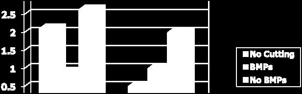
4 Sediment and Nutrient Yield 20 acres, 2 years BMPs Timber harvest planning Streamside management zones Wetlands Stream crossings Road planning and construction Harvest area 4


5 Timber Harvest Planning Tactical planning When to harvest particular tracts When to build roads and landings Operational planning Road, trail, and landing location Stream crossings Slopes Soils Road and crossing construction Drainage Surfacing Selection and size Water Quality Protection by SMZs Temperature Organic matter Nutrients Sediment 5
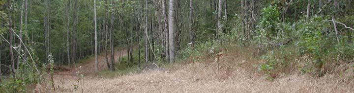
6 Riparian Area Important to system health/function Provides shade Provides organic matter input Delays water release Traps sediment Ties up nutrients SMZ Perennial Streams Tree cover at least 50% canopy, 35 feet from the bank, for wildlife 50 feet Shading Leaf and twig input for food and habitat Tree falls for habitat Bank trees for channel stability Avoid disturbance >= 35 ft from stream bank Comply with stream crossing BMPs 6
7 SMZ Perennial Streams Tree cover Avoid disturbance >= 35 ft from stream bank Leaf and plant cover minimize erosion within the SMZ Leaf and plant cover slow upland runoff and drop out sediment Undisturbed soil maximizes infiltration of runoff and rainfall Plant growth removes nutrients from runoff Comply with stream crossing BMPs SMZ Intermittent Streams Avoid disturbance >= 35 ft from stream bank Maintain leaf litter and ground cover Comply with stream crossing BMPs 7


8 SMZ Ephemeral channel No specific requirements Avoid disturbance near streams and to stream banks SMZ - Wildlife Habitat Wider SMZ (50 ft) for use as corridors or habitat Mast (hard mast) producing species retained Recognition of timber type boundaries outside of SMZ Riparian areas 8
9 Wetlands USACE Federal Manual for Delineating Jurisdictional Wetlands May include: Coves and lower slopes, Branch bottoms, Creek bottoms, River bottoms, Muck swamps, Peat swamps and cypress/gum ponds, and wet fiats Alteration of land use in wetland requires 404 4permit Silviculture operations exempt from 404 if BMPs are followed Intention is to maintain land use Good idea to have mgmt plan to support exempt status Fifteen federal Mandatory BMPs (Page 19) Federal Wetland BMPS 1. Roads and trails should be the minimum feasible number, width, and total length 2. Roads and trails should be located sufficiently far from streams or other water bodies (except for crossings) ; 3. Road fill shall be bridged, culverted or otherwise designed to prevent the restriction of expected flood flows; 4. Road fill shall be properly stabilized and maintained during and following construction to prevent erosion 9
10 Federal BMPS 5. Minimize machine traffic outside the fill area; 6. Minimize disturbance of vegetation in designing, constructing and maintaining roads; 7. Design, construction and maintenance of the road crossing shall not disrupt movement of aquatic species 8. Borrow material shall be taken from upland sources whenever feasible Federal BMPS 9. The discharge shall not take, or jeopardize the continued existence of a threatened or endangered species as defined under the Endangered Species Act, or adversely modify or destroy the critical habitat of such species; 10. Discharges into breeding and nesting areas for water fowl, spawning and wetlands shall be avoided if less harmful alternatives exist; 10
11 Federal BMPS 11. No fill in the proximity of a public water supply intake; 12. No fill in areas of concentrated shellfish production; 13. No fill in a component of the National Wild and Scenic River System; 14. Fill must be free from toxic pollutants in toxic amounts; and 15. All temporary fills shall be removed in their entirety and the area restored to its original elevation. Wetland BMPs Perennial SMZs Perimeter of major drainage Along any open water (oxbow, sloughs) Restore any minor alterations in drainage to preharvest conditions Road construction should not affect hydrology Cross drainage Fill 11
12 Stream Crossing Impact Link upland sources of sediment to streams Sediment from crossing construction and use Sediment from poor construction and failure Barriers to fish passage Stream Crossing BMPs Minimize number of crossings Expensive and major source of sediment Layout and type Crossing location Approach design Choice of crossing Maintenance and removal 12
13 Crossing location Minimize length of road in floodplain Minimize slope into crossing Avoid locations with wide channels, multiple channels, or wide floodplains Cross perpendicular to stream flow Road Approach Design Straight road (50 ft) into the crossing A curve into the crossing Increases the disturbance in the flood plain Increases the crossing width (longer culverts, wider bridges) Angled/curved roads may lead to bank erosion following flooding Increases disturbance in the SMZ 13
14 Road Approach Design Road surface drainage Slope road surface Construct broadbased dips Surface road with rock and grass especially highly erodible steep slope Direct runoff into SMZ Not into ditch that dumps into stream Minimize slope into crossing Choice of Crossing Fords Natural and constructed Culverts Bridges Temporary and permanent 14

15 Fords Low bank height Hard bottom Constructed Hardbottom made with geotextile, rock, and geoweb Challenges Sediment from construction and use Least suitable for all season roads Avoid damming or adding fill to stream Ford Design 15
16 Culverts Proper installation techniques Culvert size Based on acreage and landform for 20? year event Accommodate high flow in approach Low spot in approach should be just above culvert top and away from the main channel Culverts Long term issues Removal Maintenance Sediment from construction and use less than ford Culvert failure is a major source of sediment 16
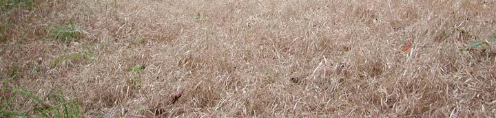
 Width of road + Width")
17 Streams: Culvert Sizing Recommended Culvert Diameter (Table II, Page 7) Drain area (ac) L. Coastal Plain U. Coastal Plain Piedmont Mountains x 48 Culvert Installation Length of culvert (ft) Width of road + Width of fill slope * Short culverts Buried by fill slopes 17
18 Culvert Length Road Surface 15 ft 18 fill 1:1 Fill slope 36 pipe =4.5 ft +1ft +1ft 4.5 ft 15 ft 4.5 ft =26 ft Multiple culverts 36 inch pipe with 18 inch fill 2*24 inch pipes pp with 12 inch fill 18

19 Culvert Failure Culvert too small Culvert too short Culvert installed poorly Incorrect slope of culvert Culvert poorly tamped in Outlet or inlet above channel Too little fill overtop Inlet unprotected Poor location Culvert Failure High water design/relief Culvert damage Crushed ends Debris dams Sedimentation of inlet and culvert 19


20 Bridges For truck roads Highly engineered Well designed approaches and sills For skid trails Standard bridge sections of metal or wood Relatively short span Least sediment since little l or no in-stream activity Most expensive for permanent crossings, low cost per use for temporary crossings Skidder Bridge with Slash Mat 20
21 Crossings with Fill Logs, slash, rock or soil crossings are undesirable Difficult to restore channel Federal BMPS If it restricts flow it violates 3 If it is on a perennial stream it violates 7 If it is not removed following activity it violates 15 Road Construction and Planning Minimize road grade Avoid SMZs other than crossings Avoid highly erodible soils Avoid dredge and fill in wetlands or in locations that may reach the waters of the state Avoid old roads, ditches and gullies that are highly eroded 21


22 Road Construction Design to likely traffic levels Log right-of-way before clearing and grubbing Don t bury stumps or logs Minimize cut and fill slopes Install road drainage and water diversion 22
23 Road Drainage Slope of road surface 2-4% to prevent water traveling down the road surface Crowned Outslope Inslope Turnout (wing) ditches moves water from road edge or ditch to undisturbed soil Distance between turnouts dependent on road slope Intervals Between Structures Distance between Distance between Broad-based % Slope water bars dips, turnouts TABLE 3, PAGE 12 23

24 Road Drainage Culverts move water from channels or ditches under road Avoid excess volume in the ditch ditch erosion Avoid water running over road Distance between culverts based on road slope Broad-based dips on inslope or outslope roads divert runoff into turn out or wing ditch Road Drainage: Broad-based Dips Effective way to divert water from permanent road that does not interfere with truck of skidder traffic Outslope of 3% Depth of 9-15 inches Fill with crushed rock 24
25 Broad Based Dips Road Maintenance Protect culvert or wing ditch outfall from erosion with rock or organic debris, especially on steep terrain Control traffic Ruts on road counteract slope (crown, inslope, outslope) channel water down the road, and wear down BBD s Establish vegetation on less travelled roads Rock surface main roads and steep slopes Mulch fill and cut slopes where vegetation won t be quickly established 25
26 Harvest Area Locate landings and trails outside of SMZs and drainage pattern Landings Uphill, gently sloping Skid trails avoid steep slopes have breaks in slope when steep slopes are necessary Felling Do not leave trees, tops, or slash in streams Maintain recommended tree cover in SMZs Retirement Harvest Area Retirement Trails and temporary roads Establish water bars at recommended distances Restore natural drainage Remove ruts especially on steep terrain, low areas Remove debris and fill from streams and channels Revegetation ti seed, fertilize, lime highly hl erodible areas Landings 26


27 Types of Water Bars Shallow Constructed prior to and during logging, temporary structure Deep Use of road or trail is finished, permanent structure Water Bar and BBD Failure Berm erodes Berm is fill material and gets waterlogged Too much runoff Not high enough Traffic over the berm (when wet) Depression fills with sediment Angle too shallow No outlet Slope Outlet erodes Angle too steep Road or roadside too steep Outlet in to ditch or stream 27
28 Intervals Between Structures Depends on Road Gradient Distance between Distance between Broad-based % Slope water bars dips, turnouts TABLE 3, PAGE 12 Harvest Area Retirement Trails and temporary roads Landings Address debris piles (knock down, redistribute, burn) Smooth, restore drainage Revegetate Trash disposal 28


29 Revegetation Follow recommendations in Erosion Control & Wildlife Planting for Forestry Operations Get local advice for best, low cost high success cover planting Georgia BMP Implementation

 Northern (05-06) Aerial survey of 635 harvest")
, 3 sites out of compliance Southern")
,")
30 Georgia BMP Compliance % of problem crossings were skidder fords and debris type crossings Alabama Inspections 2007, 35 complaints, 5 (1 forestry related) turned over to ADEM (enforcement) Northern (05-06) Aerial survey of 635 harvest sites, 3 sites out of compliance Ground survey of 112 harvest sites (subset of 635), 3 sites out of compliance Southern (06-07) Aerial survey of 700 harvest sites, 2 sites out of compliance Ground survey of 147 harvest sites (subset of 700), 2 sites out of compliance 30
ALABAMA S BEST MANAGEMENT PRACTICES. Protection of Water Quality During Timber Harvesting
 ALABAMA S BEST MANAGEMENT PRACTICES Protection of Water Quality During Timber Harvesting Water Quality Responsibility Landowners and/or involved professional forestry practitioners such as: Forest resource
Virginia Department of Forestry Water Resources Program. Chesapeake Bay Forestry Workgroup Meeting April 8, 2014
 Virginia Department of Forestry Water Resources Program Chesapeake Bay Forestry Workgroup Meeting April 8, 2014 VDOF Mission for Forestry in Virginia We protect and develop healthy, sustainable forest
W. Goodrich Jones State Forest. Best Management Practices Virtual Demonstration Tour
 W. Goodrich Jones State Forest Best Management Practices Demonstrations of commonly implemented Texas Forestry BMPs for Water Quality Protection Texas Forest Service Water Resources P.O. Box 310 Lufkin,
WEST VIRGINIA DIVISION OF FORESTRY STATE FOREST STANDARDS for LOGGING ROADS AND SKID TRAILS HAUL ROADS
 WEST VIRGINIA DIVISION OF FORESTRY STATE FOREST STANDARDS for LOGGING ROADS AND SKID TRAILS HAUL ROADS The objective of these specifications is to provide the construction requirements for haul roads and
Fire Management CONTENTS. The Benefits of Guidelines...3 Considerations...4
 Fire Management CONTENTS Fire Management 1 Introduction...3 The Benefits of Guidelines...3 Considerations...4 Planning...5 Burn Plan Development...5 Operational Activities...8 Pre-Ignition Activities...8
TEXAS FORESTRY BEST MANAGEMENT PRACTICES
 TEXAS FORESTRY BEST MANAGEMENT PRACTICES August 2017 This publication, funded by the Texas Forestry Association, combines the Texas Best Management Practices for Silviculture and Texas Best Management
WEST VIRGINIA DIVISION OF FORESTRY STATE FOREST STANDARDS for LOGGING ROADS AND SKID TRAILS HAUL ROADS
 WEST VIRGINIA DIVISION OF FORESTRY STATE FOREST STANDARDS for LOGGING ROADS AND SKID TRAILS HAUL ROADS The objective of these specifications is to provide the construction requirements for haul roads and
Temporary Watercourse Crossing: Culverts
 Temporary Watercourse Crossing: Culverts DRAINAGE CONTROL TECHNIQUE Low Gradient Velocity Control Short Term Steep Gradient Channel Lining Medium-Long Term Outlet Control Soil Treatment Permanent Symbol
Erosion and Sediment Pollution Control Guidelines for Residential Lots with soil disturbance of less than 1 acre (see exceptions)
") Adams Co. Conservation District 670 Old Harrisburg Road, Suite 201 Gettysburg, PA 17325 Telephone: 334-0636 Fax: 337-0730 www.adamscounty.us Erosion and Sediment Pollution Control Guidelines for Residential
Adams Co. Conservation District 670 Old Harrisburg Road, Suite 201 Gettysburg, PA 17325 Telephone: 334-0636 Fax: 337-0730 www.adamscounty.us Erosion and Sediment Pollution Control Guidelines for Residential
Erosion and Sediment Control Plan for a Timber Harvesting Operation
 3930-FM-WM0155 Rev. 7/2004 Erosion and Sediment Control Plan for a Timber Harvesting Operation 1. GENERAL INFORMATION A. Location Municipality B. Timber sale area = acres Date County C. Landowner Name
TEXAS FORESTRY BEST MANAGEMENT PRACTICES
 TEXAS FORESTRY BEST MANAGEMENT PRACTICES August 2004 This reprint, funded by the Texas Forestry Association, combines the Texas Best Management Practices for Silviculture and Texas Best Management Practices
IMPLEMENTATION OF FORESTRY BEST MANAGEMENT PRACTICES IN TENNESSEE
 IMPLEMENTATION OF FORESTRY BEST MANAGEMENT PRACTICES IN TENNESSEE Results from the 2007 Forestry BMP Implementation Survey TENNESSEE DEPARTMENT OF AGRICULTURE DIVISION OF FORESTRY, 2009 IMPLEMENTATION
In Cooperation with: Illinois Department of Natural Resources. Illinois Forestry Development Council. University of Illinois
 In Cooperation with: Illinois Department of Natural Resources Illinois Forestry Development Council University of Illinois acknowledgments The following steering committee members were instrumental in
Forest Recreation Management
 Forest Recreation Management 1 Forest Recreation Management Introduction...3 CONTENTS The Benefits of Guidelines...3 Considerations...4 Planning...5 Construction of Recreation Areas...6 Protecting Cultural
Understanding Stormwater Pollution Prevention Plans (SWPPPs) (SWPPPS)
 (SWPPPS)") Understanding Stormwater Pollution Prevention Plans (SWPPPs) (SWPPPS) Definitions SWPPP: Storm Water Pollution Prevention Plan BMP: Best Management Practice(s) to control pollution IDNR: Iowa Department
Understanding Stormwater Pollution Prevention Plans (SWPPPs) (SWPPPS) Definitions SWPPP: Storm Water Pollution Prevention Plan BMP: Best Management Practice(s) to control pollution IDNR: Iowa Department
BEST MANAGEMENT PRACTICES FOR FORESTED WETLANDS IN THE SOUTHERN APPALACHIAN REGION
 BEST MANAGEMENT PRACTICES FOR FORESTED WETLANDS IN THE SOUTHERN APPALACHIAN REGION W. Michael Aust Department of Forestry, 228 Cheatham Hall, Virginia Polytechnic Institute & State University, Blacksburg,
CITY OF SPRING HILL Water Quality Buffer Zone Policy (Adopted April 22, 2008)
") Section I - Description CITY OF SPRING HILL Water Quality Buffer Zone Policy (Adopted April 22, 2008) A water quality buffer zone (a.k.a. a riparian zone) is a strip of undisturbed native (indigenous)
Section I - Description CITY OF SPRING HILL Water Quality Buffer Zone Policy (Adopted April 22, 2008) A water quality buffer zone (a.k.a. a riparian zone) is a strip of undisturbed native (indigenous)
CHAPTER 6 ADDITIONAL STANDARDS APPLYING TO SHORELAND AREAS AND PUBLIC WATERS
 CHAPTER 6 ADDITIONAL STANDARDS APPLYING TO SHORELAND AREAS AND PUBLIC WATERS Section 1 Intent. 49 Section 2 Floodplain Requirements 49 Section 3 Water-Oriented Accessory Structures 50 Section 4 Stairways,
Mechanical Site Preparation
 Mechanical Site Preparation 1 Mechanical Site Preparation Introduction...3 CONTENTS The Benefits of Guidelines...3 Considerations...5 Design Outcomes To Maintain Soil Productivity...6 Planning...7 Planning
NEW CASTLE CONSERVATION DISTRICT. through. (Name of Municipality) PLAN REVIEW APPLICATION DRAINAGE, STORMWATER MANAGEMENT, EROSION & SEDIMENT CONTROL
 PLAN REVIEW APPLICATION DRAINAGE, STORMWATER MANAGEMENT, EROSION & SEDIMENT CONTROL") NEW CASTLE CONSERVATION DISTRICT through (Name of Municipality) PLAN REVIEW APPLICATION DRAINAGE, STORMWATER MANAGEMENT, EROSION & SEDIMENT CONTROL Office use only: Received by Municipality: Received by
NEW CASTLE CONSERVATION DISTRICT through (Name of Municipality) PLAN REVIEW APPLICATION DRAINAGE, STORMWATER MANAGEMENT, EROSION & SEDIMENT CONTROL Office use only: Received by Municipality: Received by
Nancy L. Young, Forester USAID/USDA Natural Resources Conservation Service
 Forest Management Nancy L. Young, Forester USAID/USDA Natural Resources Conservation Service Material translated by: Mohammadullah Karimi, Training & Liaison Officer Afghan Conservation Corps Managing
Best Management Practices
 Forestry Best Management Practices to Protect Water Quality in Colorado 2010 Contents Introduction... 1 Watersheds... 2 Planning... 3 Roads... 4 Planning, Design and Location... 4 Standards and Use...
N.C. Forest Service Organization
 Forestry Operations in N.C.: Water Quality regs, BMPs, and E&SC WRRI Erosion & Sedimentation Control Planning and Design Workshop Hickory NC -- April 28, 2016 Tom Gerow: NCFS Water Resources Staff Forester,
Best Practices for Building High-Performance Resource Roads. Road Drainage. Developed by: The Roads and Infrastructure Group
 Best Practices for Building High-Performance Resource Roads Road Drainage Developed by: The Roads and Infrastructure Group THIS GUIDE IS INTENDED FOR EQUIPMENT OPERATORS CONSTRUCTION CONTRACTORS FIELD
Town of Essex, Vermont January, 2017 Standard Specifications For Construction CHAPTER 3 EROSION AND SEDIMENT CONTROL
 CHAPTER 3 EROSION AND SEDIMENT CONTROL CHAPTER 3 EROSION AND SEDIMENT CONTROL Section 300 General Summary All projects constructed within the Town of Essex shall be constructed in strict accordance with
CHAPTER 3 Environmental Guidelines for WATERCOURSE CROSSINGS GOVERNMENT OF NEWFOUNDLAND AND LABRADOR DEPARTMENT OF ENVIRONMENT AND LABOUR
 GOVERNMENT OF NEWFOUNDLAND AND LABRADOR DEPARTMENT OF ENVIRONMENT AND LABOUR CHAPTER 3 Environmental Guidelines for WATERCOURSE CROSSINGS WATER RESOURCES MANAGEMENT DIVISION Water Investigations Section
Home Manage Your Forest Protect Your Forest Help Your Community Kids, Teachers & Everyone Site Map. Arkansas Forestry Commission BMP Review
 Arkansas Forestry Commission BMP Review The publication "Best Management Practices for Water Quality Protection" is available in PDF format and may be viewed using Adobe Acrobat Reader. You may download
Best Management Practices (BMPs)
") Appendix B Best Management Practices (BMPs) Prepared by: Rebecca Quinones, Tom Laurent and Polly Haessig Best Management Practices (BMPs) are measures certified by the State Water Quality Board and approved
Appendix B Best Management Practices (BMPs) Prepared by: Rebecca Quinones, Tom Laurent and Polly Haessig Best Management Practices (BMPs) are measures certified by the State Water Quality Board and approved
West Virginia BMP Manual Date 2014 BMP Manual Regulatory BMP Monitoring
 BMP Manual State State BMP Regulation BMP Monitoring West Virginia BMP Manual Date 2014 BMP Manual http://www.wvforestry.com/dofbmpmanual2014.pdf Regulatory BMP Monitoring Most Recent Monitoring: 2015
Holly Swartz and Jason Shirey
 Chapter 105 General Permits for Stream and Wetland Impacts DEP Ch. 105 CONTACTS FOR BERKS COUNTY: Holly Swartz and Jason Shirey What DEP Regulates Under Chapter 105 Waters of the Commonwealth, which includes
APPENDIX E. CONSTRUCTION SPECIFICATIONS FOR ACCESS ROADS (January 2005)
") APPENDIX E CONSTRUCTION SPECIFICATIONS FOR ACCESS ROADS (January 2005) i TABLE OF CONTENTS 1.0 INTRODUCTION...1 2.0 CONSTRUCTION SPECIFICATIONS FOR ACCESS ROADS................... 1 3.0 PLANNING AND LOCATION...2
APPENDIX E CONSTRUCTION SPECIFICATIONS FOR ACCESS ROADS (January 2005) i TABLE OF CONTENTS 1.0 INTRODUCTION...1 2.0 CONSTRUCTION SPECIFICATIONS FOR ACCESS ROADS................... 1 3.0 PLANNING AND LOCATION...2
Riparian Buffer Requirements. Department of Environmental Protection Bureau of Watershed Management
 102.14 - Riparian Buffer Requirements Department of Environmental Protection Bureau of Watershed Management 102.2 Scope and Purpose BMPs to protect, maintain, and restore water quality and existing designated
Chapter 10 Natural Environment
 Chapter 10 Natural Environment Existing Conditions The Natural Environment Element addresses the protection, conservation, preservation, and restoration of the natural resources the Bayview Ridge Subarea,
CHAPTER 8 EROSION AND SEDIMENT CONTROL PLAN REQUIREMENTS
 CHAPTER 8 EROSION AND SEDIMENT CONTROL PLAN REQUIREMENTS 8.1 INTRODUCTION To minimize the detrimental effects of erosion and sedimentation, Henrico County requires that those individuals responsible for
Diversion Dikes. Fe=0.95
 2.2 Diversion Dike Erosion Control Description: A diversion dike is a compacted soil mound, which redirects runoff to a desired location. The dike is typically stabilized with natural grass for low velocities
APPENDIX A AQUATIC/RIPARIAN SPECIES AND HABITAT PROJECT DESIGN CRITERIA
 APPENDIX A AQUATIC/RIPARIAN SPECIES AND HABITAT PROJECT DESIGN CRITERIA Development of design criteria for aquatic and riparian species and habitats with treatments proposed within occupied or suitable
SW-74 SERENOVA PRESERVE SITES 2, 3, 4, 8 MITIGATION PLAN
 SW-74 SERENOVA PRESERVE SITES 2, 3, 4, 8 MITIGATION PLAN BACKGROUND INFORMATION Project SWIM? Aquatic Control? Exotic Control? Mitigation Bank? Type No No No No Mitigation Restoration and enhancement Type
Conditions of Section 401 Certification for Nationwide Permits and General Conditions. General Condition 12 (Soil Erosion and Sediment Controls)
") Conditions of Section 401 Certification for Nationwide Permits and General Conditions General Condition 12 (Soil Erosion and Sediment Controls) Erosion control and sediment control BMPs described in Attachment
Conditions of Section 401 Certification for Nationwide Permits and General Conditions General Condition 12 (Soil Erosion and Sediment Controls) Erosion control and sediment control BMPs described in Attachment
Erosion & Sedimentation Control Policy
 Issue Date 10/22/2010 Page 1 of 8 Erosion & Sedimentation Control Policy Introduction: Soil erosion is the removal of soil by water, wind, ice or gravity and sediment deposition occurs when the rate of
Section 3 Guidelines for Forest Roads
 Section 3 Guidelines for PART 1. OVERVIEW... 2 PART 2. ROAD MAINTENANCE AND ABANDONMENT PLANNING... 2 2.1 Road Maintenance and Abandonment Plans... 2 2.2 Changes in Ownership... 3 2.3 Family Forest Fish
Stormwater Local Design Manual For Houston County, Georgia
 Stormwater Local Design Manual For Houston County, Georgia Adopted November 15, 2005 TABLE OF CONTENTS 1. FORWARD... 1 2. GENERAL LEVEL OF SERVICE STANDARDS... 2 2.1. DETENTION REQUIREMENTS... 2 2.1.1.
Constructed Wetland Pond T-8
 Constructed Wetland Pond T-8 Description A constructed wetlands pond is a shallow retention pond designed to permit the growth of wetland plants such as rushes, willows, and cattails. Constructed wetlands
901 STORMWATER POLLUTION MANAGEMENT SECTION 901 STORMWATER POLLUTION MANAGEMENT
 SECTION 901 STORMWATER POLLUTION MANAGEMENT 901.1 DESCRIPTION Design, implement, inspect and maintain appropriate best management practices to minimize or eliminate erosion, sediment and other pollutants
Appendix E. Best Management Practices
 Appendix E. Best Management Practices INTRODUCTION The Forest Service is required by law to comply with water quality standards developed under authority of the Clean Water Act. The Environmental Protection
Soil Resources Analysis Hurricane Ivan-RCW Expansion Project Conecuh National Forest
 Soil Resources Analysis Hurricane Ivan-RCW Expansion Project Conecuh National Forest Current Conditions of Soil Resources: The project area is wide spread across the forest, the result of a large scale
POLICY FOR NATURAL RESOURCE MANAGEMENT AREAS
 POLICY FOR NATURAL RESOURCE MANAGEMENT AREAS I. POLICY STATEMENT Auburn University's (the University's) "Policy for Natural Resource Management Areas" implements the Campus Master Plan Land Use Element
CONTENTS EXECUTIVE SUMMARY STUDY METHODS MONITORING RESULTS COMPLIANCE TRENDS OTHER FINDINGS CONCLUSION
 FORESTRY BMPs IN SOUTH CAROLINA Compliance and Implementation Monitoring Report, 2011-2014 1 CONTENTS EXECUTIVE SUMMARY STUDY METHODS Compliance and Implementation Monitoring of Forestry Best Management
MODEL Stormwater Local Design Manual. City of Centerville
 MODEL Stormwater Local Design Manual City of Centerville Adopted December 6, 2005 TABLE OF CONTENTS 1. FORWARD... 1 2. GENERAL LEVEL OF SERVICE STANDARDS... 1 2.1. DETENTION REQUIREMENTS... 1 2.1.1. Discharge
Maintaining Riparian Areas and Wetlands
 Maintaining Riparian Areas and Wetlands Riparian areas are the lands along the banks of our rivers, lakes, and tidal waters. Many riparian areas not only border surface waters, but they are often adjacent
Constructed Wetland Use in Nonpoint Source Control
 Constructed Wetland Use in Nonpoint Source Control Description Constructed wetlands are excavated basins with irregular perimeters and undulating bottom contours into which wetland vegetation is purposely
RIPARIAN CORRIDOR STUDY FINAL CITY CREEK MANAGEMENT PLAN TABLE OF CONTENTS
 TABLE OF CONTENTS 1.0 INTRODUCTION... 1-1 Riparian Corridor Study and Management Plan Goals... 1-1 Study Area... 1-2 Importance and Functions of Riparian Corridors... 1-2 Habitat for Mammals, Birds, and
GRASS-LINED CHANNEL (acre) CODE 840
 CODE 840") NATURAL RESOURCES CONSERVATION SERVICE ILLINOIS URBAN MANUAL PRACTICE STANDARD GRASS-LINED CHANNEL (acre) CODE 840 (Source: NC Erosion and Sediment Control Field Manual) DEFINITION A natural or constructed
NATURAL RESOURCES CONSERVATION SERVICE ILLINOIS URBAN MANUAL PRACTICE STANDARD GRASS-LINED CHANNEL (acre) CODE 840 (Source: NC Erosion and Sediment Control Field Manual) DEFINITION A natural or constructed
STORMWATER DISCHARGES ASSOCIATED WITH CONSTRUCTION ACTIVITY
 STATE OF COLORADO GENERAL PERMIT APPLICATION Updated 11/04 STORMWATER DISCHARGES ASSOCIATED WITH CONSTRUCTION ACTIVITY This application is for use by all stormwater dischargers engaged in construction
Construction Best Management Practices Handbook BEST MANAGEMENT PRACTICES
 Construction Best Management Practices Handbook www.montereysea.org BEST MANAGEMENT PRACTICES 26 www.montereysea.org Construction Best Management Practices Handbook VEHICLE TRACKING AND DUST CONTROL IN
NJDEP Regulations that impact or soon will impact agricultural operations. April 1, 2007 Horses 2007
 NJDEP Regulations that impact or soon will impact agricultural operations. April 1, 2007 Horses 2007 Peter L. Kallin, Ph.D., P.W.S. Phone: 732-499-3600 Ext. 237 E-mail: pkallin@aesop.rutgers.edu www.water.rutgers.edu
PART 1 GENERAL REQUIREMENTS
 PART 1 GENERAL REQUIREMENTS Contract Closeout Plan 110 Arrow diagram for project close-out...3 Erosion Control 121 Straw bale barrier... 5 122 Silt fence... 7 123 Diversion dike... 9 124 Inlet protection...
COON CREEK WATERSHED DISTRICT PERMIT REVIEW. Spring Lake Park Schools Westwood Middle School st Avenue NE, Spring Lake Park, MN 55432
 PAN 16-112, Westwood Middle School, Page 1 of 6 COON CREEK WATERSHED DISTRICT PERMIT REVIEW MEETING DATE: August 22, 2016 AGENDA NUMBER: 10 FILE NUMBER: 16-112 ITEM: Westwood Middle School RECOMMENDATION:
JEFFERSON COUNTY STORM WATER MANAGEMENT
 JEFFERSON COUNTY STORM WATER MANAGEMENT B-210 Courthouse, Birmingham, Alabama 35203 Telephone: (205) 325-8741 Erosion and Sedimentation Control Measures for Commercial Projects (Plans Requirements) -All
VEGETATIVE, WATER, FISH AND WILDLIFE RESOURCES POLICIES
 VEGETATIVE, WATER, FISH AND WILDLIFE RESOURCES POLICIES The County will: GOALS AND OBJECTIVES 1.1 Conserve, Enhance, Protect, Maintain and Manage Vegetative, Water, Fish and Wildlife Resources Promote
Standards for Soil Erosion and Sediment Control in New Jersey May 2012 STANDARD FOR GRASSED WATERWAYS. Definition. Purpose
 STANDARD FOR GRASSED WATERWAYS Definition A natural or constructed watercourse shaped or graded in earth materials and stabilized with suitable vegetation for the safe conveyance of runoff water. Purpose
Voluntary Compliance with Forestry Best Management Practices in East Texas
 Voluntary Compliance with Forestry Best Management Practices in East Texas Results from Round 3 of BMP Compliance Monitoring by Burl Carraway, BMP Project Leader Larry Clendenen, BMP Project Forester Donna
WATERSHED. Maitland Valley. Report Card 201
 Maitland Valley WATERSHED Report Card 201 The Maitland Valley Conservation Authority has prepared this report card as a summary on the state of our forests, wetlands, surface water, and ground water resources.
For the property described as: Property Owner: Name. Phone Number. Mailing Address. City. Report Year:
 Timber Management Plan For the property described as: Property Owner: Name Phone Number Mailing Address City State Zip Report Year: (This template is provided to assist Cherokee County land owners who
Annex 1 FOREST MANAGEMENT PLAN VTS-MILAN Integrated Natural Resources Management Plan 1-1 VTS-Milan
 Annex 1 FOREST MANAGEMENT PLAN VTS-MILAN 2010-2016 Integrated Natural Resources Management Plan 1-1 Annex 1 Forest Management Integrated Natural Resources Management Plan 1-2 Annex 1 Forest Management
Training on Roads for Water and Resilience
 Training on Roads for Water and Resilience 1 DRAINAGE FROM UNPAVED ROADS Outline 3 1. 2. 3. 4. 5. 6. 7. Introduction Important considerations Drainage management Surface drainage features Subsurface drainage
Department of the Army Permit Application
 Department of the Army Permit Application DA File Number U.S. Army Corps of Engineers Honolulu District Date Received by CEPOH-RO Send Completed Application to: Honolulu District, U.S. Army Corps of Engineers
LITTLE SHADES CREEK RESTORATION PROJECT CWA Section 319(h) Nonpoint Source Implementation Grant Project Workplan #17 ADEM Contract #C
 Nonpoint Source Implementation Grant Project Workplan #17 ADEM Contract #C") LITTLE SHADES CREEK RESTORATION PROJECT CWA Section 319(h) Nonpoint Source Implementation Grant Project Workplan #17 ADEM Contract #C90593066 PARTNERS Alabama Department of Environmental Management Cawaco
LITTLE SHADES CREEK RESTORATION PROJECT CWA Section 319(h) Nonpoint Source Implementation Grant Project Workplan #17 ADEM Contract #C90593066 PARTNERS Alabama Department of Environmental Management Cawaco
PRESENTERS. Contact Information: RW Armstrong Union Station, 300 S. Meridian St. Indianapolis, IN
 1 PRESENTERS David Bourff, Director of Environmental Planning Simon Davies, LEED AP, Environmental Scientist Summer O Brien, PWS, Senior Environmental Scientist Contact Information: RW Armstrong Union
North Carolina. Forestry Best Management Practices Manual. To Protect Water Quality
 North Carolina Forestry Best Management Practices Manual To Protect Water Quality Amended September 2006 North Carolina Forestry Best Management Practices Manual To Protect Water Quality. Amended September
Portable Skidder Bridges Amy Thompson and Jeff Stringer
 UNIVERSITY OF KENTUCKY COLLEGE OF AGRICULTURE THE KENTUCKY L GJAM Spring 2003 Volume 7 No. 3 COOPERATIVE EXTENSION SERVICE ONE HOUR CONTINUING EDUCATION CREDIT Portable Skidder Bridges Amy Thompson and
Natural and Engineered Wetlands for Stormwater Management
 Natural and Engineered Wetlands for Stormwater Management Dan Hitchcock, Ph.D., P. E. Baruch Institute of Coastal Ecology and Forest Science Clemson University Georgetown, SC Prominence and Diversity of
RIPARIAN CORRIDOR STUDY FINAL PARLEYS CREEK MANAGEMENT PLAN TABLE OF CONTENTS
 TABLE OF CONTENTS 1.0 INTRODUCTION... 1-1 Riparian Corridor Study and Management Plan Goals... 1-1 Study Area... 1-2 Importance and Functions of Riparian Corridors... 1-2 Habitat for Mammals, Birds, and
Modular Sediment Barriers (Instream)
") Modular Sediment Barriers (Instream) INSTREAM PRACTICES Flow Control No Channel Flow Dry Channels Erosion Control Low Channel Flows Shallow Water Sediment Control High Channel Flows Deep Water Symbol Photo
Modular Sediment Barriers (Instream) INSTREAM PRACTICES Flow Control No Channel Flow Dry Channels Erosion Control Low Channel Flows Shallow Water Sediment Control High Channel Flows Deep Water Symbol Photo
Environmental Information Worksheet
 Environmental Information Worksheet Water System Owner (Attach additional sheets if necessary) Needs and Alternatives Provide a brief narrative that describes: Current drinking water system needs. Project
901 - TEMPORARY EROSION AND POLLUTION CONTROL SECTION 901 TEMPORARY EROSION AND POLLUTION CONTROL
 SECTION 901 TEMPORARY EROSION AND POLLUTION CONTROL 901.1 DESCRIPTION Install, maintain and remove temporary erosion and pollution control devices as required during the construction of the project. BID
Wyoming Forestry Best Management Practices
 Wyoming Forestry Best Management Practices Forest Stewardship Guidelines for Water Quality 2011 Field Audit Report Office of State Lands and Investments Wyoming State Forestry Division January 2012 Table
DRAFT FINDING OF NO SIGNIFICANT IMPACT. for. Tioga Sports Park
 DRAFT FINDING OF NO SIGNIFICANT IMPACT for Tioga Sports Park The U.S. Fish and Wildlife Service (USFWS) prepared an Environmental Assessment (EA) to analyze the potential effects of the proposal by the
A. C-I ROAD RULES APPENDIX C: 14 CCR DEFINITIONS.
 CALIFORNIA BOARD OF FORESTRY AND FIRE PROTECTION 357 APPENDIX C: California Board of Forestry and Fire Protection 2013 Road Rules and Technical Addendum No. 5: Guidance on hydrologic disconnection, road
Funding Guidelines State Fiscal Year 2016
 State Fiscal Year 2016 Water Quality Financial Assistance Centennial Clean Water Program Clean Water Act Section 319 Program Stormwater Financial Assistance Program Washington State Water Pollution Control
Sustainable Non-Agriculture Land Management
 Forest, Wetlands and Habitat Verification Checklist A boxed risk level indicates the level required for environmental assurance verification. Bold black print indicates a violation of state or federal
Straw Bale Barrier. - Along the face and at grade breaks of exposed and erodible slopes to shorten slope length and spread runoff as sheet flow
 Straw Bale Barrier SE-9 Objectives EC Erosion Control SE Sediment Control TR Tracking Control WE Wind Erosion Control Non-Stormwater NS Management Control Waste Management and WM Materials Pollution Control
15A NCAC 02B.0267 JORDAN WATER SUPPLY NUTRIENT STRATEGEY: PROTECTION OF EXISTING RIPARIAN BUFFERS (See S.L ) Protection of the nutrient
 Protection of the nutrient") 15A NCAC 02B.0267 JORDAN WATER SUPPLY NUTRIENT STRATEGEY: PROTECTION OF EISTING RIPARIAN BUFFERS (See S.L. 2013-395) Protection of the nutrient removal and other water quality benefits provided by riparian
15A NCAC 02B.0267 JORDAN WATER SUPPLY NUTRIENT STRATEGEY: PROTECTION OF EISTING RIPARIAN BUFFERS (See S.L. 2013-395) Protection of the nutrient removal and other water quality benefits provided by riparian
Forest Practices and the Hummingbird Creek Debris Flow
 Forest Practices and the Hummingbird Creek Debris Flow Complaint Investigation 990189 FPB/IRC/50 August 2001 Table of Contents The Investigation...1 Background...1 Relevant Legislation...3 Discussion...3
STORMWATER RUNOFF AND WATER QUALITY IMPACT REVIEW
 SUBCHAPTER 8 STORMWATER RUNOFF AND WATER QUALITY IMPACT REVIEW 7:45-8.1 Purpose and scope of review Except for those projects expressly exempted by this chapter or waived by the Commission, the Commission
Ordinance No Lot Surface Drainage
 Ordinance No. 35-2008 - Lot Surface Drainage The Township has adopted a new Lot Surface Drainage Ordinance which amends Chapter 170, Article IX, Subdivision and Site Plan Review by adding a new Section
iswm TM Criteria Manual City of Azle Section 14 City of Azle Subdivision Ordinance DRAFT-June Chapter 1
 City of Azle Section 14 City of Azle Subdivision Ordinance DRAFT-June 2010... Chapter 1 i CITY OF AZLE iswm CRITERIA MANUAL FOR SITE DEVELOPMENT AND CONSTRUCTION Incorporating the Regional NCTCOG Integrated
RULES OF GEORGIA DEPARTMENT OF NATURAL RESOURCES ENVIRONMENTAL PROTECTION DIVISION CHAPTER EROSION AND SEDIMENTATION CONTROL TABLE OF CONTENTS
 RULES OF GEORGIA DEPARTMENT OF NATURAL RESOURCES ENVIRONMENTAL PROTECTION DIVISION CHAPTER 391-3-7 EROSION AND SEDIMENTATION CONTROL TABLE OF CONTENTS 391-3-7.01 Definitions. 391-3-7.02 (Repealed) 391-3-7.03
Background. AEM Tier 2 Worksheet Stream & Floodplain Management. Glossary
 AEM Tier 2 Worksheet Stream & Floodplain Management Glossary Bankfull Stage: The stage at which water starts to flow over the flood plain; the elevation of the water surface at bankfull discharge. (This
Natural Resources KEY ISSUES SCENIC AREA ACT PROVISIONS CHAPTER 3. not adversely affect natural resources [Section 6(d)(3)].
![Natural Resources KEY ISSUES SCENIC AREA ACT PROVISIONS CHAPTER 3. not adversely affect natural resources [Section 6(d)(3)].](/thumbs/78/77781439.jpg "Natural Resources KEY ISSUES SCENIC AREA ACT PROVISIONS CHAPTER 3. not adversely affect natural resources [Section 6(d)(3)].") CHAPTER 3 Natural Resources Climate, geology, soils, and other environmental factors combine to make the Gorge rich in natural resources. For this chapter, natural resources mean wetlands, streams, ponds
CHAPTER 3 Natural Resources Climate, geology, soils, and other environmental factors combine to make the Gorge rich in natural resources. For this chapter, natural resources mean wetlands, streams, ponds
Flow Control No Channel Flow Dry Channels Erosion Control Low Channel Flows Shallow Water Sediment Control High Channel Flows [1] Deep Water [2]
![Flow Control No Channel Flow Dry Channels Erosion Control Low Channel Flows Shallow Water Sediment Control High Channel Flows [1] Deep Water [2]](/thumbs/78/76959611.jpg "Flow Control No Channel Flow Dry Channels Erosion Control Low Channel Flows Shallow Water Sediment Control High Channel Flows [1] Deep Water [2]") Geo Logs (coir logs) INSTREAM PRACTICES Flow Control No Channel Flow Dry Channels Erosion Control Low Channel Flows Shallow Water Sediment Control High Channel Flows [1] Deep Water [2] [1] Geo logs can
Geo Logs (coir logs) INSTREAM PRACTICES Flow Control No Channel Flow Dry Channels Erosion Control Low Channel Flows Shallow Water Sediment Control High Channel Flows [1] Deep Water [2] [1] Geo logs can
A MODEL RIPARIAN BUFFER IMPLEMENTATION PLAN
 A MODEL RIPARIAN BUFFER IMPLEMENTATION PLAN Developed for local units of government in the Upper Peninsula of Michigan with an emphasis on protecting water quality and quality of life A SIMPLE, LOW-COST
Agricultural/Rural Riparian Buffer Analysis
 Agricultural/Rural Riparian Buffer Analysis December 2014 Executive Summary The Agricultural/Rural Riparian Buffer Analysis was developed from a 2014 analysis of current requirements for the riparian areas
GLASI GLASI. Priority Subwatershed Project. Great Lakes Agricultural Stewardship Initiative
 GLASI GLASI Great Lakes Agricultural Stewardship Initiative Priority Subwatershed Project Wigle Creek Priority Subwatershed Project Essex Region Conservation Authority Up to $75,000 per eligible farm business
WHEREAS, since its adoption, the Zoning Ordinance has from time to time been amended;
 ORDINANCE NO. 108 AN ORDINANCE OF THE TOWNSHIP OF HAYCOCK, BUCKS COUNTY, PENNSYLVANIA, AMENDING REQUIREMENTS OF ARTICLE IV, SECTION 403, TABLE OF USE REGULATIONS OF HAYCOCK TOWNSHIP ZONING ORDINANCE OF
PART 3 - STANDARDS FOR SEWERAGE FACILITIES DESIGN OF STORM SEWERS
 PART 3 - STANDARDS FOR SEWERAGE FACILITIES 3.3 - DESIGN OF STORM SEWERS 3.301 Design of Storm Sewers A. General Information B. Investigations and Surveys C. Special Projects 3.302 Design Criteria for Storm
Construction Site Erosion Control and Phase II of the Stormwater Permit Program
 Construction Site Erosion Control and Phase II of the Stormwater Permit Program Robert Pitt Department of Civil, Construction, and Environmental Engineering University of Alabama Tuscaloosa, AL In Georgia,
Departments of Agronomy C709 Conservation Farming and Biological and Agricultural Engineering. Permanent grass cover
 Terrace Maintenance Photo 1. Measuring the ridge height above the channel is easily done with a straight board, carpenters level, and tape measure. Departments of Agronomy C709 Conservation Farming and
Streamside Management. How the area around your pond effects the water.
 Streamside Management Zones and Water Quality How the area around your pond effects the water. Stream(pond)side Management Zone A streamside management zone (SMZ) is a strip of land immediately adjacent
DESIGN BULLETIN #16/2003 (Revised July 2007) Drainage Guidelines for Highways Under Provincial Jurisdiction in Urban Areas.
 Drainage Guidelines for Highways Under Provincial Jurisdiction in Urban Areas.") Drainage Guidelines for Highways Under Provincial Jurisdiction in Urban Areas. July 2007 Update to Design Bulletin #16/2003: Added under Design Criteria Culverts of 600mm diameter are commonly used to
Drainage Guidelines for Highways Under Provincial Jurisdiction in Urban Areas. July 2007 Update to Design Bulletin #16/2003: Added under Design Criteria Culverts of 600mm diameter are commonly used to