LOCAL WATER MANAGEMENT PLAN ADVISORY COMMITTEE
|
|
|
- Griffin Bond
- 5 years ago
- Views:
Transcription

1 LOCAL WATER MANAGEMENT PLAN ADVISORY COMMITTEE It is the mission of the Mille Lacs County Local Water Management Plan Advisory Committee to promote responsible stewardship of water resources through accountable use of land, forest and other natural assets by providing education, incentives, and collaboration with individuals, groups and government entities. Frequently Used Acronyms: (BMP) Best Management Practices (BWSR) Board of Water & Soil Resources (CD/JD) County Ditch/Jurisdictional Ditch (CLWMP) County Local Water Mgmt Plan (CWF) Clean Water Fund grant (BWSR) (DWSMA) Drinking Water Safety Mgmt Area (MLBO DNRE) Mille Lacs Band of Ojibwe - Department of Natural Resources & Environment (MLWMG) Mille Lacs Watershed Mgmt Group (NPDES) Nat. Pollution Discharge Elimination System (NRCS) Natural Resources Conservation Service (RC&D) Resource Conservation & Development (SCS) State Cost Share (SRWMB) Snake River Watershed Mgmt Board (SSTS) Subsurface Sewage Treatment Systems (SWAG) Surface Water Assessment Grant (SWCD) Soil & Water Conservation District (TMDL) Total Maximum Daily Load (WCA) Wetland Conservation Act (WRAPS) Watershed Restoration And Protection Project Strategy (1W1P) One Watershed - One Plan Minutes Tuesday, January 9, 2018 Attendance Members are eligible to vote when attending the third meeting within the past 24 months. VOTING MEMBERS Mandatory Membership Present County Land Services Director - Michele McPherson, Chair SWCD Water Plan Coordinator - Susan Shaw Vice Chair County Commissioner - Genny Reynolds SWCD Supervisor Kathy Stoeckel NON-VOTING MEMBERS Area 3 & 8 SWCD Forestry Mitch Lundeen BWSR Board Conservationist Jason Weinerman Mille Lacs Lake Watershed Management Group Harmony Maslowski SWCD Administrative Assistant Maggie Kuchenbaker Optional Membership Present (Any Mille Lacs County landowner, resident, local government unit rep, or a local interest group rep provided they are a Mille Lacs County landowner or resident) Members are eligible to vote when attending the third meeting within the past 24 months. City of Princeton Administrator Robert Barbian County Environmental Resource Manager Dillon Hayes City of Princeton Waste Water Treatment Plant Chris Klinghagen Mille Lacs County Local Water Management Plan Advisory Committee Page 1
2 Call to Order The meeting of the Water Management Plan Advisory Committee (WMAC) was called to order by Water Plan Coordinator Susan Shaw, at 10:03 AM at the Mille Lacs County Historic Courthouse. Election of Officers Chair/Vice Chair The current bylaws state membership in the Advisory Committee shall be open to any Mille Lacs County landowner or resident, or any organization interested in working to uphold the mission and accomplish the purposes and goals listed in Article II. Officers will be elected at an annual meeting. All terms will be one year. A Chairperson and Vice Chairperson will be elected. Officers shall be elected from the membership but must be a Mille Lacs County landowner or resident, representative from a local government unit, or representative of a local interest group provided they are a Mille Lacs County landowner or resident. Shaw called for nominations for the office of Chair. Stoeckel nominated McPherson as Chair. Shaw asked three times for other nominations with none made. Commissioner Reynolds motioned to elect McPherson to the office of Chair. Motion seconded by Stoeckel. The motion carried. Shaw turned the meeting over to Chair McPherson. Chair McPherson called for nominations for the office of Vice Chair. Reynolds nominated Shaw as Vice Chair. McPherson asked three times for other nominations with none made. Stoeckel motioned to elect Shaw to the office of Vice Chair. Motion seconded by Reynolds. The motion carried. Approval of Agenda Motion by Reynolds, second by Stoeckel to approve the agenda as presented. The motion carried. Approval of Minutes Motion by Stoeckel, second by Reynolds to approve the October 10, 2017 minutes as written. The motion carried. Approval of 2018 Meeting Schedule: The meeting schedule change to the 3 rd Thursdays of the month, quarterly with additional meetings in order to meet deadlines for the Water Management Plan update was proposed. March 15 April 19 May 17 July 19 October 18 January 17, 2019 Motion by Stoeckel, second by Reynolds to approve the 2018 Meeting Schedule. Mille Lacs County Water Plan Activities One Watershed, One Plan (1W1P) Shaw reported that Isanti County has not yet approved participation in 1W1P, but all other mandatory partners have approved participation in 1W1P. Mr. Weinerman reported that he is in contact with Isanti County and that Isanti County should be deciding within the next couple of weeks. County Local Water Management Plan The Priority Concerns Scoping Document was sent to State Agencies for comment. Responses were provided in the mailing. BWSR review should occur in March. Discussion followed among the group to identify objectives to address the priority concerns. The sub-committee will meet to continue drafting objectives. Review will continue at the March meeting. Mille Lacs County Local Water Management Plan Advisory Committee Page 2
3 County, District, State, Federal and Civic Partner updates Soil & Water Conservation District projects/activities update were provided as written reports. Drinking Water Supply Management Area (DWSMA) Notices: City of Foreston, Wellhead Protection Plan, Part 1 public meeting January 8, 2018 City of Bock, Wellhead Protection Plan development informational meetings March & December 2018 Next Regular Meeting The next Water Management Plan Advisory Committee Meeting will be Thursday, March 15, 2018 at 10:00 AM, at the Historic Courthouse. Meeting Evaluation Maslowski There are five priority concerns and we only scratched the surface. Kuchenbaker Try adding time to the agenda, so more of the concerns can be discussed. Shaw A lot of information and meaningful progress was made Klinghagen A lot of information to process Stoeckel It would be nice to see more professional partners here and participants in the sub-committee Reynolds Agree with Kathy. Mr. Weinerman s input was useful. Barbian Make it useful and make an impact. Lundeen Would like to see a WRAPS presentation and time to look deep into it. Go through the goals in a systematic approach. Weinerman Good to see two new people join the discussion. Good template. Good start. Hayes A lot of work to do. McPherson Appreciate everyone s input. The plan will be easier to implement using this template and easier for the general public to see what the goals are and what we are going to do to achieve the goals. Motion by Stoeckel and second by Reynolds to adjourn the meeting. Meeting adjourned at 11:30 AM. Respectfully submitted, Susan Shaw, Water Plan Coordinator, Mille Lacs SWCD Mille Lacs County Local Water Management Plan Advisory Committee Page 3
4 EXHIBIT A Soil & Water Conservation District project/activities updates Conservation Miscellaneous District Activities General Citizen Assistance Lynn Gallice has been working with a landowner in Dailey Township who wishes to have a beaver dam removed. The dam may be backing water up against a township road that runs through the landowner s property. Ms. Gallice has consulted with the Mille Lacs Wildlife Management Area staff and Dillon Hayes, Mille Lacs Environmental Technician and passed along the pertinent information to the landowner. Lynn Gallice worked with landowners who are interested in planting trees and shrubs on former cropland on property they have just purchased. Ms. Gallice reviewed their goals and soil conditions and advised on what trees would be appropriate. Ms. Gallice also put the landowners in touch with Tony Miller, DNR private forester and Nathan Sanoski, Farm Bill Biologist working with the CRP program. Lynn Gallice assisted the County Surveyor in identifying the species of an old stump. A 1910 survey record identified a 16 white oak with a bearing and distance to a survey corner. This stump is in the near vicinity according to the historic record and could help identify the survey corner location. Ms. Gallice worked with MN DNR forester Tony Miller and U of MN Associate Extension Professor Eli Sagor to locate a contractor that may be able to identify the wood sample from the stump. Tree Sale Ms. Kuchenbaker has been working with Ms. Gallice. Together they mailed out the order forms via and postage mail. The order form is now on the website and Facebook. Rainfall Monitoring Ms. Kuchenbaker has been working with Ms. Gallice to transition the rainfall monitoring to Ms. Kuchenbaker. Ms. Kuchenbaker has mailed out the new 2018 packets to the volunteers. RIM Easements Administrator Shaw is working with Tiffany Determan the Isanti SWCD Manager to explore combined SWCD capacities to implement a new RIM easement program for landowners in RIM is a permanent easement program that maintains ownership of the easement as private property. Easements are a tool to preserve and protect forested land with high potential to protect watershed water quality. The Rum River Watershed is ranked as a high priority drinking water source for protection by the State. SWCDs in the Rum River watershed may meet with BWSR staff to discuss next steps. County Management Water Plan The Priority Concerns Scoping Document has been approved by the Mille Lacs County Board and sent to State Agencies for comment. The next step is to develop measurable and achievable objectives for the 10 year plan. This will be the main discussion item for the January 9 Water Management Advisory Committee meeting. Wetland Conservation Act (WCA) Enforcement Ms. Shaw is working on completion of the final restoration order for a violation that occurred in This violation is the second for the same site and landowner in ten years. It appears the reason for the repeat violation is that the landowner is frustrated with cattails blocking his view of the open water wetland. Ms. Shaw is doing additional work to present the landowner with long-term non-chemical vegetation management recommendations in addition to the restoration order. Outreach Public communications about the SWCD and natural resources stewardship Mille Lacs County Local Water Management Plan Advisory Committee Page 4
5 Website The tree order form is available on the website. The s are updated to use our hosting s for citizen communication verses the County s . Social Media The tree order form is on Facebook and there are tree postings going on the site 2x per week. Youth Envirothon (an annual environmentally themed academic completion for high school aged students) will be on Monday, May 7 th at the Cloquet Forestry Center. This year s topic is Western Rangeland Management. Ms. Kuchenbaker will be taking the lead role this year and is looking at bringing a supervisor with her to the event. Mille Lacs Projects and activities directly on Mille Lacs Project Development Ms. Maslowski has coordinated with Ms. Gallice on the development of an informational tool that describes the benefits of planting natives on a shoreline and its connection to water quality. She is working with a local printing company to develop the product in the form of a door hang handout and postcard. This informational item will be used as a tool to connect landowners with their role in water quality. Lynn Gallice submitted a grant application for a Conservation Corps for MN and IA youth crew to work on maintenance to existing shoreland planting projects, invasive species removal and planting native species to prevent erosion in a forested area. Mille Lacs Compass Ms. Gallice continues to work to develop a small packet of native plant seeds that will be attached to the door hanger materials being developed by Ms. Maslowski. A price quote for seed packets has been received from MN Native Landscapes and a quote has been requested from Prairie Restorations. MLLWMG Administration Ms. Maslowski has met with key members of MLLWMG to discuss the current funding for items on the work plan and how they are connected to the goals in the ten year plan. She has formatted the agenda to reflect the prioritization of the work plan in connection with the goals of the ten year plan. Agriculture Working with producers to reduce soil loss and excess nutrient Project Development Construction resumed on the heavy use animal trail along the Knife River. The area on the north side of the river was completed. TSA has finished the as-built for the project and Mr. Field will be looking to add it on to the January Snake River Meeting Agenda. MAWQCP In December, Mr. Field began working on application in Isanti County. Mr. Field met with two landowners from Isanti County. One application has been fully run through the assessment tool and an application for certification has been submitted to the Minnesota Department of Agriculture (MDA). Mr. Field is currently working with the second landowner to run their information through the assessment tool. Mr. Field will also begin working with a Mille Lacs County landowner in early January. NRCS Assistance Mr. Johnson and Mr. Field met with a landowner in northern Mille Lacs County about his grazing plan. They worked with the landowner to finalize the details of the grazing plan. Mr. Field continues to keep in regular contact with Mr. Johnson and Ms. Zeroth. Mille Lacs County Local Water Management Plan Advisory Committee Page 5
6 Buffer Implementation Alternative Practices Mr. Field is actively working with landowners on alternative practices. Mr. Field has been reviewing parcels to determine which alternative practices work for the landscape, the farmers operation and have equivalent, or better, water quality benefit to the required buffer. County Status Update There are currently five parcels noncompliant with the law in Mille Lacs County. These five landowners have until the end of October 2018 to come into compliance before they will start to receive financial penalties. Forty-five parcels along public waters have until July 1, 2018 to establish a wider buffer or implement an alternative practice. Twenty-three parcels along county drainage ditches have until November 1, 2018 to widen their buffer. Mille Lacs County has a 99% compliance rate. County Agriculture Inspector Control the spread of noxious weeds Pesticide Applicator Test Ms. Gallice provided information and assistance to someone inquiring about the steps needed to re-new a pesticide applicators license. Maggie Kuchenbaker has been certified to administer pesticide applicator tests. Groundwater Projects and activities to protect the quality and quantity of groundwater Observation Well Monitoring Observation well monitoring is done for the season. Measurements will resume in April, Well Sealing A well sealing project has been completed at Emanuel Lutheran Church in Bock. General Support, training, and outside activities Training Ms. Kuchenbaker and Ms. Shaw hosted a local SWCD administrator meeting to review how others are tracking time to grants. BWSR was represented and are working to find a QuickBooks expert to help with some of the concerns from SWCD staff. Ms. Maslowski is registered for the Watershed Specialist Training that starts in January and ends in May. She has submitted her mentor and contacted water resource professionals that will aid in her success in the class. Area Training Committee BWSR has hired Northern and Southern Regional Training Engineers to facilitate, create and conduct technical trainings. The Northern Regional Training Engineer, Scott Smith, will work with Areas 2, 2 and 3. Lynn Gallice will attend an Area III Tech Team meeting at the Aitkin SWCD on January 26 th. The meeting will be facilitated by Scott Smith and will cover introduction of the Individual Development Plans, identifying immediate training needs, identifying training that has been developed, identifying trainers and scheduling training opportunities for spring. Mille Lacs County Local Water Management Plan Advisory Committee Page 6
7 Administration bookkeeping, organization, and oversight Bookkeeping/Administration Trees are loading into QuickBooks and Ms. Kuchenbaker is ready to take orders. Ms. Kuchenbaker is working on end of the year tasks. Ms. Shaw and Ms. Kuchenbaker are working together to complete 2017 accounting records and State reporting. Program Oversight Ms. Shaw submitted an application to the MN Conservation Corp for an Apprentice position May-August If awarded, the Apprentice would assist with noxious weed GIS mapping/inventory, stream sampling, collating groundwater nitrate information and confirming the locations of wells using old well records and aerial photos. All staff are coordinating to make recommendations on 2018 work plan priorities for board support. Mille Lacs County Local Water Management Plan Advisory Committee Page 7

8 E Mille Lacs County Local Water Management Plan Advisory Committee Page 8
9 Mille Lacs County Local Water Management Plan Advisory Committee Page 9
10


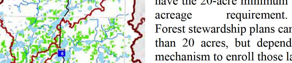
11 Managed Forest Lands Kathio S. Kathio Æ% 27 Bradbury South Harbor Onamia Onamia Æ% 18 East SideÆ% 47 Isle Æ% 27 Wahkon Isle Harbor Lewis Æ% 27 Æ% 47 TOWNSHIP PARCELS ACRES Bradbury 51 6,086 Dailey East Side Hayland Isle Harbor Kathio Lewis 25 2,241 Milaca 1 71 Milo 1 20 Mudgett Onamia Page 20 1,887 Princeton South Harbor TOTAL ,088 Dailey 169 Mudgett Page Hayland Legend U.S. Highway State Highway Waterbasin Milaca BorgholmBock Watercourse Æ% 23 Foreston Milaca SFIA Parcels Government Ownership Milo Pease Bogus Brook ± Greenbush Æ% 95 Princeton Princeton Miles Mille Lacs County Environmental Resources Date: 3/5/2018

12 LOCAL WATER MANAGEMENT PLAN ADVISORY - Subcommittee It is the mission of the Mille Lacs County Local Water Management Plan Advisory Committee to promote responsible stewardship of water resources through accountable use of land, forest and other natural assets by providing education, incentives, and collaboration with individuals, groups and government entities. OUTCOMES 1 3 PM Friday, March 2, 2018 WMAC Water Plan Update Subcommittee Monthly Planning Meeting Conf. Room B Purpose Statement Facilitate the Comprehensive Water Management Plan update work plan and action steps needed to ensure civic engagement and citizen input is received during the priority scoping process to achieve the best plan possible for the public good. 1) County Water Management Plan Update - Continued development of Outcomes & Actions Report on last meeting agreements: 1. Dillon will incorporate outcomes from group discussion into a new draft version of the logic model. 2. Dillon and Michele will work on drafting Outcomes for the Water Quantity goal under the Development impacts on surface water Objective. 3. Susan and Harmony will work on outreach Outcomes and Actions Decisions made:... Dillon will update the draft document 1. Make Civic Engagement a goal and repeat Outcomes and Actions identified under it for each Objective. 2. Another Objective was created to address Priority Concern #4 separately. Outcomes were drafted. 3. Need to review the old Water Plan and WRAPS to include any pertinent action steps... Susan will review both documents 2) BWSR Board PCSD presentation Thursday, March 8, 3:30PM St. Paul Michele and Susan will attend the BWSR Board meeting to answer questions about the Priority Concerns Scoping Document. Pending input from Jason Weinerman, the consensus to come prepared with some handouts/excerpts from the PCSD about the public input process used and input received. If a ppt is used it would be brief. 3) WMAC agenda items? Possible presentation by Al Heim on SFIA in ML County: What it is? What voluntary restrictions are placed on land and for how long?... Michele will invite Al Review/Input from the Committee on draft Objectives and Actions. Prepare materials for the mailing to be sent Friday March 9 th.... Susan/Dillon/Michele Possible presentation by TNC on the SAMS hydrologic model would be best done for the subcommittee before considering a WMAC presentation. 4) Next Meetings Regular WMAC meeting... Thursday, March 15 WMAC sub-committee meeting to review the BWSR Biennial Budget Request (BBR)... Friday, March 23 WMAC sub-committee meeting to review Objectives... Friday, April 6 Mille Lacs County Local Water Management Plan Advisory Committee Page 1
13 Mille Lacs County Priority Concerns (Identified by the Water Plan Advisory Committee 2017) PRIORITY CONCERNS Priority concerns, as defined in Minnesota Statute 103B.305, refers to the issues, resources, sub watersheds, or demographic areas identified as a priority by a water planning authority. The concerns identified as priorities within Mille Lacs County include: 1. Cumulative negative impacts of improper land management and continued development within the Rum River watershed. 2. Impaired or degraded waters in the Upper Rum River and West Branch of the Rum River intermediate watersheds. 3. Adverse impacts to water quality, infiltration, and flow, caused by land use conversion or development. 4. Adverse impacts of detrimental surface and sub-surface water management practices on existing and future development. 5. Lack of information and understanding regarding the quality and quantity of groundwater, and the resultant impacts on land management decisions.
14 A B C D E F G H GOALS 3.2 OBJECTIVE 3.2 OUTCOMES ACTIONS RESOURCES TIMELINE LGU HYDROLOGIC UNITS "The anticipated measurable result of the action or strategy" "Implementation strategies or actions that address the goal" Specific sampling (reach analysis) to determine sources of impairments identified in the WRAPS. Priority Concerns #1 - #3: Implementation Program "Staff and financial resources available or needed to carry out the actions" "When the action will start and be completed" "The local unit(s) of government delegated implementation responsibility" "The watersheds or groundwater units benefiting from the initiatives" Enhanced baseline water quality data will be available. Strategic stream monitoring program for impaired streams (trend data). Evaluate/inventory water treatment infrastructure. Identify stream reaches most susceptible to land use changes. Sample streams identified as most susceptible to land use changes. Mitigate the impacts of devleopment on surface water quality. Enhanced baseline water quality data will be analyzed and synthesized for civic engagement. Map enhanced baseline water quality data. Develop a fact sheet to illustrate the results of enhanced water quality data sampling efforts. Develop a guide for land-use decision makers based on enhanced baseline water quality data. Conduct education and outreach. Information will be available to assess the potential for water quality impacts from forest land conversion and associated land use changes. Conduct a land use conversion risk analysis utilizing the following information: land ownership, SFIA enrollment, forest composition, land use regulations. Complete a forest stewardship plan.
15 A B C D E F G H GOALS 3.2 OBJECTIVE 3.2 OUTCOMES ACTIONS RESOURCES TIMELINE LGU HYDROLOGIC UNITS "The anticipated measurable result of the action or strategy" use changes. "Implementation strategies or actions that address the goal" Priority Concerns #1 - #3: Implementation Program "Staff and financial resources available or needed to carry out the actions" "When the action will start and be completed" "The local unit(s) of government delegated implementation responsibility" "The watersheds or groundwater units benefiting from the initiatives" Development impacts on surface water. Implement civic engagement efforts. Individuals will understand their role in affecting surface water quality and quantity. Land Use Decision Makers will understand their role in affecting surface water quality and quantity. Identify individuals/groups that are impacted by the issue. Participate regularly with those impacted to identify their role in the solution. Identify land use decision makers that are impacted by the issue. Regularly meet with key land use decision makers to idenfity their role in the solution. SWCD FTE participation by groups (clubs, associations, civic groups, etc.) SWCD FTE MLC FTE participation by local government staff, elected officials, planning commissions, townships, cities, businesses, developers, etc. SWCD, MLC
16 A B C D E F G H GOALS 3.2 OBJECTIVE 3.2 OUTCOMES ACTIONS RESOURCES TIMELINE LGU HYDROLOGIC UNITS "The anticipated measurable result of the action or strategy" "Implementation strategies or actions that address the goal" Priority Concerns #1 - #3: Implementation Program "Staff and financial resources available or needed to carry out the actions" "When the action will start and be completed" "The local unit(s) of government delegated implementation responsibility" "The watersheds or groundwater units benefiting from the initiatives" Mitigate the impacts of devleopment on surface water quantity. Identified water quantity areas of concern and individual catchments to address quantity issues at an appropriate scale. Established threshold limits, individual and cumulative, on a sub and major watershed, and community basis. Evaluate/inventory stormwater infrastructure. Identify "end users" most susceptible to water quantity fluctuations and corresponding impacts. Identify areas of quantity concern on a HUC 12 basis. Map identified "end users" and areas of quantity concern on a HUC 12 basis. Identify catchments most susceptible to land use change, and the corresponding effects on water quantity. Establish threshold limits based on infrastructure, end users, and susceptibility to land use change. Develop a fact sheet to illustrate the results of water quantity assessment and threshold establishment. Develop a guide for land-use decision makers based on water quantity thresholds. Conduct education and outreach.
17 A B C D E F G H GOALS 3.2 OBJECTIVE 3.2 OUTCOMES ACTIONS RESOURCES TIMELINE LGU HYDROLOGIC UNITS "The anticipated measurable result of the action or strategy" "Implementation strategies or actions that address the goal" Development strategies for the implentation of agricultural drainage best management practices. Analyze riparian develpmetn practices. Priority Concerns #4: Implementation Program "Staff and financial resources available or needed to carry out the actions" "When the action will start and be completed" "The local unit(s) of government delegated implementation responsibility" "The watersheds or groundwater units benefiting from the initiatives" Water management. Develop mitigation practices/higher standards to mitigate detrimental riparian development practices. Review forestry management practices and engage partners in the responsible management of forested parcels. Surface and Sub- Surface Water Management Practices and Development. Mitigate the impacts of detrimental surface and subsurface water management practices on development. Stormwater management. Individuals will understand their role as it relates to water management practices. Land Use Decision Makers will understand their Complete a culvert inventory. Analyze road authority practices in the management of roadside stormwater. Develop best management practices for the effective management of roadside stormwater. Analyze and implement opportunities for peak water retention. Identify individuals/groups that are impacted by the issue. Participate regularly with those impacted to identify their role in the solution. Identify land use decision makers that are impacted by the issue. SWCD FTE participation by groups (clubs, associations, civic groups, etc.) SWCD FTE MLC FTE participation by local government staff, elected officials, planning
18 A B C D E F G H GOALS 3.2 OBJECTIVE 3.2 OUTCOMES ACTIONS RESOURCES TIMELINE LGU HYDROLOGIC UNITS "The anticipated measurable result of the action or strategy" role as it relates to water managemetn practices. "Implementation strategies or actions that address the goal" Regularly meet with key land use decision makers to idenfity their role in the solution. Priority Concerns #4: Implementation Program "Staff and financial resources available or needed to carry out the actions" commissions, townships, cities, businesses, developers, etc. "When the action will start and be completed" "The local unit(s) of government delegated implementation responsibility" SWCD, MLC "The watersheds or groundwater units benefiting from the initiatives"
19 A B C D E F G H GOALS 3.2 OBJECTIVE 3.2 OUTCOMES ACTIONS RESOURCES TIMELINE LGU HYDROLOGIC UNITS "The anticipated measurable result of the action or strategy" "Implementation strategies or actions that address the goal" Complete Geologic Atlas. Priority Concerns #5: Implementation Program "Staff and financial resources available or needed to carry out the actions" "When the action will start and be completed" "The local unit(s) of government delegated implementation responsibility" "The watersheds or groundwater units benefiting from the initiatives" Mitigate the impacts of groundwater quality on development. Groundwater quality information will be available. Groundwater quality data will be analyzed and sythesized for stakeholder consumption. Complete comprehensive nitrate sampling. Program and implement systematic testing for common groundwater contaminants: pesticides, arsenic, nitrates, etc. Develop a fact-sheet or other informational materials summarizing Geologic Atlas findings. Incorporate home sale testing and municipal well testing into database of groundwater quality data. Groundwater Impacts on development. Implement civic engagement efforts. Individuals will understand their role in affecting groundwater quality and quantity. Land Use Decision Makers will understand their role in affecting groundwater quality and quantity. Identify individuals/groups that are impacted by the issue. Participate regularly with those impacted to identify their role in the solution. Identify land use decision makers that are impacted by the issue. Regularly meet with key land use decision makers to idenfity their role in the solution. SWCD FTE participation by groups (clubs, associations, civic groups, etc.) SWCD FTE MLC FTE participation by local government staff, elected officials, planning commissions, townships, cities, businesses, developers, etc. SWCD, MLC
20 A B C D E F G H GOALS 3.2 OBJECTIVE 3.2 OUTCOMES ACTIONS RESOURCES TIMELINE LGU HYDROLOGIC UNITS "The anticipated measurable result of the action or strategy" "Implementation strategies or actions that address the goal" Priority Concerns #5: Implementation Program "Staff and financial resources available or needed to carry out the actions" "When the action will start and be completed" "The local unit(s) of government delegated implementation responsibility" "The watersheds or groundwater units benefiting from the initiatives" Groundwater areas of concern will be identified. Utilize groundwater data to identify areas with insufficient groundwater to support a varety of typical land uses. Rate and map areas with insufficient groundwater. Mitigate the impacts of groundwater quantity on development. Groundwater quantity will be incorporated in local land use regulations and conservation efforts. Complete Geologic Atlas. Revise land use regulations to promote sustainable developemnt in areas with limited groundwater resources (e.g. limiting development density to an appropriate level in propotion with available resources. Further conservation efforts to preserve sensitive areas from the detrimental effects of high-impact land use.


21


22
FY Biennial Budget Request Mille Lacs SWCD
 FY 18-19 Biennial Budget Request Mille Lacs SWCD Total Requested Biennial State Contribution: $1,075,818.00 BBR ID BBR16-0773 Total Leveraged Funds $200,000.00 Submitted Date 4/14/2016 Total Resource Project
C. Staffing Needs Approximately 150 staff days TSA #3 staff time will also be utilized.
 2017 Annual Plan I. Introduction The purpose of this annual plan is to detail work items that will be completed in 2017. The annual plan will provide a tool for SWCD staff and supervisors to evaluate program
Rice SWCD 2018 Annual Plan of Work
 Rice SWCD 2018 Annual Plan of Work Introduction The Rice Soil and Water Conservation District s Annual Plan is developed to provide guidance and direction to district staff and supervisors for the goals
Conservation Corps of Minnesota and Iowa Work Crew: Erosion Control Projects at Timber Bay Camp
 Conservation Corps of Minnesota and Iowa Work Crew: Erosion Control Projects at Timber Bay Camp Project Status: Initiated 8/31/17 Project approved: 4/17/18 Completed 6/8/18 Funding: CCMI Crew Josh, Austin
Shell Rock River Watershed: Water Plans
 Shell Rock River Watershed: Water Plans The Shell Rock River Watershed encompasses Freeborn County. Each county has developed a 10-year rotating comprehensive local water management plan (LWMP) in order
Crow Wing Soil and Water Conservation District Annual Plan
 Crow Wing Soil and Water Conservation District 2007 Annual Plan 1 I. INTRODUCTION The Crow Wing SWCD Supervisors and Staff with the aid of the U.S. Department of Agriculture, are developing this plan to
Environment and Natural Resources Trust Fund 2018 Request for Proposals (RFP)
") Environment and Natural Resources Trust Fund 2018 Request for Proposals (RFP) Project Title: Prioritize and Target North-Central Minnesota Lakes for Protection Category: G. Land Acquisition, Habitat and
Environment and Natural Resources Trust Fund 2018 Request for Proposals (RFP) Project Title: Prioritize and Target North-Central Minnesota Lakes for Protection Category: G. Land Acquisition, Habitat and
Water Governance Evaluation
 Water Governance Evaluation Streamline, strengthen and improve sustainable water management John Linc Stine MPCA Commissioner Suzanne Rhees Water Governance Evaluation Coordinator Clean Water Council November
Comprehensive Plan
 Comprehensive Plan 2008-2012 Approved April 16, 2008 South St. Louis SWCD Board of Supervisors I. Introduction A. Purpose The purpose of this Comprehensive Plan is to establish an action strategy for the
2011 Report. The purpose of this report is to briefly discuss items that were completed in 2011.
 2011 Report Narrative of the year s activities 1. Introduction The mission of the South St. Louis Soil and Water Conservation District is to provide technical, educational, and financial resources to land
One Watershed, One Plan Plan Content Requirements
 One Watershed, One Plan Plan Content Requirements From the Board of Water and Soil Resources, State of Minnesota Version: 2.00 Effective Date: 03/28/2018 Approval: Board Decision #18-14 Policy Statement
Isanti Soil and Water Conservation District Strategic Framing
 Isanti Soil and Water Conservation District Strategic Framing Completed August 18, 2015 Adopted by the Isanti SWCD Board September 15, 2015 Assisted by Jason Weinerman MN Board of Water and Soil Resources
DAKOTA COUNTY SOIL AND WATER CONSERVATION DISTRICT COMPREHENSIVE PLAN
 DAKOTA COUNTY SOIL AND WATER CONSERVATION DISTRICT COMPREHENSIVE PLAN 2011-2015 4100 220 th Street West, Suite 102 Farmington, MN 55024 651-480-7777 www.dakotacountyswcd.org I. INTRODUCTION A. Purpose
Soil & Water Conservation District
 Soil & Water Conservation District 215 1 st Avenue South, Long Prairie, MN 56347 Phone: 320-732-2644 Fax: 320-732-4803 TODD COUNTY SWCD BOARD WORK SESSION AGENDA Todd Soil and Water Conservation District
Porter County Soil & Water Conservation District Five Year Strategic Plan
 Porter County Soil & Water Conservation District Five Year Strategic Plan 2017-2021 This long range strategic plan has been developed to guide the Porter County Soil and Water Conservation District s programs
Our Vision of the Future
 INTRODUCTION Our Vision of the Future The function of the Grant Soil and Water Conservation District is to provide the general population of Grant County with the knowledge and ability needed to protect
Environment and Natural Resources Trust Fund (ENRTF) M.L Work Plan
 M.L Work Plan") Environment and Natural Resources Trust Fund (ENRTF) M.L. 2016 Work Plan Date of Report: May 29, 2016 Date of Next Status Update Report: 1/31/2017 Date of Work Plan Approval: June 7, 2016 Project Completion
Environment and Natural Resources Trust Fund (ENRTF) M.L. 2016 Work Plan Date of Report: May 29, 2016 Date of Next Status Update Report: 1/31/2017 Date of Work Plan Approval: June 7, 2016 Project Completion
January 1, 2017 to December 31, 2017
 BIG STONE SOIL & WATER CONSERVATION DISTRICT S ANNUAL PLAN OF WORK In Cooperation with Big Stone County Environmental Office, the Natural Resources Conservation Service, and Farm Services Agency January
MORRISON SOIL AND WATER CONSERVATION DISTRICT
 MORRISON SOIL AND WATER CONSERVATION DISTRICT 16776 Heron Road Little Falls, MN 56345 (320) 616-2479 www.morrisonswcd.org ANNUAL PLAN OF OPERATIONS January 1, 2014 to December 31, 2014 OBJECTIVE ONE: To
MORRISON SOIL AND WATER CONSERVATION DISTRICT
 MORRISON SOIL AND WATER CONSERVATION DISTRICT 16776 Heron Road Little Falls, MN 56345 (320) 616-2479 www.morrisonswcd.org ANNUAL PLAN OF OPERATIONS January 1, 2014 to December 31, 2015 OBJECTIVE ONE: To
Cannon River One Watershed, One Plan. POLICY COMMITTEE MEETING January 10, 2018 Rice County Government Center Faribault, MN
 Cannon River One, One Plan POLICY COMMITTEE MEETING January 10, 2018 Rice County Government Center Faribault, MN TASK Task 1. Aggregate Existing Physical & Spatial Data 1A. Create project maps 1B. Meeting
Board of Managers Meeting - Wednesday July 19 th, 2017
 Board of Managers Meeting - Wednesday July 19 th, 2017 Annual Tour at 6:00 p.m. Miesville Ravine Park 27970 Orlando Trail Cannon Falls, MN 55009 Regular Meeting at 7:00 p.m. Douglas Town Hall 12409 240
DRAFT Budget and Outcomes Committee FY18-19 Clean Water Fund recommendations (July 8, 2016)
") Name FY18-19 Description s 20 BWSR Targeted Wellhead/Drinking Water Protection For permanent conservation easements on wellhead protection areas under Minnesota Statutes, section 103F.515, subdivision
Name FY18-19 Description s 20 BWSR Targeted Wellhead/Drinking Water Protection For permanent conservation easements on wellhead protection areas under Minnesota Statutes, section 103F.515, subdivision
BWSR PROGRAMS THAT ADDRESS NUTRIENT LOSS
 BWSR PROGRAMS THAT ADDRESS NUTRIENT LOSS DRAINAGE LAW BUFFER PROGRAM CREP - GRANT PROGRAMS - PROJECTS 2017 MVTL Agronomy Update Meeting New Ulm, MN February 28, 2017 Jill Sackett Eberhart ~ BWSR Board
Otter Tail County Local Water Management Plan August 31, Amended 2014
 Otter Tail County Local Water Management Plan August 31, 2009-2019 Amended 2014 Official Comment Period February 21 March 21 Comments and Plans received from the following: MN DNR MDA BWSR Douglas County
MORRISON SOIL AND WATER CONSERVATION DISTRICT
 MORRISON SOIL AND WATER CONSERVATION DISTRICT 16776 Heron Road Little Falls, MN 56345 (320) 616-2479 www.morrisonswcd.org ANNUAL PLAN OF OPERATIONS January 1, 2016 to December 31, 2016 OBJECTIVE ONE: To
Annual Plan of Work 2009
 Annual Plan of Work 2009 Our mission is to assist the citizens of Faribault County in improving water quality and reducing soil erosion, establishing wildlife habitat, and promoting information and education
Water Plans. Water Plans: Houston County LWMP amended 2012 Winona County LWMP
 Mississippi River La Crescent Watershed: Water Plans The Mississippi River La Crescent Watershed encompasses Houston and Winona Counties. Each county has developed a 10-year rotating comprehensive local
WATERSHED MANAGEMENT IN MINNESOTA. GOVERNANCE, PLANNING, AND FUNDING June 19, 2018 Cedar Rapids, Iowa
 WATERSHED MANAGEMENT IN MINNESOTA GOVERNANCE, PLANNING, AND FUNDING June 19, 2018 Cedar Rapids, Iowa GOVERNANCE - WD 1955 Watershed Act (MN Statute 103D) Local petition to form VOLUNTARY watershed district
SHERBURNE SOIL & WATER CONSERVATION DISTRICT ANNUAL PLAN OF WORK
 SHERBURNE SOIL & WATER CONSERVATION DISTRICT 2014 ANNUAL PLAN OF WORK Table of Contents I. Introduction... 3 II. Annual Objectives... 3 A. Protect and/or Improve Water Quality and Quantity... 3 B. Reduce
Data Collection and Monitoring
 One Watershed, One Plan Data Collection and Monitoring Supporting information for Section III.F.5 of the 1W1P Plan Content Requirements This document discusses considerations for local governments in designing
Thief River One Watershed One Plan Prioritization Matrix Prioritization of Issues
 Thief River One Watershed One Plan Prioritization Matrix Prioritization of Issues The Prioritization Matrix is a categorized table that lists the issues that were compiled for the Thief River watershed,
SHERBURNE SOIL & WATER CONSERVATION DISTRICT ANNUAL PLAN OF WORK
 SHERBURNE SOIL & WATER CONSERVATION DISTRICT 2016 ANNUAL PLAN OF WORK Table of Contents I. Introduction... 3 II. Annual Objectives... 3 A. Protect and/or Improve Water Quality and Quantity... 3 B. Reduce
MGWA Spring Conference April 19, 2012
 Lanya Ross, Metropolitan Council for the Interagency Groundwater/Drinking Water Team MGWA Spring Conference April 19, 2012 to protect drinking water sources to protect, enhance, and restore wetlands, prairies,
Long Prairie River Watershed Restoration and Protection Strategies (WRAPS) Report Summary
 Report Summary") Long Prairie River Watershed Restoration and Protection Strategies (WRAPS) Report Summary Minnesota has adopted a watershed approach to address the state s 80 major watersheds (denoted by 8-digit hydrologic
Long Prairie River Watershed Restoration and Protection Strategies (WRAPS) Report Summary Minnesota has adopted a watershed approach to address the state s 80 major watersheds (denoted by 8-digit hydrologic
Plan of Work Waseca Soil and Water Conservation District
 Plan of Work - 2018 Waseca Soil and Water Conservation District Adopted by Board motion on 1/11/2018 Introduction The SWCD is the local unit of government that provides assistance to citizens who are interested
awetlands aprairie aforests ahabitat for Fish, Game & Wildlife
 Rec. H1 priority land habitats pp. 63-67 Priority areas identified in integrated mapping assessing critical land habitat and threats to habitat pp.33-63 o Mapping is scalable for use in localized areas
FARIBAULT COUNTY SWCD 2008 Annual Report
 1 FARIBAULT COUNTY SWCD 2008 Annual Report Throughout 2008, the Faribault County Soil and Water Conservation District, along with the Planning and Zoning Department, had many opportunities to assist the
ANNUAL PLAN MURRAY SOIL AND WATER CONSERVATION DISTRICT. Slayton, MN. January 1, December 31, 2018
 2018 ANNUAL PLAN OF MURRAY SOIL AND WATER CONSERVATION DISTRICT Slayton, MN January 1, 2018- December 31, 2018 1 TABLE OF CONTENTS I. INTRODUCTION II. OBJECTIVES A. Annual Objectives B. Actions C. Staffing
The Purpose and Scope of this Guidance
 Introduction The nation s aquatic resources are among its most valuable assets. While environmental protection programs in the United States have successfully improved water quality during the past 25
Agricultural/Rural Riparian Buffer Analysis
 Agricultural/Rural Riparian Buffer Analysis December 2014 Executive Summary The Agricultural/Rural Riparian Buffer Analysis was developed from a 2014 analysis of current requirements for the riparian areas
Dakota County Soil and Water Conservation District. Strategic Plan
 Dakota County Soil and Water Conservation District Strategic Plan Adopted September 6, 2012 Goals and Objectives In March of 2012 the Dakota County Soil and Water Conservation District (District) Board
City of Fairmont Storm Water Pollution Prevention Plan Annual Public Meeting. June 11, 2018
 City of Fairmont Storm Water Pollution Prevention Plan Annual Public Meeting June 11, 2018 Why is Water Quality Important? Water has always been important to Minnesota and is a key part of our history,
3D WETLAND MANAGEMENT
 3D WETLAND MANAGEMENT 1. ISSUE Wetlands are one of the most productive ecosystems. They provide biological and chemical functions to the landscape that serve the watershed including the moderation of nutrient
RESOURCE DIRECTORY. Contents
 RESOURCE DIRECTORY A Guide to Acronyms...3 General Resource Management Information via the Web...4 Natural Resource Management and Stewardship: Information and Educational Materials...4 Developing Forest
CHAPTER 4 WATERSHED PLAN GOALS & OBJECTIVES
 4.0 Introduction CHAPTER 4 WATERSHED PLAN GOALS & OBJECTIVES After the watershed analysis had been completed, the next step in the planning process followed by the group was to come up with goals and objectives
EAST TORRANCE SOIL AND WATER CONSERVATION DISTRICT. LONG RANGE PLAN July 1, 2009 June 30, 2019
 EAST TORRANCE SOIL AND WATER CONSERVATION DISTRICT LONG RANGE PLAN July 1, 2009 June 30, 2019 INTRODUCTION The East Torrance Soil and Water Conservation District covers 1,142,028 acres of land in Torrance
Memo. Job Posting: To: David Unmacht, Springsted Inc. From: Jeff Spartz, Interim District Administrator. Date: October 20, 2014
 Memo To: David Unmacht, Springsted Inc. From: Jeff Spartz, Interim District Administrator Date: October 20, 2014 Re: District Administrator Position Profile On October 10, 2014 the District Administrator
Minutes of the Board of Supervisors Regular Board Meeting held January 11, 2016.
 Ramsey Conservation District Approved February 8, 2016 1425 Paul Kirkwold Drive Highway 96 & Hamline Avenue Arden Hills, MN 55112 Telephone 651-266-7270 Fax 651-266-7276 www.ramseyconservation.org Minutes
The Reinvest in Minnesota Land Retirement Program
 The Reinvest in Minnesota Land Retirement Program Sara Aplikowski Introduction The Reinvest in Minnesota (RIM) Reserve program seeks to retire marginal lands from agricultural production and to restore
Mille Lacs County Local Water Resource Management Plan
 FINAL 2012 mid-plan Update Local Water Resource Management Plan January 1, 2006 December 31, 2016 2012 Amendments Prepared by the Mille Lacs Soil and Water Conservation District and the Local Water Planning
MISSION STATEMENT EAST OTTER TAIL SOIL AND WATER CONSERVATION DISTRICT
 MISSION STATEMENT OF EAST OTTER TAIL SOIL AND WATER CONSERVATION DISTRICT It shall be the mission of the Soil and Water Conservation District to conserve and protect our soil and water resources that were
Staff. Brenda Smythe - Manager Kelly Smith - Technician. Contract Staff. Jerika Lujan - College Intern Jim Frost Grass Drill Operator
 2012-2013 REPORT The Edgewood Soil & Water Conservation District covers 487,535 acres in portions of southern Santa Fe, eastern Bernalillo, and northern Torrance counties. This consists of approximately
One Watershed, One Plan
 One Watershed, One Plan An evolution of water planning in Minnesota 2014 The Vision The One Watershed, One Plan vision is to align local water planning on major watershed boundaries with state strategies
MN CREP 2019 Winter Updates
 MN CREP 2019 Winter Updates 1 Signage Importance All RIM easements are required to be properly signed If Farm Bill Assistance Staff worked on an easement, need to post a sign w/ Legacy Logo on the site
DES PLAINES RIVER WATERSHED WORKGROUP DRAFT WORKPLAN /18
 DES PLAINES RIVER WATERSHED WORKGROUP DRAFT WORKPLAN 2017-2021 1/18 1 DRWW: A BRIEF HISTORY Lakes and streams within the Des Plaines River watershed have been identified by the Illinois Environmental Protection
Reservoir age, increasing human population,
 B-6249 02/12 Eagle Mountain Watershed Management Brent Clayton, Justin Mechell, David Waidler and Clint Wolfe* Reservoir age, increasing human population, and changing land uses have prompted the development
ANNUAL PLAN OF WORK AND BUDGET WATONWAN COUNTY SOIL AND WATER CONSERVATION DISTRICT
 ANNUAL PLAN OF WORK AND BUDGET 2014 WATONWAN COUNTY SOIL AND WATER CONSERVATION DISTRICT WATONWAN COUNTY LAND MANAGEMENT/SOIL AND WATER CONSERVATION DISTRICT 108 Eighth Street South, Suite 2, St. James,
Conservation News. Erickson named Outstanding Conservationist. October/November SWCD Board of Supervisors
 Conservation News October/November 2017 SWCD Board of Supervisors Erickson named Outstanding Conservationist Dennis Feuchtenberger Greg Fynboh Troy Goodnough Jim Krosch Dave Lonergan, Chair SWCD Staff
Notice of Intent for New or Renewal of General Permit for Discharges from Small MS4s Preamble
 Preamble PREAMBLE to NOTICE OF INTENT FOR NEW OR RENEWAL OF GENERAL PERMIT FOR DISCHARGES FROM SMALL MUNICIPAL SEPARATE STORM SEWER SYSTEMS - MS4S describing LAKE COUNTY S COUNTYWIDE APPROACH TO STORMWATER
ENVIRONMENT & NATURAL RESOURCES
 ENVIRONMENT & NATURAL RESOURCES Policy Committee Thursday, September 13, 2018 1:00-4:00 PM Friday, September 14, 2018 8:30-11:30 AM Arrowwood Resort and Conference Center Alexandria, MN TENTATIVE AGENDA
Wetland Regulatory Aspects of Plant Community Mapping
 Wetland Regulatory Aspects of Plant Community Mapping Major Topics: Delineation and Classification Wetland Implications (in-kind) Monitoring of Wetland Sites Delineating Plant Community Types t new concept
215 1 st Avenue South, STE 104, Long Prairie, MN Phone:
 Soil & Water Conservation District 215 1 st Avenue South, STE 104, Long Prairie, MN 56347 Phone: 320-732-2644 TODD COUNTY SWCD BOARD WORK SESSION AGENDA Todd Soil and Water Conservation District Board
Cannon River Watershed Plan Development: Work Plan
 Cannon River Watershed Plan Development: Work Plan This Work Plan outlines tasks and a budget for the development of a watershed-based plan consistent with the One Watershed, One Plan vision and program
One Watershed, One Plan Operating Procedures
 One Watershed, One Plan Operating Procedures From the Board of Water and Soil Resources, State of Minnesota Version: 2.00 Effective Date: 03/28/2018 Approval: Board Decision #18-14 Policy Statement These
Protect & Conserve. Conserving Natural Resources For Our Future. In this issue: SWCD Funding Update
 Protect & Conserve February, 2016 Conserving Natural Resources For Our Future In this issue: Legislative Day Information NLR Roadshow Information How Do SWCDs Assist State & Federal Agencies? SWCD Services
Annual Report 2016 July 1, 2015 June 30, 2016
 Wake Soil and Water Conservation District Wake County Soil and Water Conservation Department Annual Report 2016 July 1, 2015 June 30, 2016 Protecting Wake County s Natural Resources 2 Executive Summary
Updates and items for discussion
 Budget and Outcomes Committee Updates and items for discussion June 18, 2012 Role of the Clean Water Council The Clean Water Council was created to advise on the administration and implementation of the
Environment and Natural Resources Trust Fund 2014 Request for Proposals (RFP)
") Environment and Natural Resources Trust Fund 2014 Request for Proposals (RFP) Project Title: Demonstration Water Quality Protection Practices on Zumbro River ENRTF ID: 089C Category: C. Environmental Education
Environment and Natural Resources Trust Fund 2014 Request for Proposals (RFP) Project Title: Demonstration Water Quality Protection Practices on Zumbro River ENRTF ID: 089C Category: C. Environmental Education
City of Fairmont Storm Water Pollution Prevention Plan (SWPPP) January 23, 2017
 January 23, 2017") City of Fairmont Storm Water Pollution Prevention Plan (SWPPP) January 23, 2017 Why is Water Quality Important? Water has always been important to Minnesota and is a key part of our history, culture, economy
City of Fairmont Storm Water Pollution Prevention Plan (SWPPP) January 23, 2017 Why is Water Quality Important? Water has always been important to Minnesota and is a key part of our history, culture, economy
2014 Whatcom County Stormwater Management Program
 2014 2014 Whatcom County Stormwater Management Program A component of the Western Washington Phase II Municipal Stormwater Permit Whatcom County Public Works Department Stormwater Division THIS PAGE INTENTIONALLY
Lisa Prcin Watershed Coordinator Texas AgriLife Research at Blackland Research & Extension Center
 Lisa Prcin Watershed Coordinator Texas AgriLife Research at Blackland Research & Extension Center Approved replacement of previous SC member Danny Stephens (OMI; WWTF representative) with Lance Carlson
Mud Lake Lakeshed Assessment
 Mud Lake Lakeshed Assessment The lakeshed vitals table identifies where to focus organizational and management efforts for each lake. Criteria were developed using limnological concepts to determine the
Public Notice ISSUED: 11 February 2019 EXPIRES: 13 March 2019
 SPONSOR: Minnesota Board of Water and Soil Resources Public Notice ISSUED: 11 February 2019 EXPIRES: 13 March 2019 REFER TO: MVP-2019-0122-JTB SECTION: 404 - Clean Water Act 1. WETLAND COMPENSATORY MITIGATION
PART VI MINNESOTA COASTAL NONPOINT SOURCE PROGRAM
 PART VI MINNESOTA COASTAL NONPOINT SOURCE PROGRAM A. SUMMARY OF DEVELOPMENT AND STATUS OF STATE NPS PROGRAMS 1. Background A major effort to combat water pollution began with the passage of the federal
Appendix A PRIORITY CONCERNS SCOPING DOCUMENT FOR GRANT COUNTY LOCAL WATER MANAGEMENT PLAN
 Appendix A PRIORITY CONCERNS SCOPING DOCUMENT FOR GRANT COUNTY LOCAL WATER MANAGEMENT PLAN Appendix A Introduction: The population of Grant County is listed at 6,289 (2000 Census). The trend of population
CBP Implementation Plan
 York County Conservation District CBP Implementation Plan March 2014 York County Conservation District 118 Pleasant Acres Road York, PA 17402 Phone: (717) 840-7430 www.yorkccd.org 1 Table of Contents Introduction
S5.C.1 Public Education and Outreach
 City of Ferndale 2018 Stormwater Management Program This document is formatted as a response to specific special conditions within the Western Washington Phase II Municipal Stormwater Permit (Permit) that
Actions Target Date Individuals Responsible 1. Adopt an annual budget of revenues and expenditures July 7, 2017 SWCD Board and Staff
 Conservation District Priority #1: Maintain District Operations Goals: Achieve a standard of excellence as a Soil & Water Conservation District. Objectives: To function appropriately, efficiently, and
City of Tacoma Stormwater Management Program Assessment. Attachment B3
 City of Tacoma Stormwater Management Program Assessment Attachment B3 Attachment B3. City of Tacoma Stormwater Management Program Assessment The following discussion includes an assessment of the appropriateness
2016 Annual Plan of Operations
 Becker Soil & Water Conservation District 2016 Annual Plan of Operations Staff: Rear L-R: Karl Koenig, Phil Doll, Ray Hummel, Peter Mead, Ed Musielewicz, Jeff Norby; Front L-R: Jennifer Wentz, Marsha Watland,
Notice of Intent for New or Renewal of General Permit for Discharges from Small MS4s Preamble
 Preamble PREAMBLE to NOTICE OF INTENT FOR NEW OR RENEWAL OF GENERAL PERMIT FOR DISCHARGES FROM SMALL MUNICIPAL SEPARATE STORM SEWER SYSTEMS - MS4S describing LAKE COUNTY S COUNTYWIDE APPROACH TO STORMWATER
INVENTORY CHISAGO COUNTY PUBLIC DITCH SYSTEM
 INVENTORY CHISAGO COUNTY PUBLIC DITCH SYSTEM Accepted by the Chisago County Board of Commissioners on November 16, 2016 Inventory Chisago County Chapter 103E Drainage Ditches for Water Quality Degradation
2016 Adams County LWCD Plan of Operations
 2016 Adams County LWCD Plan of Operations I. County Owned Dams a. Goal: Inspect, Operate and Maintain dams as specified in the I.O.M. Plan to meet State laws/standards. Action: Update I.O.M. Plan and Emergency
2019 Annual Plan of Operations. Becker Soil & Water Conservation District MISSION STATEMENT:
 Becker Soil & Water Conservation District 2019 Annual Plan of Operations MISSION STATEMENT: The mission of the Becker Soil and Water Conservation District is to provide leadership in the conservation of
Table G - 7. Mitigation Actions Identified for Implementation by the City of Eyota ( ) (From Olmsted County Master Mitigation Action Chart)
 (From Olmsted County Master Mitigation Action Chart)") Multi-Hazard Plan, 2017 Table G - 7. Actions Identified for by the City of () (From Master Action Chart) City of Action Comments on 1 All- Hazards Preparedness & Response Support Identify and map locations
Multi-Hazard Plan, 2017 Table G - 7. Actions Identified for by the City of () (From Master Action Chart) City of Action Comments on 1 All- Hazards Preparedness & Response Support Identify and map locations
BCMWC 2015 Watershed Management Plan. Section 5 Implementation
 BCMWC 2015 Watershed Management Plan Section 5 Implementation Contents 5.0 Implementation... 5-1 5.1 Responsibilities... 5-1 5.1.1 BCWMC Responsibilities... 5-1 5.1.1.1 Review of Improvements and Developments...
Efficient, Effective, Responsive Update on Dakota County Groundwater Plan Development
 Update on Dakota County Groundwater Plan Development Valerie A. Grover Groundwater Protection Unit Environmental Resources Department Physical Development Division 12 February 2019 Overview Groundwater
Norman County s Priority Concerns Scoping Document
 Norman County s Priority Concerns Scoping Document a The Priority Concerns Scoping Document of the Norman County Comprehensive Local Water Management Plan was developed in accordance with the changes to
Root River One Watershed, One Plan Request for Proposals Proposals DUE: Wednesday, December 3, 2014, 4:00 PM
 Root River One Watershed, One Plan Request for Proposals Proposals DUE: Wednesday, December 3, 2014, 4:00 PM The Root River Planning Area (which includes the Minnesota portion of the Upper Iowa River Watershed
Project Activity Description Water Plan Category Primary Activity Resource of Concern Priority. known)
") Board of Water and Soil s Water of Concern Targeting Projects and Activities (A) (B) (C) (D) (E) (F) (G) (H) (I) (J) (K) Conventional Subwatershed: 12- Water Quality Water Quality Scale of Activity Watershed:
Board of Water and Soil s Water of Concern Targeting Projects and Activities (A) (B) (C) (D) (E) (F) (G) (H) (I) (J) (K) Conventional Subwatershed: 12- Water Quality Water Quality Scale of Activity Watershed:
Hood River Watershed Group to sustain and improve the Hood River watershed through education, cooperation, and stewardship
 You are living in a watershed A watershed is the land area that drains to a particular lake, stream, or river. The Hood River watershed covers 339 square miles between Mt. Hood and the Columbia River.
COST SHARE AND TECHNICAL ASSISTANCE PROGRAMS FOR IMPLEMENTING BEST MANAGEMENT PRACTICES TO IMPROVE WATER QUALITY
 SCS 2010 12 COST SHARE AND TECHNICAL ASSISTANCE PROGRAMS FOR IMPLEMENTING BEST MANAGEMENT PRACTICES TO IMPROVE WATER QUALITY Jennifer L. Peterson, Program Specialist, Water Quality Larry A. Redmon, Professor
Regional Watershed Planning. Calumet Summit 2010: A Call to Connect Calumet Conference Center April 27, 2010
 Regional Watershed Planning Calumet Summit 2010: A Call to Connect Calumet Conference Center April 27, 2010 Basins The Calumet Region Watershed Communities Land Cover- 2006 Impervious Cover 303d Listed
Level II Performance Review
 Level Performance Review Black Dog Watershed Management Organization Local Government Unit Review Final Report July 31, 2017 Minnesota Board of Water and Soil Resources 520 Lafayette Road North St. Paul,
Mississippi River Winona Watershed: Water Plans
 Mississippi River Winona Watershed: Water Plans The Mississippi River Winona Watershed encompasses Olmsted, Wabasha, and Winona Counties. Each county has developed a 10-year rotating comprehensive local
COLLABORATION TOOLKIT
 COLLABORATION TOOLKIT PROTECTING DRINKING WATER SOURCES THROUGH AGRICULTURAL CONSERVATION PRACTICES Are you interested in getting more agricultural conservation practices on the ground to help protect
11. Prioritizing Farmlands for Future Protection
 11. Prioritizing Farmlands for Future Protection Identification of Important Farmlands in Putnam County I n order to implement this Plan successfully, Putnam County decision-makers will have to take advantage
Roots for Rivers. An Introduction to Floodplain Restoration & Steps For Implementing A Reforestation Project In Your Watershed
 Roots for Rivers An Introduction to Floodplain Restoration & Steps For Implementing A Reforestation Project In Your Watershed Kimber Ray Resource Service Coordinator The Watershed Institute 609-737-3735