Addendum No. 7 to the EIR
|
|
|
- Ross Lynch
- 5 years ago
- Views:
Transcription


1

2

3 Addendum No. 7 to the EIR San Bernardino County Transportation Authority Redlands Passenger Rail Project SCH No January 30, 2019
4 This page is intentionally blank.
5 Contents 1 Purpose and Background Applicability and Use of an Addendum Format of This Addendum Summary of Findings Lead Agency and Discretionary Approvals Description of Refined Project Introduction Project Location Description of Refined Project Status of Currently Approved Project Environmental Analysis Checklist Mitigation Measures Tables Table 1. Environmental Analysis Checklist Summary... 6 Table 2. Aesthetics... 8 Table 3. Agricultural Resources... 9 Table 4. Air Quality Table 5. Biological Resources Table 6. Cultural Resources Table 7. Geology and Soils Table 8. Greenhouse Gas Emissions Table 9. Hazards and Hazardous Materials Table 10. Hydrology and Water Quality Table 11. Land Use and Planning Table 12. Mineral Resources Table 13. Noise Table 14. Population and Housing Table 15. Public Services Table 16. Recreation Table 17. Transportation/Traffic Table 18. Utilities and Service Systems Table 19. Mandatory Findings i January 30, 2019
6 Attachments Attachment A. Figures Attachment B. Biological Resources Letter (Revised) Attachment C. Cultural Resources Letter (Revised) Attachment D. HEC-RAS Results ii January 30, 2019
7 1 Purpose and Background On March 4, 2015, the San Bernardino Associated Governments (now referred to as the San Bernardino County Transportation Authority [SBCTA]) certified the Final Environmental Impact Report (EIR) for the Redlands Passenger Rail Project (RPRP or Project) (State Clearinghouse No ). The approved Project will provide passenger rail operations along an approximately 9-mile corridor extending east from the City of San Bernardino to the City of Redlands. As approved, the Project will include local and express train service via five station stops; two in the City of San Bernardino; and three in the City of Redlands. Following additional coordination with local stakeholders, including the San Bernardino County Flood Control District (District), and engineering design for the approved Project, SBCTA is proposing a new drainage connection at Twin Creek; approximately 1,500 feet south of Central Avenue in the City of San Bernardino, California. As previously described in Section of the EIR, SBCTA contemplated drainage improvements at multiple locations along the railroad corridor, including reconstruction of existing culverts and the placement of new drainage facilities. In general, the proposed drainage connection would be consistent with this previous description. SBCTA approved Addendum No. 3 to the EIR in September 2017 for the approved Project (State Clearinghouse No ) to address the potential environmental impacts associated with a new drainage connection to Twin Creek. Since SBCTA s approval, new development has been approved by the City of San Bernardino between SBCTA s right-of-way and Twin Creek. In response, SBCTA has revised the proposed side drain design and intervening conveyance infrastructure to integrate with drainage infrastructure constructed as part of the new development. This addendum is prepared in accordance with the California Environmental Quality Act (CEQA) (Public Resources Code 21000, et. seq.) and the CEQA Guidelines (California Administrative Code, Title 14, 15000, et. seq.). Addendum No. 3, adopted by SBCTA in September of 2017 and the project s adopted mitigation monitoring and reporting program (MMRP) are incorporated by reference. 1.1 Applicability and Use of an Addendum SBCTA s intent through preparation of this addendum is to demonstrate whether the previously adopted CEQA document (i.e., Final EIR and Addendum), including mitigation measures, are still both adequate and valid for the refined Project. Pursuant to Public Resources Code Section and the CEQA Guidelines, Sections through 15164, SBCTA as the lead agency is required to conduct a fact-based evaluation of proposed changes to a project to determine whether supplemental environmental documentation is required. CEQA Guidelines, Sections 15162(a), states that when an EIR is certified for a project, no Subsequent or Supplemental EIR shall be prepared for that project unless the lead agency determines that one of the conditions described in Section 15162(a) has occurred. 1 January 30, 2019
8 Based on the analysis set forth in this addendum, SBCTA has concluded that the refined Project does not trigger any of these circumstances, and that an addendum continues to be the appropriate form of documentation to comply with CEQA. 1.2 Format of This Addendum The previously certified EIR serves as the initial environmental compliance document for the approved Project, and this addendum provides additional clarification and information about the refined Project. This addendum should be read together with the full text of the previously certified EIR (2015) and previously approved Addendum No. 3 (2017). All mitigation measures applicable from the EIR would be applicable to the refined Project and, therefore, are incorporated by reference into this addendum. This addendum relies on the use of an Environmental Checklist Form (Checklist), as suggested in Section 15063(d)(3) of the CEQA Guidelines. 1.3 Summary of Findings Based upon the Checklist prepared for the refined Project and supporting responses (Section 3), implementation of the refined Project would not result in substantial changes requiring major revisions to the EIR. Further, the refined Project would not result in any environmental impacts that have not already been addressed in the EIR, and no new mitigation measures are required for the refined Project. Since only minor additions and clarifications are required to the EIR, and none of the conditions described in Public Resources Code Section or CEQA Guideline requiring preparation of a subsequent EIR or negative declaration have occurred, SBCTA finds that the preparation of an addendum to the EIR is appropriate and consistent with Public Resources Code Section and CEQA Guidelines section Lead Agency and Discretionary Approvals This addendum, as revised, and the previously adopted EIR are intended to serve as the environmental documentation for the design refinements being proposed under the refined Project. SBCTA is the lead agency under CEQA and maintains authority to approve the addendum. 2 January 30, 2019
9 2 Description of Refined Project 2.1 Introduction The approved Project will facilitate passenger rail operations along an approximately 9-mile corridor extending east from the City of San Bernardino to the City of Redlands. The approved Project will include both local and express train service. Local service would occur via five station stops: E Street and Tippecanoe Avenue 1 located in the City of San Bernardino; and New York Street, Orange Street (Downtown Redlands) and University Street (University of Redlands) located in the City of Redlands. Metrolink express service would be limited to downtown Redlands and E Street. Components approved as part of the Project include replacement of the existing railroad tracks and ties, reconstruction or rehabilitation of existing bridge structures, and construction of station platforms and train layover facility. The EIR also analyzed auxiliary improvements such as parking, at-grade roadway crossings, pedestrian access, and new and relocated utilities, including water, sewer, storm drain, power, gas, fiber optic, and telephone lines. 2.2 Project Location The refined Project encompasses the same general Study Area as described for the approved Project in Section 2.3, which extends along existing railroad right-of-way (ROW) owned by SBCTA between the cities of San Bernardino and Redlands, San Bernardino County, California (see Attachment A, Figure 1). The proposed refinement to the approved Project would be constructed in the south-central portion of San Bernardino, south of Central Avenue, north of Orange Show Road, and west of Waterman Avenue. The proposed drainage connection would extend from an existing culvert in SBCTA s existing right-of-way (ROW) at mile post (MP) on the east to the Twin Creek Channel on the west. 2.3 Description of Refined Project SBCTA is proposing the replacement of an existing wooden box culvert at MP in SBCTA s ROW with a new reinforced concrete box (RCB) culvert as part of the approved Project s final design. Historically and as documented in the Section 3.8 and Appendix J1, Existing Drainage Conditions Memo of the Final EIR, drainage runoff along the corridor from MP 59 to 59.5 flows east to west (and southwest) and towards Twin Creek. More locally and as illustrated in Figure 2 of Attachment A, runoff from an approximately 26.5-acre drainage area is funneled west through the existing culvert and towards Twin 1 SBCTA has considered the environmental effects of relocating the station stop at Waterman Avenue, as proposed in the Final EIR, to Tippecanoe Avenue. Addendum #1 to the EIR provides an assessment of the station relocation to Tippecanoe Avenue, as considered as part of the Preferred Alterative in the EIR. 2 MP 2.63, as described previously in the Final EIR and Addendum, refers to the Redlands Subdivision mileposts. Metrolink has since assumed maintenance of way responsibility and has integrated the project corridor into Metrolink s San Gabriel Subdivision. MP is the integrated milepost reference (previously MP 2.63). 3 January 30, 2019
10 Creek. Based on a reconnaissance of the railroad (and culvert) during the approved Project s final design, the existing culvert was observed to be partially obstructed and in need of maintenance. The replacement of the existing culvert was a component of the approved Project that was contemplated and considered as part of the Final EIR. Following more detailed drainage analysis during the approved Project s final design, SBCTA has determined that replacement of the existing culvert will require corresponding drainage improvements to the west of SBCTA s ROW in order to maintain and improve the functional hydraulic grade between the railroad and Twin Creek. SBCTA had previously approved a design for the Twin Creek side drain connection (Figure 3 in Attachment A). Since SBCTA s approval of the refined Project, the City of San Bernardino has approved a new development between SBCTA s right-of-way and Twin Creek. This new development would interfere with the planned drainage infrastructure connecting SBCTA s RCB to a new side drain at Twin Creek, thus requiring the refinements described in Addendum 7. Figure 4 in Attachment A, illustrates the updated project footprint for the proposed culvert replacement (DS-8), supporting drainage interconnection (drainage system designed by others), and side-drain connection at Twin Creek (DS-9A). Each of these improvements is discussed in more detail below. Culvert Replacement (DS-8): SBCTA is proposing the replacement of an existing, wooden-box culvert with a new, 3-foot by 6-foot RCB that will extend approximately 28 linear feet (LF) at a slope of (to the west). The RCB would feed into a new storm drain system constructed as part of a new commercial development. The new underground storm drain system would cross South Washington Avenue connecting the culvert replacement with a junction structure (see Figure 4 in Attachment A) before converging with Twin Creek. Side-Drain Connection (DS-9A): SBCTA is proposing the installation of a new sidedrain connection at the western end of the storm drain system contemplated for the Washington Commerce Center East and West projects prior to the confluence with Twin Creek. The storm drain system would be connected to the proposed side-drain connection through three, 36 inch reinforced concrete pipes (RCP). The RCPs would extend linear feet (LF) underneath an access road located on the eastern bank of Twin Creek at a slope of The RCPs would discharge into the Twin Creek Channel at a 45 degree angle downstream. A new headwall with wingwalls would be constructed immediately after the RCP. One-fourth ton concreted rock slope protection would be installed at the outlet of the RCP and embedded into the channel slope to minimize the potential for scour. The limits of grading would extend approximately 47 linear feet after the RSP. Twin Creek is an Army Corps of Engineers (USACE) constructed facility, which is maintained and operated by the San Bernardino County Flood Control District. As a result, the proposed side drain connection is subject to the USACE s authorization under the Rivers and Harbors Act. 4 January 30, 2019
11 2.4 Status of Currently Approved Project SBCTA has completed the 100 percent plans and specifications for the approved Project. Construction of the approved Project is phased into four major construction contracts: (1) E Street Demolition; (2 and 3) Early Utilities in San Bernardino and Redlands; (4) and Mainline Construction. The E Street Demolition work is now complete. Early utility relocations in San Bernardino and Redlands will conclude in early Construction of the mainline track improvements, including station platforms, is scheduled to start in 2019 and extend into January 30, 2019
12 3 Environmental Analysis Checklist The following Environmental Analysis Checklist (Checklist) (Table 1) was developed for projects with previously certified/approved environmental documents. This Checklist takes into consideration the preparation of an environmental document prepared at an earlier stage of a project (e.g. RPRP), evaluates the adequacy of the earlier document in assessing potential environmental impacts resulting from refinements proposed to the approved Project, and is consistent with Section of the Public Resources Code and Section of the CEQA Guidelines. The results of this evaluation are summarized below with the detailed analysis provided in subsequent sections. Table 1. Environmental Analysis Checklist Summary Environmental Issue Area: Was Impact Analyzed in Prior Environmental Document(s)? Do Project Modifications Involve New Circumstances Involving New Information Requiring New Analysis or Verification? 1. Aesthetics (Table 2) 2. Agriculture and Forestry Resources (Table 3) 3. Air Quality (Table 4) 4. Biological Resources (Table 5) 5. Cultural Resources (Table 6) 6. Geology/Soils (Table 7) 7. Greenhouse Gas Emissions (Table 8) 8. Hazards and Hazardous Materials (Table 9) 9. Hydrology and Water Quality (Table 10) 10. Land Use and Planning (Table 11) 11. Mineral Resources (Table 12) 12. Noise (Table 13) 13. Population and Housing (Table 14) 14. Public Services (Table 15) 15. Recreation (Table 16) 16. Transportation/Traffic (Table 17) 17. Utilities and Service Systems (Table 18) 6 January 30, 2019
13 Table 1. Environmental Analysis Checklist Summary Environmental Issue Area: Was Impact Analyzed in Prior Environmental Document(s)? Do Project Modifications Involve New Circumstances Involving New Information Requiring New Analysis or Verification? 18. Mandatory Findings (Table 19) Note: See preceding checklist sections for detailed discussion of each environmental issue area. 7 January 30, 2019
14 Table 2. Aesthetics Environmental Issue Area: Was Impact Analyzed in Prior Environmental Document(s)? Do Project Modifications Involve New Circumstances Involving New Information Requiring New Analysis or Verification? Would the project: a) Have a substantial adverse effect on a scenic vista? b) damage scenic resources, including, but not limited to, trees, rock outcroppings, and historic building within a state scenic highway? c) degrade the existing visual character or quality of the site and its surroundings? d) Create a new source of substantial light or glare which would adversely affect day or nighttime views in the area? Discussion: The refined Project under Refinement 3 would relocate the Twin Creek side drain connection approximately 300 feet south of the previously contemplated side drain connection as analyzed in Addendum No. 3. The refined Project would remain located within generally urbanized areas. Impacts associated with the Twin Creek side drain connection would be similar to those analyzed in the previously approved Addendum No. 3 and Final EIR. Also, the Mitigation Measures VQA-1, VQA-2, VQA-3 and VQA-5 adopted as a part of SBCTA s MMRP in the Final EIR would remain applicable. In this context the refined Project would not result in new or substantially more severe impacts to aesthetics and no new mitigation measures would be required. 8 January 30, 2019
15 Table 3. Agricultural Resources Environmental Issue Area: Was Impact Analyzed in Prior Environmental Document(s)? Do Project Modifications Involve New Circumstances Involving New Information Requiring New Analysis or Verification? In determining whether impacts to agricultural resources are significant environmental effects, lead agencies may refer to the California Agricultural Land Evaluation and Site Assessment Model (1997) prepared by the California Department of Conservation as an optional model to use in assessing impacts on agriculture and farmland. Would the project: a) Convert Prime Farmland, Unique Farmland, or Farmland of Statewide Importance (Farmland), as shown on the maps prepared pursuant to the Farmland Mapping and Monitoring Program of the California Resources Agency, to non-agricultural use? b) Conflict with existing zoning for agricultural use, or a Williamson Act contract? c) Conflict with existing zoning for, or cause rezoning of, forest land (as defined in Public Resources Code section 12220(g)), timberland (as defined by Public Resources Code section 4526), or timberland zoned Timberland Production (as defined by Government Code section 51104(g))? d) Result in the loss of forest land or conversion of forest land to nonforest use? e) Involve other changes in the existing environment which, due to their location or nature, could result in conversion of Farmland, to non-agricultural use or conversion of forest land to non-forest use? Discussion: The refined Project under Refinement 3 would relocate the Twin Creek side drain connection approximately 300 feet south of the previously contemplated side drain connection as considered in Addendum No. 3. The refined Project would remain within land categorized as Urban and Built Up. Impacts associated with the Twin Creek side drain connection would be similar to those analyzed in the previously approved Addendum No. 3 and Final EIR. Also, the mitigation measures adopted as a part of SBCTA s MMRP in the Final EIR would remain applicable. The refined Project would not result in new or substantially more severe impacts to agricultural resources and no new mitigation measures would be required. 9 January 30, 2019
16 Table 4. Air Quality Environmental Issue Area: Was Impact Analyzed in Prior Environmental Document(s)? Do Project Modifications Involve New Circumstances Involving New Information Requiring New Analysis or Verification? Where available, the significance criteria established by the applicable air quality management or air pollution control district may be relied upon to make the following determinations. Would the project: a) Conflict with or obstruct implementation of the applicable air quality plan? b) Violate any air quality standard or contribute substantially to an existing or projected air quality violation? c) Result in a cumulatively considerable net increase of any criteria pollutant for which the project region is non-attainment under an applicable federal or state ambient air quality standard (including releasing emissions, which exceed quantitative thresholds for ozone precursors)? d) Expose sensitive receptors to substantial pollutant concentrations? e) Create objectionable odors affecting a substantial number of people? 10 January 30, 2019
17 Table 4. Air Quality Environmental Issue Area: Was Impact Analyzed in Prior Environmental Document(s)? Do Project Modifications Involve New Circumstances Involving New Information Requiring New Analysis or Verification? Where available, the significance criteria established by the applicable air quality management or air pollution control district may be relied upon to make the following determinations. Would the project: Discussion: The refined Project under Refinement 3 would relocate the Twin Creek side drain connection approximately 300 feet south of the previously contemplated side drain connection as considered in Addendum No. 3. Construction activities would remain similar to the refined Project as described in the previously approved Addendum No. 3 and Final EIR. Impacts associated with the Twin Creek side drain connection would be similar to those analyzed in the previously approved Addendum No. 3 and Final EIR. Also, the mitigation measures adopted as a part of SBCTA s MMRP in the Final EIR would remain applicable. The refined Project would not result in new or substantially more severe impacts to air quality and no new mitigation measures would be required. Since the adoption of the Final EIR, there have been no substantial changes to the air quality environment as described in Section 3.5, Air Quality and Climate Change, and Appendix G of the Final EIR. The EIR identified that the approved Project would generate short-term construction emissions due to construction activities that include drainage improvements. The refined Project would require additional construction activities associated with the installation of the RCP and side-drain connection at Twin Creek. These impacts were determined to be less than significant based on detailed air quality modeling completed in support of the EIR and included in Appendix G. The refined Project features would require similar construction activities of comparable duration and intensity as described for the approved Project and analyzed in the EIR. In this context, the construction of the refined Project features would not result in a substantial increase in construction activities and related emissions as analyzed in the EIR. As a result, the refined Project would not result in new or substantially more severe construction-related air quality impacts and no mitigation would be required. Similar to the approved Project, the refined Project does not include any new trip-generating uses that would generate additional traffic on area roadways; therefore, no corresponding increase in operational air emissions would occur. Likewise, the refined Project operations would remain similar to that as described in the EIR; therefore, comparable operational emissions would result over the long-term. As a result, the refined Project would not result in new or substantially more severe operational air quality impacts and no new mitigation would be required. 11 January 30, 2019
18 Table 5. Biological Resources Environmental Issue Area: Was Impact Analyzed in Prior Environmental Document(s)? Do Project Modifications Involve New Circumstances Involving New Information Requiring New Analysis or Verification? Would the project: a) Have a substantial adverse effect, either directly or through habitat modifications, on any species identified as a candidate, sensitive, or special status species in local or regional plans, policies, or regulations, or by the California Department of Fish and Game or U.S. Fish and Wildlife Service? b) Have a substantial adverse effect on any riparian habitat or other sensitive natural community identified in local or regional plans, policies, and regulations or by the California Department of Fish and Game or U.S. Fish and Wildlife Service? c) Have a substantial adverse effect on federally protected wetlands as defined by Section 404 of the Clean Water Act (including, but not limited to, marsh, vernal pool, coastal, etc.) through direct removal, filling, hydrological interruption, or other means? d) Interfere substantially with the movement of any native resident or migratory fish or wildlife species or with established native resident or migratory wildlife corridors, or impede the use of wildlife nursery sites? e) Conflict with any local policies or ordinances protecting biological resources, such as a tree preservation policy or ordinance? f) Conflict with the provisions of an adopted Habitat Conservation Plan, Natural Community Conservation Plan, or other approved local, regional, or state habitat conservation plan? 12 January 30, 2019
19 Table 5. Biological Resources Environmental Issue Area: Was Impact Analyzed in Prior Environmental Document(s)? Do Project Modifications Involve New Circumstances Involving New Information Requiring New Analysis or Verification? Discussion: The refined Project under Refinement 3 would relocate the Twin Creek side drain connection approximately 300 feet south of the previously contemplated side drain connection previously analyzed in Addendum No. 3. At Twin Creek, the refined Project would be extended into a small linear area mapped as non-vegetated channel. These areas include State and Federal jurisdictional areas beyond the limits of those identified in the 2013 Preliminary Jurisdictional Determination (PJD). Similar to the approved Project, compliance with Mitigation Measure BIO-6 would be required to minimize these direct impacts to a less than significant level. Impacts associated with the Twin Creek side drain connection would be similar to those analyzed in the previously approved Addendum No. 3 and Final EIR. Attachment B includes a delineation of the State and Federal jurisdictional areas that would be directly and indirectly impacted by the refined Project. Approximately 1,894 square feet of CDFW jurisdictional unvegetated streambed would be permanently impacted. An additional 2,937 sf would be temporarily impacted for construction. CDFW streambed consisting of non-native grassland and unvegetated streambed habitats would be directly impacted by construction of the proposed drainage connection. Indirect impacts would mainly come in the form of indirect water quality impacts resulting from construction activities. These impacts are consistent with impacts identified in the previously approved Addendum No. 3 and Final EIR. Based on the conclusions of the revised biological letter report contained in Attachment B, no new or more severe biological resources impacts would occur as a result of the refined Project features. All mitigation measures adopted as part of SBCTA s MMRP, including Mitigation Measures BIO-1, BIO-3, BIO-4, BIO-5, and BIO-6, would continue to apply to the refined Project features, as applicable, and potential impacts to biological resources would be mitigated to a less than significant level. No new mitigation would be required. 13 January 30, 2019
20 Table 6. Cultural Resources Environmental Issue Area: Was Impact Analyzed in Prior Environmental Document(s)? Do Project Modifications Involve New Circumstances Involving New Information Requiring New Analysis or Verification? Would the project: a) Cause a substantial adverse change in the significance of a historical resource as defined in ? b) Cause a substantial adverse change in the significance of an archaeological resource pursuant to ? c) Directly or indirectly destroy a unique paleontological resource or site or unique geologic feature? d) Disturb any human remains, including those interred outside of formal cemeteries? Discussion: The refined Project under Refinement 3 would relocate the Twin Creek side drain connection approximately 300 feet south of the previously contemplated side drain connection as considered in Addendum No. 3. Impacts associated with the Twin Creek side drain connection would be similar to those analyzed in the previously approved Addendum No. 3 and Final EIR. Attachment C provides a record search and analysis of impacts resulting from the implementation of the refined Project. There have been no historical or archaeological resources identified within or adjacent to the areas identified for the refined Project improvements. However, there is ground disturbing work associated with the proposed design refinement and the possibility exists for the discovery of unanticipated archaeological resources. The recommendation of Mitigation Measures CUL-4 to implement specific measures immediately following an unanticipated discovery remains unchanged and consistent with the Final EIR Overall, the refined Project would not be considered to have a significant impact to historical or archaeological resources under CEQA. The updated cultural resources analysis confirms that the proposed engineering refinements to the approved Project do not change the previous conclusions regarding cultural resources. No new or more severe cultural resources impacts would occur and Mitigation Measures CUL-1, CUL-3, and CUL-4 as contained in SBCTA s MMRP for the approved Project would continue to apply the refined Project features. There would be no changes required to the prior Cultural Resources Technical Memorandum (Appendix M of the Final EIR). No new mitigation is required. 14 January 30, 2019
21 Table 7. Geology and Soils Environmental Issue Area: Was Impact Analyzed in Prior Environmental Document(s)? Do Project Modifications Involve New Circumstances Involving New Information Requiring New Analysis or Verification? Would the project: a) Expose people or structures to potential substantial adverse effects, including the risk of loss, injury or death involving: i) Rupture of a known earthquake fault, as delineated on the most recent Alquist-Priolo Earthquake Fault Zoning Map issued by the State Geologist for the area or based on other substantial evidence of a known fault? Refer to Division of Mines and Geology Special Publication 42. j) Strong seismic ground shaking? k) Seismic-related ground failure, including liquefaction? l) Landslides? b) Result in substantial soil erosion or the loss of topsoil? c) Be located on a geologic unit or soil that is unstable, or that would become unstable as a result of the project and potentially result in onor off-site landslide, lateral spreading, subsidence, liquefaction or collapse? d) Be located on expansive soil, as defined in Table 18-1-B of the Uniform Building Code (1994), creating substantial risks to life or property? e) Have soils incapable of adequately supporting the use of septic tanks or alternative wastewater disposal systems where sewers are not available for the disposal of wastewater? 15 January 30, 2019
22 Table 7. Geology and Soils Environmental Issue Area: Was Impact Analyzed in Prior Environmental Document(s)? Do Project Modifications Involve New Circumstances Involving New Information Requiring New Analysis or Verification? Discussion: The refined Project under Refinement 3 would relocate the Twin Creek side drain connection approximately 300 feet south of the previously contemplated side drain connection as considered in Addendum No. 3. Impacts associated with the Twin Creek side drain connection would be similar to those analyzed in the previously approved Addendum No. 3 and Final EIR. Similar to the approved Project, the refined Project features would be required to be in conformance with applicable seismic standards in the Uniform Building Code and Mitigation Measure GEO-1 as contained in SBCTA s MMRP. No new or more severe geological impacts would occur and the proposed mitigation would continue to apply to the refined Project. No new mitigation would be required. Also, the mitigation measures outlined in the Final EIR would remain applicable. 16 January 30, 2019
23 Table 8. Greenhouse Gas Emissions Environmental Issue Area: Was Impact Analyzed in Prior Environmental Document(s)? Do Project Modifications Involve New Circumstances Involving New Information Requiring New Analysis or Verification? Would the project: a) Generate greenhouse gas emissions, either directly or indirectly, that may have an adverse effect on the environment? b) Conflict with an applicable plan, policy, or regulation adopted for the purpose of reducing the emissions of greenhouse gases? Discussion: The refined Project under Refinement 3 would relocate the Twin Creek side drain connection approximately 300 feet south of the previously contemplated side drain connection as considered in Addendum No. 3. Impacts associated with the Twin Creek side drain connection would be similar to those analyzed in the previously approved Addendum No. 3 and Final EIR. Also, the mitigation measures adopted as a part of SBCTA s MMRP in the Final EIR would remain applicable. The refined Project would not result in new or substantially more severe greenhouse gas emission impacts and no new mitigation measures would be required. 17 January 30, 2019
24 Table 9. Hazards and Hazardous Materials Environmental Issue Area: Was Impact Analyzed in Prior Environmental Document(s)? Do Project Modifications Involve New Circumstances Involving New Information Requiring New Analysis or Verification? Would the project: a) Create a significant hazard to the public or the environment through the routine transport, use, or disposal of hazardous materials? b) Create a significant hazard to the public or the environment through reasonably foreseeable upset and accident conditions involving the likely release of hazardous materials into the environment? c) Emit hazardous emissions or handle hazardous or acutely hazardous materials, substances, or waste within 0.25 mile of an existing or proposed school? d) Be located on a site which is included on a list of hazardous materials sites compiled pursuant to Government Code Section and, as a result, would it create a significant hazard to the public or the environment? e) For a project located within an airport land use plan or, where such a plan has not been adopted, within 2 miles of a public airport or public use airport, would the project result in a safety hazard for people residing or working in the project area? f) For a project within the vicinity of a private airstrip, would the project result in a safety hazard for people residing or working in the project area? g) Impair implementation of or physically interfere with an adopted emergency response plan or emergency evacuation plan? 18 January 30, 2019
25 Table 9. Hazards and Hazardous Materials Environmental Issue Area: Was Impact Analyzed in Prior Environmental Document(s)? Do Project Modifications Involve New Circumstances Involving New Information Requiring New Analysis or Verification? Would the project: h) Expose people or structures to a significant risk of loss, injury or death involving wildland fires, including where wildlands are adjacent to urbanized areas or where residences are intermixed with wildlands? Discussion: The refined Project under Refinement 3 would relocate the Twin Creek side drain connection approximately 300 feet south of the previously contemplated side drain connection as analyzed in Addendum No. 3. Impacts associated with the Twin Creek side drain connection would be similar to those analyzed in the previously approved Addendum No. 3 and Final EIR. Also, Mitigation Measures HAZ-1, HAZ-2, HAZ-3, HAZ-4, HAZ-5, and HAZ-6 adopted as a part of SBCTA s MMRP in the Final EIR would remain applicable. The refined Project would not result in new or substantially more severe hazards and hazardous material impacts and no new mitigation measures would be required. 19 January 30, 2019
26 Table 10. Hydrology and Water Quality Environmental Issue Area: Was Impact Analyzed in Prior Environmental Document(s)? Do Project Modifications Involve New Circumstances Involving New Information Requiring New Analysis or Verification? Would the project: a) Violate any water quality standards or waste discharge requirements? b) deplete groundwater supplies or interfere substantially with groundwater recharge such that there would be a net deficit in aquifer volume or a lowering of the local groundwater table level (e.g., the production rate of pre-existing nearby wells would drop to a level which would not support existing land uses or planned uses for which permits have been granted? c) alter the existing drainage pattern of area, including through the alteration of the course of a stream or river, in a manner which would result in substantial erosion or siltation on- or off-site? d) alter the existing drainage pattern of the site or area, including through the alteration of the course of a stream or river, or substantially increase the rate or amount of surface runoff in a manner, which would result in flooding on- or off-site? e) Create or contribute runoff water which would exceed the capacity of existing or planned stormwater drainage systems or provide substantial additional sources of polluted runoff? f) Otherwise substantially degrade water quality? g) Place housing within a 100-year flood hazard area as mapped on a federal Flood Hazard Boundary or Flood Insurance Rate Map or other flood hazard delineation map? h) Place within a 100-year flood hazard area structures, which would impede or redirect flood flows? 20 January 30, 2019
27 Table 10. Hydrology and Water Quality Environmental Issue Area: Was Impact Analyzed in Prior Environmental Document(s)? Do Project Modifications Involve New Circumstances Involving New Information Requiring New Analysis or Verification? Would the project: i) Expose people or structures to a significant risk of loss, injury or death involving flooding, including flooding as a result of the failure of a levee or dam? j) Inundation by seiche, tsunami, or mudflow? Discussion: The refined Project under Refinement 3 would relocate the Twin Creek side drain connection approximately 300 feet south of the previously contemplated side drain connection as considered in Addendum No. 3. This analysis below considers the effects to existing hydrology and channel hydraulics based on the revised design, which include input from the local flood control district and the U. S. Army Corps of Engineers (USACE). Mitigation Measure HWQ-1 of the Final EIR requires the development of a drainage plan for all structural facilities within RPRP, including design specifications for infiltration facilities that provide sufficient temporary storage capacity to attenuate runoff to pre-project conditions. As a result of the implementation of MM HWQ-1, Refinement 3 contemplated the replacement of the culvert at MP and the installation of supporting conveyance improvements to improve drainage west of the railroad. Consistent with Mitigation Measure HWQ-1, Refinement 3 as revised under the refined Project would integrate with new development to provide a suitable drainage system for flows from the culvert replacement to the Twin Creek Channel. As a result, no new drainage impact would result. Similar to the approved Project, the refined Project is also required to comply with Mitigation Measure HWQ-6 (Post- Construction BMPs), which require sufficient outlet protection at new or reconstructed drainage outlets. Based on the grading required to facilitate placement of rip-rap downstream of the proposed side drain connection and corresponding increase in channel roughness, updated HEC-RAS modeling for Twin Creek as provided in Attachment D indicates a minor increase in the water surface elevation (WSE) during the 100-year flood event. Based on the conservative modeling results, the rise in WSE would be approximately 0.02 feet above the existing WSE ( feet). This rise in WSE would extend approximately 3,400 feet upstream at which point WSEs would match existing conditions. Given the negligible rise in the post-project WSE combined with SBCTA s pursuit of a 408 permission for the side drain connection, which will require compliance with all permit conditions, this impact is considered less than significant. Additionally, since the rise in WSE would diminish shortly downstream of the new connection, this impact would not be cumulatively considerable. All mitigation measures adopted as part of SBCTA s MMRP for the approved Project, including Mitigation Measures HWQ-1, HWQ-2, HWQ-3, HWQ-4, HWQ-5, and HWQ-6 would continue to apply to the refined Project, as applicable. The refined Project would not result in substantially more severe impacts to hydrology and water quality and no new mitigation measures would be required. 21 January 30, 2019
28 Table 11. Land Use and Planning Environmental Issue Area: Was Impact Analyzed in Prior Environmental Document(s)? Do Project Modifications Involve New Circumstances Involving New Information Requiring New Analysis or Verification? Would the project: a) Physically divide an established community? b) Conflict with any applicable land use plan, policy, or regulation of an agency with jurisdiction over the project (including, but not limited to the general plan, specific plan, local coastal program, or zoning ordinance) adopted for the purpose of avoiding or mitigating an environmental effect? c) Conflict with any applicable habitat conservation plan or natural communities' conservation plan? Discussion: The refined Project under Refinement 3 would relocate the Twin Creek side drain connection approximately 300 feet south of the previously contemplated side drain connection as considered in Addendum No. 3. Impacts associated with the Twin Creek side drain connection would be similar to those analyzed in the previously approved Addendum No. 3 and Final EIR. Also, the mitigation measures adopted as a part of SBCTA s MMRP in the Final EIR would remain applicable. The refined Project would not result in new or substantially more severe impacts to land use and planning and no new mitigation measures would be required. 22 January 30, 2019
29 Table 12. Mineral Resources Environmental Issue Area: Was Impact Analyzed in Prior Environmental Document(s)? Do Project Modifications Involve New Circumstances Involving New Information Requiring New Analysis or Verification? Would the project: a) Result in the loss of availability of a known mineral resource that would be of value to the region and the residents of the state? b) Result in the loss of availability of a locally-important mineral resource recovery site delineated on a local general plan, specific plan or other land use plan? Discussion: The refined Project under Refinement 3 would relocate the Twin Creek side drain connection approximately 300 feet south of the previously contemplated side drain connection as analyzed in Addendum No. 3. Impacts associated with the Twin Creek side drain connection would be similar to those analyzed in the previously approved Addendum No. 3 and Final EIR. Also, the mitigation measures adopted as a part of SBCTA s MMRP in the Final EIR would remain applicable. The refined Project would not result in new or substantially more severe impacts to mineral resources and no new mitigation measures would be required. 23 January 30, 2019
30 Table 13. Noise Environmental Issue Area: Was Impact Analyzed in Prior Environmental Document(s)? Do Project Modifications Involve New Circumstances Involving New Information Requiring New Analysis or Verification? Would the project result in: a) Exposure of persons to or generation of noise levels in excess of standards established in the local general plan or noise ordinance, or applicable standards of other agencies? b) Exposure of persons to or generation of excessive groundborne vibration or groundborne noise levels? c) A substantial permanent increase in ambient noise levels in the project vicinity above levels existing without the project? d) A substantial temporary or periodic increase in ambient noise levels in the project vicinity above levels existing without the project? e) For a project located within an airport land use plan or, where such a plan has not been adopted, within 2 miles of a public airport or public use airport, would the project expose people residing or working in the project area to excessive noise levels? f) For a project within the vicinity of a private airstrip, would the project expose people residing or working in the project area to excessive noise levels? Discussion: The refined Project under Refinement 3 would relocate the Twin Creek side drain connection approximately 300 feet south of the previously contemplated side drain connection as considered in Addendum No. 3. Impacts associated with the Twin Creek side drain connection would be similar to those analyzed in the previously approved Addendum No. 3 and Final EIR. Based on this context, no new or more severe noise impacts would occur as a result of the Refined Project. Mitigation Measures NV-1, NV-2, NV-3, NV-5, NV-6, and NV-7 as contained in SBCTA s MMRP for the approved Project would continue to apply to the refined Project. No new mitigation measures would be required. 24 January 30, 2019
31 Table 14. Population and Housing Environmental Issue Area: Was Impact Analyzed in Prior Environmental Document(s)? Do Project Modifications Involve New Circumstances Involving New Information Requiring New Analysis or Verification? Would the project: a) Induce substantial population growth in an area, either directly (e.g., by proposing new homes and businesses) or indirectly (e.g., through extension of roads or other infrastructure)? b) Displace substantial numbers of existing housing, necessitating the construction of replacement housing elsewhere? c) Displace substantial numbers of people necessitating the construction of replacement housing elsewhere? Discussion: The refined Project under Refinement 3 would relocate the Twin Creek side drain connection approximately 300 feet south of the previously contemplated side drain connection as considered in Addendum No. 3. Impacts associated with the Twin Creek side drain connection would be similar to those analyzed in the previously approved Addendum No. 3 and Final EIR. Also, the mitigation measures adopted as a part of SBCTA s MMRP in the Final EIR would remain applicable. The refined Project would not result in new or substantially more severe impacts to population and housing and no new mitigation measures would be required. 25 January 30, 2019
32 Table 15. Public Services Environmental Issue Area: Was Impact Analyzed in Prior Environmental Document(s)? Do Project Modifications Involve New Circumstances Involving New Information Requiring New Analysis or Verification? Would the project result in substantial adverse physical impacts associated with the provision of new or physically altered governmental facilities, need for new or physically altered governmental facilities, the construction of which could cause significant environmental impacts, in order to maintain acceptable service ratios, response times or other performance objectives for any of the public services: a) Fire Protection? b) Police Protection? c) Schools? d) Parks? e) Other public facilities? Discussion: The refined Project under Refinement 3 would relocate the Twin Creek side drain connection approximately 300 feet south of the previously contemplated side drain connection as considered in Addendum No. 3. Impacts associated with the Twin Creek side drain connection would be similar to those analyzed in the previously approved Addendum No. 3 and Final EIR. Also, the mitigation measures adopted as a part of SBCTA s MMRP in the Final EIR would remain applicable. The refined Project would not result in new or substantially more severe impacts to public services and no new mitigation measures would be required. 26 January 30, 2019
33 Table 16. Recreation Environmental Issue Area: Was Impact Analyzed in Prior Environmental Document(s)? Do Project Modifications Involve New Circumstances Involving New Information Requiring New Analysis or Verification? Would the project: a) Would the project increase the use of existing neighborhood and regional parks or other recreational facilities such that substantial physical deterioration of the facility would occur or be accelerated? b) Does the project include recreational facilities or require the construction or expansion of recreational facilities, which might have an adverse physical effect on the environment? Discussion: The refined Project under Refinement 3 would relocate the Twin Creek side drain connection approximately 300 feet south of the previously contemplated side drain connection as considered in Addendum No. 3. Impacts associated with the Twin Creek side drain connection would be similar to those analyzed in the previously approved Addendum No. 3 and Final EIR. Also, the mitigation measures adopted as a part of SBCTA s MMRP in the Final EIR would remain applicable. The refined Project would not result in new or substantially more severe recreation impacts and no new mitigation measures would be required. 27 January 30, 2019
34 Table 17. Transportation/Traffic Environmental Issue Area: Was Impact Analyzed in Prior Environmental Document(s)? Do Project Modifications Involve New Circumstances Involving New Information Requiring New Analysis or Verification? Would the project: a) Conflict with an applicable plan, ordinance or policy establishing measures of effectiveness for the performance of the circulation system, taking into account all modes of transportation including mass transit and non-motorized travel and relevant components of the circulation system, including but not limited to intersections, streets, highways and freeways, pedestrian and bicycle paths, and mass transit? b) Conflict with an applicable congestion management program, including, but not limited to level of service standards and travel demand measures, or other standards established by the county congestion management agency for designated roads or highways? c) Result in a change in air traffic patterns, including either an increase in traffic levels or change in location that result in substantial safety risks? d) increase hazards due to a design feature (e.g., sharp curves or dangerous intersections) or incompatible uses (e.g., farm equipment)? e) Result in inadequate emergency access? f) Conflict with adopted policies, plans, or programs regarding public transit, bicycle, or pedestrian facilities, or otherwise decrease the performance or safety of such facilities? 28 January 30, 2019
35 Table 17. Transportation/Traffic Environmental Issue Area: Was Impact Analyzed in Prior Environmental Document(s)? Do Project Modifications Involve New Circumstances Involving New Information Requiring New Analysis or Verification? Discussion: The refined Project under Refinement 3 would relocate the Twin Creek side drain connection approximately 300 feet south of the previously contemplated side drain connection as analyzed in Addendum No. 3. Impacts associated with the Twin Creek side drain connection would be similar to those analyzed in the previously approved Addendum No. 3 and Final EIR. Based on this context, no new or more severe traffic impacts would occur as a result of the refined Project features. Mitigation Measures TR-1, TR-2, TR-3, TR-4, and TR-5 as contained in SBCTA s MMRP would continue to apply to the refined Project. No new mitigation measures would be required. 29 January 30, 2019
36 Table 18. Utilities and Service Systems Environmental Issue Area: Was Impact Analyzed in Prior Environmental Document(s)? Do Project Modifications Involve New Circumstances Involving New Information Requiring New Analysis or Verification? Would the project: a) Exceed wastewater treatment requirements of the applicable Regional Water Quality Control Board? b) Require or result in the construction of new water or wastewater treatment facilities or expansion of existing facilities, the construction of which could cause significant environmental effects? c) Require or result in the construction of new storm water drainage facilities or expansion of existing facilities, the construction of which could cause significant environmental effects? d) Have sufficient water supplies available to serve the project from existing entitlements and resources, or are new or expanded entitlements needed? e) Result in a determination by the wastewater treatment provider, which serves or may serve the project that it has adequate capacity to serve the project s projected demand in addition to the provider s existing commitments? f) Be served by a landfill with sufficient permitted capacity to accommodate the project s solid waste disposal needs? g) Comply with federal, state, and local statutes and regulations related to solid waste? Discussion: The refined Project under Refinement 3 would relocate the Twin Creek side drain connection approximately 300 feet south of the previously contemplated side drain connection as considered in Addendum No. 3. Impacts associated with the Twin Creek side drain connection would be similar to those analyzed in the previously approved Addendum No. 3 and Final EIR. Also, the mitigation measures adopted as a part of SBCTA s MMRP in the Final EIR would remain applicable. The refined Project would not result in new or substantially more severe impacts to utilities and service systems and no new mitigation measures would be required. 30 January 30, 2019
37 Table 19. Mandatory Findings Environmental Issue Area: Was Impact Analyzed in Prior Environmental Document(s)? Do Project Modifications Involve New Circumstances Involving New Information Requiring New Analysis or Verification? a) Does the project have the potential to degrade the quality of the environment, substantially reduce the habitat of a fish or wildlife species, cause a fish or wildlife population to drop below selfsustaining levels, threaten to eliminate a plant or animal community, reduce the number or restrict the range of a rare or endangered plant or animal, or eliminate important examples of the major periods of California history or prehistory? b) Does the project have impacts that are individually limited, but cumulatively considerable? ( Cumulatively considerable means that the incremental effects of a project are considerable when viewed in connection with the effects of past projects, the effects of other current projects, and the effects of probable future projects.) c) Does the project have environmental effects, which will cause substantial adverse effects on human beings, either directly or indirectly? Discussion: The refined Project under Refinement 3 would relocate the Twin Creek side drain connection approximately 300 feet south of the previously contemplated side drain connection as considered in Addendum No. 3. Cumulative impacts to Twin Creek would be similar to those analyzed in the previously approved Addendum No. 3 and Final EIR. Similar to the approved Project, the refined Project would be required to comply with mitigation requirements relating to traffic, noise, hydrology and water quality, and vibration. With mitigation and compliance with local permit conditions and USACE criteria, hydrological impacts would be minimized to a less than significant level for the refined Project features. Based on the absence of any downstream impacts to existing WSEs for the 100-year event, the refined Project would not result in any new cumulatively considerable impacts. As discussed in the Biological and Cultural Resources Sections, the refined Project features would not create new or more severe impacts when compared to the approved Project. With the implementation of Mitigation Measures BIO-1, BIO-2, BIO-3, BIO-4, BIO-5, and BIO-6, the refined Project would not substantially reduce the habitat of a fish or wildlife species, cause a fish or wildlife population to drop below self-sustaining levels, threaten to eliminate a plant or animal community, or reduce the number or restrict the range of a rare or endangered plant or animal. Similar to the approved Project, the refined Project would not eliminate important examples of the major periods of California history or prehistory through compliance with Mitigation Measures CUL-1, CUL-3, and CUL-4. Mitigation measures adopted by SBCTA for the approved Project would be effective in minimizing adverse environmental effects on human beings. Therefore, the refined Project would not result in substantially more severe cumulative impacts and no new mitigation measures would be required. 31 January 30, 2019
38 Environmental Determination Based upon the evidence in light of the whole record documented in the attached environmental checklist explanation, cited incorporations and attachments, I find that the Project: Has previously been analyzed as part of an earlier CEQA document (which either mitigated the project or adopted impacts pursuant to findings) adopted/certified pursuant to State and County CEQA Guidelines. The proposed project is a component of the whole action analyzed in the previously adopted/certified CEQA document. Has previously been analyzed as part of an earlier CEQA document (which either mitigated the project or adopted impacts pursuant to findings) adopted/certified pursuant to State and County CEQA Guidelines. Minor additions and/or clarifications are needed to make the previous documentation adequate to cover the project which are documented in this addendum to the earlier CEQA document (CEQA 15164). Has previously been analyzed as part of an earlier CEQA document (which either mitigated the project or adopted impacts pursuant to findings) adopted/certified pursuant to State and County CEQA Guidelines. However, there is important new information and/or substantial changes have occurred requiring the preparation of an additional CEQA document (ND or EIR) pursuant to CEQA Guidelines Sections through Signed: 32 January 30, 2019
39 4 Mitigation Measures A listing of applicable mitigation measures for the Redlands Passenger Rail Project is included in Appendix Q of the final EIR. All mitigation measures adopted as part of SBCTA s MMRP for the Project would continue to apply following the approval of the proposed Project. SBCTA, as the CEQA lead agency, is responsible for adopting and implementing the approved mitigation. 33 January 30, 2019
40 This page is intentionally blank. 34 January 30, 2019
41 Attachment A. Figures 35 January 30, 2019
42 Attachment A Figures Figure 1. Regional Location Figure 2. Local Watershed Area Figure 3. Twin Creek Side Drain Connection: Revised Footprint Figure 4. Twin Creek Side Drain Connection: Updated January 18, 2019

43 Figure 1. Regional Location Refinement 3

44 Figure 2. Local Watershed Area

45 Figure 3. Twin Creek Side Drain Connection: Revised Footprint

46 Figure 4. Twin Creek Side Drain Connection: Updated January 18, 2019
47 Attachment B. Biology Resources Letter Report (Revised) 36 January 30, 2019
48 Memo Date: Friday, January 18, 2019 Project: To: From: Subject: Redlands Passenger Rail Project Revised Twin Creek Side Drain Connection Andres Ramirez, P.M.P. Chief of Transit and Rail Ingrid Eich, HDR Engineering, Inc. Biological Letter Supporting the Revised Twin Creek Side Drain Connection for the Redlands Passenger Rail Project 1.0 Introduction This biological memo addresses a refinement to the Redlands Passenger Rail Project (RPRP or approved Project) that has occurred since the certification of the Final Environmental Impact Report (EIR) on March 4, Specifically, this memo addresses a new drainage connection to Twin Creek that would extend west from the approved Project (near mile post [MP] ). As previously analyzed in the EIR, improvements to existing drainage facilities would be necessary along the railroad corridor as part of the Project; including the replacement of existing culverts. Since SBCTA s original addendum, the City of San Bernardino has approved new development for intervening areas between the railroad and Twin Creek. This new development will result in a new storm drain system that extends south on Washington Street. This new drainage infrastructure will render SBCTA s prior drainage conveyance ditch infeasible and the corresponding side drain location. In response to this new development, SBCTA is proposing to interconnect with this new drainage infrastructure and relocate the proposed side drain connection to a location approximately 300 feet south. The focus of this revised letter is on the relocated side drain within Twin Creek and not the new storm drain system being constructed by a private entity that will dedicate the drainage system to San Bernardino. HDR biologist Sarah Barrera, conducted a biological survey of the area for the proposed drainage improvement on December 11, The proposed improvement extends just west of the original survey area covered in the Biological Technical Report (BTR) that was prepared in conjunction with the approved Project and included in Appendix of the Final EIR. The BTR included a review of the California Department of Fish and Wildlife s (CDFW) California Natural Diversity Database (CNDDB) Rarefind program and California Native Plant Society s (CNPS) Inventory of Rare and Endangered Plants of California for special-status species with potential to occur in the vicinity of the approved Project. The CNDDB, and CNPS record search results are found in the RPRP BTR (HDR 2015) and is incorporated by reference for the purposes of the memo. 1 MP 2.63, as described in previously, refers to Metrolink s Redlands Subdivision, which has since been integrated into Metrolink s San Gabriel Subdivision. MP is the integrated milepost reference. Page 1
49 SBTCA Biological Letter Supporting the Revised Twin Creek Side Drain Connection for the Redlands Passenger Rail Project The USFWS on-line Critical Habitat Mapper was used to determine potential for federallydesignated critical habitat to overlay the proposed drainage improvement. Additional resources used to characterize existing site conditions included: USFWS National Wetland Inventory (NWI) dataset, Natural Resource Conservation Service (NRCS) Soil Mapping (HDR 2015), and aerial imagery available on Google Earth ( earth.com). 1.1 Project Location The refined Project improvements encompass the same general Study Area as described for the approved Project, which extends along existing railroad right-of-way (ROW) owned by SBCTA between the cities of San Bernardino and Redlands, San Bernardino County, California (Figure 1). The proposed refinement to the approved Project would be constructed in the southcentral portion of San Bernardino, south of Central Avenue on the north, north of Orange Show Road, and west of Waterman Avenue. The proposed side drain connection is located on the east bank of Twin Creek, approximately 1,000 feet southeast from an existing culvert on SBCTA s ROW, mile post (MP) Refined Project The proposed improvements include the replacement of an existing wooden box culvert with a six foot wide by three foot high reinforced concrete box (RCB) culvert. A new storm drain system contemplated by new development approved by the City of San Bernardino would connect the culvert replacement to three 36 reinforced concrete pipes (RCP) and empty out into the Twin Creek channel at a 45 degree angle downstream. Scour protection will consist of a 22 long, 18 wide and 30 thick riprap pad and 6 deep riprap cutoff wall. Once constructed, drainage patterns within this portion of the railroad corridor would remain similar to existing conditions. Figure 2 illustrates the proposed improvements. Page 2

50 Figure 1. Region and Vicinity Map Page 1
51 Figure 2. Proposed Drainage Improvements Overlaid on Existing Biological Resources Page 1
52 SBTCA Biological Letter Supporting the Revised Twin Creek Side Drain Connection for the Redlands Passenger Rail Project 2.0 Evaluation Area of Potential Effect Vegetation was classified using the R.F. Holland system of natural communities as described in Preliminary Descriptions of the Terrestrial Natural Communities of California (Holland R.F. 1986). Detailed descriptions of vegetation communities found within the refined Project area can be found in the 2015 BTR (HDR 2015), which is provided as Appendix I of the Final EIR. The refined Project area supports three vegetation communities: disturbed habitat (DH; Holland Code 11300), non-native grassland (NNG; Holland Code 42200) and urban developed (UD; Holland Code 12000) (see Figure 2). In reviewing the CDFW Natural Communities List (CDFW 2010), no sensitive vegetation communities occur within the refined Project area. Several sensitive botanical and zoological species are known to occur within the vicinity of the RPRP (HDR 2015). Based on the updated survey, the refined Project area supports suitable habitat for the following sensitive species: Smooth tarplant (Centromadia pungens ssp. laevis; CNPS list 1B.1) - low/moderate potential to occur Western burrowing owl (Athene cunicularis hypugaea; SSC 2 ) - low/moderate potential to occur Loggerhead shrike (Lanius ludovicianus; SSC) - low/moderate potential to occur Migratory Bird Treaty Act (MBTA) protected avian species Additional information on these species can be found in the RPRP BTR (HDR 2015). USACE and CDFW Jurisdictional Areas A narrow band along the center of the creek is mapped as NWI riverine (USFWS 2017). Based on the updated field survey, potential U.S. Army Corps of Engineers (USACE) regulated waters of the U.S. (WoUS) occur along the centerline of the 300 foot wide channel for Twin Creek. Potential WoUS consist of a 40-foot wide, unvegetated, low-flow channel supporting a sandy substrate (Photographs 1-4). Beyond the low-flow channel, a densely vegetated floodplain extends to the edge of the channel. A soil test pit was conducted in the floodplain, and it was determined that the floodplain does not support hydric soils. The floodplain is densely vegetated with non-native grassland dominated by an unidentified annual grass [likely ripgut brome (Bromus diandrus) based on data from previous surveys conducted nearby in Twin Creek]. This portion of Twin Creek is regularly mowed/maintained based on a review of aerial photographs from 1994 to The outlet and scour protection at Twin Creek do not extend into WoUS which are located almost 150 feet to the west of the proposed outlet (Figure 2). CDFW unvegetated streambed is mapped to the top of the bank associated with Twin Creek. Within this section of Twin Creek, the creek banks are unvegetated, moderately sloped, and consist of soil and rock riprap (Photographs 1-4). 2 SSC- State Species of Concern, CNPS California Native Plant Society 3 Google Earth imagery dating from 1994 to 2016 shows annual vegetation maintenance throughout the entire Twin Creek floodplain.


53 SBTCA Biological Letter Supporting the Revised Twin Creek Side Drain Connection for the Redlands Passenger Rail Project Photograph 1. View east towards railroad tracks and proposed connection outfall structure. Photograph 2. View of bank where proposed connection outfall structure would be located. Photograph 3. View from center of Twin Creek looking south towards W. Orange Show Road. Photograph 4: View from center of Twin Creek towards northwest, showing low flow channel surrounded by nonnative grassland. 2.1 Direct Impacts Sensitive Botanical and Zoological Species Construction Addition of the proposed drainage structure has the potential to directly impact suitable habitat for smooth tarplant (NNG and DH), burrowing owl (NNG), loggerhead shrike (NNG) and nesting migratory birds (NNG) (Table 1).
54 SBTCA Biological Letter Supporting the Revised Twin Creek Side Drain Connection for the Redlands Passenger Rail Project Table 1: Summary of Impacts to Vegetation/Land Cover Types Vegetation/ Land Cover Types Permanent Impacts (ac) Temporary Impacts (ac) Disturbed Developed Non-Native Grassland Total Potential impacts to smooth tarplant, burrowing owl, loggerhead shrike and nesting migratory birds are consistent with impacts identified in the EIR for the approved Project and would be less than significant after application of Mitigation Measures BIO-1, BIO3, BIO-4 and BIO-5, as identified in SBCTA s adopted Mitigation Monitoring and Reporting Program (MMRP) and included as Attachment A. Operation No direct impacts would result following construction of the drainage improvements. Similar to existing conditions, future operation and maintenance activities would be conducted by the County Flood Control District, including mowing. Long-term impacts would be less than significant. USACE and CDFW Jurisdictional Areas Construction of the proposed side-drain structure would not directly impact potential USACE WoUS (Figure 2). Approximately 1,894 square feet (sf) of CDFW jurisdictional unvegetated streambed would be permanently impacted. An additional 2,937 sf would be temporarily impacted for construction. CDFW streambed consisting of non-native grassland and unvegetated streambed habitats would be directly impacted by construction of the proposed drainage connection (Figure 2). These impacts are consistent with impacts identified in the EIR for the approved Project and would be less than significant after application of Mitigation Measure BIO-6, as identified in SBCTA s adopted MMRP as provided in Attachment A. 2.2 Indirect Impacts Sensitive Botanical and Zoological Species Construction Should sensitive botanical or zoological species occur adjacent to the refined Project area, there is the potential to indirectly impact these species during construction. Indirect impacts to sensitive botanical and zoological species and migratory birds would generally be attributed to temporary construction-related dust and water quality effects. For example, hazardous materials leaks, such as fuel, hydraulic fluid, and/or lubricants, from equipment working in or around occupied habitat. In addition, construction-related noise levels have the potential to indirectly impact sensitive zoological species, particularly nesting avian species. These impacts are
55 SBTCA Biological Letter Supporting the Revised Twin Creek Side Drain Connection for the Redlands Passenger Rail Project consistent with impacts identified in the EIR for the approved Project and would be less than significant after application of Mitigation Measures BIO-1, BIO-4, BIO-3, BIO-5, HWQ-2 and HWQ-3 (See Attachment A). Operation Similar to existing conditions, Twin Creek would continue to be maintained by the County Flood Control District. No indirect impacts to special-status botanical or zoological species are expected once operational. USACE and CDFW Jurisdictional Areas Construction Similar to the approved Project, the proposed improvement could indirectly impact USACE WoUS and CDFW unvegetated streambed. Indirect impacts would mainly come in the form of indirect water quality impacts resulting from construction activities. Pollutants of concern for jurisdictional areas include erosion of soil materials and corresponding increases in sedimentation and the discharge of hazardous materials or debris from construction equipment. These impacts are consistent with impacts identified in the EIR for the approved Project and would be less than significant after application of Mitigation Measures BIO-6, HWQ-2, and HWQ-3 as identified in the MMRP (see Attachment A). Operation Similar to the approved Project, once constructed the Project facilities would be subject to routine maintenance, which would be subject to standardized O&M practices in compliance with Mitigation Measures HWQ-6 (see Attachment A). Therefore, no indirect impacts to biological resources from adverse water quality discharges would be less than significant. 3.0 References CDFW California Department of Fish and Wildlife (CDFW) 2012 Staff Report on Burrowing Owl Mitigation. State of California Natural Resources Agency, Sacramento. March 7, CDFW List of Vegetation Alliances and Associations. Vegetation Classification and Mapping Program, California Department of Fish and Game. Sacramento, CA. September HDR HDR Engineering. Revised Biological Technical Report for the Redlands Passenger Rail Project. Prepared January Holland, R.F Preliminary descriptions of the terrestrial natural communities of California. State of California, Nongame-Heritage Program. 156p (amended). USFWS U. S. Fish and Wildlife Service. Publication date National Wetlands Inventory website. U.S. Department of the Interior, Fish and Wildlife Service, Washington, D.C.
56 Attachment C. Cultural Resources Letter Report (Revised) 37 January 30, 2019
57 December 18, 2018 Andres Ramirez San Bernardino County Transportation Authority 1170 W. 3rd Street, 2nd Floor San Bernardino, CA Re: Cultural Resources Survey for the Redlands Passenger Rail Project - Twin Creek Bridge and Side-Drain Connection, City of San Bernardino, San Bernardino County, California Dear Mr. Ramirez, This letter report delivers the results of a cultural resources survey that HDR provided for San Bernardino County Transportation Authority s (SBCTA) proposed Redlands Passenger Rail Project - Twin Creek Bridge and Side-Drain Connection located in the City of San Bernardino, San Bernardino County, California (Figures 1 and 2). Since the adoption of the Final EIR, there have been no substantial changes to the existing environmental conditions for historic architectural and archaeological resources as described in Section 3.12, Cultural and Historic Resources, and Appendix M of the Final EIR. A portion of the refined Project is located within the previously analyzed approved Project footprint and area of potential effect (APE). Those features that would extend beyond the previously analyzed footprint (and APE), including the side-drain connection (revised APE) discussed in this report, would be constructed in previously disturbed urbanized locations (e.g., developed lots, roadways, etc.). SBCTA requested an archaeological survey to identify any cultural resources within the revised project APE that may be impacted by the proposed project. The project consists of the replacement of an existing wooden box culvert at Mile Post in SBCTA s right-of way (ROW) with a new reinforced concrete box (RCB) culvert, and a side-drain connection at Twin Creek. The project is located approximately 260 meters north of the intersection of West Orange Show Road and South Washington Avenue, between the railroad ROW at the east and Twin Creek at the west. The existing wooden box culvert would be replaced with a new 3-by-6 foot RCB that will extend approximately 28 linear feet at a slope of (to the west). A new headwall would be constructed at the eastern end of the RCB culvert. A headwall with warped wingwalls would be constructed at the western end of the culvert, and will feed into a new storm drain system (designed by others) that will be constructed as part of a new commercial development. The new underground storm drain system would cross South Washington Avenue, connecting the RCB culvert with a junction structure before intersecting Twin Creek. At the western end of the storm drain system, a new side-drain connection would be installed. The storm drain system would be connected to the proposed side-drain connection through three 36- inch reinforced concrete pipes (RCP). The RCPs would extend approximately 92 linear feet underneath a dirt access road located on the eastern bank of Twin Creek at a slope of and would discharge into the Twin Creek Channel at a 45 degree angle downstream. A new headwall with wingwalls would be constructed immediately after the RCP. One-fourth-ton concreted Rock Slope Protection (RSP) would be installed at the outlet of the RCP and embedded into the channel slope to minimize scour. The limits of grading would extend approximately 47 linear feet after the RSP. Construction activities would include excavation, hdrinc.com 8690 Balboa Avenue, Suite 200, San Diego, CA (858)
58 shoring, and installation of the RCB, RCP, and RSP. Installation of the RCB and side-drain connection would require up to 15 feet of excavation to enable gravity flow into Twin Creek. On July 27, 2017, HDR archaeologist Ben Volta visited the South Central Coastal Information Center to perform a record search of all archaeological and historical resources within 0.25 mile of the revised project APE. The record search indicated that one cultural resource has been previously recorded within 0.25 mile of the revised APE (Figure 3). P is an historic residence built in It is located at 1176 Amos Avenue on the south side of East Orange Show Avenue, approximately 360 meters southeast of the APE. A review of historical aerial photographs from 1938 to 2012 was also completed (NETR 2017). On August 9, 2017, HDR archaeologists Michael Connolly and Ben Volta conducted a survey of the project area. The revised APE includes the project footprint (measuring approximately 65 feet east-west by 50 feet north-south for the culvert [0.07 acres]; 120 feet east-west by 60 feet north-south for the side-drain connection [0.16 acres]), as well as a 50-foot survey area around the footprint. The eastern portion of the APE is within the SBCTA ROW. It is bordered by vacant lots and residential and commercial properties (Photographs 1 and 2). The western portion of the APE mostly overlaps a dirt access road. It is bordered by Twin Creek to the west and vacant lots to the east (Photographs 3 and 4). The topography of the revised APE is flat, and the area has been disturbed by grading to create house and commercial lots. Soils within the APE range from 10YR 7/3 very pale brown coarse grain sand to 10YR 4/4 dark yellowish brown silt with inclusions of gravel and construction debris. Vegetation was dominated by non-native grasses and Russian thistle (Salsola australis). During the 2017 pedestrian survey, no artifacts, ecofacts, features, historic structures, midden soils, or other evidence of cultural resources were identified. Subsequently, the location of the western portion of the APE (side-drain connection) was shifted approximately 300 feet south. However, due to the highly disturbed nature of the western portion of the APE (being in an artificial levee) and proximity to the surveyed area, a new survey was deemed unnecessary. The potential for encountering buried cultural resources was considered and is determined to be very low based on the depth of ground disturbance, the highly disturbed nature of the APE, and lack of previously recorded resources. As there are no historic properties as defined by Section 106 of the National Historic Preservation Act [16 U.S.C. 470w(5)] or historical resources as defined by California Environmental Quality Act (CCR, Title 14(3) [a] [2]) within the APE for this project feature, a determination of No Historic Properties Affected/ No Impact is appropriate and recommended for this project refinement. Thank you for the opportunity to work on this project. If there are any questions regarding the information provided in this letter or if additional information is needed, please contact me at the HDR San Diego office at (858) Sincerely, Daniel Leonard Staff Archaeologist 2
59 DL:ms References: Nationwide Environmental Title Research, LLC (NETR) Aerial Photographs 1938-Current and Topographic Maps 1896-current. 3

60 Figure 1. Project area shown on the San Bernardino South USGS 7.5 quadrangle 4

61 Figure 2. Aerial overview of the project area 5

62 Figure 3. Overview of previously recorded cultural resources and APE 6


63 Photograph 1. Overview of eastern portion of revised APE facing west Photograph 2. Overview of eastern portion of revised APE facing northeast 7


64 Photograph 3. Overview of western portion of revised APE, facing south Photograph 4. Overview of western portion of revised APE, facing southwest 8
65 Attachment D. HEC-RAS Results 38 January 30, 2019

66
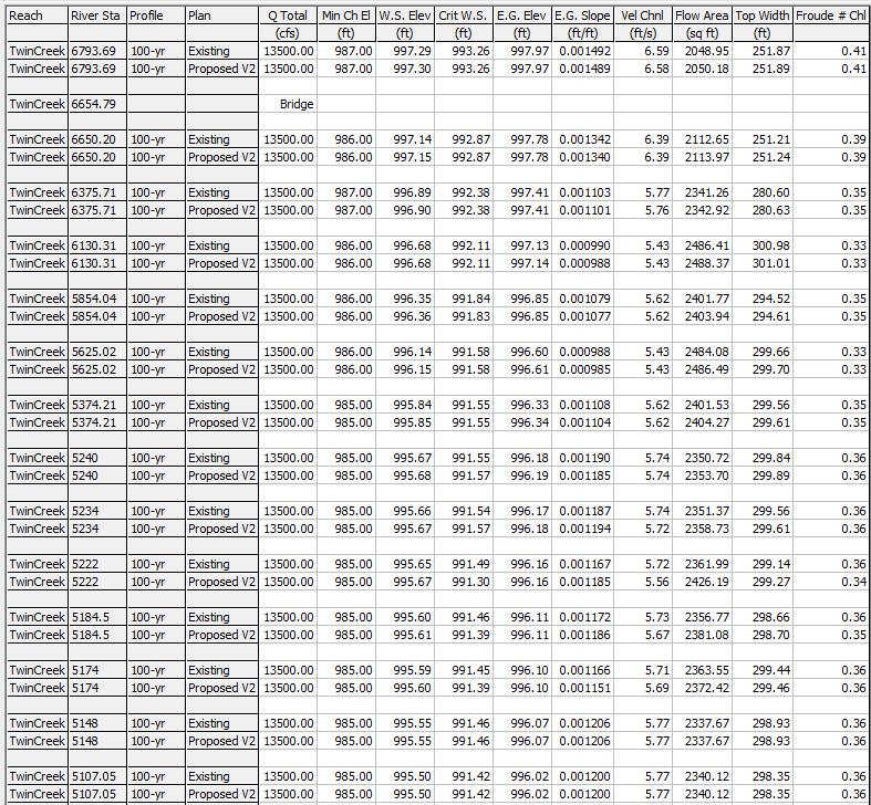
67
68 TwinCr_408_2018 Plan: 1) Existing 1/11/2019 2) Proposed V2 1/11/2019 TwinCreek TwinCreek Legend 1000 EG 100-yr - Existing EG 100-yr - Proposed V2 WS 100-yr - Proposed V2 WS 100-yr - Existing Crit 100-yr - Existing Crit 100-yr - Proposed V2 Ground 995 Left Levee Right Levee Elevation (ft) Main Channel Distance (ft)
69 TwinCr_408_2018 Plan: 1) Proposed V2 2) Existing 1000 Legend EG 100-yr - Proposed V2 998 EG 100-yr - Existing WS 100-yr - Proposed V2 WS 100-yr - Existing 996 Crit 100-yr - Proposed V2 Crit 100-yr - Existing Ground - Existing 994 Bank Sta - Existing Ground - Proposed V2 Bank Sta - Proposed V2 Elevation (ft) Station (ft)
70 TwinCr_408_2018 Plan: 1) Proposed V2 2) Existing 1000 Legend EG 100-yr - Proposed V2 998 EG 100-yr - Existing WS 100-yr - Proposed V2 WS 100-yr - Existing 996 Crit 100-yr - Proposed V2 Crit 100-yr - Existing Ground - Existing 994 Bank Sta - Existing Ground - Proposed V2 Bank Sta - Proposed V2 Elevation (ft) Station (ft)
71 TwinCr_408_2018 Plan: 1) Proposed V2 2) Existing Outfall Location 1000 Legend EG 100-yr - Proposed V2 998 EG 100-yr - Existing WS 100-yr - Proposed V2 WS 100-yr - Existing 996 Crit 100-yr - Existing Crit 100-yr - Proposed V2 Ground - Existing 994 Bank Sta - Existing Ground - Proposed V2 Bank Sta - Proposed V2 Elevation (ft) Station (ft)
72 TwinCr_408_2018 Plan: 1) Proposed V2 2) Existing End Riprap 1000 Legend EG 100-yr - Existing 998 EG 100-yr - Proposed V2 WS 100-yr - Proposed V2 WS 100-yr - Existing 996 Crit 100-yr - Existing Crit 100-yr - Proposed V2 Ground - Existing 994 Bank Sta - Existing Ground - Proposed V2 Bank Sta - Proposed V2 Elevation (ft) Station (ft)
73 TwinCr_408_2018 Plan: 1) Proposed V2 2) Existing 1000 Legend EG 100-yr - Existing 998 EG 100-yr - Proposed V2 WS 100-yr - Proposed V2 WS 100-yr - Existing 996 Crit 100-yr - Existing Crit 100-yr - Proposed V2 Ground - Existing 994 Bank Sta - Existing Ground - Proposed V2 Bank Sta - Proposed V2 Elevation (ft) Station (ft)
74 TwinCr_408_2018 Plan: 1) Proposed V2 2) Existing End of Grading 1000 Legend EG 100-yr - Existing 998 EG 100-yr - Proposed V2 WS 100-yr - Proposed V2 WS 100-yr - Existing 996 Crit 100-yr - Existing Crit 100-yr - Proposed V2 Ground - Existing 994 Bank Sta - Existing Ground - Proposed V2 Bank Sta - Proposed V2 Elevation (ft) Station (ft)
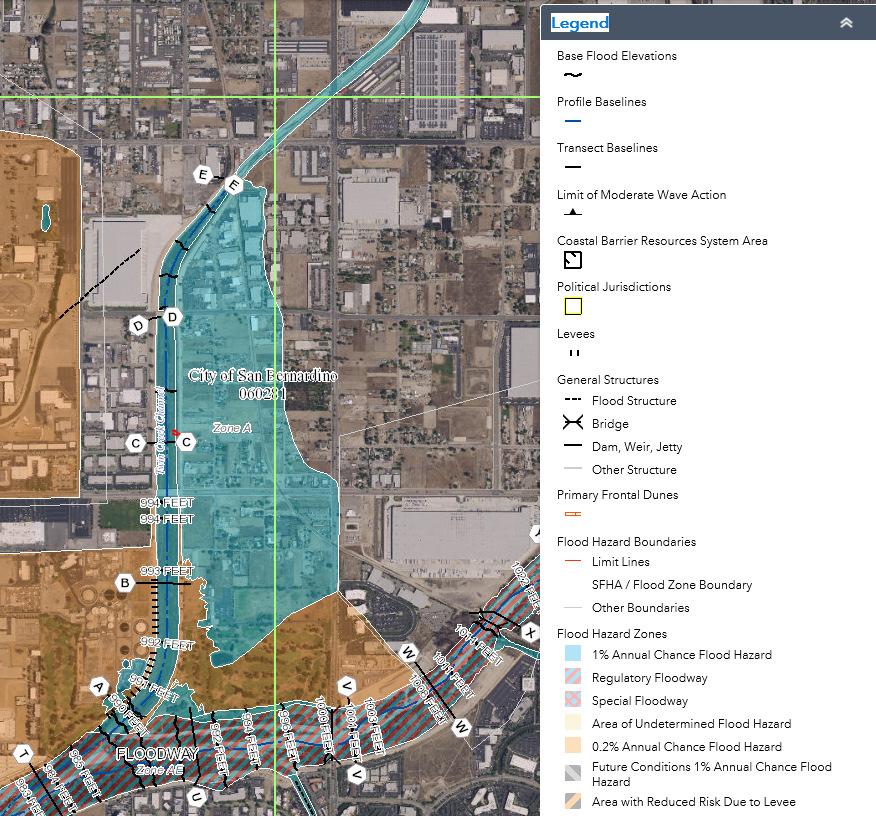
75
APPENDIX M CEQA Initial Study Checklist
 APPENDIX M CEQA Initial Study Checklist Appendix G ENVIRONMENTAL CHECKLIST FORM (To be Completed by Applicant) 1. Project title: 2. Lead agency name and address: 3. Contact person and phone number: 4.
City of Bishop. Environmental Checklist Form
 City of Bishop Environmental Checklist Form 1. Project title: Environmental Review / 2007 California Building Codes 2. Lead agency name and address: City of Bishop 377 W. Line Street Bishop, Ca 93514 3.
SECTION 9.0 Effects Found Not To Be Significant
 SECTION 9.0 Effects Found Not To Be Significant 9.0 EFFECTS FOUND NOT TO BE SIGNIFICANT The City of Santa Clarita conducted an Initial Study in April 2006 to determine significant effects of the proposed
Draft Negative Declaration of Environmental Impact. Project Title: Environmental Review / Tentative Parcel Map No.388
 Draft Negative Declaration of Environmental Date: August 7, 2008 Subject: Condominium Conversion / 287 East Line Street Project Title: Environmental Review / Tentative Parcel Map.388 Project Proponent:
Kern County Environmental Checklist Form Environmental Factors Potentially Affected
 Kern County Environmental Checklist Form Environmental Factors Affected The environmental factors checked below would be potentially affected by this project, involving at least one impact that is a potentially
CEQA Impact Key Alta East Wind Energy Project DEIR/DEIS
 CEQA Key Project NI = No ; LTS = Less than Sig; SU = Significant and Unavoidable 4.2 Air AR-1 Conflict with or obstruct implementation of the applicable air quality plan 4.3 Climate Change & Greenhouse
RESOLUTION NO. Resolution No. August 19, 2014 Page 1 of 4
 RESOLUTION NO. A RESOLUTION OF THE CITY COUNCIL OF THE CITY OF SIGNAL HILL, CALIFORNIA, APPROVING NEGATIVE DECLARATION 06/20/14(1), RELATIVE TO ZONING ORDINANCE AMENDMENT 14-02, AMENDMENTS TO TITLE 20
PROPOSED CALIFORNIA ENVIRONMENTAL QUALITY ACT (CEQA) THRESHOLDS OF SIGNIFICANCE
 THRESHOLDS OF SIGNIFICANCE") CITY OF LOS ANGELES DEPARTMENT OF CITY PLANNING PROPOSED CALIFORNIA ENVIRONMENTAL QUALITY ACT (CEQA) THRESHOLDS OF SIGNIFICANCE The City of Los Angeles Department of City Planning proposes adopting these
CITY OF LOS ANGELES DEPARTMENT OF CITY PLANNING PROPOSED CALIFORNIA ENVIRONMENTAL QUALITY ACT (CEQA) THRESHOLDS OF SIGNIFICANCE The City of Los Angeles Department of City Planning proposes adopting these
CITY OF BISHOP DRAFT 2015 ECONOMIC DEVELOPMENT ELEMENT UPDATE
 A DRAFT NEGATIVE DECLARATION CITY OF BISHOP DRAFT 2015 ECONOMIC DEVELOPMENT ELEMENT UPDATE LEAD AGENCY: City of Bishop 377 West Line Street Bishop, CA 93514 Contact: Gary Schley (760) 873-8458 In accordance
City of Eastvale Zoning Code
 INITIAL STUDY FOR A NEGATIVE DECLARATION FOR THE City of Eastvale Zoning Code Lead Agency: CITY OF EASTVALE 12363 Limonite Avenue, Suite 901 Eastvale, CA 91752 December 9, 2011 NOTICE OF PUBLIC HEARING
CITY OF SAN MATEO Initial Study
 CITY OF SAN MATEO Initial Study 1. Project Title and Number: Suhl Site Development Permit - PA10-015 2. Lead Agency Name and Address: City of San Mateo, Planning Division 330 W. 20th Avenue, San Mateo,
INSTRUCTIONS ON EVALUATION OF ENVIRONMENTAL IMPACTS
 INSTRUCTIONS ON EVALUATION OF ENVIRONMENTAL IMPACTS 1. A brief explanation is required for all answers except answers that are adequately supported by the information sources a lead agency cites in the
Draft Mitigated Negative Declaration of Environmental Impact. Subject: Proposed Draft Mitigated Negative Declaration of Environmental Impact
 Draft Mitigated Negative Declaration of Environmental Date: June 17, 2007 Subject: Proposed Draft Mitigated Negative Declaration of Environmental Project Title: Environmental Review / Vons Fuel Center
Environmental Checklist Form
 CITY OF ESCONDIDO Planning Division 201 North Broadway Escondido, CA 92025-2798 (760) 839-4671 Environmental Checklist Form 1. Project title: Downtown Marriott Hotel Project 2. Lead agency name and address:
Rocking Horse Ridge II Transfer of Territory
 ENVIRONMENTAL REVIEW FOR: Rocking Horse Ridge II Transfer of Territory Prepared by: ORANGE COUNTY COMMITTEE ON SCHOOL DISTRICT ORGANIZATION Contact: Wendy Benkert, Ed.D Secretary to the County Committee
Ruby Maldonado Project Manager, Planning, OC Development Services
 DATE: January 7, 2016 TO: FROM: Ruby Maldonado Project Manager, Planning, OC Development Services Chris Uzo-Diribe, Planning, OC Development Services SUBJECT: IP15-386 - Addendum IP 15-386 to Negative
ATTACHMENT A DISCUSSION OF ENVIRONMENTAL FACTORS ARROYO SECO BIKEWAY. a) Have a substantial adverse effect on a scenic vista?
 Have a substantial adverse effect on a scenic vista?") ATTACHMENT A DISCUSSION OF ENVIRONMENTAL FACTORS ARROYO SECO BIKEWAY I. AESTHETICS - Would the proposal: a) Have a substantial adverse effect on a scenic vista? No impact. The proposed project is not within
ATTACHMENT A DISCUSSION OF ENVIRONMENTAL FACTORS ARROYO SECO BIKEWAY I. AESTHETICS - Would the proposal: a) Have a substantial adverse effect on a scenic vista? No impact. The proposed project is not within
INITIAL STUDY & ENVIRONMENTAL CHECKLIST
 INITIAL STUDY & ENVIRONMENTAL CHECKLIST Project Title Project Location Project Description Lead Agency Contact Biological Resource Policy Update and Oak Resources Management Plan Project El Dorado County
DRAFT INITIAL STUDY/NEGATIVE DECLARATION LEAD AGENCY: CITY OF EL SEGUNDO Planning and Building Safety Department
 DRAFT INITIAL STUDY/NEGATIVE DECLARATION GENERAL PLAN AND ZONE TET AMENDMENT, USES IN THE CORPORATE OFFICE ZONE (EA 1218, GPA 18-01, AND ZTA 18-01) LEAD AGENCY: CITY OF EL SEGUNDO Planning and Building
Campus Photovoltaic Energy Project at California State University Channel Islands
 Negative Declaration and Initial Study Campus Photovoltaic Energy Project at California State University Channel Islands The Trustees of the California State University Project Proponent: California State
The following findings are hereby adopted by The Regents in conjunction with the approval of the Project which is set forth in Section III, below.
 CALIFORNIA ENVIRONMENTAL QUALITY ACT FINDINGS IN CONNECTION WITH THE APPROVAL OF THE EAST CAMPUS STUDENT HOUSING PHASE III DEVELOPMENT PROJECT UNIVERSITY OF CALIFORNIA, IRVINE I. ADOPTION OF THE MITIGATED
COUNTY OF LOS ANGELES
 COUNTY OF LOS ANGELES DEPARTMENT OF PUBLIC WORKS 900 SOUTH FREMONT AVENUE ALHAMBRA, CALIFORNIA 91803-1331 Telephone: (626) 458-5100 JAMES A. NOYES, Director www.ladpw.org ADDRESS ALL CORRESPONDENCE TO:
2018 Kings County Association of Governments RTP/SCS
 2018 Kings County Association of Governments RTP/SCS Initial Study prepared by Kings County Association of Governments 339 West D Street, Suite B Lemoore, California 93245 Contact: Terri King, Executive
ADDENDUM. to the FINAL ENVIRONMENTAL IMPACT REPORT. [State Clearinghouse No ]
![ADDENDUM. to the FINAL ENVIRONMENTAL IMPACT REPORT. [State Clearinghouse No ]](/thumbs/95/123669169.jpg "ADDENDUM. to the FINAL ENVIRONMENTAL IMPACT REPORT. [State Clearinghouse No ]") ADDENDUM to the FINAL ENVIRONMENTAL IMPACT REPORT [State Clearinghouse No. 2012061046] for the AMENDED AND RESTATED ALBERHILL VILLAGES SPECIFIC PLAN and DEVELOPMENT AGREEMENT BETWEEN THE CITY OF LAKE ELSINORE
ADDENDUM to the FINAL ENVIRONMENTAL IMPACT REPORT [State Clearinghouse No. 2012061046] for the AMENDED AND RESTATED ALBERHILL VILLAGES SPECIFIC PLAN and DEVELOPMENT AGREEMENT BETWEEN THE CITY OF LAKE ELSINORE
Proposed Initial Study/Negative Declaration
 Wireless Telecommunication Facilities Ordinance Proposed Initial Study/Negative Declaration Prepared by: City of Calabasas Planning and Community Development Department 100 Civic Center Way Calabasas,
The Village at Corte Madera Expansion Project
 The Village at Corte Madera Expansion Environmental Report Addendum State Clearinghouse Number: 2016102061 Town of Corte Madera 300 Tamalpais Drive Corte Madera, CA 94925 April 2018 The Village at Corte
Environmental Checklist Form
 Environmental Checklist Form 1. Project Title: Change of Zone No. 05-07 (Pre-Zone) and Lotus Ranch Vesting Tentative Subdivision Map 2. Lead Agency Name and Address: City of El Centro 1275 Main Street
INITIAL STUDY CHECKLIST AND PROPOSED MITIGATED NEGATIVE DECLARATION
 Attachment A INITIAL STUDY CHECKLIST AND PROPOSED MITIGATED NEGATIVE DECLARATION Downtown Riverfront Streetcar Project July 2015 Sacramento Area Council of Governments 11415 L Street, Suite 300 Sacramento,
ENVIRONMENTAL REVIEW PROCESS AND ADOPTION OF MITIGATED NEGATIVE DECLARATION
 CALIFORNIA ENVIRONMENTAL QUALITY ACT FINDINGS IN CONNECTION WITH THE APPROVAL OF LANDELS HILL-BIG CREEK NATURAL RESERVE AT THE UNIVERSITY OF CALIFORNIA, LANDELS HILL-BIG CREEK NATURAL RESERVE I. ENVIRONMENTAL
CITY OF BISHOP PROPOSED 2012 MOBILITY ELEMENT UPDATE
 DRAFT NEGATIVE DECLARATION CITY OF BISHO ROOSED 2012 MOBILITY ELEMENT UDATE LEAD AGENCY: City of Bishop 377 West Line Street Bishop, CA 93514 Contact: Gary Schley (760) 873-8458 Background, Authority and
INITIAL STUDY/NOTICE OF PREPARATION ENVIRONMENTAL IMPACT REPORT ORANGE COUNTY WATER DISTRICT PRADO BASIN SEDIMENT MANAGEMENT DEMONSTRATION PROJECT
 INITIAL STUDY/NOTICE OF PREPARATION ENVIRONMENTAL IMPACT REPORT ORANGE COUNTY WATER DISTRICT PRADO BASIN SEDIMENT MANAGEMENT DEMONSTRATION PROJECT Orange County Water District 18700 Ward Street Fountain
INITIAL STUDY AND ENVIRONMENTAL REVIEW. Daniel D. Chance, Associate Planner (707) x19
 x19") CITY OF LAKEPORT COMMUNITY DEVELOPMENT DEPARTMENT INITIAL STUDY / ENVIRONMENTAL REVIEW (GPA 16-01,ZC 16-01 and ER 16-01) INITIAL STUDY AND ENVIRONMENTAL REVIEW The application for Amendment of the City
CITY OF LAKEPORT COMMUNITY DEVELOPMENT DEPARTMENT INITIAL STUDY / ENVIRONMENTAL REVIEW (GPA 16-01,ZC 16-01 and ER 16-01) INITIAL STUDY AND ENVIRONMENTAL REVIEW The application for Amendment of the City
CITY OF LOS ANGELES OFFICE OF THE CITY CLERK ROOM 615, CITY HALL LOS ANGELES, CALIFORNIA 90012
 CITY OF LOS ANGELES OFFICE OF THE CITY CLERK ROOM 615, CITY HALL LOS ANGELES, CALIFORNIA 90012 CALIFORNIA ENVIRONMENTAL QUALITY ACT INITIAL STUDY AND CHECKLIST (Article IV B City CEQA Guidelines) LEAD
PROJECT SITE. Figure 1 Regional and Vicinity Map. Regional Location Map. Scale (Feet)
") PROJECT SITE 118 Northridge 5 210 Regional Location Map 101 North 170 Hollywood Burbank Glendale Pasadena Woodland Hills Toluca Lake PROJECT SITE 134 5 2 2 110 210 405 101 Los Angeles 10 10 60 Santa Monica
PROJECT SITE 118 Northridge 5 210 Regional Location Map 101 North 170 Hollywood Burbank Glendale Pasadena Woodland Hills Toluca Lake PROJECT SITE 134 5 2 2 110 210 405 101 Los Angeles 10 10 60 Santa Monica
5.0 LONG-TERM CEQA CONSIDERATIONS
 5.0 LONG-TERM CEQA CONSIDERATIONS Section 15126 of the CEQA Guidelines requires that all phases of a project must be considered when evaluating its impact on the environment, including planning, acquisition,
CITY OF SAN GABRIEL ENVIRONMENTAL CHECKLIST FORM
 CITY OF SAN GABRIEL ENVIRONMENTAL CHECKLIST FORM 1. Project title: Greening the Code (Planning Case. PL-13-034) 2. Lead agency name and address: City of San Gabriel, 425 S. Mission Drive, San Gabriel,
INITIAL STUDY AND PROPOSED NEGATIVE DECLARATION FOR THE INYO COUNTY 2015 ACTIVE TRANSPORTATION PLAN
 INITIAL STUDY AND PROPOSED NEGATIVE DECLARATION FOR THE INYO COUNTY 2015 ACTIVE TRANSPORTATION PLAN Prepared for Inyo County Transportation Commission 168 N. Edwards Street Independence, CA 93526 Prepared
CITY OF BANNING Initial Study/Negative Declaration
 CITY OF BANNING Initial Study/Negative Declaration General Plan Amendment and Rezoning Related to Regional Housing Needs Assessment City of Banning Community Development Department 99 E. Ramsey Street
City of Temecula Community Development
 December 15, 2011 City of Temecula Community Development Planning Division tice of Preparation And Public Scoping Meeting tice To: Subject: Agencies and Interested Parties tice of Preparation of a Draft
Prado Basin Feasibility Study Initial Study/Notice of Preparation Environmental Impact Report/Environmental Impact Statement
 Prado Basin Feasibility Study Initial Study/Notice of Preparation Environmental Impact Report/Environmental Impact Statement Orange County Water District 18700 Ward Street Fountain Valley, CA 92708 Contact:
TABLE OF CONTENTS. Mitigated Negative Declaration Form/CEQA Initial Study Checklist (front insert) I. INTRODUCTION... I-1 PROJECT DESCRIPTION...
 I. INTRODUCTION... I-1 PROJECT DESCRIPTION...") TABLE OF CONTENTS Mitigated Negative Declaration Form/CEQA Initial Study Checklist (front insert) I. INTRODUCTION... I-1 II. PROJECT DESCRIPTION... II-1 A. PROJECT LOCATION... II-1 B. PROJECT CHARACTERISTICS...
TABLE OF CONTENTS Mitigated Negative Declaration Form/CEQA Initial Study Checklist (front insert) I. INTRODUCTION... I-1 II. PROJECT DESCRIPTION... II-1 A. PROJECT LOCATION... II-1 B. PROJECT CHARACTERISTICS...
APPENDIX A NOP AND COMMENT LETTERS
 APPENDIX A NOP AND COMMENT LETTERS N O T I C E O F P R E P A R A T I O N DATE: December 19, 2005 TO: LEAD AGENCY: SUBJECT: State Clearinghouse, Responsible Agencies, Trustee Agencies, Organizations and
WHITTIER NARROWS WATER RECLAMATION PLANT DIVERSION
 Draft WHITTIER NARROWS WATER RECLAMATION PLANT DIVERSION Initial Study Prepared for July 2018 Sanitation Districts of Los Angeles County Draft WHITTIER NARROWS WATER RECLAMATION PLANT DIVERSION Initial
INITIAL STUDY/ NEGATIVE DECLARATION
 INITIAL STUDY/ NEGATIVE DECLARATION INITIAL STUDY/ NEGATIVE DECLARATION Project Title: Lead Agency Name and Address: Project Location: Project Sponsor s Name and Address: General Plan Designation(s): Zoning:
CITY OF LOS ANGELES OFFICE OF THE CITY CLERK ROOM 395, CITY HALL LOS ANGELES, CALIFORNIA 90012
 LEAD CITY AGENCY Department of City Planning RESPONSIBLE AGENCIES CITY OF LOS ANGELES OFFICE OF THE CITY CLERK ROOM 395, CITY HALL LOS ANGELES, CALIFORNIA 90012 CALIFORNIA ENVIRONMENTAL QUALITY ACT INITIAL
Proposed Mitigated Negative Declaration. Yorba Linda Pump Station Abandonment Project. Fullerton, California. Orange County Sanitation District
 Proposed Mitigated Negative Declaration Yorba Linda Pump Station Abandonment Project Fullerton, California Prepared for Orange County Sanitation District Prepared by December 2014 Initial Study Yorba
EL DORADO COUNTY PLANNING SERVICES 2850 FAIRLANE COURT PLACERVILLE, CA ENVIRONMENTAL CHECKLIST FORM AND DISCUSSION OF IMPACTS
 Project Title: COC05-0164 EL DORADO COUNTY PLANNING SERVICES 2850 FAIRLANE COURT PLACERVILLE, CA 95667 ENVIRONMENTAL CHECKLIST FORM AND DISCUSSION OF IMPACTS Lead Agency Name and Address: El Dorado County,
Carpinteria Valley Water District Carpinteria Advanced Purification Project
 NOTICE OF PREPARATION AND SCOPING MEETING Carpinteria Valley Water District Carpinteria Advanced Purification Project TO: Agencies, Organizations, and Interested Parties DATE: January 7, 2019 SUBJECT:
APPENDIX A INITIAL STUDY
 City of Los Angeles May 2009 APPENDIX A INITIAL STUDY Draft Environmental Impact Report Technical Appendices Environmental Review Section City Hall 200 N. Spring Street, Room 750 Los Angeles, CA 90012
NEGATIVE DECLARATION. Document Released
 NEGATIVE DECLARATION Pursuant to Division 6, Title 14, Chapter 3, Article 6, Sections 15070 and 15071 of the California Administrative Code and pursuant to the Procedures for Preparation and Processing
Environmental Initial Study Parks Master Plan City of La Mesa, County of San Diego, CA
 Environmental Initial Study Parks Master Plan City of La Mesa, County of San Diego, CA Lead Agency: City of La Mesa 4975 Memorial Drive La Mesa, CA 91942 619-667-1308 Contact: Mike Pacheco, Project Manager
CITY OF EL CENTRO PUBLIC REVIEW NOTICE OF INTENT TO ADOPT NEGATIVE DECLARATION NO
 CITY OF EL CENTRO PUBLIC REVIEW NOTICE OF INTENT TO ADOPT NEGATIVE DECLARATION NO. 14-01 tice is hereby given that a Negative Declaration has been prepared for Change of Zone 14-01 & General Plan Amendment
BRISTOL STREET CORRIDOR SPECIFIC PLAN & GENERAL PLAN AMENDMENT
 BRISTOL STREET CORRIDOR SPECIFIC PLAN & GENERAL PLAN AMENDMENT ADDENDUM TO THE FINAL BRISTOL STREET CORRIDOR SPECIFIC PLAN EIR State Clearinghouse No. 87101404 Prepared for: City of Santa Ana 20 Civic
INITIAL STUDY ENVIRONMENTAL CHECKLIST FORM
 DEPARTMENT OF PUBLIC WORKS AND PLANNING STEVEN E. WHITE, DIRECTOR INITIAL STUDY ENVIRONMENTAL CHECKLIST FORM 1. Project title: Initial Study No. 7420 and Unclassified Conditional Use Permit No. 3599 2.
Mitigated Negative Declaration. MacArthur Pump Station Rehabilitation Project. Newport Beach, California. Orange County Sanitation District
 Mitigated Negative Declaration MacArthur Pump Station Rehabilitation Project Newport Beach, California Prepared for Orange County Sanitation District Prepared by January 2015 Initial Study MacArthur
MARCH 29, 2016 GGRO007
 INITIAL STUDY AND MITIGATED NEGATIVE DECLARATION CONDITIONAL USE PERMIT (CUP) NO. 073-2016 HEAVEN S GATE FUNERAL HOME 13272 GARDEN GROVE BOULEVARD GARDEN GROVE, CALIFORNIA LEAD AGENCY: CITY OF GARDEN GROVE
As noted, the Marblehead EIR included an environmental analysis of a fully operational, approximately 750,000-square-foot regional commercial center,
 Initial Study 1. Project Title: Freeway-Oriented Signage for The Outlets at San Clemente 2. Lead Agency Name and Address: City of San Clemente 100 Avenida Presidio San Clemente, CA 92673 3. Contact Person
MAMMOTH COMMUNITY WATER DISTRICT Initial Study/Mitigated Negative Declaration
 MAMMOTH COMMUNITY WATER DISTRICT Initial Study/Mitigated Negative Declaration Pursuant to the California Environmental Quality Act and CEQA Guidelines, the Mammoth Community Water District proposes to
5. OTHER CEQA CONSIDERATIONS
 5. OTHER CEQA CONSIDERATIONS Cumulative Impacts CEQA requires the analysis of impacts due to cumulative development that would occur independent of, but during the same timeframe as, the project under
INITIAL STUDY Environmental Checklist and Evaluation for Santa Clara County
 INITIAL STUDY Environmental Checklist and Evaluation for Santa Clara County File Number: 10061-00-00-09Z Date: September 10, 2010 Project Type: Zoning Ordinance Update APN(s): Multiple Project Location
ADOPTION OF THE MITIGATED NEGATIVE DECLARATION
 CALIFORNIA ENVIRONMENTAL QUALITY ACT IN CONNECTION WITH THE APPROVAL OF THE TELECOMMUNICATIONS INFRASTRUCTURE IMPROVEMENTS PHASE A PROJECT UNIVERSITY OF CALIFORNIA, SANTA CRUZ CAMPUS I. ADOPTION OF THE
YOLO COUNTY COMMUNITY SERVICES DEPARTMENT INITIAL STUDY/NEGATIVE DECLARATION
 YOLO COUNTY COMMUNITY SERVICES DEPARTMENT INITIAL STUDY/NEGATIVE DECLARATION RAVINE SPORTS BAR & GRILL USE PERMIT ZONE FILE # 2017-0074 vember 2017 Initial Environmental Study 1. Project Title: Zone File
County o Fresno is Times New DRADRAFT NOTICE OF DETERMINATION
 County o Fresno is Times New DRADRAFT NOTICE OF DETERMINATION DEPARTMENT OF PUBLIC WORKS AND PLANNING STEVEN E. WHITE, DIRECTOR To: Office of Planning and Research County Clerk, County of Fresno 1400 Tenth
Kress Project Environmental Initial Study and Mitigated Negative Declaration. For: Design Review, Conditional Use Permit, and Lot Line Adjustment
 Kress Project Environmental Initial Study and Mitigated Negative Declaration For: Design Review, Conditional Use Permit, and Lot Line Adjustment Owner: David and Collette Kress Saratoga, CA 95070 Public
INITIAL STUDY ANDADDENDUM TO THE 2006 TRANSBAY CABLE PROJECT EIR
 INITIAL STUDY ANDADDENDUM TO THE 2006 TRANSBAY CABLE PROJECT EIR MAY 2013 PREPARED FOR: CITY OF PITTSBURG 65 CIVIC AVENUE PITTSBURG, CA 94565 PREPARED BY: JOAN LAMPHIER CONSULTING PLANNER JML PLANNING
RELATED CASES: VTT-63479
 LEAD CITY AGENCY: LOS ANGELES DEPARTMENT OF CITY PLANNING RESPONSIBLE AGENCIES: ENVIRONMENTAL CASE: ENV-2005-7196-MND(REC2) PREVIOUS ACTIONS CASE NO.: PROJECT DESCRIPTION: 81-UNIT RESIDENTIAL CONDOMINIUM
INITIAL STUDY AND PROPOSED NEGATIVE DECLARATION
 Final INITIAL STUDY AND PROPOSED NEGATIVE DECLARATION FOR THE EWD Diffused Surface Water Program Sand Creek Managed Aquifer Recharge (MAR) Project Prepared by: Eastside Water District P.O. Box 280 Denair,
INITIAL STUDY City of Oceanside California
 INITIAL STUDY City of Oceanside California 1. PROJECT: 2. LEAD AGENCY: City of Oceanside 3. CONTACT PERSON & PHONE: 4. PROJECT LOCATION: 5. APPLICANT: 6. GENERAL PLAN DESIGNATION: 7. ZONING: 8. PROJECT
NOTICE OF PREPARATION DUBLIN HIGH SCHOOL ENGINEERING & SCIENCE BUILDING AND INTERIM HOUSING PHASE 1B ENVIRONMENTAL IMPACT REPORT
 NOTICE OF PREPARATION DUBLIN HIGH SCHOOL ENGINEERING & SCIENCE BUILDING AND INTERIM HOUSING PHASE 1B ENVIRONMENTAL IMPACT REPORT To: State Clearinghouse Governor s Office of Planning & Research Responsible
DRAFT NEGATIVE DECLARATION OF ENVIRONMENTAL IMPACT AND INITIAL STUDY
 Planning Department 168 North Edwards Street Post Office Drawer L Independence, California 93526 Phone: (760) 878-0263 FAX: (760) 878-0382 E-Mail: inyoplanning@ Inyocounty.us DRAFT NEGATIVE DECLARATION
City of Santa Monica Santa Monica Single-use Carryout Bag Ordinance. Initial Study
 Santa Monica Single-use Carryout Bag Ordinance March 2010 Santa Monica Single-use Carryout Bag Ordinance Prepared by: Office of Sustainability and the Environment 200 Santa Monica Pier, Suite D Santa Monica,
Mitigated Negative Declaration and Initial Study Student Residence Hall
 Mitigated Negative Declaration and Initial Study Student Residence Hall California State University, Sacramento July 2014 Mitigated Negative Declaration Student Residence Hall California State University,
CITY OF LOMPOC ENVIRONMENTAL CHECKLIST FORM
 CITY OF LOMPOC ENVIRONMENTAL CHECKLIST FORM A. PROJECT INFORMATION: Project Title: Housing Authority of the County of Santa Barbara Lead Agency Name and Address: City of Lompoc 100 Civic Center Plaza,
Addendum No. 1 to the Duke Warehouse at Perris Boulevard and Markham Street Environmental Impact Report
 Addendum No. 1 to the Duke Warehouse at Perris Boulevard and Markham Street Environmental Impact Report Perris, California SCH No. 2017081059 Project Applicants: Duke Realty Limited Partnership 300 Spectrum
INITIAL STUDY/MITIGATED NEGATIVE DECLARATION
 INITIAL STUDY/MITIGATED NEGATIVE DECLARATION BOULDER AVENUE BRIDGE REPLACEMENT PROJECT CITY OF HIGHLAND SAN BERNARDINO COUNTY, CALIFORNIA December 11, 2008 INITIAL STUDY/MITIGATED NEGATIVE DECLARATION
1. Executive Summary EXECUTIVE SUMMARY. County of Imperial August 2012 Hudson Ranch Power II and Simbol Calipatria II
 1 EXECUTIVE SUMMARY Hudson Ranch Power II and Simbol Calipatria II Final EIR This page intentionally left blank. Hudson Ranch Power II and Simbol Calipatria II Final EIR 1 EXECUTIVE SUMMARY This section
INITIAL STUDY/MITIGATED NEGATIVE DECLARATION FOR LA SIERRA METROLINK PARKING LOT EXPANSION PROJECT
 INITIAL STUDY/MITIGATED NEGATIVE DECLARATION FOR LA SIERRA METROLINK PARKING LOT EPANSION PROJECT Prepared By: Riverside County Transportation Commission 4080 Lemon Street Riverside, California 92501 March
Initial Study and Proposed Negative Declaration for the Alpine County 2010 Regional Transportation Plan
 Initial Study and Proposed Negative Declaration for the Alpine County 2010 Regional Transportation Plan Prepared for the Alpine County Local Transportation Commission Prepared by TRANSPORTATION CONSULTANTS,
AGENDA REPORT. LED Streetlight Upgrade Program Initial Study/ Mitigated Negative Declaration
 CITY OF PACIFIC GROVE 300 Forest Avenue, Pacific Grove, California 93950 AGENDA REPORT Agenda. 12A Page 1 of 3 TO: FROM: MEETING DATE: April 18, 2018 SUBJECT: CEQA: Honorable Mayor and Members of City
OTHER CEQA CONSIDERATIONS
 Chapter 5 OTHER CEQA CONSIDERATIONS CEQA Guidelines Section 15128 requires that an EIR disclose the reasons why various possible environmental effects of a proposed project are found not to be significant
CEQA Environmental Checklist
 CEQA Environmental Checklist PROJECT DESCRIPTION AND BACKGROUND Project Title: January 2017 Service Changes Lead agency name and address: Sacramento Regional Transit District, P.O. Box 2110, 1400 29 th
Proposed Mitigated Negative Declaration of Environmental Impact. Project Title: South Second Street Improvements Project
 CITY OF BISHOP 377 West Line Street - Bishop, California 93514 Post Office Box 1236 - Bishop, California 93515 760-873-8458 publicworks@ca-bishop.us www.ca-bishop.us/cityofbishoppublicworks.htm Proposed
2. Surrounding Uses F I G U R E 3: SECTION II. PROJECT DESCRIPTION PAGE II-3
 SECTION II. PROJECT DESCRIPTION PAGE II-3 2. Surrounding Uses An aerial photograph from Google Earth (2016) shows adjacent agricultural industrial uses south and east of the project. Agricultural uses
CEDARS-SINAI MEDICAL CENTER WEST TOWER PROJECT ENV EIR APPENDIX A NOTICE OF PREPARATION INITIAL STUDY PUBLIC SCOPING COMMENTS
 CEDARS-SINAI MEDICAL CENTER WEST TOWER PROJECT ENV 2008-0620-EIR APPENDIX A NOTICE OF PREPARATION INITIAL STUDY PUBLIC SCOPING COMMENTS CEDARS-SINAI MEDICAL CENTER WEST TOWER PROJECT ENV 2008-0620-EIR
CITY OF MERCED WASTEWATER TREATMENT PLANT EXPANSION PROJECT
 Volume II Appendices CITY OF MERCED WASTEWATER TREATMENT PLANT EXPANSION PROJECT Draft Environmental Report SCH No. 2005101135 Prepared by: City of Merced August 2006 Volume II Appendices CITY OF MERCED
ENV MND Page 1 of 22
 LEAD CITY AGENCY City of Los Angeles PROJECT TITLE ENV-2012-1361-MND PROJECT LOCATION 20600 W ROSCOE BLVD CITY OF LOS ANGELES OFFICE OF THE CITY CLERK ROOM 395, CITY HALL LOS ANGELES, CALIFORNIA 90012
General Plan Housing Element 5 th Cycle Update
 General Plan Housing Element 5 th Cycle Update Initial Study Negative Declaration December 2014 INITIAL STUDY GENERAL PLAN HOUSING ELEMENT 5 TH CYCLE UPDATE Prepared for 100 Civic Center Plaza Lompoc,
PROTECT OAKLAND: UPDATE OF THE SAFETY ELEMENT OF THE OAKLAND GENERAL PLAN
 PROTECT OAKLAND: UPDATE OF THE SAFETY ELEMENT OF THE OAKLAND GENERAL PLAN Initial Study / Negative Declaration Document submitted for public review on: September 15, 2004 Comments may be submitted to:
APPENDIX A. Notice of Preparation (NOP) and Initial Study
 and Initial Study") APPENDIX A Notice of Preparation (NOP) and Initial Study SANTA MONICA COLLEGE CALIFORNIA ENVIRONMENTAL QUALITY ACT (CEQA) INITIAL STUDY CHECKLIST PROJECT TITLE DATE: September 22, 2009 LEAD AGENCY:
APPENDIX A Notice of Preparation (NOP) and Initial Study SANTA MONICA COLLEGE CALIFORNIA ENVIRONMENTAL QUALITY ACT (CEQA) INITIAL STUDY CHECKLIST PROJECT TITLE DATE: September 22, 2009 LEAD AGENCY:
Incremental Recycled Water Program 2007 ADDENDUM TO PROGRAM ENVIRONMENTAL IMPACT REPORT
 SANTA ROSA SUBREGIONAL WATER REUSE SYSTEM Incremental Recycled Water Program 2007 ADDENDUM TO PROGRAM ENVIRONMENTAL IMPACT REPORT SCH #2002072046 March 2007 SANTA ROSA SUBREGIONAL WATER REUSE SYSTEM 2007
INITIAL STUDY AND ENVIRONMENTAL REVIEW CHECKLIST California Environmental Quality Act (CEQA)
") INITIAL STUDY AND ENVIRONMENTAL REVIEW CHECKLIST California Environmental Quality Act (CEQA) 1. Project Title: Pedestrian Master Plan for Unincorporated Areas 2. Lead Agency Name and Address: County of
INITIAL STUDY AND ENVIRONMENTAL REVIEW CHECKLIST California Environmental Quality Act (CEQA) 1. Project Title: Pedestrian Master Plan for Unincorporated Areas 2. Lead Agency Name and Address: County of
ADDENDUM TO THE CITY OF LAKEPORT GENERAL PLAN EIR
 ADDENDUM TO THE CITY OF LAKEPORT GENERAL PLAN EIR OCTOBER 24, 2014 Prepared for: City of Lakeport Community Development Department 225 Park Street Lakeport, CA 95453 Prepared by: De Novo Planning Group
225 Bush Street Suite 1700 San Francisco, CA phone fax
 225 Bush Street Suite 1700 San Francisco, CA 94104 415.896.5000 phone 415.896.0332 fax www.esassoc.com memorandum date October 10, 2011 to from subject Lori Alvarez Project Manager, Palo Alto School District
Initial Study Gold s Gym Building !! " % & City of Commerce COMM 056 July Page 1
 !! " #$ % & COMM 056 July 2006 Page 1 Section '()*+*,'),' Page,...3 -....13 1.1 Purpose of...14 1.2 Format of...14. /0!...15 2.1 Project Location...16 2.2 Environmental Setting...16 2.3 Physical and Operational
CITY OF LOS ANGELES CALIFORNIA ENVIRONMENTAL QUALITY ACT INITIAL STUDY (Article I - City CEQA Guidelines)
") CITY OF LOS ANGELES CALIFORNIA ENVIRONMENTAL QUALITY ACT INITIAL STUDY (Article I - City CEQA Guidelines) Council District: 1,2,3,4,5,6,9,12,13,14 Date: 3/27/2008 Lead City Agency: Project Title: Department
CITY OF LOS ANGELES CALIFORNIA ENVIRONMENTAL QUALITY ACT INITIAL STUDY (Article I - City CEQA Guidelines) Council District: 1,2,3,4,5,6,9,12,13,14 Date: 3/27/2008 Lead City Agency: Project Title: Department
ENVIRONMENTAL CHECKLIST FORM
 ENVIRONMENTAL CHECKLIST FORM 1. Project Title: Conditional Use Permit. 1018 2. Lead Agency Name and Address: City of Redlands Community Development Department 210 E. Citrus Avenue Redlands, CA 92373 3.
Draft Initial Study and Proposed Negative Declaration. Redirected Contract PG&E Water from the Miocene Canal to the Thermalito Power Canal
 Draft Initial Study and Proposed Negative Declaration for the Redirected Contract PG&E Water from the Miocene Canal to the Thermalito Power Canal Lead Agency: Butte County Department of Water & Resource
ORDINANCE NO
 ORDINANCE NO. 15-937 AN ORDINANCE OF THE CITY COUNCIL OF THE CITY OF LA PUENTE AMENDING TABLE 2-5 (CM ZONE-ALLOWED USES AND PERMIT REQUIREMENTS) OF SECTION 10.14.020 (LAND USE REGULATIONS) OF CHAPTER 10.14
November 2006 NOP and IS
 November 2006 NOP and IS NOTICE OF PREPARATION TO: Distribution List (Attached) Lead Agency: Consulting Firm: Agency Name: City of Santa Clarita Name: Sciences Street 23920 Valencia Boulevard, Street Address:
City of Baldwin Park Health and Sustainability Element. Initial Study Negative Declaration
 City of Baldwin Park Health and Sustainability Element Initial Study Negative Declaration Lead Agency: City of Baldwin Park Planning Division 14403 East Pacific Avenue Baldwin Park, California 91706 Consultant