Improving the condition of Solway Tweed s water environment Tweed area management plan
|
|
|
- Samantha Gordon
- 6 years ago
- Views:
Transcription
1 Improving the condition of Solway Tweed s water environment Tweed area management plan Supplementary to the river basin management plan for the Solway Tweed river basin district Page 1 of 20
2 Contents Introduction to the Tweed area management plan Aims of this area management plan Area covered in this plan Condition of the water environment in the Tweed area Condition of the surface water and groundwater Condition of protected areas Reasons why some water bodies are not in good condition Targets for the water environment in the Tweed area Delivering these targets Actions to meet our targets Ensuring integration for effective and efficient delivery Working together in the future Appendix 1: Relevant actions abridged from the Tweed catchment management plan Page 2 of 20
3 Introduction The water environment of the Tweed forms a vital part of the area s economy, community, wildlife and landscape. It contributes to the economy by supporting key industries such as farming, tourism and fishing. It also provides our drinking and bathing waters while supporting internationally important habitats and their species. It is therefore in everyone s interest to ensure that it is maintained and improved wherever possible. Aims of this area management plan This area management plan has been produced to focus our attention of the condition of the water environment in the Tweed area and what actions are necessary to maintain and improve it. This plan presents the current condition of the water environment in the Tweed area and goes on to outline the actions required to maintain and/or improve this environment over the next six years and beyond. These targets have been developed as part of the Solway Tweed river basin management plan published in December 2009 as a requirement of the Water Framework Directive (see for more information). As the waters in the Tweed straddle the English and Scottish Border, this plan has been developed jointly by SEPA and the Environment Agency, incorporating the experience and skills of the long established Tweed Forum, which has been delivering catchment scale improvements since 1991 through internationally acclaimed partnership working and delivery of the Tweed catchment management plan. The members of the Tweed Forum Executive Committee, supplemented by several key stakeholders, meet as the Tweed Area Advisory Group and have helped to inform and shape this plan. Membership of the Tweed Area Advisory Group is made up of representatives from the following organisations. Ahlstrom Chirnside Berwickshire and North Northumberland Coast European Marine Site Consumer Council for Water Country Land and Business Association Environment Agency Forestry Commission Scotland National Farmers Union Scotland Natural England Northumberland County Council Northumberland National Park Authority Northumberland Wildlife Trust Northumbrian Water Limited The River Tweed Commission Royal Society for the Protection of Birds Scottish Borders Council Scottish Environment Protection Agency Scottish Government Rural Payments and Inspectorate Division Scottish Rural Property and Business Association Scottish Natural Heritage Scottish Water Tweed Forum Staff Tweed Foundation This document has been designed to supplement the Solway Tweed river basin management plan and dovetail with the Tweed catchment management plan ( Area covered in this plan This plan includes information on the Tweed water environment, defined as surface waters (eg rivers, lochs, estuaries and coastal water bodies) and those beneath the ground (groundwaters). It considers rivers with a catchment area of more than 10 km 2 and lochs with a surface area greater than 0.5 km 2. Using these criteria this plan covers 166 river water bodies along the River Tweed and its tributaries (Gala, Ettrick, Teviot, and the Till to the south and the River Whiteadder in the north), 6 Page 3 of 20
4 lochs, the estuary at the mouth of the Tweed at Berwick upon Tweed and 33 groundwater bodies (see Map 1). The Water Framework Directive requires targets to be set for wetland areas that depend either on groundwater or surface water. The current groundwater body classification includes an assessment of the impact from groundwater quantity pressures on wetlands, and in the English water bodies the impact from groundwater quality pressures is also assessed. Both the Environment Agency and SEPA aim to classify and set targets for all types of wetland for future river basin cycles. To enable this process, work has begun on the assessment of wetland types and to improve our understanding of the influences and interactions between wetlands, groundwater and surface waters. This includes establishing a Scotland wetland inventory which will incorporate data and research from initiatives such as the recently produced Tweed wetland strategy 2010 and the Cairngorms wetland vision 2010, along with additional research and monitoring and ongoing UK and European Union co-operation. To the north of the Tweed catchment lies the Eye catchment, which falls within the Scottish Forth advisory group area and is led by SEPA. To the south lies the Northumbrian river basin district, which is led by the Environment Agency. Map 1: Area covered in this plan the Tweed advisory group area Page 4 of 20
5 Condition of the water environment in the Tweed area The condition of the water environment is monitored and assessed as one of five classes: high, good, moderate, poor or bad. A water body at high status is considered to be in an almost natural condition. Groundwaters are classified as either good or poor for both water quality and water quantity. These classes, and the standards they represent, apply across the UK and have been agreed across Europe. The focus of the Water Framework Directive is to ensure that all water bodies reach good status and do not deteriorate to less than good status. Some surface waters in the Tweed are have been designated as heavily modified water bodies (HMWB), which means they have been physically modified for a specific use such as drinking water reservoirs or flood embankments. These water bodies are classified according to five classes by ecological potential instead of status, which is a measure of the extent to which each water body s ecological quality has been maximised within the limits imposed by the physical modifications necessary for its use. No water bodies have been designated as artificial in the Tweed area, using the criteria used under the Water Framework Directive, although man has influenced the environment over many generations. The classification scheme contains many elements and uses datasets collected over many years in combination with data on newly monitored aspects of the natural environment. Thus, some of the classification results presented in this plan are based on long term datasets, which allow us to make assessments with high confidence levels, while others are based on data collected over only one or two years or are calculated using a modelled approach and so our confidence in these assessments are lower. Nevertheless, the data presented here gives a complete picture of water ecosystem health for the whole Tweed catchment for the first time. The classification scheme will continue to be developed and new data added as river basin planning progresses, thus there is the provision to fine tune the classification assessments over subsequent years. Condition of surface waters and groundwater Table 1 presents the current overall classification of water bodies in the Tweed area, and Map 2 shows their geographical distribution. Just over half (52%) of the natural surface waters in the Tweed area are in good or better condition. The remainder of natural surface waters are mostly in moderate condition (38%) or poor (10%). Around two thirds (66%) of heavily modified water bodies are at less than good ecological potential. The majority of groundwaters (88%) are currently in good condition, with those in the east assessed as poor for water chemistry, water quantity or both (Map 3). As more data is collected, and the newly introduced classification tools improve, our understanding in some aspects of the classification scheme will increase. The pressures and risks affecting the Tweed water environment are discussed in the Reasons why some water bodies are not in good condition chapter of this document. Table 1: Condition of surface waters and groundwater in the Tweed area in 2008 Number of water bodies 2008 condition All water Surface waters (status/potential) Groundwater* bodies Natural Heavily modified High/Maximum Page 5 of 20

6 Good Moderate Poor Bad Totals Proportion good or better (%) * Bodies of groundwater are classed as either of good status or poor status. Map 2: Condition of surface waters in the Tweed catchment using 2008 information, as presented in the Solway Tweed river basin plan Page 6 of 20

7 Map 3: Condition of groundwater across the Solway Tweed river basin district using 2008 information, as presented in the Solway Tweed river basin plan Condition of protected areas A large proportion of the water environment in the Tweed area has been identified as requiring special protection because of its particular economic, social or environmental importance or sensitivity to pollution. These areas are water bodies or parts of water bodies that: are used for drinking water supply; support economically significant shellfish or freshwater fish stocks; are designated bathing waters; support habitats or species of international biodiversity conservation importance; are sensitive to nutrient enrichment. Page 7 of 20
8 These areas represent some of the area s most valued natural assets. By protecting them we will help safeguard biodiversity, sustain employment in our rural communities and protect our drinking water sources from pollution. The classifications of the protected areas in the Tweed catchment are described in the Solway Tweed river basin plan ( and can be summarised as: five Special Area of Conservation sites, all achieving favourable status with the exception of the River Tweed Special Area of Conservation (see the Targets for the water environment in the Tweed area chapter of this document); seven Special Protection Area sites, all at favourable status; salmon fisheries across the Tweed catchment are in good condition; bathing waters at Spittal Beach are currently in poor condition; Nitrate Vulnerable Zones in the Lothian/Borders and Cornhill on Tweed; Drinking Water Protection Zones, none of which have been identified as at risk of deterioration. The majority of these sites are currently meeting the standards set for them; the exceptions and their targets for improvement are discussed in the Targets for the water environment in the Tweed area chapter of this document. Page 8 of 20
9 Reasons why water bodies are not in good condition The key pressures and risks causing Tweed water bodies and protected areas to be at less than good ecological status are: nutrient enrichment from diffuse pollution (pollution coming from several dispersed sources) from rural land management; alterations to beds, banks and shores through rural land use activities, for example channel straightening for drainage on land used for livestock, forestry and mixed farming activities and barriers to fish migration; abstraction of water from rivers and lochs for public water supply and farming; the presence or risk posed by introduction of invasive non-native species such as the American Signal Crayfish; This list of key issues does not cover all the pressures found in the Tweed area; detailed information on the individual classifications, pressures and actions for each water body is available from the interactive maps and water body information sheets at: Page 9 of 20
10 Targets for the water environment in the Tweed area The Solway Tweed river basin management plan has two broad aims: to prevent deterioration in the water bodies currently in good or better condition; to improve and restore those currently in moderate, poor or bad condition. Almost 56% of water bodies in the Tweed area are currently at good or better status, so the target for these water bodies is to maintain this status over the coming years. Action is required to improve the remaining surface and groundwaters to good or better condition by 2027 (Table 2). The long-term view (through to 2027) of phased improvement allows us to take the potential cost and feasibility of the work that needs to happen into account, whilst managing uncertainties such as confidence in the monitoring results or the impact of climate change. Table 2: Number and proportion of water bodies at good or high ecological status (%) Total no. of water No. of water bodies with percentage (%) at good or better Number and proportion (%) bodies of water bodies remaining less than good by 2027 All surface water bodies % % % % 3 2% Rivers - natural % 58% 78% 98% 2% Rivers - HMWB % 39% 46% 100% 0% Lochs - HMWB % 83% 83% 100% 0% Estuaries natural 100% 100% 100% 100% 0% Groundwater quality % 30 91% 30 91% 31 94% 2 6% Groundwater quantity % 30 91% 30 91% % 0 0% The bathing water at Spittal beach is predicted to achieve the sufficient standard by 2015 as defined by the Bathing Water Directive, while the River Tweed Special Area of Conservation is assessed by Scottish Natural Heritage as having unfavourable status due to alien species and diffuse pollution from agricultural sources (as defined by the Habitat Directive), and should be favourable or at least show signs of recovery by There are circumstances under which deterioration in status may be considered acceptable. Such exemptions occur when it is judged that the benefits would improve human health, maintain human safety, allow sustainable development or be in the overriding public interest. To date there are no water bodies in Solway or Tweed area where exemptions have been allowed. For five water bodies, it is judged that good status cannot be achieved even by For the most part this is because there is currently no feasible and effective way to make the necessary improvements. For these water bodies, we have set a lower, or less stringent, objective than good status. Two water bodies are affected by the presence of North American Signal Crayfish, an invasive non-native species. It is currently judged to be technically infeasible to remove Page 10 of 20
11 established populations of North American signal crayfish, or sufficiently mitigate their impact, in order to achieve good ecological status by Winterhope Burn is currently impassable to fish and its target for 2027 will be to remain at poor status. Two groundwater bodies, around Coldstream and Duns, will remain poor for groundwater quantity beyond Page 11 of 20
12 Delivering these targets Meeting these targets will be a big challenge because maintaining or improving the current condition will be a challenge in the face of many factors such as development pressures, changes in agricultural production and climate change. Phasing the improvements over three six-year cycles will allow time to monitor and improve our confidence in our classifications, secure funding and implement measures, track progress and, where appropriate and necessary, adapt the plan. This also means that we can respond to uncertainties, for example around how to tackle particular pressures or the impacts of climate change. Comprehensive reviews of progress will be undertaken during each river planning period and will be reported in updates of this plan. Actions to meet our targets There are many actions currently underway or about to begin in the Tweed area which will deliver on our targets. A summary of local actions in place to mitigate the main pressures to 2015, and beyond, is presented in Table 3. The actions required to deliver the targets consist of a combination of monitoring, data collation, regulation, investment, awareness raising and guidance work led by agencies, stakeholders or partnerships. The work varies considerably in scale, from small projects on a river bank to catchment-wide initiatives examining mitigation of alterations to beds and banks or invasive nonnative species. As river basin planning is new, many of the actions to be implemented in the first cycle involve the collection or collation of data, increasing our confidence around the environmental pressures, the development of working groups to discuss implementation methods and the development of options for implementation (or scoping studies). These actions should evolve into active projects resulting in improvements to classification status as time progresses. Page 12 of 20
13 Invasive non-native species Alterations to beds, banks and shores Abstraction of water Diffuse pollution from rural land management Table 3: Summary of local actions needs to meet the targets set for Tweed Timeframe Action SEPA and Environment Agency actions (regulatory and non regulatory) Tweed wetland strategy and collation of data Tweed catchment management plan strategic aim 1 Revise Scottish Borders rivers and burns habitat action plan Collaborative Action Project Officer Scotland Rural Development Programme Catchment sensitive farming: River Till Diffuse water pollution plan (Till/Natural England/Environment Agency)_ Scottish Borders indicative habitat network model Update Scottish Borders Council Borders wetland vision model SEPA and Environment Agency actions (regulatory and non regulatory) Tweed catchment management plan strategic aim 2 Till catchment abstraction management plan Introduce regulation of abstractions in Till (Defra timetable) Revise Scottish Borders rivers and burns habitat action plan SEPA and Environment Agency actions (regulatory and non regulatory) Tweed catchment management plan objectives Till wetlands restoration project Riverworks: prioritisation of further improvements Tweed Forum Bowmont Glen cross border sustainable flood management Tweed Futures Eddleston scoping study and subsequent implementation Partnerships with other land management agencies/authorities and owners Revise Scottish Borders rivers and burns habitat action plan Scottish Borders Council offsite habitat compensation schemes associated with wind farms and other developments (includes linkage to Flood Protection schemes [NFM]) River restoration plan (Till) Scottish Borders woodland strategy implementation project Promotion of woodlands to develop the forest habitat network (SBC,BFT,SNH,FCS) SEPA and Environment Agency actions (regulatory and non regulatory) Tweed catchment management plan objective 3.3 Integration of Tweed invasives data into SEPA classification scheme Tweed riparian invasives project Tweed fisheries management plan Revise Scottish Borders rivers and burns habitat action plan Page 13 of 20
14 Ensuring integration for effective and efficient delivery The targets set out in the plan need to be integrated into: the many other planning processes such as forest design plans, development planning and local biodiversity action planning; the classification data used to determine where delivery is most required. This can be done as plans are reviewed and through communication with others. The river basin planning requirements were applied to the comprehensive Tweed catchment management plan review held during 2009/2010, led by the Tweed Forum, and appropriate measures in that plan fed into the Solway Tweed river basin district plan. The relevant Tweed catchment management plan actions are presented in Appendix 1 of this document. The developing dialogue between the plans and planning processes in place in the Tweed area will ensure efficient, effective and focused implementation. Working together in the future To maintain this important dialogue and promote delivery on our targets the Tweed Area Advisory Group has agreed to continue to meet biannually to discuss and propose new measures and report progress on others. It is also the agreed intention that Tweed Forum subgroups, the Riverworks group and the Improving Wetlands and Riparian Habitats group (which incorporates the Scottish Border Council s local biodiversity action plan wetland habitat working group), will discuss and develop specific projects, guidance and communications. Page 14 of 20


15 Appendix 1: Relevant actions abridged from the Tweed catchment management plan 2010 ( Page 15 of 20

16 Page 16 of 20

17 Page 17 of 20

18 Page 18 of 20

19 Page 19 of 20

20 Page 20 of 20
Clyde area management plan
 Improving the quality of Scotland s water environment Clyde area management plan 2010 2015 Supplementary to the river basin management plan for the Scotland river basin district Table of contents Introduction
Improving the quality of Scotland s water environment Orkney and Shetland area management plan
 Improving the quality of Scotland s water environment Orkney and Shetland area management plan 2010 2015 Supplementary to the river basin management plan for the Scotland river basin district Executive
Eye Water and Berwick coastal catchment profiles
 Eye Water and Berwick coastal catchment profiles These catchment profiles have been produced together because the Eye Water priority catchment work includes water bodies within both catchments, the land
Rural diffuse pollution plan for Scotland ( )
") Rural diffuse pollution plan for Scotland (2015-2021) 1 1. Introduction It is important that key stakeholders in Scotland work in a co-ordinated way to reduce diffuse pollution from rural sources. The
Rural diffuse pollution plan for Scotland (2015-2021) 1 1. Introduction It is important that key stakeholders in Scotland work in a co-ordinated way to reduce diffuse pollution from rural sources. The
A public consultation to inform the development of the second river basin management plan for the Solway Tweed river basin district
 A public consultation to inform the development of the second river basin management plan for the Solway Tweed river basin district Working together to protect and improve our water environment Contents
Improving the physical condition of Scotland s water environment. A supplementary plan for the river basin management plans
 Improving the physical condition of Scotland s water environment A supplementary plan for the river basin management plans Contents Executive summary... 2 1. Introduction... 3 2. Vision... 4 3. Taking
Improving the quality of Scotland s water environment Argyll and Lochaber area management plan
 Improving the quality of Scotland s water environment Argyll and Lochaber area management plan 2009 2015 Supplementary to the river basin management plan for the Scotland river basin district 1 Table of
ENVIRONMENTAL BRIEFING: WATER FRAMEWORK DIRECTIVE MAY 2013
 ENVIRONMENTAL BRIEFING: WATER FRAMEWORK DIRECTIVE MAY 2013 The EU Water Framework Directive (WFD) promotes a new approach to water management through river basin planning. It aims to prevent deterioration
Water for life and livelihoods
 Water for life and livelihoods Dee River Basin District: Challenges and choices Facts and statistics Background information On 1 April Natural Resources Wales brought together the work of the Countryside
Natural Flood Management in the Tweed Catchment
 Natural Flood Management in the Tweed Catchment Drivers Statutory duty under the Flood Risk Management (Scotland) Act 2009 to promote sustainable flood risk management Consequential interest in taking
Water of Leith catchment profile
 catchment profile Introduction The catchment covers a total area of 122 km 2 and predominantly drains the north western slopes of the Pentland Hills from its source in the Colzium springs. The natural
UK Technical Advisory Group on the Water Framework Directive
 UK Technical Advisory Group on the Water Framework Directive Criteria and Guidance Principles for the designation of heavily modified water bodies This Guidance Paper is a working draft defined by the
PART 1 PART 2. An SEA Screening Report is attached for the plan, programme or strategy (PPS) entitled: COMPLETE PART 3 OR 4 OR 5 PART 3
 entitled: COMPLETE PART 3 OR 4 OR 5 PART 3") PART 1 To: Scottish Consultation Authorities: SEA.gateway@scotland.gsi.gov.uk Natural England: consultations@naturalengland.org.uk cc Ruth Reaney (NE) ruth.reaney@naturalengland.org.uk cc Paul Glading
PART 1 To: Scottish Consultation Authorities: SEA.gateway@scotland.gsi.gov.uk Natural England: consultations@naturalengland.org.uk cc Ruth Reaney (NE) ruth.reaney@naturalengland.org.uk cc Paul Glading
Water Framework Directive and Flooding Implications for Flooding Policies in Scotland
 Water Framework Directive and Flooding Implications for Flooding Policies in Scotland A Policy Statement by the Freshwater Taskforce of the Scottish Environment LINK Scottish Environment LINK is the forum
Scottish Borders Land Use Strategy pilot regional land use framework
 Scottish Borders Land Use Strategy pilot regional land use framework 28 th May 2014 RSA meeting Scottish Borders Council HQ Andy Tharme Scottish Borders Council Derek Robeson Tweed Forum 1.Background and
Water for life and livelihoods
 Water for life and livelihoods Western Wales River Basin District: Challenges and choices Facts and statistics Background information On 1 April Natural Resources Wales brought together the work of the
Water Framework Directive Water for Life and Livelihoods
 England and Wales Approach to Implementation UKELA Conference 17th June 2005 Dr Martin Griffiths Environment Agency England and Wales Purpose Prevent deterioration, enhance status of aquatic ecosystems
River Avon catchment profile
 River Avon catchment profile Introduction From its head waters near Greengairs, North Lanarkshire, the River Avon runs to enter the Firth of Forth at Grangemouth, draining a catchment of ~188km 2. The
Clydebank and Kirkintilloch bedrock and localised sand and gravel aquifers
 General details Water body name: Water body Identifier code: 10047 Length: Water body category: Baseline: River basin district: Area advisory group: Catchment: Associated protected areas: Associated groundwater:
General details. Water body Identifier code: Water body category: River basin district: Associated protected areas:
 General details Water body name: Water body Identifier code: 23362 Length: Water body category: River basin district: Area advisory group: Catchment: Associated protected areas: Associated groundwater:
Country report. UK bathing water quality in United Kingdom. May Photo: Peter Kristensen
 Country report UK bathing water quality in 2016 United Kingdom May 2017 Photo: Peter Kristensen BWD Report For the Bathing Season 2016 The United Kingdom The report gives a general overview of information
PUBLIC CONSULTATION ON THE RIVER BASIN MANAGEMENT PLAN FOR IRELAND ( )
") PUBLIC CONSULTATION ON THE RIVER BASIN MANAGEMENT PLAN FOR IRELAND (2018-2021) 2 Public consultation on The River Basin Management Plan for Ireland (2018-2021) Foreword Water is essential for life and
PUBLIC CONSULTATION ON THE RIVER BASIN MANAGEMENT PLAN FOR IRELAND (2018-2021) 2 Public consultation on The River Basin Management Plan for Ireland (2018-2021) Foreword Water is essential for life and
The EU Water Framework Directive
 The EU Water Framework Directive Why is it important to the recreational boating industry? SEPTEMBER 2004 The EU Water Framework Directive: why is it important to the recreational boating industry? The
Further information on the River Don catchment can be found on SEPA s interactive map at
 1 Introduction The River Don rises in the north east Grampians and flows east for over 130km before entering the North Sea just north of Old Aberdeen. Its tributaries include the Conrie, Carvie, Ernan,
Draft Strategy to Mitigate Rural Diffuse Pollution. Jannette MacDonald Land Policy Unit Scottish Environment Protection Agency
 Draft Strategy to Mitigate Rural Diffuse Pollution Jannette MacDonald Land Policy Unit Scottish Environment Protection Agency Introduction to SEPA Pressures and impacts Measures Implementation Priority
Consultation responses to the Significant Water Management Issues Report for the Scotland RBD
 Consultation responses to the Significant Water Management Issues Report for the Scotland RBD The tables below detail the responses received from: Individuals Non-government organisations Government bodies
Working together To improve our water environment Glazert Water
 Working together To improve our water environment Glazert Water Potential options for river restoration and natural flood management in the Glazert catchment Draft summary report 1.0 Introduction 1 Report
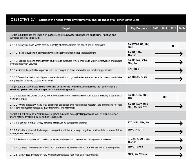
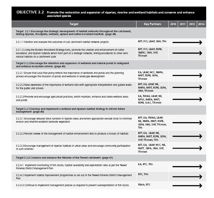
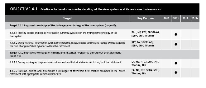
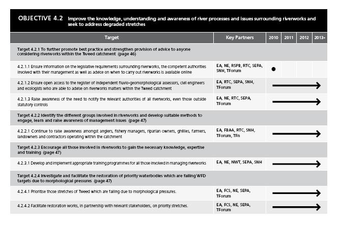
TWEED CATCHMENT MANAGEMENT PLAN Contents
 Contents TWEED CATCHMENT MANAGEMENT PLAN 2015-2021 Executive Summary... 4 Introduction i.i Background...11 i.ii Catchment management planning for Tweed...11 i.iii Development of the Catchment Management
A consultation on the Draft River Basin Management Plan Dee River Basin District
 1 A consultation on the Draft River Basin Management Plan Dee River Basin District December 2008 The Environment Agency works with other regulators and co-deliverers to protect the water environment in
PART 1. To: Scottish Consultation Authorities: PART 2
 PART 1 To: Scottish Consultation Authorities: SEA.gateway@scotland.gsi.gov.uk PART 2 An SEA Screening Report is attached for the plan, programme or strategy (PPS) entitled: Scotland River Basin Management
The Metropolitan Glasgow Strategic Drainage Partnership
 Briefing Note 5 - Spring 2010 The Metropolitan Glasgow Strategic Drainage Partnership The Metropolitan Glasgow Strategic Drainage Partnership (MGSDP) is an innovative and collaborative venture between
Argyll and Lochaber area management plan catchment summaries
 Argyll and Lochaber area management plan catchment summaries Ardnamurchan coastal catchment Introduction Ardnamurchan coastal catchment covers 798 km 2 and extends round the west coast of the Ardnamurchan
Solway-Tweed WFD aquatic monitoring strategy
 Version Comments 1.0 First released version of WFD aquatic monitoring strategy for Solway-Tweed River Basin District Solway-Tweed WFD aquatic monitoring strategy 1.0 Introduction 1.1 Solway Tweed A River
Summary of UKEOF Partners Natural Capital aims, objectives and monitoring activities (June 2016)
") Summary of UKEOF s Natural Capital aims, objectives and monitoring activities (June 2016) s were asked to provide details of their Natural Capital activities: i. ii. delivered and used by the organisation,
Summary of UKEOF s Natural Capital aims, objectives and monitoring activities (June 2016) s were asked to provide details of their Natural Capital activities: i. ii. delivered and used by the organisation,
Renewable Energy A Proven Track Record for Delivering Biodiversity Offsetting development and implementation of an approach in Scottish Borders
 Renewable Energy A Proven Track Record for Delivering Biodiversity Offsetting development and implementation of an approach in Scottish Borders IEEM Conference Renewable Energy and Biodiversity Impacts
River Carron catchment profile
 River Carron catchment profile Introduction From its source in the Campsie Fells, the River Carron drains an area of approximately 192 km 2 before entering the Firth of Forth via the Carron Estuary at
BIODIVERSITY ACTION PLAN
 BIODIVERSITY ACTION PLAN FOR HAMPSHIRE V O L U M E O N E HAMPSHIRE BIODIVERSITY PARTNERSHIP BIODIVERSITY ACTION PLAN FOR HAMPSHIRE VOLUME ONE Compiled by Jacklyn Johnston on behalf of the Hampshire Biodiversity
Site Improvement Plan. Ford Moss SAC. Improvement Programme for England's Natura 2000 Sites (IPENS) Planning for the Future
 Planning for the Future") Improvement Programme for England's Natura 2000 Sites (IPENS) Planning for the Future Site Improvement Plan Ford Moss Site Improvement Plans (SIPs) have been developed for each Natura 2000 site in England
Improvement Programme for England's Natura 2000 Sites (IPENS) Planning for the Future Site Improvement Plan Ford Moss Site Improvement Plans (SIPs) have been developed for each Natura 2000 site in England
Chapter 6 Objective: Protect and Enhance the Environment
 Chapter 6 Objective: Protect and Enhance the Environment 49 Irish Water Water Services Strategic Plan Our Strategic Aims Ensure that Irish Water services are delivered in a sustainable manner which contributes
Don Catchment Vision
 Don Catchment Vision Don Catchment Vision A healthy and biodiverse catchment that is valued and enjoyed, contributing to the economic and social well-being of local communities. Aims for the Don To identify
Cairngorms National Park Partnership Plan Strategic Environmental Assessment Environmental Report Appendix 1: Plans, Policies and
 Cairngorms National Park Partnership Plan 2017-2022 Strategic Assessment Report Appendix 1: Plans, Policies and Strategies June 2016 Appendices Appendix 1: Plans, Policies and Strategies International
MANAGING THE IMPACT OF INVASIVE SPECIES ON SCOTTISH RIVERS. Phil Boon Scottish Natural Heritage, Edinburgh, UK
 MANAGING THE IMPACT OF INVASIVE SPECIES ON SCOTTISH RIVERS Phil Boon Scottish Natural Heritage, Edinburgh, UK APPROACH Managing alien species in Scotland under the Water Framework Directive Exclusively
The Eddleston Water Project - measuring the effectiveness of restoring a sub-catchment of the Tweed
 The Eddleston Water Project - measuring the effectiveness of restoring a sub-catchment of the Tweed 14:00 The Eddleston Water Project: aims & policy context - Chris Spray (University of Dundee) 14:15 Designing
Council CNL(14)40. Annual Progress Report on Actions Taken Under Implementation Plans for the Calendar Year 2013
40. Annual Progress Report on Actions Taken Under Implementation Plans for the Calendar Year 2013") Agenda Item 6.1 For Information Council CNL(14)40 Annual Progress Report on s Taken Under Implementation Plans for the Calendar Year 2013 EU UK (Scotland) (Updated 12 May 2014) This APR was originally
Agenda Item 6.1 For Information Council CNL(14)40 Annual Progress Report on s Taken Under Implementation Plans for the Calendar Year 2013 EU UK (Scotland) (Updated 12 May 2014) This APR was originally
Dr Martin Griffiths 16 February 2016
 Dr Martin Griffiths martin.griffiths@pillon.co.uk 16 February 2016 Outcomes in the Environment - UK 2 utcomes in the Environment - India 3 Integrated Catchment Management - Principles Integrated Catchment
Country report. UK bathing water quality in United Kingdom
 Country report UK bathing water quality in 2015 United Kingdom May 2016 BWD Report For the Bathing Season 2015 The United Kingdom The report gives a general overview of information acquired from the reported
The Water Framework Directive and the catchment based approach in your area
 The Water Framework Directive and the catchment based approach in your area Teresa Brown Catchment Co-ordinator For the Upper and Bedford Ouse, Old Bedford and Middle Level The Water Framework Directive
Water Framework Directive and EIA: our experience. Jo Murphy, MIEMA CEnv MCIM National Environmental Assessment Service (NEAS) 31 May 2012
 31 May 2012") Water Framework Directive and EIA: our experience Jo Murphy, MIEMA CEnv MCIM National Environmental Assessment Service (NEAS) 31 May 2012 The plan Me: Aims & objectives of the Water Framework Directive
Water Framework Directive and EIA: our experience Jo Murphy, MIEMA CEnv MCIM National Environmental Assessment Service (NEAS) 31 May 2012 The plan Me: Aims & objectives of the Water Framework Directive
Climate Change Strategy Tackling Climate Change
 Fife Environmental Partnership Climate Change Strategy 2014-2020 Tackling Climate Change 1 Introduction Climate Change is going to have a dramatic impact on our future. The effects of a changing climate
Statement of Particulars Western Wales Flood Risk Management Plan
 Statement of Particulars Western Wales Flood Risk Management Plan FINAL 22 September 2015 Date Our purpose is to ensure that the natural resources of Wales are sustainably maintained, used and enhanced,
Land Management and Flooding. Where are we now?
 Land Management and Flooding Where are we now? Tarland farmer s workshop Andrea Johnstonova, SEPA The talk will cover Some background information: NFM under the FRM Act Implementation so far and examples
Prestwick and Ayr (Potentially Vulnerable Area 12/09) Local Plan District Ayrshire Local authority South Ayrshire Council Main catchment Doonfoot to M
 Local Plan District Ayrshire Local authority South Ayrshire Council Main catchment Doonfoot to M") Prestwick and Ayr (Potentially Vulnerable Area 12/09) Local Plan District Ayrshire Local authority South Ayrshire Council Main catchment Doonfoot to Monkton coastal Summary of flooding impacts At risk
Prestwick and Ayr (Potentially Vulnerable Area 12/09) Local Plan District Ayrshire Local authority South Ayrshire Council Main catchment Doonfoot to Monkton coastal Summary of flooding impacts At risk
Water Framework Directive*
 Water Framework Directive* Juan-Pablo Pertierra European Commission DG Environment * Directive 2000/60/EC of the European Parliament and of the Council of 23 Oct 2000 establishing a framework for Community
Response from the Institute of Fisheries Management to the Government s A Green Future: Our 25 Year Plan to Improve the Environment
 Response from the Institute of Fisheries Management to the Government s A Green Future: Our 25 Year Plan to Improve the Environment SUMMARY The Institute of Fisheries Management welcomes the Government
Site Improvement Plan. River Kent SAC. Improvement Programme for England's Natura 2000 Sites (IPENS) Planning for the Future
 Planning for the Future") Improvement Programme for England's Natura 2000 Sites (IPENS) Planning for the Future Site Improvement Plan River Kent Site Improvement Plans (SIPs) have been developed for each Natura 2000 site in England
Improvement Programme for England's Natura 2000 Sites (IPENS) Planning for the Future Site Improvement Plan River Kent Site Improvement Plans (SIPs) have been developed for each Natura 2000 site in England
Planning Background Paper. Water Environment. LUPS-BP-GU2b v.1 UNCONTROLLED DOCUMENT WHEN PRINTED Page 1 of 30
 Background Paper Water Environment LUPS-BP-GU2b v.1 UNCONTROLLED DOCUMENT WHEN PRINTED Page 1 of 30 SEPA Background Paper: Water Environment SCOTTISH ENVIRONMENT PROTECTION AGENCY Identifier: LUPS-BP-GU2b
Response to SEPA s Flood Risk Management (Scotland) Act 2009 consultation: Planning for floods planning for the future
 Act 2009 consultation: Planning for floods planning for the future") Response to SEPA s Flood Risk Management (Scotland) Act 2009 consultation: Planning for floods planning for the future by the Scottish Environment LINK Freshwater Taskforce Date: 15 th October 2010 Summary
Response to SEPA s Flood Risk Management (Scotland) Act 2009 consultation: Planning for floods planning for the future by the Scottish Environment LINK Freshwater Taskforce Date: 15 th October 2010 Summary
Tweed Catchment Management Plan Review
 Tweed Catchment Management Plan Review 2005-09 MEMBERS: Borders Forest Trust... BFT Environment Agency...EA Federation of Borders Angling Associations... FBAA Forestry Commission Scotland... FCS Natural
General details. aquifers. Water body identifier code: Area km 2 :
 General details Water body name: Water body identifier code: 150227 Area km 2 : 489.66 Water body category: Baseline: River basin district: Area advisory group: Associated protected areas: Edinburgh and
Improving the River Petteril Online Story Map featuring a case study in catchment management
 Improving the River Petteril Online Story Map featuring a case study in catchment management Summary The Improving the River Petteril story map presents a catchment management case study for the River
Technical Briefing: Water Framework Directive
 Technical Briefing: Water Framework Directive Summary: The Water Framework Directive (WFD) will revolutionise the way that the water environment is managed and protected. It replaces today s piecemeal
Consultation on updating the River Basin Management Plan. River Basin Management Planning Overview Annex. Date
 Consultation on updating the River Basin Management Plan River Basin Management Planning Overview Annex Date 1 Our purpose is to ensure that the natural resources of Wales are sustainably maintained, used
Towards Better Environmental Options for Flood risk management
 Towards Better Environmental Options for Flood risk management Why this initiative? Floods are the most common and most costly natural disasters in Europe. Severe floods with devastating effects happen
Somerset Flood Action Plan Progress Update June, 2014
 Somerset Flood Action Plan Progress Update June, 2014 This is an update on the progress being made on the Levels and Moors Flood Action Plan (FAP). The FAP is coordinated by Somerset County Council but
Rutherglen (Potentially Vulnerable Area 11/14) Local Plan District Clyde and Loch Lomond Local authority Glasgow City Council, South Lanarkshire Counc
 Local Plan District Clyde and Loch Lomond Local authority Glasgow City Council, South Lanarkshire Counc") Rutherglen (Potentially Vulnerable Area 11/14) Local Plan District Clyde and Loch Lomond Local authority Glasgow City Council, South Lanarkshire Council Main catchment Cityford Burn Summary of flooding
Rutherglen (Potentially Vulnerable Area 11/14) Local Plan District Clyde and Loch Lomond Local authority Glasgow City Council, South Lanarkshire Council Main catchment Cityford Burn Summary of flooding
DEFRA WATER STAKEHOLDER FORUM Environment Agency Update on Progress November 2011
 DEFRA WATER STAKEHOLDER FORUM Environment Agency Update on Progress November 2011 Contents Catchment pilots... 2 Current Bathing Waters Directive (cbwd)... 3 Cycle 2 planning... 4 Drinking Water Protected
ANNUAL REVIEW
 ANNUAL REVIEW 2009-2010 1 CHAIRMAN S REPORT Once again flooding was a key issue of the last year. The Cheviots were hit particularly hard in July, and again in September, undoing a lot of the remedial
Chapter 8 Natural Resources
 Chapter 8 Natural Resources 127-134 8.1 Introduction 8.2 Extractives Industry 8.3 Forestry 8.4 Fishing / Aquaculture 8.1 Introduction Kerry has a number of naturally occurring resources that contribute
Current condition and challenges for the future: Scotland river basin district. A public consultation
 Current condition and challenges for the future: Scotland river basin district A public consultation Foreword This consultation provides you with the opportunity to contribute to the development of new
CNL(10)51. NASCO Guidelines for the Protection, Restoration and Enhancement of Atlantic salmon Habitat
51. NASCO Guidelines for the Protection, Restoration and Enhancement of Atlantic salmon Habitat") CNL(10)51 NASCO Guidelines for the Protection, Restoration and Enhancement of Atlantic salmon Habitat 1. Introduction Salmon habitat in freshwater has been greatly affected by various activities, both
CNL(10)51 NASCO Guidelines for the Protection, Restoration and Enhancement of Atlantic salmon Habitat 1. Introduction Salmon habitat in freshwater has been greatly affected by various activities, both
Assessment of Member States progress in the implementation of Programmes of Measures during the first planning cycle of the Water Framework Directive
 Assessment of Member States progress in the implementation of Programmes of Measures during the first planning cycle of the Water Framework Directive Member State Report: United Kingdom (UK) Disclaimer:
Hydromorphology in the Danube River Basin
 Workshop on Transboundary Water Resources Management in Western and Central Europe 8-10 February 2011, Budapest, HU Hydromorphology in the Danube River Basin Raimund MAIR, ICPDR Technical Expert on River
River Forth catchment profile
 River Forth catchment profile Introduction The River Forth catchment encompasses a large area approximately 1029 km 2. As can be seen in Figure 1, the catchment not only contains the River Forth itself,
The Rural Diffuse Pollution Plan for Scotland. Jannette MacDonald Land Unit, SEPA
 The Rural Diffuse Pollution Plan for Scotland Jannette MacDonald Land Unit, SEPA Package of Measures Regulations Guidance and tools Funding Regulations - The Water Environment (Controlled Activities) (Scotland)
Overview of objectives and planning tools emanating from EU environmental legislation
 Overview of objectives and planning tools emanating from EU environmental legislation Unit D1 Land use and management DG Environment European Commission EU Biodiversity Strategy Habitats and Birds Directives
Water Policy and New River Basin Management Plan. Maria Graham 20 June 2018
 Water Policy and New River Basin Management Plan Maria Graham 20 June 2018 Overview Developing the Policy and Plans key building blocks Overview of the RBMP and the WSPS Next steps An Roinn Tithíochta,
BORDER UPLANDS DEMONSTRATOR INITIATIVE
 BORDER UPLANDS DEMONSTRATOR INITIATIVE A partnership Initiative hosted by Northumberland national Park Christine Venus Sarah Kidd christine.venus@naturalengland.org.uk sarah.kidd@northumberland.gov.uk
Site Improvement Plan. South Solway Mosses SAC. Improvement Programme for England's Natura 2000 Sites (IPENS) Planning for the Future
 Planning for the Future") Improvement Programme for England's Natura 2000 Sites (IPENS) Planning for the Future Site Improvement Plan South Solway Mosses Site Improvement Plans (SIPs) have been developed for each Natura 2000 site
Improvement Programme for England's Natura 2000 Sites (IPENS) Planning for the Future Site Improvement Plan South Solway Mosses Site Improvement Plans (SIPs) have been developed for each Natura 2000 site
Cascade Consulting APPENDICES
 APPENDICES APPENDIX A REVIEW OF POLICY, PLANS AND PROGRAMMES The findings of the review of policy, plans and programmes are set out in Table A1. This table sets out the purpose and objectives of the policies,
Levels of evidence for completing investigations and selecting measures
 Levels of evidence for completing investigations and selecting measures Guidance note Issued 23 May 2011 1. Purpose of this guidance note As part of implementing the first river basin management plans,
Oxon Ray Catchment Summary of significant issues affecting the water environment
 Oxon Ray Catchment Summary of significant issues affecting the water environment Introduction This information pack has been produced to support the Challenges and Choices consultation document for the
Flooding and Flood Management Inquiry
 Scottish Environment LINK is the forum for Scotland's voluntary environment organisations representing a broad spectrum of environmental interests with the common goal of contributing to a more environmentally
Irvine to Troon (Potentially Vulnerable Area 12/07) Local Plan District Local authority Main catchment North Ayrshire Council, Ayrshire Monkton to Irv
 Local Plan District Local authority Main catchment North Ayrshire Council, Ayrshire Monkton to Irv") Irvine to Troon (Potentially Vulnerable Area 12/07) Local Plan District Ayrshire Local authority North Ayrshire Council, South Ayrshire Council Main catchment Monkton to Irvine coastal Summary of flooding
Irvine to Troon (Potentially Vulnerable Area 12/07) Local Plan District Ayrshire Local authority North Ayrshire Council, South Ayrshire Council Main catchment Monkton to Irvine coastal Summary of flooding
Copyright United Utilities Water Limited
 Copyright United Utilities Water Limited 2016 1 Contents 1. Aims... 2 2. Background... 2 3. Tracking supply-demand in West Cumbria... 3 4. Contingency plan... 3 5. River Ehen Special Area of Conservation
Dee River Basin Management Plan Summary
 Dee River Basin Management Plan 2015 2021 Summary Updated December 2015 Published by: Cambria House 29 Newport Road Cardiff CF24 0TP 0300 065 3000 (Mon-Fri, 8am - 6pm) enquiries@naturalresourceswales.gov.uk
General details. Water body identifier code: Area km 2 :
 General details Water body name: Water body identifier code: 150218 Area km 2 : 498.82 Water body category: Baseline: River basin district: Area advisory group: Associated protected areas: Clydesdale bedrock
Humber Management Scheme. FAQs Water quality
 Humber Management Scheme FAQs Water quality Key organisations and involvement in EMS management The Water Framework Directive (WFD) sets out how the water environment in England will be managed using a
Mainstreaming WFD objectives into sectoral policies an example of Rural Development Programmes
 Mainstreaming WFD objectives into sectoral policies an example of Rural Development Programmes Josselin Rouillard, Ecologic Institute 25/10/2017 Tackling drivers of loss of aquatic biodiversity H2020 AQUACROSS
Tidal Thames Catchment-based Pilot Project
 Tidal Catchment-based Pilot Project Context The catchment of the Tidal flows from Teddington, in the west, to the estuary near Southend-on-Sea, in the east. The water surface area for this length of the
Argyll and Lochaber area management plan catchment summaries
 Argyll and Lochaber area management plan catchment summaries Island of Mull coastal catchment summary Introduction The Island of Mull coastal catchment covers 883 km 2 and includes all the freshwater on
Diffuse Water Pollution from Rural Land Use Consultation by the Scottish Executive Environmental Group
 Ian Speirs Water Division Scottish Executive Area 1-H, Victoria Quay EDINBURGH EH6 6QQ 10/03/2006 Dear Ian Diffuse Water Pollution from Rural Land Use Consultation by the Scottish Executive Environmental
Regulation of Water Resources Planning in Scotland
 Policy Position Statement Regulation of Water Resources Planning in Scotland Purpose The purpose of this Policy Position Statement (PPS) is to identify the procedures that apply to the planning, the protection,
Getting the best from our land
 Getting the best from our land A Land Use Strategy for Scotland 2016-2021 Laid before the Scottish Parliament by the Scottish Ministers on 22 March 2016 in pursuance of Section 57 of the Climate Change
An Introduction to the EU legislation on water. Title
 An Introduction to the EU legislation on water Subtitle Title Daniel Fernández Gómez Environmental Implementation Unit - E2 DG Environment, European Commission ASSOCIATION OF EUROPEAN ADMINISTRATIVE JUDGES
Water & Agriculture. Seamus Barron Nitrates, Biodiversity & Engineering Division
 Water & Agriculture Seamus Barron Nitrates, Biodiversity & Engineering Division Presentation overview Water Framework Directive Nitrates regulations Support /initiatives for protecting water quality 2
Resolution XI.3. Adjustments to the Strategic Plan for the triennium
 11 th Meeting of the Conference of the Parties to the Convention on Wetlands (Ramsar, Iran, 1971) Wetlands: home and destination Bucharest, Romania, 6-13 July 2012 Resolution XI.3 Adjustments to the Strategic
Draft Business Plan. Part A (extract) Summary of Company Strategy
 Summary of Company Strategy") Draft Business Plan Part A (extract) Summary of Company Strategy Note: The full version of Part A of the Draft Business Plan will be published by 11 August 2008. NORTHUMBRIAN WATER LIMITED: OPERATING AREAS
Draft Business Plan Part A (extract) Summary of Company Strategy Note: The full version of Part A of the Draft Business Plan will be published by 11 August 2008. NORTHUMBRIAN WATER LIMITED: OPERATING AREAS
Scottish Environment Protection Agency
 Scottish Environment Protection Agency Susan MacPherson Senior Environment Protection Officer Stornoway Office The Water Environment (Controlled Activities) (Scotland) Regs 2011 Certain activities in surface
DRAINAGE. Actions for Tomorrow. Drainage. Actions Today
 DRAINAGE The objective of Manitoba s water drainage policies is to enhance the economic viability of Manitoba s agricultural community through the provision of comprehensively planned drainage infrastructure.