Estimating Michigan s Trophic State Trends with Satellite Imagery USGS Recent Inland Lake Studies
|
|
|
- Darcy Bridges
- 6 years ago
- Views:
Transcription


1 Estimating Michigan s Trophic State Trends with Satellite Imagery USGS Recent Inland Lake Studies Lori Fuller USGS Michigan-Ohio Water Science Center 2016 Michigan Inland Lakes Convention April 29, 2016


2 USGS MI-OH Water Science Center


3 USGS MI-OH Water Science Center
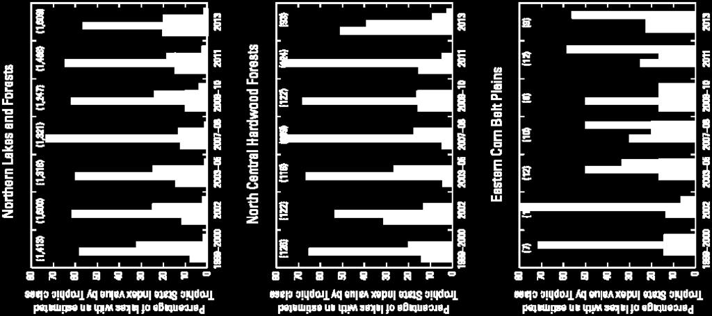
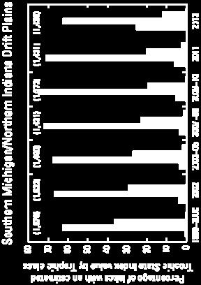
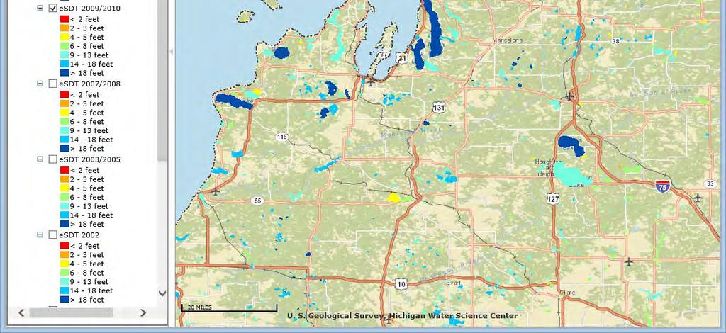
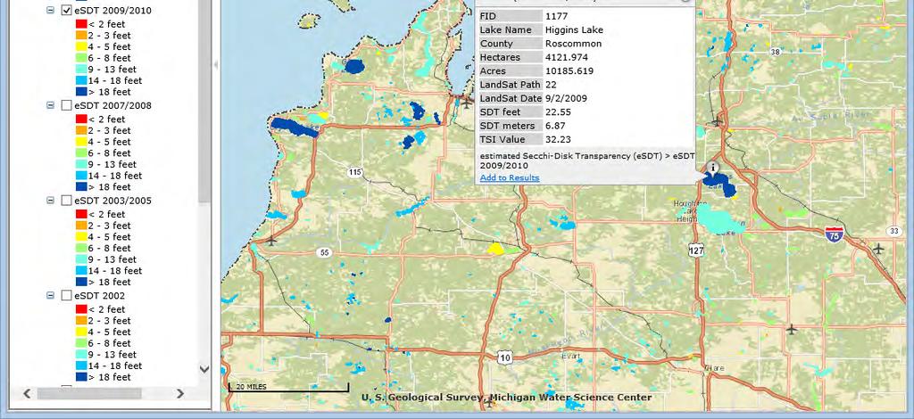
4 Estimation of a Trophic State Index for Selected Inland Lakes in Michigan,
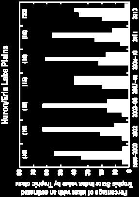
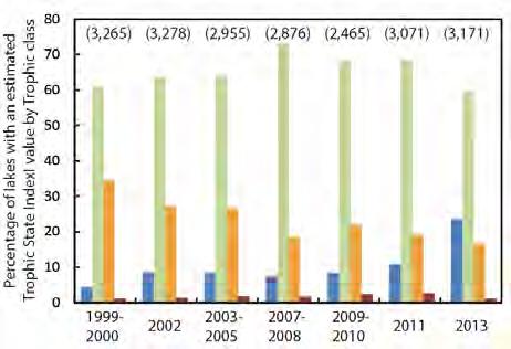
5 Inland Lakes Remote Sensing Regress Secchi-disk transparency (SDT) measurements to Landsat satellite imagery to produce estimated Trophic State Index (TSI) Seven date sets from (3,265 lakes) (3,278 lakes) (3,121 lakes) (3,024 lakes) (2,591 lakes) (3,071 lakes) (3,171 lakes)
6 Background Minnesota Olmanson, L.G., Kloiber, S.M., Bauer, M.E., Brezonik, P.L. (2001). Image Processing Protocol for Regional Assessments of Lake Water Quality. Water Resources Center and Remote Sensing Laboratory, University of Minnesota. Wisconsin Chipman, J. W., T. M. Lillesand, J. E. Schmaltz, J. E. Leale, and M. J. Nordheim. (2004). Mapping Lake Water Clarity with Landsat Images in Wisconsin, USA. Invited paper, Canadian Journal of Remote Sensing, Special Issue on Remote Sensing and Resource Management in Nearshore & Inland Waters, 30(1):1-7. Michigan Nelson, S.A.C., Soranno, P.A., Cheruvelil, K.S., Batzli, S.A., Skole, D.L. (2002). Assessing regional lake water clarity using Landsat and the role of inter-lake variability pdf Wiangwang, N. (2002). Water Clarity/Trophic condition monitoring by using satellite remote sensing data. Masters paper, Department of Geography Graduate Program, Michigan State University, MI.
7 Program potential for Michigan The State of Michigan has ~ 4,000 inland lakes greater than 20 acres. Measurements Cooperative Lakes Monitoring Program (MDEQ & ML&SA) Each year ~250 inland lakes are sampled by the volunteer program Weekly sampling Wisconsin Department of Natural Resources Surface Water Integrated Monitoring System Database Assist in western U.P. of Michigan Satellite Imagery Landsat 5 ( ) Landsat 7 (1999 Present (2016)) Landsat 8 (2013 Present (2016))
 30-meter cells 16 day")


8 Landsat satellite imagery (5, 7, and 8) 30-meter cells 16 day repeat cycle Choose/process Imagery Late summer July-September Select lakes 20+ acres Mask out non-water Clouds/shadows/haze Shallow/shoreline Dense vegetation Number of 30-meter cells Methods

9 Landsat Satellite Scene Locations
10 Methods Field-measurements of SDT within +/- 10 days of the Landsat satellite imagery acquisition date, though +/- 3 days is preferable 1 measurement per lake in the deepest basin produce a regression model specific to each path and date of Landsat satellite imagery End results are estimated Trophic State Index (etsi) values for open-water areas of inland lakes larger than 20 acres
11 Trophic State Index Traditionally, water quality is indicated by its Trophic State Index (TSI) value TSI can be calculated based on measures of: Total Phosphorus (TP) Chlorophyll-a (Chl-a) Secchi Disk Transparency (SDT) Lake trophic condition TSI value SDT (ft) Chy-a (µg/l) TP (µg/l) Oligotrophic < 38 > 15 < 2.2 < 10 Mesotrophic Eutrophic Hypereutrophic > 61 < 3 > 22 > 50


12 Secchi Disk Transparency High SDT Low TSI Oligotrophic Mid SDT Mid TSI Mesotrophic Low SDT High TSI Eutrophic/ Hypereutrophic Minnesota Pollution Control Agency


13 CLMP Newsletter
 Lansing 64.76923 41.38462 30.46154 2.12626 10.0 3.0480 1.")
14 Regressing SDT to Satellite Imagery ln(sdtm) = a(band1/3) + b(band1) + c LakeName Band 1 Band 2 Band 3 B1/B3 SDT ft SDT m ln(sdtm) Lansing
15 Regression Equations
16 Table 3. Landsat-image and calibration-model data for Estimated Trophic State Index (etsi), Michigan inland lakes, [SDT, secchi-disk transparency; m, meter; ft, feet, R 2, coefficient of determination; SEE, Standard Error of Estimate; TM, Thematic Mapper; x, etsi; B, Landsat satellite band number] Image date Path Rows Number of images used in Path Satellite Days Prior Days Past Number of measurements SDT range(m) SDT range(ft) R 2 SEE Equation: Estimated TSI 7/17/ Landsat TM x = B1/B3(2.4709) + B1( ) /30/ Landsat TM x = B1/B3(1.0250) + B1( ) /24/ Landsat TM x = B1/B3(1.0489) + B1( ) /22/ Landsat TM x = B1/B3(3.5069) + B1(0.1356) /29/ Landsat TM x = B1/B3(1.6309) + B1(0.0468) Estimated TSI 9/1/ Landsat TM x = B1/B3(0.7484) + B1( ) /8/ Landsat TM x = B1/B3(1.6781) + B1(0.0301) /13/ Landsat TM x = B1/B3(1.2221) + B1(0.0236) /30/ Landsat TM x = B1/B3(1.5958) + B1(0.0535) /11/ Landsat TM x = B1/B3(1.5083) + B1(0.0492) /4/ Landsat TM x = B1/B3(1.4881) + B1( ) Estimated TSI 9/22/ Landsat TM x = B1/B3(1.6413) + B1( ) /13/ Landsat TM x = B1/B3(1.3398) + B1(0.0104) /20/ Landsat TM x = B1/B3(0.8592) + B1( ) /21/ Landsat TM x = B1/B3(1.1798) + B1(0.1401) /19/ Landsat TM x = B1/B3(0.7688) + B1(0.1562) /22/ Landsat TM x = B1/B3(1.1529) + B1(0.0945) R 2 - statistic with information about the goodness of fit of a model. A measure of how well the regression line approximates the real data points.
17
18 TSI
19
20 Tukey s Test
21 Statistical Summary Table

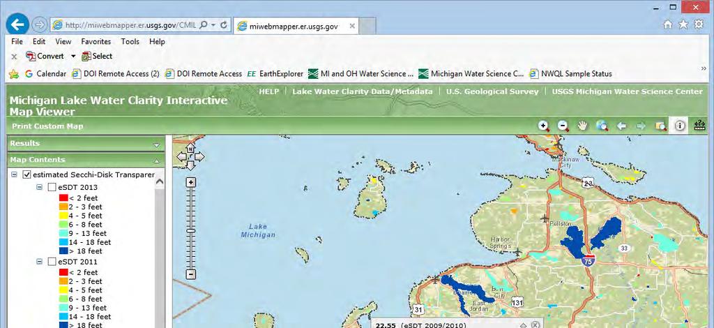
22 USGS Project Webpage
23
24 Landsat 8 Future Satellites Additional bands to detect more gradations in light intensity, and added band to pick up on dark blues ESA Sentinel-2 water quality parameters such as the surface concentration of chlorophyll, detect harmful algal blooms, and measure turbidity (or water clarity)
25 Future Satellites USGS & NASA European Space Agency (ESA) Satellite Landsat Sentinel - 2 Swath width 185 km 290 km Resolution 30 (60) m 10 (20, 60) m Repeat cycle days (1 sat), 5 days (2 sat) ESA Sentinel-2 Smaller lakes Repeat cycle Bands Landsat 5&7 Landsat 8 Sentinel - 2 Blue Red

26 Spectral Band Comparison


27 Silver Lake Nutrient Loading Study, Oceana Co., MI Angela Brennan, Christopher Hoard, and Joseph Duris USGS-MI-OH Water Science Center & GVSU-AWRI In cooperation with the Silver Lake Improvement Board U.S. Department of the Interior U.S. Geological Survey


28 Project Problem In 2011, Progressive AE published the Silver Lake 2011 Water Quality Monitoring Report Study results indicated Silver Lake appeared to be undergoing more accelerated eutrophication and if the trend continued, that there would be more frequent and prolonged algal blooms, reduced transparency, and a decline in overall water quality.
 limiting algal growth in Silver Lake Present model scenarios of future lake conditions in response to changes in nutrient")
29 Project Objectives Describe current water quality in the lake, groundwater, tributaries, and atmosphere Quantify the water and nutrient budgets for Silver Lake and estimate the contribution of septic systems Identify the nutrient(s) limiting algal growth in Silver Lake Present model scenarios of future lake conditions in response to changes in nutrient loading inputs

30 Silver Lake, Oceana County, MI
 5 monitoring locations on lake - 3 second study yr Water temp, DO, Conductivity, ph Secchi disc transparency Chlorophyll-a, phytoplankton, N, P (surface &")
31 Approach Monitor surface water flow & establish a water budget Water chemistry: Monitoring lake and stream chemistry 4 times per year for 2 years, plus 2-3 storm events (annually) 5 monitoring locations on lake - 3 second study yr Water temp, DO, Conductivity, ph Secchi disc transparency Chlorophyll-a, phytoplankton, N, P (surface & bottom)
 North end of lake, used to drain low-lying properties adjacent to the")
32 Approach Monitor groundwater influence 4 wells, measure GW levels & nutrient chemistry for 2 years (North, South, East, & West) Measure 10 private wells to supplement groundwater flow data Observe groundwater flow by installing seepage meters Measure drainage tiles for N & P (38 tiles) North end of lake, used to drain low-lying properties adjacent to the lake
 Nutrient inputs from lawn runoff and waterfowl Estimated from previously published literature")
33 Approach Precipitation Wet (rain and snow) & dry (several days following no precip) samples to determine nutrient deposition (N and P) Nutrient inputs from lawn runoff and waterfowl Estimated from previously published literature values
 Internal nutrient loading estimates (AWRI), determine flux of P & N from")
34 Approach Identify nutrient controlling algal blooms (AWRI) Nutrient bioassay, algal ID (cyanotoxins) Internal nutrient loading estimates (AWRI), determine flux of P & N from sediments

35 Project results Trophic Status Trophic status of Silver Lake, Oceana County, Michigan, based on Carlson s Trophic State Index. (TSI, trophic state index; less than 40 represents oligotrophic conditions, mesotrophic, greater than 50 represents eutrophic conditions).

36 Project results Concluded that internal loading is not a major source of P to Silver Lake Algal growth appears to be co-limited by P and N Cyanotoxin levels are not an issue to date

37 Project Results Nutrient Loading

38 Predicting future lake conditions Nutrient adjustment scenarios of phosphorus and nitrogen to Silver Lake were processed using the BATHTUB model.

39 USGS Scientific Investigations Report Prepared in cooperation with the Silver Lake Improvement Board Angela K. Brennan, Christopher J. Hoard, Joseph W. Duris, Mary E. Ogdahl, and Alan D. Steinman publication/sir


40 Contact Info: Angela Brennan, Hydrologist USGS MI-OH Water Science Center, Lansing, MI Thank you! (517)
USGS LAKE STUDIES CASE STUDY: SILVER LAKE (OCEANA COUNTY, MI) Angela Brennan, Hydrologist - US Geological Survey Upper Midwest Water Science Center,
 Angela Brennan, Hydrologist - US Geological Survey Upper Midwest Water Science Center,") USGS LAKE STUDIES CASE STUDY: SILVER LAKE (OCEANA COUNTY, MI) Angela Brennan, Hydrologist - US Geological Survey Upper Midwest Water Science Center, Lansing, MI October 18, 2017 USGS Inland lake studies
USGS LAKE STUDIES CASE STUDY: SILVER LAKE (OCEANA COUNTY, MI) Angela Brennan, Hydrologist - US Geological Survey Upper Midwest Water Science Center, Lansing, MI October 18, 2017 USGS Inland lake studies
Assessing Lake Clarity...from SPACE...
 Assessing Lake Clarity...from SPACE... Taylor Long Peter Marinello December 10, 2012 Why look at lakes from space?... Lake Clarity Indicative of Water Quality Monitoring time consuming and expensive Satellite
Date: August 16, Upper South Long Lake Association c/o: Dan Martonik 9999 Leisure Lane Brainerd, MN 56401
 Date: August 16, 2011 To: Upper South Long Lake Association c/o: Dan Martonik 9999 Leisure Lane Brainerd, MN 56401 Subject: 2011 Trophic Status Index Mapping Flight Report From: Alan Cibuzar Sarah Fogderud
Balsam Lake Water Quality Study
 Balsam Lake Water Quality Study Prepared for Balsam Lake Protection and Rehabilitation District June 2011 Balsam Lake Water Quality Study Prepared for Balsam Lake Protection and Rehabilitation District
Understanding Lake Data
 Understanding Lake Data Moriya Rufer Environmental Services Director moriya.rufer@rmbel.info Ellie Kriese Lakes Program Coordinator ellie.kriese@rmbel.info Why We re Here Take Homes Learn how to access
Portage Lake CASS COUNTY
 Portage Lake 11-0204-00 CASS COUNTY Summary Portage Lake is located near Bena, MN in Cass County. It covers 1,539 acres, which places it in the upper 10% of lakes in Minnesota in terms of size. Portage
Interpreting Lake Data
 Interpreting Lake Data Indiana Clean Lakes Program The Indiana Clean Lakes Program was created in 1989 as a program within the Indiana Department of Environmental Management's (IDEM) Office of Water Management.
Hydrology: Sources of Water and Nutrients
 Hydrology: Sources of Water and Nutrients 37 Hydrology: Sources of Water and Nutrients Study results indicate that Silver Lake is colimited by both phosphorus and nitrogen, at the time when the bioassay
Interpreting Lake Data
 Interpreting Lake Data Indiana Clean Lakes Program The Indiana Clean Lakes Program was created in 1989 as a program within the Indiana Department of Environmental Management's (IDEM) Office of Water Management.
2017 Data Report for Silver Lake, Van Buren County
 Michigan Lakes Ours to Protect 2017 Data Report for Silver Lake, Van Buren County Site ID: 800534 42.3891 N, 86.0599 W The CLMP is brought to you by: 1 About this report: This report is a summary of the
2016 Summit Lake Water Quality Report Prepared by Thurston County Environmental Health Division
 ! 216 Summit Lake Water Quality Report Prepared by Thurston County Environmental Health Division PART OF TOTTEN INLET WATERSHED LENGTH OF LAKE: 2.2 miles SHORELINE LENGTH: 5.6 miles LAKE SIZE: 53 acres
(This is a sample cover image for this issue. The actual cover is not yet available at this time.)
") (This is a sample cover image for this issue. The actual cover is not yet available at this time.) This article appeared in a journal published by Elsevier. The attached copy is furnished to the author
(This is a sample cover image for this issue. The actual cover is not yet available at this time.) This article appeared in a journal published by Elsevier. The attached copy is furnished to the author
CLMP+ Report on Grass Lake (Anoka County) Lake ID# CLMP+ Data Summary
 Lake ID# CLMP+ Data Summary") CLMP+ Report on Grass Lake (Anoka County) Lake ID# 02-0113-00 2012-2013 CLMP+ Data Summary October 2014 Authors Shannon Martin, MPCA Editing and graphic design Public Information Office Staff The (MPCA)
CLMP+ Report on Grass Lake (Anoka County) Lake ID# 02-0113-00 2012-2013 CLMP+ Data Summary October 2014 Authors Shannon Martin, MPCA Editing and graphic design Public Information Office Staff The (MPCA)
2017 Data Report for Loon Lake, Iosco County
 Michigan Lakes Ours to Protect 2017 Data Report for Loon Lake, Iosco County Site ID: 350078 The CLMP is brought to you by: 1 About this report: This report is a summary of the data that have been collected
2018 Data Report for Pickerel Lake, Kalkaska County
 Michigan Lakes Ours to Protect 2018 Data Report for Pickerel Lake, Kalkaska County Site ID: 400035 44.800559 N, 84.97667 W The CLMP is brought to you by: 1 About this report: This report is a summary of
2017 Data Report for Portage Lake, Washtenaw County
 Michigan Lakes Ours to Protect 2017 Data Report for Portage Lake, Washtenaw County Site ID: 810248 42.420559 N, 83.921392 W The CLMP is brought to you by: 1 About this report: This report is a summary
Remote Sensing of Inland Lake Harmful Algal Blooms
 Remote Sensing of Inland Lake Harmful Algal Blooms Linda Novitski Cooperative Institute for Limnology and Ecosystems Research Ann Arbor, Michigan May 2, 2014 Talk Outline Introduction to harmful algal
2018 Data Report for. Crystal Lake, Montcalm County
 Michigan Lakes Ours to Protect 218 Data Report for Crystal Lake, Montcalm County Site ID: 5915 43.25584 N, 84.93362 W The CLMP is brought to you by: 1 About this report: This report is a summary of the
Remote Sensing of Water Quality in Wisconsin
 Remote Sensing of Water Quality in Wisconsin 1 Steve Greb, UW-Madison Daniela Gurlin, WDNR ----------------------------------- Wisconsin Lakes Convention April 19 th, 218 MODIS Today website are acquired
Phosphorus Goal Setting Process Questions and Answers 2010
 Lake Winnipesaukee Watershed Management Plan Phase I: Meredith, Paugus, Saunders Bays 1. What is phosphorus? Phosphorus (P) is a naturally occurring element and a major nutrient required for biological
2017 Data Report for Shingle Lake, Clare County
 Michigan Lakes Ours to Protect 217 Data Report for Shingle Lake, Clare County Site ID: 1818 43.96359 N, 84.95282 W The CLMP is brought to you by: 1 About this report: This report is a summary of the data
Detection of Spatial and Temporal Trends in Wisconsin Lake Water Clarity Using Landsatderived Estimates of Secchi Depth
 Lake and Reservoir Management ISSN: 1040-2381 (Print) 2151-5530 (Online) Journal homepage: http://www.tandfonline.com/loi/ulrm20 Detection of Spatial and Temporal Trends in Wisconsin Lake Water Clarity
2017 Data Report for Lake Tahoe, Oceana County
 Michigan Lakes Ours to Protect 17 Data Report for Lake Tahoe, Oceana County Site ID: 33 3.1 N,.3 W The CLMP is brought to you by: 1 About this report: This report is a summary of the data that have been
2017 Data Report for Perch Lake, Iron County
 Michigan Lakes Ours to Protect 217 Data Report for Perch Lake, Iron County Site ID: 3646 46.361392 N, 88.658338 W The CLMP is brought to you by: 1 About this report: This report is a summary of the data
CLMP+ Report on Fleming Lake (Aitkin County)
") CLMP+ Report on Fleming Lake (Aitkin County) Lake ID# -5-5-6 CLMP+ Data Summary July 7 Authors Shannon Martin Contributors/acknowledgements Terry Dahlberg Sandy Dahlberg Pam Anderson For questions regarding
CLMP+ Report on Fleming Lake (Aitkin County) Lake ID# -5-5-6 CLMP+ Data Summary July 7 Authors Shannon Martin Contributors/acknowledgements Terry Dahlberg Sandy Dahlberg Pam Anderson For questions regarding
2017 Data Report for Earl Lake, Livingston County
 Michigan Lakes Ours to Protect 217 Data Report for Earl Lake, Livingston County Site ID: 755 2.191 N, 3.95 W The CLMP is brought to you by: 1 About this report: This report is a summary of the data that
2017 Data Report for Painter Lake, Cass County
 Michigan Lakes Ours to Protect 217 Data Report for Painter Lake, Cass County Site ID: 1418 41.81667 N, 85.99194 W The CLMP is brought to you by: 1 About this report: This report is a summary of the data
2017 Data Report for Big Maggie Lake, Iron County
 Michigan Lakes Ours to Protect 2017 Data Report for Big Maggie Lake, Iron County Site ID: 360173 46.01 N, 88.4626 W The CLMP is brought to you by: 1 About this report: This report is a summary of the data
2017 Data Report for Fern Lake, Grand Traverse County
 Michigan Lakes Ours to Protect 2017 Data Report for Site ID: 280438 44.73475 N, 85.73409 W The CLMP is brought to you by: 1 About this report: This report is a summary of the data that have been collected
2017 Data Report for Arbutus Lake, Grand Traverse County
 Michigan Lakes Ours to Protect 217 Data Report for Arbutus Lake, Grand Traverse County Site ID: 2819 44.65917 N, 85.519726 W The CLMP is brought to you by: 1 About this report: This report is a summary
2017 Data Report for Ottawa Lake, Iron County
 Michigan Lakes Ours to Protect 2017 Data Report for Site ID: 360033 46.08484 N, 88.76419 W The CLMP is brought to you by: 1 About this report: This report is a summary of the data that have been collected
2017 Data Report for Deer Lake, Alger County
 Michigan Lakes Ours to Protect 2017 Data Report for Deer Lake, Alger County Site ID: 020127 46.48016 N, 86.98277 W The CLMP is brought to you by: 1 About this report: This report is a summary of the data
2017 Data Report for Pleasant Lake, Wexford County
 Michigan Lakes Ours to Protect 2017 Data Report for Pleasant Lake, Wexford County Site ID: 830183 44.3 N, 85.4775 W The CLMP is brought to you by: 1 About this report: This report is a summary of the data
2017 Data Report for Oxbow Lake, Oakland County
 Michigan Lakes Ours to Protect 2017 Data Report for Oxbow Lake, Oakland County Site ID: 630666 42.64167 N, 83.477226 W The CLMP is brought to you by: 1 About this report: This report is a summary of the
Portage Lake Hubbard County
 Prepared in cooperation with the Minnesota Department of Natural Resources Minnesota Lake ID: 9- Area: acres Watershed Area: 6,7 acres Ecoregion: Northern Lakes and Forests (NLF) Portage Lake Hubbard County
Envirothon Aquatics. Mike Archer, NE Dept. of Environmental Quality. Katie Pekarek, Nebraska Extension Jeff Blaser, Nebraska Game and Parks
 Envirothon Aquatics Mike Archer, NE Dept. of Environmental Quality Katie Pekarek, Nebraska Extension Jeff Blaser, Nebraska Game and Parks Lake Watersheds Watershed = area contributing water to pond Surface
2017 Data Report for Little Paw Paw Lake, Berrien County
 Michigan Lakes Ours to Protect 2017 Data Report for Site ID: 110765 42.21899 N, 86.29072 W The CLMP is brought to you by: 1 About this report: This report is a summary of the data that have been collected
Lake Washington. Water Quality Assessment Report. Copyright 2012 PLM Lake & Land Management Corp.
 Lake Washington 2012 Water Quality Assessment Report Copyright 2012 PLM Lake & Land Management Corp. Water Quality Report On May 22nd, June 18th, July 30th, August 29th, and September 27 th, 2012, PLM
Remote Estimation of Regional Lake Clarity with Landsat TM and MODIS Satellite Imagery
 The University of Maine DigitalCommons@UMaine Electronic Theses and Dissertations Fogler Library 5-2012 Remote Estimation of Regional Lake Clarity with Landsat TM and MODIS Satellite Imagery Ian M. McCullough
2017 Data Report for Hoags Lake, Mason County
 Michigan Lakes Ours to Protect 17 Data Report for Hoags Lake, Mason County.171 N,.19575 W The CLMP is brought to you by: 1 About this report: This report is a summary of the data that have been collected
EUTROPHICATION. Student Lab Workbook
 EUTROPHICATION Student Lab Workbook THE SCIENTIFIC METHOD 1. Research Background literature research about a topic of interest 2. Identification of a problem Determine a problem (with regards to the topic)
2017 Data Report for Rogers Pond, Mecosta County
 Michigan Lakes Ours to Protect 2017 Data Report for 43.6175478 N, 85.4718313 W The CLMP is brought to you by: 1 About this report: This report is a summary of the data that have been collected through
2018 Data Report for. Lotus Lake, Oakland County
 Michigan Lakes Ours to Protect 218 Data Report for Lotus Lake, Oakland County 42.6941 N, 83.4244 W The CLMP is brought to you by: 1 About this report: This report is a summary of the data that have been
Monitoring Lake Simcoe Water Clarity Using Landsat-5 TM Images
 Water Resour Manage (2011) 25:2015 2033 DOI 10.1007/s11269-011-9792-3 Monitoring Lake Simcoe Water Clarity Using Landsat-5 TM Images Xian Guan Jonathan Li William G. Booty Received: 31 May 2010 / Accepted:
Boy Lake CASS COUNTY
 Boy Lake 11-143- CASS COUNTY Summary Boy Lake is located near Remer, MN in Cass County. It covers 3,452 acres, which places it in the upper 1% of lakes in Minnesota in terms of size. Boy Lake has two main
2014 Data Report for Higgins Lake, Roscommon County North Basin
 214 Data Report for Higgins Lake, Roscommon County North Basin Michigan Lakes Ours to Protect The CLMP is brought to you by: About this report: This report is a summary of the data that have been collected
2017 Data Report for Duck Lake, Muskegon County
 Michigan Lakes Ours to Protect 217 Data Report for Duck Lake, Muskegon County Site ID: 61778 43.33785 N, 86.39258 W The CLMP is brought to you by: 1 About this report: This report is a summary of the data
Long-Term Volunteer Lake Monitoring in the Upper Woonasquatucket Watershed
 Long-Term Volunteer Lake Monitoring in the Upper Woonasquatucket Watershed Linda Green URI Watershed Watch 1-87-95, lgreen@uri.edu WATER QUALITY IS A REFLECTION OF THE ACTIVITIES IN THE LANDS AND WATERS
2014 Data Report for Freska Lake, Kent County
 214 Data Report for Freska Lake, Kent County Michigan Lakes Ours to Protect The CLMP is brought to you by: About this report: This report is a summary of the data that have been collected through the Cooperative
Ploof s Creek South. Johannes Creek. Grand Lake, Ploof s Creek South, Johannes Creek. Introduction
 524 4th Street South Sauk Centre, MN 56378 320.352.2231 Grand Lake, Ploof s Creek South, Johannes Creek Introduction Since the 2012 monitoring season, the Grand Lake Improvement District (Grand LID) and
Appendix A. General Concepts in Lake Water Quality. Black Dog WMO Watershed Management Plan P:\23\19\513\plan\Black Dog WMO adopted plan.
 Appendix A General Concepts in Lake Water Quality Black Dog WMO Watershed Management Plan P:\23\19\513\plan\Black Dog WMO adopted plan.doc General Concepts in Lake Water Quality There are a number of concepts
(This is a sample cover image for this issue. The actual cover is not yet available at this time.)
") (This is a sample cover image for this issue. The actual cover is not yet available at this time.) This article appeared in a journal published by Elsevier. The attached copy is furnished to the author
(This is a sample cover image for this issue. The actual cover is not yet available at this time.) This article appeared in a journal published by Elsevier. The attached copy is furnished to the author
U.S. Geological Survey s Update on the Water Quality of Delavan Lake
 Memo to: Town of Delavan Lake Committee Date: February 2, 2013 From: Ryan Simons, Town of Delavan Lake Committee Chairman Subject: U.S. Geological Survey s Update on the Water Quality of Delavan Lake On
Gull Lake CASS & CROW WING COUNTIES
 Gull Lake 11-0305-00 CASS & CROW WING COUNTIES Summary Gull Lake is located just northwest of Brainerd, Minnesota, on the border of Cass and Crow Wing Counties. It covers 9,947 acres, which places it in
Hydrology, Water Quality, and Phosphorus Loading of Little St. Germain Lake, Vilas County, Wisconsin
 Hydrology, Water Quality, and Phosphorus Loading of Little St. Germain Lake, Vilas County, Wisconsin Introduction Little St. Germain Lake, which is in Vilas County, Wisconsin, just northeast of St. Germain
2017 Data Report for Klinger Lake, St. Joseph County
 Michigan Lakes Ours to Protect 217 Data Report for Klinger Lake, St. Joseph County Site ID: 75136 41.82781 N, 85.543893 W The CLMP is brought to you by: 1 About this report: This report is a summary of
Okanagan Large Lakes Water Quality Monitoring Program Ellison Lake Wood Lake Kalamalka Lake Okanagan Lake Skaha Lake Osoyoos Lake
 Okanagan Large Lakes Water Quality Monitoring Program Ellison Lake Wood Lake Kalamalka Lake Okanagan Lake Skaha Lake Osoyoos Lake 1 Table of Contents Goals & Objectives... Trophic Status... Data Collection...
2016 Data Report for Magician Lake, Cass County
 Michigan Lakes Ours to Protect 216 Data Report for Magician Lake, Cass County Site ID: 1465 42.649 N, 86.179 W The CLMP is brought to you by: 1 About this report: This report is a summary of the data that
2017 Data Report for Lake Independence, Marquette County
 Michigan Lakes Ours to Protect 217 Data Report for Lake Independence, Marquette County Site ID: 2149 46.88337 N, 87.711393 W The CLMP is brought to you by: 1 About this report: This report is a summary
2016 Data Report for Iron Lake, Iron County
 Michigan Lakes Ours to Protect Data Report for Iron Lake, Iron County.1397 N,.533 W The CLMP is brought to you by: 1 About this report: This report is a summary of the data that have been collected through
2016 Data Report for Bruin Lake, Washtenaw County
 Michigan Lakes Ours to Protect 1 Data Report for Bruin Lake, Washtenaw County Site ID: 8575.189788 N, 8.39387 W The CLMP is brought to you by: 1 About this report: This report is a summary of the data
Lake Voorheis, Oakland County
 214 Data Report for Lake Voorheis, Oakland County Michigan Lakes Ours to Protect The CLMP is brought to you by: About this report: This report is a summary of the data that have been collected through
2017 Water Quality Report and Historical Analysis. Long Lake Mickey Lake Ruth Lake. Monitoring Years
 2017 Water Quality Report and Historical Analysis Long Lake Mickey Lake Ruth Lake Monitoring Years 1993-2017 Submitted to: Long Lake Association October 2017 Prepared by: Great Lakes Environmental Center
CHEC Punta Gorda Canal Water Quality Sampling Program
 CHEC Punta Gorda Canal Water Quality Sampling Program Charlotte Harbor Environmental Center Canal Water Sampling Program Initiated 2009 Six Canal locations are sampled Monthly sampling by volunteers Lake
Stormwater, Climate Change, and Michigan: Part II. Alan Steinman Director, Annis Water Resources Institute Grand Valley State University
 Stormwater, Climate Change, and Michigan: Part II Alan Steinman Director, Annis Water Resources Institute Grand Valley State University Point vs. Nonpoint Source Pollution Point sources: Nutrients come
Hadlock Pond, Washington Co., Lake Hadlock Association, Inc.
 Hadlock Pond, Washington Co., Lake Hadlock Association, Inc. Lake Characteristics Watershed Characteristics Surface Area (ac/ha) Max Depth (ft/m) Mean Depth (ft/m) Retention Time (years) Water Class Dam
Silver Lake Watershed Management Plan. F. X. Browne, Inc.
 Silver Lake Watershed Management Plan F. X. Browne, Inc. Eutrophication Trophic means food or energy level Oligotrophic ecologically young lake with low nutrients, low populations of algae and macrophytes
Monitoring and Evaluation
 Monitoring and Evaluation The true test of the efficacy of this watershed management plan will be the implementation of the plan goals and objectives. Implementation of watershed plan goals and objectives
What s Happening in Lake Whatcom?
 What s Happening in Lake Whatcom? Dr. Robin A. Matthews, Director Institute for Watershed Studies Huxley College of the Environment Western Washington University June 6, 2011 Site 2 Basin 2 Lake Whatcom
Nutrient Issues in Lake Ontario. Lisa Trevisan Ontario Ministry of the Environment and Climate Change
 Nutrient Issues in Lake Ontario Lisa Trevisan Ontario Ministry of the Environment and Climate Change March 26, 2015 Outline Lake Ontario facts and figures Nutrient stressors in Lake Ontario Cyanobacteria
CHEC Punta Gorda Canal Water Quality Sampling Program
 CHEC Punta Gorda Canal Water Quality Sampling Program Charlotte Harbor Environmental Center Canal Water Sampling Program Initiated 2009 Six Canal locations are sampled Monthly sampling by volunteers Lake
Water Quality Assessment of Select Lakes within the Little Fork River Watershed
 Water Quality Assessment of Select Lakes within the Little Fork River Watershed Rainy River Basin St. Louis, Itasca, and Koochiching Counties, Minnesota Minnesota Pollution Control Agency Water Monitoring
Big Chetac Lake Getting Rid of the Green Phase 3. Nutrient Budget and Management Data Analysis Report
 Big Chetac Lake Getting Rid of the Green Phase 3 Nutrient Budget and Management Data Analysis Report Prepared for: Big Chetac Chain Lake Association and Wisconsin Department of Natural Resources Prepared
2017 Data Report for Spider Lake, Grand Traverse County
 Michigan Lakes Ours to Protect 217 Data Report for Spider Lake, Grand Traverse County Site ID: 28395 44.675987 N, 85.49947 W The CLMP is brought to you by: 1 About this report: This report is a summary
Water Quality and Hydrology of Silver Lake, Oceana County, Michigan, with Emphasis on Lake Response to Nutrient Loading,
 Prepared in cooperation with the Silver Lake Improvement Board Water Quality and Hydrology of Silver Lake, Oceana County, Michigan, with Emphasis on Lake Response to Nutrient Loading, 2012 14 Scientific
2016 Monitoring Report; Mississippi River Tributaries
 2016 Monitoring Report; Mississippi River Tributaries SWWD s East Mississippi watershed (Map 1) is named after the former East Mississippi Watershed Management Organization which managed the area prior
Eutrophication, water clarity, and divergent responses to variation in lake level
 Eutrophication, water clarity, and divergent responses to variation in lake level Peter Lisi post doctoral scientist UW Center for Limnology pjlisi@uw.edu Catherine Hein Wisconsin DNR PJL6 PJL7 Distance
Chapter 2: Conditions in the Spring Lake Watershed related to Stormwater Pollution
 Chapter 2: Conditions in the Spring Lake Watershed related to Stormwater Pollution To identify the primary causes and consequences of stormwater discharges to Spring Lake and its adjoining waterbodies,
Developing Landsat Based Algorithms To Augment In Situ Monitoring Of Freshwater Lakes And Reservoirs
 City University of New York (CUNY) CUNY Academic Works International Conference on Hydroinformatics 8-1-2014 Developing Landsat Based Algorithms To Augment In Situ Monitoring Of Freshwater Lakes And Reservoirs
2015 Data Report for South Torch Lake, Antrim County
 Michigan Lakes Ours to Protect 2015 Data Report for South Torch Lake, Antrim County Site ID: 050240 44.91590 N, 85.30280 W The CLMP is brought to you by: About this report: This report is a summary of
2007 Inland and Purdy Reservoirs Report. Rivers and Reservoirs Monitoring Program
 2007 Inland and Purdy Reservoirs Report Rivers and Reservoirs Monitoring Program Field Operations Division Environmental Indicators Section Aquatic Assessment Unit June 2012 Rivers and Reservoirs Monitoring
Narrative Water Quality Objective
 Narrative Water Quality Objective Waste discharges shall not contribute to excessive algal growth in inland surface receiving waters. (Basin Plan, 1995, pg. 4-5) Excessive is not defined No numeric standard
2016 Data Report for Barlow Lake, Barry County
 Michigan Lakes Ours to Protect 216 Data Report for Barlow Lake, Barry County Site ID: 8176 42.67559 N, 85.5242 W The CLMP is brought to you by: 1 About this report: This report is a summary of the data
The Lake Partner Program
 The Lake Partner Program Anna DeSellas Scientist, Inland Lakes Monitoring & Lake Partner Program Coordinator Dorset Environmental Science Centre 1 Phosphorus and water quality Phosphorus: A nutrient that
Lino Lakes Chain of Lakes Nutrient TMDL
 Lino Lakes Chain of Lakes Nutrient TMDL Prepared for Rice Creek Watershed District Minnesota Pollution Control Agency July 213 Lino Lakes Chain of Lakes Nutrient TMDL Wenck File #1137-5 Prepared for: RICE
Lake & Watershed Resource Management Associates P O Box 65; Turner, ME
 Lake & Watershed Resource Management Associates P O Box 65; Turner, ME 207-336-2980 LWRMA@megalink.net 2008 Baseline Water Quality Monitoring and Assessment of Pemaquid and Biscay Ponds At the request
Cultural accelerated by anthropogenic activities
 EUTROPHICATION IMPLICATIONS OF N & P Intent of this lecture? Link our discussions of terrestrial N & P dynamics with its influences on receiving water bodies How the relative amounts of N & P can influence
Comparison of Total Phosphorus in Lakes in Kalkaska County, Michigan and Relation to Trophic State
 Comparison of Total Phosphorus in Lakes in Kalkaska County, Michigan and Relation to Trophic State Opeoluwa Oyewole, Oral Roberts University, OK Scott Carr, Anderson University, IN Dave Mahan, Au Sable
Otter Lake Otter Lake Association Town of Forestport Oneida County
 Otter Lake Otter Lake Association Town of Forestport Oneida County Lake Characteristics Watershed Characteristics Surface area (ac/ha) 282 / 114 Max depth (ft/m) / 3 Mean depth (ft/m) 5 / 1 Retention time
2014 Data Report for Lake Chemung, Livingston County
 2014 Data Report for Lake Chemung, Livingston County Michigan Lakes Ours to Protect The CLMP is brought to you by: About this report: This report is a summary of the data that have been collected through
Torch Lake (South), Antrim County
, Antrim County") 2014 Data Report for Torch Lake (South), Antrim County Michigan Lakes Ours to Protect The CLMP is brought to you by: About this report: This report is a summary of the data that have been collected through
2014 Data Report for Torch Lake (South), Antrim County Michigan Lakes Ours to Protect The CLMP is brought to you by: About this report: This report is a summary of the data that have been collected through
2014 Data Report for Clark Lake, Jackson County
 2014 Data Report for Clark Lake, Jackson County Michigan Lakes Ours to Protect The CLMP is brought to you by: About this report: This report is a summary of the data that have been collected through the
Wisconsin and the Secchi Dip In,
 Wisconsin and the Secchi Dip In, 2010 2015 Lauren Salvato, North American Lake Management Society Wisconsin Lakes Partnership Convention April 1, 2016 Photo Credit: Lauren Salvato Mission Statement: To
Status and Trends of Water Quality in Wisconsin s Lakes, Streams, and Rivers
 Status and Trends of Water Quality in Wisconsin s Lakes, Streams, and Rivers Tim Asplund, Matt Diebel, Katie Hein, and Mike Shupryt Water Resources Program, WDNR AWRA Wisconsin Section Annual Meeting March
Modeling Sediment and Nutrient Loads Input to Great Lakes and Effects of Agricultural Conservation Practices on Water Quality
 Modeling Sediment and Nutrient Loads Input to Great Lakes and Effects of Agricultural Conservation Practices on Water Quality C. Santhi and CEAP National Assessment Team Texas A&M University System, Temple,
Pebble Lake - Water Quality Report
 Emerald Lakes Village, Oakland County January 8 th, 218 Pebble Lake - Water Quality Report The goal of this testing protocol was to monitor various water quality parameters of the lake, compare results
Water Quality Analysis of Lakewood Lakes
 Water Quality Analysis of Lakewood Lakes December 2016 Prepared by WEST Consultants, Inc. Bellevue, Washington With support from HDR, Inc., Olympia, Washington TABLE OF CONTENTS EXECUTIVE SUMMARY... V
Lake Yale Hydrologic/Nutrient Budgets and Water Quality Management Plans
 Lake Yale Hydrologic/Nutrient Budgets and Water Quality Management Plans Presentation to the Harris Chain Restoration Council June 2018 Michael J. Perry Lake County Water Authority Scope of Work The primary
HORSESHOE LAKE WATER QUALITY IMPROVEMENT PROJECT FINAL REPORT
 KITSAP COUNTY HEALTH DISTRICT ENVIRONMENTAL HEALTH DIVISION POLLUTION IDENTIFICATION AND CORRECTION PROGRAM HORSESHOE LAKE WATER QUALITY IMPROVEMENT PROJECT FINAL REPORT By Kimberly Jones Environmental
Toward a Great Lakes Watershed Ecological Sustainability Strategy (GLWESS): Modeling Workshop. Lansing, MI May 3, 2012
: Modeling Workshop. Lansing, MI May 3, 2012") Toward a Great Lakes Watershed Ecological Sustainability Strategy (GLWESS): Modeling Workshop Lansing, MI May 3, 2012 Presentation Outline Overview of ecological concerns General modeling overview How
Toward a Great Lakes Watershed Ecological Sustainability Strategy (GLWESS): Modeling Workshop Lansing, MI May 3, 2012 Presentation Outline Overview of ecological concerns General modeling overview How