M O R R I S O N H E R S H F I E L D L I M I T E D 235 YORKLAND BOULEVARD,SUITE 600 TORONTO,ONTARIO, M2J 1T1 TEL: (416) FAX: (416)
|
|
|
- Byron Dawson
- 6 years ago
- Views:
Transcription
1 SIXTH LINE FROM DUNDAS STREET TO HIGHWAY 407 ETR CLASS ENVIRONMENTAL ASSESSMENT STUDY ENVIRONMENTAL STUDY REPORT T OWN OF O AKVILLE SIXTH LINE FROM DUNDAS STREET TO HIGHWAY 407 ETR CLASS ENVIRONMENTAL ASSESSMENT STUDY TOWN OF OAKVILLE PROJECT NO. EA A P P E N D I C E S M O R R I S O N H E R S H F I E L D L I M I T E D 235 YORKLAND BOULEVARD,SUITE 600 TORONTO,ONTARIO, M2J 1T1 TEL: (416) FAX: (416) MAY 5, 2014
2 SIXTH LINE FROM DUNDAS STREET TO HIGHWAY 407 ETR CLASS ENVIRONMENTAL ASSESSMENT STUDY ENVIRONMENTAL STUDY REPORT Appendix A - Consultation Material and Correspondences Appendix B - Traffic Reports Appendix C - Environmental Impact Study Appendix D - Stage 1 Archaeological Assessment Report Appendix E - Cultural Heritage Assessment Report Appendix F - Alternative Design Drawings Appendix G - Preliminary Preferred Design Drawings Appendix H - Drainage Conditions Report Appendix I - Geotechnical Investigation Report Appendix J - Design Criteria Appendix K - Preliminary Cost Estimate
3 SIXTH LINE FROM DUNDAS STREET TO HIGHWAY 407 ETR CLASS ENVIRONMENTAL ASSESSMENT STUDY ENVIRONMENTAL STUDY REPORT Appendix A Consultation Material and Correspondences Appendix A.1 Communication and Consultation Plan Appendix A.2 Stakeholder Sensitivity Analysis Appendix A.3 Stakeholder Mailing List Appendix A.4 Notice of Study Commencement and Newspaper Advertisement Appendix A.5 PIC #1 Summary Report Appendix A.6 PIC #2 Summary Report Appendix A.7 Correspondences Appendix A.8 Agency Meeting Minutes
4 SIXTH LINE FROM DUNDAS STREET TO HIGHWAY 407 ETR CLASS ENVIRONMENTAL ASSESSMENT STUDY ENVIRONMENTAL STUDY REPORT Appendix A.1 Communication and Consultation Plan
5 Sixth Line Class EA (Dundas Street to Highway 407 ETR) Communication and Consultation Plan May 2012
6 Sixth Line Class EA (Dundas Street to Highway 407 ETR) Communication and Consultation Plan May 2012 Morrison Hershfield Ltd. 235 Yorkland Blvd., Suite 600 Toronto, ON M2J 1T1 Tel: (416) Fax: (416) Project No. EA
7 Class Environmental Assessment Study Sixth Line between Dundas Street to Highway 407 (ETR) Communication and Consultation Plan TABLE OF CONTENTS 1. Introduction Project Description Purpose of Communication and Consultation Plan Goals and Objectives of Communication and Consultation Plan Goals Objectives of Communications Plan Objectives of Consultation Plan Stakeholder Communication Stakeholders Communication Methods Technical Advisory Committee Stakeholders Group Lines of Communication Communication and Consultation Plan and Points of Contact Throughout the EA process Identify Problem or Opportunity - EA Process Phase Identify and evaluate alternative solutions - EA Process Phase Identify and evaluate alternative design concepts for preferred solution EA Process Phase Prepare Environmental Study Report EA Process Phase May 2012 i
8 Class Environmental Assessment Study Sixth Line between Dundas Street to Highway 407 (ETR) Communication and Consultation Plan 1. INTRODUCTION This report documents the Communication and Consultation Plan carried out as part of the Sixth Line Class Environmental Assessment (EA) (Dundas Street to Highway 407 ETR) in accordance with the requirements set out in the Request for Proposal (PROP ) from the Town of Oakville (Town) November, Project Description In April 2012, the Town of Oakville initiated a Class Environmental Assessment (EA) Study to determine future road needs and improvements for the Sixth Line corridor between Dundas Street to Highway 407 ETR in the Town of Oakville. The project is being undertaken to comply with the Environmental Assessment Act, to define the needs and justification, and to determine a project construction phasing schedule. A Class Environmental Assessment is a process that enables the planning and implementation of municipal infrastructure projects to be undertaken in accordance with an approved procedure designed to protect the environment (including residents). The current approved procedure is the June 2000 Municipal Engineers Association (MEA) Municipal Class Environmental Assessment. 1.2 Purpose of Communication and Consultation Plan The Communication and Consultation Plan will outline: Goals and objectives of the communication and consultation plan; Who should be contacted; When should the stakeholders be contacted; and How the stakeholders should be contacted. This plan outlines the appropriate communication and consultation strategy for the Sixth Line Class EA, but allows for flexibility throughout the study process. It is important to adjust the communication and consultation plan, as appropriate, based on the latest information for the study. May
9 Class Environmental Assessment Study Sixth Line between Dundas Street to Highway 407 (ETR) Communication and Consultation Plan 2. GOALS AND OBJECTIVES OF COMMUNICATION AND CONSULTATION PLAN 2.1 Goals To share an understanding of the corridor transportation and operational needs; To create buy in to the problem / opportunity; To work with the community to develop an acceptable preferred solution and design alternative; and To establish credibility and trust with the public and all stakeholders, and good working relationships. 2.2 Objectives of Communications Plan To inform the public, stakeholders, Councillors, government agencies and interest groups of the project in a timely manner; To provide accurate and consistent message to the intended audience; To provide targeted information to individuals who may have specific or unique concerns regarding the project. For example, noise issues, property impacts, environmental concerns; To inform the Project Team members and the TAC of the stakeholders concerns; and To communicate that this will be a fair and balanced planning process. To include two-way dialogue between the public and the project team. To obtain meaningful public input throughout the study process. 2.3 Objectives of Consultation Plan To identify concerns associated with the project early on in the process and to anticipate other concerns; To assist the Project Team and the TAC in developing alternative planning solutions; To assist the Project Team and the TAC in developing alternative design concepts for a preferred solution; To involve the public and stakeholders in developing mitigation measures and criteria for evaluating alternative concepts; and To provide feedback on how the public s involvement has influenced the design / outcome of the project. May
10 Class Environmental Assessment Study Sixth Line between Dundas Street to Highway 407 (ETR) Communication and Consultation Plan 3. STAKEHOLDER COMMUNICATION An enhanced public participation process that provides a variety of opportunities for the project team and the public to learn, share and respond to each other is a key element of this project. It is important to implement a proactive public consultation process to ensure appropriate dialogue between parties with a number of competing interests. 3.1 Stakeholders Federal Agencies Environment Canada Canadian Environmental Assessment Agency Canadian Transportation Agency Transport Canada Transport Canada, Navigable Water Protection Fisheries & Oceans Canada Aboriginal Affairs and Northern Development Canada NAV CANADA Canadian National Railway (CNR) Provincial Agencies Ministry of Culture Ministry of Natural Resources Ministry of Public Infrastructure Renewal Ministry of the Environment Ministry of Transportation Ministry of Economic Development and Trade Ministry of Health Ministry of Agriculture, Food and Rural Affairs Ministry of Municipal Affairs and Housing Ministry of Tourism Ontario Secretariat of Aboriginal Affairs Ontario Provincial Police 407 ETR GO Transit/Metrolinx Halton Conservation Municipal Government Town of Oakville Town of Oakville Fire Department Oakville Chamber of Commerce Halton Region Halton Catholic District School Board Halton District School Board May
11 Class Environmental Assessment Study Sixth Line between Dundas Street to Highway 407 (ETR) Communication and Consultation Plan Halton Healthcare Halton Regional Police Utilities Bell Canada Oakville Hydro Electricity Distribution Inc. Cogeco Cable Solutions Enbridge Gas Distribution Inc. FCI Broadband Hydro One Networks Inc. Hydro One Telecom Inc. Langley Utilities Contracting Plantec Eng. (Bell Canada) Rogers Cable T.V. Ltd. Trans Canada Pipelines Ltd. First Nations Political Representatives Residents adjacent to / within the study corridor Property Owners adjacent to / within the study corridor Businesses adjacent to / within the study corridor Local Stakeholders Churches 3.2 Communication Methods It is important to provide a variety of communication methods to ensure that as many stakeholders become involved as possible and as early as possible. As the first point of contact with the Stakeholders, study commencement notices were published in the local newspaper. Formal letters were sent to property owners, businesses, tenants along the corridor, review/environmental agencies, First Nations and utility companies. A copy of the notice was also delivered to all tenants along Sixth Line. A record of all stakeholders will be kept up-to-date throughout the study and will include updated addresses with all PIC attendees, and documenting all issues raised, responses, and how these issues were addressed during the Study. All individuals on the lists will be contacted at the appropriate stages to inform them of upcoming meetings and events. An up-to-date consultation record will also be maintained for the project. The record will document all correspondence sent and the responses received, a summary of the contents and actions taken. The consultation record will be an effective way to track all issues/concerns for discussion at Project Team Meetings. May
12 Class Environmental Assessment Study Sixth Line between Dundas Street to Highway 407 (ETR) Communication and Consultation Plan Another point of contact with the Stakeholders will be provided at the public information centres (PIC). A public information centre notice will be published in the local newspaper. Formal letters will be sent to property owners, businesses, tenants along the corridor, individuals currently on the project mailing and lists, review/environmental agencies, First Nations and utility companies. A copy of the notice may also be hand delivered to all tenants along Sixth Line. At the PIC, the Stakeholders will be able to communicate directly with Project Team members. Since the project is classified as a Schedule C under the MEA, a minimum of two public consultation centres are required, one as part of Phase 2 and one during Phase 3. The PICs will be documented in a stand alone PIC Summary Report, which will become part of the Environmental Study Report. The PIC Summary Report will document the details of the PIC logistics (date, time, place), information presented, and a summary of the written and oral comments received. Stakeholders will be provided with another opportunity to comment on the Study once the Environmental Study Report is placed on public record for review. A notice of study completion will be published in the local newspaper. Formal letters will be sent to property owners, businesses, tenants along the corridor, individuals currently on the project mailing and lists, review/environmental agencies, First Nations and utility companies. The notice will inform the Stakeholders that an Environmental Study Report has been completed and it will also provide the location and dates of the public review period. The notice will also outline the Stakeholder s right to request a Part II Order to the Minister of the Environment. 3.3 Technical Advisory Committee A Technical Advisory Committee (TAC) will be established for the project and will include representatives from: Halton Conservation Halton Region 407 ETR Relevant Utilities Agencies The Town of Oakville and the consultant will also be members of the TAC. The TAC will provide input on the opportunity of the study; additional issues and concerns within the study area; the problem statement; evaluation criteria; alternative solutions; the identification and evaluation of design concepts; mitigation methods; and the preliminary technically preferred design concept. The TAC will meet at key points of the study, as follows: Completion of Needs Assessment and preparation for PIC identifying and evaluating the planning alternatives; and May
13 Class Environmental Assessment Study Sixth Line between Dundas Street to Highway 407 (ETR) Communication and Consultation Plan Preparation for PIC identifying and evaluating the design alternatives. 3.4 Stakeholders Group A Stakeholders Group will be established for the study. A potential list of members could include the following: School Boards Representative property owners / tenants The potential Stakeholders Group members will be contacted with a letter inviting them to participate in the Stakeholders Group and requesting them to inform the team of their interest in participating and their representative. The Stakeholders Group will provide input on the opportunity of the study; additional issues and concerns within the study area; the problem statement; evaluation criteria; alternative solutions; the identification and evaluation of design concepts; mitigation methods; and the preliminary technically preferred design concept. The Stakeholders Group will meet at key points of the study, as follows: Completion of Needs Assessment and preparation for PIC identifying and evaluating the planning alternatives; and Preparation for PIC identifying and evaluating the design alternatives. May
14 Class Environmental Assessment Study Sixth Line between Dundas Street to Highway 407 (ETR) Communication and Consultation Plan 3.5 Lines of Communication The following diagram demonstrates the lines of communication between the various stakeholders and the Town of Oakville project team. General Public Technical Advisory Committee Town of Oakville Halton Region Halton Conservation Interested Agencies Utilities Town of Oakville Project Team: Council Staff Consultants Stakeholders Group Ratepayer Groups Interest Groups Land Owners Etc. Property Owners Residents Businesses Local Associations Schools Churches Etc. Federal Agencies Provincial Agencies Municipal Agencies First Nations Etc. Other Stakeholders Commuters Tourists Etc. May
15 Class Environmental Assessment Study Sixth Line between Dundas Street to Highway 407 (ETR) Communication and Consultation Plan 4. COMMUNICATION AND CONSULTATION PLAN AND POINTS OF CONTACT 4.1 Throughout the EA process The following tasks will occur throughout the entire EA study: Use a database to track all comments and questions from s, telephone calls, letters, PIC comment sheets; community meetings; and Respond to comments and questions in a timely manner. 4.2 Identify Problem or Opportunity - EA Process Phase Contact List Create a contact list of potential stakeholders, residents and interest groups, including but not limited to the following: Mayors, Councillors, Senior Management, Halton Region Staff; Residents and businesses within the study area; Halton Conservation; Ministry of the Environment and other relevant agencies; Heritage Advisory Committees; and Any individuals (not currently on the mailing list) who indicated to us that they are interested in being kept informed of the project after receiving the study commencement notice. Action items Identify mailing lists from other studies; Update the contact list throughout the study Study Commencement Notice Prepare Notice of Study Commencement and distribute to all on the public contact list by mail. Delivery of notices to all residents/businesses directly fronting, backing or siding onto Sixth Line. Action items Prepare a Study Commencement notice; publish in local newspaper (Town), mail, and deliver to study corridor residents and businesses. May
16 Class Environmental Assessment Study Sixth Line between Dundas Street to Highway 407 (ETR) Communication and Consultation Plan 4.3 Identify and evaluate alternative solutions - EA Process Phase Establish Technical Advisory Committee (TAC) and TAC Meeting No. 1 Introduce the TAC to the project; Provide an update on the project status to date; Discuss TAC terms of reference; Identify issues associated with the project; Discuss the needs and justification material; Discuss the alternative solutions and preliminary preferred solution; Discuss the evaluation of alternatives to the undertaking; Get agreement / confirmation on the proposed consultation program and schedule; Discuss PIC No. 1 materials; Discuss upcoming meetings; and Feedback from this meeting used to gauge further steps in the project. Action items Identify and confirm TAC members; Prepare Terms of Reference for the TAC; Prepare invitation letters; Prepare meeting agenda; Prepare needs and justification material; Prepare preliminary consultation plan up to PIC No. 1; Prepare evaluation of alternatives tables; Prepare draft PIC No. 1 material; Forward meeting material to TAC at least 3 days before the meeting; Prepare meeting minutes to be distributed within 5 working days of meeting Public Information Centre No. 1 (PIC No. 1) To provide the opportunity for meeting the project team, reviewing and confirming issues heard to date, reviewing the problem statement and proposed alternative solutions, and commenting on areas of concern with each alternative solution, and/or the evaluation criteria; and PIC will be held in the Town of Oakville as a public open house format and will be held throughout the evening. There is also the potential to have a brief presentation followed by a question and answer period. May
17 Class Environmental Assessment Study Sixth Line between Dundas Street to Highway 407 (ETR) Communication and Consultation Plan Action Items Confirm meeting location and book venue (Town); Prepare newspaper advertisement for the public meeting, at least one month in advance; Publish advertisement in the newspaper, at least two weeks prior to the meeting (Town); Send letters to individuals and groups on the contact list, at least two weeks prior to meeting; Deliver notices to study corridor residents and businesses backing on, fronting, or siding on Sixth Line, at least two weeks prior to meeting; Finalize PIC display boards, and all relevant material; and Provide comment forms for participants to fill out/mail back, provide at least a 2-week mail back period. Prepare presentation (if required) Summary of PIC No. 1 The PIC Summary will include: Particulars such as date, time, place, etc.; Copy of notification letters and distribution list; Copy of newspaper ad as well as the name of publication and date; Summary of events; Copies of written comments received and Consultant responses at and immediately following the PIC; Summary of comments received; Provide the summary of the PIC to the Town no later than three weeks after the PIC; and Respond directly to any specific request/unique concerns from PIC No. 1. Incorporate public comments into the socio-economic impact assessment and consider them in the design alternatives Stakeholders Group Meeting No. 1 To obtain the thoughts, potential concerns / issues with the study, of key Stakeholders; Introduce the Stakeholders Group to the project; Discuss Stakeholders Group terms of reference; Discuss the needs and justification; Discuss the evaluation of alternatives to the undertaking, Discuss PIC No. 1 materials; Discuss upcoming meetings; Discuss the key issues identified in the group; and Document the results of the meeting, summarizing key issues from each stakeholder, and an action plan on how the issues will be addressed. May
18 Class Environmental Assessment Study Sixth Line between Dundas Street to Highway 407 (ETR) Communication and Consultation Plan Action items Identify potential non-public agency stakeholders, such as major landowners via coordination with Councillor assistants; Prepare Terms of Reference for Stakeholders Group; Prepare invitation letters; Prepare meeting agenda to be sent 1 week prior to meeting; Conduct the meeting on a week night, between 7:00 PM and 9:00 PM; Confirm meeting location and book venue (Town); Invite all potential Stakeholders Group members to the meeting; Prepare meeting minutes to be distributed within 5 working days of meeting. 4.4 Identify and evaluate alternative design concepts for preferred solution EA Process Phase Meetings with Town Councillors and Senior Management No. 1 (if required) To brief Councillors and Senior Management at least two weeks in advance of PIC No. 2 Present the list of issues, the needs and justification, evaluation of the alternatives and PIC No. 2 material; and Get feedback from the Councillors and Senior Management; feedback will be used to finalize the material for PIC No. 2, and to move forward to meet with the public. Action items Prepare preliminary list of design alternatives, and evaluation criteria; Prepare evaluation of design alternatives tables; Prepare draft PIC No. 2 materials; Prepare meeting agenda to be sent out 1 week prior to meeting; Forward meeting material to Councillors at least one week prior to the meeting; Prepare meeting minutes for distribution within 5 working days of meeting. and Feedback will be incorporated in the material for PIC No. 2, and to move forward to meet with the public. Co-ordination with Councillor assistants to arrange meeting time, co-ordinate with the Town; and Prepare presentation Utility Co-ordination Meeting No. 1 Discuss preliminary preferred design; and Discuss utility requirements and concerns. May
19 Class Environmental Assessment Study Sixth Line between Dundas Street to Highway 407 (ETR) Communication and Consultation Plan Action items Prepare invitation letters; Prepare meeting agenda; Prepare meeting minutes to be distributed within 5 working days of meeting; and Prepare preliminary design alternative TAC Meeting No. 2 Review the results of PIC No. 1; Solicit feedback on the PIC; Confirm the project status; Discuss the design alternatives, evaluation of the alternatives, and the preliminary technically preferred design alternative; Discuss methods of mitigating potential impacts; Discuss upcoming meeting; and Discuss PIC No. 2 materials. Action items Prepare preliminary list of design alternatives, and evaluation criteria; Prepare evaluation of design alternatives tables; Prepare draft PIC No. 2 materials; Prepare meeting agenda to be sent out 1 week prior to meeting; Invite TAC to meeting; Forward meeting material to TAC at least one week prior to the meeting; Prepare meeting minutes for distribution within 5 working days of meeting. and Feedback will be incorporated in the material for PIC No. 2, and to move forward to meet with the public Stakeholders Group Meeting No. 2 Discuss the design alternatives, evaluation of the alternatives, and the preliminary technically preferred design alternative; Discuss methods of mitigating potential impacts; and Discuss PIC No. 2 materials. Action items Conduct the meeting on a week night, between 7:00 PM and 9:00 PM; Confirm meeting location and book venue (Town); Prepare agenda one week prior to meeting; Invite Stakeholders Group members to the meeting; Prepare appropriate material for meeting; May
20 Class Environmental Assessment Study Sixth Line between Dundas Street to Highway 407 (ETR) Communication and Consultation Plan Prepare presentation; and Prepare meeting minutes to be distributed within 5 working days of meeting Public Information Centre No. 2 (PIC No. 2) To provide the opportunity for meeting the project team, reviewing and confirming issues heard to date, reviewing the problem statement and proposed alternative solutions, and commenting on areas of concern with each alternative solution, and/or the preliminary preferred solution; To present and discuss the preliminary design alternatives, potential impacts and mitigation measures, and the preliminary preferred solution; Make it clear to the public that the recommended design solution is a preliminary preference, not the final design; and Public meetings will be held in the evening. Action Items Confirm meeting location and book venue (Town); Prepare newspaper advertisement for the public meeting, at least one month in advance; Publish advertisement in the newspaper, at least two weeks prior to the meeting (Town); Send letters to individuals and groups on the contact list, at least two weeks prior to meeting; Deliver notices to study corridor residents and businesses backing on, fronting, or siding on Sixth Line, at least two weeks prior to meeting; Finalize PIC display boards, presentation and all relevant material; Provide comment forms for participants to fill out/mail back, provide at least a 2-week mail back period; and Provide hand-out package for participants Summary of PIC No. 2 The PIC Summary will include: Particulars such as date, time, place, etc.; Copy of notification letters and distribution list; Copy of newspaper ad as well as the name of publication and date; Summary of events; Copies of written comments received and Consultant responses at and immediately following the PIC; Summary of comments received; Provide the summary of the PIC to the Town no later than three weeks after the PIC; and Respond directly to any specific request/unique concerns from PIC No. 2. May
21 Class Environmental Assessment Study Sixth Line between Dundas Street to Highway 407 (ETR) Communication and Consultation Plan 4.5 Prepare Environmental Study Report EA Process Phase Meeting with Property Owners Discuss preliminary preferred design; and Discuss impacts on property owners. Action items Prepare preliminary preferred design plans Utility Coordination Meeting No. 2 Discuss preliminary preferred design; and Discuss utility requirements, relocations and concerns. Action items Prepare composite utility plans for design that identifies need for utility relocation Meetings with Town Councillors and Senior Management No. 2 and Council Presentation To present to the Town of Oakville Council and Senior Management, the final findings of the study; and Get endorsement of the findings of the study. Action items Get on Committee / Council agendas via co-ordination with Councillor assistants, coordinate with the Town; and Prepare presentation Notice of Study Completion Action items Prepare Notice of Study Completion and distribute to all on the public contact list, publish in local newspaper (Town), and mail to study corridor residents and businesses; Finalize ESR; Circulate final ESR; and Monitor and address any inquiries or comments during 30 day filing period of the ESR. May
22 SIXTH LINE FROM DUNDAS STREET TO HIGHWAY 407 ETR CLASS ENVIRONMENTAL ASSESSMENT STUDY ENVIRONMENTAL STUDY REPORT Appendix A.2 Stakeholder Sensitivity Analysis
23 T O W N O F O A K V I L L E SIXTH LINE FROM DUNDAS STREET TO HIGHWAY 407 CLASS ENVIRONMENTAL ASSESSMENT STUDY TOWN OF OAKVILLE RFP NO. PROP STAKE HOLD ER S E N S I T I V I T Y A N A L Y S I S M O R R I S O N H E R S H F I E L D L I M I T E D 235 YORKLAND BOULEVARD,SUITE 600 TORONTO,ONTARIO, M2J 1T1 TEL: (416) FAX: (416) MAY 17, 2012
24 TABLE OF CONTENTS TABLE OF CONTENTS... I LIST OF APPENDICIES... II 1 INTRODUCTION IDENTIFICATION OF STAKEHOLDERS Affected Stakeholders Influencer Stakeholders The Other Stakeholders Dynamic Stakeholder Identification Process STUDY PERSPECTIVES Town s Expectations Potential Stoppers COMMUNICATION STRATEGY When Does Communication Begin Communication Media Extended Communication Efforts A SUCCESSFUL STAKEHOLDER SENSITIVITY STRATEGY Mitigation Of Concerns Involvement Of Stakeholders Response To Concerns NEXT STEPS I
25 LIST OF APPENDICES Appendix A Stakeholder Sensitivity Analysis Matrix II
26 SIXTH LINE CLASS EA STUDY FROM DUNDAS STREET TO HIGHWAY 407 STAKEHOLDER SENSITIVITY ANALYSIS 1 INTRODUCTION Public Consultation is an important aspect of any Class Environmental Assessment (EA) undertaking. Sixth Line is classified as a Schedule C process under the Municipal Class Environmental Assessment (2007). This process requires a minimum of two contact points with the public through public information centres. The public is also made aware of the study through a Notice of Study Commencement and at the end of the study a Notice of Study Completion. Following the Notice of Study Completion there is an opportunity for the public to review the final Environmental Study Report (ESR). The Town of Oakville strives for a higher level of public participation in addition to the minimum requirements set out in the Class EA guidelines to ensure better engagement of the anticipated stakeholders to achieve a successful study. To address this objective, a Stakeholder Sensitivity Analysis (SSA) has been developed. The purpose of the SSA is to identify all potential stakeholders to ensure that all the stakeholders will be included as part of the public consultation process, to be able to obtain a thorough understanding of the stakeholders and their backgrounds, to establish the positions/viewpoints they may have on the undertaking, to predetermine potential concerns and issues as well as to identify possible strategies/measures to address these concerns prior to the course of the study. MAY 17,
27 2 IDENTIFICATION OF STAKEHOLDERS SIXTH LINE CLASS EA STUDY FROM DUNDAS STREET TO HIGHWAY 407 STAKEHOLDER SENSITIVITY ANALYSIS The below noted definition was used as the basis for determining the affected stakeholders, influencer stakeholders and other stakeholders. These categories are described in further detail in the following sections along with the identification of the stakeholders under each of these categories. Stakeholders are: those whose interests are affected by the issue or those whose activities strongly affect the issue; those who possess information, resources and expertise needed for strategy formulation and implementation; those who control relevant implementation instruments; and, individuals or organizations who are involved in or may be affected by project activities. 2.1 AFFECTED STAKEHOLDERS The first group of stakeholders are those that are directly or indirectly affected, either positively or negatively, by the project. These individuals can be grouped into the following categories: Property owners; Residents; Businesses; and, Local associations (i.e., schools, community centres, religious meeting areas, etc.) These persons/groups/organizations may share the highest interest in the project as recommendations from this study may directly affect their daily routines or properties that they own or live in. As a result, it is likely that they will also be the most involved throughout the public consultation process and will require the Project Team to address more immediate concerns as the study progresses. 2.2 INFLUENCER STAKEHOLDERS The second group of stakeholders are those groups/organizations that may be able to influence the outcome of the project either because they can contribute knowledge or ideas to improve project design or mitigate environmental and social impacts, or because they have personal, political, regulatory, or legal influence on the project that needs to be considered. Influencing Stakeholders include the following: MAY 17,
28 SIXTH LINE CLASS EA STUDY FROM DUNDAS STREET TO HIGHWAY 407 STAKEHOLDER SENSITIVITY ANALYSIS Federal Government; Provincial Government; Local Municipal Government; Conservation Authorities; Utilities; Interest Groups; Community Groups; Environmental Groups; Municipal Council and Staff; School Boards; and, Emergency Services. Input from identified agencies and interest groups are to be welcomed into the project and requested meetings with agencies or groups that raise concerns and/or issues with the project will be arranged to resolve any such concerns or issues. Landowner/business meetings will be held, as required, to discuss and resolve issues that arise during consultation and to review concerns that may impact the Environmental Assessment. Other stakeholder meetings are to be held to resolve issues that arise during the project and for this reason, meeting dates will be on an as-needed basis and scheduled accordingly. It is anticipated that stakeholder meetings will be required with the Halton Conservation Authority, Department of Fisheries and Oceans and the Ministry of Natural Resources to establish the need for a compensation plan for the Fisheries Act authorization. Meetings and ongoing consultation with the Town of Oakville Engineering/Planning staff will be made throughout the Environmental Assessment process. Presentations will also be made as necessary to Town of Oakville Council to discuss the study. 2.3 THE OTHER STAKEHOLDERS The third group of stakeholders are the Town-wide beneficiaries and the silent majority. The Town-wide beneficiaries are basically the commuters or those persons who reside outside the immediate area of the corridor but use this segment of Sixth Line as a means of travelling between their starting point (i.e., home) and their destinations (i.e., work, school etc.). The silent majority refers to the road users and residences within the study area corridor who choose not to participate in the study. Both the Town-wide beneficiaries and the silent majority may have a vested interest in the recommendations of the study; however, it is difficult to engage them in the public consultation process. Based on experience from other EA studies, it is difficult to engage the public at large in the consultation process in terms of having them provide comments or attend the public MAY 17,
29 SIXTH LINE CLASS EA STUDY FROM DUNDAS STREET TO HIGHWAY 407 STAKEHOLDER SENSITIVITY ANALYSIS information centres, unless they may be negatively impacted by the project. In addition, they may not be aware of the project as their residence or place of work may not be located within the study area corridor. 2.4 DYNAMIC STAKEHOLDER IDENTIFICATION PROCESS In order to ensure that any and all interested stakeholders are involved throughout the public information component of the study, the stakeholder identification process is considered to be a dynamic process. Throughout the course of the study, additional stakeholders may be identified or they may identify themselves and will subsequently be included into the applicable stakeholder group and listing. This process will ensure that all key stakeholders are provided with an opportunity to form an opinion, express their concerns, discuss with Project Team members opportunities to address identified issues and ultimately play a role in determining the final recommendations. MAY 17,
30 SIXTH LINE CLASS EA STUDY FROM DUNDAS STREET TO HIGHWAY 407 STAKEHOLDER SENSITIVITY ANALYSIS 3 STUDY PERSPECTIVES One of the main components of the SSA is determining or obtaining an understanding of the perspectives of each of the stakeholders on the proposed undertaking and developing a strategy to address these perspectives to ensure the success of the study. Perspectives that are brought forward may be positive or negative; however, the sensitivity aspect of the study will result in the review of the concerns and identify subsequent actions or mitigating measures where applicable to address such concerns. In addition, it will create awareness among Project Team members as to possible oversights in the project direction and allow for the identification of alternative measures to facilitate the success of the study. The SSA will also allow for additional involvement in the study process when requested and if deemed necessary by the Project Team. While initial observations or assumptions may be proven to be incorrect, the SSA also allows for further refinement of each of these perspectives throughout the course of the study. The subsequent sections identifies the expectations that the Town may receive from the stakeholders, the actual hopes and fears of the stakeholders and any potential limitations or roadblocks to the progression of the study. 3.1 TOWN S EXPECTATIONS There is an expectation that the residents immediately adjacent to the Sixth Line corridor will have concerns and possibly object to any proposed improvements within the corridor. 3.2 POTENTIAL STOPPERS The initial anticipation for this project was that alleviating the concern of traffic capacity on Sixth Line would generate the support of the corridor wide residents and the general road users. Issues that may be encountered on Sixth Line include: Opposition from residents immediately adjacent to the road could have concerns about Sixth Line being closer to their property; More traffic; Increased noise and air pollution; Loss of trees; Pedestrian safety; Increased width of pavement surface; and, Town of Oakville support of area residents opposing proposed improvements and lobbying local ward councillors. As part of the Stakeholder Sensitivity Analysis, the identification of stakeholder groups, an understanding of their background, the Town s perceptions, the stakeholders perceptions, the MAY 17,
31 SIXTH LINE CLASS EA STUDY FROM DUNDAS STREET TO HIGHWAY 407 STAKEHOLDER SENSITIVITY ANALYSIS assessment of each stakeholder group and their potential contribution to the success of the study, the identification of potential stoppers, the involvement of stakeholders and the Towns response in addressing noted concerns are summarized in the Stakeholder Sensitivity Analysis matrix in Appendix A. MAY 17,
32 SIXTH LINE CLASS EA STUDY FROM DUNDAS STREET TO HIGHWAY 407 STAKEHOLDER SENSITIVITY ANALYSIS 4 COMMUNICATION STRATEGY To facilitate the consultation process, notification of consultation activities/opportunities must be given to external agencies and the public. Notifications for many of the activities are provided through advertisements in local newspapers in English. The project does not lie within a designated French Language Services area. The primary consultation steps that will provide opportunities for public and agency input for this study include: Study Commencement, two Public Information Centres and Study Completion. Each step in the process will be notified by newspaper advertisements in the local newspaper and the internet through Town of Oakville s website. In addition, notices will be mailed to members of the public within at least 500 m of the study area to target greater awareness of the project by a larger number of stakeholders. External agencies and members of the public that indicated a desire to be involved in the project from the Notice of Study Commencement will be notified of the PIC by direct letter mailing. The use of a brochure will also be mailed to the public to address general and specific concerns throughout the study process as required. Visualizations will also be used to help stakeholders understand what the proposed road improvements will look like. 4.1 WHEN DOES COMMUNICATION BEGIN The Notice of Study Commencement outlines the study and study area, as discussed in the Class EA process and provides information on how the public may participate in the project. The Notice of Public Information Centre (PIC) Public Notice will be placed in the local newspaper for at least two weeks prior to the PICs. The notice will include a discussion of the study, the Class EA process, PIC specifics (date, time and location) and information on how the public may participate in the project. PIC Notification letters will be distributed to all stakeholders. 4.2 COMMUNICATION MEDIA The following communication media will be used to urge and inform stakeholders: Advertisement in local newspaper; Notice distribution; Letters to affected stakeholders adjacent to the corridor; and, Brochures. 4.3 EXTENDED COMMUNICATION EFFORTS Input from identified agencies and interest groups will be welcomed into the project and meetings will be convened with agencies or groups that raised concerns and/or issues with the project to crystallize and resolve any such concerns or issues. MAY 17,
33 SIXTH LINE CLASS EA STUDY FROM DUNDAS STREET TO HIGHWAY 407 STAKEHOLDER SENSITIVITY ANALYSIS Other stakeholder meetings will be convened to resolve issues that arise during the project and for this reason, meeting dates will be on an as-needed basis and scheduled accordingly. It is anticipated that stakeholder meetings will be required with the Halton Conservation Authority, Department of Fisheries and Oceans and the Ministry of Natural Resources to develop the compensation plan for the Fisheries Act authorization. Presentations to Town of Oakville Engineering/Planning staff and Town Council will be made throughout the Environmental Assessment and Preliminary Design process. It is anticipated that a meeting with the Town of Oakville engineering staff will be convened to present the engineering proposals developed to date and to receive comments. Ongoing consultation will be conducted with the Town engineering staff by the project engineering staff. MAY 17,
34 SIXTH LINE CLASS EA STUDY FROM DUNDAS STREET TO HIGHWAY 407 STAKEHOLDER SENSITIVITY ANALYSIS 5 A SUCCESSFUL STAKEHOLDER SENSITIVITY STRATEGY A successful stakeholder sensitivity strategy is defined as one that has identified an all encompassing stakeholder database, has an effective communication strategy and most importantly, allows for the involvement of stakeholders throughout the course of the study. The following sections describe briefly four aspects to a successful SSA. 5.1 MITIGATION OF CONCERNS Issues and concerns that are raised by any stakeholder will be documented in detail and should be discussed amongst the Project Team to identify opportunities or mitigation measures, where feasible. It is noted that concerns related to localized operations would be addressed as part of the preliminary design phase of the study. 5.2 INVOLVEMENT OF STAKEHOLDERS The involvement of stakeholders is a dynamic process that is evolving throughout the course of the study. Thus, stakeholders are continually added to the mailing list, upon request, and will be provided with notification of all milestone events and public information centres. 5.3 RESPONSE TO CONCERNS The Project Team is to provide a formal written response to concerns brought to their attention in the form of a letter or an . Meetings may be held first to discuss concerns and share information. MAY 17,
35 SIXTH LINE CLASS EA STUDY FROM DUNDAS STREET TO HIGHWAY 407 STAKEHOLDER SENSITIVITY ANALYSIS 6 NEXT STEPS In order to obtain as much support as possible for the proposed improvements, to address concerns noted by stakeholders and to demonstrate good faith to the public, the following actions will be undertaken throughout the study process to ensure the success of the project: 1. Ensuring prompt feedback in addressing stakeholder concerns to fulfill the requirements of the EA process with due diligence; 2. Reviewing all noted public issues and undertaking appropriate analysis, as relevant to the success of the study (e.g., review of the Town s proposed growth, further review of needs and transportation opportunities, review of traffic volumes etc.), and providing an appropriate response; 3. Reviewing the stakeholder database to determine if there are other individuals/organizations that should be included on the mailing list; 4. Ensuring the presence of a facilitator for the PICs as part of the communication strategy; and, 5. Meeting with individual stakeholder groups to listen to their concerns and to identify possible opportunities that would be beneficial to the community at large and address concerns identified on Sixth Line. MAY 17,


36 SIXTH LINE CLASS EA STUDY FROM DUNDAS STREET TO HIGHWAY 407 STAKEHOLDER SENSITIVITY ANALYSIS Appendix A Sensitivity Analysis Matrix MAY 17,
37 Sixth Line Class EA Study Dundas Street to Highway 407 Stakeholder Sensitivity Analysis Their "coordinates" Town's Perceptions Their Perceptions Force Field Analysis "Tweaks" and Contingency Plans Role in the Process Risk Management Towards a Positive Legacy Stakeholder Sensitivity Analysis Matrix Background, mandate, size of organization, membership, past participation in similar undertakings What positive and/or negative impacts do we expect the underatking to have on them? What positive and/or negative impacts do THEY expect the undertaking to have on WHOM? What are their "hopes and fears"? Whose cooperation, expertise or influence would be helpful to the success of the undertaking? 1.Which of these "concerns" can we take off the table by "tweaking" the undertaking? 2. Which ones will remain "on the table unresolved"? How do they want to be involved/engaged in the underatking as it unfolds? What could bring the underatking to the knees? What are the next steps in both process and content terms that will demonstrate the Town's "good faith" in responding to concerns and begin building the constituency for the undertaking? 1.0 Affected Stakeholders 1.1 Residents Affected Stakeholders Dundas Street to Highway 407 Residential and business land use. - - The affected stakeholders may share the highest interest in the project therefore their involvement is important to the study success. Working with ward councillors and gaining their support would also assist with the project Businesses Dundas Street to Highway The affected stakeholders may share the highest interest in the project therefore their involvement is important to the study success. Working with ward councillors and gaining their support would also assist with the project. Provide technical input. Meet with the project team. Ongoing meetings to discuss study status. Request for input/comments on any preliminary plans/recommendations. 2.0 Influencer Stakeholders 2.1 Municipalies and their key individuals - Town of Oakville - Political representatives (i.e. council, mayors etc.) MPP, Kevin Flynn Keep informed. Mayor Rob Burton Keep informed
38 Their "coordinates" Town's Perceptions Their Perceptions Force Field Analysis "Tweaks" and Contingency Plans Role in the Process Risk Management Towards a Positive Legacy Stakeholder Sensitivity Analysis Matrix Background, mandate, size of organization, membership, past participation in similar undertakings What positive and/or negative impacts do we expect the underatking to have on them? What positive and/or negative impacts do THEY expect the undertaking to have on WHOM? What are their "hopes and fears"? Whose cooperation, expertise or influence would be helpful to the success of the undertaking? 1.Which of these "concerns" can we take off the table by "tweaking" the undertaking? 2. Which ones will remain "on the table unresolved"? How do they want to be involved/engaged in the underatking as it unfolds? What could bring the underatking to the knees? What are the next steps in both process and content terms that will demonstrate the Town's "good faith" in responding to concerns and begin building the constituency for the undertaking? Affected Stakeholders Alan Johnston (Ward 1 Town & Regional Councillor) Ralph Robinson (Ward 1 Town Councillor) Cathy Duddeck (Ward 2 Town & Regional Councillor) Pam Damoff (Ward 2 Town Councillor) Keith Bird (Ward 3 Town & Regional Councillor) Dave Gittings (Ward 3 Town Councillor) Allan Elgar (Ward 4 Town & Regional Councillor) Roger Lapworth (Ward 4 Town Councillor) Jeff Knoll (Ward 5 Town & Regional Councillor) Marc Grant (Ward 5 Town Councillor) Tom Adams (Ward 6 Town & Regional Councillor) Max Khan (Ward 6 Town Councillor) Working with ward councillors and gaining their support would also assist with the project. Keep informed. Discuss potential PIC dates. Provide any background information as requested. Prepare responses to any concerns identified. - Technical representatives (i.e. Town staff etc.) Director of Engineering and Public Works Town of Oakville's role is to provide comment on study recommendations and to determine if there are any issues or concerns that need to be addressed. Require Town of Oakville technical staff support of recommendations. Provide technical input. Meet with the project team. Does not meet OP or TMP polices. Ongoing meetings to discuss study status. Request for input/comments on any preliminary plans/recommendations. Director of Park, Recreation & Culture Keep informed. Keep informed. 2.2 Regulatory Agencies and their key individuals - Federal governments Transport Canada Sixth Line is located within the Town of Oakville. Navigable waters possible. No noted impacts. Undertaking will be successful if any identifed concerns are addressed/mitigated. Keep informed. Keep informed. Environment Canada Environment Canada's mandate is to preserve and enhance the quality of the natural environment; conserve Canada's renewable resources; conserve and protect Canada's water resources; forecast weather and environmental change; enforce rules relating to boundary waters; coordinate environmental polices and programs for the federal government. Typically included on the mailing list for Region transportation projects. Potential Creek Crossings, navigable water (CEAA) No noted impacts. Undertaking will be successful if any identifed concerns are addressed/mitigated. N/A No noted involvement. No noted concern. Keep informed. 2
39 Stakeholder Sensitivity Analysis Matrix Affected Stakeholders Indian and Northern Affairs Canada Department of Fisheries and Oceans / Canada Coast Guard Canadian Environmental Assessment Agency Their "coordinates" Town's Perceptions Their Perceptions Force Field Analysis "Tweaks" and Contingency Plans Role in the Process Risk Management Towards a Positive Legacy Background, mandate, size of organization, membership, past participation in similar undertakings What positive and/or negative impacts do we expect the underatking to have on them? What positive and/or negative impacts do THEY expect the undertaking to have on WHOM? What are their "hopes and fears"? Whose cooperation, expertise or influence would be helpful to the success of the undertaking? 1.Which of these "concerns" can we take off the table by "tweaking" the undertaking? 2. Which ones will remain "on the table unresolved"? How do they want to be involved/engaged in the underatking as it unfolds? What could bring the underatking to the knees? What are the next steps in both process and content terms that will demonstrate the Town's "good faith" in responding to concerns and begin building the constituency for the undertaking? INAC is responsible for meeting the federal government's constitutional, treaty, political and legal responsibilities to First Nations, Inuit and Northerners. Typically included on the mailing list for Region transportation projects. Involved in undertakings where there is a potential impact to First Nations land. No noted impacts. No noted impacts. Undertaking will be successful if any identifed concerns are addressed/mitigated. N/A No noted involvement. No noted concern. Keep informed. Fisheries and Oceans Canada is responsible for developing and implementing polices and programs in support of Canada's economic, ecological and scientific interests in oceans and inland waters. Typically included on mailing list for Region transportation projects. Involved in undertakings where there is a potential impact to aquatic features. No noted impacts. No noted impacts. Undertaking will be successful if any identifed concerns are addressed/mitigated. N/A No noted involvement. No noted concern. Keep informed. Canadian Environmental Assessment Agency is responsible for providing Canadians with environmental assessments. Involved in undertakings where there is a potential imapct to Environment. No noted impacts. No noted impacts. Undertaking will be successful if any identifed concerns are addressed/mitigated. N/A No noted involvement. No noted concern. Keep informed. 3
40 Their "coordinates" Town's Perceptions Their Perceptions Force Field Analysis "Tweaks" and Contingency Plans Role in the Process Risk Management Towards a Positive Legacy Stakeholder Sensitivity Analysis Matrix Background, mandate, size of organization, membership, past participation in similar undertakings What positive and/or negative impacts do we expect the underatking to have on them? What positive and/or negative impacts do THEY expect the undertaking to have on WHOM? What are their "hopes and fears"? Whose cooperation, expertise or influence would be helpful to the success of the undertaking? 1.Which of these "concerns" can we take off the table by "tweaking" the undertaking? 2. Which ones will remain "on the table unresolved"? How do they want to be involved/engaged in the underatking as it unfolds? What could bring the underatking to the knees? What are the next steps in both process and content terms that will demonstrate the Town's "good faith" in responding to concerns and begin building the constituency for the undertaking? Affected Stakeholders NAV CANADA NAV CANADA has been responsible for the safe, orderly and expeditious flow of air traffic in Canadian airspace. Involved in undertakings where there is a potential impact to air traffic. No noted impacts. No noted impacts. Undertaking will be successful if any identifed concerns are addressed/mitigated. N/A No noted involvement. No noted concern. Keep informed. Canadian National Railway (CNR) Canadian National Railway is currently Canada's only transcontinental railway company, spanning Canada from the Atlantic coast in Nova Scotia to the Pacific coast in British Columbia. Involved in undertakings where there is a potential impact to railways. No noted impacts. No noted impacts. Undertaking will be successful if any identifed concerns are addressed/mitigated. N/A No noted involvement. No noted concern. Keep informed. - Provincial governments Ministry of Natural Resources The Ministry protects and manages the province's natural resources. Typically included on the mailing list for Region Transportation projects. No noted impacts. No noted impacts. Undertaking will be successful if any identifed concerns are addressed/mitigated. N/A No noted involvement. No noted concern. Keep informed. Ministry of Transportation Ontario The Ministry is responsible for provinical bridges and highways. Typically inculded on the mailing list for Region transportation projects. Owns land in the Highway 407 area. Concerned designs do not follow MTO standards Undertaking will be successful if any identifed concerns are addressed/mitigated. Highway 407 has been designed to meet MTO standards. Invlove throughout the EA process. Review and provide comments on plans. Meet with project team. Their concerns should be mitigated. Ongoing meetings. Provide with updates as study progresses. Provide with available background info or data requests. Follow-up with any identified concerns (if any). 4
41 Stakeholder Sensitivity Analysis Matrix Affected Stakeholders Ministry of Public Infrastructure Renewal Ministry of Economic Development and Trade Ministry of Health 407 ETR Their "coordinates" Town's Perceptions Their Perceptions Force Field Analysis "Tweaks" and Contingency Plans Role in the Process Risk Management Towards a Positive Legacy Background, mandate, size of organization, membership, past participation in similar undertakings What positive and/or negative impacts do we expect the underatking to have on them? What positive and/or negative impacts do THEY expect the undertaking to have on WHOM? What are their "hopes and fears"? Whose cooperation, expertise or influence would be helpful to the success of the undertaking? 1.Which of these "concerns" can we take off the table by "tweaking" the undertaking? 2. Which ones will remain "on the table unresolved"? How do they want to be involved/engaged in the underatking as it unfolds? What could bring the underatking to the knees? What are the next steps in both process and content terms that will demonstrate the Town's "good faith" in responding to concerns and begin building the constituency for the undertaking? The Ministry is responsible for public infrastructure in the Canadian province of Ontario. Typically inculded on the mailing list for Region transportation projects. No noted impacts. No noted impacts. Undertaking will be successful if any identifed concerns are addressed/mitigated. N/A No noted involvement. No noted concern. Keep informed. The Ministry is responsible for the main body in the system of central bodies of the executive power in formation and providing realization of state regulatory policy of economic and social development, regulation of price, industrial, investment, external economic policies, state policy in the sphere of trade, state regional policy, state policy in development of entrepreneurship, technical regulations and security of consumer rights as well as interagency coordination for economic and social cooperation of Ukraine with the European Union. Typically included on the mailing list for Region transportation projects. No noted impacts. No noted impacts. Undertaking will be successful if any identifed concerns are addressed/mitigated. N/A No noted involvement. No noted concern. Keep informed. The Ministry is responsible for overall direction and leadership for the health system, focusing on planning, and on guiding resources to bring value to the health system. Typically included on the mailing list for Region transportation projects. No noted impacts. No noted impacts. Undertaking will be successful if any identifed concerns are addressed/mitigated. N/A No noted involvement. No noted concern. Keep informed. Highway 407 is the first electronically operated toll highway opened in the world. Typically included on the mailing list for Region transportation projects. No noted impacts. No noted impacts. Undertaking will be successful if any identifed concerns are addressed/mitigated. N/A No noted involvement. No noted concern. Keep informed. 5
42 Stakeholder Sensitivity Analysis Matrix Affected Stakeholders Ministry of Culture Ministry of the Environment Ministry of Municipal Affairs and Housing Their "coordinates" Town's Perceptions Their Perceptions Force Field Analysis "Tweaks" and Contingency Plans Role in the Process Risk Management Towards a Positive Legacy Background, mandate, size of organization, membership, past participation in similar undertakings What positive and/or negative impacts do we expect the underatking to have on them? What positive and/or negative impacts do THEY expect the undertaking to have on WHOM? What are their "hopes and fears"? Whose cooperation, expertise or influence would be helpful to the success of the undertaking? 1.Which of these "concerns" can we take off the table by "tweaking" the undertaking? 2. Which ones will remain "on the table unresolved"? How do they want to be involved/engaged in the underatking as it unfolds? What could bring the underatking to the knees? What are the next steps in both process and content terms that will demonstrate the Town's "good faith" in responding to concerns and begin building the constituency for the undertaking? The Ministry implements strategies to promote and market Ontario's cultural and heritage attractions. It works with local communities and cultural agencies to preserve Ontario's culture and heritage. No noted impacts. No noted impacts. Undertaking will be successful if any identifed concerns are addressed/mitigated. N/A No noted involvement. No noted concern. Keep informed. The Ministry addresses environmental issues that have local, regional and/or global effects using stringent regulations, targeted enforcement and a variety of innovative programs and intitiatives. Typically included on the mailing list for Region transportation projects. The Ministy ensures that environmental assessments are conducted in accordance with the Environmental Assessment Act. Creek Crossings No noted impacts. Undertaking will be successful if any identifed concerns are addressed/mitigated. N/A No noted involvement. No noted concern. Keep informed. The Ministry's goal is strong urban and rural communities with dynamic local economies and a high quality of life in Ontario. Typically included on the mailing list for Region transportation projects. No noted impacts. No noted impacts. Undertaking will be successful if any identifed concerns are addressed/mitigated. N/A No noted involvement. No noted concern. Keep informed. 6
43 Their "coordinates" Town's Perceptions Their Perceptions Force Field Analysis "Tweaks" and Contingency Plans Role in the Process Risk Management Towards a Positive Legacy Stakeholder Sensitivity Analysis Matrix Background, mandate, size of organization, membership, past participation in similar undertakings What positive and/or negative impacts do we expect the underatking to have on them? What positive and/or negative impacts do THEY expect the undertaking to have on WHOM? What are their "hopes and fears"? Whose cooperation, expertise or influence would be helpful to the success of the undertaking? 1.Which of these "concerns" can we take off the table by "tweaking" the undertaking? 2. Which ones will remain "on the table unresolved"? How do they want to be involved/engaged in the underatking as it unfolds? What could bring the underatking to the knees? What are the next steps in both process and content terms that will demonstrate the Town's "good faith" in responding to concerns and begin building the constituency for the undertaking? Affected Stakeholders Ministry of Tourism The Ministry of Tourism supports delivery of high quality tourism and recreation experiences to Ontarians and visitors to Ontario. Promoting a sustainable, customerfocused tourism industry and an active population helps improve quality of life, increase pride in our communities and, increase economic growth. No noted impacts. No noted impacts. Undertaking will be successful if any identifed concerns are addressed/mitigated. N/A No noted involvement. No noted concern. Keep informed. Ministry of Agriculture and Food The Ministry's vision is a strong food sector that is integral to Ontario's economy and contributes innovative solutions to protect the environment, to provide safe and nutritious food, to promote the bioeconomy and to support the health and well being of Ontarians. Typically included on the mailing list for Region transportation projects. No noted impacts. No noted impacts. Undertaking will be successful if any identifed concerns are addressed/mitigated. N/A No noted involvement. No noted concern. Keep informed. Ontario Secretariat for Aboriginal Affairs Develops and co-ordinates government wide aboriginal policy. Develops and maintains positive relationships with Aboriginal leaders and orginizations. - Conservation Authorities No noted impacts. No noted impacts. Undertaking will be successful if any identifed concerns are addressed/mitigated. N/A No noted involvement. No noted concern. Keep informed. 7
44 Their "coordinates" Town's Perceptions Their Perceptions Force Field Analysis "Tweaks" and Contingency Plans Role in the Process Risk Management Towards a Positive Legacy Stakeholder Sensitivity Analysis Matrix Background, mandate, size of organization, membership, past participation in similar undertakings What positive and/or negative impacts do we expect the underatking to have on them? What positive and/or negative impacts do THEY expect the undertaking to have on WHOM? What are their "hopes and fears"? Whose cooperation, expertise or influence would be helpful to the success of the undertaking? 1.Which of these "concerns" can we take off the table by "tweaking" the undertaking? 2. Which ones will remain "on the table unresolved"? How do they want to be involved/engaged in the underatking as it unfolds? What could bring the underatking to the knees? What are the next steps in both process and content terms that will demonstrate the Town's "good faith" in responding to concerns and begin building the constituency for the undertaking? Affected Stakeholders Halton Conservation The mission is to work with their partners (municipalities etc.) to ensure that the region is built on a natural foundation of healthy rivers and shorelines, greenspace and biodiversity, and sustainable communities. Typically included on the mailing list for Region transportation projects. Typically a review agency for Region transportation projects. Creek Crossings Impacts to the natural environment. Halton Conservation may influence the final recommendations for this study. Undertaking will be successful if any identified concerns are addressed/mitigated. Environmental concerns noted by Halton Conservation can be mitigated/addressed as part of the study process. Involve throughout the EA process. Review and provide comments on study documents. Meet with the project team. Their concerns should be mitigated. Ongoing meetings. Provide with updates as study progresses. Provide with available background info or data requests. Follow-up with any identified concerns (if any). - Transit Authorities Oakville Transit Oakville Transit is a local public transit system provider. Oakville Transit is a Department of the Town of Oakville. Typically included on the mailing list for municipal transportation projects. No noted impacts. No noted impacts. Undertaking will be successful if any identifed concerns are addressed/mitigated. N/A No noted involvement. No noted concern. Keep informed. - Regional Government - Political representatives (i.e. council, mayors etc.) Mayor & Regional Councillor Keep informed - Technical representatives (i.e. Region staff etc.) Director of Planning and Economic Development Director of Transportation and Works Manager Infrastructure Assets-Waste Wastewater General Manager Halton Region Transit Manager of Operations VIVA Director of Realty Services Director Infrastructure Planning Manager, Transit Systems Planning Halton Region District School Board Typically included on the mailing list for Region transportation projects. Halton Catholic District School Board Typically included on the mailing list for Region transportation projects. - Utilities No noted impacts or none that cannot be mitigated. No noted impacts or none that cannot be mitigated. No noted impacts. N/A N/A No noted impacts. N/A N/A No indication of involvement. No indication of involvement. Keep informed N/A Keep informed. N/A Keep informed. 8
45 Stakeholder Sensitivity Analysis Matrix Bell Canada Affected Stakeholders Oakville Hydro Electricity Distribution Inc Cogeco Cable Solutions Enbridge Gas FCI Broadband Hydro One Networks Inc. Hydro One Telecom Inc. Rogers Cable Langley Utilities Contracting Plantec Eng. (Bell Canada) Their "coordinates" Town's Perceptions Their Perceptions Force Field Analysis "Tweaks" and Contingency Plans Role in the Process Risk Management Towards a Positive Legacy Background, mandate, size of organization, membership, past participation in similar undertakings What positive and/or negative impacts do we expect the underatking to have on them? What positive and/or negative impacts do THEY expect the undertaking to have on WHOM? What are their "hopes and fears"? Whose cooperation, expertise or influence would be helpful to the success of the undertaking? 1.Which of these "concerns" can we take off the table by "tweaking" the undertaking? 2. Which ones will remain "on the table unresolved"? How do they want to be involved/engaged in the underatking as it unfolds? What could bring the underatking to the knees? What are the next steps in both process and content terms that will demonstrate the Town's "good faith" in responding to concerns and begin building the constituency for the undertaking? Typically included on the mailing list for Region transportation projects. May affect existing utility locations. Any concerns can be addressed through appropriate mitigation measures and discussions with representatives. No noted involvement. Identified issues (if any) that are not addressed. Provide preliminary plans and ask for comments, when available. Ensure mitigation of concerns. Typically included on the mailing list for Region transportation projects. May affect existing utility locations. Any concerns can be addressed through appropriate mitigation measures and discussions with representatives. No noted involvement. Identified issues (if any) that are not addressed. Provide preliminary plans and ask for comments, when available. Ensure mitigation of concerns. Typically included on the mailing list for Region transportation projects. May affect existing utility locations. Any concerns can be addressed through appropriate mitigation measures and discussions with representatives. No noted involvement. Identified issues (if any) that are not addressed. Provide preliminary plans and ask for comments, when available. Ensure mitigation of concerns. Typically included on the mailing list for Region transportation projects. May affect existing utility locations. Any concerns can be addressed through appropriate mitigation measures and discussions with representatives. No noted involvement. Identified issues (if any) that are not addressed. Provide preliminary plans and ask for comments, when available. Ensure mitigation of concerns. Typically included on the mailing list for Region transportation projects. May affect existing utility locations. Any concerns can be addressed through appropriate mitigation measures and discussions with representatives. No noted involvement. Identified issues (if any) that are not addressed. Provide preliminary plans and ask for comments, when available. Ensure mitigation of concerns. Typically included on the mailing list for Region transportation projects. May affect existing utility locations. Any concerns can be addressed through appropriate mitigation measures and discussions with representatives. No noted involvement. Identified issues (if any) that are not addressed. Provide preliminary plans and ask for comments, when available. Ensure mitigation of concerns. Typically included on the mailing list for Region transportation projects. May affect existing utility locations. Any concerns can be addressed through appropriate mitigation measures and discussions with representatives. Keep informed. Notify of any changes to the design for future comment. Identified issues (if any) that are not addressed. Provide preliminary plans and ask for comments, when available. Ensure mitigation of concerns. Typically included on the mailing list for Region transportation projects. May affect existing utility locations. Any concerns can be addressed through appropriate mitigation measures and discussions with representatives. No noted involvement. Identified issues (if any) that are not addressed. Provide preliminary plans and ask for comments, when available. Ensure mitigation of concerns. Typically included on the mailing list for Region transportation projects. May affect existing utility locations. Any concerns can be addressed through appropriate mitigation measures and discussions with representatives. No noted involvement. Identified issues (if any) that are not addressed. Provide preliminary plans and ask for comments, when available. Ensure mitigation of concerns. Typically included on the mailing list for Region transportation projects. May affect existing utility locations. Any concerns can be addressed through appropriate mitigation measures and discussions with representatives. No noted involvement. Identified issues (if any) that are not addressed. Provide preliminary plans and ask for comments, when available. Ensure mitigation of concerns
46 Their "coordinates" Town's Perceptions Their Perceptions Force Field Analysis "Tweaks" and Contingency Plans Role in the Process Risk Management Towards a Positive Legacy Stakeholder Sensitivity Analysis Matrix Background, mandate, size of organization, membership, past participation in similar undertakings What positive and/or negative impacts do we expect the underatking to have on them? What positive and/or negative impacts do THEY expect the undertaking to have on WHOM? What are their "hopes and fears"? Whose cooperation, expertise or influence would be helpful to the success of the undertaking? 1.Which of these "concerns" can we take off the table by "tweaking" the undertaking? 2. Which ones will remain "on the table unresolved"? How do they want to be involved/engaged in the underatking as it unfolds? What could bring the underatking to the knees? What are the next steps in both process and content terms that will demonstrate the Town's "good faith" in responding to concerns and begin building the constituency for the undertaking? Affected Stakeholders TransCanada. Natural Gas Pipelines Typically included on the mailing list for Region transportation projects. May affect existing utility locations. Any concerns can be addressed through appropriate mitigation measures and discussions with representatives. No noted involvement. Identified issues (if any) that are not addressed. Provide preliminary plans and ask for comments, when available. Ensure mitigation of concerns. - Emergency Services Ontario Provincial Police, Chief of Police (William Grodinski) Typically included on the mailing list for Region transportation projects. Town of Oakville Fire Chief, CEMF Typically included on the mailing list for Region transportation projects. Town of Oakville Emergency Medical Services, Typically included on the mailing list for Region transportation projects. No noted impacts or none that cannot be mitigated. No noted impacts or none that cannot be mitigated. No noted impacts or none that cannot be mitigated. No noted impacts. N/A N/A No noted impacts. N/A N/A No noted impacts. N/A N/A No indication of involvement. No indication of involvement. No indication of involvement. N/A Keep informed. N/A Keep informed. N/A Keep informed. Halton Region Police Department Typically included on the mailing list for Region transportation projects. No noted impacts or none that cannot be mitigated. No noted impacts. N/A N/A No indication of involvement. N/A Keep informed. Halton Region Health Unit Typically included on the mailing list for Region transportation projects. 2.3 Opinion Leaders on the topic-undertaking - Interest groups First Nations Typically included on the mailing list for Region transportation projects. No noted impacts or none that cannot be mitigated. No noted impacts or none that cannot be mitigated. No noted impacts. N/A N/A No noted impacts. N/A N/A No indication of involvement. No indication of involvement. N/A Keep informed. N/A Keep informed. 3.0 Other 3.1 Silent Majority 3.2 Region Wide Beneficiaries
47 SIXTH LINE FROM DUNDAS STREET TO HIGHWAY 407 ETR CLASS ENVIRONMENTAL ASSESSMENT STUDY ENVIRONMENTAL STUDY REPORT Appendix A.3 Stakeholder Mailing List
48 Title First Name Last Name Position Agency Address 1 Address 2 City Province Postal Code Mr. Barry Putt Regional Manager, Navigable Waters Transport Canada - Marine Safety 100 Front Street South Sarnia ON N7T 2M4 Protection Ms. Suzanne Shea Navigable Waters Transport Canada 100 Front Street South Sarnia ON N7T 2M4 Protection Officer Ms. Monique Mousseau Regional Manager Transport Canada 4900 Yonge Street 4th Floor Toronto ON M2N 6A5 Ms. Dana Boyter Fish Habitat Biologist, Southern Ontario Fisheries and Oceans Canada 3027 Harvester Road Suite 304 Burlington ON L7R 4K3 District - Burlington Office Superint endent Mr. Ron DesJardine District Manager Fisheries and Oceans Canada 501 Towerhill Road Unit 102 Peterboroug ON K9H 7S3 Louise Knox Regional Director Canadian Environmental Assessment 55 St. Clair Avenue East 9th Floor Toronto ON M4T 1M2 Agency Mr. Robert Dobos Manager Environment Canada 867 Lakeshore Road Burlington ON L7R 4A6 Mr. Tom Brankovic Environment Canada Halton/Peel 1182 North Shore Blvd. Burlington ON L7R 3Z9 Mr. John MacTaggart Engineering & Environmental Services Canadian National Railway 1 Administration Road P.O. Box 1000 Concord ON L4K 1B9 Mr. Pierre Arsemault General Manager,System Operations - Intermodal Canadian National Railway 1 Administration Road Concord ON L4K 1B9 P.O. Box 1000 NAV Canada PO Box 3411 Station D Ottawa ON K1P 5L6 Mr. Dan Francey Manager, Transportation Planning and GO Transit and Metrolinx 20 Bay Street Suite 600 Toronto ON M5J 2W3 Development Leslie Woo Vice President - Transportation Policy and Metrolinx 20 Bay Street Suite 901 Toronto ON M5J 2N8 Planning Canadian Transportation Agency 15 Eddy Street Jules Leger Building Ottawa ON K1A 0N9 Ontario Provincial Police 777 Memorial Avenue 3rd Floor Orillia ON L3V 7V3 Al Squires Bureau Commander, Operational Policy and Support Bureau Ms. Sheryl Bennett Manager, OPP Facilities Section Ontario Provincial Police 777 Memorial Avenue 2nd Floor Orillia ON L3V 7V3 Tija Dirks Director of Growth Policy, Planning and Ministry of Energy and Infrastructure 777 Bay Street 4th Floor Toronto ON M5G 2E5 Analysis Lisa Myslicki Environmental Coordinator, Professional Services Ontario Realty Corporation 1 Dundas Street West Suite 2000 Toronto Mr. John MacKenzie Director, Non-Core Real Estate Development Ontario Realty Corporation 1 Dundas Street West Suite 2000 Toronto ON M5G 2L5 Mr. Geoff Woods Senior Planner, Professional Services Ontario Realty Corporation 1 Dundas Street West Suite 2000 Toronto ON M5G 2L5 Rural Planner, Environmental and Land Use Ontario Ministry of Agriculture, Food and ON Ms. Carol Neumann Policy Rural Affairs 6484 Wellington Road 7 Elora N0B 1S0 Mr. Steven Strong District Planner (Acting) - Aurora District Ministry of Natural Resources 50 Bloomington Road West RR 2 Aurora ON L4G 3G8 ON Ms. Jackie Burkart Resource Management Technician - Aurora District Ministry of Natural Resources 51 Bloomington Road West RR 2 Aurora L4G 3G8 Mr. Warren May Halton Area Biologist Ministry of Natural Resources 51 Bloomington Road West RR 2 Aurora ON L4G 3G8 Mr. Tom Farrell Coordinator, Strategic Planning Ministry of Natural Resources 51 Bloomington Road West RR # 2, 3rd Floor Aurora ON L4G 3G9 Mr. Grant Wedge Ministry of Attorney General 720 Bay Street 8th Floor Toronto ON M5G 2K1 Mr. Roger Hamner Regional Director Ministry of Transportation 1201 Wilson Avenue Building "D", 7th Floor Downsview ON M3M 1J8 Mr. Richard Yeung Corridor Management Engineer Ministry of Transportation 1201 Wilson Avenue Building "D", 7th Floor Downsview ON M3M 1J8 Mr. Peter Korpal Manager, Traffic Office - Central Region Ministry of Transportation 1201 Wilson Avenue Building "D", 6th Floor Toronto ON M3M 1J8 Project Engineer - Advanced Traffic ON Lija Whittaker Management Section Ministry of Transportation 1201 Wilson Avenue Building "D", 6th Floor Toronto M3M 1J8 Mr. Jason White Head - Planning & Design Ministry of Transportation 1201 Wilson Avenue Building "D", 4th Floor Toronto ON M3M 1J8 Ms. Rina Kulathinal Head - Highway Engineering, Peel & Halton Ministry of Transportation 1201 Wilson Avenue Building "D", 4th Floor Toronto ON M3M 1J8 ON M5G 2L5
49 District Manager (Acting), Halton-Peel District ON Ms. Tracy Goodwin Health Ministry of the Environment 4145 North Service Road Suite 300 Burlington L7L 6A3 Environmental Resource Planner/EA ON Coordinator - Air, Pesticides & Environmental Mr. Alex Philips Planning Ministry of the Environment 5775 Yonge Street 8th Floor North York M2M 4J1 ON Mr. Ernie Hartt Planning Supervisor, Technical Support Services Ministry of the Environment 4145 North Service Road Suite 300 Burlington L7L 6A3 Ms. Sarah Paul Manager, Global Air Issues Ministry of the Environment 77 Wellesley St. W 10th Floor Toronto ON M7A 2T5 ON Ms. Barb Slattery Environmental Resource Planner/EA Coordinator Ministry of the Environment 119 King Street West 12th Floor Hamilton L8P 4Y7 Ms. Cindy Batista Project Evaluator, Project Review Unit Ministry of the Environment 2 St. Clair Avenue West Floor 12A Toronto ON M4V 1L5 Ministry of Economic Development and ON Ms. Wendy Feldman Trade 900 Bay Street Toronto M7A 2E1 Ministry of Economic Development and ON Mr. Micheal Helfinger Trade 900 Bay Street Toronto M7A 2E1 Ms. Narenda Shaw Ministry of Health 201 City Centre Mississauga ON L5B 2T4 Mr. Bruce Singbush Director, Real Estate Policy Branch Ministry of Energy and Infrastructure 777 Bay Street, 2nd Floor 4th Floor Toronto ON M5G 2E5 Manager, Community Planning and Development Ministry of Municipal Affairs and Housing, Central Municipal Services Office 777 Bay Street 2nd Floor Toronto Mr. Victor Doyle M5G 2E5 Ministry of Culture, Programs and ON Services Ms. Penny Young Heritage Planning, Culture Services Unit Branch 400 University Avenue 4th Floor Toronto M7A 2R9 Ministry of Culture, Programs and ON Services Mr. Winston Wong Heritage Planning, Culture Services Unit Branch 400 University Avenue 4th Floor Toronto M7A 2R9 Ms. Catherine Capella Archaeological Review Officer Ministry of Culture 400 University Avenue 4th Floor Toronto ON M7A 2R9 Management Board ON Mr. Chris Hodgson Secretariat Constituency Office 14 Lindsey Street North Lindsey K9V 1C5 Ministry of Agriculture, Food, and Rural ON Mr. David Cooper Manager, Environmental & Land Use Policy Affairs 1 Stone Road West 3rd Floor Guelph N1G 4Y2 Mr. Craig White Director, Highway Operations 407 ETR Concession Company 6300 Steeles Avenue Woodbridge ON L4H 1J1 Mr. Jeff Booker Highway Operations Officer 407 ETR Concession Company 6300 Steeles Avenue Woodbridge ON L4H 1J1 Mr. Imad Nassereddine Chief Traffic Operations Officer 407 ETR Concession Company 6300 Steeles Avenue Woodbridge ON L4H 1J1 Mr. Ed De Grosbois Director, Transportation & Works City of Mississauga 3185 Mavis Road Mississauga ON L5C 1T7 Mr. Tom AppaRao Director, Transportation Planning Region of Peel 10 Peel Centre Drive Suita A, 6th Floor Brampton ON L6T 4B9 Mr. Bob Edmondson Director, Watershed Management Conservation Halton 2596 Britannia Road West RR 2 Milton ON L9T 2X6 Ms. Jennifer Lawrence Manager, Environmental Planning Conservation Halton 2596 Britannia Road West RR 2 Milton ON L9T 2X6 Ms. Leah Smith Environmental Planner Conservation Halton 2596 Britannia Road West RR 2 Milton ON L9T 2X6 Ms. Elaine Westerhof Manager of Planning Halton District School Board 2050 Guelph Line Box 5005 Burlington ON L7R 3Z2 Ms. Karen Lacroix Manager of Transportation Halton District School Board 2050 Guelph Line Box 5005 Burlington ON L7R 3Z2 Ms. Marnie Denton Public Relations Halton District School Board 2050 Guelph Line Box 5005 Burlington ON L7R 3Z2 Administrator of Planning, Assessment and ON Mr. Domenico Renzella Transportation Halton Catholic District School Board 802 Drury Lane Box 5308 Burlington L7R 4L3 Transportation Manager, Planning, ON Ms. Sandra Morgan Assessment and Transportation Halton Catholic District School Board 802 Drury Lane Box 5308 Burlington L7R 4L3 Mr. Alex Duffield Administrator of Facilities Halton Catholic District School Board 802 Drury Lane Box 5308 Burlington ON L7R 4L3 ON
50 Rasal Skwarka Supervisor, Regional Traffic Reconstruction Halton Regional Police Service 1151 Bronte Road Box 2700 Oakville ON L6M 3L1 Chief Gary Crowell Police Chief Halton Regional Police Service P.O. Box 2700 Oakville ON L6J 5C7 Mr. Greg Sage Acting Director of Land Ambulance Services Halton Region Ambulance Services 1179 Bronte Road Oakville ON L6M 3L1 Mr. John Pereira Manager of Operations Ms. Geza Gaspardy Senior Environmental Planner Mr. Stirling Todd Senior Planner Mr. Nathan Stewart Transportation Technician Halton Region Emergency Medical Services 1179 Bronte Road Oakville Halton Ecological and Environmental Advisory Committee (EEAC) 1151 Bronte Road Oakville Halton Agricultural Advisory Committee (HAAC) 1152 Bronte Road Oakville Halton Regional Cycling Advisory Committee 1151 Bronte Road Oakville Chief Richard Boyes Fire Chief Oakville Fire Department 125 Randall Street Oakville ON L6J 1P3 Mr. Tim Dennis Director of Transportation Services Public Works Region of Halton 1151 Bronte Road Oakville ON L6M 3L1 Ms. Maureen Van Ravens Manager of Transportation Planning & Roads Operations Public Works Region of Halton 1152 Bronte Road Oakville Ms. Melissa Green- Transportation Engineer Public Works Region of Halton 1153 Bronte Road Oakville ON L6M 3L3 Mr. David Simpson Manager of Water Planning Services Public Works Region of Halton 1157 Bronte Road Oakville ON L6M 3L7 Mr. John Duong Acting Manager Wastewater Planning Public Works Region of Halton 1159 Bronte Road Oakville ON L6M 3L9 Mr. Darnell Lambert Director of Engineering and Construction Engineering and Construction Town of Oakville Ms. Dana Anderson Director of Planning Services Planning Services Town of Oakville Mr. Chris Mark Director of Parks and Open Space Parks and Open Space Town of Oakville Councill or Marc Grant Councill or Jeff Knoll The Corporation of the Town of Oakville 1225 Trafalgar Road The Corporation of the Town of Oakville 1225 Trafalgar Road 1225 Trafalgar Road, P.O. Box 310 Oakville 1225 Trafalgar Road, P.O. Box 310 Oakville 1225 Trafalgar Road, P.O. Box 310 Oakville ON ON ON ON ON ON ON ON L6M 4G3 L6M 3L1 L6M 3L2 L6M 3L1 L6M 3L2 L6J 5A6 L6J 5A6 L6J 5A6 Oakville ON L6H 0H3 Oakville ON L6H 0H3 Mr. Simon Tam Manager of Traffic Operations The Corporation of the Town of Oakville 1225 Trafalgar Road Oakville ON L6H 0H3 Mr. Mark Covert The Corporation of the Town of Oakville 1225 Trafalgar Road Oakville ON L6H 0H3 Janis Olbina The Corporation of the Town of Oakville 1225 Trafalgar Road Oakville ON L6H 0H3 Mr. John Sawyer Executive Director Oakville Chamber of Commerce 2521 Wyecroft Road Oakville ON L6L 6P South Service Road ON Mr. Barry Cole Director of Transit Services Transit Services Town of Oakville West Oakville L6L 5T7 Ms. Joanne Pheonix Oakville Transit 1225 Trafalgar Road Oakville ON L6H 0H3 Ms. Wendy Botts Bell Canada 20 Hunter Street West 6th Floor Hamilton ON L8N 3H2 Ms. Janice Young Manager - Right-Of-Way Bell Canada F3 Section Green 100 Borough Drive Scarborough ON M1P 4W2 Ms. Amanda McQuay Manager of Implementation Bell Canada 20 Hunter Street West 6th Floor Hamilton ON L8N 3H2 Mr. Tod Whiteman Cogeco Cable Systems 1200 Burloak Drive P.O. Box 5076 Station Burlington ON L7R 4S6 Ms. Lyanne Cane Planning Co-ordinator Cogeco Cable 695 Lawrence Road Hamilton ON L8K 6P1 Mr. Gary McNeil General Manager GO Transit 20 Bay Street Suite 600 Toronto ON M5J 2W2 Mr. John Blakely Assistant Right-Of-Way Agent Inter Provincial Pipeline Ltd. 801 Upper Canada Drive P.O. Box 128 Sarnia ON N7T 7H8 Mr. Jack Hicks Manager Inter Provincial Pipeline Ltd. 801 Upper Canada Drive P.O. Box 128 Sarnia ON N7T 7H8
51 Ms. Angela Burley Microcell 20 Bay Street Suite 1601 Toronto ON M5J 2N8 Mr. Terry Crawford Director of Facilities and Infrastructure Blink Communications 861 Redwood Square P.O. Box 1900 Oakville ON L6J 5E3 Mr. Dan Steele Director Oakville Hydro Corporation 861 Redwood Square P.O. Box 1900 Oakville ON L6J 5E3 Mr. Wayne Wood Distribution Engineer Mr. Shane Deugo Distribution Engineering Technician Oakville Hydro Electricity Distribution Inc., Electrical Services Division 861 Redwood Square P.O. Box 1900 Oakville Ontario Hydro Customer Service - Central Territory 301 Mulock Drive Newmarket Mr. Bob Quick Planner Telus 82 Locus Street Kitchener ON N2H 1W9 Ms. Katherine Lange TransCanada Pipelines Weston Road P.O. Box 790 Maple ON L6A 1S7 Mr. Satish Kumar Coordinator - Crossing and Facilities TransCanada Pipelines 45 Vogell Road Suite 310 Richmond ON L4B 3P6 Mr. Ken McBride Senior Right-of-Way Agent TransCanada Pipelines Weston Road P.O. Box 790 Maple ON L6A 1S7 Mr. Enzo Greco Construction Project Team Lead Union Gas 360 Strathearne Avenue, N P.O. Box 10 Hamilton ON L8N 3A5 Mr. Alfred Roth C.E.T. Union Gas 360 Strathearne Avenue, N P.O. Box 10 Hamilton ON L8N 3A5 Mr. Carmelo Tancioco Manager, Special Projects Enbridge Gas Distribution Inc. 500 Consumers Rd. 4th Floor North York ON M2J 1P8 Mr. Darrell Dimitroff Planning Team Manager Rogers Cable T.V. Ltd Wolfdale Road Mississauga ON L5C 3T6 Marian Wright Rogers Cable Communications 3573 Wolfdale Road Mississauga ON L5C 3T7 Crown Law Office Civil, Aboriginal Legal Issues ON Ms. Riz Tzimas Office Ministry of the Attorney General 720 Bay Street 8th Floor Toronto M5G 2K1 Ms. Pam Wheaton Director, Policy and Relationships Branch The Ministry of Aboriginal Affairs 720 Bay Street 4th Floor Toronto ON M5G 0H4 Senior Adviser, Aboriginal and Ministry ON Mr. Francois Lachance Relationships Branch Ontario Ministry of Aboriginal Affairs 160 Bloor St. E 9th Floor Toronto M7A 2E6 Mr. Martin Rukavina Adviser, Relationships Ontario Ministry of Aboriginal Affairs 160 Bloor St. E 9th Floor Toronto ON M7A 2E6 Senior Claims Analyst, Ontario Research Department of Indian and Northern QU Mr. Don Boswell Team, Specific Claims Branch Affairs 10 Wellington Street Room 1310 Gatineau K1A 0H4 Department of Indian and Northern QU Mr. Fred Hosting Senior Claims Analyst, Specific Claims Branch Affairs 10 Wellington Street Room 1310 Gatineau K1A 0H4 Policy Analyst, Comprehensive Claims Department of Indian and Northern QU Ms. Nicole Cheechoo Branch, Treaties and Aboriginal Government Affairs 10 Wellington Street 8th Floor Gatineau K1A 0H4 Claims East of Manitoba, Comprehensive Claims Department of Indian and Northern QU Mr. Kevin Clement Branch Affairs 10 Wellington Street Room 1310 Gatineau K1A 0H4 QU Mr. Franklin Roy Director, Litigation Portfolio Operations East, Litigation Management and Resolution Branch Environment Unit Re: Environmental Assessment Coordination Mr. Richard Saunders Director-Negotiations Negotiations Branch Department of Indian and Northern Affairs 10 Wellington Street Room 1310 Gatineau Department of Indian and Northern Affairs 25 St. Clair Avenue East 8th Floor Toronto Ontario Secretariat for Aboriginal Affairs 720 Bay Street, 4th Floor Toronto Chief James R. Marsden Alderville First Nation PO Box 46 R.R. #4 Roseneath ON K0K 2X0 Chief Tracy Gauthier Mississaugas of Scugog Island Island Road Port Perry ON L9L 1B6 Chief Bryan La Forme C/O Ms. Margaret Sault Mississaugas of the New Credit RR # Mississauga Road Hagersville ON N0A 1H0 Grand Thompson Dooley Mohawks of Akwesasne Mohawk Council of Akwesasne PO Box 579 Cornwall ON K6H 5TE Chief Joel Abram Oneida Nation of the Thames 2212 Elm Avenue Southwold ON N0L 2G0 Sub- Chief Leroy Hill Six Nations Haudenosaunee Confederacy Council R.R. #2 Ohsweken ON ON ON ON ON L6J 5E3 L3Y 4X9 K1A 0H4 M4T 1M2 M5G 2K1 N0A 1M0
52 Chief Donald R. Maracle The Mohawks of the Bay of Quinte Box 98, 48B Bayshore Road Tyendinaga Mohawk ON K0K 1X0 Chief Blaine Commandant Wahta Mohawks Wahta Mohawk Territory Box 260 Bala ON P0C 1A0 Chief Laurie Carr Hiawatha First Nation 123 Paudash Street, R.R. #2 Keene ON K0L 2G0 Chief Keith Knott Curve Lake First Nation 22 Winookeeda Road Curve Lake ON K0L 1R0 Chief Rodney Monague Jr. Beausoleil First Nation 1 Ogema Street Christian ON L0K 1C0 Chief William K. Montour Six Nations of the Grand River Territory P.O. Box 5000 Ohsweken ON N0A 1M0 Chief Sharon Henry Ms. Karry Sandy- McKenzie Chippewas of Mnjikaning First Nation (Rama) 5884 Rama Road Suite 200 Rama ON L0K 1T0 Coordinator for Williams Treaties First Nations 8 Creswick Court Barrie ON L4M 2J7 Chief Barron King Moose Deer Point First Nation 3719 Twelve Mile Bay Road P. O. Box 119 Mactier ON P0C 1H0 Mr. David Donnelly Representative Founding First Nation Circle 49 Wellington St East Toronto ON M5E 1C9 Mr. Tony Belcourt President Metis Nations of Ontario 500 Old St Patrick St. Unit 3 Ottawa ON K1N 9G4 Mr. Allan Dokis Intergovernmental Affairs Director Union of Ontario Indians P.O. Box 711 North Bay ON P1B 8J8 Ms. Rolanda Elijah Director of Intergovernmental Affairs Association of Iroquois & Allied Indians 387 Princess Avenue London ON N6B 2A7 Mr. Tom Kotarac In2ition Marketing Insights 33 Pearl Street Suite 200 Mississauga ON L5M 1X1 Mr. Dan Cherepacha Mattamy Development Read Voorhees and Associates 2 Duncan Mill Road Suite 201 Toronto ON M3B 1Z4 Ms. Melissa Plati Development Co-ordinator Trinison Management Corporation 8600 Dufferin Street Vaughan ON L4K 5P5 Mr. Paul Brown Urbantech Consulting 25 Royal Crest Court Suite 201 Markham ON L3R 9X4 Mr. Francois DiGiovanni 1351 Falgarwood Drive Oakville ON L6H 2P4
53 SIXTH LINE FROM DUNDAS STREET TO HIGHWAY 407 ETR CLASS ENVIRONMENTAL ASSESSMENT STUDY ENVIRONMENTAL STUDY REPORT Appendix A.4 Notice of Study Commencement and Newspaper Advertisement
 for improvements to Sixth Line from Dundas Street to Highway 407 (ETR), see map.")
54 The Study NOTICE OF STUDY COMMENCEMENT Municipal Class Environmental Assessment Study for Improvements of Sixth Line from Dundas Street to Highway 407 (ETR) The Town of Oakville has initiated a Class Environment Assessment (EA) for improvements to Sixth Line from Dundas Street to Highway 407 (ETR), see map. In order to best address operational deficiencies and the need for additional north-south transportation capacity in the area, a number of alternatives will be examined as part of the study including the potential widening of Sixth Line to four lanes, cross-sectional elements, intersection improvements and traffic operations, and the overall impact of improvements on the social, cultural and natural environments. The Process This notice indicates the commencement of the Class Environmental Assessment, a study which will define the problem, identify and evaluate alternative solutions, and determine a preferred design in consultation with regulatory agencies and the public. The study is being carried out in accordance with the planning and design process for Schedule C projects as outlined in the Municipal Class Environmental Assessment (October 2000, as amended in 2007), which is approved under the Ontario Environmental Assessment Act. This Study will satisfy Phases 1 to 4 (need and justification, alternative solutions, alternative designs and Environmental Study Report) of the Class EA process for Sixth Line from Dundas Street to Highway 407 (ETR). A key component of the study will be consultation with interested stakeholders (public and agencies). Two Public Information Centres (PICs) will be held to present the project, review the study scope and discuss issues related to the project including alternative solutions, alternative designs, evaluation criteria, and environmental impacts and mitigation measures. Details regarding the forthcoming PICs will be advertised as the study progresses. Upon completion of the study, an Environmental Study Report (ESR) will be prepared and made available for public review and comment. It is expected this study will be completed by the end of May Project updates will be provided through the Town s website at Comments Invited If you have any questions or comments regarding the study, or wish to be added to the study mailing list, please contact either of the following project team members: Dale Lipnicky, C.E.T. Project Leader Capital Projects Engineering and Construction Town of Oakville 1225 Trafalgar Road Oakville, ON L6H 0H3 Telephone: ext.3326 Fax: DLipnicky@oakville.ca Peter C. Wong, P.Eng. Manager, Municipal Transportation Morrison Hersfield Limited 235 Yorkland Boulevard, Suite 600 Toronto, Ontario M2J 1T1 Phone: ext Fax: pcwong@morrisonhershfield.com Information will be collected in accordance with the Freedom of Information and Protection of Privacy Act. With the exception of personal information, all comments will become part of the public record. This notice first issued on July 4, 2012.

55
56

57
58 SIXTH LINE FROM DUNDAS STREET TO HIGHWAY 407 ETR CLASS ENVIRONMENTAL ASSESSMENT STUDY ENVIRONMENTAL STUDY REPORT Appendix A.5 PIC #1 Summary Report
59 SIXTH LINE FROM DUNDAS STREET TO HIGHWAY 407 ETR CLASS ENVIRONMENTAL ASSESSMENT STUDY PUBLIC INFORMATION CENTRE #1 SUMMARY REPORT T OWN OF O AKVILLE SIXTH LINE FROM DUNDAS STREET TO HIGHWAY 407 ETR CLASS ENVIRONMENTAL ASSESSMENT STUDY TOWN OF OAKVILLE PROJECT NO. EA P U B L I C I N F O R M A T I O N C E N T R E # 1 S U M M A R Y R E P O R T M O R R I S O N H E R S H F I E L D L I M I T E D 235 YORKLAND BOULEVARD,SUITE 600 TORONTO,ONTARIO, M2J 1T1 TEL: (416) FAX: (416) FEBRUARY 1, 2013
60 SIXTH LINE FROM DUNDAS STREET TO HIGHWAY 407 ETR CLASS ENVIRONMENTAL ASSESSMENT STUDY PUBLIC INFORMATION CENTRE #1 SUMMARY REPORT Table of Contents 1 Project Introduction Notifications Public Notification Agencies /Organizations Public Information Centre Sixth Line from Dundas Street to Highway 407 ETR Material Presented Comments Next Steps Contact information List of Tables Table 1 Summary of PIC #1 Comments and Responses...5 List of Figures Figure 1 Study Area Key Plan...2 List of Appendices Appendix A Notice of Public Information Centre #1 Appendix B Appendix C Appendix D Appendix E Sample Comment Sheets PIC #1 Presentation Boards Completed PIC #1 Comments Sheets Responses to Comments 1
61 SIXTH LINE FROM DUNDAS STREET TO HIGHWAY 407 ETR CLASS ENVIRONMENTAL ASSESSMENT STUDY PUBLIC INFORMATION CENTRE #1 SUMMARY REPORT 1 PROJECT INTRODUCTION The Town of Oakville is conducting a Class Environmental Assessment (EA) study for improvements to Sixth Line between Dundas Street to Highway 407 ETR as shown in Figure 1. In order to best address operational deficiencies and the need for additional north-south transportation capacity in the area, a number of alternatives will be examined as part of the study. The study alternatives will include the potential widening of Sixth Line from two lanes to four lanes with the appropriate turning lanes at intersections, cross-sectional elements, intersection improvements, and transit improvements. The study will review and confirm the need for improvements to the corridor and assess alternative solutions, including an evaluation of potential environmental impacts. Upon completion of the study, an Environmental Study Report (Phase 4 of the Study) will be filed for public review. A key component of the study will be consultation with interested stakeholders (public and agencies) at Public Information Centres (PICs). The purpose of the PIC is to obtain public input after reviewing the problem being addressed, background information, the alternative solutions and designs being considered, and identifying a preliminary preferred solution and design. The study is being carried out in accordance with the planning and design process for Schedule C projects as outlined in the Municipal Class Environmental Assessment (October 2000, as amended in 2011), which is approved under the Ontario Environmental Assessment Act. Figure 1 Study Area Key Plan 2
62 SIXTH LINE FROM DUNDAS STREET TO HIGHWAY 407 ETR CLASS ENVIRONMENTAL ASSESSMENT STUDY PUBLIC INFORMATION CENTRE #1 SUMMARY REPORT 2 NOTIFICATIONS 2.1 Public Notification The public was notified of the PIC #1 for Sixth Line from Dundas Street to Highway 407 by: Advertisements that were published in the local newspaper. Notices were sent by mail by prior to the PIC to all stakeholders and agencies according to the project mailing list. A copy of the Notice of Public Information Centre #1 is shown in Appendix A. Online via the Town of Oakville website at Agencies /Organizations Notices were sent to relevant agencies on the initial agency list. Contacts from the Municipal, Provincial and Federal government agencies as well as First Nations were also notified about the Study and PICs. 3 PUBLIC INFORMATION CENTRE A Public Information Centre was arranged for Sixth Line from Dundas Street to Highway 407 ETR (PIC #1). The Public Information Centre was held in the Trafalgar Room at the Oakville Townhall, 1225 Trafalgar Road, Oakville on Tuesday, December 4 th, 2012, from 6:00pm to 8:00pm. The presentation boards for PIC #1 were organized to provide an opportunity for the public to review the problem being addressed, background information, the alternative solutions being considered, evaluation of alternative solutions and identifying a preliminary preferred solution. Comment sheets were provided to members of the public who attended to write comments on display boards. In total 25 members of public had attended the Public Information Centre for Sixth Line. The Public who attended the PIC were asked to fill the sign-in sheet and to provide comments on comment sheet. A sample comment sheet is presented in Appendix B. 4 SIXTH LINE FROM DUNDAS STREET TO HIGHWAY 407 ETR 4.1 Material Presented The presentation boards for Sixth Line from Dundas Street to Highway 407 ETR are available online at and in Appendix C. The presentation material includes details on: Purpose of the Public Information Centre #1 Study Purpose Objectives of the Study Municipal Class EA Process in Ontario Study Area 3
63 SIXTH LINE FROM DUNDAS STREET TO HIGHWAY 407 ETR CLASS ENVIRONMENTAL ASSESSMENT STUDY PUBLIC INFORMATION CENTRE #1 SUMMARY REPORT Study Background Town s Official Plan Livable Oakville (2009) Road Hierarchy Study Background North Oakville East Secondary Plan (2008) Land Use Study Background North Oakville East Secondary Plan (2008) Network Improvements Study Background North Oakville East Secondary Plan (2008) Transit Improvements Study Background Active Transportation Master Plan (2009) Recommended Cycling and Transit Network Existing Natural Environment Conditions Existing Cultural and Built Heritage Conditions Existing Archaeological Conditions Noise Analysis and Stormwater Management Study Needs Assessment PM Peak Hour Link Performance Existing and Future (Do Nothing) Needs Assessment PM Peak Hour Intersection Capacity Analysis Existing (2012) and Future (2031) Problem/Opportunity Statement Alternative Planning Solutions Evaluation Criteria Assessment and Evaluation of Alternative Planning Solutions Preliminary Preferred Solution Next Steps Members of public were assisted by the Town of Oakville staff and Morrison Hershfield staff to understand the EA process. Feedback was solicited at the PIC from the participants either in-person or by providing a comment sheet. Participants at the PIC had the choice of submitting their comment sheet via a comment box or by mailing the comment sheet to the consultant. Any comments received, except for personal information, would be kept as public record. The comments are summarized below. The completed comment sheets, excluding personal information, are included in Appendix D. 4.2 Comments The PIC provided the public with the opportunity to express their comments and concerns regarding the progress of the project and the presented preliminary preferred solution. In total, 6 comment sheets were collected by drop-in, and by the deadline date of December 18 th, A summary of the received comments and responses is shown in Table 1. The responses can also be found in Appendix E. 4
64 SIXTH LINE FROM DUNDAS STREET TO HIGHWAY 407 ETR CLASS ENVIRONMENTAL ASSESSMENT STUDY PUBLIC INFORMATION CENTRE #1 SUMMARY REPORT Table 1 Summary of PIC #1 Comments and Responses Item # Comments Responses 1 1. Please ensure on-road bike lanes are installed along the whole length of Sixth Line included in the project. Transportation Demand Initiatives including the provision of 1.5m on-street bike lanes will be carried forward as part of the preferred solution. Pavement layout section will be presented in PIC#2, which is currently scheduled to take place in Spring Please liaise with the Town of Milton to ensure that they also widen Sixth Line and install bike lanes north of 407 up to Steeles. The study area boundary is located to the south of Highway 407 ETR. Improvements to the north of Highway 407 ETR are outside the scope of this environmental assessment. 3. Please install traffic circles/roundabouts at all junctions along Sixth Line not additional traffic lights. Traffic circles do not need to be large in diameter can only be a few feet in diameter (see UK practice). Traffic circles smooth out the traffic flow, save on gas wasted idling at lights and save on driver frustration. Further topographic and legal survey work is currently being undertaken by the Town of Oakville to confirm the available right-of-way within the vicinity of the intersections. If the roundabouts could be installed within the existing right-way or with minimum impacts to the adjacent properties while addressing all traffic problems for the future conditions, then the roundabout option may be considered as an alternative. The completed evaluation will be presented in PIC#2 which is currently scheduled for spring The alternative design concepts will be evaluated based on the design criteria established for this EA study. 2 I think the Town of Oakville should digitally document the last of the Region s agricultural/rural area s transition to pure suburb. I m picturing something like Google Streetview except that you would be able to click forward and backwards through time as well as space. If you traced Comment Noted. This undertaking falls outside of the scope of the Environmental Assessment for improvements to Sixth Line from Dundas Street to Highway 407 ETR. 5
65 SIXTH LINE FROM DUNDAS STREET TO HIGHWAY 407 ETR CLASS ENVIRONMENTAL ASSESSMENT STUDY PUBLIC INFORMATION CENTRE #1 SUMMARY REPORT Item # Comments Responses the same route down Sixth Line with a camera two or three times a year for ten to fifteen years, a digital archive could be compiled for citizens (present and future) to see a time lapse of a suburb s creation for rural lands. 3 We are owners of 3043 Sixth Line and are concerned about the road widening of Sixth Line. We understand that it will be widened and that s fine; just concerned of how much land will be taken off our property. Your particular concerns will be taken into consideration while developing the alternative design concepts. The alternative solutions and the preferred design concepts for the preferred solution will be developed and presented in PIC#2. The PIC#2 is currently scheduled to take place in the spring of All efforts will be made to minimize loss of property th line is a very well used north-westerly route by cyclists. It is one of only 3 "safe" north-westerly routes out of urban Oakville. Therefore how this section of roadway is improved will be of prime interest to many people. Comment Noted. 2. For the record the Oakville Cycling Club has more than 200 members in 2012, many of which use 6th line. Comment Noted. 3. Present experiences while cycling on the section of 6th line between Dundas and Burnhamthope is with motor vehicles travelling at or above the present 80 km/h speed limit, particularly southbound. The paved portion is narrow making it difficult for vehicles to overtake a cyclist (providing a 1 metre clearance) when an oncoming vehicle is approaching. Transportation Demand Initiatives including the provision of 1.5m on-street bike lanes has been carried forward as part of the study. Additionally, the existing rural section will be converted to urban section which will also include 1.5m sidewalks. The proposed roadway typical section will be presented in the PIC#2. PIC#2 is currently scheduled to take place in spring
66 SIXTH LINE FROM DUNDAS STREET TO HIGHWAY 407 ETR CLASS ENVIRONMENTAL ASSESSMENT STUDY PUBLIC INFORMATION CENTRE #1 SUMMARY REPORT Item # Comments Responses 4. Traffic calming measures are required, either 'rumble Strips' or 'round-abouts' at intersections. Traffic lights also work but too many in short sections of roadway can cause frustrations to vehicle operators. Intersection improvements have been carried forward as part of phase 1 of the Class EA. Further topographic and legal survey work is currently being undertaken by the Town of Oakville to confirm available right-of-way within the vicinity of the intersections. If the roundabouts could be installed within the existing right-way while addressing all traffic problems for the future conditions, then further evaluation of roundabout option may be considered for traffic calming. The alternative design concepts will be evaluated based on the design criteria established for this EA study. The PIC#2 is currently scheduled to take place in spring of With reference to the North Oakville East Secondary Plan (2008) - Land Use figure that was reproduced and displayed at the Open House on Dec 4, 2012, my comments are:- See response to comment#4. 5a) It is noted that there could be up to 5 intermediate intersections between Dundas and the present Burnhamthorpe Road and additional 2 more between Burnhamthorpe and the b) One of the displays indicates that in the future (2031) these intersections would be controlled via traffic lights and verbally I recall that they would be coordinated to work together. A major concern when any road has many traffic signals placed close together (co-ordinated or not) they tend to promote speeding in order that the vehicle operator does not get caught at the next light. I would ask that traffic calming measures be employed as identified in 4 7
67 SIXTH LINE FROM DUNDAS STREET TO HIGHWAY 407 ETR CLASS ENVIRONMENTAL ASSESSMENT STUDY PUBLIC INFORMATION CENTRE #1 SUMMARY REPORT Item # Comments Responses above at some of these intersections. 5c) It is recognized that 'round-abouts' are new to this area but work well in Britain and Continental Europe. The one recently built on Tremaine Road, Milton is well designed and appears to work well. 6. If active transportation is to be taken into consideration for the renovation of 6th Line, then the minimum expectation would be a 1.5 metre wide identified section with a continuous painted line on both sides of the road. It has been proved in other parts of Ontario that where such delineation has been made the life expectancy of the vehicle travelled section last longer due to the edges not breaking away. Transportation Demand Initiatives including the provision of 1.5m on-street bike lanes has been carried forward as part of the study. Additionally, the existing rural section will be converted to urban section which will also include 1.5m sidewalks. The proposed roadway typical section will be presented in the PIC#2. PIC#2 is currently scheduled to take place in spring Any drainage should be via slots in the vertical part of the curb into catch-basins thus eliminating cast drain covers which tend to sink with time. A good example is to be found on McCraney Street west of Trafalgar Road. Preliminary storm water management (SWM) will be conducted during the next phases of the study. The SWM study will be completed in accordance with the applicable standards and will satisfy the requirements of the Town of Oakville and Conservation Halton. The selection of drainage structure type will be determined during the detailed design phase The effect of noise and vibration from the increased and closer traffic patterns is of particular concern. Anything that can be done to minimize or ameliorate the noise and vibration will be welcome. A noise assessment study will be undertaken as part of Class EA to evaluate existing and future noise levels within the proposed corridor. If the noise level after the improvements is not within the acceptable range, noise mitigation measures alternatives will be developed in accordance with the current applicable standards and guidelines. Further discussion will take place with the Church s representative prior implementation of the preferred solution. 8
68 SIXTH LINE FROM DUNDAS STREET TO HIGHWAY 407 ETR CLASS ENVIRONMENTAL ASSESSMENT STUDY PUBLIC INFORMATION CENTRE #1 SUMMARY REPORT Item # Comments Responses 2. We are also concerned about the potential loss of property along Sixth Line. Loss of any parking spots because of actions by the Region or Town would be a major problem as we cannot expand the parking areas to the east because of environmental constraints due to the creek and related setback requirements. The Town of Oakville currently working on completing the topographic and legal survey for the project, upon review of the survey, we will re-evaluate the proposed roadway section and its impact on the right-of-way. The roadway section presented in the PIC#1 was developed to address future traffic conditions. All efforts will be made to minimize loss of property. 3. Safety has been a key consideration in our discussions with the Region because of the use of our facilities seven days by week. Particularly we have concerns about the lack of a traffic lane from Dundas onto Sixth Line and subsequently access into Munn s Church. The proposed plans may also impact signage for the church. For your information the Region has already developed draft plans for the entranceways into Munn s. Your study should probably review these draft plans. As per response#2, during the next phases of the study, we will further evaluate the intersection layout which will include the length and the width of the right and left turn lanes. The lanes arrangement at the subject intersection will be finalized based on the completed traffic study for the future conditions. Regarding the existing signs within the Church right-of-way, based on selected preferred solution, the signs locations will be evaluated. If the existing signs are located within the clear zone (the offset necessary to address Roadside Safety guidelines), then new locations for the signs will be proposed and reviewed with the Church s representations. However, the exact locations will be determined during the detailed design phase. 4. We certainly hope that the Region and Town are coordinating their plans for the intersection of Dundas and Sixth Line, especially as they relate to the daylighting triangle on the northeast corner, and for general safety matters. The improvements to the Dundas Street/Sixth Line intersection will be coordinated with Halton Region, Approval Agencies and other Stakeholders. 9
69 SIXTH LINE FROM DUNDAS STREET TO HIGHWAY 407 ETR CLASS ENVIRONMENTAL ASSESSMENT STUDY PUBLIC INFORMATION CENTRE #1 SUMMARY REPORT Item # Comments Responses 5. The cumulative and continuing effect of construction in the surrounding vicinity is also a concern. In the last two years there have been a number of construction and utility projects sewer and water along Dundas, hydro and gas along Sixth Line, and subdivision construction across Sixth Line and south of Dundas east of sixth Line. All of these projects have had negative effects on our operations and fundraising events. Preliminary construction staging will be evaluated during the next phases of the Class EA. However, final staging plans development and coordination with utility companies will be undertaken during the detail and construction phases of the project. 6 Please note that we have particular concern for the remains of our ancestors. Should excavation unearth bones, remains or other such evidence of a native burial site or any Archaeological findings, we must be notified without delay. In the case of a burial site, Council reminds you of your obligations under the Cemeteries Act to notify the nearest First Nation Government or other community of Aboriginal people which is willing to act as a representative and whose members have a close cultural affinity to the interred person. As I am sure you are aware, the regulations further state that the representative us needed before the remains and associated artifacts can be removed. Should such a find occur, we request that you contact our First Nation immediately. A stage 1 archaeological assessment study will be undertaken as part of the Class EA to evaluate areas of archaeological potentials within the proposed corridor. Mitigation measures alternatives will be developed in accordance with the current applicable standards and guidelines to minimize archaeological impacts. The project team is committed to consult with all interested parties, including First Nations and to ensure that First Nations interests and concerns are adequately addressed throughout the Class EA process. 10
70 SIXTH LINE FROM DUNDAS STREET TO HIGHWAY 407 ETR CLASS ENVIRONMENTAL ASSESSMENT STUDY PUBLIC INFORMATION CENTRE #1 SUMMARY REPORT 4.3 Next Steps The Sixth Line EA Study from Dundas Street to Highway 407 ETR needs to complete Phase 3 and 4 of Municipal Class EA process. The next steps for the Class Environmental Assessment are; Review all comments and suggestions received from the public and agencies; Respond to written questions and comments, if response is requested; Based on input received from public agencies and other stakeholders, finalize the preliminary preferred solution; Prepare alternative designs to implement the preferred solution; Assess and evaluate the alternative designs and identify a preliminary preferred design; Present the preliminary preferred design at PIC #2 (Tentatively Scheduled for Spring 2013) Prepare the Environmental Study Report (ESR); File the ESR and make it available for public review and comments for a minimum 30- day public review period. 5 CONTACT INFORMATION For more information, please contact: Dale Lipnicky, C.E.T. Project Leader Capital Projects Engineering and Construction Town of Oakville 1225 Trafalgar Road Oakville, ON L6H 0H3 Phone: (905) ext.3326 Fax: (905) DLipnicky@oakville.ca Nasser N. Saad, P.Eng., P.E. Senior Project Manager, Municipal Transportation Morrison Hershfield Limited Suite Skyview Drive Burlington, ON L7P 5B1 Phone: (905) ext, Fax: (905) NSaad@morrisonhershfield.com 11
71 SIXTH LINE FROM DUNDAS STREET TO HIGHWAY 407 ETR CLASS ENVIRONMENTAL ASSESSMENT STUDY PUBLIC INFORMATION CENTRE #1 SUMMARY REPORT Appendix A Notice of Public Information Centre #1
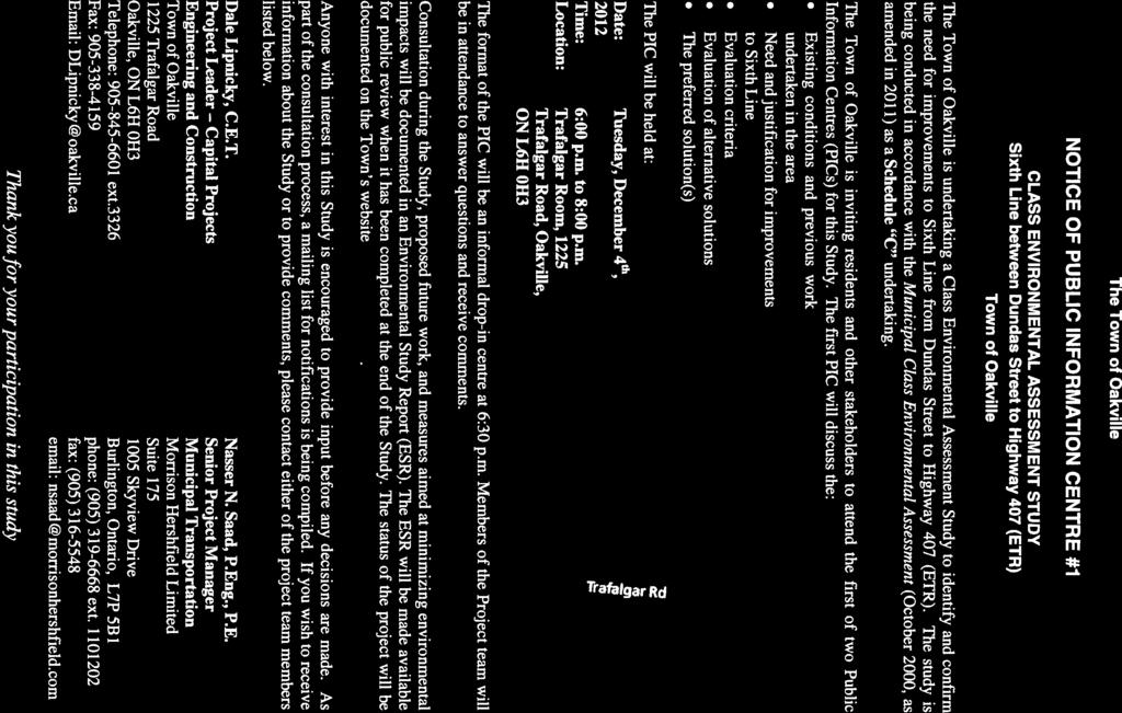

72
73 Public information meeting on December 4 for Class Environmental Assessment Study for Sixth Line... Wednesday, November 28, for immediate release Public information meeting on December 4 for Class Environmental Assessment Study for Sixth Line between Dundas Street to Highway 407 (ETR) Tuesday, December 4, to 8 p.m. Town Hall, Trafalgar Room 1225 Trafalgar Road The Town of Oakville is undertaking a Class Environmental Assessment Study to identify and confirm the need for improvements to Sixth Line from Dundas Street to Highway 407 (ETR). The study is being conducted in accordance with the Municipal Class Environmental Assessment (October 2000, as amended in 2011) as a Schedule C undertaking. You are invited to attend the first of two public meetings, Public Information Centres (PICs) for this study. The first PIC will discuss: Existing conditions and previous work undertaken in the area Need and justification for improvements to Sixth Line Evaluation criteria Evaluation of alternative solutions The preferred solution(s) The format of the PIC will be an informal open house. Members of the project team will be in attendance to answer questions and receive comments. Consultation during the study, proposed future work, and measures aimed at minimizing environmental impacts will be documented in an Environmental Study Report (ESR). The ESR will be made available for public review when it has been completed at the end of the study. The status of the project will be documented on the Sixth Line Environmental Assessment page. You are encouraged to provide input into this study. As part of the consultation process, a mailing list for notifications is being compiled. If you wish to receive information about the study or to provide comments, please contact: Dale Lipnicky, C.E.T. Project Leader Capital Projects Engineering and Construction Town of Oakville 1225 Trafalgar Road Oakville, ON L6H 0H3 Phone: , ext.3326 Fax: DLipnicky@oakville.ca Nasser N. Saad, P.Eng., P.E. Senior Project Manager, Municipal Transportation Morrison Hershfield Limited Suite 175, 1005 Skyview Drive Burlington, Ontario, L7P 5B1 Phone: , ext Fax: nsaad@morrisonhershfield.com Sign up for the town's RSS feeds to get information delivered right to your desktop.
74 SIXTH LINE FROM DUNDAS STREET TO HIGHWAY 407 ETR CLASS ENVIRONMENTAL ASSESSMENT STUDY PUBLIC INFORMATION CENTRE #1 SUMMARY REPORT Appendix B Sample Comment Sheets
75
76 SIXTH LINE FROM DUNDAS STREET TO HIGHWAY 407 ETR CLASS ENVIRONMENTAL ASSESSMENT STUDY PUBLIC INFORMATION CENTRE #1 SUMMARY REPORT Appendix C PIC #1 Presentation Boards
77 Welcome to Public Information Centre #1 Class Environmental Assessment (EA) Study for Sixth Line from Dundas Street to Highway 407 (ETR) December 4, 2012
78 Purpose of the Public Information Centre #1 The purpose of holding this Public Information Centre is to: Introduce the study and provide an opportunity for the public to review the display boards; Provide background information; Presents needs and justification (i.e. problem being addressed); Present alternative planning solutions; Identify the preliminary preferred solution; Present potential benefits / impacts associated with the preliminary preferred alternative planning solution; Obtain public input and comments; and Identify the next steps in the process.
79 Study Purpose The purpose of the EA study is to conduct a Schedule C Class Environmental Assessment to address the transportation needs along the Sixth Line corridor, and allow for a comprehensive assessment of the potential impacts of alternatives on the Social, Natural and Cultural Environment, including: Operational deficiencies; Transit service requirements; Pedestrian and cycling needs; and The need for additional North-South capacity in consideration of current and future planned development along the study corridor.
80 Objectives of the Study The major objectives of this study are to: Complete the Municipal Class EA process with participation from the public and affected parties; Provide satisfactory consideration to a reasonable range of alternatives; Consider the effects on all aspects of the environment and systematic evaluation of alternatives; and Develop preliminary preferred design(s) of recommended alternative.
81 Municipal Class EA Process in Ontario PHASE 1 Identify & Describe the Problem(s) & Opportunities TODAY Problem(s) & Opportunities Statement Public Information Centre #1: December 4, 2012 PHASE 2: Alternative Solutions PREFERRED SOLUTION PHASE 3: Alternative Design Concepts for the Preferred Solution Public Information Centre #2 Tentative Date: Winter 2013 PREFERRED DESIGN PHASE 4: Environmental Study Report (ESR) Tentative Date: May 2013 PHASE 5: Implementation
82 Study Area Sixth Line from Dundas Street to Highway 407 (ETR)


83 Study Background Town s Official Plan-Livable Oakville (2009) Road Hierarchy Study Area Highway 407 ETR Town s Official Plan- Livable Oakville (2009) identifies Sixth Line as Minor Arterial. Dundas Street Note: * Figure adopted from Town s Official Plan-Livable Oakville (2009).
 North Oakville East Secondary Plan (2008) Land Use Study Area Highway 407 ETR North Oakville East Secondary Plan (2008) designated land uses along Sixth Line: between Highway 407 (ETR) and New")

84 Study Background (Cont d.) North Oakville East Secondary Plan (2008) Land Use Study Area Highway 407 ETR North Oakville East Secondary Plan (2008) designated land uses along Sixth Line: between Highway 407 (ETR) and New North Oakville Transportation Corridor as Transitway and Employment Area. Burnhamthorpe Road between New North Oakville Transportation Corridor and Burnhamthorpe Road as Employment Area, Natural Heritage System Area, Stormwater Management Facility, and Transitional Area. between Burnhamthorpe Road and Dundas Street as Sub Urban Area, Stormwater Management Facility, Neighbourhood Park Area, Natural Heritage System Area, Neighbourhood Centre Area, and Dundas Street Urban Core Area. Dundas Street Note: * Figure adopted from North Oakville East Secondary Plan, 2008
 North Oakville East Secondary Plan (2008) Network Improvements Trafalgar Road Sixth Line Bronte Road")
85 Study Background (Cont d.) North Oakville East Secondary Plan (2008) Network Improvements Trafalgar Road Sixth Line Bronte Road Study Area Note: * Figure adopted from North Oakville East Secondary Plan, 2008.
 North Oakville East Secondary Plan (2008) Transit Improvements Study Area Burnhamthorpe Road Highway")

86 Study Background (Cont d.) North Oakville East Secondary Plan (2008) Transit Improvements Study Area Burnhamthorpe Road Highway 407 ETR New North Oakville Transportation Corridor North Oakville East Secondary Plan (2008) identifies: o Sixth Line as Secondary Transit Corridor by 2021; and o Dundas Street as Primary Transit Corridor by Dundas Street Note: * Figure adopted from North Oakville East Secondary Plan, 2008
 Town of Oakville Active Transportation Master Plan (2009) Recommended Cycling and Transit Network Study")
; and o Dundas Street as Multi-use Trail (Off- Road In Boulevard).")
87 Study Background (Cont d.) Town of Oakville Active Transportation Master Plan (2009) Recommended Cycling and Transit Network Study Area Highway 407 ETR Town of Oakville Active Transportation Master Plan (2009) identifies: o Sixth Line as Bike Lane (On-road); and o Dundas Street as Multi-use Trail (Off- Road In Boulevard). Dundas Street Note: * Figure adopted from Town of Oakville Active Transportation Master Plan (2009).


88 Existing Natural Environment Conditions Within the study area there are two linear aquatic ecosystems that cross Sixth Line however these are ephemeral watercourses and were dry during the field investigation. Neither crossing provides fish habitat. Two large ponds were identified at the north end of the study area and both likely support bait fish. o One is within the Highway 407 right-of-way and the riparian habitat was limited to grasses and low herbaceous plants. o The other is on a private property on the east side of Sixth Line, just south of Highway 407 and was surrounded by mowed grass with some trees. The vegetation community within the study area consists of cultural meadow (CUM), deciduous forest (FOD), and agricultural crop land. Pond on private property on the northeast side of Sixth Line at the north end of the study area. Ponds within the Highway 407 right-of-way
; one Funerary (CHL 2); one Religious (CHL 3); two Residentials (CHL 4 and CHL 7); two")
 Munn s Pioneer Cemetery (CHL 2) Munn s Pioneer Church (CHL 3) No.")
89 Existing Cultural and Built Heritage Conditions A total of eight Cultural Heritage Landscapes (CHL) were identified along the study corridor. One is Historical Crossroad Settlement (CHL 1); one Funerary (CHL 2); one Religious (CHL 3); two Residentials (CHL 4 and CHL 7); two Roadscapes (CHL 5 and CHL 6 ); and one Agricultural: Farm Complex (CHL 8). Munn s Corners (CHL 1) Munn s Pioneer Cemetery (CHL 2) Munn s Pioneer Church (CHL 3) No Sixth Line (CHL 4) Burnhamthorpe Road Sixth Line (CHL 5) (CHL 6) No Sixth Line (CHL 7) No Sixth Line (CHL 8)


90 Potential-300m to registered No Potential-previously assessed Natural heritage system Proposed new Burnhamthorpe Road corridor Potential-100m to historic feature Potential-200m to water Due to the proximity to water, topography and soils the Sixth Line study area has the potential for archaeological remains but extensive and intensive disturbances have removed any archaeological potential from within the current right-of-way. No further work within right-of-way area is required. 76 percent of lands adjacent to the Sixth Line right-of-way have potential for archaeological remains. Therefore, any future design changes to the road that require expansion beyond current right-of-way should be subject to a Stage 2 archaeological assessment. A Stage 3 investigation will be required to confirm the presence or absence of unmarked graves at the Munn s Cemetery prior to any land-disturbing activities. Existing Archaeological Conditions
91 Noise Analysis and Stormwater Management Study The Noise Impact and Stormwater Management Studies along Sixth Line between Dundas Street to Highway 407 (ETR) will be conducted as part of this study. The results of the studies will be presented at the second Public Information Centre tentatively scheduled for early 2013.
92 Existing (2012) 1 Future (2031) 1,2 Needs Assessment PM Peak Hour Link Performance Existing and Future (Do Nothing) LEGEND V/C P 1.0 (Over Capacity ) 0.85 < V/C < 1.0 (At Capacity) V/C O 0.85 (Below Capacity) 1) V/C Volume to Capacity ratio threshold used to identify problems (congestion, delay) along the corridor. 2) Signal or potential roundabout at intersections.
93 Needs Assessment (Cont d.) PM Peak Hour Intersection Capacity Analysis Existing (2012) and Future (2031) Existing (2012) C B Level of Service Future (2031) E A A A A B D Level of Service
94 Problem/Opportunity Statement Problem The Town of Oakville is planning for high population and employment growth that will continue over several decades. Transportation analysis confirms that the future traffic volumes will exceed the available north-south capacity within the study area between now and Even with network improvements, the northsouth roadway network in the immediate and surrounding area of Sixth Line will not be able to accommodate the travel demand growth anticipated over the next 20 years. Roadway safety, intersection levels of service, response of emergency vehicles and natural environment will deteriorate without transportation improvements. Opportunity There is an opportunity to improve Sixth Line between Dundas Street and Highway 407 (ETR) in compliance with the Town s Livable Oakville Plan (Official Plan). The improvements will provide opportunity to improve; transit operations; traffic operations; active transportation including pedestrian and bicycle access; road safety; and enhance streetscaping and landscaping.
95 Alternative Planning Solutions 1) Do Nothing. 2) Limit Growth and Development. 3) Transportation Demand Management Initiatives (TDM). Introduce transit service and transit amenities. Provide opportunities for Pedestrians and Cyclists in the study corridor. 4) Transportation System Management (TSM). Programs to reduce congestion and improve traffic flow through traffic signal synchronization and incident management. Programs to implement transit priority measures. 5) Provide Additional Traffic Lanes Along Sixth Line. 6) Intersection Improvements. 7) Upgrade Other Arterial Corridors or Build New Corridor.
96 Natural Environment Cultural Environment Evaluation Criteria Cost Socio-Economic Environment Technical

97 Socio-Economic Environment Resident/Business Access Property Requirements Emergency Response Noise Air Quality Aesthetics/Streetscapes

98 Natural Environment Watercourses Wildlife Vegetation Fish
99 Cultural Environment Archaeological Resources Cultural and Built Heritage
100 Technical Planning Objectives Transit Services Overall Safety Opportunity for Pedestrians and Cyclists Network Capacity and Level of Service Stormwater Management
101 Cost Potential costs for the alternative such as: Property Capital Costs

102 Assessment & Evaluation of Alternative Planning Solutions

103 Assessment & Evaluation of Alternative Planning Solutions (Cont d.)
104 Preliminary Preferred Solution The Preliminary Preferred Solution includes a combination of the following: Alternative 3: Transportation Demand Management Initiatives (TDM); Alternative 4: Transportation System Management (TSM); Alternative 5: Provide additional traffic lanes along Sixth Line; and Alternative 6: Intersection improvements.
105 Next Steps Following this Public Information Centre, the Town of Oakville will: Review all comments received and reassess / confirm the preliminary preferred solution; Respond to all written questions and comments; Generate and develop alternative designs to implement the preliminary preferred solution; Identify the net impacts of the alternative design concepts on the environment, undertake a comparative evaluation and develop a preliminary preferred design; Conduct a second Public Information Centre in early 2013 and present the alternative designs and preliminary preferred design.
106 Your Involvement is Important What issues are critical to you? Please fill out a Comment Sheet Please keep in touch with us: Dale Lipnicky, C.E.T. Nasser N. Saad, P. Eng. Town of Oakville 1225 Trafalgar Road Oakville, ON L6H 0H Ext DLipnicky@oakville.ca Morrison Hershfield Limited 1005 Skyview Drive, Suite 175 Burlington, ON L7P 5B1 (905) , Ext nsaad@morrisonhershfield.com Thank you!
107 SIXTH LINE FROM DUNDAS STREET TO HIGHWAY 407 ETR CLASS ENVIRONMENTAL ASSESSMENT STUDY PUBLIC INFORMATION CENTRE #1 SUMMARY REPORT Appendix D Completed PIC #1 Comments Sheets


108
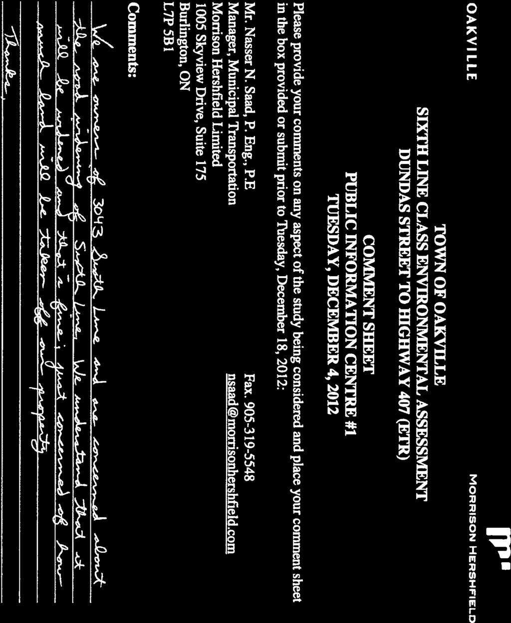
109

110


111


112
113
114
115
116 SIXTH LINE FROM DUNDAS STREET TO HIGHWAY 407 ETR CLASS ENVIRONMENTAL ASSESSMENT STUDY PUBLIC INFORMATION CENTRE #1 SUMMARY REPORT Appendix E Responses to Comments


117

118

119


120


121


122


123

124


125


126
127
128 SIXTH LINE FROM DUNDAS STREET TO HIGHWAY 407 ETR CLASS ENVIRONMENTAL ASSESSMENT STUDY ENVIRONMENTAL STUDY REPORT Appendix A.6 PIC #2 Summary Report
129 SIXTH LINE FROM DUNDAS STREET TO HIGHWAY 407 ETR CLASS ENVIRONMENTAL ASSESSMENT STUDY PUBLIC INFORMATION CENTRE #2 SUMMARY REPORT T OWN OF O AKVILLE SIXTH LINE FROM DUNDAS STREET TO HIGHWAY 407 ETR CLASS ENVIRONMENTAL ASSESSMENT STUDY TOWN OF OAKVILLE PROJECT NO. EA P U B L I C I N F O R M A T I O N C E N T R E # 2 S U M M A R Y R E P O R T M O R R I S O N H E R S H F I E L D L I M I T E D 235 YORKLAND BOULEVARD,SUITE 600 TORONTO,ONTARIO, M2J 1T1 TEL: (416) FAX: (416) JANUARY 16, 2014
130 SIXTH LINE FROM DUNDAS STREET TO HIGHWAY 407 ETR CLASS ENVIRONMENTAL ASSESSMENT STUDY PUBLIC INFORMATION CENTRE #2 SUMMARY REPORT Table of Contents 1 Project Introduction Notifications Public Notification Agencies /Organizations Public Information Centre Sixth Line from Dundas Street to Highway 407 ETR Material Presented Comments Next Steps Contact information...6 List of Tables Table 1 Summary of PIC #2 Comments and Responses...6 List of Figures Figure 1 Study Area Key Plan...3 List of Appendices Appendix A Notice of Public Information Centre #2 Appendix B Appendix C Appendix D Sample Comment Sheets PIC #2 Presentation Boards Completed PIC #2 Comments Sheets 2
 study for improvements to Sixth Line between Dundas Street to Highway 407 ETR as shown in Figure 1.")


131 SIXTH LINE FROM DUNDAS STREET TO HIGHWAY 407 ETR CLASS ENVIRONMENTAL ASSESSMENT STUDY PUBLIC INFORMATION CENTRE #2 SUMMARY REPORT 1 PROJECT INTRODUCTION The Town of Oakville is conducting a Class Environmental Assessment (EA) study for improvements to Sixth Line between Dundas Street to Highway 407 ETR as shown in Figure 1. In order to best address operational deficiencies and the need for additional north-south transportation capacity in the area, a number of alternatives will be examined as part of the study. The study alternatives will include the potential widening of Sixth Line from two lanes to four lanes with the appropriate turning lanes at intersections, cross-sectional elements, intersection improvements, and transit improvements. The study will review and confirm the need for improvements to the corridor and assess alternative solutions, including an evaluation of potential environmental impacts. Upon completion of the study, an Environmental Study Report (Phase 4 of the Study) will be filed for public review. A key component of the study will be consultation with interested stakeholders (public and agencies) at Public Information Centres (PICs). The purpose of the PIC is to obtain public input after reviewing the problem being addressed, background information, the alternative solutions and designs being considered, and identifying a preliminary preferred solution and design. The study is being carried out in accordance with the planning and design process for Schedule C projects as outlined in the Municipal Class Environmental Assessment (October 2000, as amended in 2011), which is approved under the Ontario Environmental Assessment Act. Figure 1 Study Area Key Plan 3
132 SIXTH LINE FROM DUNDAS STREET TO HIGHWAY 407 ETR CLASS ENVIRONMENTAL ASSESSMENT STUDY PUBLIC INFORMATION CENTRE #2 SUMMARY REPORT 2 NOTIFICATIONS 2.1 Public Notification The public was notified of the PIC #2 for Sixth Line from Dundas Street to Highway 407 by: Advertisements that were published in the local newspaper. Notices were sent by mail by prior to the PIC to all stakeholders and agencies according to the project mailing list. A copy of the Notice of Public Information Centre #2 is shown in Appendix A. Online via the Town of Oakville website at Agencies /Organizations Notices were sent to relevant agencies on the initial agency list. Contacts from the Municipal, Provincial and Federal government agencies as well as First Nations were also notified about the Study and PICs. 3 PUBLIC INFORMATION CENTRE A Public Information Centre was arranged for Sixth Line from Dundas Street to Highway 407 ETR (PIC #2). The Public Information Centre was held in the Committee Room #1 at the Oakville Townhall, 1225 Trafalgar Road, Oakville on Wedensday, October 2 nd, 2013, from 6:00pm to 8:00pm. The presentation boards for PIC #2 were organized to provide an opportunity for the public to review the summary of studies completed since the first public information centre, the alternative designs considered, evaluation of alternative designs and identifying a preliminary preferred design and the potential benefits, impacts and mitigation measures associated with the preliminary preferred design. Comment sheets were provided to members of the public who attended to write comments on display boards. A total of 12 members of the public had attended the Public Information Centre for Sixth Line. The Public who attended the PIC were asked to fill the sign-in sheet and to provide comments on comment sheet. A sample comment sheet is presented in Appendix B. 4 SIXTH LINE FROM DUNDAS STREET TO HIGHWAY 407 ETR 4.1 Material Presented The presentation boards for Sixth Line from Dundas Street to Highway 407 ETR are available online at and in Appendix C. The presentation material includes details on: Purpose of the Public Information Centre #2 Study Purpose Objectives of the Study Municipal Class EA Process in Ontario 4
133 SIXTH LINE FROM DUNDAS STREET TO HIGHWAY 407 ETR CLASS ENVIRONMENTAL ASSESSMENT STUDY PUBLIC INFORMATION CENTRE #2 SUMMARY REPORT Study Area Summary of Public Information Centre #1 Problem/Opportunity Statement Summary of Public Information Centre #1 Preliminary Preferred Solution Summary of Feedback and Responses from PIC #1 Summary of Studies Completed for EA Study Alternative Designs for the Widening of Sixth Line from Dundas Street to Highway 407 (ETR) Alternative Design Evaluation Criteria Assessment & Evaluation of Alternative Designs Existing Archaeological Conditions Preliminary Preferred Design - Plan and Profile Preliminary Preferred Design Typical Sections Preliminary Preferred Design Key Features Preliminary Preferred Design Landscaping Concepts Preliminary Preferred Design Construction Phasing Next Steps Members of public were assisted by the Town of Oakville staff, Region of Halton staff and Morrison Hershfield staff to understand the EA process. Feedback was solicited at the PIC from the participants either in-person or by providing a comment sheet. Participants at the PIC had the choice of submitting their comment sheet via a comment box or by mailing the comment sheet to the consultant. Any comments received, except for personal information, would be kept as public record. The comments are summarized below. The completed comment sheets, excluding personal information, are included in Appendix D. 4.2 Comments The PIC provided the public with the opportunity to express their comments and concerns regarding the progress of the project and the presented preliminary preferred solution. In total, 1 comment sheet was collected by drop-in, and by the deadline date of October 11 th, A summary of the received comments and responses is shown in Table 1. 5
134 SIXTH LINE FROM DUNDAS STREET TO HIGHWAY 407 ETR CLASS ENVIRONMENTAL ASSESSMENT STUDY PUBLIC INFORMATION CENTRE #2 SUMMARY REPORT Table 1 Summary of PIC #2 Comments and Responses Item # Comments Responses 1 1. Intersection locations inconsistent with draft plan. 2. Requires direct frontage as per draft plan. The preliminary preferred design was revised for consistency with the draft plan. 3. Matching of grades to proposed development grades. 4.3 Next Steps The Sixth Line EA Study from Dundas Street to Highway 407 ETR needs to complete Phase 4 of Municipal Class EA process. The next steps for the Class Environmental Assessment are: Review all comments and suggestions received from the public and agencies; Respond to written questions and comments, if response is requested; Based on input received from public agencies and other stakeholders, finalize the preliminary design of the preferred alternative; Prepare the Environmental Study Report (ESR); File the ESR and make it available for public review and comments for a minimum 30- day public review period. The ESR is scheduled to file in spring Once the ESR is complete, it will be filed with the Ministry of Environment. A 30 day public review and comment period will follow the filing of the ESR, during which any outstanding issues will be resolved. 5 CONTACT INFORMATION For more information, please contact: Dale Lipnicky, C.E.T. Project Leader Capital Projects Engineering and Construction Town of Oakville 1225 Trafalgar Road Oakville, ON L6H 0H3 Phone: (905) ext.3326 Fax: (905) DLipnicky@oakville.ca John Grebenc, P.Eng. Vice President, Municipal Transportation Morrison Hershfield Limited Suite Yorkland Boulevard Toronto, ON M2J 1T1 Phone: (416) ext, 1810 Fax: (416) JGrebenc@morrisonhershfield.com 6
135 SIXTH LINE FROM DUNDAS STREET TO HIGHWAY 407 ETR CLASS ENVIRONMENTAL ASSESSMENT STUDY PUBLIC INFORMATION CENTRE #2 SUMMARY REPORT Appendix A Notice of Public Information Centre #2

.")
136 Notice of Public Information Centre #2 Sixth Line Environmental Assessment Dundas Street to Highway 407 ETR Wednesday, October 2, p.m Trafalgar Road, Oakville, ON Committee Room 1 You are invited to join us for this open house to review the preferred alternative for improvements to Sixth Line. The meeting will be a drop-in format with members of the project team in attendance to answer questions and receive comments. If you are unable to attend this meeting, please provide any comments you may have on the reverse side of this letter and return to either of the team members by regular mail or by October 11. This Class Environmental Assessment Study will identify and confirm the need for improvements to Sixth Line from Dundas Street to Highway 407 (ETR). The study is being undertaken in accordance with Schedule C of the Municipal Class Environmental Assessment (October 2000, as amended in 2007 and 2011) which is approved under the Ontario Environmental Assessment Act. Morrison Hershfield Limited has been retained to assist with the study. The first Public Information Centre (PIC#1) was held on December 4, 2012 to review the transportation need and justification for the widening of Sixth Line and an assessment of alternative solutions. Contact: Dale Lipnicky, C.E.T. Town of Oakville 1225 Trafalgar Road Oakville, ON L6H 0H3 Telephone: , ext.3326 Fax: dlipnicky@oakville.ca John Grebenc, P. Eng. Morrison Hershfield Limited 235 Yorkland Boulevard, Suite 600 Toronto, ON M2J 1T1 phone: fax: jgrebenc@morrisonhershfield.com
137 Public information meeting on October 2, 2013, for Class Environmental Assessment Study for Sixth... Monday, September 16, for immediate release Public information meeting on October 2, 2013, for Class Environmental Assessment Study for Sixth Line between Dundas Street to Highway 407 (ETR) Wednesday, October 2, 2013, 6 to 8 p.m. Committee Room Trafalgar Road Oakville, ON The Town of Oakville is undertaking a Class Environmental Assessment Study to identify and confirm the need for improvements to Sixth Line from Dundas Street to Highway 407 (ETR). The study is being undertaken in accordance with Schedule C of the Municipal Class Environmental Assessment (October 2000, as amended 2007 and in 2011) which is approved under the Ontario Environmental Assessment Act. Morrison Hershfield Limited has been retained to assist with the study. The first Public Information Centre was held on December 4, 2012, to review the transportation need and justification for the widening of Sixth Line and an assessment of alternative solutions. The second meeting will be a drop-in format with members of the project team in attendance to answer questions and receive comments. If you are unable to attend this meeting, please send your comments to either of the project team members listed below. Dale Lipnicky, C.E.T. Project Leader Capital Projects Engineering and Construction Town of Oakville 1225 Trafalgar Road Oakville, ON L6H 0H3 Telephone: , ext.3326 Fax: dlipnicky@oakville.ca John Grebenc, P. Eng. Vice President Municipal Transportation Morrison Hershfield Limited Suite Yorkland Boulevard Toronto, ON M2J 1T1 phone: fax: jgrebenc@morrisonhershfield.com Sign up for the town's RSS feeds to get information delivered right to your desktop.
138 SIXTH LINE FROM DUNDAS STREET TO HIGHWAY 407 ETR CLASS ENVIRONMENTAL ASSESSMENT STUDY PUBLIC INFORMATION CENTRE #2 SUMMARY REPORT Appendix B Sample Comment Sheets
139 TOWN OF OAKVILLE SIXTH LINE CLASS ENVIRONMENTAL ASSESSMENT DUNDAS STREET TO HIGHWAY 407 (ETR) COMMENT SHEET PUBLIC INFORMATION CENTRE #2 WEDNESDAY, OCTOBER 2, 2013 Please provide your comments on any aspect of the study being considered and place your comment sheet in the box provided or submit prior to Friday, October 11, 2013: Dale Lipnicky, C.E.T. Town of Oakville 1225 Trafalgar Road Oakville, ON L6H 0H3 Telephone: , ext.3326 Fax: John Grebenc, P. Eng. Morrison Hershfield Limited 235 Yorkland Boulevard, Suite 600 Toronto, ON M2J 1T1 phone: , ext.1810 fax: Comments: Thank you for your participation. Information received will be maintained on file for use during the study and will be included in the study documentation. With the exception of personal information, all comments received will become part of the public record. Thank you for your participation in this study
140 SIXTH LINE FROM DUNDAS STREET TO HIGHWAY 407 ETR CLASS ENVIRONMENTAL ASSESSMENT STUDY PUBLIC INFORMATION CENTRE #2 SUMMARY REPORT Appendix C PIC #2 Presentation Boards
141 Welcome to Public Information Centre #2 Class Environmental Assessment (EA) Study for Sixth Line from Dundas Street to Highway 407 (ETR) October 2, 2013
142 Purpose of the Public Information Centre #2 The purpose of holding this Public Information Centre is to: Provide a summary of Public Information Centre #1; Provide a summary of the studies completed since Public Information Centre #1; Present alternative designs considered for improving Sixth Line; Identify the preliminary preferred design; Present potential benefits / impacts associated with the preliminary preferred alternative design; Obtain public input and comments; and Identify the next steps in the process.
143 Study Purpose The purpose of the EA study is to conduct a Schedule C Class Environmental Assessment to address the transportation needs along the Sixth Line corridor, and allow for a comprehensive assessment of the potential impacts of alternatives on the Social, Natural and Cultural Environment, including: Operational deficiencies; Transit service requirements; Pedestrian and cycling needs; and The need for additional North-South capacity in consideration of current and future planned development along the study corridor.
144 Objectives of the Study The major objectives of this study are to: Complete the Municipal Class EA process with participation from the public and affected parties; Provide satisfactory consideration to a reasonable range of alternatives; Consider the effects on all aspects of the environment and systematic evaluation of alternatives; and Develop preliminary preferred design(s) of recommended alternative.
145 Municipal Class EA Process in Ontario PHASE 1 Identify & Describe the Problem(s) & Opportunities Problem(s) & Opportunities Statement Public Information Centre #1: December 4, 2012 PHASE 2: Alternative Solutions PREFERRED SOLUTION TODAY PHASE 3: Alternative Design Concepts for the Preferred Solution Public Information Centre #2 October 2, 2013 PREFERRED DESIGN PHASE 4: Environmental Study Report (ESR) Tentative Date: Winter 2013 PHASE 5: Implementation
146 Study Area Sixth Line from Dundas Street to Highway 407 (ETR)
147 Summary of Public Information Centre #1 Problem/Opportunity Statement Problem The Town of Oakville is planning for high population and employment growth that will continue over several decades. Transportation analysis confirms that the future traffic volumes will exceed the available north-south capacity within the study area between now and Even with network improvements, the northsouth roadway network in the immediate and surrounding area of Sixth Line will not be able to accommodate the travel demand growth anticipated over the next 20 years. Roadway safety, intersection levels of service, response of emergency vehicles and natural environment will deteriorate without transportation improvements. Opportunity There is an opportunity to improve Sixth Line between Dundas Street and Highway 407 (ETR) in compliance with the Town s North Oakville Secondary Plan. The improvements will provide opportunity to improve; transit operations; traffic operations; active transportation including pedestrian and bicycle access; road safety; and enhance streetscaping and landscaping.
148 Summary of Public Information Centre #1 (Cont d.) Preliminary Preferred Solution The Preliminary Preferred Solution includes a combination of the following: Alternative 3: Transportation Demand Management Initiatives (TDM); Alternative 4: Transportation System Management (TSM); Alternative 5: Provide additional traffic lanes along Sixth Line; and Alternative 6: Intersection improvements.
149 Summary of Feedback and Responses from PIC #1 General Comment General Response Active Transportation (i.e. Bike Lanes) Transportation Demand Initiatives including the provision of 1.5m on-street bike lanes have been carried forward as part of the study. Additionally, the existing rural section will be converted to an urban section which will also include sidewalks along both sides of Sixth Line. Property Frontage Property frontage impacts will be taken into consideration while developing and evaluating the alternative design concepts. All efforts will be made to minimize impacts to property. Round-about Installation Intersection improvements have been carried forward as part of Preferred Solution. If the roundabouts could be installed within the existing right-way while addressing all traffic problems for the future conditions, then further evaluation of roundabout option may be considered for traffic calming. The alternative design concepts will be evaluated based on the design criteria established for this EA study. Storm Water Management A Preliminary Storm Water Management (SWM) Study will be conducted as part of this study to review the existing drainage conditions and identify improvements required to accommodate the widening of Sixth Line. The SWM study will be completed in accordance with the applicable standards and will satisfy the requirements of the Town of Oakville and Conservation Halton. Construction Staging Preliminary construction staging will be developed as part of the Class EA. However, final staging plans development and coordination with utility companies will be undertaken during the detail and construction phases of the project. Archaeological Impacts A Stage 1 Archaeological Assessment study is being undertaken as part of the Class EA to evaluate areas of archaeological potentials within the proposed corridor. Mitigation measures alternatives will be developed in accordance with the current applicable standards and guidelines to minimize archaeological impacts.
150 Summary of Studies Completed for EA Study Archaeology There are 66 registered archaeological site within 1 kilometre of the study area. 12 of these sites are within 300 metres of the study area. Due to the proximity to water, topography and soils, the study area has the potential for archaeological remains but extensive and intensive disturbances have removed any archaeological potential from within the current right-of-way. No further work within right-of-way area is required. 76% of the lands adjacent to the Sixth Line right-of-way have potential for archaeological remains. Therefore, any future design changes to the road that require expansion beyond current right-of-way should be subject to a Stage 2 archaeological assessment. A Stage 3 investigation will be required to confirm the presence or absence of unmarked graves at the Munn s Cemetery prior to any land-disturbing activities. Built Heritage and Cultural Landscape A total of eight Cultural Heritage Landscapes (CHL) were identified along the study corridor. One is Historical Crossroad Settlement (CHL 1); one Funerary (CHL 2); one Religious (CHL 3); two Residentials (CHL 4 and CHL 7); two Roadscapes (CHL 5 and CHL 6 ); and one Agricultural: Farm Complex (CHL 8). Three (CHL 2, CHL 3, CHL 7 ) are designated under Part IV of the Ontario Heritage Act; Two (CHL 4, CHL 8) are listed on the Town of Oakville Register of Properties of Cultural Heritage Value or Interest (Not Designated); The remainder were identified through a review of historic mapping and in the course of the field assessment (CHL 1, CHL 5, and CHL 6).
151 Summary of Studies Completed for EA Study (Cont d.) Natural Environment Within the study area, there are two water crossings regulated by Conservation Halton under Ontario Regulation 162/06. These water crossings represent intermittent and ephemeral flow patterns that flow southerly across Sixth Line towards West Morrison Creek. Neither crossings provides fish habitat. The study area contains Oakville-Milton Wetlands and Uplands Provincially Significant Area of Natural and Scientific Interest (ANSI) which also includes the North Oakville-Milton East Provincially Significant Wetland Complex and a significant woodlot located at the south-west of the Sixth Line/Burnhamthorpe Road intersection. This sensitive area will be protected under the planned Natural Heritage System. Further discussions will be held regarding these lands. The project study area provides potential habitat for 6 Species at Risk: Barn Swallow, Canada Warbler, Eastern Meadowlark, Jefferson Salamander, Milksnake and Whippoor-will. Vegetation consists mainly of agricultural crop and meadow communities along with isolated areas of deciduous forest. No rare plant species have been recorded in this area. Geotechnical The existing pavement conditions consist of mm of asphalt on a mm granular base. Full reconstruction of the pavement structure along Sixth Line is recommended.


152 Summary of Studies Completed for EA Study (Cont d.) Stormwater Management & Hydraulic Analysis Drainage along Sixth Line is divided into 6 catchment areas. There are 5 existing culverts crossing Sixth Line which will be replaced or extended to accommodate the proposed road widening. The conveyance of surface runoff will be handled by the installation of trunk sewer along Sixth Line. Quality and quantity control will be handled by stormwater management ponds constructed as part of adjacent development. Ex. 600mm CSP Ex. 2160x900mm Concrete Box Ex. 600mm CSP Culvert Ex. 800mm CSP Ex. 600mm CSP Future SWM Pond (Final locations to be determined)
153 Alternative Designs for the Widening of Sixth Line from Dundas Street to Highway 407 (ETR) The following Alternative Design concepts have been identified to address the preferred solution: 1. Do nothing. 2. Widen to four lanes along the existing centre-line. 3. Widen to four lanes along the existing centre-line and to the east along the natural heritage system. 4. Use of roundabouts at intersections.
154 Alternative Design Evaluation Criteria The following is the proposed Evaluation Criteria to assess the Alternative Design Concepts for the preferred planning solution: Technical Geometry Safety Future development and traffic Compatibility with Active Transportation Master Plan (ATMP) Stormwater Management Utility relocation Transit Service Socio Economical / Cultural Heritage / Archaeological Property Impact Compatibility with Town s North Oakville Secondary Plan / Future Land Use and Development Cultural Heritage Resources Archaeological Resources Natural Environment Potential Impacts to Vegetation Potential Impacts to Wild life Habitats Potential Impacts to Watercourses Potential Impacts to Natural Hazards Access (residential, commercial, and institutional) Noise Impact Air Quality

155 Assessment & Evaluation of Alternative Designs
156 Preliminary Preferred Design (Alternative #3) Proposed Plan & Profile for Sixth Line Displayed on the Table
157 Preliminary Preferred Design (Alternative #3) Proposed Sixth Line Typical Sections
 Proposed Sixth Line")
158 Preliminary Preferred Design (Alternative #3) Proposed Sixth Line Typical Sections
159 Preliminary Preferred Design (Alternative #3) Key Features Sixth Line widened to 4 through lanes from Dundas Street to Highway 407 (ETR); Continuous left turn lane provided throughout; Signalization of intersections to improve traffic operations; 2 to 2.45m sidewalks and 1.66m on-street bike lanes to encourage alternative means of transportation; On-street parking layby s in front of Neighborhood Centre and Park lands; Continuous medians for enhanced streetscaping and landscaping features; and Culvert structure replacements.
160 Preliminary Preferred Design (Alternative #3) Landscaping Concepts Note: Photographs taken from Third Line in the Town of Oakville
161 Preliminary Preferred Design (Alternative #3) Construction Phasing The reconstruction of Sixth Line is currently planned to be undertaken in 3 phases: o Phase 1: Dundas Street to North Park Drive. (Construction Start: 2015) o Phase 2: North Park Drive to Burnhamthorpe Road. (Construction Start: 2020) o Phase 3: Burnhamthorpe Road to Highway 407 (ETR). (Construction Start: 2023)
162 Next Steps Following this Public Information Centre, the Town of Oakville will: Review all comments and suggestions received from the public and agencies. Respond to written questions and comments, if response is requested; Based on input received from public agencies and other stakeholders: o Confirm the Preferred Design alternative o Refine/Finalize the preliminary design of the preferred alternative Prepare the Environmental Study Report (ESR); and File the ESR and make it available for public review and comments for a minimum 30-day public review period.
163 Your Involvement is Important What issues are critical to you? Please fill out a Comment Sheet Please keep in touch with us Dale Lipnicky, C.E.T. John Grebenc, P.Eng. Town of Oakville 1225 Trafalgar Road Oakville, ON L6H 0H Ext DLipnicky@oakville.ca Morrison Hershfield Limited 235 Yorkland Boulevard, Suite 600 Toronto, ON M2J 1T1 (416) , Ext JGrebenc@morrisonhershfield.com Thank you!
164 SIXTH LINE FROM DUNDAS STREET TO HIGHWAY 407 ETR CLASS ENVIRONMENTAL ASSESSMENT STUDY PUBLIC INFORMATION CENTRE #2 SUMMARY REPORT Appendix D Completed PIC #2 Comments Sheets


165
166 SIXTH LINE FROM DUNDAS STREET TO HIGHWAY 407 ETR CLASS ENVIRONMENTAL ASSESSMENT STUDY ENVIRONMENTAL STUDY REPORT Appendix A.7 Correspondences
167 December 4, 2012 Your file Sixth Line between Dundas Street to Highway 407 Our file Mr. Dale Lipnicky Town of Oakville 1225 Trafalgar Road Oakville, ON L6H 0H3 RE: Development Proposal/Plans: Highway improvements - Oakville, ON Mr. Lipnicky, We have evaluated the captioned proposal and NAV CANADA has no objection to the project as submitted. Once additional details of the proposed project are available, insure that prior to any construction a Land Use Submission is filed with this Office. In the event that you should decide not to proceed with this project, please advise us accordingly so that we may formally close the file. If you have any questions, contact the Land Use Department by telephone at or at landuse@navcanada.ca. NAV CANADA's land use evaluation is valid for a period of 12 months. Our assessment is limited to the impact of the proposed physical structure on the air navigation system and installations; it neither constitutes nor replaces any approvals or permits required by Transport Canada, Industry Canada, other Federal Government departments, Provincial or Municipal land use authorities or any other agency from which approval is required. Industry Canada addresses any spectrum management issues that may arise from your proposal and consults with NAV CANADA Engineering as deemed necessary. Yours truly, Aleksandar Trandafilovski for David Legault Manager, Data Collection Aeronautical Information Services cc ONTR - Ontario Region, Transport Canada CPE8 - OAKVILLE (TRAFALGAR MEMORIAL HOSPITAL)(HELI) 1601 Tom Roberts, P.O. Box 9824 Stn T, Ottawa, ON, K1G 6R Tom Roberts, C.P.9824 Succursale T, Ottawa, Ontario, K1G 6R2 Telephone: +1 (866) , Fax: +1 (613) Téléphone: +1 (866) , Télécopieur: +1 (613) Z-LDU-101 Version 1.0
168 Martin-Pierre Blouin From: Nasser Saad Sent: Thursday, December 06, :21 PM To: Sara Fadaee; Martin-Pierre Blouin Subject: FW: CLASS EA Sixth Line between Dundas St to Highway 407, Oakville NEATS Attachments: RDIMS-# v2-NWP_APP_GUIDE_EN.PDF; Application Form June 2012.pdf For your File. No action Required yet. We will wait till we get all comments. Thanks Nasser N. Saad, P.Eng., P.E Designated Consulting Engineer Senior Transportation Manager Suite 175, 1005 Skyview Drive Burlington, ON L7P 5B1 Dir: x Fax: morrisonhershfield.com From: EnviroOnt Sent: Thursday, December 06, :14 PM To: Cc: Nasser Saad Subject: CLASS EA Sixth Line between Dundas St to Highway 407, Oakville NEATS Thank you for the information regarding the above referenced project. We have reviewed the information, and note the following: Transport Canada is responsible for the administration of the Navigable Waters Protection Act (NWPA), which prohibits the construction or placement of any works in navigable waters without first obtaining approval. If any of the related project undertakings cross or affect a potentially navigable waterway, the proponent should prepare and submit an application in accordance with the requirements as outlined in the attached Application Guide and Form. Any questions about the NWPA application process should be directed to the Navigable Waters Protection Program at (519) or NWPontario-PENontario@tc.gc.ca. Please review the Minor Works and Waters (Navigable Waters Protection Act) Order, established to outline the specific standards and criteria under which Transport Canada considers a work as a minor and does not require an application under the NWPA. It is the responsibility of the applicant, prior to submitting an application to the Navigable Waters Protection Program for review, to assess whether their work meets the criteria, as described, and, therefore, falls within one of the excluded classes. An application will only be required if it is determined that the work cannot meet the criteria established for that particular class of excluded work. Transport Canada is also responsible for inspecting and auditing federally regulated railway companies that are subject to the Railway Safety Act. Transport Canada also regulates some provincial shortlines from the Province of Ontario that are part of an Agreement between the Federal Government and the Province of 1
169 Ontario. The Railway Safety Act, with related regulations and rules, provides the legislative and regulatory framework for safe railway operations in Canada. The rail safety program develops, implements and promotes safety policy, regulations, standards and research, and in the case of railway grade crossings, subsidizes safety improvements. A list of all the Rail Safety legislations (the Act, Regulations, Rules, Guidelines, Policies and Standards) that applies to the federally regulated railways, can be found here: The Act also addresses the construction and alteration of railway works, the operation and maintenance of railway equipment and certain non-railway operations that may affect the safety of federally regulated railways. If a proposed railway work is of a prescribed kind, pursuant to the Notice of Railway Works Regulations, the proponent shall not undertake the work unless it has first given notice of the work in accordance with the regulation. More information related to railway works is available at the following internet sites: Railway Safety Act: Notice of Railway Works Regulations: Standards Respecting Pipeline Crossings Under Railways: Guideline on Requesting Approval to Undertake Certain Railway Works: General inquiries about the Rail Safety Program can be directed to RailSafety@tc.gc.ca or by calling Please address future correspondence to the Environment and Engineering group to the undersigned address: Thank you, Environmental Coordinator, Transport Canada - Ontario Region (PHE) 4900 Yonge Street, North York, ON M2N 6A5 EnviroOnt@tc.gc.ca 2


170
171


172

173
174
175

176
177
178
179 July 15, 2013 Conservation Halton 2596 Britannia Road West Burlington, ON L7P 0G3 Attention: Jane DeVito Re: Municipal Class EA Sixth Line Improvements, Dundas Street to Highway 407 Town of Oakville CH File: MPR 614 Morrison Hershfield has prepared a status update on Conservation Halton s January 22, 2013 preliminary comments. Ontario Regulation 162/06 1. The study area contains tributaries of West Morrison Creek. Conservation Halton regulates the erosion and flooding hazards and the 7.5 metre allowance associated with these tributaries. The study area also contains several units of the North Oakville-Milton East Provincially Significant Wetland Complex and the 120 metre allowance associated with these features. Ontario Regulation 162/06 requires that a Permit be obtained from Conservation Halton prior to development, interference with wetlands or alterations to shorelines and watercourses. A copy of Ontario Regulation 162/06 and the associated Policy document, Policies and Guidelines for the Administration of Ontario Regulation 162/06 and Land Use Planning Policy Document can be found at Please ensure that the EA contains sufficient information to allow Conservation Halton staff to determine whether a Permit could be issued at detailed design. The EA should identify areas where Permits pursuant to Ontario Regulation 162/06 will be required and include such Permits as future commitments in the ESR. Some details related to future Permits may not be deferred to detailed design. Please review the requirements of Policy 3.51 (Public Infrastructure Utilities, Trails and Transportation) of Conservation Halton s Policies and Guidelines for the Administration of Ontario Regulation 162/06 and Land Use Planning Policy Document. Morrison Hershfield will identify areas where permits pursuant to Ontario Regulation 162/06 will be required and include such permits as future commitments in the ESR. 2. Please plot all areas regulated by Conservation Halton on drawings. At a minimum, the Approximate Regulation Limit (ARL) for West Morrison Creek should be based on a 7.5 metre allowance from the greater of the Regional Storm flood plain and meander belt allowance provided on Drawing 2, Lower West Morrison Creek Limit of Existing Stream Corridor, provided within the Lower West Morrison Creek and the Timsin/Arrassa Lands EIR/FSS. The ARL should be adjusted in the vicinity of the exiting West Morrison Creek (Reach MOC-W1) crossing of Sixth Line where the flood plain has been modified to reflect the proposed grading in this location Morrison Hershfield Suite 600, 235 Yorkland Blvd., Toronto, ON M2J 1T1, Canada Tel Fax morrisonhershfield.com
180 - 2 - (see Conceptual Grading Plan for Spill Containment within EOR/FSS for this purpose). Ideally the limits of the regulated area would be further updated based on detailed topographical survey data acquired through the EA process. Morrison Hershfield will plot all regulated areas on drawings and make all necessary adjustments for Conservation Halton review. 3. A Data Request Form is required for all digital information requests. This form and additional information on data holdings can be found in the GIS & Mapping section of Conservation Halton s website: Staff notes that the following modeling is available for the study area: a. West Morrison Creek Hydraulic Model & Mapping prepared by Stantec Consulting for Timsin-Arrassa Subdivision Development. b. For areas beyond those covered by the above model/mapping, West Morrison Creek Hydraulic Model & Mapping prepared by TSH for North Oakville Creeks Subwatershed Study. Morrison Hershfield did not require any information from Conservation Halton as received directly from developers. 4. It is recommended that potential impacts to natural hazards (flooding and/or erosion hazards) should be one of the evaluation criteria. At a minimum, a proposed alternative must have no negative impacts on flooding and erosion hazards in order for Conservation Halton to issue a future approval under Ontario Regulation 162/06. Opportunities to improve any deficiencies with respect to flooding and erosion should be investigated. Morrison Hershfield will include potential impacts to natural hazards as part of the evaluation criteria in the ESR. 5. The EA should assess all flood plain impacts associated with each alternative including consideration of any change in storage, velocity and up and down stream water levels for a variety of flow conditions. This may be deferred in the Environmental Study Report to a future EIR/FSS depending on the level of approval desired through this study. The Town of Oakville has deferred to a future EIR/FSS study. 6. A hydrologic and/or hydraulic analysis may be required in the Environmental Study Report depending on the level of approval desired through the study. The Town of Oakville has deferred to the detailed design stage. 7. Please consider MTO s flooding criteria, guidelines and/or the municipal engineering standards for flooding along/over roads. At a minimum, safe access & egress as defined in the MNR s 2002 Technical Guide: River & Stream Systems Flooding Hazard Limit, should be provided. While not required, it is recommended that there be no overtopping of the roadway under Regional Storm conditions. Noted
181 If a roadway is considered by the Province or local municipality to be an Emergency Route, then there should be no overtopping of the road with flood waters. Noted 9. A fluvial geomorphological assessment may be required in the Environmental Study Report depending on the level of approval desired through the study. The Town of Oakville has deferred to the detailed design stage. 10. Please contact staff to arrange a site visit with the Ministry of Natural Resources to stake the Provincially Significant Wetlands associated with Core #7. An OLS must be present during this site visit. Morison Hershfield has contacted Conservation Halton to schedule the staking of the Core#7 wetlands. The Town of Oakville will arrange for an OLS to be present. 11. A hydrologic evaluation should be incorporated into the EA to determine if there is an impact to the hydrological functions of the wetland as a result of the proposed works. The Town of Oakville has deferred to the detailed design stage. 12. A topographic survey is required to identify the lands impacted by the flooding hazard associated with West Morrison Creek. The Town of Oakville has deferred to the detailed design stage if not undertaken by adjacent developments. Natural Heritage While Conservation Halton recognizes that Environmental Assessments are not subject to and/or limited to the policies outlined in the Provincial Policy Statement (PPS), we do believe that the PPS provides Provincial direction on how natural resources should be managed in Ontario. Furthermore, it is useful for identifying some of the key natural heritage features, water resources, and natural hazards that should be considered when evaluating any sort of development proposal. As such, some PPS related items have been outlined below, as we believe these items should be acknowledged and addressed as part of the EA study. 13. When undertaking any fieldwork and /or when making recommendations related to the natural heritage and/or natural hazards, staff recommend that reference be made to the following guidelines prepared by the Ministry of Natural Resources: Natural Heritage Reference Manual for Natural Heritage Policies of the Provincial Policy Statement, 2005, 2nd Edition, 2010; Significant Wildlife Habitat Technical Guideline; and, Natural Hazards Technical Guide and Understanding Natural Hazards. In addition, reference should be made to the North Oakville Creeks Subwatershed Study. Noted
182 The study area may contain or pass between natural features. As per Policy of the Provincial Policy Statement, the diversity and connectivity of natural features in an area, and the long-term ecological function and biodiversity of natural heritage systems, should be maintained, restored or, where possible, improved, recognizing linkages between and among natural heritage features and areas, surface water features and groundwater features. The use of ecopassages or other measures to facilitate wildlife movement should be evaluated at both locations where linkages of the North Oakville Natural Heritage System cross Sixth Line. Barrier fencing should also be considered along the east edge of Core #7 to reduce movements of wildlife onto the road. NOCSS identifies a 100 metre wide linkage along Morrison Creek in the study area. The ultimate location of this linkage and creek block should be discussed with the adjacent landowners. Eco-passages were not required as part of the Sixth Line Environmental Impact Study. Potential locations for eco-passages will be documented in the ESR for further consideration. 15. As noted above, the study area contains several units of the North Oakville-Milton East Provincially Significant Wetland Complex. As per Policy of the Provincial Policy Statement, development and site alteration shall not be permitted in significant wetlands. Specifically, this may require that the alignment of the road be shifted east along Core #7. The proposed alignment of Sixth Line has been shifted east along Core # The study area may contain the habitat of Endangered or Threatened species. As per Policy of the Provincial Policy Statement, development and site alteration shall not be permitted in the habitat of Endangered/Threatened Species. The provincial Endangered Species Act and/or federal Species at Risk Act may also apply. Please contact Melinda Thompson (Melinda.thompson@ontario.ca, ) of Aurora District MNR for further information on Endangered Species Act requirements. Morrison Hershfield will document the Endangered Species Act requirements in the ESR. 17. The study area contains the Oakville-Milton Wetlands and Uplands Provincially Significant Area of Natural and Scientific Interest (ANSI), Significant Woodlands and may contain significant wildlife habitat. As per Policy of the Provincial Policy Statement, development and site alteration shall not be permitted in any of the above noted features unless it has been demonstrated that there will be no negative impacts on the natural features or their ecological functions. Specifically, this may require that the alignment of the road be shifted east along Core #7. Please contact the MNR for further information on ANSI s and the Region of Halton for further information of Significant Woodlands. The Ministry of Natural Resource s Significant Wildlife Habitat Technical Guidelines and the North Oakville Creeks Subwatershed Study can be consulted for significant habitat issues. The proposed alignment of Sixth Line has been shifted east along Core #7. The staking of Core #7 is being arranged to identify limits of the Provincially Significant Wetland Complex. ANSI s and significant woodlands have been identified in the Environmental Impact Study.
183 Development and site alteration shall not be permitted on adjacent lands to the natural heritage features and areas identified in Policies 2.1.3, 2.1.4, and of the Provincial Policy Statement unless the ecological function of the adjacent lands has been evaluated and it has been demonstrated that there will be no negative impacts on the natural features or on their ecological functions. Specifically, this may require that the alignment of the road be shifted east along Core #7. The Ministry of Natural Resources Natural Heritage Reference Manual for Natural Heritage Policies of the Provincial Policy Statement 2005, Second Edition (2010) considers adjacent lands to be within 120 metres. The proposed alignment of Sixth Line has been shifted east along Core #7. Potential ramifications will be documented in the ESR and summarized in the next PIC under reports completed. 19. Please use Ecological Land Classification to map natural and semi-natural features to vegetation type and identify protection/mitigation measures. ELC data sheets are required with the ESR submission (please include digital species spreadsheets). ELC data sheets will be included in the ESR as part of the Environmental Impact Study. 20. Please refer to Conservation Halton s Environmental Impact Study Guidelines for information on general study requirements, impact assessment and appropriate timing and protocols for surveys. These guidelines can be found at Noted 21. Conservation Halton s Landscape Guidelines should be consulted at detailed design. These guidelines can be found at Noted Fish Habitat Impacts 22. Staff recommends that any watercourse crossing of Sixth Line have an open bottom design that spans three times the bankfull channel width of the watercourse, where feasible. Where existing culverts are closed bottom, we generally recommend that they are replaced with an open bottom structure that adequately conveys sediment and are large enough in size to accommodate fish passage up to and during a 25 year storm event. Morrison Hershfield will document in the ESR to be considered as part of the detailed design works. 23. Please discuss quality/quantity/erosion controls within the Stormwater Management Section of the Environmental Study Report. Please examine the potential to combine SWM with adjacent development. Low Impact Development measures should be utilized to the maximum extent possible. Morrison Hershfield will document in the ESR.
184 As per the North Oakville Creeks Subwatershed Study, the following SWM requirements are identified: a. Quality requirements are Enhanced water quality controls. Please discuss the mitigation of thermal impacts. b. The quantity requirements are that all new paved areas meet the unit area target flow rates provided in the Flow Rates/Hydrology Mediation Item. c. The erosion control requirements are to be determined on a subcatchment basis based on an erosion threshold methodology. In the event that the subject lands cannot be serviced in conjunction with the adjacent development lands, as an alternative the 25mm rainfall event should be detained and released over a 24 to 48 hour period. Morrison Hershfield will document in the ESR. 25. Please identify existing vs proposed drainage areas. Every effort should be taken to maintain existing drainage divides. Any proposed diversions must be clearly identified and the potential impacts fully assessed as part of the project s evaluation. Existing and proposed drainage areas will be completed as part of adjacent draft plan applications or the detailed design for Sixth Line Other 26. Is infrastructure proposed within existing easements/r-o-w or are there additional property requirements? Please assess the impacts of utility relocation (i.e. telephone poles, union gas, etc.) on natural heritage features, natural hazard areas and fish habitat. This should not be left to detailed design as the relocation can have a significant impact on natural heritage features. Morrison Hershfield will identify utility relocations and their impact on heritage features as part of the ESR. 27. Please identify groundwater recharge/discharge areas and hydrological impacts. Please identify recommended mitigation measures for groundwater impacts and if appropriate, any opportunities to improve infiltration. Works to be undertaken as part of adjacent draft plan applications 28. The Lower West Morrison Creek and the Timsin/Arrassa Lands EIR/FSS recommendations and findings should be incorporated into the Environmental Study Report. This report discusses specifically drainage from and stormwater management for portions of Sixth Line that are located within the EA study area. Morrison Hershfield will include as part of the ESR. 29. Please refer to the additional details discussed at the Monday, October 1, 2012 meeting. Already resolved, otherwise to be noted in ESR.
185

186
187
188 Martin-Pierre Blouin From: Sent: To: Cc: Subject: Follow Up Flag: Flag Status: John Grebenc Wednesday, December 18, :45 PM Martin-Pierre Blouin; Dale Lipnicky Paul Allen FW: Sixth Line Environmental Assessment Dundas Street to Highway 407 ETR Oakville Follow up Flagged Dale, fyi below. Martin, can you take them of the list, when you have time when I m in can you log on to their site, so we can see what they have and we can use this as a future tool. John J. Grebenc, P. Eng. Vice President, Municipal Transportation jgrebenc@morrisonhershfield.com Suite 600, 235 Yorkland Blvd. Toronto, ON M2J 1T1 Dir: x Fax: morrisonhershfield.com From: CAU-UCA [mailto:cau-uca@aadnc-aandc.gc.ca] Sent: Wednesday, December 18, :10 PM Subject: Sixth Line Environmental Assessment Dundas Street to Highway 407 ETR Oakville Hello Project Leadership, I am writing on behalf of the Consultation Information Service (CIS) of Aboriginal Affairs and Northern Development Canada (AANDC). As a rule, AANDC officials do not participate in environmental assessments that pertain to projects off-reserve, nor does the department track how other parties carry out their EAs. Therefore, in future please omit AANDC officials from your public information notification for projects that do not intersect with reserve land. This information has been relayed to the Ministry of Environment of Ontario; their contact list will be updated. If you are not requesting Aboriginal consultation information please remove us from your notification mailing list. If you are contacting AANDC to request Aboriginal consultation information (community information, claims and assertions), this is to let you know that AANDC has now launched the Aboriginal and Treaty Rights Information System (ATRIS). This Web-based system uses a mapping interface to provide information to federal officials and other interested parties on the location and nature of established and potential Aboriginal and Treaty rights. With ATRIS bringing together information regarding Aboriginal groups such as their exact location, their established rights (through treaties 1
189 and other agreements) and their asserted rights through claim processes and also enabling users to relate many types of AANDC corporate data within a geographical and consultation context, ATRIS has become the main platform for Canada to disseminate its real or constructive knowledge of Aboriginal and treaty rights in Canada. Due to the recent public availability of ATRIS, the role of CIS is currently in transition. That is, the focus of the CIS is shifting away from its former practice of providing written responses to written requests for information on established or potential Aboriginal and treaty rights to managing and supplementing the content in ATRIS. Previously, we prepared these responses by drawing on ATRIS. Now that ATRIS is widely available, we are sending those making requests for Aboriginal consultation information to ATRIS so they can locate the information directly. By focusing our attention on building up and improving the content of ATRIS, the CIS will be able to provide consistent and comprehensive information more efficiently. To begin research in ATRIS, requesters from outside of the federal government can go directly to At the ATRIS Help button, there are answers to frequently asked questions, a glossary, and instructions on how to navigate the system. Please keep in mind that some of the information provided by ATRIS will be contextual. Depending on your project, information that comes up in a search may or may not pertain to Aboriginal or treaty rights in your particular project area. In most cases, therefore, the Aboriginal communities identified by ATRIS are best placed to explain their traditional use of land, their practices, or their claims that may fall under section 35 of the Constitution Act, If, after conducting your research, you have specific questions on how to use ATRIS, we will endeavor to assist you if you contact the CIS through the address: UCA-CAU@aadnc-aandc.gc.ca. In such instances, to facilitate a more timely response, please use the following in the subject line of your Consultation information [a short name for your Project] [Location of your project]. Thank you for your understanding and cooperation, Consultation and Accommodation Unit, AANDC, HQ 2
190
191
192 David Faye & Associates Inc. 338 Lakeshore Road East P.O. Box Oakville, ON L6J 7N5 April 11, 2014 Attention: Re: Mr. David Faye Sixth Line Environmental Assessment Dundas Street to Highway 407 ETR Thank you for your letter of December 2, 2013 regarding our Environmental Assessment for Sixth Line from Dundas Street to Highway 407 ETR. In response to your concerns, please find below our comments. 1. The character of Sixth Line will not vary significantly from the intended parameters identified within the North Oakville East Secondary Plan. Neighbourhood Centre s will continue to be planned for both the east and west sides of Sixth Line along with a Neighbourhood Activity Node south of Burnhamthorpe Road. Parking lay-by s will be permitted where deemed appropriate through the development process and to encourage alternative modes of transportation, on-road cycling lanes and oversized sidewalks will be provided on both sides of Sixth Line. The recommended cross-sections for Sixth Line were developed not only to accommodate future 2031 traffic volumes, but boulevard and lane widths were also reduced in an effort to minimize the land impacts on the adjacent landowners. 2. Following discussions with Conservation Halton staff, and in an effort to minimize the impact the new roadway would have on the Natural Heritage System lands south of Burnhamthorpe Road, it was determined that Sixth Line would be shifted easterly across the frontage of the NHS lands between Street C and Burnhamthorpe Road. 3. Upon request, the Town of Oakville reviewed the proposed alignment of Sixth Line in the area of the Star Oak lands which are located north and south of the existing Burnhamthorpe Road intersection with Sixth Line. As a result of this further review, a modification to the alignment has taken place north of Burnhamthorpe Road which will result in the approximate 12 metre Town of Oakville 1225 Trafalgar Road, Oakville, Ontario L6H 0H
193 widening on the east side of Sixth Line being reduce to approximately 6.0 metres across the Star Oak lands. 4. As you have indicated, Phase 1 is currently proceeding in 2015 as planned. However, recognizing that development is advancing quickly along the Sixth Line corridor, staff will review the need to advance future phases through our annual review of our 10 Year Capital Budget Forecast. 5. The proposed roundabout at the Sixth Line/NNOTC intersection is an initiative being brought forward by the Region of Halton. Concerns regarding its proposed design and resulting land requirements are to be addressed by Regional staff. Thank You, Dale Lipnicky, C.E.T. Project Leader Capital Projects
194
195
196 Matson, McConnell Ltd. 2430A Bloor Street West Toronto, ON M6S 1P9 April 11, 2014 Attention: Re: Mr. Christopher Matson Sixth Line Environmental Assessment Dundas Street to Highway 407 ETR Thank you for your letter of December 9, 2013 regarding the current undertaking of the Environmental Assessment for Sixth Line from Dundas Street north to Highway 407 ETR. Please find your comments and our response to your questions and/or concerns below (your comments in italics). 1. On behalf of our client, we have the following comments for your consideration: Sixth Line is classified as a Minor Arterial/Transit Corridor with Secondary Transit Corridor Service proposed according to Figure NOE 4 of the North Oakville East Secondary Plan ( NOESP ). Table 2 of Section of the NOESP provides that the ROW width for a Minor Arterial/Transit Corridor shall be kept to a minimum, but typically will not exceed a maximum of 26 metre, except at approaches to major intersections where medians and or turn lanes are requires. The proposed increase in ROW width to 31 metres from Dundas Street to Highway 407 does not comply with Council policy contained in the NOESP and would create a major roadway which would be out of context with its intended function and character. The character of Sixth Line will not vary significantly from the original guidelines developed within the North Oakville East Secondary Plan. Sixth Line will continue to have Neighbourhood Centre Area s along with a Neighbourhood Activity Node south of Burnhamthorpe Road. Parking lay-by s will be permitted where deemed appropriate. Sidewalks will be provided on both sides of Sixth Line along with multi-use pathways where possible. Every effort has been made to minimize the right-of-way width to reduce the impact on adjacent landowners while at the same time, accommodate future 2031 traffic volumes in the area. Town of Oakville 1225 Trafalgar Road, Oakville, Ontario L6H 0H
197 2. During the in-depth negotiations and processing of the Secondary Plan and Master Plan, the intention was for Sixth Line to be an active street with direct access to residential units with the ability to contain lay-by lanes similar to the west side of Proudfoot Train opposite the park, south of Dundas Street. It appears from the proposed sections for Sixth Line that the preferred option has no lay-by lanes, or any potential for add lay-by s. This is not consistent with the Secondary Plan negotiations and settlement between the Town and North Oakville landowners. Please be advised that the ESR for Sixth Line will not preclude the potential for lay-by parking on Sixth Line, south of Burnhamthorpe Road. The appropriateness of lay-by lanes and the associated parking will be determined through the development process by our Planning and Development Engineering Departments. The final ESR will not illustrate lay-by parking on the plan view, however, typical sections will show its potential and the report itself will indicated that lay-by parking will be considered. 3. The location of the NHS Linkage on the west side of Sixth Line was specifically designed to allow a cud-de-sac road with lotting on both sides, together with a single tier of lots fronting onto Sixth Line with a lay-by lane (see attached Draft Plan showing the future lotting pattern). This configuration would not be possible with a widened Sixth Line road Right-of-Way. Sixth Line has been designated a Minor Collector north of Dundas Street which requires it to accommodate pedestrians, cyclists, vehicular traffic and transit within this corridor. As lands are developed along the Sixth Line corridor, area developers are also increasing the number of mid-block intersections to provide access to their lands. As the number of intersections increase and the spacing between them decreases, sufficient taper lengths are not available to reduce the 31 metre right-of-way to the originally intended 26 metres. Yours Truly, Dale Lipnicky, C.E.T. Project Leader Capital Projects
198
199

200
201
202
203
204
205

206

207
208 Urbantech West 2030 Bristol Circle Suite 201 Oakville, ON L6H 0H2 April 11, 2014 Attention: Re: Mr. Paul Brown Sixth Line Environmental Assessment Dundas Street to Highway 407 ETR Thank you for your letter of January 27, 2014 regarding our Environmental Assessment for Sixth Line from Dundas Street to Highway 407 ETR. Please be advised that your comment will form part of the ESR (Environmental Study Report) for Sixth Line, Dundas Street to Highway 407 (ETR). Thank You, Dale Lipnicky, C.E.T. Project Leader Capital Projects Town of Oakville 1225 Trafalgar Road, Oakville, Ontario L6H 0H
209
210
211
212 North Oakville Community Builders Inc Dufferin Street Suite 104 Vaughan, ON L4K 0C5 April 11, 2014 Attention: Re: Templar Tsang-Trinaistich Sixth Line Environmental Assessment Dundas Street to Highway 407 ETR Thank you for your letter of March 27, 2014 regarding our Environmental Assessment for Sixth Line from Dundas Street to Highway 407 ETR. In response to your concerns, please find below our comments corresponding to your original letter. 1. The character of Sixth Line will not vary significantly from the intended parameters identified within the North Oakville East Secondary Plan. Neighbourhood Centre s will continue to be planned for both the east and west sides of Sixth Line along with a Neighbourhood Activity Node south of Burnhamthorpe Road. Parking lay-by s will be permitted where deemed appropriate through the development process and to encourage alternative modes of transportation, on-road cycling lanes and oversized sidewalks will be provided on both sides of Sixth Line. The recommended cross-sections for Sixth Line were developed not only to accommodate future 2031 traffic volumes, but boulevard and lane widths were also reduced in an effort to minimize the land impacts on the adjacent landowners. 2. Following discussions with Conservation Halton staff, and in an effort to minimize the impact the new roadway would have on the Natural Heritage System lands south of Burnhamthorpe Road, it was determined that Sixth Line would be shifted easterly across the frontage of the NHS lands between Street C and Burnhamthorpe Road. 3. Upon request, the Town of Oakville reviewed the proposed alignment of Sixth Line in the area of the Star Oak lands which are located north and south of the existing Burnhamthorpe Road intersection with Sixth Line. As a result of this further review, a modification to the alignment has taken place north of Burnhamthorpe Road which will result in the approximate 12 metre widening on the east side of Sixth Line being reduce to approximately 6.0 metres across the Star Oak lands. Town of Oakville 1225 Trafalgar Road, Oakville, Ontario L6H 0H
213 4. Sixth Line has been designated a Minor Collector north of Dundas Street which requires it to accommodate pedestrians, cyclists, vehicular traffic and transit within this corridor. As lands are developed along the Sixth Line corridor, area developers are also increasing the number of mid- block intersections to provide access to their lands. As the number of intersections increase and the spacing between them decreases, taper lengths are not available to reduce the 31 metre right-of-way to the originally intended 26 metres. 5. As you have indicated, Phase 1 is currently proceeding in 2015 as planned. However, recognizing that development is advancing quickly along the Sixth Line corridor, staff will review the need to advance future phases through our annual review of our 10 Year Capital Budget Forecast. 6. The proposed roundabout at the Sixth Line/NNOTC intersection is an initiative being brought forward by the Region of Halton. Concerns regarding its proposed design and resulting land requirements are to be addressed by Regional staff. Thank You, Dale Lipnicky, C.E.T. Project Leader Capital Projects
214 SIXTH LINE FROM DUNDAS STREET TO HIGHWAY 407 ETR CLASS ENVIRONMENTAL ASSESSMENT STUDY ENVIRONMENTAL STUDY REPORT Appendix A.8 Agency Meeting Minutes
215 MINUTES Storm Water Management Meeting Project: RFP No.: Class Environmental EA (Schedule C ) Sixth Line from Dundas Street to Hwy 407 (ETR) PROP MH Project No.: Place: Town of Oakville, Oakville Room Date: Monday October 01, 2012 Time: Present: 1:00 p.m. 3:00 p.m. Dale Lipnicky Paul Allen Kristina Parker Rita Juliao Leah Smith Janette Brenner Peter C Wong Sara Fadaee Karen Edgington Rebecca Swabey Town of Oakville (Town) Town of Oakville Town of Oakville Town of Oakville Conservation Halton (CH) Conservation Halton Morrison Hershfield Limited (MH) Morrison Hershfield Limited Morrison Hershfield Limited Morrison Hershfield Limited ITEM MINUTES ACTION BY 1. Purpose The intent of this meeting was to have MH provide basic information on the beginnings of their storm water review and to meet with the Halton conservation and find out what SWM requirements and issues that we are going to expect for this study. 2. Discussions MH presented two preliminary drawings showing the location of watercourses, and future pond locations (base on the New North Oakville Transportation Corridor EA) for the discussion purpose. MH presented information about the four existing culverts in the study area and their respective drainage areas and flow. CH discussed the need for a more detailed survey of Morrison Creek. It was discussed that the Town s Survey Staff will be undertaking a detailed survey of Sixth Line, this information will be passed on to MH upon completion Spill information was discussed, MH can obtain information regarding the south lands by reviewing the Timsin EIR Town MH
216 2 Town mentioned that Timsin will not be taking storm water from the south end of Sixth Line as detailed in their report. in addition they inquired MH to identify the locations where the drainage can go in the future. Town indicated to remain the lead on future pond locations. They advised MH that all future pond locations identified on the map are not going to be built and MH will need to update map based on more recent information. MH confirmed that the final report is due May or June and a draft will be submitted approximately one month beforehand. MH is to submit 3 hard copies of all reports. MH indicated that the first PIC will not focus on SWM and that the pertenant drainage study will be consolidated in Phase 3 of the study before confirmation of the preferred alternative. Town advised that Stantec is undertaking the SWM study from Ninth Line to Trafalgar Road and Corresponding information may be used for the Sixth Line Study CH / Town expressed that their interest is to keep the East and West Morrison Creek in the existing subwatersheds. MH indicated its readiness to get stormwater into the ponds and design the low points now. Town inquired MH to layer future cross streets on map to get a sense of what can be done with grading. Town staff advised that the actual detailed design and widening of Sixth Line would be undertaken in conjunction with adjacent development and therefore additional details/coordination of the roadway as it relates to adjacent development could be refined through the North Oakville EIR/FSS process. It was discussed that the ESR could provide general guidance and identify those areas/requirements that would be refined through the EIR/FSS process. It was discussed that the ESR could list a hierarchy of SWM options (i.e. use SWM ponds directly if possible, if not pay for over-control within SWM ponds, if not use on-site/row storage). Town indicated that the EA should be framed in terms of which issues are still out there and what can be resolved now. Town also mentioned that the EA should establish the process for how things should be laid out. Town inquired MH to write a report and in the future an addendum can be added to the report, if necessary. CH/ Town was concerned about the Morrison Creek realignment since the details of the creek realignment have not been finalized yet. also It was mentioned that whether the creek is lowered or raised would be a significant factor to the SWM for the area. Town inquired MH to start with the preliminary work that Timsin sent out. CH recommended that a Technical Advisory Group meeting to be arranged prior to going to the first PIC to allow for further agency MH MH MH MH Town/ MH MH MH MH MH Town/ MH
217 3 input. The Town is to organize this meeting. Town recommended a meeting should be held with all affected developer s engineering consultants ASAP to review and determine individual SWM plans. The Town is to organize this meeting. Krpan development on the east isde of Sixth Line north of Dundas Street is where a SWP is to be located which we may be able to take advantage of to accommodate Sixth Line storm water. Information on this pond is to be obtained. With regards to the Core Area #7, because of setback requirements, CH feels the widening of Sixth Line will likely have to occur on the east side. Therefore, from Burnhamthorpe Road south, the existing alignment may need to be shifted easterly. Town/ MH Town/ MH Minutes prepared by Sara Fadaee. Please advise of any comments within five days of receipt.
218 MINUTES SIXTH LINE EA COORDINATION MEETING WITH CONSERVATION HALTON Project: EA Sixth Line from Dundas to Hwy 407 Project No.: Place: Conservation Halton Office, 2596 Britannia Road West Date: October 28, 2013 Time: Present: 9:30 am 11:30 am Kristina Parker, Town of Oakville Jane DeVito, Conservation Halton Samantha Mason, Conservation Halton Dale Lipnicky, Town of Oakville, Engineering Paul Allen, Town of Oakville, Engineering Rita Juliao, Town of Oakville, Development Engineering Lesley Matich, Conservation Halton, Ecology Janette Brenner, Conservation Halton John Grebenc, Morrison Hershfield (MH) Rebecca Swabey, Morrison Hershfield (MH) \\TOR01FP\DATA1\SHARED\PROJ\ \MEETING\DRAINAGE MEETING AT CONSERVATION HALTON - OCTOBER \MINUTES - SIXTH LINE EA DRAINAGE COORDINATION MEETING.DOCX ITEM MINUTES 1. Introductions 2. Project Introduction Dale Lipnicky 3. Project and Drainage Report Overview Morrison Hershfield - Drainage Report strategy is based on hierarchy of options for water quality and water quantity control. Preferred option is using adjacent developers SWM ponds for water quality and quantity targets. This was discussed in Oct 2 PIC. - A more general EA for Sixth Line is the approach preferred by CH - MH can add an executive summary to Drainage Report to summarize the strategy - Oct 2 PIC went well, now MH is working on finalizing drainage and ESR to file ESR to be able to start design soon - Town preference is to wait until all inputs from developers EIR/FSS is received, then proceed with Sixth Line
219 2 4. Draft Plan Co-ordination, controls on Sixth Line Corp. SWM Pond Kristina Parker West Morrison Creek Channel Works and Culvert Crossing: - Depends on cost allocation moving things forward - Rand With Star Oaks: Through their analysis they realized they have to go quite far up to tie the proposed channel into the existing. - The culvert replacement and lowering will be left to when development work proceeds. The proposal is a temporary crossing in the meantime. The Town does not have a submission from Sixth Line Corp. proposing the temporary crossing. Sixth Line Corp. does not want to build the culvert. There is some discussion about the temporary channel in the Sixth Line EIR/FSS. - The Town is currently reviewing Star Oaks and tying into channel on west side - It could be 2020 before the crossing is done - Any widening works north of North Park Drive will require channel works to be done. Widening south of this point can be done in the meantime. The preference from the Town is wait to do works north of North Park Drive until EIR/FSS finalized - Town brought to the attention that there is a significant drainage area exchange proposed SWM Pond at the South End of Sixth Line: - There is one section of Sixth Line at the south end (north of Kaiting Trail) within the West Morrison Creek subwatershed that cannot be brought into the SWM pond. The proposal is to over control for this section in pond. CH prefers this option. General Comments on the Drainage Report: - MH to write an exec summary that outlines modifications that may be required to Sixth Line drainage strategy as developers proceed 5. Conservation Halton Comments (October 25, 2013 from Jane DeVito) The responses to Conservation Halton s comments that were discussed in the meeting are shown in italic text. 1.0 Aquatic Ecology Comments CA/Halton MOU 1.1 Section 2.4 Water Quality This section includes the following statement: The NOCSS recommendations for water quality control aim to offer controls that will prevent further nutrient
220 3 enrichment of streams, protect streams, and preserve overall water quality through management of phosphorous, suspended solids, chloride, dissolved oxygen and temperature. Considering the 80% removal of TSS guideline for enhanced treatment of stormwater as outlined in the 2003 MOE stormwater Guidelines Manual aims for a 20% degradation in post construction water quality. Are there further actions above conventional stormwater management practices that may be required to achieve the NOCSS recommendations regarding water quality? As per the mediation agreement, MOE enhanced level is required for water quality control. 1.2 Section Hydraulic Analysis A fluvial geomorphological assessment by a qualified licensed professional with demonstrated expertise in natural channel design is requested to verify that the culvert design has adequately allowed for natural channel migration, fish/terrestrial passage, and sediment transport and minimizes the risk to infrastructure. The study is to include, but not limited to; Channel migration, widening, potential downcutting/scour based on historical observations or acceptable modelling; Potential changes in channel alignment and bank erosion in upstream and downstream reaches; Appropriate bankfull flows, water depth and water velocities. These parameters should be the same through the crossing as in upstream and downstream natural areas; Natural bottom substrate matching upstream and downstream substrates (with due consideration given to the impacts of lack of vegetative control within the crossing); and Bedload conveyance, ice jams and woody debris accumulation. It is also recommended that the new culvert proposed at the culvert # 4 location include an open bottom design to allow for groundwater surface water interactions to occur and to prevent the formation of barriers to fish passage from occurring in the long term. It is noted that communication and co-ordination between the Town of Oakville and the proponents of the Sixth Line EIR-FSS will be required to ensure that the sizing and location of this culvert is appropriately coordinated with the size and location of the ultimate/final realigned section of West Morrison Creek on the Sixth Line EIR-FSS lands. CH: A fluvial geomorphological assessment must be done to determine culvert design. The main discussion is surrounding who will be responsible for this assessment. If Sixth Line widening precedes development of adjacent land then the Sixth Line design should cover the fluvial geomorphological assessment. If land development is before widening than the fluvial geomorphological assessment can be covered in EIR/FSS. The Town and MH agree that the preference is to widen following development of adjacent land. MH and the Town discussed the possibility of widening from Dundas to just south of North Park Drive, stopping where future channel work would begin. 2.0 General Comments 2.1 It is suggested that targets for the infiltration of stormwater within the road right of way in the study area be discussed in the report. The challenges for infiltration with in the ROW were discussed: - Narrow ROW leaves little room for infiltration/ LID
221 4 - Current design includes landscaped medians at centerline (high point in cross section) which precludes drainage from paved areas Potential opportunities for infiltration/ LID: - Landscaped areas - Parking areas MH can outline potential areas/ opportunities for infiltration/lid in Drainage Report for the EA. Any further work required can be completed at the design stage. 2.2 It is suggested that Low Impact Development measures be considered as part of the EA to address water quantity and quality control as well as erosion control. Same comment as 2.1 above. 2.3 Section Munn s Creek The second sentence in the second paragraph of this section appears to be an incomplete sentence. It is suggested that this sentence be revisited. MH to correct this sentence. 2.4 Section Sixteen Mile Creek: Sixteen Mile Creek generally flows from the northwest to the south east within the NOCSS study area. Please provide this clarification regarding this in the document which currently indicates the water is flowing in the opposite direction. This is a typo. MH to correct. 3.0 Previous Aquatic Ecology Comments Please note that the previous comments from Aquatic Ecology staff do not appear to have been addressed in the current submission. Staff look forward to these comments being addressed in future submissions: Comments from Samantha Mason to Leah Smith dated January 11, 2013 based on the review of EA Sixth Line, Town of Oakville, MPR 614 Notice of Study Commencement 3.1 The North Oakville Creeks Subwatershed Study Management Report indicates on Figure Management Strategy for the Natural Heritage System that a core area is to be established set back from Sixth Line to the west side of the road between Burnamthorpe Road West and Dundas Street. - Boundaries for Core Area 7 as set in 2008 have already take into account the required buffer. - Preferred widening of Sixth Line is to the east. 3.2 Table : North Oakville Subwatershed Study Management Elements indicates in Row # 2 under the Targets column that linkages should be 100 m wide. - Linkage outside of ROW and will be addressed by land developers
222 5 3.3 It is understood through personal communication with Brenda Axon that the watercourse, West Morrison Creek is to be realigned away from the road within the designated core area. It is recommended that where the watercourse and the core meet Sixth Line that the watercourse crossing structure have an open bottom design and that it spans three times the bankfull channel width of the watercourse. - Open bottom culvert is proposed, MH to add this recommendation to Drainage Report - Size to be confirmed through fluvial geomorphologic as described in comment In general, it is recommended that watercourse crossing structures be replaced rather than extended with open bottom structures that adequately convey sediment, and are large enough in size to accommodate fish passage up to and during a 25 year storm event. MH confirms that recommendations have been made to replace both culverts rather than extend them. 3.5 Stormwater management for all new paved surfaces should be subjected to level 1 enhanced level of treatment. Opportunities for management of stormwater from newly paved surfaces using low impact development techniques should be explored where feasible. Previously discussed in comment Stormwater management approaches for newly paved surfaces need to address thermal warming of stormwater as appropriate (e.g. stormwater entering warm water watercourses should meet warm water thermal targets). - MH to discuss opportunities in Drainage Report (places for potential infiltration and LID) - As noted previously, space for infiltration/ LID is constrained by narrow ROW. 4.0 Memo Dated April 26, 2013 Memo addressed to Leah Smith dated April 26, 2013 RE: Sixth Line Improvements, Dundas Street to Hwy. 407, Class EA. 4.1 A fluvial geomorphological assessment will be required to be completed for inclusion in the environmental study report because parameters assessed in this report will be used to determine the size of the span of replaced culvert(s). Previously discussed under comment Please indicate as to whether there may be opportunities to infiltrate stormwater into LID structures such as bioswales with underground connections to other SWM treatment measures or storm sewers.
223 6 Previously discussed under comment Engineering Comments 5.1 Section 2.4, Water Quality: As per the Mediation Items, in order to meet total phosphorus loading requirements, NOCSS requires that Enhanced Water Quality treatment be provided for all watercourses or it must be demonstrated that there will be no net increase in phosphorus loadings. This comment is regarding wording in the Drainage Report in Section 2.4. MH to ensure that wording is consistent with NOCSS Mediation Items. 5.2 Section 2.5, Water Quantity: NOCSS established unit area target flow rates that are to be utilized to determine stormwater management controls in order to demonstrate that postdevelopment conditions meet pre-development conditions. CH emphasised that all development north of Dundas must meet NOCSS unit area target flow rates established in NOCSS. MH to ensure recommendations in the Drainage Report are as per NOCSS unit area target flow rates. 5.3 Missing Section, Erosion Control: NOCSS requires that it be ensured that receiving channels will not experience any higher than normal rates of erosion. As per the Mediation Items, this requires determination of an erosion threshold flow rate for the most sensitive reach and then maintenance of the existing duration and frequency of exceedance of this flow rate under post-development conditions based on continuous modelling. - MH to add this criteria to the Drainage Report and outline how this will be addressed - How this comment is addressed goes back to the fluvial geomorphological assessment (see comment 1.2) 5.4 Section 3.1.4, West Morrison Creek: It is our expectation that future realignments of West Morrison Creek will impact Sixth Line at more locations then just Culvert MW-S2, since the existing creek runs along Sixth Line at several locations. There is also a major spill overtop and along Sixth Line north of the point where the creek first becomes adjacent to Sixth Line (just south of Core 7). It is also anticipated that the watercourse will be lowered in conjunction with the realignments which has implications at Culvert MW-S2 (Culvert 2) and elsewhere. This comment is related to phasing (when the widening will be completed relative to adjacent developments). MH can describe these circumstances in Drainage Report. If widening follows developers, than this can be addressed in the EIR/FSS. 5.5 Section 3.2, Topographic Depressions/Hydrologic Features A and B: A Hydrologic Feature A is located along West Morrison Creek on the east side of Sixth Line, which may extend into the existing and future road ROW. We note that this feature is proposed to be
224 7 replicated in conjunction with the pending creek realignment on the Sixth Line Corporation lands. MH is to identify this existing hydraulic Feature A in report at south end. CH believes it may encroach on the Sixth Line ROW. 5.6 Section 3.4, Water Quality: Redside Dace are not present in West Morrison Creek, however, NOCSS does recommend Enhanced level of SWM protection for all watercourses, including West Morrison Creek, in an effort to control phosphorus loadings. CH clarified this comment; this is a correction to the text in the Drainage Report. Redside Dace are not present in West Morrison Creek but the subwatershed still requires enhanced level SWM protection. MH to revise wording in Drainage Report. 5.7 Section 3.5, Water Quantity: As noted above, NOCSS established unit area target flow rates that are to be utilized to establish existing and stormwater management target flow rates. Regional storm controls are required for North Oakville unless it is demonstrated through detailed analysis that there are no risks associated with not providing Regional Storm controls. NOCSS unit flow rates are discussed under comment 5.2. MH to ensure regional controls are described in Drainage Report if they haven t already been included. 5.8 Section 3.5.7, Hydraulic Analysis: To ensure consistency between the Sixth Line EA project and the adjacent developments, flow rates from NOCSS, as updated by the two existing EIR/FSS, should be utilized. We recommend that you coordinate with hydraulic modeling and mapping done for both the Timsin-Arrassa and Sixth Line Corporation subdivisions, though we note that we have not yet formally approved the existing conditions model/mapping for Sixth Line Corporation. - NOCSS unit flow rates are discussed under comment Developers drainage areas still changing (flow rates can potentially 20%+/-) - CH is expecting other EIR/FSS coming in soon (could take 4-8 weeks to review) - MH to check against what info we have, and recommend verifying in detailed design when more information from developers has been formally approved Considering the intensification of development in the subject area, and the nature of Sixth Line as a major throughway, it is recommended that flood free access during the greater of the 100 year and Regional Storm event be provided for all crossings, particularly at the regulated Culvert 2 (MW-S2). - CH recommends flood free access for all crossings - At regulated crossings no overtopping is permitted - At other crossings, overtopping is the Town s decision but CH recommends flood free access - MH to check wording in Drainage Report to ensure it is consistent with the above discussion
225 8 In principle, we have no objections to the general findings/recommendations of Rand Engineering for Culvert 2 (Appendix E). Without all supporting documentation however we cannot provide comment on the suitability of the specific lowering and culvert proposed. We are satisfied that this can be addressed through the development s EIR/FSS as long as Sixth Line is not widened prior to completion of the study. If it becomes essential for Sixth Line to be widened prior to submission of the full supporting documentation through the EIR/FSS, this information will have to be provided at the detailed design stage of the road project. As such, the final culvert size is subject to change. As discussed previously under comment 1.2. Flood conditions along Sixth Line should be discussed within the study and not just considered at the crossings. For example, floodplain mapping completed by Stantec Consulting as part of the Lower West Morrison EIR/FSS in support of the Timsin-Arrassa subdivision indicated a significant spill from West Morrison Creek along Sixth Line at the point where West Morrison Creek first reaches Sixth Line (i.e. north of Culvert #3, south of Core 7). The level of detail required within the ESR will be dependent on whether or not any portion of Sixth Line will be widened prior to addressing all of the creek realignments and flood plain alterations through their respective EIR/FSS and completion of their construction. As previously discussed under comments 1.2 and Missing Section, Erosion: Erosion controls were not discussed MH to add section on erosion controls for SWM Missing Section, Infiltration: Infiltration was not discussed. Previously discussed under comment Section 4, Drainage Design: Conservation Halton staff are supportive of the use of adjacent SWM facilities for stormwater management. It is our understanding that Sixth Line will only be expanded in conjunction with adjacent development and as such, it can be ensured that these facilities will be in place and functional before the respective road widening (i.e. no interim conditions are being proposed whereby Sixth Line is constructed prior to adjacent development). This understanding should be confirmed. MH to confirm this understanding in the EA. It is recommended that the Town consider the implementation of appropriate LID measures within the Sixth Line ROW. Previously discussed under comment 2.1 As noted above, Regional Storm controls are required within NOCSS, which can be provided through the adjacent SWM facilities in most situations.
226 9 Stronger wording required, MH to ensure Drainage Report recommends Regional storm controls for SWM facilities as described in NOCSS. Previously discussed under comment 5.7. As noted above, NOCSS unit area target flow rates should be utilized to determine SWM storage requirements. As discussed previously under comment 5.7 While staff agree that the increase in flows from Catchment D6 are relatively minor, we recommend that water quality treatment be provided to treat not just the new impervious area but to provide treatment of areas currently receiving no quality control. With respect to quantity controls, we defer to Town of Oakville Development Engineering Review group. CH recommends enhanced level protection for catchment D6. This is the catchment at the south end of Sixth Line near Dundas. CH suggests that this can be achieved through the use of oil grit separators. MH to review this suggestion with the Town Section 5, Phasing: Staff concur that Phase 1 of the Sixth Line construction (Dundas to Burnhamthorpe) should wait until the creek realignment has occurred within the Sixth Line Corporation. The timing of the Phase 1 works relative to the creek realignment and/or other floodplain alterations on the west side of Sixth Line should also be considered in this section. Due to flooding overtop of Sixth Line within this upper portion of the Phase 1 works, these works may need to proceed prior to the adjacent development on the west side being completed, and therefore potential interim flood plain alteration works must be addressed within the ESR. Timing of the road widening relative to completion of developer SWM facilities should also be included within this section. Noted Section 6, Conclusion: This section should be updated in conjunction with revisions to the above noted Sections. MH to updated based on revisions noted above. 6.0 Terrestrial Ecology General: 6.1 When preparing the ESR, staff recommend that all efforts be made to ensure minimal impact on the adjacent Natural Heritage System (NHS) and associated Provincially Significant Wetland (PSW) 15, referred to as wetland MAM2-2 within the Drainage Report. We recommend that all efforts be made to widen the road to the east of the Right of Way, thereby limiting the encroachment into the sensitive surrounding NHS. - Noted. MH has shown widening the road to the east of the ROW as to not encroach on the sensitive surroundings. - It was recommended that the boundaries of the wetland should be field proofed in detailed design
227 10 - CH recommends that the footprint of Sixth Line should be minimized next to Core Area 7. For example, consider in design eliminating boulevard and possibly keeping sidewalk on one side only. 6.2 Based on the limited information provided in the report, the potential hydrologic impacts of the project on Wetland MAM2-2 within Core 7 are not fully understood. We are appreciative of the proposal to minimize development within the road ROW, however, we request that greater analysis/discussion of the potential hydrologic impacts be provided within the report to determine if specific mitigation measures at this location will be warranted to ensure that there will be no negative impacts on this wetland. This is taken from Janette s memo as I am in agreement with her thoughts. - CH: All flow into the wetland must be sustained. MH to include some discussion of how this can be addressed. Draft Drainage Report: 6.3 Section 2.2 Topographic Depressions/Hydrologic Features A and B Targets: A discussion should be provided to address the presence of a PSW within the study area. It should be noted that the wetland located within Core 7 is a PSW and as per Ontario Regulation 162/06, no impacts to the hydrologic function of this wetland should be proposed from these works. - MH to recognize that wetland MAM2-2 is a PWS in the Drainage Report. See discussion under comment Section 3.2 Topographic Depressions/Hydrologic Features A and B: As raised above, wetland MAM2-2 is a PSW. Please refer to the above comment for further direction on this feature. As discussed under comment 6.2 and Section Hydraulic Analysis: When Culvert 4 is designed, please ensure that impacts to the PSW be assessed and mitigation measures developed as required. This may be impacts to the hydrologic function as well as the vegetation due to the installation of a larger culvert in this area. At detailed design, staff will be looking for a reduced grading footprint in this location so as to limit any impact on the PSW. - MH to update the discussion in the Drainage Report to recognize the impacts/ considerations required when working next to a sensitive area Discussion It was recommended that the boundaries of the wetland should be field proofed in detailed design. CH recommends that the footprint of Sixth Line should be minimized next to Core Area 7. For example, consider in design eliminating boulevard and possibly keeping sidewalk on one side only. Dist: Participants
228 MINUTES Technical Advisory Committee Meeting #1 Project: Class Environmental Assessment Study (Schedule C ) Sixth Line from Dundas Street to Hwy 407 (ETR) RFP No.: PROP MH Project No.: Place: Engineering Boardroom, Oakville Town Hall, 1225 Trafalgar Road, L6H 0H3 Date: Monday, September 16 th, 2013 Time: 2:00 pm 4:00 pm Present: Dale Lipnicky Town of Oakville (Town) Paul Allen Town of Oakville Faye Wang Union Gas (Union) Amanda McQuay Bell Canada (Bell) Angela Fedorenko Cogeco Cable (Cogeco) Samantha Gillespie Cogeco Cable Martin-Pierre Blouin Morrison Hershfield Limited (MH) ITEM MINUTES ACTION BY 1. Project Overview a) The Town is currently undertaking an EA for the widening of Sixth Line from 2 lanes to 4 lanes. b) The construction is currently planned to be undertaken in 3 phases: Phase 1: Dundas Street to North Park Drive (Construction Start: 2015) Phase 2: North Park Drive to Burnhamthorpe Road (Construction Start: 2020) Phase 3: Burnhamthorpe Road to Highway 407 (ETR) (Construction Start: 2023) c) The construction of Phase 1 is the priority. The timing of the other phases will be dependent on the development of the area, 2. Sixth Line Preliminary Design Plan and Profile Drawing a) The proposed design maintains the existing centerline alignment up to the Natural Heritage System (NHS) at which point the alignment is shifted towards the east to eliminate any property impacts along the west side. Further north, the alignment shifts back to the existing centerline. b) Bike paths have been provided throughout the project area along both sides of Sixth Line. The bike paths will be separated from the travel lanes through the use of a mountable curb. c) On-street parking lay-bys have been provided in front of the future Neighborhood Centre and Community Park lands. Development of the parking lay-bys starts at 30m from all intersections to enable transit stops. d) Continuous landscaped medians have been proposed throughout
229 2 the project area. Property access requirements will be reviewed during the development application process. e) Areas with parking layby s will have a total hard surface within the right-of-way. f) The use of Silva Cells within tree pits will be examined by the Town during detailed design. 3. Design Discussion a) Cogeco owns underground fibre-optic ducts along the west side of Sixth Line from Dundas Street to Sixteen Mile Drive. b) Union owns a 150mm gas main that runs on the east side of the road from south of Dundas Street to slightly north of the property for #3043 Sixth Line. A 100mm gas main along the north side of Kaitting Trail crosses Sixth Line to connect to the main line. c) Growth in north Oakville will require a large gas pipeline to be installed in the future. d) Bell owns underground ducts and aerial lines running along both sides of Sixth Line north of Dundas Street. The east side of the road is primarily aerial. Fibre-optic cables are also located on both sides of Sixth Line. e) Bell is planning on burying the aerial lines. Cogeco is also trying to avoid being installed on hydro poles. f) Cogeco owns underground fibre-optic ducts along the west side of Sixth Line from Dundas Street to Sixteen Mile Drive to service the Timsin development. g) The Town will investigate the use of a common trench for the utilities. h) Cogeco will require an 8 week window for the splicing of its fibreoptic cables. i) Bell has no objections to the 2015 schedule. j) Union may need to install gas for the Sixth Line Corporation development to the east of Sixth Line in k) Cogeco and Bell can provide mark-up drawings for the project area. l) Union provided MH with its existing pipeline information. m) The Town will provide more information in 2014 during detailed design. n) The Town will inform the utilities about the Phase 2 budget in April 2014 so they can update their schedules. 4. Next Meeting A utilities coordination meeting with Oakville Hydro has been scheduled for Monday, September 30 th Bell/Cogeco Town Town All Minutes prepared by Martin-Pierre Blouin. Please advise of any comments within five days of receipt.
230 MINUTES Hydro Coordination Meeting #1 Project: RFP No.: Class Environmental Assessment Study (Schedule C ) Sixth Line from Dundas Street to Hwy 407 (ETR) PROP MH Project No.: Place: Engineering Boardroom, Oakville Town Hall, 1225 Trafalgar Road, L6H 0H3 Date: Monday, September 30 th, 2013 Time: 2:00 pm 4:00 pm Present: Dale Lipnicky Town of Oakville (Town) Daniel Steele Oakville Hydro (Hydro) J. Foreshew Oakville Hydro Martin-Pierre Blouin Morrison Hershfield Limited (MH) ITEM MINUTES ACTION BY 1. Project Overview a) The Town is currently undertaking an EA for the widening of Sixth Line from 2 lanes to 4 lanes. b) The construction is currently planned to be undertaken in 3 phases: Phase 1: Dundas Street to North Park Drive (Construction Start: 2015) Phase 2: North Park Drive to Burnhamthorpe Road (Construction Start: 2020) Phase 3: Burnhamthorpe Road to Highway 407 (ETR) (Construction Start: 2023) c) Phase 2 may be initiated earlier based on local development. d) The hydro poles along Sixth Line will require relocation to accommodate the proposed widening. 2. Sixth Line Preliminary Design Plan and Profile Drawing a) Sixth Line will have an ultimate right-of-way of 31.0m b) The proposed design maintains the existing centerline alignment up to the Natural Heritage System (NHS) at which point the alignment is shifted towards the east to eliminate any property impacts along the west side. Further north, the alignment shifts back to the existing centerline. c) Bike paths have been provided throughout the project area along both sides of Sixth Line. The bike paths will be separated from the travel lanes through the use of a mountable curb. d) On-street parking lay-bys have been provided in front of the future Neighborhood Centre and Community Park lands. Development of the parking lay-bys starts at 30m from all intersections to enable
231 2 transit stops. e) Continuous landscaped medians have been proposed throughout the project area. Property access requirements will be reviewed during the development application process. 3. Design Discussion a) Due to the large amount of hard surface area proposed in the preliminary design, the Town has considered relocating the hydro underground and asked the input from Oakville Hydro. b) Oakville Hydro has indicated that going underground is not recommended due to technical and cost implications. If the Town wishes to go underground, the cost will be borne by the Town. c) If poles are to be relocated, they will be placed within the boulevards. The parking layby locations may need to be adjusted to allow for boulevard bump-outs to install the poles. d) Due to recent work done to the hydro poles along Sixth Line, the Town will be responsible for the relocation costs. 4. Next Meeting TBD All Minutes prepared by Martin-Pierre Blouin. Please advise of any comments within five days of receipt.
232 SIXTH LINE FROM DUNDAS STREET TO HIGHWAY 407 ETR CLASS ENVIRONMENTAL ASSESSMENT STUDY ENVIRONMENTAL STUDY REPORT Appendix B Traffic Reports Appendix B.1 Traffic Impact Study Report Appendix B.2 Existing (2012) AM and PM Peak Hours - HCM Report Appendix B.3 Traffic Signals Justification - Future (2021) Appendix B.4 Future (2021) AM and PM Peak Hours - HCM Report Appendix B.5 Traffic Signals Justification - Future (2031) Appendix B.6 Future (2031) AM and PM Peak Hours - HCM Report Appendix B.7 Future (2031) Roundabout Screening Analysis Appendix B.8 Future (2031) SIDRA Analysis
233 SIXTH LINE FROM DUNDAS STREET TO HIGHWAY 407 ETR CLASS ENVIRONMENTAL ASSESSMENT STUDY ENVIRONMENTAL STUDY REPORT Appendix B.1 Traffic Impact Study Report
234 T OWN OF O AKVILLE T R A F F I C I M P A C T S T U D Y M O R R I S O N H E R S H F I E L D L I M I T E D
235 Sixth Line Class Environmental Assessment Dundas Street to Highway 407 ETR Traffic Impact Study Table of Contents August 2012 Morrison Hershfield Limited
236 Sixth Line Class Environmental Assessment Dundas Street to Highway 407 ETR Traffic Impact Study Introduction 1.1 Study Area Figure 1: Study Area August 2012 Morrison Hershfield Limited
237 Sixth Line Class Environmental Assessment Dundas Street to Highway 407 ETR Traffic Impact Study Analysis Methodology August 2012 Morrison Hershfield Limited
238 Sixth Line Class Environmental Assessment Dundas Street to Highway 407 ETR Traffic Impact Study 3 Table 1-1: Level of Service Definitions Level of Service (LOS) Signalized Intersection Unsignalized Intersection Control Delay per Vehicle (s/veh) Control Delay per Vehicle (s/veh) A (FREE FLOW) B > 10 and 20 > 10 and 15 C > 20 and 35 > 15 and 25 D > 35 and 55 > 25 and 35 E (CAPACITY) > 55 and 80 > 35 and 50 F (FORCED FLOW) > 80 > Existing Conditions 2.1 Existing Traffic Volumes Roadway Segment Operations August 2012 Morrison Hershfield Limited
239 Sixth Line Class Environmental Assessment Dundas Street to Highway 407 ETR Traffic Impact Study 4 Table 2-1: Two-Lane Highway Segment LOS Analysis Existing 2012 Traffic Volumes AM Peak Hour PM Peak Hour Segment Section Description Approx. Length (m) Average Travel Speed (km/h) Percent Time- Spent- Following (%) Volume (vph) LOS Average Travel Speed (km/h) Percent Time- Spent- Following (%) Volume (vph) LOS 1 Dundas St to Burnhamthorpe Rd C C 2 Burnhamthorpe Rd to Hwy C C Notes: %-Spent-Following Percent of time spent behind another vehicle without a passing opportunity due to opposing traffic volumes LOS Level of Service August 2012 Morrison Hershfield Limited
240 Sixth Line Class Environmental Assessment Dundas Street to Highway 407 ETR Traffic Impact Study 5 August 2012 Morrison Hershfield Limited
241 Sixth Line Class Environmental Assessment Dundas Street to Highway 407 ETR Traffic Impact Study 6 Intersection Operations Table 2-2: Signalized Intersection LOS Analysis Existing 2012 Traffic Volumes Intersection Sixth Line at Dundas Street Notes: Movement V/C AM Peak Hour LOS Total Delay (Sec/Veh) Queue Length 95th (m) V/C LOS PM Peak Hour Total Delay (Sec/Veh) Queue Length 95th (m) EBL 0.80 C C EBT 0.92 C A EBR 0.13 A A WBL 0.44 B D WBTR 0.32 A C NBL 0.40 C D NBT 0.57 C D NBR 0.29 A A SBL 0.48 D D SBTR 0.31 B D OVERALL 0.92 C C v/c Volume-to-capacity ratio LOS Level of Service August 2012 Morrison Hershfield Limited
242 Sixth Line Class Environmental Assessment Dundas Street to Highway 407 ETR Traffic Impact Study 7 Table 2-3: Unsignalized Intersection LOS Analysis Existing 2012 Traffic Volumes Intersection Sixth Line at Burnhamthorpe Road Notes: LOS Level of Service Movement AM Peak Hour Approach Delays (Sec/Veh) LOS PM Peak Hour Approach Delays (Sec/Veh) EBLTR 42.0 E 17.3 C WBLTR 17.9 C 86.1 F NBLTR F 23.5 C SBLTR 50.4 F 21.2 C Overall 69.8 E 47.4 B LOS 3.0 Future Conditions 3.1 Forecasting Approach and Assumptions o o o o o o August 2012 Morrison Hershfield Limited
243 Sixth Line Class Environmental Assessment Dundas Street to Highway 407 ETR Traffic Impact Study 8 o o August 2012 Morrison Hershfield Limited
244 Sixth Line Class Environmental Assessment Dundas Street to Highway 407 ETR Traffic Impact Study Future 2021 Traffic Conditions Roadway Segment Operations August 2012 Morrison Hershfield Limited
245 Sixth Line Class Environmental Assessment Dundas Street to Highway 407 ETR Traffic Impact Study 10 August 2012 Morrison Hershfield Limited
246 Sixth Line Class Environmental Assessment Dundas Street to Highway 407 ETR Traffic Impact Study 11 Table 3-1: Two-Lane Highway Segment LOS Analysis Future 2021 Traffic Volumes AM Peak Hour PM Peak Hour Segment Section Description Approx. Length (m) Average Travel Speed (km/h) Percent Time- Spent- Following (%) Volume (vph) LOS LOS With Widening Average Travel Speed (km/h) Percent Time- Spent- Following (%) Volume (vph) LOS LOS With Widening 1 Dundas St to Sixteen Mile Dr E B F B 2 Sixteen Mile Dr to North Park Dr E B E B 3 North Park Dr to Future St C E B E A 4 Future St C to Future St D E B E A 5 Future St D to Burnhamthorpe Rd E B E A 6 Burnhamthorpe Rd to NNOC E A E A 7 NNOC to Hwy E A E A Notes: %-Time-Spent-Following Percent of time spent behind another vehicle without a passing opportunity due to opposing traffic volumes LOS Level of Service NNOC New North Oakville Corridor August 2012 Morrison Hershfield Limited
247 Sixth Line Class Environmental Assessment Dundas Street to Highway 407 ETR Traffic Impact Study 12 August 2012 Morrison Hershfield Limited
248 Sixth Line Class Environmental Assessment Dundas Street to Highway 407 ETR Traffic Impact Study 13 August 2012 Morrison Hershfield Limited
249 Sixth Line Class Environmental Assessment Dundas Street to Highway 407 ETR Traffic Impact Study 14 Intersection Operations Table 3-2: Signalized Intersection LOS Analysis Future 2021 Traffic Volumes Intersection Sixth Line at New North Oakville Corridor Sixth Line at Burnhamthorpe Road Sixth Line at Dundas Street Movement V/C LOS AM Peak Hour Total Delay (Sec/Veh) Queue Length 95th (m) V/C LOS PM Peak Hour Total Delay (Sec/Veh) Queue Length 95th (m) EBL 0.65 B C EBTR 0.60 B A WBL 0.59 C C WBTR 0.15 A A NBL 0.39 C C NBTR 0.54 B B SBL 0.71 D C SBTR 0.36 B B OVERALL 0.71 B B EBL 0.40 C B EBTR 0.57 C A WBL 0.43 C B WBTR 0.31 B B NBL 0.07 A B NBTR 0.40 A A SBL 0.62 B B SBTR 0.21 A B OVERALL 0.62 B B EBL 0.81 C E EBT 0.80 C C August 2012 Morrison Hershfield Limited
250 Sixth Line Class Environmental Assessment Dundas Street to Highway 407 ETR Traffic Impact Study 15 AM Peak Hour PM Peak Hour Intersection Movement V/C LOS Total Delay (Sec/Veh) Queue Length 95th (m) V/C LOS Total Delay (Sec/Veh) Queue Length 95th (m) EBR 0.21 A A WBL 0.70 D B WBTR 0.33 B D NBL 0.66 D E NBTR 0.54 C C SBL 0.66 C D SBTR 0.81 C D OVERALL 0.81 C D Notes: v/c Volume-to-capacity ratio LOS Level of Service Table 3-3: Unsignalized Intersection LOS Analysis Future 2021 Traffic Volumes Intersection Sixth Line at Future Street D Movement AM Peak Hour Approach Delays (Sec/Veh) LOS PM Peak Hour Approach Delays (Sec/Veh) EBL 21.2 E 41.6 F EBTR 21.2 B 41.6 C WBL 91.3 F 65.1 F WBTR 91.3 C 65.1 D NBL 0.4 A 1.7 A NBTR 0.4 A 1.7 A LOS SBL 0.2 A 0.4 A SBTR 0.2 A 0.4 A Overall 8.0 A 6.8 A Sixth Line at Future Street C EBL 14.4 D 20.9 E August 2012 Morrison Hershfield Limited
251 Sixth Line Class Environmental Assessment Dundas Street to Highway 407 ETR Traffic Impact Study 16 AM Peak Hour PM Peak Hour Intersection Movement Approach Delays (Sec/Veh) LOS Approach Delays (Sec/Veh) EBTR 14.4 B 20.9 C WBL 54.8 F 40.8 F LOS WBTR 54.8 C 40.8 C NBL 0.1 A 0.2 A NBTR 0.1 A 0.2 A SBL 0.2 A 0.4 A SBTR 0.2 A 0.4 A Overall 3.4 A 2.1 A EBL 30.5 F 43.6 F EBTR 30.5 C 43.6 C WBL F F WBTR C D Sixth Line at North Park Drive NBL 0.4 A 1.1 B NBTR 0.4 A 1.1 B SBL 0.3 A 0.1 A SBTR 0.3 A 0.1 A Overall 17.8 A 10.3 A EBL 45.9 F F EBTR 45.9 C E WBL F F WBTR C F Sixth Line at Sixteen Mile Drive NBL 0.5 B 1.0 B Notes: LOS Level of Service NBTR 0.5 B 1.0 B SBL 0.2 A 0.1 B SBTR 0.2 A 0.1 B Overall 23.8 A 26.3 A August 2012 Morrison Hershfield Limited
252 Sixth Line Class Environmental Assessment Dundas Street to Highway 407 ETR Traffic Impact Study Future 2031 Traffic Conditions Roadway Segment Operations August 2012 Morrison Hershfield Limited
253 Sixth Line Class Environmental Assessment Dundas Street to Highway 407 ETR Traffic Impact Study 18 August 2012 Morrison Hershfield Limited
254 Sixth Line Class Environmental Assessment Dundas Street to Highway 407 ETR Traffic Impact Study 19 Table 3-4: Two-Lane Highway Segment LOS Analysis Future 2031 Traffic Volumes AM Peak Hour PM Peak Hour Segment Section Description Approx. Length (m) Average Travel Speed (km/h) Percent Time- Spent- Following (%) Volume (vph) LOS LOS With Widening Average Travel Speed (km/h) Percent Time- Spent- Following (%) Volume (vph) LOS LOS With Widening 1 Dundas St to Sixteen Mile Dr F C F C 2 Sixteen Mile Dr to North Park Dr F C F C 3 North Park Dr to Future St C F B F B 4 Future St C to Future St D F B F B 5 Future St D to Burnhamthorpe Rd E B E B 6 Burnhamthorpe Rd to NNOC E B E A 7 NNOC to Hwy E B E A Notes: %-Spent-Following Percent of time spent behind another vehicle without a passing opportunity due to opposing traffic volumes LOS Level of Service August 2012 Morrison Hershfield Limited
255 Sixth Line Class Environmental Assessment Dundas Street to Highway 407 ETR Traffic Impact Study 20 August 2012 Morrison Hershfield Limited
256 Sixth Line Class Environmental Assessment Dundas Street to Highway 407 ETR Traffic Impact Study 21 August 2012 Morrison Hershfield Limited
257 Sixth Line Class Environmental Assessment Dundas Street to Highway 407 ETR Traffic Impact Study 22 Intersection Operations Table 3-5: Signalized Intersection LOS Analysis Future 2031 Traffic Volumes AM Peak Hour PM Peak Hour Intersection Movement V/C LOS Total Delay (Sec/Veh) Queue Length 95th (m) V/C LOS Total Delay (Sec/Veh) Queue Length 95th (m) EBL 0.80 C D EBTR 1.02 E D WBL 0.92 E D Sixth Line at New North Oakville Corridor WBTR 0.41 C D NBL 0.58 D D NBTR 0.98 E D SBL 0.86 E D SBTR 0.56 D C Sixth Line at Burnhamthorpe Road Sixth Line at Future Street D OVERALL 1.02 D D EBL 0.53 C B EBTR 0.68 C A WBL 0.74 D C WBTR 0.40 B B NBL 0.12 C C NBTR 0.71 B B SBL 0.63 C C SBTR 0.26 A B OVERALL 0.74 C B EBL 0.37 C C EBTR 0.49 A A WBL 0.59 D D WBTR 0.16 A B NBL 0.20 A C NBTR 0.50 A A August 2012 Morrison Hershfield Limited
258 Sixth Line Class Environmental Assessment Dundas Street to Highway 407 ETR Traffic Impact Study 23 Intersection Sixth Line at Future Street C Sixth Line at North Park Drive Sixth Line at Sixteen Mile Drive Sixth Line at Dundas Street Movement V/C LOS AM Peak Hour Total Delay (Sec/Veh) Queue Length 95th (m) V/C LOS PM Peak Hour Total Delay (Sec/Veh) Queue Length 95th (m) SBL 0.10 A A SBTR 0.29 A A OVERALL 0.59 A A EBL 0.00 C B EBTR 0.07 B B WBL 0.51 C B WBTR 0.19 B A NBL 0.03 A A NBTR 0.46 A A SBL 0.10 A B SBTR 0.38 A A OVERALL 0.51 A A EBL 0.15 C C EBTR 0.33 B B WBL 0.59 C C WBTR 0.21 B B NBL 0.21 A A NBTR 0.50 A A SBL 0.24 B A SBTR 0.47 A A OVERALL 0.59 A A EBL 0.15 C C EBTR 0.35 B B WBL 0.61 D D WBTR 0.21 A B NBL 0.32 B B NBTR 0.48 A A SBL 0.21 A A SBTR 0.57 A A OVERALL 0.61 A A EBL 0.88 E E EBTR 1.05 E C WBL 0.89 E D WBTR 0.52 C E NBL 0.86 E F August 2012 Morrison Hershfield Limited
259 Sixth Line Class Environmental Assessment Dundas Street to Highway 407 ETR Traffic Impact Study 24 AM Peak Hour PM Peak Hour Queue Queue Intersection Movement Total Total Length Length V/C LOS Delay V/C LOS Delay 95th 95th (Sec/Veh) (Sec/Veh) (m) (m) NBTR 0.65 D D SBL 0.78 D E SBTR 1.05 E E OVERALL 1.05 E E Notes: v/c Volume-to-capacity ratio LOS Level of Service 4.0 Conclusions 4.1 Key Findings August 2012 Morrison Hershfield Limited
260 Sixth Line Class Environmental Assessment Dundas Street to Highway 407 ETR Traffic Impact Study Recommended Improvements August 2012 Morrison Hershfield Limited
261 Appendix A LOS and Capacity Definitions
262
263
264

265
APPENDIX A TABLE OF CONTENTS
 APPENDIX A TABLE OF CONTENTS PRE NOTICE OF COMMENCEMENT CONSULTATION NOTIFICATION LETTER TO CONSULTATION GROUPS - ORIGINAL AND EXPANDED STUDY AREA CONSULTATION GROUP MEETING #1 - Agenda - Presentation
TORONTO TRANSIT COMMISSION REPORT NO.
 Revised: March/13 TORONTO TRANSIT COMMISSION REPORT NO. MEETING DATE: August 19, 2014 SUBJECT: TPAP AMENDMENT FOR TRAIN STORAGE FACILITY YONGE SUBWAY EXTENSION ACTION ITEM RECOMMENDATION It is recommended
Imperial s Sarnia Products Pipeline
 Imperial s Sarnia Products Pipeline Waterdown to Finch Project Community Information Session Imperial s Waterdown to Finch Project Important infrastructure to the Greater Toronto and Hamilton Area (GTHA).
Welcome To The Public Open House For The Wainfleet Wind Energy Project August 24, 2010
 Welcome To The Public Open House For The Wainfleet Wind Energy Project August 24, 2010 Objectives of Open House: Introduce Wainfleet Wind Energy Inc. and IPC Energy. Present an overview of Wainfleet Wind
Table of Contents. List of Tables. Table 1. PIC #1 Dates, Times, and Locations... 9 Table 2. Summary of Comments Received
 Water and Wastewater Master Servicing Plan (MSP) Study Update Table of Contents 1. Background and Introduction... 2 1.1. Class EA Context... 5 2.... 8 2.1. Purpose... 8 2.2. Notifications... 8 2.2.1 Newspaper
TRANSPORTATION AND ENVIRONMENTAL SERVICES Rapid Transit Initiative
 REGION OF WATERLOO TRANSPORTATION AND ENVIRONMENTAL SERVICES Rapid Transit Initiative TO: Chair Jim Wideman and Members of the Planning and Works Committee DATE: FILE CODE: D10-20/RT SUBJECT: PROPOSED
MOSLEY STREET URBANIZATION TH
 Public Information Centre 1 (PIC 1) MOSLEY STREET URBANIZATION TH 45 BEACHWOOD ROAD TO STREET Class Environmental Assessment November 29, 2016 Welcome 2 This Public Information Centre will: establish channels
TOWN OF HALTON HILLS TRUCKING STRATEGY STUDY
 TOWN OF HALTON HILLS Council Presentation #2 November 16, 2017 TOWN OF HALTON HILLS ONTARIO CANADA Presentation Overview 2 Purpose of Today s Meeting Project Update What we Heard What we Learned Preliminary
Three Rivers Region Public Consultation Process. Summary Report
 Three Rivers Region Public Consultation Process Summary Report October 2016 Message from the Chair Three Rivers Region Steering Committee Dear Residents of the Three Rivers region, On behalf of the Three
EAST-WEST TIE TRANSMISSION PROJECT
 Connecting Ontario s Northwest What s Inside? Answers to On: NextBridge Infrastructure and the East-West Tie Project Electricity in Northern Ontario Land issues Routing Project approval process Health
Waterloo Region Rapid Transit Initiative Individual Environmental Assessment Terms of Reference Preparation
 Waterloo Region Rapid Transit Initiative Individual Environmental Assessment Terms of Reference Preparation Input Public Meeting held on Wednesday, December 8, 2004 Eastwood Collegiate Institute REPORT
CANADIAN AVIATION REGULATION ADVISORY COUNCIL (CARAC) NOTICE OF PROPOSED AMENDMENT (NPA): RESPONSIBLE AERODROME DEVELOPMENT
 NOTICE OF PROPOSED AMENDMENT (NPA): RESPONSIBLE AERODROME DEVELOPMENT") EXECUTIVE SUMMARY CARAC ACTIVITY REPORTING NOTICE #2013-014 In order to provide aerodrome development proponents and affected stakeholders with greater certainty with respect to aerodrome development and
EXECUTIVE SUMMARY CARAC ACTIVITY REPORTING NOTICE #2013-014 In order to provide aerodrome development proponents and affected stakeholders with greater certainty with respect to aerodrome development and
TABLE OF CONTENTS 1 INTRODUCTION... 1
 TABLE OF CONTENTS Section Page 1 INTRODUCTION... 1 What is an Integrated Electricity Plan (IEP) and how does it relate to a Resource Expenditure & Acquisition Plan (REAP)?...1 Why does BC Hydro need an
Waste Management Community Liaison Committee Terms of Reference
 Waste Management Community Liaison Committee Prepared by City of London 300 Dufferin Avenue P.O. Box 5035 London, Ontario N6A 4L9 March 2017 This page has been left blank intentionally Table of Contents
GO Transit Individual Environmental Assessment for Georgetown South Rail Corridor Service Expansion & Airport Transportation Link
 GO Transit Individual Environmental Assessment for Georgetown South Rail Corridor Service Expansion & Airport Transportation Link Public Information Centre Terms of Reference (ToR) Phase June 19, 21, and
RECOMMENDATION. (b) that the Shift Communications Plan, attached hereto as Appendix B, BE RECEIVED;
 that the Shift Communications Plan, attached hereto as Appendix B, BE RECEIVED;") TO: FROM: SUBJECT: CHAIR AND MEMBERS STRATEGIC PRIORITIES AND POLICIES COMMITTEE MEETING ON SEPTEMBER 18, 2017 KELLY SCHERR, P.ENG., MBA, FEC MANAGING DIRECTOR ENVIRONMENTAL & ENGINEERING SERVICES AND
TO: FROM: SUBJECT: CHAIR AND MEMBERS STRATEGIC PRIORITIES AND POLICIES COMMITTEE MEETING ON SEPTEMBER 18, 2017 KELLY SCHERR, P.ENG., MBA, FEC MANAGING DIRECTOR ENVIRONMENTAL & ENGINEERING SERVICES AND
Municipal Class EA Process
 Purpose of Tonight s Meeting INTRODUCTION This is the first Public Information Centre (PIC) to present information on the Class Environmental Assessment (EA) Study for a new operations centre. The following
WINCHESTER FREDERICK COUNTY (WIN-FRED) METROPOLITAN PLANNING ORGANIZATION (MPO) PUBLIC INVOLVEMENT PLAN (PIP)
 METROPOLITAN PLANNING ORGANIZATION (MPO) PUBLIC INVOLVEMENT PLAN (PIP)") WINCHESTER FREDERICK COUNTY (WIN-FRED) METROPOLITAN PLANNING ORGANIZATION (MPO) PUBLIC INVOLVEMENT PLAN (PIP) Adopted June 28, 2005 PAGE INTENTIONALY LEFT BLANK 2 TABLE OF CONTENTS SECTION PAGE NO. Table
WINCHESTER FREDERICK COUNTY (WIN-FRED) METROPOLITAN PLANNING ORGANIZATION (MPO) PUBLIC INVOLVEMENT PLAN (PIP) Adopted June 28, 2005 PAGE INTENTIONALY LEFT BLANK 2 TABLE OF CONTENTS SECTION PAGE NO. Table
ONE WINDOW COORDINATION PROCESS for Mineral Development Projects in Ontario
 ONE WINDOW COORDINATION PROCESS for Mineral Development Projects in Ontario Page 1 of 30 Table of Contents 1. INTRODUCTION AND PURPOSE... 3 Introduction... 3 Interpretation... 3 Definitions... 4 Objectives...
Community Energy Initiative Update Task Force. Terms of Reference (includes Selection Criteria)
") Community Energy Initiative Update Task Force Terms of Reference (includes Selection Criteria) Background The Community Energy Plan (CEP) was approved by Guelph City Council in April, 2007. In 2010, the
Community Energy Initiative Update Task Force Terms of Reference (includes Selection Criteria) Background The Community Energy Plan (CEP) was approved by Guelph City Council in April, 2007. In 2010, the
THE CORPORATION OF THE TOWN OF NEW TECUMSETH COMMITTEE OF THE WHOLE REPORT CW
 THE CORPORATION OF THE TOWN OF NEW TECUMSETH COMMITTEE OF THE WHOLE REPORT CW-2008-11 For consideration by the Council of the Town of New Tecumseth on August 18, 2008 The Committee of the Whole met at
PUBLIC PARTICIPATION PLAN FOR REGIONAL PLANNING IN SOUTHEASTERN WISCONSIN
 PUBLIC PARTICIPATION PLAN FOR REGIONAL PLANNING IN SOUTHEASTERN WISCONSIN PLANNING FOR OUR REGION In Southeastern Wisconsin, regional planning for land use, transportation, and other elements of public
3 EIA PROCESS AND METHODOLOGY
 3 EIA PROCESS AND METHODOLOGY 3.1 Introduction The Environmental Impact Assessment (EIA) and Waste Licence Application process for the proposed Majuba Continuous Ashing project is comprised of two main
Welcome to our Information Centre
 Welcome to our Information Centre Overbrook to Riverview Transmission Line Upgrade September 21 and 22, 2016 Purpose of the Information Centre Meet our project team and learn more about: The proposed project
Three Year Review Social Union Framework Agreement (SUFA) Submission by Federal/Provincial/Territorial Ministerial Council on Social Policy Renewal
 Submission by Federal/Provincial/Territorial Ministerial Council on Social Policy Renewal") Three Year Review Social Union Framework Agreement (SUFA) Submission by Federal/Provincial/Territorial Ministerial Council on Social Policy Renewal June 2003 INDEX Introduction 2 Principles 5 Mobility..
Three Year Review Social Union Framework Agreement (SUFA) Submission by Federal/Provincial/Territorial Ministerial Council on Social Policy Renewal June 2003 INDEX Introduction 2 Principles 5 Mobility..
Recommendation: Oppose the Ministry of Transportation s preferred alternative for
 Page 1 of Report TO: Community Services Committee Community Services SUBJECT: Niagara to GTA (N-GTA) Corridor EA: Area Transportation System Alternatives Report Update Report Number: Report Date: June
Norma Trim, Chief Financial Officer and Commissioner of Corporate Services
 P Raion d Peel REPORT General Committee DATE: REPORT TITLE: PEEL REGION OFFICIAL PLAN REVIEW (PROPR) -ADOPTION OF REGIONAL OFFICIAL PLAN AMENDMENT NO. 218 - NATURAL HERITAGE AND AGRICULTURE POLICIES FROM:
Stage 1 Technical Memorandum
 Appendix A Stage 1 Technical Memorandum 2016 Google TECHNICAL MEMORANDUM One River Master Plan Environmental Assessment: Stage 1 Work Plan PREPARED FOR: COPY TO: PREPARED BY: Ashley Rammeloo, City of London
APPENDIX A-5: Public Information Centre. PIC #1b. Documents
 APPENDIX A-5: Public Information Centre PIC #1b Documents Appendix A-5 Welcome to our Public Information Centre Delivering Power to Your Community Hydro One Networks Inc. s (Hydro One) transmission system
EAST-WEST TIE TRANSMISSION PROJECT
 EAST-WEST TIE TRANSMISSION PROJECT Connecting Ontario s Northwest THANK YOU for attending this Open House We want to hear from you www.nextbridge.ca Purpose of the Open House We are here to provide you
METRO VANCOUVER MOBILITY PRICING INDEPENDENT COMMISSION FINAL TERMS OF REFERENCE. Revised - June 30, 2017
 METRO VANCOUVER MOBILITY PRICING INDEPENDENT COMMISSION FINAL TERMS OF REFERENCE Revised - June 30, 2017 Contents 1. POLICY CONTEXT... 3 2. PROBLEM... 3 3. MANDATE... 4 4. SUPPORTING REGIONAL OBJECTIVES
# Members (Up to) Business/Industry 2 Home Builder/Developer 2 Environmental Interest 3 Academia 2. Stakeholder Group. Page 1 of 7
 Business/Industry 2 Home Builder/Developer 2 Environmental Interest 3 Academia 2. Stakeholder Group. Page 1 of 7") Water Efficiency Strategy Update Community Liaison Committee Terms of Reference Purpose The Community Liaison Committee (CLC) provides a forum for community input and guidance to the Project Team, during
Water Efficiency Strategy Update Community Liaison Committee Terms of Reference Purpose The Community Liaison Committee (CLC) provides a forum for community input and guidance to the Project Team, during
REPORT. Chair and Members of Planning, Public Works & Transportation Committee
 REPORT REPORT TO: REPORT FROM: Chair and Members of Planning, Public Works & Transportation Committee Melissa Ricci, Planner Policy DATE: June 8, 2018 REPORT NO.: RE: PLS-2018-0054 Rural Policy and Zoning
Appendix B. Commitments made in the Approved Terms of Reference
 Appendix B Commitments made in the Approved Terms of Reference Approved Terms of Reference Requirements and How They Were in the 1. The study area considered for the new landfill footprint at the West
WELCOME. Please sign in Representatives are available to answer questions Please complete a comment sheet
 WELCOME Please sign in Representatives are available to answer questions Please complete a comment sheet Place it in the box or send it to the Consultant undertaking the study or to the Town of Wasaga
Township of Esquimalt. Project Charter for the: Official Community Plan Review
 Schedule A Staff Report DEV-15-043 Township of Esquimalt Project Charter for the: Official Community Plan Review Submitted to Council Approved By Council - Background: The current Official Community Plan
Sustainable Halton Water & Wastewater Master Plan. Public Information Centre #1
 Sustainable Halton Water & Wastewater Master Plan Public Information Centre #1 Welcome to Public Information Centre #1 Please sign in on the sheet provided. Our representatives will be pleased to discuss
The aim of the public participation process undertaken as part of this Scoping phase is to:
 SECTION 5: PUBLIC PARTICIPATION PROCESS 5.1 PUBLIC PARTICIPATION PROCESS Public participation is an integral aspect of any EIA process and should aim to meaningfully engage stakeholders at all levels throughout
City of Kitchener. Telecommunication Tower and Antenna Protocol. October 1, Table of Contents. Site Selection Design & Landscaping
 - - 1 - - City of Kitchener Telecommunication Tower and Antenna Protocol October 1, 2010 Table of Contents Section 1 Section 2 Section 3 Section 4 Section 5 Section 6 Section 7 Introduction and Objectives
3. That a copy of Report PDS BE CIRCULATED to the Local Area Municipalities and the Niagara Peninsula Conservation Authority.
 Page 1 Subject: Climate Change Framework Report to: Planning and Economic Development Committee Report date: Wednesday, Recommendations 1. That the work program contained within Appendix 1 of Report PDS
The Regional Municipality of Halton. Chair and Members of the Planning and Public Works Committee. Mitch Zamojc, P. Eng., Commissioner, Public Works
 Approved - Planning and Public Works - Oct 16, 2013 Adopted - Regional Council - Oct 23, 2013 The Regional Municipality of Halton Report To: From: Chair and Members of the Planning and Public Works Committee
Public Open House. Proposed Liberty Village Natural Gas Pipeline Project. Please sign-in at the registration table upon arrival
 Proposed Liberty Village Natural Gas Pipeline Project Public Open House Please sign-in at the registration table upon arrival Feel free to approach any team member to discuss the project Share your thoughts
Removal of a Portion of Lower Don Special Policy Area Official Plan Amendment Final Report
 STAFF REPORT ACTION REQUIRED Removal of a Portion of Lower Don Special Policy Area Official Plan Amendment Final Report Date: September 20, 2012 To: From: Wards: Reference Number: Toronto and East York
PUBLIC PARTICIPATION PLAN FOR REGIONAL PLANNING FOR SOUTHEASTERN WISCONSIN
 PUBLIC PARTICIPATION PLAN FOR REGIONAL PLANNING FOR SOUTHEASTERN WISCONSIN Southeastern Wisconsin Regional Planning Commission PLANNING FOR OUR REGION In Southeastern Wisconsin, regional planning for land
Edward R. Sajecki Commissioner of Planning and Building. City Procedures and Protocol for the Review of Telecommunication Towers
 Corporate Report Clerk s Files Originator s Files EC.19.TEL DATE: June 15, 2011 TO: FROM: SUBJECT: Chair and Members of Planning and Development Committee Meeting Date: June 27, 2011 Edward R. Sajecki
Report to/rapport au : Transportation Committee Comité des transports. September 13, septembre 2012
 1 Report to/rapport au : Transportation Committee Comité des transports September 13, 2012 13 septembre 2012 Submitted by/soumis par : Nancy Schepers, Deputy City Manager/Directrice municipale adjointe,
Forestry Development Authority Regulation No Regulation on Forest Land Use Planning
 Forestry Development Authority Regulation No. 102-07 Regulation on Forest Land Use Planning WHEREAS, the National Forestry Reform Law of 2006 establishes a transparent framework for the use, management,
Bowinn Ma MLA North Vancouver-Lonsdale
 January 1, 2018 Mayor and Council City of North Vancouver 141 W. 14 th St North Vancouver, BC V7M 1H9 Bowinn Ma MLA North Vancouver-Lonsdale Dear City of North Vancouver Mayor and Council: As you are all
Review of the Class Environmental Assessment for Waterpower Projects Ontario Waterpower Association
 Ministry of the Environment Review of the Class Environmental Assessment for Waterpower Projects Ontario Waterpower Association Review prepared pursuant to subsection 7(1) of the Environmental Assessment
Truth and Reconciliation Commission Canada
 Truth and Reconciliation Commission Canada 2010 2011 Report on Plans and Priorities The Honourable Chuck Strahl, P.C., M.P. Minister of Indian Affairs and Northern Development, Federal Interlocutor for
Intermodal Logistics Centre at Enfield Environmental Assessment CHAPTER 5 COMMUNITY CONSULTATION
 Intermodal Logistics Centre at Enfield Environmental Assessment CHAPTER 5 COMMUNITY CONSULTATION October 2005 Contents 5. 5-1 5.1 Introduction 5-1 5.2 Consultation for the Environmental Assessment 5-2
Use of City Resources during an Election Period Policy
 Adopted by City Council on January 31 and February 1, 2018 Use of City Resources during an Election Period Policy POLICY STATEMENT This policy sets out provisions for the use of City facilities, resources
MTO Environmental Assessment Process
 MTO Environmental Assessment Process Wolfe Island Ferry Ministry of Transportation Eastern Region September 10, 2015 Photo by Wayne Heiber Purpose of Today s Meeting Provide an overview of the Provincial
Strong Breeze Wind Project
 IESO LRP 1 RFP Date: July 2, 2015 Qualified Applicant: Invenergy LLC 120 Front Street East, Suite 201 Toronto, ON M5A 4L9 Registered Proponent: Strong Breeze Wind Power Partnership Email: strongbreezeinfo@invenergyllc.com
CHAIR AND MEMBERS CIVIC WORKS COMMITTEE MEETING ON FEBRUARY 7, 2017
 1 TO: FROM: SUBJECT CHAIR AND MEMBERS CIVIC WORKS COMMITTEE MEETING ON FEBRUARY 7, 2017 KELLY SCHERR, P.ENG., MBA, FEC MANAGING DIRECTOR - ENVIRONMENTAL & ENGINEERING SERVICES & CITY ENGINEER UPDATE AND
Humber Valley Regional Planning Advisory Authority
 Humber Valley Regional Planning Advisory Authority Annual Report 2010 2011 2 Table of Contents Chairperson s Message... Page 3 Section 1.0 Overview... Page 4 Section 2.0 Mandate... Page 7 Section 3.0 Values...
DRAFT. P reface P.1 PURPOSE AND IMPORTANCE OF THIS PLAN. Moscow Comprehensive Plan COMPREHENSIVE PLAN P.1
 Moscow Comprehensive Plan P.1 Introduction and Purpose COMPREHENSIVE PLAN This Comprehensive Plan is a statement of the community s values and policies to guide the long-range physical development of the
March Protected area boundary adjustments fall within one of three categories:
 PROVINCIAL PROTECTED AREA BOUNDARY ADJUSTMENT POLICY, PROCESS AND GUIDELINES March 2010 1. BACKGROUND: Provincial protected areas 1 are set aside to provide a wide range of opportunities that support tourism
Chapter 6. Public, Stakeholder and Government Consultation
 Chapter 6 Public, Stakeholder and Government Consultation Table of Contents 6. Public, Stakeholder and Government Consultation... 6-1 6.1 Introduction... 6-1 6.2 Communications and Notification... 6-1
Town of Aurora. Information Report
 Town of Aurora Information Report No. FS18-003 Subject: Vacant Unit Property Tax Rebate Elimination - Update Prepared by: Dan Elliott, Director of Financial Services - Treasurer Department: Financial Services
REPORT. Mayor Bonnette and Members of Council. Matthew T. Roj, Traffic Coordinator. Truck Strategy Update
 REPORT REPORT TO: REPORT FROM: Mayor Bonnette and Members of Council Matthew T. Roj, Traffic Coordinator DATE: April 16, 2014 REPORT NO.: RE: INF-2014-0015 Truck Strategy Update RECOMMENDATION: THAT Report
SUMMARY OF COMMENTS/RECOMMENDATIONS
 SUMMARY OF COMMENTS/RECOMMENDATIONS PROPONENT: Ballycastle Distribution Ltd. PROPOSAL NAME: Ballycastle Distribution Kitchen Cabinet Shop CLASS OF DEVELOPMENT: 1 TYPE OF DEVELOPMENT: Manufacturing - CLIENT
September 5, 2005 Operating Procedures for The Relicensing of the Saluda Hydroelectric Project FERC Projects 516
 September 5, 2005 Operating Procedures for The Relicensing of the Saluda Hydroelectric Project FERC Projects 516 The following Team Operating Procedures (OPs) are intended to facilitate communications
AMHERST ISLAND WIND ENERGY PROJECT CONSULTATION REPORT. Appendix C. Project Notices
 AMHERST ISLAND WIND ENERGY PROJECT CONSULTATION REPORT Appendix C Project Notices AMHERST ISLAND WIND ENERGY PROJECT CONSULTATION REPORT Appendix C1 Notice of Proposal to Engage in a Renewable Energy Project
Final Quiet Zone Work Plan
 Executive Summary Recognizing the impacts of commuter train horns on the communities they serve, RTD will assist and facilitate the local jurisdictions Quiet Zone applications along the Gold Line, Northwest
Indigenous Circle of Experts Terms of Reference
 Indigenous Circle of Experts Terms of Reference The Pathway to Canada Target 1 is a national initiative involving federal, provincial, and territorial governments, Indigenous governments, communities,
AES Corporation Stakeholder Management and Engagement Guidelines
 AES Corporation Stakeholder Management and Engagement Guidelines I. Objective The objective of these guidelines is to provide tools for AES businesses to develop strong Stakeholder Engagements that are
Shell Quest Carbon Capture and Storage Project. Shell Canada Limited
 SCREENING SCOPING DOCUMENT For the proposed Shell Quest Carbon Capture and Storage Project Shell Canada Limited Prepared by: Canadian Environmental Assessment Agency Natural Resources Canada Fisheries
Public Information Centre #1. March 2010
 Public Information Centre #1 March 2010 Purpose of Public Information Centre Halton Region is initiating a Transportation Master Plan (2031) The Road to Change The Plan will develop a sustainable, integrated
PUBLIC PARTICIPATION PLAN STRATEGY. A general outline for how a community may organize its public participation plan
 PUBLIC PARTICIPATION PLAN STRATEGY A general outline for how a community may organize its public participation plan INTRODUCTION A public participation plan (P³) is essential for outlining how the public
Facilitating Implementation of the Canada-Ontario Agreement on Environmental Assessment Cooperation
 Federal/Provincial Environmental Assessment Coordination in Ontario A Guide for Proponents and the Public Facilitating Implementation of the Canada-Ontario Agreement on Environmental Assessment Cooperation
EMNAMBITHI/LADYSMITH MUNICIPALITY 2011/12 IDP
 PROCESS PLAN OF EMNAMBITHI/LADYSMITH MUNICIPALITY 2011/12 IDP PREPARED BY: EMNAMBITHI/LADYSMITH MUNICIPALITY ECONOMIC DEVELOPMENT P. O.BOX 3978 LADYSMITH 3370 1 TABLE OF CONTENTS SECTION ONE : BACKGROUND...3
SUBJECT: Burlington s Mobility Hubs: Work Plan for Area Specific Planning. Committee of the Whole. Planning and Building Department.
 Page 1 of Report PB-48-16 SUBJECT: Burlington s Mobility Hubs: Work Plan for Area Specific Planning TO: FROM: Committee of the Whole Planning and Building Department Report Number: PB-48-16 Wards Affected:
Development Review and Implementation
 Development Review and Implementation In this second half of the presentation we will talk about: Development Applications Pre-consultation and Submission Consultation and Review Issue Resolution and Report
Airport Road from 1 km North of Mayfield Road to 0.6 km North of King Street Public Information Centre #1
 Municipal Class Environmental Assessment Airport Road from 1 km North of Mayfield Road to 0.6 km North of King Street Public Information Centre #1 Date: Thursday, June 20, 2013 Time: 6:30 p.m. 8:30 p.m.
REPORT. Mayor Bonnette and Members of Council. Curtis Marshall, Sr. Planner - Policy
 REPORT REPORT TO: REPORT FROM: Mayor Bonnette and Members of Council Curtis Marshall, Sr. Planner - Policy DATE: January 2, 2015 REPORT NO.: RE: PDS-2015-0003 Premier Gateway Phase 1B Employment Area Integrated
Clair-Maltby. Mobility Study Work Plan. Prepared by: BA Group. Transform. Connect. Community.
 Clair-Maltby Transform. Connect. Community. Mobility Study Work Plan Prepared by: BA Group June 2017 Memorandum TO: Clair-Maltby SP Working Team FROM: Paul M. Sarjeant, M.A.Sc, P.Eng. PROJECT: 5976-06
HARDROCK PROJECT CONSULTATION PLAN for Long Lake #58 First Nation
 GREENSTONE GOLD MINES GP INC. 2016 HARDROCK PROJECT CONSULTATION PLAN for Long Lake #58 First Nation LONG LAKE #58 FIRST NATION JANUARY 2016 Contents Section Page 1. Introduction... 2-1 1.1 Project Background...
Town of Tecumseh. Town of Tecumseh Council Chambers June 26, Town of Tecumseh.
 Transportation ti Master Plan Public Information Centre #1 Council Chambers June 26, 2008 WELCOME The is currently completing a Transportation Master Plan in accordance with the Class Environmental Assessment
1.1 PUBLIC INVOLVEMENT
 1. PRELIMINARY WORK PLAN 1.1 PUBLIC INVOLVEMENT 1.1.1 Public Involvement Form Committees and Notify Public The purpose of this activity is to initiate and promote the STMP Study. The objectives of this
407 TRANSITWAY - KENNEDY ROAD TO BROCK ROAD MINISTRY OF TRANSPORTATION - CENTRAL REGION
 Executive Summary 407 TRANSITWAY - KENNEDY ROAD TO BROCK ROAD MINISTRY OF TRANSPORTATION - CENTRAL REGION E. EXECUTIVE SUMMARY E.1. E.1.1. Background 407 Transitway Background and Status The planned 407
Highway 403/Eglinton Avenue
 1. INTRODUCTION In 1992, the City of Mississauga submitted the three-volume Environmental Assessment Report (City of Mississauga, January 1992) to the Ministry of the Environment and Energy of Ontario,
Highland Gate Developments Inc. (SUB ) Construction Impact Mitigation Plan No. 1 (Phase 1 Site Alteration Works) February 2017.
 Construction Impact Mitigation Plan No. 1 (Phase 1 Site Alteration Works) February 2017.") Highland Gate Developments Inc. (SUB-2015-01) Construction Impact Mitigation Plan No. 1 (Phase 1 Site Alteration Works) February 2017 Submitted by: SCS Consulting Group Ltd 30 Centurian Drive, Suite 100
Highland Gate Developments Inc. (SUB-2015-01) Construction Impact Mitigation Plan No. 1 (Phase 1 Site Alteration Works) February 2017 Submitted by: SCS Consulting Group Ltd 30 Centurian Drive, Suite 100
Municipal Election Monday, October 22, 2018 Candidate Information Package
 The Corporation of the Town of Mono Municipal Election Monday, October 22, 2018 Candidate Information Package 1. Town of Mono Information for Candidates including: a. Preliminary Certificate of Maximum
The intent of this Terms of Reference is to clarify the role of Council on behalf of the community.
 Guelph Council Terms of Reference This Guelph Council Terms of Reference is a guiding document for City of Guelph Council governance responsibilities. There are several companion documents that flow from
2016 City Council Candidates Questions. 1. Why do you consider yourself the best candidate for Mayor or City Council?
 Candidate Name: Sean Garland 2016 City Council Candidates Questions 1. Why do you consider yourself the best candidate for Mayor or City Council? I am a PMP-certified Sr. Project Manager with the State
Dated: January 2015 TRANSPORTATION IMPACT STUDY GUIDELINES
 Dated: January 2015 TRANSPORTATION IMPACT STUDY GUIDELINES TABLE OF CONTENTS 1.0 Introduction.. 2 1.1 Transportation Impact Study...... 2 1.2 Need and Justification... 2 1.3 Purpose of Guidelines... 2
REPORT APPENDIX A ADMINISTRATIVE SERVICES COMMITTEE MEETING DATE: JULY 8, Clerk s Department FROM: DATE: June 18, Ward Boundary Review
 APPENDIX A REPORT ADMINISTRATIVE SERVICES COMMITTEE MEETING DATE: JULY 8, 2008 FROM: Clerk s Department DATE: June 18, 2008 SUBJECT: Ward Boundary Review LOCATION: Town Wide WARD: Page 1 RECOMMENDATION:
HAWKE'S BAY REGION TRIENNIAL AGREEMENT
 HAWKE'S BAY REGION TRIENNIAL AGREEMENT For the Triennium from October 2016 TABLE OF CONTENTS SECTION Parties 1 Purpose 2 Principles 3 General Approach to Communication and Co-ordination 4 Implementation
COUNCIL MEETING ADDENDUM
 COUNCIL MEETING ADDENDUM January 16, 2017 6:00 pm COUNCIL CHAMBERS 400 MAIN STREET SE Pages 13. AGENDA REPORTS 13.2 Alberta Municipal Government Act Review 2017 (Leona Esau, Intergovernmental Liaison)
RHI MAGNESITA N.V. (the Company )
") RHI MAGNESITA N.V. (the Company ) Terms of Reference: Audit and Compliance Committee as adopted by the Board of the Company on 12 October 2017 References to the Committee shall mean the Audit and Compliance
RHI MAGNESITA N.V. (the Company ) Terms of Reference: Audit and Compliance Committee as adopted by the Board of the Company on 12 October 2017 References to the Committee shall mean the Audit and Compliance
AUDIT COMMITTEE: TERMS OF REFERENCE
 AUDIT COMMITTEE: TERMS OF REFERENCE Definitions Board Chairman Code Committee Company Chairman Company Group Nomination Committee the Board of Directors of Bakkavor Group plc Chairman of the Committee
APPENDIX A DEFINITION OF PROFESSIONAL ENGINEERING CONSULTING SERVICES
 Appendix A RFP No. 894-2014 Page 1 of 1 Template Version: SrC120131129 - Consulting Services RFP APPENDIX A DEFINITION OF PROFESSIONAL ENGINEERING CONSULTING SERVICES Revision: 2014-09-22 DEFINITION OF
Canada's National Model Construction Codes Development System
 CONSTRUCTION Canada's National Model Construction Codes Development System Introduction Canadian Commission on Building and Fire Codes Canada has one of the best standards of construction in the world
City of Edmonton Oil and Gas Facilities Policy Review Implementation Plan
 City of Edmonton Oil and Gas Facilities Policy Review Implementation Plan Approved by Council January 30, 2008 Table of Contents 1.0 Roles and Responsibilities 1.1.1 Oil and Gas Liaison Officer 1.1.2 Internal
Removal of a Portion of Lower Don Special Policy Area - Official Plan Amendment - Directions Report
 STAFF REPORT ACTION REQUIRED Removal of a Portion of Lower Don Special Policy Area - Official Plan Amendment - Directions Report Date: May 18, 2012 To: From: Wards: Reference Number: Toronto and East York
Government Relations Strategies and Lobbyist Rules Compliance Item 6 September 14, 2018 Governance, Communications and Human Resources Committee
 Page 1 of 3 Government Relations Strategies and Lobbyist Rules Compliance Item 6 September 14, 2018 Governance, Communications and Human Resources Committee Report: To: From: GCHRC:2018-22 Governance,
2006, Queen s Printer for Ontario Printed in Ontario, Canada
 2006, Queen s Printer for Ontario Printed in Ontario, Canada Single copies of this publication are available at no charge from the address noted below. Bulk orders may involve charges. Natural Resources
To provide an update on the progress of the Peel Goods Movement Task Force and the Peel Goods Movement Strategic Plan.
 9.2-1 REPORT Meeting Date: 2015-11-26 Regional Council For Information DATE: November 10, 2015 REPORT TITLE: REGION OF PEEL GOODS MOVEMENT STRATEGIC PLAN - 2015 STATUS UPDATE FROM: Dan Labrecque, Commissioner