KĀPITI COAST DISTRICT COUNCIL SUBDIVISION AND DEVELOPMENT PRINCIPLES AND REQUIREMENTS
|
|
|
- Britney Barker
- 5 years ago
- Views:
Transcription
1 KĀPITI COAST DISTRICT COUNCIL SUBDIVISION AND DEVELOPMENT PRINCIPLES AND REQUIREMENTS
2
3 CONTENTS Page No. PART 1 CONTEXT 7 PART 2 DEVELOPMENT PROCESS 13 A Preliminary 15 B Concept Plans 16 C Resource Consents 17 D Development Impact Fees 21 E Assessment of Environmental Effects 21 F Scheme Plans 22 G Contaminated Sites and Hazardous Areas 24 H Water Permits 24 I Check Lists 25 PART 3 DEVELOPMENT REQUIREMENTS 27 A Development Approaches 31 B General Provisions 33 (i) General Requirements 33 (ii) Developer s Professional Advisors 33 (iii) Independent Qualified Persons 33 (iv) Peer Reviews 34 (v) Specific Design Certification 34 (vi) Maintenance of Standards 34 (vii) Quality Assurance Plan 34 (viii) Safety 35 (ix) Engineering Services 36 (x) Natural Ecosystems 37 (xi) Working in Existing Roads 38 (xii) Design Performance Criteria 38 (xiii) Design Report 39 (xiv) Commuted Sums 39 C Earthworks and Geotechnical 41 (i) General Requirements 41 (ii) Geotechnical Appraisal and Design 41 (iii) Performance Criteria 41 (iv) Iwi Representation 42 (v) Cultural Sites 42 (vi) Archaeological Sites 42 (vii) Erosion and Sediment Control 42 3
4 (viii) District Plan Provisions 42 D Transportation 43 (i) Sustainable Transport Strategy 43 (ii) Network Hierarchy 44 (iii) Performance Criteria 46 (iv) Design Principles 46 (v) Design and Access Statement 47 (vi) Road Safety Audits 47 (vii) Means of Compliance 48 E Stormwater 49 (i) Stormwater Strategy 49 (ii) Objective 49 (iii) Stormwater Management 49 (iv) Reserves Credit 49 (v) Performance Criteria 50 (vi) Design Principles 51 (a) Design for Integration 51 (b) Efficient Use of Water Resources 51 (c) Minimise Effects of Development 52 (d) Compatibility of Treatment and Disposal Systems 52 (e) Design Requirements 53 (vii) Greater Wellington Regional Council Requirements 54 (viii) Stormwater Quality 55 (ix) Low Impact Design References 55 (x) Relevant Information 55 (xi) Design Methods 56 (xii) Construction 56 (xiii) Fencing of Swimming Pools Act, F Wastewater 57 (i) Objective 57 (ii) Performance Criteria 57 (iii) Greater Wellington Regional Council Requirements 57 (iv) Design Principles 58 (v) Private and Public Drains 59 (vi) Alternative Wastewater Systems 59 (a) Compatibility of Treatment and Disposal Systems 59 (b) Reuse of Wastewater 60 (c) On Site Wastewater Systems 60 (d) Greywater Reuse 62 (vii) Pumping Mains and Pump Stations 62 (viii) Construction 62 (ix) Approved Contractors 63 4
5 G Water Supply 65 (i) Water Supply Management 65 (ii) Performance Criteria 65 (iii) Design Principles 66 (iv) Relevant Information 67 (v) Pumping Station and Reservoirs 67 (vi) Construction 67 (vii) Approved Contractors 67 H Landscape 69 (i) General Requirements 69 (ii) Protection of vegetation 69 (iii) Council Undertakes the Work 69 (iv) Reserves 70 (a) Council Policies 70 (b) Stormwater Reserves 71 (v) Design and Implementation 71 I Network Utility Services 73 (i) General Requirements 73 (ii) Design and Construction 74 PART 4 MINIMUM ENGINEERING REQUIREMENTS 75 Introduction 76 Schedule 1 Altered Requirements to Part 1 NZS4404: General Requirements and Procedures Schedule 2 Altered Requirements to Part 2 NZS4404: Earthworks and Geotechnical Requirements Schedule 3 Altered Requirements to Part 3 NZS4404: Roads Appendix 1 Lighting Categories 98 Schedule 4 Altered Requirements to Part 4 NZS4404: Stormwater Appendix 1 Updated Isohyet Based Calculation of Design PeakFlows 106 Schedule 5 Altered Requirements to Part 5 NZS4404: Wastewater Schedule 6 Altered Requirements to Part 6 NZS4404: Water Supply Appendix 1 Points of Supply and Typical Layouts (extract from Bylaw) 180 5
6 Schedule 7 Altered Requirements to Part 7 NZS4404: Landscape Schedule 8 Altered Requirements to Part 8 NZS4404: Network Utility Services PART 5 DESIGN GUIDES 191 6
7 SUDIVISION DEVELOPMENT PRINCIPLES AND REQUIREMENTS PART 1 CONTEXT This document is intended to provide a guide to subdivision and developments within the Kāpiti Coast district. It sets out what the Kāpiti Coast District Council needs from developers so that the requirements of the Resource Management Act and the Kāpiti Coast District Plan are met. The Resource Management Act (RMA) is concerned with promoting the sustainable management of natural and physical resources. Emphasis is placed on the integrated management of the effects of activities on the environment. Environmental management under the RMA is intended to be outcome orientated, and this provides challenges for both developers and the Council. The Act provides for effects-based Regional and District Plans through which the implementation of new and innovative solutions for development can be undertaken. However, the successful adoption of new and innovative designs depends to some degree on certainty in the resource consent process. Section 11 of the Act requires local authorities to control subdivision. It prevents subdivision unless there is a rule in a District Plan or National Environmental Statement allowing it. Historically, until 2005, the Council s response had been mainly through rules and standards defined in the District Plan and through a prescriptive Code for Subdivision and Development. Although that Code was only one means of compliance, it tended to become the norm because of the certainty it provided in the resource consent process. The Council is a signatory to the NZ Urban Design Protocol. As a result the Council is committed to creating quality urban design. The Council has developed a set of actions to implement the Council s commitment to the Protocol and this will be reported to the Ministry for the Environment. This includes having all of the Council s capital works demonstrating quality urban design and actively encouraging the development community through the Design and Review process to provide for good urban design. The Council has and continues to encourage local developers to become signatories. In 2007 the Council adopted a Development Management Strategy which provides guidance to the way development should progress in the District. The strategy includes consideration of a number of Sustainable Development Principles previously adopted by the Council. The Council wishes to promote greater innovation in developments in order to provide for best environmental practice in terms of both design and provision of services. These methods of compliance are being promoted by inclusion in the District Plan and the provision of design guides. The Council s approach requires meeting the general requirements and design criteria set out in this document and consistency with the principles outlined in the design guides in conjunction with meeting the Council s minimum engineering requirements, as illustrated in Diagram 1. The approach is interactive with the District Plan provisions, and strategic and community directions of the Council, as illustrated in Diagram 2. 7
8 SUBDIVISION AND DEVELOPMENT PRINCIPLES AND REQUIREMENTS GENERAL REQUIREMENTS AND DESIGN CRITERIA KCDC DESIGN GUIDES Best Practice Subdivision Guide Best Practice Rural Subdivision Guide Streetscape Strategy and Guideline Medium Density Housing Design Guide Low Impact Urban Design and Development Stormwater Guidelines Kāpiti Coast Rainwater and Greywater Code of Practice. SNZHB44:2001 Subdivision for the People and the Environment CPTED (Crime Prevention through Environmental Design) Guide Kāpiti and Horowhenua Environmental Guidelines for Rural Living Growing Native Plants in Kāpiti KCDC MINIMUM ENGINEERING REQUIREMENTS NZS Land Development and Subdivision Engineering KCDC Schedules to NZS 4404:2010 Asset Management Considerations KCDC Construction Specifications an d Standard Drawings, including Approved Materials List Kāpiti District Naturally Occurring Native Plant Species List National Code of Practice for Utility Operators Access to Transport Corridors Other Standards: Roading Street Lights Wastewater Drinking Water Fire Service Etc. Diagram 1 A major initiative has been to provide landowners and developers with a route which allows for innovative design, but does not penalise them in terms of working through the consent process. Making this shift has involved adjustments to the District Plan and the introduction of Design Guides which are used in conjunction with the Council s Minimum Engineering Requirements. The Council s policies are evolving in response to environmental concerns and service and infrastructure constraints within the District. These include the avoidance of natural hazards, the provision of adequate potable water supplies, treatment and disposal of wastewater, dealing with stormwater issues and design of roads. These are all relevant to development planning and need to be taken into account in development proposals. The system now in place seeks to support the use of alternative designs and technologies, to be sufficiently flexible to allow innovation, but to also provide a degree of certainty for developers. It provides options for alternatives or innovative designs that a developer may wish to propose. Compliance with minimum standards is still available for those situations where alternatives are not appropriate. 8
9 The Council has determined that the Council s minimum engineering requirements will be met by using the New Zealand Standard NZS 4404:2010 as the base document with Schedules that provide specific design information and any Council requirements that may differ from those in NZS 4404:2010. The Council requires that a design approach over a traditional hard engineering approach be pursued by developers, particularly for larger developments and environmentally sensitive sites. The system also seeks to integrate across departments within the Council and with national directions and legislative changes. Accordingly, the approach to subdivision and development within the Kāpiti Coast has been considered in conjunction with the direction of the Local Government Act 2002 and the implications of community planning on Council activities and subdivision and development in the future. This planning context is illustrated in Diagram 2. To assess applications a combined interdisciplinary Design Review process is used that enables the applicants, developer s representative and Council staff (engineering, resource consents, stormwater, roading, wastewater, leisure and open space, and policy) to examine proposals in an interactive and integrated manner. This Design Review team is responsible for assessing applications or early design concepts, recognising that compromises may need to be made in some areas for the benefit of others. This is the essence of sustainable management and the process provides for dialogue between Council staff, applicants and the community to ensure an integrated approach to decision-making. To encourage innovative design, developers should discuss their development concepts with the Council at an early stage. This integrated decision making process is illustrated in Diagram 3. The use of some alternative subdivision design and environmental technologies has not had a long history of use (compared to traditional approaches). This is apparent on a national basis and is not just a local issue. Knowledge regarding the long term operation, maintenance and success of some designs may be limited or not available. This requires, at least initially, that the Council accept some risk and take a trial and error approach to testing these alternative designs to build experience to a level where some degree of certainty in the selection and application of alternatives can be gained. Over the last few years the Council has built up some experience with alternative designs and is able to apply the lessons learnt. Conversely it also requires that sufficient information is provided by the applicants on proposals to address ongoing management, maintenance and asset management considerations. Each application will be assessed against criteria which include guidelines on how to deal with issues such as asset management, private versus public ownership of infrastructure, and future maintenance of components in an alternative design approach. 9
10 Community Plan Consultation Long Term Plan Diagram 2: Context & Linkages of KCDC Framework to Subdivision & Development Within Council Planning Activities Sustainable Development Policies Corporate Planning District Plan Reviews Reviews may result in changes to the District Plan, the development of Local Area Plans or other non-regulatory methods or both Local Area Plans Annual Plan Annual Report District Plan Changes & 10 Year Review Private Plan Changes Environmental Monitoring Includes District Plan effectiveness, State of the Environment and Compliance Monitoring 10 In-House Plans & Policies Council s in-house policies & strategies to manage the environment Action Plans Plans to implement the strategies noted above Non-Regulatory Methods Includes education & publications i.e. KCDC Design Guides and Minimum Engineering Requirements for Subdivision & Development
11 Diagram 3 Integrated Decision Making Process Strategy & Partnerships Policy Planners Sustainable Development Team Subdivision Engineers Elected Members Community & Environmental Groups & CWB KCDC Integrated Approach to Subdivision & Development Developers & Applicants Iwi Representatives Resource Consent Planners Roading Infrastructure Manager Assets & Services Group Infrastructure and Planning Team Stormwater & Coastal Asset Mgr Leisure & Open Space Team Water & Waste Asset Manager 11
12 12
13 SUBDIVISION AND DEVELOPMENT PRINCIPLES AND REQUIREMENTS PART 2 DEVELOPMENT PROCESS Page No. A Preliminary 15 B Concept Plans 16 C Resource Consents 17 D Development Impact Fees 21 E Assessment of Environmental Effects 21 F Scheme Plans 22 G Contaminated Sites and Hazardous Areas 24 H Water Permits 24 I Check Lists 25 13
14 14
15 SUBDIVISION AND DEVELOPMENT PRINCIPLES AND REQUIREMENTS PART 2 DEVELOPMENT PROCESS A) Preliminary (i) Before any development can commence a resource consent will almost always be required. Developers should consult with the Council at an early stage to ascertain any particular requirements or site limitations for the development proposed. (ii) Developers need to implement the requirements in the District Plan and any proposed Plan changes. (iii) Developers should be familiar with the Council s various strategy documents, including the Development Management Strategy, Sustainable Water Use Strategy, Coastal Management Strategy, Stormwater Management Strategy and Sustainable Transport Strategy. Applicants should cover relevant aspects of these strategies in their resource consent applications. (iv) The principles and requirements set out in the various Council Best Practice Design Guides should be applied in any design. The various guides are listed in Part 5. (v) Although the Council s design guides incorporate the principles of CPTED (Crime Prevention through Environment Design) it is required that applicants consider these principles. CPTED is a multi-disciplinary approach to deter criminal behaviour through environmental design. It is not one prescriptive method, but a set of generally agreed upon strategies which can be implemented at the local level in a wide range of different contexts. The seven general principles are: Access: safe movement and connections Surveillance and sightlines: see and be seen Layout: clear and logical orientation Activity mix: eyes on the street Sense of ownership: showing a place is cared for Quality environments: well designed, managed and maintained environments Physical protection: using active security measures (vi) The Council has constituted a Design Review Group comprising cross sectional staff representation which can meet to work through design issues 15
16 B) Concept Plans with developers. Experience has shown that there is a great deal of value in having such meetings at a very early stage, particularly prior to the lodgement of any resource consent application. (vii) Applicants need to consider the requirements of the Greater Wellington Regional Council. These include the Wellington Regional Policy Statement, Regional Fresh Water Plan, Regional Discharge to Land Plan, Regional Soil Plan and Regional Air Quality Management Plan. The objectives and policies of the Proposed Regional Policy Statement provide a clear understanding of the approach that Greater Wellington Regional Council has to natural resource management in the Region. Applicants should consult with the Regional Council to seek their advice on the above plans and to ascertain if resource consents are required from the Regional Council. This is particularly the case where large scale earthworks and/or waterways are involved in the development. Note that proposed Policies and Plans also need assessment. (viii) Consultation with other persons or organisations may be required, including: Local iwi Adjoining owners Department of Conservation Environmental groups LINZ New Zealand Historic Places Trust Network Utility Operators Transit New Zealand Other Designating Authorities New Zealand Fire Service Other interested parties. (i) A concept plan may be required where a large area is proposed to be developed, particularly if to be staged over a number of years. It may also be advantageous to provide concept plans where alternative designs are proposed. Concept plans should look beyond the site to consider any strategic issues within the area. (ii) Where the Council requires a concept plan, sufficient copies of the plan and supporting information shall be provided to the Council for evaluation of the proposal. The plan shall include sufficient details to give a general outline of the nature of the development, either as part of the plan or in the explanatory material accompanying the plan. Information supporting alternative design proposals should be sufficient to enable Council staff to assess the effectiveness of operation and analyse the proposal on a whole of life basis. 16
17 (iii) The plan should indicate approximate locations of: Roads; Reserves; Waterways and flood plains; Important natural features; Cultural sites; Hazards; Cycleways, walkways and bridleways; Proposed public amenities; Other significant features. C) Resource Consents It should also extend beyond the site to take account of any adjoining developable land, whether or not owned by the developer, and any effects on existing developed land. (i) Subdivisions and other developments require resource consents in accordance with the Resource Management Act. In some cases resource consents will be needed from both the Kāpiti Coast District Council and the Greater Wellington Regional Council. In this case the Kāpiti Coast District Council will seek to co-ordinate the processing of applications and, where required, to hold joint hearings. Developers are advised to consult with the Council s Consents staff prior to lodging resource consent applications. (ii) Section 88 of the Resource Management Act and the Kāpiti Coast District Plan set out the information that must be included with any application to subdivide. A checklist is available which states the information required by the Council s District Plan. A checklist is also available which covers the requirements set out in this document. Applications which do not have a sufficient level of detailed information are likely to be returned as incomplete. Important parts of any application are the Assessment of Environmental Effects, reports covering specific aspects of the proposed development and plans of the development, being scheme plans for subdivisions and development plans for other developments. See below for requirements for these. (iii) In addition to the requirements of the Resource Management Act, several National Environmental Standards may be applicable to the proposed activity or development. National Environmental Standards are developed by Central Government to do anything a district or regional plan can do, but at a national scale. The standards permit activities or development, but can also prohibit or require resource consents for activities in order to manage or protect the environment. Currently, there are National Environmental Standards for Telecommunications Facilities, Electricity Transmission Activities, Sources of Human Drinking Water, and for Assessing and Managing Contaminants in Soil to Protect Human Health. Every local authority and consent authority is responsible for enforcing these standards. The standards are available at: or Kapiti Coast District Council offices. 17
18 (iv) The application (particularly for subdivisions) should include reports covering proposed land uses, factors influencing the design of the development, the extent of any earthworks proposed, soils report if required for foundation design and/or as evidence to support any proposal to dispose of sewage effluent on-site, stormwater disposal proposals, wastewater provisions, potable and fire fighting water supply provisions, road safety audits (where required), current and future effects of traffic, hazardous area, contaminated sites, the provision of off-street parking, access for fire fighting appliances, provision of network utility services, landscaping proposals and any other relevant information which may assist the Council in making an informed assessment of the proposals. Where non-standard/innovative designs are proposed, then the applicant shall provide sufficient information to enable Council staff to assess the viability of the proposal, ongoing maintenance requirements and whole of life cost assessments. (v) If a subdivision is likely to fall within the provisions of Section 106 of the Resource Management Act, then the Council may refuse to grant subdivision consent, or may grant subdivision consent subject to conditions. In cases where Section 106 provisions may apply, applicants should propose suitable conditions for the purpose of avoiding, remedying or mitigating the material damage effects referred to in subsection (1) of Section 106. (vi) An applicant is required to assess the floodability of any proposed subdivision through direct liaison with the authority responsible for the administration of watercourses in the area. If the Greater Wellington Regional Council or the Kāpiti Coast District Council does not have the necessary information, then the applicant will be responsible for providing it. Applications should include proposals for dealing with stormwater from the development, including, where necessary, assessment of the effects of the proposed development on upstream and downstream stormwater flows and levels. The effects of climate change shall be included in the assessment. The assessment should also include possible effects the proposed development may have on groundwater levels and, where applicable, what measures are proposed to mitigate any adverse effects arising from possible changes in groundwater levels. Existing stormwater systems shall be able to cope with stormwater runoff from the development without adverse impacts on other properties either upstream or downstream of the development site. Potential increases in stormwater runoff peak flows shall be mitigated within the development by appropriate measures. Examples of such measures include on site storage and soakage where soil types enable this. Secondary flow paths required to deal with run off from the 100 year design storm (1% annual exceedance probability event) should be identified. If secondary flow paths are not available, then the stormwater systems shall be designed to meet the flows arising from the 100 year design storm. Generally secondary flow paths shall be located within public owned land, such as roads and reserves. In the unlikely event that the Council approves secondary flow paths through private property the Council will require easements or covenants to be recorded on the title. 18
19 To meet the requirements of Section 106 of the Resource Management Act, the Council needs to consider in any subdivision application the implications of flooding or inundation and any coastal hazards. Building sites within subdivisions are required to be above the flood level of the 1% annual exceedance probability (AEP) storm event plus an approved freeboard. A distinction is made between inundation by ponding and inundation where flood waters are likely to generate scour velocities and consequent erosion. Applicants must either establish that the land is not subject to material damage, or propose measures that will ensure that material damage under bank full conditions does not occur or can be remedied. Areas of private property may be able to become inundated (usually not exceeding 300mm) provided they are not used as building sites. These areas shall be designed to a 1% AEP storm event and shall be registered as building exclusion zones on the titles of the properties. Approval will not be given where it is considered that erosion is likely to occur. Roads may be inundated up to 200mm in the 1% AEP storm event. A report from an independently qualified person covering stormwater disposal and inundation issues, including a catchment plan and calculations, should be included with the resource consent application and shall include possible effects arising from climate change. (vii) Once an application is submitted the Council will decide whether to notify it or not. Under the Act it is possible to gain consent for discretionary and noncomplying activities without public or limited notification and hearings. However, the Council must consider each application and be satisfied that this is only possible if: That the effects on the environment will be minor; and Approval of all potentially affected parties has been obtained (unless the Council considers it unreasonable in the circumstances); and For non-complying, also need to consider policies in the Plan. Note: The Resource Management Act allows any application to be notified under special circumstances, even if a relevant plan expressly provides that it need not be notified. (viii) If the Council decides to notify an application, it will first decide if it is to be publicly notified or be subject to limited notification. If it is to be publicly notified, it will be advertised in the Public Notices section of an appropriate local newspaper. A sign is generally erected on the site of the proposed activity and any parties who are considered to be potentially affected are notified in writing. These parties are invited to inspect the application at the Council buildings or the local library, and to make a submission either for or against the proposal. The aim of notification is to ensure that everyone that may be affected by a proposal is given the opportunity to make a submission. If notice is to be served, then only those parties who are considered to be directly affected by the application, such as immediate neighbours, will be served notice and invited to participate in the submission and hearing process. 19
20 Once the closing date for submissions has passed the Council may arrange a pre-hearing meeting. The applicant and all submitters are invited to discuss the application in an informal way. The aim is to first clarify the concerns and goals of all parties, and to agree on the facts as far as possible. Secondly, the pre-hearing meeting can go on to resolve as many differences as possible. If all differences are resolved a hearing may not be necessary. If some concerns remain unresolved, then the application will go to Hearing. A Hearing Committee, generally comprised of three elected Councillors or independent commissioners, will hear the case and make a decision to grant or refuse consent. This decision may be appealed to the Environment Court. Further information is available from the Council. (ix) If an application is non-notified then resource consent staff may make the decision to grant or refuse consent under delegated authority. Applicants can object to the Council if consent is refused, or if they are not happy with the conditions. The Council may forward draft conditions to applicants and consider any comments they may have prior to issue of the resource consent. Any comments must be received within 24 hours of providing the draft conditions. The Council will not debate the conditions with applicants. If applicants are not satisfied with conditions they can use the objection provisions of the Resource Management Act. Further information can be obtained from the Council regarding non-notified applications and objections. (x) Consents may have conditions imposed to ensure that developments are sound in relation to both engineering and environmental aspects, and to protect other landowners and future residents. Resource Consent staff and the Subdivision Engineers will set the conditions using the District Plan and other planning and engineering documentation, including these requirements, as guidance. Applicants may appeal or object to any conditions set on their consent. Further information regarding appeals can be obtained from the Council. (xi) Once resource consent for subdivision has been granted, there is normally a period of five years to submit a survey plan for the Council s approval. This plan must be in accordance with the original plan and any conditions of approval. If the survey plan satisfies the Council s requirements, approval is granted electronically. The survey plan is then lodged with Land Information New Zealand. A longer period for the survey plan to be submitted may be agreed by the Council at the time consent is granted, and an extension can be granted later by the Council if certain criteria are met. (xii) A certificate stating that all the conditions of consent have been satisfied must be provided within three years of the Council s approval of the survey plan. This certificate and other documents are then lodged with the Registrar general of Lands to allow the new certificates of title to be issued. Failure to gain this certificate within the time limit may result in the consent approval lapsing. 20
21 (xiii) The Council imposes fees for the processing of resource consent applications and for the later monitoring of resource consent conditions. Fees are split into two components. An application fee is required for the consent planning processes required for decisions on applications and, where applicable, an application fee is required for the engineering considerations required. Where consent monitoring is involved additional fees may be required. The quantum of these will generally be included in the resource consent conditions. Additional charges and costs are required to be fair and reasonable. Schedules of the fees and charges are available from the Council. (xiv) Resource consent procedure and time frames can be obtained from the Council s Resource Consents Section. D) Development Impact Fees (i) Reserves contributions for developments and subdivisions are required in accordance with the Financial Contribution requirements of the District Plan. See Kāpiti Coast District Plan for reserve contributions and contributions required for other developments. (ii) Development contributions shall be required from new developments in the form of money or land or both at the Council s discretion for capital expenditure for growth for roading, cycling, walking and bridle ways (CWB), water supply and waste water treatment facilities, community infrastructure and flood mitigation activities in accordance with the Council s Development Contributions Policy. These fees are adjusted from time to time, usually annually. The quanta of fees payable are those that apply at the date of application. The current schedule of fees is available from the Council. E) Assessment of Environmental Effects (i) For all resource consent applications it is necessary to provide an assessment of any actual or potential effects that may result from the activity for which the consent is sought. An Assessment of Environmental Effects needs to be prepared in accordance with the Fourth Schedule to the Resource Management Act. The Council has a series of brochures which includes Assessments of Environmental Effects reports. (ii) An Assessment of Environmental Effects may include such issues as increased traffic (vehicular and pedestrian), effects upon vegetation and the landscape, effects arising from stormwater, wastewater and provision of potable water supply, and effects of additional buildings on amenity values. The amount of detail of an assessment of environmental effects should be proportional to the scale of the potential or actual effects of the activity. (iii) The Fourth Schedule to the Resource Management Act requires details of who is affected, any consultation undertaken with the parties (including tangata whenua), the results of this consultation and the views of those 21
22 F) Scheme Plans consulted. It is best to consult early on in the preparation of an application. Effective consultation can resolve any misunderstandings and concerns that affected parties may have. This in turn can result in the application being simpler and quicker to process. If adequate consultation is not undertaken by the applicant, this will be done by the Council, at the applicant s cost. (iv) If an Assessment of Environmental Effects is not completed or does not have sufficient information for Consent staff to make a decision, a request will be made for further information. There is the right to formally object to a request for further information. Advice on this is available from the Council. (i) Scheme plans of subdivision shall comply with those requirements of the District Plan that apply to the land being subdivided and be submitted with the resource consent application. (ii) Scheme plans shall provide the information sought in the Council s Subdivision Application Kit. In particular the following information shall be provided: (a) The position of all existing public utility services and water courses, water catchments and other significant water features in the vicinity. (b) Adequate contour information to illustrate the existence on each allotment of a suitable building platform and to enable the gradients proposed for roads, rights of way and access ways to be assessed. For two or three lot subdivisions spot levels in terms of mean sea level datum (Wellington) may be acceptable where the land is of gentle enough contour to enable road and right of way grades and feasibility to be assessed from such limited information. (c) Sufficient topographical information, including a locality plan if necessary, to accurately identify the site. The position of all buildings and significant stands of trees or bush and any other significant feature of historic, cultural, environmental or other interest shall be shown. (d) Where a scheme plan forms only part of the future potential development of a larger block of land held in the same ownership and zoned residential, and a concept plan has not previously been provided, the scheme plan shall show the total development including roading, drainage, water supply and the number of allotments, so as to ensure that the initial scheme plan application does not prejudice full and future development. The extended development may be shown to a smaller scale as an insert on the initial application. (e) All allotments on the plan shall be numbered, including any land to vest, and shall show metric dimensions for all boundaries as well as the area of each allotment. (f) Indicative roading networks and service layouts shall be shown with typical road cross-sections that provide sufficient information to check that adequate gradients and suitable pipe cover can be achieved. 22
23 (g) The conceptual cycleway, walkway and bridleway indicative network. (h) A landscape plan showing all landscape works proposed, including on road reserves, and including the location and species of trees. (i) Details shall be given of any proposed reserve and its proposed development. The applicant shall be responsible for nominating the purpose for which each reserve is to vest and such information shall be shown on the plan. The Council may or may not approve part or any of the proposals. (j) Public roads, private ways, service lanes, access ways and cycleway, walkway and bridleway networks shall be laid out to fit in with the general roading requirements of the locality in which they are situated. They shall provide for connectivity within the proposed development and, where applicable, to adjoining land, and meet any requirements arising from road safety audits that have been undertaken. (k) The width of legal road reserves and carriageways and road geometry and gradients shall be in accordance with Table 3.2, Road Design Standards, in NZS4404:2010, unless alternative designs are required or approved by the Council (l) Plans shall be drawn to commonly accepted metric scales. The Council s preference is for scales of either 1:500 or 1:1000. However scales of 1:100 or 1:200 are acceptable in appropriate situations. Datum shall have reference to mean sea level (Wellington). A north point must be shown on plans. (iii) Due regard shall be given for any road widening or upgrading proposals which the Council may have and any requirements shall be ascertained by consultation at an early stage with appropriate Council staff. (iv) In designing any scheme plan, consideration shall be given to the future development of adjoining land and the Council may require the creation of legal road, road reserve and/or the formation of roads to or near the boundary of adjoining land at the developers cost. (v) In submitting any scheme plan for approval, the applicant shall provide documentary evidence that the general layout is sufficient for reticulation by other utility services authorities and meets New Zealand Fire Service requirements. When a scheme plan has been approved adequate provision shall be made for transformer sites, junction boxes and other special needs of these authorities. G) Contaminated Sites and Hazardous Areas (i) Where there is the possibility of a site containing contaminated materials, including from agriculture use, then the applicant shall have appropriate site investigations undertaken by an independently qualified person. A report by the independently qualified person shall be included with the resource 23
24 consent application outlining the findings of the investigation with recommendations on how to deal with the contaminants. (ii) Where the site is subjected to hazards including, but not limited to flooding, coastal erosion, earthquake fault lines, liquefaction and land slips, then the applicant shall have appropriate investigations undertaken by an independently qualified person. A report by the independently qualified person shall be provided with the resource consent application outlining the extent of the hazard and recommendations on how to deal with the hazards identified. Section 106 of the Resource Management Act may apply to the hazardous situation. H) Water Permits (i) The applicant shall make a thorough evaluation of the effects which the proposed works are likely to have on surface run-off and the consequences thereof, both on the land to be developed and also on adjoining lands, or into water. (ii) Water permits shall be obtained from the Greater Wellington Regional Council for any restricted activity covered by Section 14 of the Resource Management Act and any requirements arising from the Regional Fresh Water Plan and Regional Discharges to Land Plan. (iii) The approval of the Greater Wellington Regional Council shall be obtained for temporary or emergency overflows from sewage pumping stations in order to comply with the requirements of Section 15 of the Resource Management Act Discharge of Contaminants into the Environment. (iv) A water permit may be granted on either a temporary or permanent basis. A permanent permit is required if the obstruction, impounding, diversion or discharge of water, whatever the case may be, is to become a permanent part of the development. (v) Any condition imposed by the Regional Council or the Kāpiti Coast District Council shall be deemed to be a condition of scheme plan approval for the subdivision or development. (vi) Where a water permit requires the Council to assume responsibility for any of the temporary works which will remain in operation subsequent to the sealing of the Land Transfer Plan, the Council will require the applicant to enter into a registrable agreement enabling the Council to recover any costs arising from the operation of such temporary works. (vii) The applicant shall be responsible for the payment of all fees to the Greater Wellington Regional Council for the licensing of the permits to discharge stormwater. Application for a permanent water permit will be made by the Council to the Greater Wellington Regional Council where necessary, in the name of the Kāpiti Coast District Council. 24
25 I) Check Lists Check lists covering the requirements in this document have been developed. The applicant shall provide completed check lists for the following: Resource consent application Submission of engineering drawings Submission of As-built drawings and Request for Section 224 certificates. 25
26 26
27 SUBDIVISION AND DEVELOPMENT PRINCIPLES AND REQUIREMENTS PART 3 DEVELOPMENT REQUIREMENTS Page No. A Development Approaches 31 B General Provisions 33 (i) General Requirements 33 (ii) Developers Professional Advisors 33 (iii) Independent Qualified Persons 33 (iv) Peer Reviews 34 (v) Specific Design Certification 34 (vi) Maintenance of Standards 34 (vii) Quality Assurance Plan 34 (viii) Safety 35 (ix) Engineering Services 36 (x) Natural Ecosystems 37 (xi) Working in Existing Roads 38 (xii) Design Performance Criteria 38 (xiii) Design Report 39 (xiv) Commuted Sums 39 C Earthworks and Geotechnical 41 (i) General Requirements 41 (ii) Geotechnical Appraisal and Design 41 (iii) Performance Criteria 41 (iv) Iwi Representation 42 (v) Cultural Sites 42 (vi) Archaeological Sites 42 ` (vii) Erosion and Sediment Control 42 (viii) District Plan Provisions 42 D Transportation 43 (i) Sustainable Transport Strategy 43 (ii) Network Hierarchy 44 (iii) Performance Criteria 46 (iv) Design Principles 46 (v) Design and Access Statement 47 (vi) Road Safety Audits 47 (vii) Means of Compliance 48 27
28 E Stormwater 49 (i) Stormwater Strategy 49 (ii) Objective 49 (iii) Stormwater Management 49 (iv) Reserves Credit 49 (v) Performance Criteria 50 (vi) Design Principles 51 (a) Design for Integration 51 (b) Efficient Use of Water Resources 51 (c) Minimise Effects of Development 52 (d) Compatibility of Treatment and Disposal Systems 52 (e) Design Requirements 53 (vii) Greater Wellington Regional Council Requirements 54 (viii) Stormwater Quality 55 (ix) Low Impact Design References 55 (x) Relevant Information 55 (xi) Design Methods 56 (xii) Construction 56 (xiii) Fencing of Swimming Pool Act, F Wastewater 57 (i) Objective 57 (ii) Performance Criteria 57 (iii) Greater Wellington Regional Council Requirements 57 (iv) Design Principles 58 (v) Private and Public Drains 59 (vi) Alternative Wastewater Systems 59 (a) Compatibility of Treatment and Disposal Systems 59 (b) Reuse of Wastewater 60 (c) On Site Wastewater Systems 60 (d) Greywater Reuse 62 (vii) Pumping Mains and Pump Stations 62 (viii) Construction 62 (ix) Approved Contractors 63 G Water Supply 65 (i) Water Supply Management 65 (ii) Performance Criteria 65 (iii) Design Principles 66 (iv) Relevant Information 67 (v) Pumping Station and Reservoirs 67 (vi) Construction 67 (vii) Approved Contractors 67 28
29 H Landscape 69 (i) General Requirements 69 (ii) Protection of Vegetation 69 (iii) Council Undertakes the Work 69 (iv) Reserves 70 (a) Council Policies 70 (b) Stormwater Reserves 71 (v) Design and Implementation 71 I Network Utility Services 73 (i) General Requirements 73 (ii) Design and Construction 74 29
30 30
31 SUBDIVISION AND DEVELOPMENT PRINCIPLES AND REQUIREMENTS PART 3 DEVELOPMENT REQUIREMENTS A. Development Approaches (i) The Council has adopted a development approach that allows variations in the way compliance with District Plan requirements can be achieved. The Council seeks to have Best Practice implemented in developments undertaken within the District. Towards this end the Council has developed a range of Best Practice guides which provide a range of principles to be applied in developments within the District. (ii) The Design Guides include: Kāpiti Coast District Council, Best Practice Subdivision Design Guideline Kāpiti Coast District Council, Rural Subdivision Design Guideline Kāpiti Coast District Council, Streetscape Strategy and Guideline Kāpiti Coast District Council, Medium Density Housing Design Guide Kāpiti Coast District Council, Low Impact Urban Design and Development Stormwater Guidelines Kāpiti Coast Rainwater and Greywater Code of Practice The Standards New Zealand Handbook, SNZHB 44:2001 Subdivision for People and the Environment Crime Prevention Through Environmental Design (CPTED) Guides Kāpiti Coast District Council, Growing Native Plants in Kāpiti Applicants can also submit to the Council alternative designs based on appropriate design guides and with appropriate supporting detail. (iii) Sections B to I of this Part set the development and minimum engineering requirements for developments within the District. (iv) The Council has adopted the New Zealand Standard NZS 4404: 2010 as the base document to meet its minimum engineering requirements. Schedules outlining the Council requirements that are different to, or not covered in the Standard, have been developed and form part of the minimum engineering requirements. (v) Developments need to encapsulate the principles in the Council s design guides and comply with the minimum engineering requirements. However developers have the ability to offer alternative engineering designs with appropriate supporting information. 31
32 32
33 B. General Provisions (i) General requirements Developments shall comply with this Section B and Section 1, General Requirements and Procedures of NZS 4404:2010, except as modified by the schedule titled Schedule 1, Kāpiti Coast District Council Altered Requirements to Section 1 NZS 4404:2010, General Requirements and Procedures. If there is any conflict between the requirements in this Section and NZS 4404 then the requirements in this Section take precedence. (ii) Developers Professional Advisors The owners of any development projects shall appoint a Developer s or Owner s Representative or Representatives who shall be the Developer s Professional Advisor or Advisors. They shall be responsible for the investigation, design and obtaining of approvals of the works, contract administration and supervision of the works, and certification upon completion of the works. The Developer s Professional Advisor shall be a person with qualifications and/or experience appropriate to the project with suitable liability and indemnity cover commensurate with the scale of the development, but not less than $1,000,000. All civil engineering works must be designed, supervised and certified by a qualified civil engineer with experience to a level to permit membership to the relevant professional body or personal under their direct control. The Developer s Representative should be agreed between the Council and applicant prior to the engagement. The Council requires evidence that appropriate liability and indemnity cover is held. (iii) Independent Qualified Persons Where investigations and reports are required by an independent qualified person, a person or company should be agreed between the Council and applicant prior to the engagement. The person or company will normally be expected to be professionally recognized in the area of competence claimed and to carry professional indemnity insurance to a level suitable for the purpose, but in any case not less than $1,000,000. The Council requires evidence that appropriate liability and indemnity cover is held. The Council may keep a register of approved independent qualified persons and their associated areas of expertise. In general, it can be considered that the Council will be satisfied with the use of such persons provided that they are undertaking work in their area of expertise. Without limiting the Council s rights to require the use of independent qualified persons the following are examples of areas of expertise where such people may be required: - traffic engineering - flood mitigation and assessment of effects of development on flood/runoff issues - suitability of land for on site wastewater disposal 33
34 - suitability of rural water supply proposed by the applicant - geotechnical engineering prior to development and to manage fill and excavation compliance during construction, slope stability and seismic resilience - site investigations and recommendations for foundation design - ecology reports and recommendations - civil engineering works (iv) Peer Reviews The Council reserves the right to have any work peer reviewed regardless of any prior approval as to the acceptability of the independent qualified person. Generally peer reviews will review underlying assumptions, methodology, interpretation of data and that the conclusions reached are supported by the data and analysis. It is not expected that peer reviews are a repetition of the investigation and analysis. The peer reviewer shall provide a completed Peer Review Certificate in the form available from Council. (v) Specific Design Certification Where an independent qualified person has recommended a specific design, and a design has been prepared in accordance with that recommendation, then the Council requires certification by that independent qualified person that the works have been completed in accordance with the design principles recommended. (vi) Maintenance of Standards Developers have the responsibility, both directly and through their appointed representatives, to ensure that all works carried out directly or by contractors or sub-contractors are at all times in accordance with the approved drawings and specifications (including approved variations), and in accordance with sound engineering practice. While Council Officers will be available to offer advice and guidance, it remains the developers professional advisors responsibility to supervise the construction and ensure standards are maintained. The level of construction monitoring required to verify that the works have been completed in accordance with the approved plans and specifications depends on what is deemed appropriate for a particular project. To determine the appropriate level of supervision required for a project, reference shall be made to the Construction Monitoring Services section on the IPENZ website. See paragraph 11 of Schedule 1 for maintenance and defects liability period requirements. (vii) Quality Assurance Plan A Quality Assurance Plan is specific to the project and describes how the works will be managed and administered in compliance with Council s standards and requirements shall be provided. The comprehensiveness of the plan should be proportional to the scale of the proposal and be seen as part of the process of ensuring compliance with the 34
35 conditions of the resource consent or project brief. The plan allows identification of key milestones for the project early on in the process so that nothing is missed. The document shall include, or otherwise reference, the procedures and checklists necessary to effectively manage the works. The following should be included in the Plan: - a statement describing the activity, including proposed timeframe - a schedule of the contractual and materials quality records to be kept - a list of subcontractors - health & safety documentation for all contractors / subcontractors, including Contractor s health & safety plan, approved contractor s letter and completed Contractor s Health and Safety Obligation form (where appropriate) - procedures for auditing contractor and subcontractor compliance to the quality plan - a schedule of inspection and/or testing of materials and/or completed works, clearly indicating hold or witness points (level of supervision required shall be appropriate for the complexity / scale of the project and reference the Construction Monitoring Services section on the IPENZ website) - documented procedures included, or referenced, for all activities - non-conformance & quality improvement procedures included, or referenced - provisions for traffic management and environmental management plans included or referenced The Developer s or Owner s Representative shall submit the quality assurance plan for approval with the engineering drawings. A template for a Quality Assurance Plan can be found on Council s website. (viii) Safety Developers, Developer s Professional Advisors and Contractors must meet the requirements of the Health and Safety in Employment Act Developers and/or contractors working on a development site are responsible for the safety of Council employees and anyone else undertaking work on, or inspections of, the development. Developers and their representatives shall ensure that contractors have in place effective safety management systems. They shall ensure that contractors have in place suitable plans to carry out the required work in a safe manner and that the contractors comply with the requirements of relevant legislation covering the works. Where a developer s contractor is to make connections to Council owned existing services or roads then the Developer, the Developer s Professional Advisor and the Contractor shall comply with the Council s Health and Safety Management System. For the purposes of the Health and Safety requirements any work on Council owned assets is deemed to be managed by the Developer s Professional Advisor on behalf of the Council. The Developer s Professional Advisor shall obtain the contractor s health and safety documentation as set out in the Kāpiti Coast District Council s Health and Safety Policy Contractor Management. This can be obtained from the Council s Health and Safety Advisor who will also issue an approved Contractor s letter if all paper work meets the health and safety 35
36 obligations that are required by Kāpiti Coast District Council, prior to work commencing. If the Contractor already is an approved Contractor (the approval letter is current for two years) then only a health and safety plan and obligation form need to be signed. The Developer s Professional Advisor shall ensure that they carry out regular reviews to ensure that all processes are being carried out as stated in the health and safety plan. A review shall be completed at the end of the project. (ix) Engineering Services Engineering services required for a development shall be provided and be in accordance with Council requirements, or as otherwise approved by the Council. Engineering works will generally include the provision of: Urban developments (a) Earthworks. (b) Stormwater management, including all stormwater systems. (c) Wastewater. (d) Water supply, including for fire fighting purposes. (e) Underground power, gas and telecommunication services. (f) Street lighting. (g) Kerbs and/or channels where appropriate. (h) Road formation, metalling and sealing. (i) Footpaths as required. (j) Cycleways, walkways and bridleways. (k) Formation, metalling, sealing, drainage, kerbs and/or channels (where appropriate) and provision of services for private rights-of-way and service lanes. (l) Paths and fencing (where appropriate) in public access ways, cycleways, walkways and bridleways. (m)grass areas, planting and other landscaping within road reserve or recreational and drainage reserves to vest. Rural developments (a) Earthworks. (b) Road surface water drainage and culvert installations. 36
37 (c) Wastewater treatment and disposal. (d) On site water supply or restricted water supply reticulation if a public system is available, including for fire fighting services. (e) Electric power and telecommunication services. (f) Street lighting, if appropriate. (g) Formed, metalled and sealed road pavement, safety shoulders and drainage channels. (h) Formed, topsoiled and sown road berms. (i) Cycleways, walkways and bridleways where appropriate. (x) Natural Ecosystems Developers shall ensure that natural ecosystems are able to continue to function and are not degraded or lost as a result of the subdivision or development. Enhancement of existing natural ecosystems should be considered a priority as a form of mitigation. As a minimum, developers are required to: Provide information about any natural values (including indigenous fauna) that occur within the development site or that will be affected by the development site (i.e. can be off site as well). Submit to the Council a plan detailing how any natural values will be protected and enhanced, and appropriate conditions or methods to achieve this. The natural values/ecosystem assessment and plan will: Identify all natural values that will be affected and detail appropriate mitigation. Demonstrate that the impact of buildings, structures, people, domestic animals and increased use of the area and adjacent areas in relation to the impacts on indigenous vegetation communities, landforms (e.g. dunes) and indigenous fauna are effectively avoided, remedied or mitigated. Demonstrate that indigenous vegetation communities are not degraded by the introduction of weeds from gardens by either using indigenous species, or prohibiting the use of species that would become weeds in the particular environment in question. Demonstrate that the likely impacts of increased disturbance or predation are properly assessed and measures are put in place which protects indigenous fauna and flora. 37
38 Design requirements may include: Protection of areas of indigenous vegetation through legal protection, fencing and pest and weed control (see also Reserves section). No build areas or planted buffer areas to ensure that edge effects and conflicts in use are not caused by building too close to natural areas (including watercourses). Conditions placed on the consent which list plants that should not be planted in the subdivision as a measure to control the spread of weeds. Interpretation, a very powerful and important tool that can help residents and the public to understand the values of a site and direct how they should be protected. The exclusion of domestic predators, such as cats and dogs, from the development in order to protect the values in adjoining areas. This consideration is important for subdivisions adjacent to coastal areas, wetlands and forest tracts, especially where there is no significant existing development in or adjacent to the area. The exclusion of goats, as they may not be appropriate to keep adjacent to forested areas or where adjoining the forest park, as they are hard to contain. Escaped goats can lead to establishment of wild populations in the forest park. (xi) Working in Existing Roads Work undertaken on Council owned roads shall be undertaken in accordance with the National Code of Practice for Utility Operators Access to Transport Corridors, unless otherwise required in the Kapiti Coast District Council Local Conditions document. The code is available at: The Kapiti Coast District Council Local Conditions document is available from Council The Council may require the arrangement of bonds to cover work being undertaken within existing roads. The amount of the bond shall be Council s estimate of the value of the works undertaken in road reserve and held to cover the costs incurred by the Council in the event of default or prolonged opening. The bond shall be released upon Council being satisfied with the practical completion of the road opening. (xii) Design Performance Criteria The purpose of an engineering design is to provide a common terms of reference for defining the physical works (as may be required to meet Council requirements and/or resource consent conditions) and to provide a mechanism to evaluate the proposed works against their performance requirements. An engineering design shall: Define the scope of the works and incorporate all of the components required for the intended project. 38
39 Be legible and understandable and be supported by sufficient drawings, calculations, reports and associated documentation to facilitate appraisal. Provide sufficient information for construction purposes. Provide for - Safety - The whole of the catchment - Sudden or catastrophic failure - Future development - Efficiency in operation and maintenance - Optimisation of life cycle costs. Be prepared and endorsed by independent qualified persons. Demonstrate compliance with resource consent conditions, this document and other regulatory and statutory requirements. Be a platform for approvals and acceptance. (xiii) Design Report The Council may require the submission of a Design Report which will describe how the designer has: Identified and addressed the design, management, administrative and legislative requirements specific to the design; Planned the work to satisfy those requirements; Managed communication with stakeholders and other parties to the design; Reviewed/tested the design to ensure compliance with the quality requirements; Recorded design activities and maintained records and evidence of compliance. Design certificate in the form of the certification in Schedule 1A A template for a Design Report is available from the Council. (xiv) Commuted Sums In some situations the Council will require a commuted sum to be paid by the developer based on the net present value of the ongoing operation, maintenance and replacement costs for a facility taken over by the Council. This particularly relates to sewer pumping stations, but may also apply to other non-normal situations. If applicable, applicants should discuss this aspect with the Council at an early stage. 39
40 40
41 C. Earthworks and Geotechnical (i) General Requirements Developments shall comply with this Section C and Section 2, Earthworks and Geotechnical Requirements of NZS 4404:2010, except as modified by the schedule titled Schedule 2, Kāpiti Coast District Council Altered Requirements to Section 2 NZS 4404:2010, Earthworks and Geotechnical Requirements. If there is any conflict between the requirements in this Section and NZS 4404 then the requirements in this section take precedence. (ii) Geotechnical Appraisal and Design Geotechnical appraisal and design may be required: (a) (b) (c) (d) prior to detailed planning, which usually involves some form of subsurface investigation; during the review of design concepts; during construction to ensure the adequacy of bulk filling and the execution of the earthworks design; and after construction, to provide certification and/or define limitations of the works. (iii) Performance Criteria Earthworks shall: Meet the relevant standards and criteria of the District Plan. Be safe, stable and geotechnically sound. Not unnecessarily alter the natural land form or interfere with natural features. Avoid, remedy or mitigate the potential risk posed by seismic activity, i.e. liquefaction, lateral spreading or fault rupture. Provide adequate foundations for roads and services. Provide an accessible building area within each lot of a subdivision appropriate to the zoning of the land. (This does not necessarily mean that the area has to be flat ). Control surface and ground water flows both during and after construction. Control sediment generated by the works. Not cause undue nuisance from silt, dust, noise or disposal of vegetation. 41
42 (iv) Iwi Representation Where the scope of earthworks is outside the District Plan Permitted Activity Standards or is to be undertaken in areas of cultural significance, a representative of the relevant local iwi may be required to be on site while earthworks are being undertaken. The process of Iwi involvement is two staged. Firstly, all applications for resource consent are discussed with relevant Iwi where they get an opportunity to raise any cultural concerns they may have. Secondly, if deemed necessary, an Iwi representative will be required to be on site during earthworks as a condition of consent. (v) Cultural Sites Should a waahi tapu or other cultural site be unearthed during earthworks the contractor and/or owner shall: (a) (b) (c) (d) cease operations; inform local iwi (Ngati Raukawa, Te Ati Awa ki Whakarongotai, Ngati Toa or Ngati Haumia); inform the NZ Historic Places Trust (NZHPT) and apply for an appropriate authority if required; and take appropriate action, after discussion with the NZHPT, the Council and iwi to remedy damage and/or restore the site. (vi) Archaeological Sites Where an archaeological site is present (or uncovered during earthworks) an authority from the NZ Historic Places Trust is required, in accordance with the Historic Places Act Where earthworks are proposed it is recommended that this authority be obtained prior to the commencement of any work on the site. (vii) Erosion and Sediment Control Control of erosion and sediment during the course of the works is extremely important. Developers are responsible for ensuring that all practical measures are undertaken to control erosion and sediment in accordance with best practice and any specific conditions on any Resource Consent. Developers shall ensure the protection of existing infrastructure, particularly in staged developments or infill developments, where work is occurring adjacent to that existing infrastructure. (viii) District Plan Provisions The Kāpiti Coast District Plan contains various provisions for the preservation of vegetation and or landform. Developers shall comply with those provisions and should note that this may have an impact on the extent of earthworks which may be permitted. 42
43 D. Transportation (i) Sustainable Transport Strategy The Council s Sustainable Transport Strategy 1 is the overarching strategy for transport in the District and seeks to implement the Wellington Regional Land Transport Strategy. Its primary objective is to create a physical transport system that is attractive, affordable, connected, responsive, and safe and offers effective mode choice so that it enables people to act in a sustainable way. It recognises that there is a need to integrate land-use and transport planning. This includes the benefits of increased employment opportunities in the District and ensuring strong links between town centres and the transport network. The Strategy seeks to have the Kāpiti Coast District s transport and access network developed in a way that: increases the connectivity between and within communities; reduces use of fossil fuels as an energy source and as a source of greenhouse gases; increases the range of transport mode choices; recognises the growth in horse use on the Kāpiti Coast; provides alternatives to reliance on the State Highway as a means of internal district access; recognises and provides, where possible, for improved and safe access for people with disabilities, older people and children; improves access to a range of social, cultural and recreational services, the District centres and to recreation areas, provided the latter is consistent with natural character and wider environmental goals; delivers a quality of design and a network that recognises and respects the character and qualities of local areas; is integrated seamlessly across all transport modes; ensures the system is designed to support rather than undermine centres; ensures that each major community has access to an integrated passenger transport system across all modes of travel. The Strategy is focussed on providing for a wider range of travel choices than the private car, and also recognises the benefits of reducing the need for travel by locating development in centres near existing facilities. The Council wishes to encourage pleasant, walkable neighbourhoods, with a low speed environment, which provides increased amenity by, for example, enhancing connectivity, decreasing the area of sealed surfaces, differentiating parking bays and providing associated landscaping. This will be achieved by: - Planning and implementing a balanced roading network with adequate opportunity for future growth. 1 Towards a Sustainable Transport System: A Strategy for Managing Transport on the Kapiti Coast
44 - Planning and constructing cycleways and footpaths to provide safe access between home, work, shops and schools for cyclists, pedestrians and mobility scooter users. - Planning and implementing a linked network of access ways using streams, riverbanks and pathways to link reserve areas and open spaces for recreational uses such as cycling, walking and horse riding, in accordance with the Council s Cycleways, Walkways and Bridleways strategy. - Planning and developing low speed, attractive and connected neighbourhood areas. - Planning and implementing a road network that is designed to provide for potential future public transport services. (ii) Network Hierarchy The road corridor is a shared space that has a major impact on the character of surrounding areas. The network hierarchy has been developed to identify broad road functions in terms of traffic management. It will apply road design typologies which will reflect the desired amenity and high level design for each section of the road corridor. The Place and Link contexts and Table 3.1 in NZS 4404 should be used as a guide for decision making on transport infrastructure and services. The access network hierarchy provides for the following: identification of the function of a route; separate identification of the volumes of traffic along the route. A route may be classified as significant for walking, cycling and or horse riding clear allocation of space across all modes, if at all possible allocation of broad design solutions which provides: - for the overall function of the route; - provides a solution relevant to the traffic volumes - for the particular character along the route. This framework separates design and allocation of space across modes from being driven by just traffic function and volumes. Broad road design typologies for the routes are to be applied taking all transport modes and streetscape into account. Table 3.2 in NZS 4404 should be used as the basis for road design. The category names for the network hierarchy are similar to and correspond with the old network hierarchy. The most significant difference is the inclusion of major cycleway/walkway routes as part of the formal network hierarchy. The hierarchy is shown in the table below. 44
45 45
46 Network Category Description of Function Examples Design Comment Neighbourhood Access Route (Lane & local road in NZS4404) Local Community Connector Routes (Connector/collector road in NZS4404) Centres Route (May be lane, local road, connector /collector as noted in Table 3.2 NZS4404) Major Community Connector Routes (Arterial roads which are not covered in NZS4404) provides access to: local residential neighbourhoods schools reserves can include local walkways, beach access, residential lanes will be low speed will have low traffic volume provides main access routes through suburbs connects local centres traffic movement mainly locally generated significant walkways/ cycleways between local centres, schools and employment areas may be some routes with relatively high traffic volumes expect moderate speed recognises specialist role of streets in retail areas and centres must be capable of delivering on-street retail parking must be capable of handling significant pedestrian cross movement must be capable of handling freight traffic will depend on size will have high traffic volumes likely to have low traffic speeds, but case by case consideration connects suburbs and/or major transport nodes may include access to regionally significant destinations major entry points from highway to the Coast vehicle travel speed addressed on a case by case basis with regard to purpose and surrounding environment can be higher speed than local/ centres streets but likely to be 70kmph or less case by case consideration some roads can have regional significance some roads will have major traffic volumes on-street parking may be discouraged in some cases State Highway 1 provides access through District provides some local access to District Centres Coastal cycle route Margaret Road/Renown Road cycleway link Rosetta Road Tasman Road, Ōtaki Rimu Road within town centre MacLean Street, Paraparaumu Beach Main Street, Ōtaki Te Moana Road Raumati Road Kāpiti Road selection of design categories must reflect local character design must cater for low speed pedestrian/ cyclist environment on roads future potential for bus access selection of design categories must reflect local character design must cater for low speed pedestrian/ cyclist environment on roads must provide for all modes selection of design categories must reflect local character where relevant design focus to create and enhance character design must cater for low speed car, pedestrian/ cyclist environment on roads must provide for all modes design focus on creating/ maintaining high quality amenity while ensuring function would expect road corridors to make a strong amenity statement as key access points into and through the District must provide safety for all modes design focus on safe travel at speed and efficient movement through the District design speeds will vary through centres must provide for all modes - off road solutions where necessary 46
47 (iii) Performance Criteria The layout and structure of a road network and its associated amenities shall: Meet the relevant standards and criteria of the District Plan and Councils engineering requirements. Be appropriate for its position in the road hierarchy. Provide safe roads with operating speeds appropriate to the surrounding environment. Provide linkages and connectivity. Provide good connections for promotion of sustainable transport modes. Provide for the safe, efficient, and comfortable passage of motor vehicle (including emergency vehicles [refer SNZ PAS 4509:2008 for standard] and public transport), cycle and pedestrian traffic, and, where appropriate, horse riding. Provide for appropriate car parking, including that associated with reserves. Be of sufficient strength to cope with design loads. Be of adequate width and gradient to allow ease of passage, as constrained by land form. Provide for low impact stormwater drainage (if appropriate), landscaping and utility services. Minimise noise to a level compatible with the character of the neighbourhood. Where access points are not clearly identifiable at the subdivision or development stage, demonstrate that all lots are able to be accessed in accordance with clause of NZS4404:2010. (iv) Design Principles With regard to Subdivision and Development the Council has reserved control in the District Plan over the design and layout of subdivisions and some aspects of development. As noted above, the Council has adopted a Sustainable Transport Strategy developed after comprehensive consultation with the community and other stakeholders. The Council will ensure that new developments take into account the place and link aspects outlined in NZS4404, the need to link with and use public transport networks efficiently, provide for connectivity and promote ease of use by transport modes such as walking and cycling. It will ensure that new developments meet the road design principles set out in the Council s Best Practice Subdivision Guides and Streetscape Strategy and Guideline. Designs of roads, rights of way and other access facilities should be site specific and take into account site constraints and opportunities. They should be designed as part of an integrated development looking to achieve residential amenity, enhance connectivity, safety, access and manoeuvring for fire fighting appliances, traffic calming, stormwater management, minimise earthworks and avoid destruction of natural features. Developments need to meet the roading hierarchy requirements of the Kāpiti Coast District Plan, the Council s Sustainable Transport Strategy, the Council s Best Practice Subdivision Guides and Streetscape Strategy and Guideline, and provide high quality pedestrian and cycle links. New roads within developments should connect with existing and new roads where possible. As such cul-de-sacs, particularly long cul-de-sacs, will not be 47
48 permitted by the Council where connections are possible. Where cul-de-sacs are used then pedestrian and cycling links to enhance connectivity may be required. In accordance with the principles in the Council s Best Practice Subdivision Guide the Council s preference is for rights-of-way to serve no more than three Lots. Where there are four or more Lots then legal roads should be provided. Cycleways, walkways and bridleways may be required in accordance with the Council s Cycleways, Walkways and Bridleways strategy and the indicative network. (v) Design and Access Statement A design and access statement shall be submitted with any application for design approval as set out in clause of NZS4404:2010 and that shows how the design conforms to the Council s Transport Strategy and the Performance Criteria and Design Principles outlined above. When evaluating the effects of the proposed development at its ultimate extent on the surrounding communities and transportation network traffic modelling or survey may be required at the discretion of the Council. (vi) Road Safety Audits All applications for consents or planning approval that have a roading component shall follow the most up to date Land Transport New Zealand Road Safety Audit Procedures for Projects Guideline. In particular the Guideline requires audits at three stages throughout a project, being: a) Feasibility/Concept and Scheme/ Preliminary Design Stages; b) Detailed Design Stage; and c) Post Construction Stage. This audit requirement shall apply to all applications that involve subdivision with land to be vested in the Council as road, or any land use resource consent involving a vehicle crossing or entrance that accommodates more than 200 vehicles per day. The Council may require audits in other situations where it considers safety may be an issue, such as access onto the State highway or other arterial and collector roads. The applicant should take careful note of the experience and suitability of the persons engaged to carry out the audits. If the independent audit team engaged by the developer considers that any stage of the Road Safety Audit is not required, the lead auditor may complete an "Exemption Declaration" as described in the guideline and submit it as part of the application process. The Council may then either accept or refuse the application. The Council is mindful that at times Road Safety Audit findings can conflict with sustainable urban design initiatives. Any such conflicts should be resolved with the Council at an early stage. Generally the Council will seek to reach a balance between the safety and urban design objectives. 48
49 The applicant shall submit the initial Road Safety Audit report at the feasibility/concept stage (if this stage is required) or with their applications for consents, submit the second audit report with their construction drawings and shall submit their final post construction audit prior to being granted the 224 certificate for the development. If a report is provided at feasibility/concept stage, then an updated report may be required at the application for consent stage. (vii) Means of Compliance Section 3, Roads, of NZS 4404:2010, except as modified by the schedule titled Schedule 3, Kāpiti Coast District Council Altered Requirements to Section 3 NZS 4404:2010, Roads, provide a means of compliance with the Council s requirements. If there is any conflict between the requirements in this Section and NZS 4404 then the requirements in this section take precedence. Alternative specifically designed proposals may be submitted with appropriate engineering information that will enable the Council to assess the viability of the proposal. 49
50 E. Stormwater (i) Stormwater Strategy (ii) Objective The Council has adopted a strategy for stormwater management, titled Stormwater Management Strategy. The strategy summarises the main issues and describes the processes and priorities for addressing them. It notes that the Council will continue to manage the location and density of development based (amongst other factors) on the level of risk identified via flood hazard maps and rules set out in the District Plan, and that this will include areas where development may not occur at all, or where particular conditions will be placed on development to reduce risks. It further notes that flood hazard maps will be regularly updated as new material becomes available, including impacts of climate change on stormwater and the effects of completion of new infrastructure projects on risk levels. Developers need to take into account the matters contained in the Stormwater Management Strategy. The Council s stormwater objective is to have a stormwater drainage system that minimises the risk of surface water flooding to acceptable levels and protects public and private property from inundation. The Council seeks to have high standard sustainable stormwater systems that minimise the effects of flooding, erosion and water pollution and that takes into account climate change. Refer also to Part 2 C (v) above concerning stormwater issues for developments. (iii) Stormwater Management Stormwater systems shall minimise environmental impacts, which includes pollution of waterways, coastal and marine environments, erosion and habitats. The Council is committed to sustainable development, and as such encourages the development of stormwater systems that will have low impact on the receiving environment. This includes reduced pavement areas, permeable pavements, wetlands, ponds, swales, soak pits and attenuating devices in order to minimise environmental concerns and maintenance expenditure. Rather than immediately directing stormwater to the kerb or a piped system from developed lots, developments or redevelopments, it shall be attenuated or disposed of on site, unless this is shown to be not feasible. Appropriate site investigations will be required to ascertain the acceptability of on site disposal. Watercourses shall remain in a natural state wherever possible. Channel lining shall only be considered where planned maintenance is not considered appropriate or there is a threat to life and property. Any lining shall be carried out in a manner and by a method that is sensitive to the surrounding environment. Piping or closing in of natural waterways is not recommended and will only be approved in exceptional circumstances. Consent for such work may be required from the Regional Council. (iv) Reserves Credit Land that is required to be used for stormwater or flood mitigation purposes does not count towards reserves contributions where inundated up to the 1 in 10 year 50
51 event. Land that is inundated between the 1 in 10 year and 1 in 100 year events may be credited towards reserves contribution if it is usable and agreed by the Council. (v) Performance Criteria A stormwater system proposed for a development shall: Meet the relevant standards and criteria of the District Plan, the Council s Stormwater Management Strategy, the Regional Freshwater Plan and the Regional Plan for Discharges to Land. Provide for the collection and/or control of stormwater, allowing for ultimate future development within the catchment or adjoining catchments and for climate change. Achieve hydraulic neutrality so that peak flows into the receiving bodies for the 1 in 2 year, 1 in 5 year, 1 in 10 year, 1 in 50 year and 1 in 100 year design rainfall events shall not exceed the pre-development peak flows for the same design rainfall events. Provide for climate change predictions. Meet the requirements of any stormwater management plans. Create a multifunctional landscape where the design integrates with other aspects of site planning and provides multiple benefits. Make use of available natural features and processes on site wherever possible. Result in minimal disturbance to the site and natural water systems. Preserve and/or recreate natural landscape features. Reduce impervious cover as far as practical. Facilitate detention and infiltration opportunities. Address flood events and preserve treatment systems through off-line storage and by-passes. Meet Regional and District stormwater discharge quality requirements. Have stormwater treatment systems based on created natural systems (e.g. wetlands, lakes and detention ponds) that are able to mimic natural processes and function as entire ecosystems. Comprise simple, non-structural, low-tech and low cost methods. 51
52 (vi) Design Principles The following paragraphs set out a number of principles and requirements to be applied in developing stormwater systems. (a) Design for Integration The Council seeks to promote the utilisation and enhancement of natural systems for stormwater treatment and integration into the environment through subdivision and development design. When assessing proposals for subdivision and development the Council will look to: Ensure development styles and stormwater management methods that mimic natural runoff patterns. Ensure protection and enhancement of riparian vegetation. Minimise vegetation loss in riparian areas associated with development. Ensure sufficient water flows are maintained to support healthy aquatic life. Promote the restoration of degraded or piped channelled streams. Promote the remediation of existing barriers to migration of weakclimbing native aquatic species. Ensure the use of low impact design for development, where practicable. Promote the use of swales within road reserves. Promote the use of rain gardens in areas which are largely impermeable, such as car parks. Promote on site disposal where practicable. Promote the use of soft engineering or bioengineering solutions. Promote the fencing off of stock from water bodies and their margins. Avoid straightening of streams and for streams already in a forced alignment encourage the realignment into a natural pattern. Consider whole of life costs and maintenance schedules. (b) Efficient Use of Water Resources Encourage the efficient use of water resources within subdivision and development through the use of stormwater as a water resource for nonpotable uses. When assessing proposals for subdivision and development the Council will look to: 52
53 Promote the use of stormwater methods that minimise, retain, treat and reuse stormwater runoff within the development for non-potable uses such as toilets, laundries, irrigation, fire fighting, etc. Ensure that treated stormwater water quality is of a standard suitable for the proposed use, where it will be used in contact with people. Ensure that specifications for stormwater treatment devices take into account habitat requirements. (c) Minimise Effects of Development Ensure that new subdivision and developments are compatible with existing natural (ecologically intact) water systems as far as practically possible, or replicate natural systems, and minimise the increase of stormwater runoff from those sites. When assessing proposals for subdivision and development the Council will look to: Achieve hydraulic neutrality such that post development peak flows do not exceed predevelopment peak flows. Minimise the adverse effects of activities on habitat quality and promote sustainable solutions. Avoid the creation of barriers to upstream movement of weak climbing native aquatic species. In addressing flooding issues, give priority to solutions that also address water quality and habitat values by ensuring a practical balance is achieved to address both flooding and ecological considerations. As far as practical ensure secondary flow paths are located in public land. If not practical then ensure they are in areas where they will not be obstructed by fences or planting. In areas subject to flooding ensure the type of planting are not species known to exacerbate flooding. Consider effects on groundwater quality and levels. Avoid locating new subdivision and land use activities in an area identified in the District Plan Maps as at high risk from natural hazards. Where a risk can be removed, to allow development on part of a site, through mitigation, any mitigation and land use activities will demonstrate that they do not exacerbate the adverse effects of natural hazards for other people and properties. (d) Compatibility of Treatment and Disposal Systems Ensure any stormwater treatment and disposal/use systems proposed in a subdivision or development are able to maintain and enhance the condition of natural systems, ecological values, landscape, recreation, cultural and safety 53
54 values of that system. When assessing proposals for subdivision and development the Council will look to: Promote the use of stormwater management devices that are designed to increase habitat opportunities. Avoid the piping and channelling of streams. Require the treatment of road runoff within a development, prior to discharge to natural systems. Ensure that groundwater quality and levels are not adversely affected. Ensure stormwater infrastructure (including manmade natural systems) is designed to minimise long-term maintenance costs. Ensure stormwater systems do not conflict with the operation of other utilities Ensure safety of public in terms of the management of stormwater and provide adequate signage for areas known to have changing water levels and contaminants. (e) Design Requirements The design of a stormwater system shall include the following: Stormwater drainage systems shall consist of both a primary system to cater for the more frequent rainfall events and a system of secondary flow paths to cater for higher intensity rainfall events and occasions when there are blockages in the primary drainage system. The primary stormwater drainage system shall be designed to adequately cater for the following rainfall events: a. 10% Annual Exceedance Probability (AEP) (10 year) rainfall event for industrial/commercial areas and residential areas. b. 20% Annual Exceedance Probability (AEP) for rural areas. c. 10% Annual Exceedance Probability (AEP) (10 year) rainfall event for culverts. However culverts may need to be designed up to 1% AEP depending on circumstances. This will be determined on a case by case basis. d. 1% Annual Exceedance Probability (AEP) (100 year) rainfall event for all situations where secondary overflow paths are not available or where these are through private property. Design shall take into account climate change. Allowance of 16% on rainfall data shall be applied. Additional Rainfall Depth charts accounting for climate change are included in Schedule 4 of Part 4. 54
55 Secondary flow paths shall be designed to adequately cater for the full 1% AEP (100 year) flow less an appropriate contribution from the primary drainage system. The contribution from the primary drainage system shall take account of the risk and likely degree of blockage as well as the capacity of the inlets to the system. Allowance for 100% blockage may be necessary in certain situations. Provision of additional capacity in the primary drainage system does not eliminate the need to provide a secondary flow path. Where soak pits are used as the primary drainage system then a secondary flow path is required to carry stormwater away from the site in case of failure. This is required even if the soakpit system is designed to the 1% AEP. If this is not physically possible, allowance for additional freeboard may be required. Avoid locating new subdivision and land use activities in an area identified in the District Plan Maps as at high risk from natural hazards. Where a risk can be removed, to allow development on part of a site, through mitigation, any mitigation and land use activities will demonstrate that they do not exacerbate the adverse effects of natural hazards for other people and properties. Building sites within subdivisions shall be above the flood level of the 1% AEP storm event plus an approved freeboard. Areas of private property may be able to become inundated (usually not exceeding 300mm) provided they are not used as building sites and roads may be inundated up to 200mm, in the 1% AEP storm event. A distinction is made between inundation by ponding and inundation where flood waters are likely to generate scour velocities and consequent erosion. Detention and/or storage devices may be required as part of a development to mitigate stormwater effects on downstream catchments. Such devices shall make provision for grit and debris entrapment and be designed for ease of maintenance. The proposed stormwater system shall be compatible with the existing drainage network and comply with current requirements as identified by the Council. The system design shall identify and incorporate downstream improvements required as a result of the proposed works. Design of stormwater systems shall be based on the isohyet charts produced by the Council for the Kāpiti District. These charts and guidelines for their use are included in Schedule 4 and include a set of charts accounting for climate change. (vii) Greater Wellington Regional Council Requirements Activities such as the discharge of stormwater, damming and diversion of water courses, establishment of structures and works in the beds of rivers or in the 55
56 coastal marine area are governed by rules in the Regional Coastal Plan, Regional Freshwater Plan and Regional Plan for Discharges to Land. Applicants should consult with the Greater Wellington Regional Council to determine: Whether or not resource consents are required from Greater Wellington for the activities they intend to undertake; Whether the proposed subdivision and development is affected by flooding and any implications; and What conditions must be met to comply with permitted activity rules. If available, any Greater Wellington requirements shall be noted in resource consent applications to KCDC. If their requirements are not available at the time of lodging consent applications, then the applications may be put on hold until such time as any requirements are provided to the Kāpiti Coast District Council. (viii) Stormwater Quality Stormwater quality issues shall be addressed during planning, construction and for final intended uses. Water quality ponds (wet ponds), wetlands, or other effective treatment facilities shall be constructed for new development where practical. Pre-treatment devices are required to be constructed to prevent floating contaminants and debris entering into the wet ponds or other treatment systems. Existing water bodies shall be protected from contaminants generated by the development. The design and construction of any treatment facilities shall be undertaken in such a way that future maintenance can be carried out easily. (ix) Low Impact Design References The Council has developed a Design Guide Low Impact Urban Design and Development Stormwater Guidelines which are included in the Design Guide section. These guidelines have been based on NZWERF On-Site Stormwater Management Guidelines which in itself is an acceptable design guide. There are a number of other references and publications that provide appropriate guidance on low impact design. The titles of these reference documents can be found in the Referenced Documents and Related Documents sections of NZS4404:2010. When designing and constructing ponds or lakes, reference shall be made to the Greater Wellington Regional Council publication So you re thinking about a pond. (x) Relevant Information The Council holds significant information concerning catchments, flood plains, flood levels, waterways and existing systems. Developers should approach the 56
57 Council and obtain any relevant information held that may be relevant to their proposed development. (xi) Design Methods Design methods shall be in accordance with NZS 4404:2010 Section 4, Stormwater as modified by the schedule titled Schedule 4, Kāpiti Coast District Council Altered Requirements to Section 4 NZS 4404:2010, Stormwater or as otherwise specifically approved by the Council. If there is any conflict between the requirements in this Section and NZS 4404 then the requirements in this section take precedence. (xii) Construction Construction of stormwater systems shall be undertaken in accordance with the requirements of Section 4, Stormwater of NZS 4404:2010, except as modified by the schedule titled Schedule 4, Kāpiti Coast District Council Altered Requirements to Section 4 NZS 4404:2010, Stormwater, unless otherwise approved by the Council. If there is any conflict between the requirements in this Section and NZS 4404 then the requirements in this section take precedence. Low impact designs and other alternative specific proposals shall have construction details referenced to an appropriate design guide and/or have full construction details provided, with appropriate supporting engineering information. (xiii) Fencing of Swimming Pool Act, 1987 A stormwater attenuation pond with a water depth in excess of 400mm that is constructed on a site containing, or adjacent to, any residential dwelling, may require fencing in compliance with the requirements of the Fencing of Swimming Pool Act,
58 F. Wastewater (i) Objective The Council is seeking to have reliable, affordable and environmentally acceptable wastewater collection and disposal systems that protect the public health and safety, and the environment and which are adequate to meet present and future needs. Wastewater systems shall minimise environmental impacts, including erosion, pollution of waterways, coastal and marine environments and habitats. Development of alternative wastewater systems that minimise environmental concerns and/or maintenance expenditure will be encouraged. The use of greywater from laundry washing machines and bathrooms for subsurface irrigation by approved systems is encouraged. Where the Council s wastewater network is available to service developments then each lot shall be provided with a connection and each development shall be provided a piped wastewater system connecting to the Council s system, unless alternatives are approved by the Council. (ii) Performance Criteria The design of a wastewater system shall include the following: Meet the relevant standards and criteria of the District Plan and the Greater Wellington Regional Council Regional Plan. Provide for the collection of wastewater, allowing for ultimate future development within the catchment or adjoining catchments. Minimise health and safety related risks. Be compatible with the existing wastewater system. Prevent stormwater ingress (inflow and infiltration) into the system and prevent sewage egress out of the system. Where the Council wastewater system is available, provide a connection for each lot. On-site systems (where required) are compatible with daily flow, waste water characteristics and soil/site conditions so that effective assimilation of pollutants without exceeding the carrying capacity of the receiving environment is achieved. (iii) Greater Wellington Regional Council Requirements The discharge of wastewater is governed by rules in the Regional Coastal Plan, Regional Freshwater Plan and Regional Plan for Discharges to Land. 58
59 Applicants should consult with the Greater Wellington Regional Council to determine: Whether or not resource consents are required from Greater Wellington for the activities they intend to undertake, and What conditions must be met to comply with permitted activity rules. If available any Greater Wellington requirements shall be noted in resource consent applications to KCDC. If their requirements are not available at the time of lodging consent applications, then the applications may be put on hold until such time as any requirements are provided to the Kāpiti Coast District Council. (iv) Design Principles The design of a wastewater system shall include the following: Design methods shall be in accordance with NZS 4404:2010 Section 5, Wastewater as modified by the schedule titled Schedule 5, Kāpiti Coast District Council Altered Requirements to Section 5 NZS 4404:2010, Wastewater, or as otherwise specifically approved by the Council. Pipe sizes shall be based on the design flow without surcharging but those mains to pass into Council ownership shall be a minimum of 150mm diameter, except as detailed in paragraph (v) below. The design flows shall be calculated using the flow parameters detailed in Schedule 5. The proposed wastewater system shall be compatible with the existing network and comply with current requirements as identified by the Council. If demand on the system requires use of the Council s wastewater reticulation model to ascertain effects, then this will be at the cost of the applicant. The system design shall identify and incorporate downstream improvements required as a result of the proposed works. Where a proposed development cannot be adequately serviced by a gravity system, a public wastewater pumping station may be proposed for consideration by the Council, provided it is located and designed to service the entire area of potential catchment beyond the reach of the gravity system and that the design provides the minimum whole of life cost. The land area to be served shall be demarcated on the basis of sound engineering practice. A financial contribution towards future operation, maintenance and replacement will be required. See also Paragraph (vii) of this Section The Council may consider an alternative where individual Lots pump into a common rising main vested in Council. In this situation, pumps and tanks are located on the Lots and are the responsibility of the private owners. 59
60 Where there is land identified for possible future development upstream of the proposed development, the applicant shall enter into negotiations with Council for possible upsizing of proposed developments reticulation. On-site wastewater disposal systems shall be specifically designed taking into account the daily flow, the wastewater characteristics and the site/soil conditions and meet the requirements of Rule 7 of the Regional Discharges to Land Plan. (See also the Regional Council publication Guidelines for on-site Sewage Systems in the Wellington Region.) (v) Private and Public Drains A private drain (generally 100mm diameter) is a drain which serves one lot, regardless of the number of dwellings on that lot and regardless of whether it traverses adjacent lots. In some cases drains with appropriate easements serving more than one lot will be considered common private drains. These drains require a Common Private Drain Agreement between all the owners served by the drain. Public drains include: Any drain or pipeline which serves more than one lot, except where a common private drain situation applies. The section of 100mm diameter drain within the road reserve between the lot served by it and the pipeline to which it connects. Any drain over which the Council has exercised control for a period of not less than 20 years. Drains for the general interest of the district as opposed to the particular or personal benefit of one or two individuals or households are generally public drains. Any drain so declared under Section 462 of the Local Government Act. (vi) Alternative Wastewater Systems The following principles are applicable in providing alternative wastewater systems. (a) Compatibility of Treatment and Disposal Systems Ensure any wastewater treatment and disposal/use systems proposed in a subdivision or development are able to maintain and enhance the condition of natural systems, ecological values, landscape, recreation, cultural and safety values of that system. When assessing proposals for subdivision and development the Council will look to: - Require the provision of monitoring and maintenance of alternative systems as part of the supplier s contract for a reasonable post installation period depending upon the specific system installed. 60
61 - Encourage the use of the latest technology in monitoring through the provision of a 24 hour monitored system that is compatible with Council systems. - Ensure that sites where on-site wastewater systems are used in a community capacity that the design and maintenance of the system avoids the direct discharge of inadequately treated contaminants into natural water bodies and to the air. (b) Reuse of Greywater Encourage the safe and efficient use of water resources within subdivision and development through the use of treated greywater from community/neighbourhood systems as a water resource for non-potable uses and/or the use of subsurface greywater irrigation systems. Treatment systems shall be specifically designed by a suitably qualified and experienced person. Applicants are referred to AS/NZS 1547:2012 On-site domestic wastewater management and the relevant provisions of the New Zealand Building Code. Where a greywater re-use system is proposed in response to the water demand management provisions of the District Plan, applicants are referred to those provisions in the District Plan and Council s Rainwater and Greywater Code of Practice. When assessing proposals for subdivision and development the Council will look to: - Ensure that public are aware of areas where non-potable supplies exist as well as the precautions necessary for its use. - Require the plumbing of new dwellings in communities where non-potable water is used is such that it will prevent any cross contamination of potable water supplies and so that it will allow grey and black water to be separated for treatment on site. (c) On Site Wastewater Systems Promote, where appropriate, the utilisation of ecosystem services for wastewater treatment and assimilation into the environment as neighbourhood systems in areas not connected to the reticulated wastewater system or where it is inefficient to connect to the reticulation system. When assessing proposals for subdivision and development the Council will look to: - Ensure that suitably qualified and suitably experienced on-site wastewater treatment suppliers are used by developers, and that these suppliers are involved with ongoing monitoring and maintenance of the systems throughout their lives. - Ensure that approved systems provide an acceptable level of risk that is balanced between environmental, efficiency and public health concerns. 61
62 - Ensure appropriate involvement of Greater Wellington Regional Council, Regional Public Health and Iwi in the assessment procedure. On-site wastewater systems will only be approved where: - The public reticulated system is not available or is at capacity; or - connection to the public reticulated wastewater system is not desirable due to site, environment, integrated subdivision design or cost constraints which would result in such connection being inefficient and lead to a lower environmental result; and - the system results in a reasonable level of maintenance and responsibility for the future owner. If a subdivision and development proposes the use of an on-site wastewater system the developer shall obtain the Council s approval for the on-site systems (whether community or individual household based) prior to the approval of the subdivision. Where a community based system is proposed the developer shall be responsible for the installation of any common on-site treatment facility (secondary treatment and disposal). This shall be installed either prior to the 224c approval or bonded until such time as the first future lot owner applies for a building consent. Regional Council consent may also be required for community based systems. To enable the Council to evaluate an on-site system the applicant needs to provide the following information: Geotechnical survey including comprehensive soil and site evaluation constraints include mineralogy, water table and available space. An evaluation of the site on which the system is to be constructed. The site evaluation needs to provide sufficient information to determine if the site can support an onsite wastewater treatment and disposal system, what system design concept to use, and what design parameters to follow. The components of a soil/site evaluation are: - Topography and landscape position. - Soil characteristics: soil texture, structure, clay mineralogy and organic soils. - Soil wetness conditions in all seasons. - Soil depth. - Soil permeability. - Groundwater level. - Restrictive horizons. - Available space (the area of suitable soil, the required setbacks, other site layout factors relevant to the development). 62
63 The system design, including: - The design wastewater flow and characteristics. - The type of pre-treatment. - The type of treatment method. - The type of distribution and odour treatment. - The proposed wastewater system and its location. - The conditions for any site modification. - Compliance with the Regional Plan for Discharges to Land, Greater Wellington Regional Council. For community based systems a compliance certificate will be required once the system is properly installed. This shall contain: system type, system performance, operation and maintenance requirements, as built drawings, operating manuals, asset management plans, a life cycle analysis, system monitoring and reporting requirements, and a copy of the section 221 notice. (d) Greywater Reuse Greywater from laundry washing machines and bathrooms may be used for subsurface irrigation. The greywater systems proposed require Council approval. Installation and operation shall be in accordance with the Kāpiti Coast Rainwater and Greywater Code of Practice. (vii) Pumping Mains and Pump Stations Pumping stations will be only considered and approved by the Council when all other options, including pumping from individual Lots to a Council rising main, are impracticable. Where required, pumping stations shall be provided at the entire expense of the developer and be located in publicly owned property. If properly designed and constructed to the Council s approval, the Council will take over their future operation and maintenance after they have been commissioned. A financial contribution will be required. This contribution will be based on the net present value of the ongoing operation, maintenance and replacement costs. Design of pumping stations shall be carried out by suitably qualified persons. Schedule 5 covers the Council s general requirements; however designers will need to consult Council staff at an early stage. (viii) Construction Construction of wastewater systems shall be undertaken in accordance with the requirements of Section 5, Wastewater of NZS 4404:2010, except as modified by the schedule titled Schedule 5, Kāpiti Coast District Council Altered Requirements to Section 5 NZS 4404:2010, Wastewater. If there is any conflict between the requirements in this Section and NZS 4404 then the requirements in this section take precedence. 63
64 Alternative specific proposals may be submitted with appropriate engineering information that will enable the Council to assess the proposal. (ix) Approved Contractors Construction of wastewater reticulation systems shall only be undertaken by contractors approved by the Council. The Council will hold a list of approved contractors who have met the appropriate criteria. Criteria that are required to be met are: Registered drain layer current certificates of immunization for Hepatitis A & B, Tetanus and Typhoid Health and Safety Plan, including current approved contractor s letter, and completed Contractor s Health and Safety Obligation form 64
65 65
66 G. Water Supply (i) Water Supply Management The Council seeks to have a reliable potable water supply to acceptable quality and reasonable quantity standards that will meet the present and future water supply needs of the community in order to protect public health and meet fire fighting requirements, while promoting water conservation. The Council is looking to reduce peak consumption to reasonable, sustainable levels using a range of demand management measures. The Council s goal is to achieve average peak consumption of 400 litres per person per day plus 90 litres per connection per day for losses. This is set out in the Council s publication Water Matters, Kāpiti Coast District Sustainable Water Use Strategy. For development design purposes the consumption and fire flow requirements shall comply with NZS 4404, clause To aid this process Developers are encouraged to look to make efficient use of available water sources within a site through providing for sustainable systems of collection and use of rainwater, bore water and grey water (see paragraph (vi) (b) & (d) of the Wastewater section). Where the Council s potable water supply network is available to service developments then each lot shall be provided with a connection and each development shall be provided a piped water supply system connecting to the Council s system, unless alternatives are approved by the Council. Under the Water Demand Provisions of the District Plan the installation of rainwater tanks or rainwater tanks and approved greywater irrigation systems are required for new dwellings. For land rezoned to residential since July 2002, the Council requires the installation of water saving devices, for example, restricted water supply, rainwater tanks, bore water supply and use of greywater. (ii) Performance Criteria The design of a water supply system shall include the following: Meet the relevant standards and criteria of the District Plan. Meet the requirements of the Kāpiti Coast District Council Water Supply Bylaw 2010, and any other future bylaws relating to the protection and supply of drinking water. Be appropriate for its position in the water supply hierarchy. Be compatible with the existing water supply system. Provide for an adequate water supply that will meet fire fighting and domestic needs, commercial and industrial requirements, allowing for ultimate future development within the catchment or adjoining catchments, in accordance 66
67 with SNZ PAS 4509:2008 New Zealand Fire Service Firefighting Water Supplies Code of Practice. Minimise health and safety related risks. Prevent contamination of the water supply system. Where the Council water supply system is available, provide a connection for each lot. (iii) Design Principles The design of a water supply system shall include the following: Design methods shall be in accordance with NZS 4404:2010 Section 6, Water Supply as modified by the schedule titled Schedule 6, Kāpiti Coast District Council Altered Requirements to Section 6 NZS 4404:2010, Water Supply, or as otherwise specifically approved by the Council. If there is any conflict between the requirements in this Section and NZS 4404 then the requirements in this section take precedence. Pipe sizes shall be based on the design flows required to meet fire fighting and supply requirements. The design flows shall be calculated using the design information detailed in Schedule 6. The system design shall identify and incorporate improvements required to the existing network as a result of the proposed works. If demand on the system requires use of the Council s water reticulation model to ascertain effects, then this will be at the cost of the applicant. On-site water supply systems shall be specifically designed. The focus of the design shall be on the efficient and safe use of water resources within a site. The water system proposed shall result in minimal disturbance to the site and natural water systems. It is a legal requirement that there is a potable supply of water for any building intended for use as a dwelling house. Applicants are referred to the Ministry of Health s Household Water Supplies (revised April 2006), which provides guidelines on the selection, operation and maintenance requirements of individual household water supplies. Where on-site storage is required this shall be a minimum of 30,000 litres (sufficient storage to supply 4 people for up to 30 days at 250 litres per person per day), unless otherwise approved by the Council, but 50,000 litres is recommended. The Council may require minimum storage of a greater volume. Where reticulated water supplies are unavailable or insufficient, an alternative fire fighting water supply shall be provided in accordance with SNZ PAS 4509:2008 New Zealand Fire Service Firefighting Water Supplies Code of 67
68 Practice. The fire fighting requirement is over and above any on-site storage requirements. (iv) Relevant Information The Council holds significant information concerning the existing systems. Developers should approach the Council and obtain any relevant information held that may be relevant to their proposed development. (v) Pumping Stations and Reservoirs A development may require the construction of booster pumping stations and/or storage in order to comply with requirements. Where these are required, the Council s Water and Waste Assets Manager shall be consulted on the specific requirements and they shall be provided at the entire expense of the developer. If properly designed and constructed to the Council s approval, the Council may take over their future operation and maintenance after they have been commissioned. In some situations a financial contribution to cover future operation, maintenance and replacement costs may be required. Design shall be carried out by suitably qualified and suitably experienced persons. (vi) Construction Construction of water supply systems shall be undertaken in accordance with the requirements of Section 6, Water Supply of NZS 4404:2010, except as modified by the schedule titled Schedule 6, Kāpiti Coast District Council Altered Requirements to Section 6 NZS 4404:2010, Water Supply. If there is any conflict between the requirements in this Section and NZS 4404 then the requirements in this section take precedence. Alternative specific proposals may be submitted with appropriate engineering information that will enable the Council to assess the proposal. (vii) Approved Contractors Construction of water supply systems shall only be undertaken by contractors approved by the Council. The Council will hold a list of approved contractors who have met the appropriate criteria. Criteria that are required to be met are: level 3 water grading certificate current certificates of immunization for Hepatitis A & B, Tetanus and Typhoid Health and Safety Plan, including current approved contractor s letter and completed Contractor s Health and Safety Obligation form 68
69 69
70 H. Landscape (i) General Requirements Developers are encouraged to undertake landscaping within their developments that will provide an interesting and varied living environment which is attractive to residents and visitors. As a minimum, developers are required to: Meet the relevant standards and criteria of the District Plan. Implement the relevant design elements of the Kāpiti Coast District Council s Streetscape Strategy and Guideline. Street landscaping shall be in accordance with the relevant sections of the Kāpiti Coast District Council s Best Practice Subdivision Design Guide or the Kāpiti Coast District Council s Rural Subdivision Design Guide. Plant in sympathy with the Kāpiti Coast District Council s Native Planting Guideline, Kāpiti District Naturally Occurring Native Plants Species List and, where applicable, the Kāpiti Horowhenua Environmental Guidelines for Rural Living. Incorporate low impact design features in accordance with Council guidelines. In high density urban areas consider providing public art. Submit to the Council for approval a comprehensive landscape plan where new roads are created or existing roads extended, and, where required, for other reserves. The plan shall consider any existing amenity and ambiance of adjacent street scape. Complete the landscaping work in accordance with the approved landscape design and provide temporary screening as protection during construction. Other landscaping and plantings may be required for specific locations e.g. riparian planting in drainage situations, coastal areas and adjacent to open space. (ii) Protection of Vegetation Developers shall provide appropriate protection to existing vegetation during the development period and shall provide appropriate protection to all vegetation, including new plantings, during the landscaping maintenance period in accordance with clause of NZS4404. (iii) Council Undertakes the Work The Council may accept an option of the Council undertaking some or all of the landscape planting at some stage after completion of a development. The council will require a cash contribution from the developer prior to issue of the Section 224 certificate equivalent to the estimated cost of completing the work in accordance with the approved landscape plan. 70
71 (iv) Reserves (a) Council Policies Reserves contributions shall be in accordance with the District Plan requirements and the Council s Open Space Strategy. Part 11 of the Strategy outlines the process used to evaluate public open space acquisition and provides the basis on which Council will evaluate future public land acquisitions. The principles used to guide the open space vision are: Protecting Indigenous Biodiversity Promoting Health and Wellbeing Preserving Landscapes, Landforms and Amenity Values Strengthening Network Connectivity Protecting Local Character Providing Better Quality Open Space Protecting Cultural and Heritage Values Working in Partnership Addressing Resilience Issues When acquiring new open space, a careful assessment is undertaken to determine the value of the land to the community. This assessment covers the following three assessment categories: the strategic fit of the potential land acquisition; Tables 14 and 15 of the strategy establish the range of evaluation criteria for land acquisition. Sites that fit multiple criteria will generally be given a higher priority for acquisition than those that only fulfill one or two criteria. However, depending on the specific nature of the reserve type required and the real or potential benefit of its acquisition into the public open space network, the fit of only a few criteria may be sufficient in some cases. associated costs; Cost considerations are evaluated against benefits as follows: o financial investment o development costs o maintenance costs o administration / implementation costs o monitoring and enforcement costs 71
72 the risks to community wellbeing of not proceeding i.e. lost opportunities, higher set up costs, development of land for uses not compatible with open space or recreational use. (b) Stormwater Reserves Land that is required to be used for stormwater or flood mitigation purposes does not count towards reserves contributions where inundated up to the 1 in 10 year event. Land that is inundated between the 1 in 10 year and 1 in 100 year events may be credited towards reserves contribution if it is usable and agreed by the Council. (v) Design and Implementation Landscape Design and implementation shall be in accordance with NZS 4404:2010 Section 7, Landscape as modified by the schedule titled Schedule 7, Kāpiti Coast District Council Altered Requirements to Section 7 NZS 4404:2010, Landscape, or as otherwise specifically approved by the Council. If there is any conflict between the requirements in this Section and NZS 4404 then the requirements in this section take precedence. Alternative specific proposals may be submitted with appropriate information that will enable the Council to assess the proposal. 72
73 73
74 I. Network Utility Services (i) General Requirements Subdivisions and developments are required to be serviced with electric power, telecommunications and, where applicable, gas reticulation to lot boundaries. These services are generally to be provided by an appropriate network utility operator. At the conclusion of a development or subdivision, written confirmation is required from the network utility provider that: i. its installation requirements are met, and ii. network capacity is available or planned. Work undertaken on Council owned roads shall be undertaken in accordance with the National Code of Practice for Utility Operators Access to Transport Corridors, unless otherwise required in the Kapiti Coast District Council Local Conditions document. Consideration shall be given to co-location of services and shared corridors where appropriate. All urban services shall be underground unless otherwise authorised by the Council. It is encouraged, wherever practicable, that existing overhead services located on land proposed to be subdivided or otherwise developed are also relocated underground. Where existing services can not be relocated, mitigation is required and consideration shall be given to building orientation, visual screening and subdivision layout. In rural areas the Council may require services to be underground (for example in a hamlet situation). Otherwise overhead reticulation is acceptable. The Council may consider proposals for alternative means of providing electrical and telecommunication services, particularly in rural areas. The Council s approval for any alternative proposals should be sought prior to seeking resource consent approval. A section 221 notice will be required advising the alternative means of providing the service, and that the Council will not be liable to provide the service in the future. Where a community based power system is used, a compliance certificate shall be provided once the system is properly installed. This shall contain: system type, system performance, operation and maintenance requirements, as built drawings, operating manuals, asset management plans, a life cycle analysis, system monitoring and reporting requirements, and a copy of the section 221 notice. In some very isolated areas where it is unlikely that electric power and/or telecommunication services will be required, the Council may agree that these services need not be provided. In this situation a Section 221 notice will be required advising that electric power and/or telecommunication services are 74
75 not available to lot boundaries and that the Council will not be liable to provide the services in the future. The Council may require extra ducts to be laid, or consideration of location(s) for wireless base station(s), within a development for possible future requirements. Easements are required in favour of the network utility service provider when not located on road reserve. (ii) Design and Construction Design and construction shall be in accordance with NZS 4404:2010 Section 8, Network Utility Services as modified by the schedule titled Schedule 8, Kāpiti Coast District Council Altered Requirements to Section 8 NZS 4404:2010, Network Utility Services, or as otherwise specifically approved by the Council. If there is any conflict between the requirements in this Section and NZS 4404 then the requirements in this section take precedence. 75
76 SUBDIVISION AND DEVELOPMENT PRINCIPLES AND REQUIREMENTS PART 4 MINIMUM ENGINEERING REQUIREMENTS Page No Introduction 76 Schedule 1 Altered Requirements to Section 1 NZS4404: General Requirements and Procedures Schedule 2 Altered Requirements to Section 2 NZS4404: Earthworks and Geotechnical Requirements Schedule 3 Altered Requirements to Section 3 NZS4404: Roads Appendix 1 Lighting Categories 98 Schedule 4 Altered Requirements to Section 4 NZS4404: Stormwater Appendix 1 Updated Isohyet Based Calculation of Design PeakFlows 106 Schedule 5 Altered Requirements to Section 5 NZS4404: Wastewater Schedule 6 Altered Requirements to Section 6 NZS4404: Water Supply Appendix 1 Points of Supply and Typical Layouts 180 (extract from Bylaw) Schedule 7 Altered Requirements to Section 7 NZS4404: Landscape Schedule 8 Altered Requirements to Section 8 NZS4404: Network Utility Services 76
77 SUBDIVISION AND DEVELOPMENT PRINCIPLES AND REQUIREMENTS PART 4 MINIMUM ENGINEERING REQUIREMENTS Introduction The Minimum Engineering Requirements are made up of: NZS 4404:2010, Land Development and Subdivision Engineering. Schedules 1 to 8 containing Council s amendments and additions to NZS 4404:2010. National Code of Practice for Utility Operators Access to Transport Corridor Council s Construction Specifications and Standard Drawings, including Approved Materials List, as approved by the Council from time to time. The CSSD is available to be viewed, and downloaded in DPF or CAD file format, from the Council website. This website will always contain the current version. Other Standards are as listed in NZS 4404:2010 or in Schedules 1 to 8. 77
78 SCHEDULE 1 KĀPITI COAST DISTRICT COUNCIL ALTERED REQUIREMENTS TO SECTION 1 NZS 4404:2010 GENERAL REQUIREMENTS AND PROCEDURES The Kāpiti Coast District Council has adopted Section 1 of NZS 4404:2010 with the following additions and/or alterations: 1. Clause Documents to be submitted for design approval The Council requires the documents listed in paragraphs (a) to (d) inclusive to be submitted. Specifications should include a discussion on the maintenance and operation of any non-standard feature. Where considered appropriate by the Council, cost benefit or life cycle costing may be required for larger or unique projects. Add to the existing paragraph. (e) A street lighting design that is specific to the project, as set out in clause 10 of Schedule 3. (f) A Sediment and Erosion Control Plan as set out in clause 4 of Schedule 2. (g) A completed Design Review Certificate. The form is available from the Council. (h) A Design Report (when required) as set out in paragraph xiii) of Part 3B General Provisions. The template is available from the Council. (i) A Quality Assurance Plan, as set out in paragraph (vii) of Part 3B General Provisions. The template is available from the Council. (j) Project brief where community or small scale distribution renewable energy generating technologies are proposed, as set out in paragraph 2 of Schedule Clause Drawings Add further paragraph to Engineering drawings must be legible, clear, readable and complete. They must clearly illustrate the proposal and enable both assessment of compliance with SDPR and accurate construction. Checklists covering Council s requirements are available from the Council and are required to be submitted with all engineering drawings and as-built plans. In general, draughting requirements are as detailed in AS/NZS :1992 Technical drawing General principles and AS/NZS :1984 Technical drawing Engineering survey and engineering survey design drawing. Add further paragraph to Two copies of preliminary drawings, specifications and calculations shall be supplied to the Council. One set will be returned to the applicant when these have been checked by 78
79 Council staff with any required amendments endorsed on the plans and specifications. These check prints shall be preserved intact and returned to the Council when the required amendments have been completed, along with two copies of the amended set of plans and specifications. The level datum used in the Kāpiti Coast District is Wellington Datum 1953, unless otherwise advised by Council. State both the source of the levels (the benchmark) and the datum used on engineering drawings. 3. Clause Scale None standard scales such as 1:150, 1:300, 1:400, etc, are not acceptable. The scale of drawings is generally 1:250 or 1:500 but other accepted metric scales may be used to suit the level of details on the drawings. For long-sections, draw horizontal scales generally to match the plan. Vertical scales may be 1:20 or 1:50, to improve clarity. 4. Clause Content of drawings Add to the existing paragraph (j) For low impact design, any of the specific requirements listed in section Clause Alternative design basis Addition to the first sentence of the second paragraph An explanation of the design basis or construction methods (together with the results of any material s testing) shall be submitted, for approval in principle. 6. Clause Approval of design Add to the existing paragraph Once approved, and if requested by the Council, the owner or their representative shall resubmit amended plans, specifications or other documents, bearing the revision number and date. In order to expedite the commencement of works, design approval in principle may be applied for prior to the granting of resource consent. However, design approval will not be given until after a resource consent is granted. 7. Clause Notification of contracts and phases of construction The Council requires notification as set out in paragraphs and Clause Supervision of construction The level of supervision required should be proportional to the scale of the proposal and be considered as part of the Quality Assurance Plan, as set out in paragraph (vii) of Part 3B General Provisions. The Council requires completion certificates in the form given in schedules 1B and 1C. 79
80 9. Clause Connection to existing services In meeting the requirements of clause for water supply the developer shall provide a completed Water Supply Connection/Alteration Application Form to the Council. 10. Clause Testing Add to the existing paragraph The following Council test certificates are required to be completed by the Council s Subdivision Engineer: - Pipeline Pressure Test - Hydrostatic testing of Chambers - Pipe Disinfection Test Add new clause CCTV Post Construction Inspections Once the road surface is to finished level and prior to any road surfacing, the Developer shall arrange for all public stormwater and sewer mains of 1200mm diameter or less to be inspected by CCTV. The Developer shall provide a DVD and defects report to Council. The filming shall be done travelling upstream with a trickle of water flowing downstream to allow hollows and steps to be easily seen. All defects are to be fixed to the satisfaction of Council at the Developer s cost. Where faults are found and repaired Council may instruct the developer to re-film those lengths to ensure there are no further problems. 11. Clause Maintenance Replace the existing clause with the following. The developer shall maintain the works until they are formally taken over by the Council. Formal takeover is the date when the Council issues the Section 224(c) certificates, or such other earlier date as may be agreed by the Council. For uncompleted works covered by a bond the developer shall maintain the works until a date specified in the bond or, if earlier than such date, the works are completed to the satisfaction of the Council. Unless stated otherwise in the consent conditions, a defects liability period of twelve months from formal takeover by the Council shall apply. For landscaping and reserves, or where low impact devices or products are used, a defects liability period of two years shall apply. The developer is responsible (and may be bonded) for the establishment and routine maintenance and any replacement of the planting, lawns and associated works during the establishment period. The developer shall monitor the situation to ensure that appropriate maintenance and/or replacement is undertaken, and shall be responsible for arranging a final inspection by Council staff at the end of the defects liability period, to get sign-off for practical completion. The maintenance bond can be progressively repaid as the bond term progresses and key milestones are reached, as negotiated with the Council s and Open Space Asset Manager. 80
81 The developer shall not be responsible for damage caused by other activities, such as building construction on completed sections, or for fair wear and tear or vandalism caused by public use. 12. Clause Completion Documentation Other documentation required under sub-paragraph (g) includes specification and supplier details of all non-standard features, test certificates for each lighting standard, compliance certificate for the complete street light installation, and the provision of asbuilt information in RAMM (SLIM) format (refer schedule 3). Add to existing list. (h) A Storm Water Management Manual for all storm water facilities. The manual is to include a maintenance schedule and details of the construction and operation system. Document to include: - Contact details of maintenance personnel engaged and maintenance period - Description of storm water system and its operation (volume calculations and soakage rates, design and as-built plans of storm water system to be appended to manual) - Compliance method and standards (if required) - Description of maintenance procedures and details of specific maintenance tasks - Description of remedial actions to be undertaken by contractors, including procedure for the disposal of materials if an inspection requires that material be removed - Measures to minimize risk of contaminants entering storm water treatment and disposal system, and steps taken in the event of a spill (if appropriate) - Inspection forms and records - Producer statement completed by design author confirming all storm water facilities are constructed and operate as designed - Actions required prior to Council take-over (i) A record of spray application for weed control. Document to include: - Approved handler details, substances / classes and phases of lifecycle handler is approved, i.e. copy of approved handler s certificate - Substance information, i.e. unequivocal identification, quantity, any site specific limitations / restrictions - Manner of application, amount and date, location (site plan where appropriate) (j) A Maintenance Manual for all landscaping and reserves, including vegetated low impact urban devices or products. The manual is to include a maintenance schedule. Document to include: - contact details of maintenance personnel engaged - description of maintenance procedures and details of specific maintenance tasks - compliance method and standards required (in consultation with Council) - inspection forms and records - actions required prior to Council take-over 81
82 (k) Where community or small scale distributed renewable energy generating technologies are provided, the following documentation is required: - Ownership and responsibilities clearly defined with contact details for maintenance personnel engaged with maintenance period, description of maintenance procedures and details/ownership of specific maintenance tasks - Description of the system and its operation (calculations, design and as-built plans of system) - Compliance method and standards (where relevant), copy of Regional Council / network provider consents (if applicable) - Inspection forms and records - Producer statement completed by design author confirming all facilities are constructed and operate as designed 13. Clause Uncompleted works Where in the opinion of the Council it is appropriate, the Council may approve uncompleted work, subject to satisfactory bonds being arranged. Bonds must be secured by an appropriate guarantee or be in cash and lodged with the Council. Where necessary bonds must be executed and registered. Bond templates for an appropriate guarantee or for a cash bond are available from the Council. The amount of any bond under paragraph is 150% of the estimated value of the uncompleted work. 14. Schedule 1D As built plans The information given on as-built drawings shall be submitted electronically as a PDF and as one of the following: 1. AutoCAD 2009.dwg 2. AutoCAD 2009.dwg with ESRI Shapefile.shp if available. or 3. DXF and Excel Spreadsheet if 1 & 2 are not available. All as-built drawings shall be supplied in New Zealand Geodetic Datum 2000 coordinates (NZTM projection). If this is not possible, the projection used must be specified. As-built features shall be contained within the minimum number of logically named layers in the DXF file. As-built drawings shall show north point, lot boundaries, lot numbers or property numbers (if available) and cite the RM number. See paragraph 24 in Schedule 3 for specific as-built requirements for roads. The Council s Checklist for Submission of As-built Drawings shall be provided with the as-built drawings. The checklist is available from Council. 15. Additional Requirements Reducing waste When designing the development, consider ways in which waste can be reduced. 82
83 - plan to reduce waste during demolition e.g. minimise earthworks, reuse excavated material elsewhere - design to reduce waste during construction e.g. prescribe waste reduction as a condition of contract - select materials and products that reduce waste by selecting materials with minimum installation wastage rates - use materials with a high recycled content e.g. recycled concrete sub-base, foamed bitumen, proposed recycled materials with need approval from the Council to ensure that environmental contamination does not occur - consider carbon accounting and reduction plans to identify the source and quantify significant green house gas emissions, plan to reduce carbon emissions over the whole life cycle of the development Emergency Works If during the course of the development, any situation arises associated with the development whereby, in the opinion of the Council, public safety, the security of public or private property, or the operation of any public facility or ecological site is endangered, the developer shall immediately carry out such remedial measures as the Council requires to remove the danger. Any work so required shall be at the expense of the developer. If such emergency works are not immediately carried out, the Council may arrange for the necessary remedial work to be carried out and charge the developer the cost for carrying out the works. Damage To Existing Roads, Services And Property All damage to existing roads, services or private property, or any disturbance of survey boundary marks due to or caused by any new works, shall be the liability of the developer. All damage must be repaired by the developer immediately following instructions from the Council. If such remedial works are not commenced within twenty four hours, the Council may arrange for the necessary work to be carried out and charged to the developer. This provision includes the removal of mud and debris from existing roads in the vicinity of the development. A daily removal of such debris may be necessary in the interests of traffic safety. In any situation where the Council considers that damage to existing roads, services or private property constitutes a risk or potential risk to the safety, of road users, pedestrians or other persons, the developer shall immediately repair the damage or otherwise abate the hazard or potential hazard. Road Contamination Developers shall put in place measures to avoid transporting sediment or other contaminants on to public roads. 83
84 Safety Temporary fencing and warning signs shall be erected in accordance with the Health and Safety Plan to protect site personnel and the general public, particularly children, from all hazards associated with the development. All fences and warning signs shall comply with Occupational, Health and Safety requirements. Final Valuations for the Council s Asset Register An itemised schedule of quantities and costs shall be provided for those services and assets which are to vest in the Council. Where the work has been built by an arm s length contractor the work Schedule of Prices, modified to represent the work as built and complete with the market unit rates, will be considered a current market valuation. Where the work has not been undertaken by an arm s length contractor (i.e. by own staff) the valuation shall be provided by an independently qualified person in the form of a Schedule of Works as built, priced at current commercial market rates as assessed by the independently qualified person. The Schedule shall take the following form: Item description Unit Quantity Rate $/Unit Amount $ Easements Easements are required over any rights of way, communal services where these pass through lots in subdivisions and any stormwater secondary flow paths over private property. The Council may also require other easements. Easements shall be shown on the land transfer title plan and documentation shall be prepared by solicitors at the Developer s expense. Draft easement documentation will require Council approval. Stop work Notices Any person or persons carrying out on-site works as part of any Council approved development project shall cease such work, or part thereof, immediately upon receipt of a written stop work notice specifying restrictions and issued by Council or an authorised agent. The Developer s Representative shall have the right to appeal to the Infrastructure Group Manager to override or amend such stop work notice. A copy of the notice and associated correspondence shall be recorded on Council s resource consent or project file. Work may recommence when the Council advises in writing. 84
85 Survey Requirements Level Datum The level datum used in the Kāpiti Coast District is Wellington Datum 1953 (mean sea level), unless otherwise advised by Council. The source of the levels (the benchmark) must be stated on engineering drawings Benchmarks Establish a permanent benchmark where required by the Council as a condition of subdivision or as part of a project brief for capital works. As a general rule, a permanent benchmark will be required when, in the case of a subdivision, there is an extension to Council s sewer, water, storm water or roading network resulting in a distance of more than 650m from an existing permanent bench mark. Benchmarks must be accurate to +/- 10mm. Obtain a stainless steel washer with the unique benchmark number from the Council. Fix it by Ramset nail to a kerb, drainage structure or to other substantial concrete structure within the legal road or council reserve. Provide the following documentation: - a diagram showing the reduced level to three decimal places - certification from a Licensed Cadastral or Registered Professional Surveyor (a sample certificate is available from Council) 85
86 SCHEDULE 2 KĀPITI COAST DISTRICT COUNCIL ALTERED REQUIREMENTS TO SECTION 2 NZS 4404:2010 EARTHWORKS AND GEOTECHNICAL REQUIREMENTS The Kāpiti Coast District Council has adopted Section 2 of NZS 4404:2010 with the following additions and/or alterations: 1. Clause Referenced documents NZS 6803:1999: Acoustics Construction Noise. 2. Clause Geotechnical requirements Add to existing paragraph (i) Set earthwork requirements, where no standard for earthworks is applicable to the project, to conform to Council requirements and to resource consent conditions (if any) that apply to the proposed development. 3. Clause Landform selection Add to existing paragraph (vii) The provision of building platforms which take into account house orientation is recommended. House orientation is crucial when maximising opportunities for passive solar heating or solar heat gain avoidance, natural ventilation or day lighting throughout the year. 4. Clause Erosion, sediment and dust control Add further clause Erosion and sediment control Developers shall apply the appropriate recommended treatments outlined in the Erosion and Sediment Control Guidelines for the Wellington Region and Small Earthworks Erosion and Sediment Control for Small Sites (available from the Greater Wellington Regional Council). An Erosion and Sediment Control Plan shall be prepared and shall include: - Contact details of personnel engaged in sediment and erosion control - Description of any detention or control measures employed (include any supporting documentation/calculations) - Compliance standards (under consent conditions) 86
87 - Description of maintenance procedures and details of specific maintenance tasks together with frequency of occurrence - Description of remedial actions to be undertaken by contractors, including procedure for the disposal of materials if an inspection requires that material be removed - Measures to protect Council s infrastructure and/or natural features (if appropriate) - Inspection forms and records Any damage sustained to existing Council infrastructure, or additional maintenance costs, directly attributed to or resulting from erosion or deposits of sediment from any development, shall be the full responsibility of the developer (at their cost) to make good to the satisfaction of the Council. Add further clause Dust control Should there be potential for wind-blown sand, soil or other material to be transported onto other properties the developer shall erect suitable fabric fencing (sarlon cloth or similar) and/or take other mitigation measures acceptable to the Council, such as frequent watering or establishing suitable ground cover, to control any dust nuisance. Water for dust control shall not be sourced from the Council s potable water supply without the agreement of the Council. A fee is likely to be charged for water used for this purpose. 5. Clause As built drawings for earthworks and subsoil drains This clause applies for all earthworks situations. Note also the as-built requirements in Schedule 1. Add to existing clause The location and reduced level of all compaction test results shall be shown graphically on an earthworks plan. Additional Requirements Contaminated Sites Site potentially, known to be, or subsequently found to be, contaminated as a result of previous activities may require the services of a specialist environmental scientist for a site evaluation. The site history is fundamental as this will identify all past and present activities at the site that involved the storage, production, use, treatment or disposal of materials that could contaminate the site. If contaminating activities have or may have occurred, or if the history is incomplete, it may be necessary to undertake a sampling and analysis programme. It is important to ascertain, at an early stage, the extent of any contamination and gain a reasonably accurate picture of the clean-up needed to meet the required standards. 87
88 Local Conditions The general topography and nature of the soils present within, or adjacent to, the subject site give an indication of areas that have previously slipped or been earthworked, where springs and under-runners may be present, or where seismic events are likely to affect earth-fills, slopes and liquefiable ground. If these conditions are encountered or are likely to be encountered the services of a specialist geotechnical engineer may be required as those conditions must be taken into account in the design and construction of any development. The level of investigation should be appropriate to the geomorphology of the site, the scale of the proposed development, the importance of the facilities planned for the site and the level of risk to people and buildings arising from structure failure. The main objective of the site investigation is to identify all local conditions and natural hazards present within, or adjacent to, the subject site, any susceptible soil strata, determine its in-situ state and make recommendations for remedial measures for the avoidance or mitigation of the hazard and its consequences. Noise and vibration The developer shall consider the effects of noise and vibration on the surrounding properties and take these into account in the implementation of any earthworks in accordance with the scale of the development. Developers shall take all necessary precautions to minimize the effects of earth vibration during piling or compaction works and prevent any damage that may occur on adjoining properties. Construction noise associated with any earthworks to be in accordance with the New Zealand Standard for Construction Noise, NZS 6803:1999: Acoustics Construction Noise. An Earthworks Management Plan (EMP) that addresses all potential adverse effects of the proposed earthworks shall be submitted with any consent application covering earthworks. As a minimum, the EMP will need to address at least the following matters: 1. Windblown soil. 2. Sediment control and stormwater run-off. 3. Maintenance of local drainage paths from adjoining properties. 4. Progressive top soiling and re-vegetation immediately following completion of each stage of the works. 5. The control of noise, vibration and other construction related effects. 6. A monitoring program for effects of the earthworks on and off site. 7. The discovery of an unrecorded archaeological site. The Erosion and Sediment Control Plan shall be included with the EMP. 88
89 89
90 SCHEDULE 3 KĀPITI COAST DISTRICT COUNCIL ALTERED REQUIREMENTS TO SECTION 3 NZS 4404:2010 ROADS This section sets out Council s infrastructure design standards. Council s Construction Drawings and Specifications, including the approved materials list, (CSDS) may differ from those presented in NZS4404:2010. The CSDS sit outside this document as the ability for regular review must be preserved. The version available on Council s website therefore will be the sole controlled version of the CSDS. The onus is therefore on users to be familiar with and refer to the latest version of the CSDS. The Kāpiti Coast District Council has adopted Section 3 of NZS 4404:2010 with the following additions and/or alterations: 1. Clause Related Standards and guidelines Add the following Standards and guideline NZS 6806:2010 Acoustics: Road Traffic Noise New and Altered Roads AS/NZS :2004 Parking Facilities Off Street Parking AS/NZS :2009 Off Street Parking for People with Disabilities SNZ HB 8630:2004 Tracks and Outdoor Visitor Structures New Zealand Transport Agency s Pedestrian Planning and Design Guide (2007) 2. Clause Link context Add to definition of Lane Can include local walkways, beach accesses and residential lanes Add to definition of Local road Can include significant walkways, and cycleways between local commercial and employment centres, and schools 3. Clause Design requirements Streetscape components shall be in accordance with the Council s Streetscape Strategy and Guideline. Pedestrian access ways and cycleways may also be required for connectivity purposes and in accordance with the Council s policy on Cycleways, Walkways and Bridlepaths. 90
91 4. Clause Pavement structural design Pavement depths shall be as established through use of the design documents, but the minimum pavement thickness shall be 300mm (with at least 150mm basecourse), unless otherwise approved by the Council. 5. Clause California bearing ratio tests Use of scala penetrometer tests to establish subgrade CBR values, requires the specific approval of the Council. Correlation of scala penetrometer results to actual soaked CBR tests may be required. 6. Clause Parking, passing and loading The Council has adopted the parking provisions set out in AS/NZS :2004 for off street parking and AS/NZS :2009 for off street parking for people with disabilities. 7. Clause Footpaths and access ways Pedestrian access ways shall generally have a legal width of 6 metres, with a specifically designed formation width no less than 2.2 metres and boundary fences being no higher than 1.2 metres for those sections more than 10m from the road frontage. 8. Clause Footpath and cycle path surfacing In some situation the Council may accept other surfaces for cycle paths other than concrete and asphaltic concrete. 9. Clause Berms Add to the existing paragraph (f) Provide landscape amenity including allowing adequate space for the planting of berm trees, generally a minimum distance of 2m between kerb and footpath, but see clauses and of NZS Clause Road lighting The Council has adopted the lighting provisions set out in AS/NZS Traffic route lighting shall be designed in accordance with AS/NZS :2005 Road lighting Vehicular traffic (Category V) lighting. Local roads, pedestrian areas, cycleways and paths in reserves lighting shall be designed in accordance with AS/NZS :2005 Road lighting-pedestrian area (Category P) lighting. Appendix 1: Lighting Categories shows how the different categories identified in AS/NZS 1158 apply to Council s roads. The Council requires a street lighting design that is specific to the project, including confirmation (with supporting documentation) of its compliance or otherwise with the requirements of AS/NZS 1158, the schedule of maintenance to be adopted, e.g. 91
92 the luminaire cleaning and lamp replacement intervals, and a cross-section drawing showing the proposed type of pole, air and luminaire. The following shall be submitted for approval with the engineering drawings, submitted for approval: - the existing and proposed electrical load of the street lighting circuits - the lighting design details including: lighting standard and category that the scheme has been designed to meet, mounting height, upcast, maximum spacings, lux lighting drawing showing hot / dark spots, and any non-complying portions or exceptions - a lighting schedule A schedule shall be provided detailing the work required for each light, including: - light manufacturer, model and optic used - lamp manufacturer, type and wattage - pole manufacturer and type - mounting height - off set - any other equipment or work required to ensure a complete installation Note: For the avoidance of doubt, the manufacturer and model of the lamp columns to be approved by Council prior to ordering. Street lighting in subdivisions where roads are to remain private must be metered. The maintenance, operation, renewal and supply of power to the lights remain the responsibility of the individual property owners on the road. Section 224 certification does not include the hand over of assets on a private road to Council unless specifically negotiated and sought prior to seeking resource consent approval. Council is trialling LEDs and smart dimming control technology for planned and reactive replacement of streetlights. If this is adopted by Council, the specifications for compatible components will be provided in Council s construction specifications, approved materials list and standard drawings available on Council s website. The onus will be on users to be familiar with and refer to the latest version. All road lighting infrastructure shall comply with Council s current standard details. 11. Clause Bridges and Culverts Add to existing paragraph (g) Bridges over watercourses with recreation access on one or both sides shall provide barrier free access for recreation users. This access may require extra facilities on the road or extra clearance height and/or width of the bridge. 12. Clause Private ways, private roads and other private accesses Add to the first paragraph Accesses shall be considered in the overall streetscape design and not compromise on-road parking. 92
93 13. Clause Plan and gradient design Add a further paragraph Vehicle crossings shall not negatively impact the function of footpaths. Vehicle crossings shall be designed in such a way as to minimise alterations to footpath crossfalls and gradients. Refer to principles presented in New Zealand Transport Agency s Pedestrian Planning and Design Guide (section 14.11). 14. Clause Pavement design Amend the acceptable surfacing to include only asphaltic concrete, in situ concrete or concrete pavers. Chip seals are only acceptable in rural areas. A surface treatment design shall be submitted for approval, prior to seal application. 15. Clause Add a further paragraph Where conditions allow, low impact design is the Council s preferred approach and shall be undertaken in accordance with the Council s Low Impact Urban Design and Development Guideline. Other design guides may be acceptable and used where approved by the Council. 16. Clause Sumps Half syphons, bubble-up or in-situ poured sumps are not permitted. Twin sumps are preferred to double sumps. Enviropods are required to be installed where stormwater discharges to soakpits or sensitive receiving environment. All enviropods to have stainless steel rims and frames with 200m mess bags. Council s sump details differ from whose presented in Figures 3.9 to 3.14 (NZS4404). Construction specifications and standard drawings, including an approved materials list are available from Council. The onus is on users to be familiar with and refer to the latest version. For the avoidance of doubt; standard sumps to be pre-cast box and back blocks, in steeper catchments or where it is necessary to convey Q 100 flows Humes Street Catchpit or approved equivalent to be used, and where required, splay catchpits are permitted. Council s standard litter trap device to be fitted to all sumps where enviropods not installed. 17. Clause Sump gratings Cycle-friendly sump grates shall be used on all sumps. 93
94 18. Clause Basecourse NZTA M/4, AP40, or NZTA Approved Regional Basecourse may be used for both connector/collector and local roads. The approved regional basecourse is as specified in NZTA M/4: 2006 Table 4 -Wellington 1 Greywacke. Any proposed variation from these materials, such as the use of stabilised metal-courses or materials that do not meet the specification, will require specific design and Council s approval. Add to existing paragraph or, (c) Council approved recycled materials provided it is equivalent or superior in performance to NZTA specified M/4 materials. Council approval of an alternative material does not convey approval in general and each proposal will be judged on its merits. Add further paragraph Testing results confirming that the basecourse meets specification shall be provided to the Council prior to road surfacing. 19. Clause Sub-base The AP65 sub-base aggregate shall be well graded, all in crushed granular aggregate, free of non-mineral matter, 50% by weight shall be two (2) or more broken faces, shall meet all requirement of TNZ M/4 (except broken faces and grading) and the following grading requirements: Sieve size (mm) % Passing by weight Any proposed variation from these materials, such as the use of stabilised metal-courses or materials that do not meet the specification, will require specific design and Council s approval. 20. Clause Acceptable surfacing materials Add to existing acceptable surfacing options (f) other sustainable materials permeable paving, gridlock rubber matting, and cold asphalt with the approval of the Council. 94
95 Chip seals shall not be used for road (and right-of-way) surfacing in urban areas. The two-coat (wet lock) - grade 4 and grade 6 - as set out in clause is required where chip sealing is undertaken. 21. Clause Road surface tolerances and texture The average roughness over the project is no greater than 70 NAASRA (count/km) and no individual reading shall exceed a maximum of 80 NAASRA for chip seals. The NAAARA readings are to be determined from the Quarter Car Lane IRI calculated over a 100m section, converted to NAASRA by New Zealand Transport Agency s conversion factor. For structural asphaltic concrete or other bituminous surfacing, the average and maximum 100 metre lane roughness requirements are to be reduced to 50 and 60 NAASRA counts/km respectively. 22. Clause Hot laid asphaltic concrete surfacing As well as meeting the TNZ M10 requirements the asphaltic concrete in the pavement after completion of final rolling shall have statistically 90% of its area with air voids not less than 3% or more than 6% total air voids. In addition, the entire area of asphaltic concrete shall have not less than 1.5% or more than 7.5% total air voids. Any sections of pavement that do not meet these requirements shall be removed and replaced with material supplied and compacted to specification requirements by the Developer at their own expense. 23. Clause Basecourse preparation for surfacing The application of systemic (ground sterilising) agents must comply with Environmental Risk Management Authority s current application standards and controls. Check with the manufacturer, distributor or ERMA if you are not sure of the product s classification and control regime. 24. Clause Deflection testing prior to surfacing The Council requires Benkelman beam deflection testing prior to surfacing. The standards required are as set out in Table 3.4 of NZS The Council may also require deflection testing on the subgrade. Tests shall be carried out at not less than 15.0m intervals on alternative lanes. It is anticipated that in general sub-grade deflections should be 4mm average and not exceed 6mm. Deflections in excess of 6mm shall require remediation of the sub-grade or the Engineer will need to reassess the pavement design to ensure the maximum final pavement deflection is not exceeded. 25. Clause Footpaths and cycle paths Crushed concrete or glass may be used as a foundation for footpaths. Tactile pads are required at pedestrian kerb crossings. This following documents shall be referenced: 95
96 RTS 14: NZTA Pedestrian Planning and Design Guide The Council may require footpaths to be reinforced where they are adjacent to mountable kerbs. 26. Clause Berms and landscaping Amend the topsoil depth in the first paragraph from 100mm to 150mm. The seed mixture shall be: 85% drought tolerant, amenity turf ryegrass 15% red fescue Other mixtures may only be used on the specific approval of the Council. 27. Clause Progress inspections As a minimum the following inspections are required: - Subgrade, prior to placing of subbase - Subbase prior to placement of basecourse - Benkelman beam testing - Basecourse prior to surfacing - During or immediately after surfacing 28. Clause As-built and completion documentation Add new paragraphs The as-built records for the tabulated asset types, using pocket RAMM, shall be loaded into Council s RAMM database. Details of approved contractors, currently able to carry out this work, can be obtained from Council s website. Before compiling any as-built RAMM data, the following information must be obtained from the Council - Road ID - Road name - Start displacement The as-built information for all roads to be vested by Kāpiti Coast District Council must be provided in accordance with the council s RAMM Specification Manual for New Road Assets (available on website). As-built information shall be certified by a registered surveyor. As part of or in addition to the RAMM data above, the following information shall be supplied: 96
97 - Road feature information including the location, specification and details of: footpaths, bridges, culverts, retaining walls, sight rails/guardrails, road markings, signals, street lighting, signs, sumps and other storm water facilities, vehicle crossings, road traffic features (such as islands, roundabouts, traffic calming measures etc.), landscape features, seating and any other amenities and features. - Road construction information including thickness of pavement layers and the results of any strength testing or grading certificates. - Road surfacing information for sealed roads including binder type and application rate, cutter type and quantity, adhesion agent type and quantity, type and quantity of other additives, the width, length and area of each road sealed, chip size, the design basis for the binder application rate and a discussion on any reason for differences between the design and applied rate. New subdivision roads will not be accepted by Kāpiti Coast District Council as publicly maintained assets until the as-built information has been approved. C Kāpiti Coast District Council, as with most other NZ road controlling authorities, uses the Road Assessment and Maintenance Management (RAMM) software package to record road feature information. It is important that assets are recorded in this way to enable funding from central government for road improvements and maintenance. All roads within new developments that are to be vested and maintained by the council must be included in the RAMM database. This ensures that the council applies for the correct amount of government maintenance funding in the future. Funding from central government removes some of the financial burden for road maintenance from the local rate players, thus it is important that the database is up to date. 29. Additional Requirements Work undertaken on Council owned roads shall be undertaken in accordance with the National Code of Practice for Utility Operators Access to Transport Corridors, including appropriate procedures outlined in the Code, unless otherwise required in the Kapiti Coast District Council Local Conditions document. The Council may require the arrangement of bonds to cover work being undertaken within existing roads. The amount of the bond shall be Council s estimate of the value of the works undertaken in road reserve and held to cover the costs incurred by the Council in the event of default or prolonged opening. The bond shall be released upon Council being satisfied with the practical completion of the road opening. Permeable pavements may be considered where water table levels and soil conditions allow. Specific design of the pavement shall be provided to the Council for approval. Weed Control 97
98 Prior to final handover to the Council the developer shall undertake weed spraying as follows: In urban roads the developer shall spray weeds and/or grass and/or other growth over or within berms, kerb and channel, along the edge between the carriageway and channel, on footpaths, around service openings such as fire hydrants, sumps, valves etc, and around the base of poles, road signs and structures. In unkerbed streets and rural roads the developer shall spray weeds grass and other growth over or within metalled shoulders and paths, along the edge between sealed surface and metal shoulder, water tables, side drains, culverts and the base of roadside furniture such as signs, marker posts, chevrons and poles. The application of pesticides must comply with Environmental Risk Management Authority s current application standards and controls. Check with the manufacturer, distributor or ERMA if you are not sure of the product s classification and control regime. Stormwater kerb outlets shall be constructed of galvanised steel or stainless steel. 98
99 Appendix 1: Lighting Categories Network Hierarchy Descriptor Road Names District Plan Lighting Category Major Community Connector Routes Mill Road Urban V4 Riverbank Road Urban - Industrial V4 Otaki River Walkway Rural Generally not required. Council considers each on case by case basis dependent on size of subdivision. Otaki Forks Road Rural Generally not required. Council considers each on case by case basis dependent on size of subdivision. Te Moana Road (to Rauparaha Street) Urban V4 Elizabeth Street (from Seddon Street east) Urban V4 Waikanae River - Walkway Urban Generally not required. Council considers each on case by case basis dependent on size of subdivision. Reikorangi Road Rural Generally not required. Council considers each on case by case basis dependent on size of subdivision. Akatarawa Road Rural Generally not required. Council considers each on case by case basis dependent on size of subdivision. Kapiti Road Urban V3/V4 Mazengarb Road Urban V4 Arawhata Road Urban V4 Raumati Road Urban V4 Ihakara Street Urban V4 Wharemauku Stream - Walkway Urban Generally not required. Council considers each on case by case basis dependent on size of subdivision. Rosetta Road Urban V4 Marine Parade Urban V4 Mataua Road Urban V4 Wharemauku Road Urban V4 Poplar Avenue Urban V4 Kapiti Coastal Cycleway - Walkway Urban/Rural Generally not required. Council considers each on case by case basis dependent on size of subdivision. Local Community Connector Tasman Road Rural Generally not required in rural area. Council considers urban area on case by case basis dependent on size of subdivision - V4 Rangiuru Road Rural Generally not required in rural area. Council considers urban area on case by case basis dependent on size of subdivision - V4 Aotaki Street Rural Generally not required in rural area. Council considers urban area on case by case basis dependent on size of subdivision. Te Horo Beach Road Rural Generally not required in rural area. Council considers urban area on case by case basis dependent on size of subdivision. Old Hautere Road Rural Generally not required. Council considers each on case by case basis dependent on size of subdivision. Morrison Road Rural Generally not required. Council considers each on case by case basis dependent on size of subdivision. Peka Peka Road Rural Generally not required. Council considers each on case by case basis dependent on size of subdivision. Paetawa Road Rural Generally not required. Council considers each on case by case basis dependent on size of subdivision. Rutherford Drive Urban V4 Te Moana Road (from Rauparaha Street) Urban V4 99
100 Network Hierarchy Descriptor Road Names District Plan Lighting Category Local Community Connector (cont.) Waimea Road (Te Moana Road to Weggery Drive) Urban V4 Weggery Drive Urban V4 Queens Road (to Eruini Street) Urban V4 Eruini Street Urban V4 Tutere Street (Eruini Street to Te Moana Road) Urban V3 Park Avenue Urban V4 Ngarara Road (Te Moana Road to Rimu Street) Urban V3 Rimu Road Urban V3 Miro Street, Waikanae Urban V3 Ngaio Road (Omahi Street to Miro Street) Urban V3 Wellington Road Urban V4 HillCrest Road Urban V3 Menin Road Urban V3 Te Roto Drive Urban V4 Guildford Drive Urban V4 Centre Connector Kapiti Road (SH1 to Rimu Road) Urban V3 Rimu Road Urban V3 Main Street, Otaki Urban V3 Matene Street Urban V3 Aotaki Street (Rangatira Road to Main Street) Urban V3 Rangatira Road Urban V3 Rangiuru Road Urban V4 Beach Road (SH1 to Wellington Road) Urban V3 Raumati Road (Hillcrest Road to Rosetta Road) Urban V3 Rosetta Road (front of Raumati Gardens open space) Urban V3 Marae Lane Urban V3 Ngaio Road (Omahi Street to SH1) Urban V3 Elizabeth Street (SH1 to Seddon Street) Urban V3 Pehi Kupe Street Urban V3 / V4 Howell Road Urban V3 Maclean Street Urban V3 Seaview Road (Howell Road to Maclean Street) Urban V3 100
101 Network Hierarchy Descriptor Road Names District Plan Lighting Category Neighbourhood Access Route Typically residential streets not listed above. Urban P3 / P4 as agreed with KCDC at resource consent stage. Site specific considerations. Note: This table is intended to be a guide only. Some rural roads may not require lighting. Rural Typically not required. Columns, gear trays and lamps must be approved by Kāpiti Coast District Council Road Asset Team. These are limited in design to ensure maintenance and renewal costs can be covered within existing LTP budgets. In selecting suitable infrastructure LTP KPI s on energy consumption will be taken into consideration in the final design selection. 101
102 KĀPITI COAST DISTRICT COUNCIL ALTERED REQUIREMENTS TO SECTION 4 NZS 4404:2010 STORMWATER This section sets out Council s infrastructure design standards. Council s Construction Drawings and Specifications, including the approved materials list, (CSDS) may differ from those presented in NZS4404:2010. The CSDS sit outside this document as the ability for regular review must be preserved. The version available on Council s website therefore will be the sole controlled version of the CSDS. The onus is therefore on users to be familiar with and refer to the latest version of the CSDS. The Kāpiti Coast District Council has adopted Section 4 of NZS 4404:2010 with the following additions and/or alterations: 1. Clause Catchment management planning Replace existing third paragraph with The implications of future development on adjoining land should be on the basis of replicating the pre-development hydrological regime, for the 50%, 20%, 10%, 2% and 1% AEP design storm, whereby the maximum rate of discharge and peak flood levels post-development are no greater than pre-development. 2. Clause Climate change 2090 Climate affected isohyet maps providing climate adjusted rainfall depths are included in Appendix 1, Isohyet Based Calculation of Design Peakflows, Isohyet Guidelines. 3. Clause System Design See Part 3, Section E (vi), Design Principles, of this document for design requirements. 4. Clause Secondary systems Replace existing third paragraph with Ponding or secondary flow on local roads shall be limited to a 200mm maximum height at the centre line and velocity such that the carriageway is passable in a 1% AEP design storm. 5. Clause Design Criteria The primary method for the design of stormwater systems shall be based on the isohyet (rainfall depths) charts produced by the Council for the Kāpiti District. These charts, and guidelines for their use, are attached as Appendix 1 to this Schedule. The methods outlined in NZS 4404:2010 may be used, at the Council s discretion, for small scale situations. In these cases rainfall intensities shall be derived from the rainfall depth charts and the 24 hour distribution table in the guidelines. 102
103 6. Clause Freeboard Replace existing clause with: Risk and sensitivity analysis should dictate minimum freeboard height additional to the computed top water flood level of the 1% AEP design storm applied in a given situation rather than solely the nature of the development. Larger freeboards should be used for major catchments or when storm surge is a possibility. Minimum freeboard height varies across the district and consultation should be undertaken with Council staff to determine the minimum freeboard height on a locality basis. Generally the minimum freeboard heights vary from 0.3m to 1.0m. The minimum freeboard shall be measured from the top water level to the building platform level or the underside of the floor joists or underside of the floor slab, whichever is applicable. 7. Clause Tidal Areas The Council should be consulted on any coastal hazard considerations. 8. Clause Stormwater pumping In general, the Council will not approve pumping of stormwater for new developments. 9. Clause Low impact design Low impact design is the Council s preferred approach and shall be undertaken in accordance with the Council s Design Guide. Other design guides may be acceptable and used where approved by the Council. 10. Clause Vegetated swales Add to existing paragraph (h) Species to be planted - consideration to be given to hydro-seed or hydro-mulch application (i) Measures required to protect the integrity and/or functionality of the swale while vegetation establishes. 11. Clause Rainwater tanks See the Kāpiti Coast Rainwater and Greywater Code of Practice (2012) for specific requirements for rainwater tanks. The Council has a tank calculator for determining size of tank and outlet orifice size when used for attenuation purposes. 12. Clause Soakage devices The Council considers 0.25 (a Factor of Safety of 4) to be an appropriate reduction factor to be applied to the rate of soakage determined through a soakage test. 103
104 Add further paragraphs. The method outlined in NZBC clause E1/VM1 (2011) may be used. In these cases rainfall intensities shall be derived from the rainfall depth charts and the 24 hour distribution table in Appendix 1 of this schedule. In areas with satisfactory soakage the Council requires on-site disposal through soak pits unless this may cause adverse effects. The Council may require small diameter outlets from soakpits to control groundwater levels. 13. Clause Location and alignment of public mains Easements are required for protection of public stormwater pipelines that are located in private property and shall be centred on the as built position of the pipeline. The easement shall be a minimum of 2 times the depth of the pipe to invert plus the outside diameter of the pipe or 3 metres wide, whichever is greater. The easement shall provide unlimited and unrestricted access for the Council to undertake maintenance work. In shared trench situations the easement boundaries shall be a minimum of 1.5 metres from the outer services. 14. Clause Materials Replace existing section with: Construction specifications and standard drawings, including approved materials list are available from Council. The onus is on users to be familiar with and refer to the latest version. 15. Clause Minimum Cover Minimum cover shall be no less than 500mm unless specifically designed. 16. Clause Culverts Add paragraph Council s preference is for single culverts or bridges not multi-cell culverts. Culverts on watercourses with recreation access must not impede barrier free access along the watercourse and must be specifically designed for fish passage. For more information refer to Greater Wellington Regional Council s publication Fishfriendly Culverts and Rock Ramps in Small Streams. The minimum culvert diameter shall be 450mm, unless otherwise approved by Council. 17. Clause Outfall water levels Generally outfall water levels will be determined from stormwater modelled results. 104
105 18. Clause Connection to the public system Add to existing paragraph: (j) Where connection for a property is made to the kerb or the overflow from a property s on-site disposal/attenuation system is made to a kerb, the kerb connector shall be either galvanised steel or stainless steel. 19. Clause Information to be Provided The information requirements outlined in the first set of sub-paragraphs (a) to (e) and subparagraphs (f), (h) and (i) from the second set are to accompany resource consent applications. The other information requirements are generally required for plan and specification approvals, but may be required for assessment of resource consent applications. The information is additional to any that is required under Parts 2 and 3 of this document. 20. Clause Trenching Council s details differ from those presented in Appendix B drawings CM-001 and CM Work undertaken in Council owned roads shall be undertaken in accordance with the National Code of Practice for Utility Operators Access to Transport Corridors, unless otherwise required in the Kapiti Coast District Council Local Conditions document. 21. Clause Reinstatement The requirement for reinstatement is included in Council s construction specifications, approved materials list and standard drawings (refer to above for details). 22. Clause Inspection and acceptance Once the road surface is to finished level and prior to any road surfacing, the Developer shall arrange for all public stormwater pipes of 1200mm diameter or less to be inspected by CCTV. The Developer shall provide a DVD and defects report to Council. The filming shall be done travelling upstream with a trickle of water flowing downstream to allow hollows and steps to be easily seen. All defects are to be fixed to the satisfaction of Council at the Developer s cost. Where faults are found and repaired Council may instruct the developer to re-film those lengths to ensure there are no further problems. 23. Additional Requirements Easements are required for protection of public stormwater pipelines, subsoil drains, waterways and secondary flow paths, when these are located in private property and shall be centred on the as-built position of the feature/pipe. For pipes, the easement shall be a minimum of 2 times the depth of the pipe to invert plus the outside diameter of the pipe or 3 metres wide, whichever is greater. The easement shall provide unlimited and unrestricted access for the Council to undertake maintenance work. In shared trench situations the easement boundaries shall be a minimum of 1.5 metres from the outer services 105
106 Easements associated with the waterways or open drains, attenuation or disposal areas, and secondary overflow paths shall provide enough room for a mechanical excavator and truck to gain unlimited and unrestricted vehicular access to undertake maintenance work. Work undertaken on Council owned roads shall be undertaken in accordance with the National Code of Practice for Utility Operators Access to Transport Corridors, including appropriate procedures outlined in the Code, unless otherwise required in the Kapiti Coast District Council Local Conditions document. 106
 11 October 2011 107")
107 Appendix 1 - Updated Isohyet Based Calculation of Design Peakflows UPDATED ISOHYET BASED CALCULATION OF DESIGN PEAKFLOWS Final 1) 11 October
108 Updated Isohyet Based Calculation of Design Peakflows UPDATED ISOHYET BASED CALCULATION OF DESIGN PEAKFLOWS Final 11 October 2011 Sinclair Knight Merz Level 3, 86 Customhouse Quay, PO Box Wellington, New Zealand Tel: Fax: Web: COPYRIGHT: The concepts and information contained in this document are the property of Sinclair Knight Merz Limited. Use or copying of this document in whole or in part without the written permission of Sinclair Knight Merz constitutes an infringement of copyright. LIMITATION: This report has been prepared on behalf of and for the exclusive use of Sinclair Knight Merz Limited s Client, and is subject to and issued in connection with the provisions of the agreement between Sinclair Knight Merz and its Client. Sinclair Knight Merz accepts no liability or responsibility whatsoever for or in respect of any use of or reliance upon this report by any third party. The SKM logo trade mark is a registered trade mark of Sinclair Knight Merz Pty Ltd. 100
109 Updated Isohyet Based Calculation of Design Peakflows Contents 1. Introduction Background Hour Rainfall Isohyet Plans Clark Unit Hydrograph using the SCS Curve Numbers Rainfall Depth Relationships Rainfall-Runoff Losses Initial Abstraction Delineation of Curve Numbers Catchment Characteristics Soils Categories Connected Impervious Areas Storage Values Concentration Times Haestad s Graphical Hec Storage Structures US Army Corps of Engineers HEC-HMS Storage Structures Model Limitations Rainfall Isohyet Plans Calibration of Empirical Assumptions Further Work Worked Example Introduction Rainfall Catchment Characteristics Initial Abstraction Curve Numbers (CN) and Connected Impervious area Time of Concentration Storage Value (R) Rational Formula References 132 Appendix A Rainfall Recurrence Isohyet Maps 133 Appendix B Curve Number Delineation Tables 148 SINCLAIR KNIGHT MERZ 109
110 Updated Isohyet Based Calculation of Design Peakflows Appendix C Time of Concentration Calculations 152 SINCLAIR KNIGHT MERZ 110
111 Updated Isohyet Based Calculation of Design Peakflows Document history and status Revision Date issued Reviewed by Approved by Date approved Revision type Final 12/10/2011 BF BF 12/10/2011 Final Distribution of copies Revision Copy no Quantity Issued to Final 1 1 KCDC Printed: 22 August 2012 Last saved: File name: Author: Project manager: Name of organisation: Name of project: Name of document: Document version: Project number: 22 August :32 AM Document1 Tony Trueman Tony Trueman Kāpiti Coast District Council Updated Isohyet Based Calculation of Design Peakflows Updated Isohyet Based Calculation of Design Peakflows Final AE04131 SINCLAIR KNIGHT MERZ 111
112 Updated Isohyet Based Calculation of Design Peakflows 1. Introduction As part of Kāpiti Coast District Council s subdivisional and development requirements, Sinclair Knight Merz have been engaged by the Council to prepare a standard for the calculation of stormwater design flows on the Kāpiti Coast. This report is an update of the 2003 Sinclair Knight Merz report titled Isohyet Based Calculation of Design Peakflows. While the methodology remains unchanged this update includes the revised isohyets plans that were developed in the report Update of Kāpiti Coast Hydrometric Analysis, 2008, SKM. These plans incorporate the predicted impacts of climate change into the Kāpiti Coast hydrometric analysis. The predicted 2090 mid-range temperature scenario was used to estimate the climate change rainfall growth factor to This growth factor was used to produce a second set of isohyet maps. In 2008 the predicted effects of climate change on the Kāpiti Coast District are an increase in rainfall by between 8 and 16% over the 2 to 100 year ARI events. Table 1-1. Growth factor for Paraparaumu Airport rainfall based on NIWA s 2090 mid-range temperature climate change scenario. Average Recurrence Interval (years) Climate Change Growth Factor Note: The 5 year result was not included in the NIWA report, so has been interpolated from the data. In this report the unit hydrograph based approach is modelled on the US Soil Conservation Service software HEC-1. This approach has been internationally recognised and is widely used throughout the world. Haestad s HEC-1 and HEC-HMS are unsupported freeware versions available through the US Army Corps of Engineers website. Support is available to subscribers through the Bentley software provider. These guidelines provide examples on how to produce design hydrographs using both of the aforementioned versions of the software. Unit hydrograph modelling is widely used for the development of floodplain management plans, and has been used for this purpose in Kāpiti since the early 1990 s. This method of developing runoff design flows is also being widely used throughout New Zealand and is the basis of the Auckland Regional Councils rainfall-runoff guidelines TP-108. SINCLAIR KNIGHT MERZ 112

113 Updated Isohyet Based Calculation of Design Peakflows 2. Background Hour Rainfall Isohyet Plans The intention of this report is to provide a system of assessing design storm runoff for peak flows and storage volumes to allow for consistent design of low impact structures. Design storm isohyets have been developed for the 2, 5, 10, 20, 50 and 100 year annual recurrence interval events as well as for the 2, 5, 10, 20, 50 and 100 year annual recurrence interval events assuming the 2090 mid scenario climate change predictions. Annual maxima daily rainfall totals were extracted for 22 stations in the Kāpiti Coast region. This represents a combined total of 549 years of data. The stations that were used in the analysis are shown in Figure 2-1 below. The South Waiotauru site was excluded from the 2008 update due to consistently lower rainfall depths than other surrounding sites. Further investigation would have to be undertaken on this site before it was to be included within the study. Figure 2-1 : Annual Maxima Rainfall Station The methodology employed in this study for determining the frequency distribution of annual maximum storm rainfalls for the Kāpiti region involves a regional frequency analysis technique using the method of L-Moments. The approach involves identification of the most appropriate distribution for the region, followed by estimation of the regional parameters for that distribution. SINCLAIR KNIGHT MERZ 113
114 Updated Isohyet Based Calculation of Design Peakflows The parameter estimates are used to calculate the rainfall quantiles for each locality (station) within the region. Further discussion of this analysis is covered by the document Update of Kāpiti Coast Hydrometric Analysis, 2008, SKM. A generalised logistic distribution was adopted for the Regional Analysis. Rainfall recurrence isohyet maps have been generated for the 2, 5, 10, 20, 50 and 100 year ARI rainfall depths and for the predicted impacts of climate change, using kriging geostatistical techniques. The respective maps are appended at the rear of this report as Appendix A. 2.2 Clark Unit Hydrograph using the SCS Curve Numbers The unit hydrograph method of flood estimation was first proposed by Sherman and has since found wide application for both design and estimation of actual floods where a hydrograph and reasonable accuracy are required (Maidment, 1992). Unit Hydrographs are defined by the runoff resulting from uniform units of rainfall depth over an entire catchment. The difference between rainfall volumes and runoff volumes in the unit hydrograph model is expressed as losses to the system, which can relate to a variety of forms such as evapo-transpiration, and storage within vegetation, the soil, and undrained depressions. The key components for the development of a unit hydrograph model are therefore rainfall depth relationships, rainfall losses, and catchment characteristics. Each of these items have been separately discussed through the remainder of this chapter, and are covered considerably more comprehensively in Hoggan (1996) Rainfall Depth Relationships A 24 hour balanced storm has been proposed for general use. A long balanced storm of this nature is commonly used for floodplain management based work and allows for storage volumes to be more accurately assessed for low impact design storage based solutions. The balanced storm approach nests high intensity rainfall events within the 24 hour storm profile. This allows for peak estimates of flow to be accurate for small catchments while also providing an appropriate assessment of larger storage volume issues. A symmetrical distribution has been applied in this case so that the peak rainfall intensities will fall across the midpoint of the storm. 24 hour rainfall depths for any catchment can be estimated for the 2, 5, 10, 20, 50 and 100 year annual recurrence interval (ARI) events and for the predicted impacts of climate change using the SINCLAIR KNIGHT MERZ 114
115 Updated Isohyet Based Calculation of Design Peakflows 24 hour isohyets maps attached as Appendix A. For larger catchments weighted averages can be calculated, or the catchment can be split up and modelled as a series of sub-catchments. Once 24 hour rainfall depths have been defined, these have to be converted into some form that allows a balanced storm to be developed in Graphical HEC, or HEC-HMS. For both of these software packages a normalised depth-duration-frequency relationship can be multiplied by the 24 hour total depths to provide duration-depth data. The normalised rainfall depth-duration relationship is shown in table 2-1. Table 2-1 : Normalised Depth-Duration Relationship for 24-hour Rainfall Duration Normalised Rainfall Depth (I/I 24 ) 5 Mins Mins Hour Hour Hour Hour Hour Hour 1 Computed duration depths can be entered directly into Graphical HEC or HEC-HMS as a balanced storm as will be explained in chapter 3 and 4. The normalised rainfall depth relationship has been developed using the Paraparaumu Aerodrome rainfall record. This provides the longest record of continuous (as opposed to daily read) data in the region with 48 years record Rainfall-Runoff Losses One of the advantages of the SCS method of unit hydrograph modelling is that it provides a system for the delineation of rainfall losses over the period of the storm based on a catchments soil, and land-use characteristics. These curves, unlike linear losses across a storm, allow for antecedent storage to impact the shape of the storm profile. This reflects reality where greater rainfall losses would be expected through the earlier portions of the storm. The SCS loss method is defined by the following equations; (Hoggan, 1996). 2 ( P I a ) Q P I S a SINCLAIR KNIGHT MERZ 115
116 Updated Isohyet Based Calculation of Design Peakflows 1000 S 10 CN Where 1 ; Q = accumulated Runoff (mm) P = accumulated Rainfall (mm) I a = initial Abstraction S = potential maximum retention after runoff begins (mm) CN = curve number, percent of runoff Initial Abstraction Initial abstraction is approximated by the empirical equation I a = 0.2S as the default parameter of the SCS model. Initial abstraction has been found to be less than this in studies completed within the Kāpiti Coast however. Work completed for a Masters thesis confirmed that for storms in the order of an annual flood, I a values fluctuated between 0 and 4mm (Watts, 2002). This corroborates the results of TP108 (Beca Carter, 1999), which suggests initial abstraction values of 5mm for pervious areas and 0mm for impervious. Our suggestion is that for fully urbanised catchments I a values of 0mm be used, and small rural catchments 5mm is used. No data is available for larger catchments, but this is one area where further work could be done with available data Delineation of Curve Numbers Curve numbers (CN s) define the volume of storage losses for any modelled rainfall event. These values can be delineated from a standard set of runoff curve tables that were developed by the US Soil Conservation Service. These tables, (Appendix B), allow for a variety of differing land uses, including urban land, for a range of differing soil types. As these tables allow for the analysis of a wide variety of land uses and soil types previous work completed in the Kāpiti Coast District has identified base CN values that encompass most of the soil types typically found in the region. A summary table of typical CN values (based on Connell Wagner, 2001) is as follows; 1) 1 TP-108, ARC 1999 SINCLAIR KNIGHT MERZ 116
117 Updated Isohyet Based Calculation of Design Peakflows Soil Type Curve Number 1. Loose Dune Sands Assumed soil type A Gravel Silt Loams Pasture Urban Gardens* Bush Assumes soil type B. In some cases testing will show gravel soils to have higher infiltration capacities than this in which case soil type A should be assumed Residential Inland Dune sands Assumes soil type B and accounts for construction compactions Greywacke Argillite Steepland Soils Pasture Urban* Bush * Excludes connected impervious areas as covered in section This table is intended as guidance and should not substitute formal ground investigation in cases of uncertain soil conditions Catchment Characteristics A variety of catchment characteristics need to be defined for the development of the Clarke s unit hydrograph. These include An assessment of soils for development of the Curve Numbers covered above. An assessment of Connected Impervious Areas. The nature of catchment Storage. Calculating the Time of Concentration Soils Categories CN tables, as covered in Appendix B, identify the substantial impact of soils properties on total runoff volumes. Soils are assessed under four categories (TP108, 1999) as follows: Group A soils have low runoff potential and high infiltration rates even when thoroughly wetted. They consist chiefly of deep, well to excessively drained sands or gravels and have a high rate of water transmission (greater than 8mm/h). SINCLAIR KNIGHT MERZ 117
118 Updated Isohyet Based Calculation of Design Peakflows Loose dune sands would typically fall within the Group A soil category, and well drained gravels would also fall within this category. Group B soils have moderate infiltration rates when thoroughly wetted and consist chiefly of moderately deep to deep, moderately well drained to well drained soils with moderately fine to moderately coarse textures. These soils have a moderate rate of water transmission (4-8mm/h). Inland compacted sands, less well drained gravel loams and valley based gravel loams would typically fall within this soil group. Group C soils have low infiltration rates when thoroughly wetted and consist chiefly of soils with a layer that impedes downward movement of water and soils with moderately fine to fine texture. These soils have a low rate of water transmission (1-4mm/h). Most of the steepland argillite, greywacke and loess based soils would fall into this category. Group D soils have high runoff potential. They have very low infiltration rates when thoroughly wetted and consist chiefly of clay soils with a high swelling potential, soils and a permanent high water table, soils with a claypan or clay layer at or near the surface, and shallow soils over nearly impervious material. These soils have a very low rate of water transmission (0-1mm/h). Existing peat bogs may fall into this category Connected Impervious Areas Connected impervious areas are recorded as a percentage of the residential zone that is impervious, and directly connected via formal drainage systems to the receiving waterway. A previous assessment of current land-use (Connell Wagner, 2001), gave Connected impervious values of; Residential A older lots 800m2 average Residential B newer lots 600m2 average Residential C retirement villages Industrial Commercial Road Designation Town Centre (Paraparaumu) Educational Hospital Open Space/Rural Zone 38% CIA 55% CIA 65% CIA 72% CIA 85% CIA 36% CIA 50% CIA 72% CIA 72% CIA 0% CIA SINCLAIR KNIGHT MERZ 118
119 Updated Isohyet Based Calculation of Design Peakflows Storage Values Storage volumes for any one event are defined by the given CN. The shape of the volume outflow in the Clarke s unit hydrograph is determined by the storage coefficient R. The value R is interdependent of the concentration time and can be given as; R = Tc*Ratio/(1-Ratio) Where the ratio represents the shape of a given hydrograph as shown in figure 2-2. In this situation the concentration time becomes the control of R given a set ratio of runoff. This is seen as a distinct advantage as although some work has been undertaken in an attempt to quantify R in the Kāpiti Region, (Watts, 2001, Connell Wagner, 1999), this work has not been conclusive, and has provided a wide variety of results. Using the runoff ratio approach, ratios can be set for differing landuse types to control the runoff hydrograph shape. These can be applied for any given time of concentration to provide a value for R that can be entered into the hydrograph equation. Figure 2-2 : Storage/Concentration Time Ratio Curves (Hoggan, 1996) SINCLAIR KNIGHT MERZ 119
120 Updated Isohyet Based Calculation of Design Peakflows From previous work undertaken by Connell Wagner, (2001), appropriate ratios for R have been defined as; 0.25 for highly developed industrial commercial catchments; 0.30 for most residential catchments; 0.35 for high storage residential catchments; 0.45 for rural steepland catchments for rural flatland catchments. A more detailed discussion of the calculation of storage coefficients, and indeed all of the above SCS parameters, is covered in Hoggan, This is an excellent background text for the engineering hydrologist Concentration Times Times of concentration should be calculated in accordance with the requirements for subdivision and development. An example calculation of concentration times is covered in section 6.4 of this report. SINCLAIR KNIGHT MERZ 120

121 Updated Isohyet Based Calculation of Design Peakflows 3. Haestad s Graphical Hec-1 Haestad s are an American software company that have taken the proprietary HEC freeware and developed a windows front end that is both easy to use, and backed up by full software support currently provided by Bentley. To develop an SCS hydrograph using the information from the previous chapter, the design engineer or hydrologist will need to follow the following steps. Step 1 Select the storm item to open a new basin model and enter catchment size under drainage area. SINCLAIR KNIGHT MERZ 121


122 Updated Isohyet Based Calculation of Design Peakflows Step 2 Select the SCS curve number item under the loss rate method and enter the initial abstraction, Curve Number (CN), and Percent impervious area (CIA) in the boxes as shown. These items should be worked through as discussed in the previous chapter. SINCLAIR KNIGHT MERZ 122


123 Updated Isohyet Based Calculation of Design Peakflows Step 3 Calculate the time of concentration and enter the time, (in hours), and the assessed storage coefficient under the Clarkes Unit Hydrograph runoff method. Step 4 Add in the balanced rain event under Define Balanced in the rainfall portion of the model. These values would be calculated as per sections This is all the data that is required to run the model. Typically the model would be run for the full 24 hour storm but in some special circumstances it could be run for shorter periods of time. The hydrograph can be reduced to a twelve hour storm simply by leaving the 24 hour rainfall depth out of the rainfall duration depth series. The model will automatically adjust to a twelve hour storm. SINCLAIR KNIGHT MERZ 123


124 Updated Isohyet Based Calculation of Design Peakflows Step 5 From the simulation menu the model parameters need to be entered to allow the programme to be run. Typically for a 24 hour storm the model is run for 36 hours as shown above to allow for the full hydrograph to be represented. In situations where detention is being modelled this may need to be further extended to allow for slow drawdown from detention structures. The final results of the analysis can be represented in tabular form or graphically as shown below. 3.1 Storage Structures Storage ponds and other structures can be easily modelled within the HEC system by running the newly calculated unit hydrograph through a stage-storage-discharge relationship. Pond and outlet relationships are defined from first principles and entered into the detention basin. The hydrograph is attached to the basin, and the model run as before. SINCLAIR KNIGHT MERZ 124

125 Updated Isohyet Based Calculation of Design Peakflows 4. US Army Corps of Engineers HEC-HMS The freeware version of the unit hydrograph modelling software is available off the internet as HEC-HMS. Also available for download with this software are full software user manuals. To compute a unit hydrograph the following steps need to be completed. For each hydrological project there are three separate model components. These are the basin model, the meteorological model, and the control specifications. Each of these components can be created under the component menu in the project screen. Step 1 Create a new basin model manager and open a sub-basin element using the sub-basin creation tool. This icon is displayed on the toolbar. Once this element has been created the catchment characteristics can be entered into the model. SINCLAIR KNIGHT MERZ 125


126 Updated Isohyet Based Calculation of Design Peakflows Step 2 Select the loss rate method as the SCS Curve Number, and enter the initial abstraction, loss rate, and connected impervious area data into the model as outlined in chapter 2. Step 3 Select the unit hydrograph method as the Clark unit hydrograph and enter time of concentration and storage ratio into the model. Baseflow should be set to none unless some good data is available and the baseflow is going to be significant comparative to the peakflow and total storage volumes. SINCLAIR KNIGHT MERZ 126


127 Updated Isohyet Based Calculation of Design Peakflows Step 4 A meteorological model needs to be created under the component menu of the project. Once this is defined it can be opened to allow entry of design rainfall information as shown below. Step 5 Selecting the frequency storm method from the menu, the balanced rainfall data can be entered into the meteorological model. SINCLAIR KNIGHT MERZ 127


128 Updated Isohyet Based Calculation of Design Peakflows Step 6 A control specification needs to be created under the components menu of the project. Once this is defined it can be opened to allow entry of information as shown below Step 7 - The control specifications are essentially the project time and date running parameters. Again the models should be run for 36 hours as in the previous chapter. SINCLAIR KNIGHT MERZ 128


129 Updated Isohyet Based Calculation of Design Peakflows Step 8 Once the control specifications have been set, the project model run is set up by selecting Create Run Simulation under the Compute menu. Here the run is given a name and the Basin Model, Metrologic Data and Control Specifications are selected. The model is run by selecting Compute Run under the Compute menu or using the icon on the toolbar. Results can be viewed by selecting the Results Tab. From here the results can be viewed as graphs as well as time series and general tabular data. SINCLAIR KNIGHT MERZ 129
130 Updated Isohyet Based Calculation of Design Peakflows 4.1 Storage Structures Storage structures in HEC-HMS are developed as a detention structure within the basin model. Again, pond and outlet relationships are defined from first principles and entered into the detention basin. The stage storage and discharge relationship will be based on specific outlet conditions that would be engineered for each specific situation. SINCLAIR KNIGHT MERZ 130
131 Updated Isohyet Based Calculation of Design Peakflows 5. Model Limitations. 5.1 Rainfall Isohyet Plans Statistically the frequency analysis undertaken on the available rain gauge sites is sound. Development of the regional isohyets brings these records together in a broad way however, and will tend to ignore small local differences. It should also be noted that most of the upper catchment gauges (Taungata, Oriwa, McIntosh and Kapakapanui) have the shortest rainfall records and may therefore be subject to change in the longer term when a more substantial record is available. 5.2 Calibration of Empirical Assumptions Calibration of empirical assumptions for the development of extreme event storms, covered in this report, is limited. Previous work undertaken by Watts (2002), while providing good data on Initial Abstraction, lacked the large storm events required to meaningfully assess general losses (CN s) and storage functions (R). Some work optimising Hec-1 for the large event storms was undertaken following the storms of October 1998, which were recorded at the Coastlands weir, but a lack of other large events at this gauging station is again a limitation to these results. The data that has been analysed has typically been from catchments of less than 7 km 2. The isohyet based approach to analysing catchment runoff should not typically be applied to catchments with a greater area than this prior to further calibration work being completed. For the designer it is important to recognise that due to this a lack of existing hydrometric data the approach encompassed in this report is essentially an uncalibrated empirical process and should be treated as such. 5.3 Further Work Some additional local rain gauges through urbanising areas may, in the long term, add useful detail to the rainfall isohyet plans. Further analysis of I a could be developed from the data for the Waikanae and Ōtaki Rivers. This would give some feel for large catchment initial abstraction values. New data collected at the Wharemauku, Mazengarb, Mangaone and Waitahu flow gauges could be analysed for frequency, and then used to calibrate for storage runoff ratios and general catchment losses. Gauging of additional smaller urban streams, such as the Muaupoko and Wainui, would add to the existing knowledge base and allow for more conclusive analysis in the long term. SINCLAIR KNIGHT MERZ 131


132 Updated Isohyet Based Calculation of Design Peakflows 6. Worked Example 6.1 Introduction The following example has been developed to assist the engineer in applying this standard. The example is based on a small residential/commercial catchment in Waikanae that discharges via an open channel to the Waikanae River. The area was defined as being hectares and is drained via a formal stormwater piped network as shown below in Figure 6-1. Figure 6-1. Site Plan of Example Catchment. Area = ha 6.2 Rainfall Rainfall depths are taken from the 10 year isohyets plan for the catchment area identified. Figure 6-2 locates the catchment on the isohyets plan. SINCLAIR KNIGHT MERZ 132
, as shown in table 6-1.")
133 Updated Isohyet Based Calculation of Design Peakflows Figure 6-2. Catchment Location on the 10 Year Isohyet Plan. Average rainfall depths for this catchment are estimated at 105mm off the plan. This total depth is then applied to the normalised depth-duration relationship, (section 2.2.1), as shown in table 6-1. Table 6-1: Normalised Depth-Duration Relationship for 24-hour Rainfall Duration Normalised Rainfall Depth (I/I 24 ) Normalised 10 Year Rainfall 5 Mins Mins Hour Hour Hour Hour Hour Hour These normalised 10 year rainfall depths can then be entered, with the catchment area, into the Hydrological model as outlined in chapter 3 and 4 and shown in Figure 6-3 using Graphical Hec. SINCLAIR KNIGHT MERZ 133
 and Connected Impervious area. Defining soils parameters can be taken from Soil Bureau Land-Use Inventory Maps in all but urban areas.")
134 Updated Isohyet Based Calculation of Design Peakflows Figure 6-3. Rainfall depths applied for the 10 Year Example 6.3 Catchment Characteristics Initial Abstraction Initial abstraction in a fully urbanised catchment would be set at 0mm as outlined in section Curve Numbers (CN) and Connected Impervious area. Defining soils parameters can be taken from Soil Bureau Land-Use Inventory Maps in all but urban areas. These maps are difficult to source however and may need to be supplemented by larger geological plans which also cover urban areas. In either case site an initial site walkover should confirm the nature of the soils with ground investigation if necessary. For the example case we have used the larger geology maps for the urban based area (figure 6-4). The geology shows a mixture of alluvial and outwash gravels that are well to moderately well drained. SINCLAIR KNIGHT MERZ 134
135 Updated Isohyet Based Calculation of Design Peakflows Figure 6-4. Geology of the Given Catchment Area These alluvial soils are well drained and there is no record of flooding in this catchment on Councils flood incidence records. In addition previous soakage testing in this area have shown high soakage rates. From Appendix B it has been assumed that these soils would fall into category A, and that the general ground cover (lawns gardens etc) would be in fair (average) condition. This gives a CN of 49. To this value the impervious portion of the catchment needs to be added. This has been estimated as 38% under section for the Residential portion of the catchment (92%), and 72% for the remaining industrial area. This gives a weighted connected impervious area of; 72%* %* Estimated Total Impervious Area 41% These loss rate characteristics are entered into the model under the loss rate method as discussed in chapter 3 and shown in figure 6-5. SINCLAIR KNIGHT MERZ 135

136 Updated Isohyet Based Calculation of Design Peakflows Figure 6-5. Loss Rate Factors Applied for the 10 Year Example. 6.4 Time of Concentration Calculation of the time of concentration under Kāpiti District Councils new sub-divisional and development requirements is as follows. The first step in the calculation of rainfall intensity is to determine the time of concentration for the catchment, or the time taken for water to travel from the remotest part of the catchment to the head of the section of the drain or culvert in question. Tc = time of flow to design point = (overland flow + open channel flow + kerb and channel flow + pipe flow), where: a) Time of overland flow for most urban drainage systems can be obtained from Chart for Overland Flow Appendix C. If the natural surface is longer than 1000 metres the Empirical Bransby-Williams formula shall be used: FL tc 0.1 A S 0.2 where tc = time of concentration in minutes F = 59.5 when area in square metres SINCLAIR KNIGHT MERZ 136
137 Updated Isohyet Based Calculation of Design Peakflows = 92.7 when area in hectares L = main channel length (km) A = catchment area S = main channel slope (m/km) b) Time of channel flow can be obtained using Mannings formula. c) Time of kerb and channel flow can be obtained using Mannings formula for n as an average value. d) Time of pipe flow (the example assumes a 300mm diameter) can be obtained by from the Chart for Pipe Flow Appendix C. Time of concentration shall not be taken less than 10 minutes in all areas: The outcome for the Time of Concentration calculations for the example catchment would therefore be; Overland Flow is 3% grade (Refer Appendix C) Gutter Flow is 4.8% grade (Refer Appendix C) Pipe Flow is 2% 1.8m/s (Refer Appendix C) 10.5min 2.0min 5.5min Concentration time in Minutes. Say 20min Storage Value (R) From section the ratio for R has been defined as 0.30 for standard residential catchments. To determine R from this ratio the function R = Tc*Ratio/(1-Ratio) is applied. In this case this would give an R value of R = 0.33*.30/(1-.30) = 0.14 The time of concentration and R values are the final parameters to be entered into the hydraulic model as given in figure 6-6. SINCLAIR KNIGHT MERZ 137


138 Updated Isohyet Based Calculation of Design Peakflows Figure 6-6. Concentration Times and Storage Values Applied for the 10 Year Example This is the last of the parameters required for the calculation of the unit hydrograph which can now be computed to provide the output hydrograph. This output is given below as figure 6-7. Figure 6-7. Output Hydrograph from 10 Year Example. SINCLAIR KNIGHT MERZ 138
139 Updated Isohyet Based Calculation of Design Peakflows 6.5 Rational Formula The Rational Formula has been traditionally used to estimate catchment peak flows in urban areas. It is not the intention of the updated sub-divisional and development requirements to exclude the use of the rational formula for this purpose. It will typically not be useful for calculating volume based solutions however and will not be encouraged for use in this area of design. The isohyets plans that have been developed can be used to provide all the rainfall intensity data required under this method. This can be achieved by plotting the normalised rainfall results from table 6-1 against time as shown below in figure 6-8. Figure Year Rainfall Intensity Curve for the Example Catchment Normalised 10Y Rainfall Rainfall Intensity (mm) Time (Mins) Importantly it should be remembered that intensity under the rational formula is measured in hours so ensure that intensities for shorter or longer periods are factored up or down respectively. SINCLAIR KNIGHT MERZ 139
140 Updated Isohyet Based Calculation of Design Peakflows 7. References Maidment, D (ed.), 1992 Watts, L, 2002 Auckland Regional Council, 1999 Hoggan, D, 1996 Connell Wagner, 1999 Handbook of Hydrology, McGraw Hill. Hydrologic Response and Runoff Model Parameters in the New Zealand Coastal Zone. Unpublished Masters Thesis, Victoria University of Wellington Guidelines for Stormwater Runoff Modelling in the Auckland Region. Technical Publication N 108, Auckland Regional Council Computer Assisted Floodplain Hydrology and Hydraulics, Second Edition. Department of Civil and Environmental Engineering, Utah State University, McGraw-Hill. Wharemauku Stream Hydrometric Analysis of October st Storm, Connell Wagner Ltd Connell Wagner, 2001 Wharemauku Stream Stormwater Runoff and Floodplain Assessment. USACE, 2000 SKM, 2008 Hydrologic Modelling System HEC-HMC Technical Reference Manual US Army Corps of Engineers, Hydrologic Engineering Centre Update of Kāpiti Coast Hydrometric Analysis SINCLAIR KNIGHT MERZ 140
141 Appendix A Rainfall Recurrence Isohyet Maps SINCLAIR KNIGHT MERZ 141
142 Current Rainfall Recurrence Isohyet Maps SINCLAIR KNIGHT MERZ 142
143 SINCLAIR KNIGHT MERZ 143
144 SINCLAIR KNIGHT MERZ 144
145 SINCLAIR KNIGHT MERZ 145
146 SINCLAIR KNIGHT MERZ 146
147 SINCLAIR KNIGHT MERZ 147
148 SINCLAIR KNIGHT MERZ 148
149 Climate Change Rainfall Recurrence Isohyet Maps SINCLAIR KNIGHT MERZ 149
150 SINCLAIR KNIGHT MERZ 150
151 SINCLAIR KNIGHT MERZ 151
152 SINCLAIR KNIGHT MERZ 152
153 SINCLAIR KNIGHT MERZ 153
154 SINCLAIR KNIGHT MERZ 154

155 SINCLAIR KNIGHT MERZ 155
156 Appendix B Curve Number Delineation Tables (Sourced from USACE, 2000) Table 2-2a Runoff curve numbers for urban areas 1 (SCS, 1986) Curve numbers for Cover Description hydrologic soil group Average percent Cover type and hydrologic condition impervious area 2 A B C D Fully developed urban areas (vegetation established) Open space (lawns, parks, gold courses, cemeteries etc) 3 Poor condition (Grass cover <50%) Fair condition (grass cover 50% to 75%) Good condition (grass cover >75%) Impervious areas: Paved parking lots, roofs, driveways, etc. (excluding right-of-way) Streets and roads: Paved; curbs and storm sewers (excluding right-of-way) Paved; open ditches (including right-of-way Gravel (including right-of-way) Dirt (including right-of-way Western desert urban areas: Natural desert landscaping (pervious areas only) Artificial desert landscaping (impervious weed barrier, desert shrub with 1- to 2-inch sand or gravel mulch and basin borders) Urban districts: Commercial and business Industrial Residential districts by average lot size: 1/8 acre or less (town houses) /4 acre /3 acre /2 acre acre acres Developing urban areas Newly graded areas (pervious areas only, no vegetation) Idle lands (CN s are determined using cover types similar to those in table 2-2c) 1 Average runoff condition, and Ia = 0.2S. 2 The average percent impervious area shown was used to develop the composite CN s. Other assumptions are as follows: Impervious areas are directly connected to the drainage system, impervious areas have a CN of 98, and pervious areas are considered equivalent to open space in good hydrologic condition. CN s for other combinations of conditions may be computed using figure 2-3 or CN s shown are equivalent to those of pasture. Composite CN s may be computed for other combinations of open space cover type. 4 Composite CN s for natural desert landscaping should be computed using figures 2-3 or 2-4 based on the impervious area percentage (CN = 98) and the pervious area CN. The pervious area CN s are assumed equivalent to desert shrub in poor hydrologic condition. 5 Composite CN s to use for the design of temporary measures during grading and construction should be computed using SINCLAIR figure 2-3 KNIGHT and 2-4, MERZ based on the degree of development (impervious area percentage) and the CN s for the newly graded pervious areas. 156
157 Table 2-2b Runoff curve numbers cultivated agricultural lands 1 (SCS, 1986) Curve numbers for Cover Description hydrologic soil group Cover type Treatment 2 Hydrologic condition 3 A B C D Fallow Bare soil Crop residue cover (CR) Poor Good Row crops Straight row (SR) Poor Good SR + CR Poor Good Contoured (C) Poor Good C + CR Poor Good Contoured & terraced (C&T) Poor Good C&T + CR Poor Good Small grain SR Poor Good SR + CR Poor Good C Poor Good C + CR Poor Good C&T Poor Good C&T + CR Poor Good Close-seeded or SR Poor Broadcast Good Legumes or C Poor Rotation Good Meadow C&T Poor Good Average runoff condition, and Ia = 0.2S. Crop residue cover applies only if residue is on at least 5% of the surface throughout the year. 3 Hydrologic condition is based on combination of factors that affect infiltration and runoff, including (a) density and canopy of vegetative areas, (b) amount of year-round cover, (c) amount of grass or close-seeded legumes in rotations, (d) percent of residue cover on the land surface (good 20%), and (e) degree of surface roughness. Poor: Factors impair infiltration and tender to increase runoff. Good: Factors encourage average and better than average infiltration and tend to decrease runoff. 157
158 Table 2-2c Runoff curve numbers for other agricultural lands 1 (SCS, 1986) Cover Description Curve numbers for hydrologic soil group Cover Type Hydrologic Condition A B C D Pasture, grassland, or range-continuous forage for Grazing. 2 Poor Fair Good ) Meadow-continuous grass, protected from grazing and generally mowed for hay Brush-brush-weed-grass mixture with brush the major element 3 Poor Fair Good Woods-grass combination (orchard or tree farm) 5 Poor Fair Good Woods. 6 Poor Fair Good Farmsteads-buildings, lanes, driveways, and surrounding lot Average runoff condition, and Ia = 0.2S Poor: 5 0% ground cover or heavily grazed with no mulch Fair: 50 to 75% ground cover and not heavily grazed. Good: >75% ground cover and lightly or only occasionally grazed. Poor: 50% ground cover. Fair: 50 to 75% ground cover. Good: >75% ground cover. Actual curve number is less than 30; use CN = 30 for runoff computations. CN s shown were computed for areas with 50% woods and 50% grass (pasture) cover. Other combinations of conditions may be computed from the CN s for woods and pasture Poor: Forest litter, small trees, and brush are destroyed by heavy grazing or regular burning. Fair: Woods are graced but not burned, and some forest litter covers the soil. Good: Woods are protected from grazing, and litter and brush adequately cover the soil 158
159 SCS TR-55 Table 2-2d Runoff curve numbers for arid and semi-arid rangelands 1 Cover Description Curve numbers for hydrologic soil group Cover Type Hydrologic Condition 2 A3 B C D Herbaceous mixture of grass, weeds and Poor low-growing brush, with brush the minor element Fair Good Oak-aspen mountain brush mixture of oak brush, Poor ) aspen, mountain mahogany, bitter brush, maple, Fair and other brush Good Pinyon-juniper pinyon, juniper or both; Poor grass understorey Fair Good Sagebrush with grass understory Poor Fair Good Desert shrub major plants include saltbrush, Poor Greasewood, creosotebush, black brush, bursage, Fair Palo verde, mesquite and cactus Good Average runoff condition, and I a = 0.2S. Poor : <30% ground cover (litter, grass and brush overstory). Fair: 30 to 70% ground cover Good: >705 ground cover Curve numbers for group A have been developed only for desert shrub 159
160 Appendix C Time of Concentration Calculations 160

161 Overland Flow Calculation Source: Compliance Document for New Zealand Building Code Clause E1 Surface Water 161
162 Gutter Flow Calculation Source: Compliance Document for New Zealand Building Code Clause E1 Surface Water 162


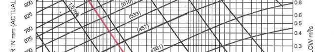


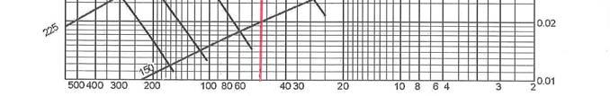
163 Pipe Flow Calculation (note: chart relates to concrete pipes) Source: Compliance Document for New Zealand Building Code Clause E1 Surface Water 163
KAPITI COAST DISTRICT COUNCIL SUBDIVISION AND DEVELOPMENT PRINCIPLES AND REQUIREMENTS
 KAPITI COAST DISTRICT COUNCIL SUBDIVISION AND DEVELOPMENT PRINCIPLES AND REQUIREMENTS 2005 SCHEDULE OF CHANGES Amendment No. Subject Part No. Paragraph Page Date 1 2 3 4 5 6 7 8 9 10 11 12 13 14 15 16
Hastings District Council. Engineering Code of Practice
 Engineering Code of Practice 2011. Schedule of Changes Amendment No: Subject Part No. Paragraph Page Date 1 First Draft Published Sept 2008 2 Second Draft Published Jan 2009 3 Third Draft Published April
General A. General A.1 Activities Not Specifically Provided For A.2 Temporary Activities... 3
 Section Contents General... 2 4A. General... 2 4A.1 Activities Not Specifically Provided For... 2 4A.2 Temporary Activities... 3 4A.3 Activities on the Surface of Water... 6 4A.4 Status of Roads... 7 4A.5
Subdivision and Development Principles and Requirements 2014
 Subdivision and Development Principles and Requirements 2014 Version: 2014 Page 1 of 65 Contents Part One: Development Concepts 3 1. General 3 2. Development Plans 4 3. Development Contributions 6 4. Check
Appendix 9 - Engineering Performance Standards
 Appendix 9 - Engineering Performance Standards A9.1 Introduction A9.1.1 This Appendix contains standards that apply to the subdivision of land. It is referred to in the Subdivision Rules for the Living,
22.1 ISSUES OBJECTIVES POLICIES RULES PERFORMANCE STANDARDS 10
 22 NETWORK UTILITIES 22.1 ISSUES 3 22.2 OBJECTIVES 4 22.3 POLICIES 4 22.4 RULES 6 22.5 PERFORMANCE STANDARDS 10 Whanganui District Plan (15 January 2018) Chapter 22 Network Utilities 22-1 22 NETWORK UTILITIES
subdivision INFILL SUBDIVISION ASSESSMENT CRITERIA RULES
 Safety and Heritage RULES 3.0 General The following rules shall apply to the of land situated in the Living Environment where the is of existing sites either up to 1ha in net site area or which creates
PART 5D - NATURAL HAZARDS
 CONTENTS...PAGE 5D.1 CONTENT AND STRUCTURE...3 5D.2 RESOURCE MANAGEMENT ISSUES...3 5D.3 RESOURCE MANAGEMENT OBJECTIVE AND POLICIES...4 5D.4 RESOURCE MANAGEMENT STRATEGY...4 5D.5 IMPLEMENTATION...4 5D.6.RULES
Natural Hazards Natural Hazards Explanatory Statement Significant Issues Objectives and Policies...
 Section Contents Natural Hazards... 2 8. Natural Hazards... 2 Explanatory Statement... 2 8.1 Significant Issues... 3 8.2 Objectives and Policies... 3 8.3 Activity Lists... 4 8.4 Matters of Control... 7
subdivision BUSH LIVING ENVIRONMENT ASSESSMENT CRITERIA RULES
 RULES 10.0 General The following rules apply to Subdivision of land within the Bush Living Environment except that area identified as Titirangi Subdivision Area 1 and Titirangi-Laingholm Subdivision Area
9 Cross Boundary Processes
 Auckland Regional Council 9-1 9 Cross Boundary Processes 9.1 Introduction Section 67(2)(f) of the RMA states: A regional plan may state the processes for dealing with issues (i) That cross local authority
S e c t i o n S u b d i vision
 S e c t i o n 2. 6 - S u b d i vision Subdivision is a process of defining and redefining land parcel boundaries and can provide a framework for future land use and development. Integrated, well planned
74 Subdivision Rules - Business 1, 2, 3, 4, Town Basin, Marsden Point Port, Port Nikau and Airport Environments
 74 Subdivision Rules - Business 1, 2, 3, 4, Town Basin, Marsden Point Port, Port Nikau and Airport 74.1 Introduction This chapter contains subdivision rules for the Business 1, 2, 3, 4, Town Basin, Marsden
73 Subdivision Rules - Countryside and Coastal Countryside Environments
 73 Subdivision Rules - Countryside and Coastal Countryside Environments 73.1 Introduction This section contains subdivision rules for the Countryside and Coastal Countryside Environments. Additional subdivision
5.9 MARAE DEVELOPMENT ZONE
 5.9 MARAE DEVELOPMENT ZONE 5.9.1 ZONE PURPOSE (1) The provision of a specific zone in which Maori people can undertake ongoing development of their culture, traditions and social infrastructure, is one
10 Network Utilities Introduction Kaipara District Council Engineering Standards Resource Management Act 1991 Requirements
 10 Network Utilities [ENV-2011-AKL-000250 Meridian Energy Ltd. renewable energy resources] 10.1 Introduction The Kaipara District provides for a range of important local and regional strategic assets including
2 EARTHWORKS AND GEOTECHNICAL REQUIREMENTS
 Section 2 Earthworks and Geotechnical Requirements 2 EARTHWORKS AND GEOTECHNICAL REQUIREMENTS CONTENTS 2 EARTHWORKS AND GEOTECHNICAL REQUIREMENTS... I 2.1 Introduction... 2-1 2.1.1 Objectives... 2-1 2.1.2
subdivision WORKING ENVIRONMENT AND COMMUNITY ENVIRONMENT RULES ASSESSMENT CRITERIA
 Character, Mauri, Amenity Values, Neighbourhood Character, Health & Safety and Heritage RULES ASSESSMENT CRITERIA 5.0 General The following rules shall apply to the of land situated in the Community Environment
1 INTRODUCTION TO THE PLAN
 1 INTRODUCTION TO THE PLAN 1.1 Setting the Scene 1.1.1 What is a District Plan? The District Plan (the Plan) must be prepared, implemented and administered to assist the Council in meeting its responsibilities
1 INTRODUCTION TO THE PLAN
 1 INTRODUCTION TO THE PLAN 1.1 Setting the Scene 1.1.1 What is a District Plan? The District Plan (the Plan) must be prepared, implemented and administered to assist the Council in meeting its responsibilities
Consent Steps Assessing the Application and Assessment of Environmental Effects
 2017 Consent Steps Assessing the Application and Assessment of Environmental Effects Assessing the Application and Assessment of Environmental Effects This guidance has been updated to include the changes
Rural-Residential Rural-Residential Explanatory Statement Significant Issues Objectives and Policies...
 Section Contents Rural-Residential... 2 16. Rural-Residential... 2 Explanatory Statement... 2 16.1 Significant Issues... 2 16.2 Objectives and Policies... 3 16.3 Activity Lists... 3 16.4 Activity Performance
TAUPO DISTRICT COUNCIL CODE OF PRACTICE. For DEVELOPMENT OF LAND
 TAUPO DISTRICT COUNCIL CODE OF PRACTICE For DEVELOPMENT OF LAND Adopted by Taupo District Council on 29 September 2009. To be read in Conjunction with NZS 4404: 2004 Land Development and Subdivision Engineering.
7. NATURAL HAZARDS 7.1 SECTION INTRODUCTION
 7. NATURAL HAZARDS 7.1 SECTION INTRODUCTION 7.1.1 The Resource Management Act empowers Council to control any actual or potential effects of the use, development, or protection of land for the purpose
2. The report gives a brief history of the project, including the results of internal and external consultation with stakeholders.
 3. INFRASTRUCTURE DESIGN STANDARD General Manager responsible: Officer responsible: Author: General Managers of City Environment, Capital Programme, and Regulation and Democracy Services, DDI: 941-8608,
Chapter 21 Stormwater Management Bylaw
 Chapter 21 Stormwater Management Bylaw SECTION 1. PURPOSE The purpose of this Bylaw is to: implement the requirements of the National Pollutant Discharge Elimination System (NPDES) General Permit for Storm
Division 15 Earthworks Code (including Lot Filling)
") Division 15 Earthworks Code (including Lot Filling) 12.15.1 Earthworks Code (1) The provisions in this division comprise the (2) They are compliance with the Earthworks Code (Section 12.15.2); overall
Division 15 Earthworks Code (including Lot Filling) 12.15.1 Earthworks Code (1) The provisions in this division comprise the (2) They are compliance with the Earthworks Code (Section 12.15.2); overall
Ordinance No Lot Surface Drainage
 Ordinance No. 35-2008 - Lot Surface Drainage The Township has adopted a new Lot Surface Drainage Ordinance which amends Chapter 170, Article IX, Subdivision and Site Plan Review by adding a new Section
Palmerston North City Council Policy
 Palmerston North City Council Policy PRESSURE SEWER S YSTEMS POLICY - DRAFT SEPTEMBER 2018 Oasis 8384024 Palmerston North City Council Pressure Sewer Systems Policy September 2018 1 Introduction... 3 2
13 Section 32 Summary for the Residential Chapter
 13 Section 32 Summary for the Residential Chapter The purpose of this section is to present a summary of the evaluation of the objectives, policies and methods of the Residential Zone Chapter of the Proposed
Report for Agenda Item: 2
 QLDC Council 28 September 2017 Department: Planning & Development Report for Agenda Item: 2 Stage 2 Proposed District Plan Notification Purpose The purpose of this paper is to present those parts of Stage
3.0 Planning and Submittal Requirements
 October 2003, Revised February 2005 Chapter 3.0, Planning and Submittal Requirements Page 1 3.0 Planning and Submittal Requirements 3.1 Drainage Studies and Drawings The City of Greenwood Village (Village)
PART 8 SUBDIVISION. CITY OF AUCKLAND - DISTRICT PLAN HAURAKI GULF ISLANDS SECTION - OPERATIVE 1996 Page 1 updated 10/03/11
 PART 8 SUBDIVISION HAURAKI GULF ISLANDS SECTION - OPERATIVE 1996 Page 1 PART 8 - SUBDIVISION CONTENTS...PAGE 8.0 INTRODUCTION... 3 8.1 CONTENT AND STRUCTURE... 3 8.2 RESOURCE MANAGEMENT ISSUES... 4 8.3
CHRISTCHURCH CITY COUNCIL. Environmental Services Unit. SUBDIVISION BULLETIN NO 7 (6 February 2006)
") CHRISTCHURCH CITY COUNCIL Environmental Services Unit SUBDIVISION BULLETIN NO 7 (6 February 2006) SB7 New Policy and Procedure for the Construction of Property Access (Rights of Way, Common Property and
CHRISTCHURCH CITY COUNCIL Environmental Services Unit SUBDIVISION BULLETIN NO 7 (6 February 2006) SB7 New Policy and Procedure for the Construction of Property Access (Rights of Way, Common Property and
Works, services and infrastructure code
 9.4.11 Works, services infrastructure code 9.4.11.1 Application (1) This code applies to assessable development identified as requiring assessment against the Works, services infrastructure code by the
E1. Water quality and integrated management
 E1. Water quality and integrated management E1.1. Introduction The National Policy Statement for Freshwater Management, the New Zealand Coastal Policy Statement and this Plan seek to improve the integrated
1006 UTILITIES, STREET LIGHTS, WATER SUPPLY, SEWAGE DISPOSAL, SURFACE WATER MANAGEMENT, AND EROSION CONTROL
 1006 UTILITIES, STREET LIGHTS, WATER SUPPLY, SEWAGE DISPOSAL, SURFACE WATER MANAGEMENT, AND EROSION CONTROL 1006.01 GENERAL STANDARDS A. The location, design, installation, and maintenance of all utility
The natural hazard types that have been identified within the City include the following:
 Chapter 62 NATURAL HAZARDS 62.1 INTRODUCTION Napier City, like many other cities within New Zealand, is subject to the effects of natural hazards. Since the enactment of the Resource Management Act, the
Environment Canterbury regional council works with the people of Canterbury to manage the region s air, water and land. We are committed to the
 How to apply Environment Canterbury regional council works with the people of Canterbury to manage the region s air, water and land. We are committed to the sustainable management of our environment while
I433. Pukekohe Hill Precinct
 I433. Pukekohe Hill Precinct I433.1. Precinct Description The Pukekohe Hill Precinct covers approximately 196 hectares of land and is located at the southern urban edge of Pukekohe. Land use, development
10.1 OBJECTIVES. Note: Refer to Section 6 for Issues, Methods of Implementation, and Environmental Results Anticipated.
 SECTION 10 : RURAL SETTLEMENTS Note: Refer to Section 6 for Issues, Methods of Implementation, and Environmental Results Anticipated. 10.1 OBJECTIVES The objectives contained in this section are specific
5.2 Discharges to water and land
 5.2 Discharges to water and land Interpretation If an activity is covered by more than one rule, then the rule that applies is the rule that is more specific for the relevant activity, area or resource,
H28. Special Purpose Quarry Zone
 H28. Special Purpose Quarry Zone H28.1. Zone description Mineral resources are important to Auckland s economy and development. The Special Purpose Quarry Zone provides for significant mineral extraction
Kaipara District Plan: Proposed Plan Change 2 - Fire Safety Rules SUMMARY
 Kaipara District Plan: Proposed Plan Change 2 - Fire Safety Rules SUMMARY Kaipara District Council is proposing changes to the Fire Safety Rules in the Kaipara District Plan. Research has been undertaken
general natural area GUIDELINES TO THE RULES This section updated September 2015
 This section updated September 2015 GUIDELINES TO THE RULES 2 The General Natural Area Rules apply to activities on land within the General Natural Area as shown on the Natural Areas Maps. This includes
The Proposed Auckland Unitary Plan (notified 30 September 2013)
") ART 3 REGIONAL AND DISTRICT RULES»Chapter H: Auckland wide rules»4 Natural resources» 4.14 Stormwater management Introduction The roposed Auckland Unitary lan (notified 30 September 2013) This section
ART 3 REGIONAL AND DISTRICT RULES»Chapter H: Auckland wide rules»4 Natural resources» 4.14 Stormwater management Introduction The roposed Auckland Unitary lan (notified 30 September 2013) This section
Last amended 3 May 2011 Earthworks Operative 27/07/2000
 29 Earthworks 29.1 Introduction Earthworks are essential to the development of the City. They create the areas of level land used for living, business and recreation, and the even gradients for paths and
UTE.1 Urban Transition Environment
 UTE.1 Urban Transition Environment Index UTE.1 Urban Transition Environment UTE.1.1 UTE.1.2 UTE.1.3 UTE.1.4 UTE.2 Land Use Description and Expectations Eligibility Rules Information Requirements Objectives
14 NATURAL HAZARDS Background Resource Management Issues
 14 NATURAL HAZARDS 14.1 Background The particular geology, hydrology and topography of the Hutt Valley make Upper Hutt vulnerable to a variety of natural hazards. Earthquakes and flooding are the most
14 Business: Commercial and Industrial Chapter
 14 Business: Commercial and Industrial Chapter s of Section 14.10 in this Chapter. If you don t se standards your proposal, will need Resource Consent to allow you to do it. 14.1 Introduction / Resource
MIXED ACTIVITY ZONE. Chapter 4. Mixed Activity Zone
 Chapter 4 Mixed Activity Zone 4. MIXED ACTIVITY ZONE 4.1 RESOURCE MANAGEMENT ISSUES 1. Activities adjoining main arterial roads can adversely affect the safety, sustainability and efficiency of the network.
National Level AN EVERYDAY GUIDE TO THE RMA SERIES 1.4
 National Level Guidance and Processes AN EVERYDAY GUIDE TO THE RMA SERIES 1.4 AN EVERYDAY GUIDE TO THE RMA Series Overview 1.1 1.2 1.3 1.4 Getting in on the Act Resolving Resource Management Act Concerns
Thinking about developing or building on land with ponding or drainage issues?
 Thinking about developing or building on land with ponding or drainage issues? Much of the Kāpiti Coast is low-lying and subject to flooding, ponding or drainage issues. We need to pay careful attention
ZONING ORDINANCE FOR THE ZONED UNINCORPORATED AREAS ARTICLE 1500 OF PUTNAM COUNTY, WEST VIRGINIA Page 149 ARTICLE 1500 DRAINAGE AND STORM SEWERS
 OF PUTNAM COUNTY, WEST VIRGINIA Page 149 ARTICLE 1500 DRAINAGE AND STORM SEWERS 1500.01 GENERAL REQUIREMENTS 1500.02 NATURE OF STORM WATER FACILITIES 1500.03 DRAINAGE EASEMENTS 1500.04 STORM WATER MANAGEMENT
Strengthened Regulations
 Building Regulations review Strengthened Regulations The Department of Environment, Land, Water and Planning has identified a number of changes to the Building Regulations to improve consumer protection
Regarding the issuing of a building consent for the separation of surface water drainage to 39 and 39A Towai Street, Kohimarama, Auckland
 Determination 2013/001 1 Regarding the issuing of a building consent for the separation of surface water drainage to 39 and 39A Towai Street, Kohimarama, Auckland 1. The matters to be determined 1.1 This
Earthquake-Prone Buildings Policy
 Earthquake-Prone Buildings Policy Introduction and Purpose The purpose of this Policy is to balance out the need to address earthquake risk and other priorities, taking account of the social, cultural
This part of the Plan explains what a District Plan is and provides a user friendly guide.
 This part of the Plan explains what a District Plan is and provides a user friendly guide. If you have any questions about this Plan and how it might affect a project you are contemplating, then you are
Form 1: Application for resource consent
 Form 1: Application for resource consent All sections must be completed in full and accompanied by the initial fixed application fee (see section 11) and the relevant activity form (see section 7). Failure
Guidance notes for developers
 Guidance notes for developers - adoption of sewers. Section 104 of the Water Industry Act 1991 Foreword These guidelines are designed to be used in conjunction with the current version of Sewers for Adoption
Hazardous Substances. 9. Hazardous Substances. Explanatory Statement
 Hazardous Substances 9. Hazardous Substances Explanatory Statement The Western Bay of Plenty District is predominantly rural land in farming and horticulture and has a number of small urban centres containing
Most of Kaipara s District is Rural and this Chapter sets out how this area will be managed through the District Plan
 12 Rural Chapter 12.1 Introduction / Resource Description The majority of land in District falls within Rural Zone. Kaipara s economy has historically been driven by pastoral farming and to a lesser extent
E36. Natural hazards and flooding
 E36. Natural hazards and flooding E36.1. Background Auckland is affected by natural hazards including: those that occur frequently such as flooding, coastal erosion (including the effects of sea level
11 Infrastructure, Services and Associated Resource
 11 Infrastructure, Services and Associated Resource Use The primary objectives (set out in Chapter 2) that this Chapter implements are Objectives 2.8 Strong Communities; 2.13 Infrastructure; 2.14 Access
Ibstock plc. (the Company) Audit Committee - Terms of Reference
 Audit Committee - Terms of Reference") Ibstock plc (the Company) Audit Committee - Terms of Reference 1. PURPOSE 1.1 The role of the Audit Committee (the Committee) is to: monitor the integrity of the financial statements and related announcements
Ibstock plc (the Company) Audit Committee - Terms of Reference 1. PURPOSE 1.1 The role of the Audit Committee (the Committee) is to: monitor the integrity of the financial statements and related announcements
The approach to managing natural hazards in this Plan is to: set out a clear regional framework for natural hazard management,
 9 Natural Hazards 9.1 Scope and Background This chapter establishes an overall framework for natural hazard management under the RMA. It also sets out the division of responsibilities between the Regional
IMPLEMENTATION GUIDELINE NO. 19 Vegetation Retention
 IMPLEMENTATION GUIDELINE NO. 19 Vegetation Retention Date of Council Resolution This guideline was adopted by Council on 12 December 2007 and takes effect on 19 December 2007, in accordance with section
WESTERN WATER DESIGN AND CONSTRUCTION GUIDELINES FOR SUBDIVISIONAL WORKS
 WESTERN WATER DESIGN AND CONSTRUCTION GUIDELINES FOR SUBDIVISIONAL WORKS December 2014 Page 1 Table of contents 1 ROLES AND RESPONSIBILITES... 3 2 GENERAL DESIGN STANDARDS... 8 2.1 Design presentation...
A Guide to the Municipal Planning Process in Saskatchewan
 A Guide to the Municipal Planning Process in Saskatchewan An overview of the municipal planning, development permit and the subdivision approval processes in Saskatchewan July 2016 Prepared By: Community
APEC ENGINEER FRAMEWORK
 PART 1 APEC ENGINEER FRAMEWORK 1. Purpose The APEC Engineer Manual provides overall guidance to participating APEC economies for the operation of APEC Engineer Registers. The Manual includes a description
PROPOSED Plan Change 10: Lake Rotorua Nutrient Management COUNCIL DECISIONS. August 2017
 Version 8.0 August 2017 PROPOSED Plan Change 10: Lake Rotorua Nutrient Management COUNCIL DECISIONS Clear copy August 2017 This version shows the changes to the Proposed Plan Change 10 publicly notified
Revised functions for Resource Management Act 1991 decision-makers
 RESOURCE LEGISLATION AMENDMENTS 2017 FACT SHEET 2 Revised functions for Resource Management Act 1991 decision-makers This is part of a series of 16 fact sheets that give an overview of recent resource
14 NATURAL HAZARDS Background Resource Management Issues
 14 NATURAL HAZARDS 14.1 Background The particular geology, hydrology and topography of the Hutt Valley make Upper Hutt vulnerable to a variety of natural hazards. Earthquakes and flooding are the most
#24. Submission by Transpower NZ Limited on the Upper Hutt City Council Proposed Plan Change 42 Mangaroa and Pinehaven Flood Hazard Extents 2017
 Submission by Transpower NZ Limited on the Upper Hutt City Council Proposed Plan Change 42 Mangaroa and Pinehaven Flood Hazard Extents 2017 8 May 2017 ADDRESS FOR SERVICE Transpower New Zealand Limited
The Gym Group plc. (the Company ) Audit and Risk Committee - Terms of Reference. Adopted by the board on 14 October 2015 (conditional on Admission)
 Audit and Risk Committee - Terms of Reference. Adopted by the board on 14 October 2015 (conditional on Admission)") The Gym Group plc (the Company ) Audit and Risk Committee - Terms of Reference Adopted by the board on 14 October 2015 (conditional on Admission) 1. BACKGROUND The board of directors of the Company (the
The Gym Group plc (the Company ) Audit and Risk Committee - Terms of Reference Adopted by the board on 14 October 2015 (conditional on Admission) 1. BACKGROUND The board of directors of the Company (the
7.7 HAZARDOUS SUBSTANCES AND CONTAMINATED LAND
 7.7 HAZARDOUS SUBSTANCES AND CONTAMINATED LAND 7.7.1 BACKGROUND (1) Hazardous substances are used by the agriculture, horticulture, forestry and industrial sectors, as well as the domestic sector (but
4a RESIDENTIAL ENVIRONMENT
 Page 1 of Section 4a Section 4a: Rules and Standards Environment Updated 20 March 2015 4a RESIDENTIAL ENVIRONMENT Section Index: 4a.1 Performance Standards and Development Controls 4a.2 General Rules 4a.3
1 INTRODUCTION TO THE PLAN
 1 INTRODUCTION TO THE PLAN 1.1 Setting the Scene 1.1.1 What is a District Plan? The District Plan (the Plan) must be prepared, implemented and administered to assist the Council in meeting its responsibilities
Appendix 3. POLICY & PROCEDURE No
 DEPARTMENT OF PUBLIC WORKS DIVISION: ENGINEERING SERVICES SECTION: ADMINISTRATIVE PAGE NO: 1 OF 10 REVISION NO: 3 DATE: 1995 05 01 ESTABLISHED: 1986 03 03 Appendix 3 POLICY & PROCEDURE No. 2.3.1-020 TITLE:
supports the needs of the community and businesses to identify and advertise businesses and activities; and
 8A.3 SIGNS 8A.3.1 Introduction to Signs This chapter recognises the role of signs in communicating information for businesses and the community. It provides a framework to manage the effects of signs in
RURAL CONSERVATION ZONE
 Chapter 37 RURAL CONSERVATION ZONE INTRODUCTION This Chapter contains rules managing land uses in the. The boundaries of this zone are shown on the Planning Maps. All rules apply throughout the unless
Hazardous Substances Hazardous Substances Explanatory Statement Significant Issues Objective and Policies...
 Section Contents Hazardous Substances... 2 9. Hazardous Substances... 2 Explanatory Statement... 2 9.1 Significant Issues... 3 9.2 Objective and Policies... 3 9.3 Activity Lists... 4 9.4 Quantity thresholds
Building Consent / PIM Application
 Building Consent / PIM Application Applying for a building consent: The basic information WHAT IS A BUILDING CONSENT? A building consent is written authority from the Council to carry out the building
TOWN OF BERKLEY ARTICLE 32 STORM WATER BYLAW
 TOWN OF BERKLEY ARTICLE 32 STORM WATER BYLAW Land development projects and other land use conversions, and their associated changes to land cover, permanently alter the hydrologic response of local watersheds
Chapter 4. Drainage Report and Construction Drawing Submittal Requirements
 4.0 Introduction The requirements presented in this section shall be used to aid the design engineer or applicant in the preparation of drainage reports, drainage studies, and construction drawings for
Report to COUNCIL for information
 18 149 Title: Section: Prepared by: Draft Regional Target for Swimmable Lakes and Rivers Transformation & Relationships Janic Slupski (Senior Policy Advisor) Meeting Date: 5 April 2018 Legal Financial
E36. Natural hazards and flooding
 E36. Natural hazards and flooding E36.1. Background Auckland is affected by natural hazards including: those that occur frequently such as flooding, coastal erosion (including the effects of sea level
APPENDIX 6 RECOMMENDED CONDITIONS SHOULD CONSENT BE GRANTED. RECOMMENDED CONDITIONS LAND USE [RM180023] General Conditions
![APPENDIX 6 RECOMMENDED CONDITIONS SHOULD CONSENT BE GRANTED. RECOMMENDED CONDITIONS LAND USE [RM180023] General Conditions](/thumbs/87/97187216.jpg "APPENDIX 6 RECOMMENDED CONDITIONS SHOULD CONSENT BE GRANTED. RECOMMENDED CONDITIONS LAND USE [RM180023] General Conditions") RECOMMENDED CONDITIONS LAND USE [RM180023] General Conditions No / Title 1 General Accordance Requirement The activity being the establishment and operation of a BP Service Station and Quick Service Restaurant
RECOMMENDED CONDITIONS LAND USE [RM180023] General Conditions No / Title 1 General Accordance Requirement The activity being the establishment and operation of a BP Service Station and Quick Service Restaurant
Kaipara District Plan
 Kaipara District Plan A guide to subdivision in the rural zone The purpose of this brochure is to provide an overview of the types of rural subdivision in the Proposed Kaipara District Plan - Decisions
Standard terms and conditions
 Standard terms and conditions Development Services For the provision of a water service (Water Supply, Wastewater and Drainage) Introduction Under Section 73(2)(a) of the Water Services Act 2012, landowners
APPLICATION FOR LANDUSE RESOURCE CONSENT
 (Section 88 of the Resource Management Act 1991) Form 9 APPLICATION FOR LANDUSE RESOURCE CONSENT I,.. (full name) being the applicant residing at the below address, apply to the Waitaki District Council
MINISTRY DIRECTIVE. Program: Provincial Highway Management Directive: B-014. Issuing Authority: Director, Highway Standards Branch
 Ministry of Transportation Ministry of Transportation Ministère des Transports MINISTRY DIRECTIVE Program: Provincial Highway Management Directive: B-014 Issuing Authority: Director, Highway Standards
CONSTRUCTION MANAGER
 The South African Council for the Project and Construction Management Professions CONSTRUCTION MANAGER IDENTIFICATION OF WORK AND SCOPE OF SERVICES FOR CONSTRUCTION MANAGERS REGISTERED IN TERMS OF THE
Rural Residential Development Control Plan
 1 Rural Residential Development Control Plan Council of the City of Greater Lithgow 180 Mort Street, Lithgow NSW 2790 Telephone: (02) 6354 1077 2 EXPLANATORY NOTE: Council has been aware for some time
TOWN OF MANCHESTER PLANNING AND ZONING COMMISSION Subdivision Application Minimum Submission Requirements
 TOWN OF MANCHESTER PLANNING AND ZONING COMMISSION Subdivision Application Minimum Submission Requirements This checklist is to be completed and submitted with all Subdivision Applications. The Town reserves
E36. Natural hazards and flooding
 E36. Natural hazards and flooding E36.1. Background Auckland is affected by natural hazards including: those that occur frequently such as flooding, coastal erosion (including the effects of sea level
RPE.3.4. Rural Production Environment. Index. RPE.1.1 Description and Expectations
 RPE.1 Index RPE.1 RPE.1.1 RPE.1.2 RPE.1.3 RPE.1.4 RPE.2 RPE.2.1 RPE.2.2 RPE.2.3 RPE.3 Landuse Description and Expectations Objectives Policies Guidance Note Eligibility Rules Notification Rules Discretionary
Informa PLC TERMS OF REFERENCE AUDIT COMMITTEE. Adopted by the Board on
 Informa PLC TERMS OF REFERENCE AUDIT COMMITTEE Adopted by the Board on 12 th December 2017 CONTENTS Constitution and Purpose... 1 1. Membership... 1 2. Secretary... 3 3. Quorum... 3 4. Frequency of Meetings...
Informa PLC TERMS OF REFERENCE AUDIT COMMITTEE. Effective 1 st January
 Informa PLC TERMS OF REFERENCE AUDIT COMMITTEE Effective 1 st January 2019 CONTENTS Constitution and Purpose... 1 1. Membership... 1 2. Secretary... 3 3. Quorum... 3 4. Frequency of Meetings... 3 5. Notice
A smaller 7.65MW wind farm at Mount Stuart, comprising 9 turbines with a maximum height of 75- metres, was also constructed in 2011.
 3.4. ENERGY 3.4.1. INTRODUCTION The use of energy is of fundamental importance to the development and functioning of modern society. The RMA definition of natural and physical resources includes energy