Illawarra Coal. Dendrobium. DSC Notification Area. Avon and Cordeaux Reservoirs DSC. Notification Area Management Plan
|
|
|
- Magnus Summers
- 5 years ago
- Views:
Transcription


1 Illawarra Coal Dendrobium DSC Notification Area Avon and Cordeaux Reservoirs DSC Notification Area Management Plan
2 Review History Revision Description of Changes Date Monitoring Plan DENMP003 Revision 7 Final Plan for Area 1 01/06/05 Revision 8 Plan updated to include Area 2 30/03/07 Revision 9 Final Plan incorporating Area 2 20/10/07 Revision 10 Rewrite and updated to include Area 3A Incorporate DSC and Water NSW comments Incorporate additional DSC and Water NSW comments Revised Mine Plan Area 3A and DSC Comments Contingency Plan DENMP /11/09 15/01/10 10/03/10 06/04/10 Revision 1 Final revision for Area 1 20/07/05 Revision 2 Draft Revision to Accompany Area 2 Application 30/03/07 Revision 3 Final Revision to incorporate Area 2 20/10/07 Revision 4 Rewritten and updated to incorporate Area 3A Incorporate DSC and Water NSW comments Incorporate additional DSC and Water NSW comments Revised Mine Plan Area 3A and DSC Comments 27/11/09 14/01/10 10/03/10 06/04/10 Revision 5 Revised to incorporate contingency for Dendrobium Dyke 22/02/11 Closure Plan DENMP0030 Revision 1 Final for Area 1 01/06/05 Revision 2 Draft incorporating Area 2 30/03/07 Revision 3 Final incorporating Area 2 20/10/07 Revision 4 Revision 0 Draft 2 Revision 0 Draft 3 Rewritten and updated to incorporate Area 3A Incorporate DSC and Water NSW Comments Incorporate additional DSC and Water NSW Comments Revised Mine Plan Area 3A and DSC Comments Management Plans DENMP0078 Monitoring, Contingency and Closure Plans were updated after an annual review and then consolidated into one document Revised to incorporate results of Annual Review, revised TARP, updated responsibilities, updated contacts and to include Area 3B 27/11/09 14/01/10 10/03/10 06/04/10 26/9/11 5/10/12 Revision 0 Final Endorsed by DSC 12/12/12 Revision 1 Draft 1 Revised to incorporate results of Annual Review 22/05/14 Revision 1 Revised to incorporate DSC correspondence 15/07/14 25/11/14 Revision 2 Revised following review of Management Plan 17/08/15 Revision 3 Rewrite and Update following review 0910/15 Page 2 of 72
3 CONTENTS 1 CONTACT LIST INTRODUCTION PURPOSE SCOPE DEFINITIONS HAZARD IDENTIFICATION MONITORING MANAGEMENT PLAN SCOPE CONTROL PROCEDURES PRINCIPAL MONITORING CONTROLS Underground Water Sampling and Analysis Underground Water Balance SECONDARY MONITORING CONTROLS In Seam Drilling Underground Geological Mapping Surface Geological Mapping Environmental Monitoring at the Mining Face Groundwater Monitoring Subsidence Monitoring Statistical Reports Compliance Reports Monitoring, Reporting and Extraction Schedule Liaison Officer Face Location Dendrobium Dyke Monitoring CONTINGENCY PLAN SCOPE CONTROL PROCEDURES Principal Monitoring Controls Secondary Monitoring Controls PUMPING CONTINGENCY ACTIONS Grouting, PUR Injection and Similar Activities Sealing TRIGGER ACTION RESPONSE PLANS PRINCIPAL TARP FLOW CHART PRINCIPAL TARP SECONDARY TARP CLOSURE PLAN SCOPE ASSUMPTIONS CONTROL PROCEDURES Water Inflow Scenario Analysis HYDRAULIC SEAL DESIGN SEALING STRATEGY NOTES PERMANENT HYDRAULIC SEAL DESIGN PERMANENT AND VENTILATION SEAL SITES...51 Page 3 of 72
4 9.7.1 Permanent Seal Site Permanent Seal Site Ventilation Seal Sites MONITORING TRIGGERS AND RESPONSES RESPONSIBILITY AND AUTHORITY REVIEW TEAM INCIDENT MANAGEMENT TEAM GENERAL MANAGER PLANNING MANAGER ENGINEERING MANAGER PRODUCTION MANAGER MANAGER OF MINING ENGINEERING WATER BALANCE ENGINEER MINING CONSULTANT/GEOLOGIST MINE SURVEYOR CONTROL OFFICER WATER QUALITY CONSULTANT GEOTECHNICAL ENGINEER UNDERGROUND MINING OFFICIALS TRAINING COORDINATOR MANAGER SUBSIDENCE ENGINEERING HYDROGEOLOGICAL CONSULTANT TRAINING & COMPETENCY DSC CONTINGENCY AWARENESS DUTIES AND RESPONSIBILITIES DOCUMENT CONTROL REVIEW RECORD KEEPING AND CONTROL COMMUNICATION AND CONSULTATION ASSOCIATED DOCUMENTATION AND REFERENCES PLANS APPENDIX A APPENDIX B (ONLY IF REQUIRED)...70 Page 4 of 72
5 1 CONTACT LIST Organisation Primary Contact Number Alternate Contact Number Dams Safety Committee Bill Ziegler (Manager Mining Impacts) (02) (W) Steve Knight (Executive Engineer) (02) (W) (M) Sydney Catchment Authority Andrew George (Executive Manager Strategic Engineering) Marlo Vergara (Senior Engineer Mining and Services) (02) (W) (02) (F) District Mines Inspector Dave Gordon Allan Phillips (02) (W) (M) Bill Barraclough (02) (W) (M) Manager of Mining Engineering Joel Plavecky (02) (W) (M) Peter Brannon (02) (W) (M) Engineering Manager Corey Potter (02) (W) (M) Greg Gleeson (02) (W) Planning Manager Peter Brannon (02) (W) (M) Gary Brassington (02) (W) (M) General Manager Wayne Price (02) (W) (M) Peter Brannon (02) (W) (M) Dendrobium Control Control Officer (02) (M) N/A N/A Mine Surveyor Daniel Baker (02) (W) (M) Gavin Bridge South32 Illawarra Coal Gary Brassington (02) (W) (M) Richard Walsh (02) (W) (M) Minova (Ground Consolidation)Orica Rob Holstein (Applications Manager) (M) Steve Ryan (Senior Supervisor) (M) Valley Longwall Drilling P/L Frank Hungerford (Technical Services Manager) (M) Justin Tredinnick (NSW Operations Manager) (M) NATA Water Testing Authority ALS Environmental (02) (W) (02) (F) ECOWISE (02) Water Quality Consultant Dr. Steve Short (02) (W) (M) Dr. Alexandra Golab Charlie Pierce Sydney Water (M) (02) (W) (M) Groutech Norm Howell (07) N/A N/A Multigrout Bruce Grant (Managing Director) (03) (W) (M) N/A N/A Page 5 of 72
6 2 INTRODUCTION South32 Illawarra Coal is mining the Wongawilli Seam in Area 3B, workings include the development of roadways and longwall extraction. Extraction of Longwalls 9 and 10 are complete in Area 3B and Longwall 11 commenced extraction in January Dendrobium has previously extracted Longwalls 1 and 2 in Area 1, Longwalls 3 to 5 in Area 2 and Longwalls 6 to 8 in Area 3A. Area 3B is located to the east of Lake Avon, between the Native Dog Creek arm of the Lake and Wongawilli Creek, and is partially located within the Dams Safety Committee (DSC) Notification Area for Avon Reservoir (DSC Notification Area). Dendrobium has DSC approval for Longwall 11 and Department of Trade and Investment (DTI) and Department of Planning and Environment (DoPE) Subsidence Management Plan (SMP) Approval for the extraction. As was the case for Areas 1, 2 and 3A, none of the current or proposed Area 3B mine workings underlie any dam wall and no longwall extraction is undertaken below stored waters of Avon or Cordeaux Reservoirs. Longwalls 9 and 10 are outside the Avon DSC Notification Areas and Longwall 11 is just inside the Area (refer to Plan 1). Longwalls 12 to 18 are set back from the Avon Reservoir Full Storage Level (FSL) by 300m, 240m, 275m, 215m, 215m, 230m and 250m respectively. The development headings known as Nebo Mains between Areas 1 and 2 and North West Mains between Areas 2 and 3A pass directly below the stored waters of the Cordeaux Reservoir. In order to gain and maintain approval for mining within the DSC Cordeaux Notification Area, Dendrobium Coal Pty Ltd is required to implement the Avon and Cordeaux Reservoir DSC Notification Area Management Plans (Plan). Revision 0 of the Plan was developed to meet the requirements of the Cordeaux Notification Area and the future requirements associated with mining in the Avon Notification Area. Revision 1 of this Plan has been updated to incorporate learning s from the extraction of Longwalls 9 and 10 in Area 3B. Revision 2 follows a full review and audit of the Management Plan. This Plan describes the monitoring, contingency and closure requirements for the Avon and Cordeaux Reservoirs Notification Areas and has been developed in accordance with the relevant provisions of the Dams Safety Act 1978, to minimise the loss of reservoir water as a result of mining within the Notification Areas. This Plan will be applied in conjunction with the Mine Health and Safety Management System and may be influenced by or have influence on other Management Plans and procedures, including: DSC4C Mining Near Prescribed Dams Management and Monitoring Matters DSC4D Mining Near Prescribed Dams Contingency Plans Page 6 of 72

7 DSC Annexure D and D1 conditions and Annexure E for the relevant Avon and Cordeaux Reservoir DSC Notification Areas Inrush Management Plan (IMP) Strata Failure Management Plan (SFMP) SMP Figure 1 describes the interrelationship between the Management Plans. 3 PURPOSE The purpose of the Avon and Cordeaux Reservoirs DSC Notification Area Management Plans are to define the standards, procedures and responsibilities required to: Clearly describe the monitoring requirements to detect potential impacts on the Cordeaux and Avon Reservoirs, Maintain a system for effectively managing the risk of inflow of stored water into the Mine, and To protect the long term security of the dams and stored waters from any deterioration that may be caused directly or indirectly by operations associated with Dendrobium Mine. The Cordeaux and Avon Reservoirs, DSC Notification Areas and mine workings are shown in Plan 1. Page 7 of 72

8 PLAN 1 Page 8 of 72
9 4 SCOPE This Plan applies to all development and longwall extraction i.e. first and second workings within the DSC Avon and Cordeaux Reservoirs Notification Areas and other underground areas and operations at Dendrobium Mine (existing and proposed Dendrobium Mine workings - Plan 1). 5 DEFINITIONS Abnormal Inflow a confirmed or suspected flow of water into the Mine workings from any source that is in excess of that normally attributable to the water make from the seam, surrounding strata, rainfall events and mining operations, during the drivage of roadways or longwall operations. In particular, any flow of water from a geological structure encountered during mining or a flow that commenced in outbye workings for no apparent reason. ATM Authority to Mine CI Chief Inspector Cross Measure Hole a hole drilled from one seam to intersect another seam to determine interburden thickness or to drain water DCI District Check Inspector DTI Department of Trade and Investment (now DTI) DSC Dams Safety Committee DSC ICZ Inrush Control Zone an area of workings delineated by the DSC that require further investigation prior to gaining approval to develop or extract in that area. This exists only within the DSC notification area. DTIRIS NSW Government Department of Transport, Investment and Regional Infrastructure and Services formerly DII and now DTI DTI NSW Government Department of Trade and Investment formerly DTIRIS In-seam drilling drilling conducted from and within the working seam, in advance of mining, to detect or confirm geological features and/or anomalies, determine in-situ gas make, and to identify and quantify water bearing strata. FSL Full Storage Level Geological Structure a geological discontinuity which may be capable of providing a conduit for water or gas into the mine workings, e.g. fault, dyke, diatreme. Page 9 of 72
10 Hydraulic Seals the permanent seals erected for the sealing of the mine either at the cessation of mining or should contingency measures fail to control stored water inflows. IMP Inrush Management Plan IM Inspector of Mines Inflow Ingress of water that is of operational nuisance value and may be high velocity, low volume, or high potential volume but of low delivery rate. Inflows in relation to water emanating from Avon or Cordeaux Reservoir, whilst insignificant from an inrush perspective, are critical in relation to DSC requirements and are addressed in the Contingency Plan. Inrush unplanned or uncontrolled flood of liquid, gas or material that has a potential to create a hazard as defined by the Coal Mines Health and Safety Regulations Inrush Control Zone (ICZ) a 50 metre zone of solid strata around a potential source of inrush. Inrush Hazard involves the existence of a significant quantity of water or other fluid material, any material that flows when wet or flammable or noxious gases, all possibly under pressure that can swiftly flow or release into or within an underground coal mine. Long-term Limit (Cordeaux) - the DSC-imposed limit of daily water losses from Cordeaux Reservoir into Dendrobium Mine directly or indirectly resulting from Dendrobium mining operations for the life of the Reservoir following closure of the mine. Long-term Limit (Avon) - the DSC-imposed limit of daily water losses from Avon Reservoir into Dendrobium Mine directly or indirectly resulting from Dendrobium mining operations for the life of the Reservoir following closure of the mine. Man Made Feature shafts, wells, pipelines, tunnels, quarries, repositories, dam or other earthworks. Notification Area is an area determined by the DSC which surrounds a Prescribed Dam and its storage. It is defined by straight lines joining a series of co-ordinates as set out in an order published in the NSW State Government Gazette. The Notification Area is drawn to include the structure (any dam walls and spillways), the stored water, and an area around these within which mining may have an effect on the Prescribed Dam or on the security of its stored water. Prescribed Dam means any dam or proposed dam specified in Schedule 1 of the Dams Safety Act, Principal Monitoring Controls The primary means of defining and initiating a response to abnormal water inflows. Water NSW Previously Sydney Catchment Authority Page 10 of 72
11 SCADA Supervisory Control and Data Acquisition, the computerised system through which realtime data is monitored throughout the mining process. Sealing of the Mine using designed permanent Hydraulic Seals or bulkheads as final seals. Secondary Monitoring Controls Monitoring resulting in triggers that alert Mine Management to the potential for an abnormal inflow and that initiate low level alarms within the Principal Monitoring TARP. Short-term Limit the DSC-imposed limit of daily water losses from the Reservoirs into Dendrobium Mine during the operation of the mine. SFMP Strata Failure Management Plan Stored Water Water within the Reservoirs. Surface Borehole - is a hole drilled from the surface that may or may not intersect the seam being mined. Surface Feature creeks, rivers, ponds, reservoirs TARP Trigger Action Response Plan Temporary Seals the seals erected to control water as part of remediation activities under the Contingency Plan. The seals may be installed to manage water flow while other contingency activities are undertaken e.g. grouting. Ventilation Seals the seals erected during the normal course of operation to isolate a worked out area of the mine. These structures may contain water sampling and monitoring facilities but are not designed to withstand any significant head of water. 6 HAZARD IDENTIFICATION The potential for water inflow to the mine from Cordeaux Reservoir has been the subject of considerable investigation and analysis to assess and mitigate the risk of inflow whilst mining in Areas 1, 2 and 3. The following risk assessments, reviews and gap analysis have been conducted: The Dendrobium Project Critical Risk Management Assessment 2001, Australian Coal Mining Consultants that identified the major inrush risks to the mine. GHD LongMac report June 2004 Hydrogeological Interaction of Underground Coal Mining that reviewed Area 1 potential inflow risks with mining. Hawcroft Miller Swan Consultants Risk Review undertaken in January 2005 that reviewed all data associated with Area 1. Page 11 of 72
12 Hawcroft Miller Swan Consultants Risk Review undertaken in July 2005 to review data and assess the risks associated with the development of Area 2. Hawcroft Miller Swan Consultants Risk Review undertaken in October and December 2005 to review all data associated with Area 2 and update previous findings from Area 1 operations and identify risks associated with operating longwalls in Area 2. AXYS Consulting May 2008 Risk Assessment to review all data associated with Area 3A. HMS Consultants Australia, July 2009 Cordeaux Reservoir DSC Closure, Contingency and Monitoring Management Plan Audit. HMS Consultants Australia, October 2009 Cordeaux Reservoir DSC Closure, Contingency and Monitoring Management Plan Gap Analysis to review all data associated with Area 3A. Notwithstanding previous assessments of Areas 1, 2 and 3 and to assist the Mine identify and control hazards associated with the loss of water and damage to the Reservoirs, the following hazards have been identified as potential causes for loss of water into Dendrobium Mine: Inflow from sub-vertical, through-going geological structure connected to the Reservoirs (such as diatreme, fault, dyke, fault associated with dyke, joint or joint swarm). A specific plan has been prepared for the potential inflow along the Dendrobium Dyke into Area 3A at the request of the DSC; Inflow from low angle through-going geological structure connected to the Reservoirs (faults, sills, bedding, bedding plane shears) resulting from intersection during extraction of longwall panels and goaf formation; Inflow through the longwall caved zone due to: - Intersection with high permeability strata or zones that connect with the Reservoirs, or - Inflow from fractures associated with valley closure and upsidence with high permeability zones, or - Through going structure; Inflow through fractured rockmass associated with igneous intrusions, causing hydrogeological connection with Reservoirs; Inflow via abandoned exploration borehole(s); Underground mining in a regional context impacting on Reservoir walls; Seal bypass or failure as a result of increased head of water against seal or strata failure or leakage around seal resulting in outflow of stored water from the mine portals; Inflow through fractured rock mass associated with igneous intrusions, causing hydrogeological connection with the Reservoirs (e.g. Cordeaux Crinanite); Page 12 of 72
13 Inflow through horizontal shear planes that exist naturally and others that are likely to form as a result of downslope movements associated with mining subsidence; and Failure of the IMP and/or the Contingency Plan to reduce flows to acceptable levels. Prior to the installation of permanent hydraulic seals the Review Team will evaluate all closure options and recommend actions to be authorised by the DSC. The potential for loss of Stored Water from the Avon Reservoir whilst mining Area 3B was considered in a risk assessment held in February 2014 which was conducted by AXYS Consulting. The objective of the assessment was to assist Illawarra Coal control identified risks associated with the mining of Longwalls 12 to 18 which may cause the loss of stored water. The following hazards were identified as potential causes for such losses (Plan 2): Water inflow from the Avon Reservoir into the Dendrobium Mine workings (Approved Plan). Loss of stored water through porous flow outside the influence of mining or fracture flow within the mining induced fracture zone. Water inflow from the Avon Reservoir into the Dendrobium Mine workings (with an extended mine plan option, additional 200m to Longwalls 12-17). Loss of stored water through porous flow outside the influence of mining or fracture flow within the mining induced fracture zone. DF11 Elouera Fault Zone (DF11) acts as a conduit between the Avon Reservoir and the mine workings (development or longwall) resulting in loss of stored water. Aeromag Fault (NW-1) acts as a conduit between the Avon Reservoir and the mine workings (development or longwall) resulting in loss of stored water. Aeromag Dyke (NNW-2) acts as a conduit between the Avon Reservoir and the mine workings (development or longwall) resulting in loss of stored water. Underground Mapped Dyke (DD34) acts as a conduit between the Avon Reservoir and the mine workings (development or longwall) resulting in loss of stored water. Surface Mapped Dykes and Fault (DD20, DD21, DSF3) acts as a conduit between the Avon Reservoir and the mine workings (development or longwall) resulting in loss of stored water. Unsealed borehole within the DSC Notification area acts as a conduit between the Avon Reservoir and the mine workings (development or longwall) resulting in a loss of stored water. Unknown geological structure within the DSC Notification area acts as a conduit between the Avon Reservoir and the mine workings (development or longwall) resulting in loss of stored water. Page 13 of 72

14 PLAN 2 Page 14 of 72
15 7 MONITORING AND MANAGEMENT PLAN In compliance with the Dams Safety Act 1978, Guidance Sheet DSC4C Typical Monitoring Programme Requirements for Mining near Prescribed Dams, and DSC Annexure D Section 17 Monitoring and Management Plans, a Monitoring and Management Plan encompassing monitoring programs required by the DSC must be prepared and submitted for approval prior to the commencement of mining. The Avon and Cordeaux Reservoir DSC Notification Area Monitoring Plan provided the monitoring framework for Areas 1, 2, 3A and 3B. Dendrobium is currently mining Longwall 11, which is the first extraction within the Avon Notification Area. DSC conditions for mining in the Avon Notification Areas are detailed in correspondence of the 24 th December 2008, 22 nd December 2009, 22 nd November 2010 and the attached DSC Annexure s D (Standard Mining Conditions), D1 (Special Mining Conditions) and E (Frequency of Monitoring and Reporting). The DSC wrote to Illawarra Coal 15 July 2014 and 29 June 2015 to indicate their requirements for mining within the Avon Notification Area. The following requirements have been addressed in submissions to the DSC and are detailed below: Water chemistry data has been reviewed by an independent expert. Surface to seam boreholes have been established between the mine workings and the Avon Reservoir. The purpose of these boreholes is to monitor the pressure heads in strata and to sample formation waters. These boreholes were established to provide baseline data before Longwall 12 s commencement. Water sampling and analytical programme as well as interpretation will continue while mining progresses in Area 3B. A comprehensive review/analysis of water chemistry and piezometer data for Areas 2, 3A and 3B has been completed. The review includes a discussion of the deficits in the current sampling regime and actions to remove these deficits. Data indicating a low level of risk to the storages from mining through geological structure. Flow along basal shear planes is likely to exist, however previous mining at Dendrobium Mine has not indicated unacceptably high inflows from Cordeaux Reservoir through the barriers provided and the barriers for Avon Reservoir would therefore appear to be of more than adequate size. There is considered to be no potential for flow from Avon Reservoir to Wongawilli Creek to be a credible source of loss from Avon Reservoir. Page 15 of 72
16 7.1 SCOPE This Plan details the monitoring and reporting protocols for the identification of unexpected conditions and potential failure mechanisms, which could indicate adverse effects on the Avon or Cordeaux Reservoirs. Key components include: Identification of geological structures or features that could be of concern. Identification of extraneous inflow of water from various sources. Monitoring of subsidence behaviour. Analysis of data and reporting. Definition of responsibilities and accountabilities to undertake specified actions. To facilitate mining within the Avon Reservoir Notification Area, baseline monitoring has commenced and will continue. The Monitoring Plan does not detail Trigger Action Response Plans (TARPS) initiated by any monitoring regime these are set out in Section 8 (Contingency Plan). Monitoring and reporting requirements of the DSC shall continue as specified until the DSC considers that it is no longer required, pursuant to Condition 12.1 of the Standard Conditions. 7.2 CONTROL PROCEDURES Monitoring control procedures are aimed at detecting the ingress of water, identifying when surface water is a component of an inflow, and the presence or behaviour of the potential water conduits outlined previously, that may influence the potential for water to be lost from the storage area as a consequence of mining. These procedures may be categorised as either principal or secondary monitoring controls. Principal Monitoring Controls are the primary means of defining and initiating a response to abnormal water inflows. These controls are a combination of underground water balance determinations from Dendrobium Mining Areas, coupled with regular sampling and analysis for determination of the source of the water. This data can be used to establish trigger levels within the Contingency Plan TARPS. Secondary Monitoring Controls are monitoring activities resulting in triggers that alert mine management to the potential for an abnormal inflow and that initiate low level alarms within the Principal Monitoring TARP. They are the Monitoring components used to provide early warning of a potential abnormal water inflow to the workings and that may activate a Level 1 Principal Monitoring Alarm or significant components of the response to this. Secondary Monitoring Controls include: Page 16 of 72
17 Inseam drilling results; Groundwater monitoring; Surface water monitoring (including rainfall monitoring); Underground site water balance; Stress monitoring; Water quality monitoring; and Visual inspections of underground workings. Monitoring and reporting controls are outlined in the following section with actions, responsibilities and specific DSC requirements. Appendix A tabulates the DSC Approval Conditions and the actions required to comply with the plan. 7.3 PRINCIPAL MONITORING CONTROLS Underground Water Sampling and Analysis The DSC - Dendrobium Water Management Procedure (DENP0048) outlines the routine periodic sampling of panel water sources with fingerprinting analysis against known reference sources and reported monthly to the DSC. Isotope analysis (Tritium) requires a longer (several months) period to determine. Samples are collected from as close as practical to the source. Details on the sample sites can be found in the DSC - Dendrobium Water Management Procedure (DENP0048). Information on the underground pumping set up is detailed in Plan 9. The characteristics of the underground waters are compared to reference samples from the surface (Cordeaux Reservoir, Sandy Creek, Kembla Creek and the Upper Cordeaux No.2 Reservoir and rainwater) and aquifers in the overburden strata (Scarborough, Bulgo and Hawkesbury Sandstones) to determine the origin of water entering the mine. Fingerprinting allows for better quantification by identifying discrete water sources. The DSC Condition for sampling and analysis can be found below. DSC Condition Reference Actions to Demonstrate The company shall undertake a program of sampling and assessment of the properties of water entering the workings, water in adjacent workings, water near any mine portal, groundwater in the overlying strata and surface water overlying the workings, in accordance with a plan endorsed by the DSC. Annexure D1, Section III, Condition 3.1 Compliance DSC Dendrobium Water Management Procedure (DENP0048) for routine periodic sampling of panel water sources (existing and new) with fingerprinting analysis against known reference sources. Monthly report of results to DSC Responsibility Planning Manager/Water Balance Officer Page 17 of 72
18 7.3.2 Underground Water Balance The mine water balance is used to quantify total flows of water in defined mining areas. The procedure is described in DSC - Dendrobium Water Management Procedure (DENP0048). The water balance monitoring process includes continuous monitoring of: Water inflow via the mine water main (equipment cooling, dust suppression, fire-fighting, drilling, etc.); Water pumped from the mine; Water entering or leaving via mine ventilation; and Moisture content of coal leaving the mine. From this monitoring, Dendrobium calculates a daily water balance (outflow minus inflow). In addition to the total mine balance calculation; a daily water balance is prepared for Areas 1, 2, 3A and 3B. Due to access restrictions, the water balance data for Area 1 is collected weekly. The water balance for the total mine is used to initiate triggers within the Principal TARP of the Contingency Plan. Any significant change as outlined in the Emergency Water Requirements of Section 8 of Annexure D shall be reported to the DSC immediately. The DSC condition for underground water balance can be found below. DSC Condition Reference Actions to Demonstrate a). The company shall carry out daily measurements of all water entering and leaving the section of the mine that includes the approval area b) Reports of the measurements shall be forwarded to the DSC monthly or at intervals determined by the Committee from time to time. Significant in relation to groundwater flows into the workings is defined as meeting any of the following criteria: The volume or rate of flow, or change in the volume or rate of flow, or the location causes surprise among persons familiar with the workings; or The volume or rate of flow doubles over a few days; or The volume or rate of flow is more than 3 standard deviations above the mean value (i.e. larger than about 99% of recent readings). Annexure D, Section VII Annexure D, Section VIII Compliance Daily Water Balance for mine and each mining area, DSC - Dendrobium Water Management Procedure (DENP0048) Monthly report of results to DSC DSC to be immediately notified in the case of - Total outflow significantly greater than total inflow - Significant groundwater flow into any approval area or within 300m - Significantly increasing water flows at any time during the development of workings - Any visible flow is discoloured by the presence of sand, clay or silt Responsibility Planning Manager/Water Balance Officer Planning Manager/Water Balance Officer Page 18 of 72
19 7.4 SECONDARY MONITORING CONTROLS In Seam Drilling In-seam drilling undertaken between all planned workings and the Avon reservoir within the DSC Notification Area will: Determine the in-seam location of inferred geological features from surface exploration and confirm potential geological features projected from existing workings, as outlined in Section 6 Hazard Identification; and Test all structures within the Notification Areas for water flow and hydrostatic head as a means to determine features likely to affect the mining footprint. Drilling completion reports will be submitted to the DSC outlining water and gas make, and any geological features encountered. Appendix B-2 is provided as an example of the reporting template Underground Geological Mapping Regular mapping of seam level geological features is undertaken in accordance with the mine s SFMP. This mapping refers to the definitions and descriptions of faults and dykes set out in DSC Annexure B. In addition, any water inflow is reported as per Section V of DSC Annexure D, Standard Mining Conditions. Results of this mapping are included in the Monthly DSC Report. DSC Condition Reference Actions to Demonstrate Compliance Responsibility Seam level geological mapping Annexure D, Section V Monthly geological mapping Prepare geological plans (1:4000) in the Notification Area and within 300m including plans showing: - faults, dykes, slickensided joints and areas of cinder - angle of dip to the horizontal and other properties as listed in Annexure B - positions, dates, turbidity and flow rates of all water inflows On a monthly basis provide extracts of the updated plans with a report describing any new geological feature to DSC On completion of work in an Area provide a transparency and/or two (2) copies of the plans to the DSC Geotechnical Engineer or Surveyor Surface Geological Mapping Mapping of Areas 1, 2, 3A and 3B has been undertaken in accordance with DSC Annexure B and Section VI of DSC Annexure D (Conditions 6.1, 6.2 and 6.3). Page 19 of 72
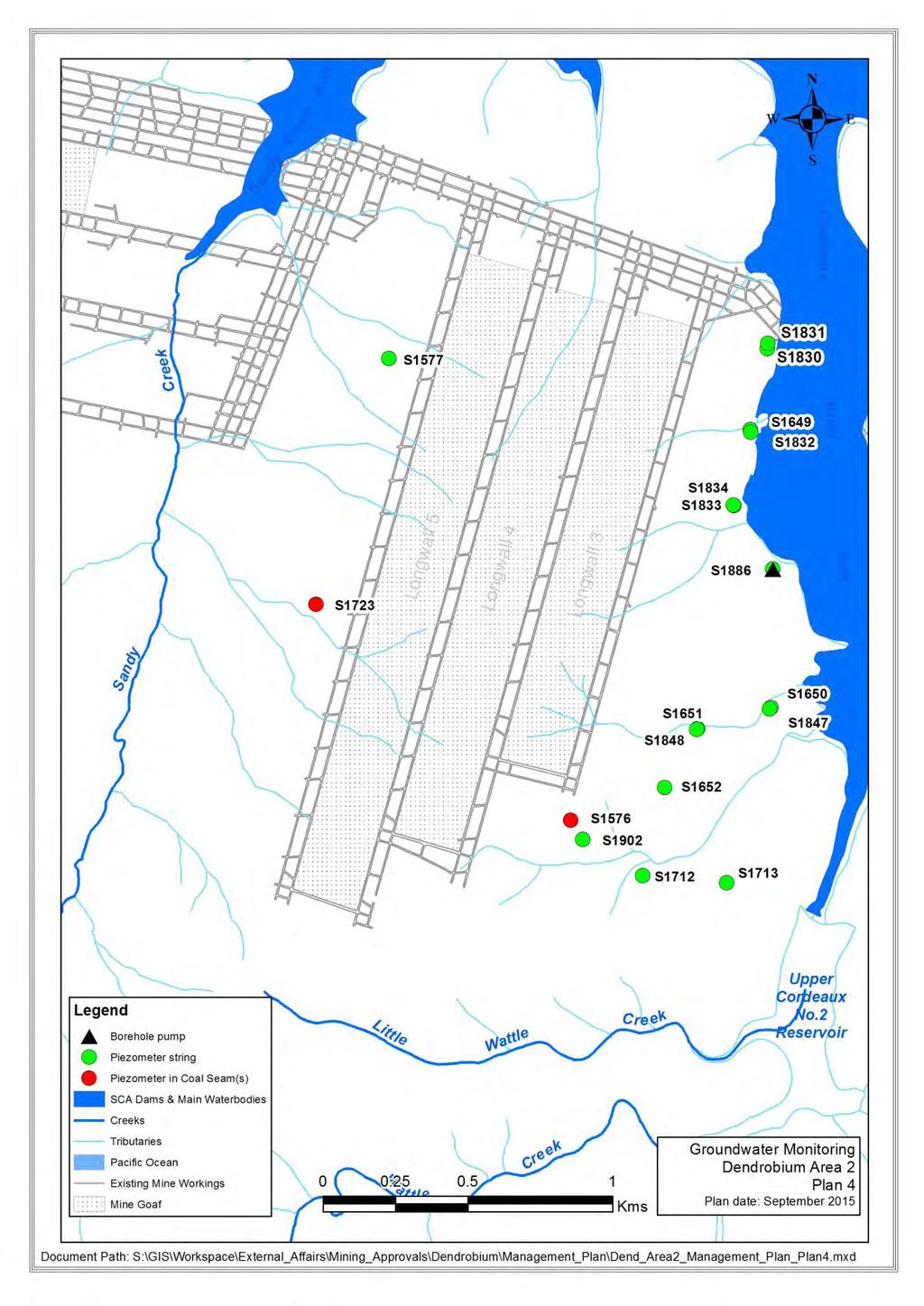
20 7.4.4 Environmental Monitoring at the Mining Face Under the requirements of the Work Health and Safety (Mines) Act 2013 (NSW) and associated Regulations, Mine Statutory Personnel conduct regular inspections of all areas of the mine. These inspections include reporting of roadway conditions with respect to the stability of mine roadways. Section IV of Annexure D requires information from these inspections to be provided to the DSC as detailed in the table below. This information relates to conditions which could influence the magnitude of surface subsidence, performance of pillars, or permeability of the strata. Specific inspections and responses are also required under the Inrush Management Plan (IMP) and the TARP included in the IMP. DSC Condition Reference Actions to Demonstrate Compliance Responsibility Inspection of Workings Annexure D, Section IV Weekly visual inspections of the workings whenever mining in the Notification Area (or within 6 months of cessation of mining) Monthly geotechnical report of results to DSC including : - Pillar performance (spalling, deterioration) - Roof conditions (guttering, falls, pillar punching, degree of caving etc) - Floor conditions (floor heave or pillar punching) - Water inflows - Plan showing extraction/development for the period (coloured) Geotechnical Engineer and Underground Mining Officials Groundwater Monitoring Groundwater monitoring is a Secondary Monitoring Control undertaken to determine and assess hydrogeological conditions within the rock mass between the Reservoirs and the Wongawilli Seam in Areas 1, 2, 3A and 3B. This monitoring aims to detect the impacts of mining on groundwater, assess groundwater flow from stored water and provide verification of the results of hydrological modelling. The monitoring consists of measuring and recording pressures from piezometers to allow for estimation of a flow direction and quantity through the rock mass (i.e. from the stored water in the reservoir to the longwall extraction). These determinations are one of the inputs used for the analysis of the source of groundwater reporting to the mine workings. Groundwater monitoring at Dendrobium consists of both shallow and deep monitoring. The shallow groundwater monitoring is primarily used to assess impacts on surface flows, swamps Page 20 of 72
21 and ecology, the deep groundwater monitoring is used to understand inflows into the mine. In Areas 1 and 2 deep groundwater monitoring was heavily focused on the area between the extraction and the Reservoir. The monitoring in Area 3 has been designed to provide regional groundwater data in addition to increased monitoring near the reservoir where access is available. Groundwater Monitoring details are shown in Plans 3 5. DSC Condition Reference Actions to Demonstrate Compliance Responsibility Monitoring of groundwater pressures Annexure D1, Section II Monitoring as per the Monitoring Plan Monthly report to DSC with analysis and interpretation of the monitoring results: - Piezometric data from each hole in terms of pressure and equivalent height in metres above AHD - Graphs to demonstrate piezometric trends over time - Indication of longwall or other mining activities Planning Manager/Water Balance Officer Subsidence Monitoring Due to terrain, vegetation and access restrictions, the primary method of monitoring subsidence movements over Dendrobium Areas 1, 2, 3A and 3B is via Airborne Laser Scanning (ALS). This technique generates a complete topographic model of the subsidence. The initial base survey for Area 3B was captured in 2005 and was captured again in January 2013 immediately prior to the commencement of longwall operations in Area 3B. ALS surveys are conducted prior to any mining, after the completion of each longwall and 12 months after the completion of longwall extraction in each mining area. Contours of subsidence from each longwall will be provided to the DSC. Subsidence monitoring for Area 3B is shown in Plan 7 (SDS2021). Selected 3D survey marks are established and monitored to augment the ALS data. The points are established in accessible areas as control reference points for the ALS and to provide information on horizontal ground movements. The 3D survey points are distributed throughout Area 3B, however the locations are subject to site constraints i.e. at locations with good sky windows suitable for high resolution GPS surveying. The survey frequency of these points will coincide with ALS data capture. Additional subsidence monitoring sites will be installed to measure closure across the Native Dog Creek arm of Lake Avon prior to the extraction of Longwall 12. Page 21 of 72
22 The DSC agreed to the cessation of monitoring of Areas 1 and 2 3D points. Visual monitoring (for cracking) is undertaken and reported with each set of subsidence data. Visual inspection of the active subsidence area is undertaken in accordance with the SMP. DSC Condition Reference Actions to Demonstrate Compliance Responsibility Subsidence and Strain Monitoring Annexure D, Section IX (only applicable to Area 3A. Condition doesn t apply to LW11 approval) Remote scanning of Digital Terrain Model by ALS after mining each longwall block and 12 months after completion of mining in Area 3A 3D subsidence monitoring stations as a control for the DTM after mining each longwall block and 12 months after completion of mining in Area 3A Survey results to DSC within 1 week of survey (except ALS 2 months after analysis) Pursuant to Annexure D, Section XII monitoring is to continue until the DSC considers that is longer required. Survey Manager Page 22 of 72
23 Page 23 of 72
24 Page 24 o

25 Page 25 of 72

26 Plan 6 Page 26 of 72
27 7.4.7 Statistical Reports The amount of coal extracted and any other statistics related to the approval are reported to the DSC at intervals as specified in Annexure D. DSC Condition Reference Actions to Demonstrate Compliance Responsibility Total tonnage extracted and other statistics related to the approval Annexure D, Section XIX Written report of total tonnage extracted and other statistics related to the approval on an annual basis for each year ending June 30th to be supplied by July 31st each year Progressively reported in the monthly report Planning Manager Compliance Reports Dendrobium monitors and reports compliance with approval conditions in a statement of compliance at intervals as specified in Annexure D. DSC Condition Reference Actions to Demonstrate Compliance Responsibility Statement of compliance with all monitoring conditions Annexure D, Section XX Monthly written statement of compliance with all monitoring conditions in the Monthly Report Planning Manager/Water Balance Officer Monitoring, Reporting and Extraction Schedule An updated Monitoring, Reporting and Extraction Schedule is submitted at intervals as specified in Annexure D. The schedule will track future mine workings, status of reports required by the DSC, and requirements for implementing certain monitoring and other conditions (e.g. required dates for installing equipment). DSC Condition Reference Actions to Demonstrate Compliance Responsibility Regularly updated schedule which tracks future mine workings, reports to be submitted to the DSC and requirements for implementing certain monitoring or other conditions Liaison Officer Annexure D, Section XXI (Condition doesn t apply to LW11 approval) Monthly Monitoring, Reporting and Extraction Schedule to be submitted to DSC including target dates for starting and finishing each block, or other mining area as determined by the DSC included in the Monthly Report Planning Manager Dendrobium has appointed the Manager Approvals as a suitably qualified and experienced person, acceptable to the Committee, as a liaison officer for the period where there is active mining in any Notification Area and for an additional period afterwards as determined by the Committee. Page 27 of 72
28 DSC Condition Reference Actions to Demonstrate Compliance Responsibility Appointment of Liaison Officer Annexure D, Section XXII Dendrobium employee appointed to act as Liaison Officer to ensure effective coordination and management of the monitoring programs Planning Manager Face Location A plan is provided to the DSC showing the location of any active faces, to the satisfaction of the Committee, at intervals as specified in Annexure D. DSC Condition Reference Actions to Demonstrate Compliance Responsibility Plan showing location of any active faces Annexure D, Section XXIII Plan ed to the DSC each week showing the location of active faces Mine Surveyor Dendrobium Dyke Monitoring In September 2013 DSC approved the monitoring regime for West Mains 4 cut-through to return to normal levels of monitoring. Page 28 of 72
29 8 CONTINGENCY PLAN This Plan describes the contingency requirements for the Cordeaux and Avon Reservoirs DSC Notification Areas, which has been developed in accordance with the relevant provisions of the Dams Safety Act 1978, to minimise the loss of stored water from the reservoir as a result of mining within the Notification Areas. 8.1 SCOPE This Plan applies to all development and longwall extraction i.e. first and second workings within the DSC Cordeaux and Avon Dams Notification Areas and other areas and operations at Dendrobium Mine (existing and proposed Dendrobium Mine - Plan 1). This Plan identifies potential risk of extraneous inflow of water sources from the Reservoirs and potential failure mechanisms, which may lead to an unexpected condition. In accordance with Annexure D Condition 16.1, the Plan describes the emergency plan of action designed to contend with an inrush of stored water to minimise water loss from the storage. This Plan: References the monitoring activities to identify loss of stored water from the Reservoirs to the mine workings; Details the trigger levels related to each form of monitoring (where appropriate) and defines the actions to be taken as a trigger level is reached, including reporting requirements; and Details the personnel responsible for taking each action (including notification of relevant personnel and stakeholders) and the resources that are available for each response. Specifically listed DSC 4D Contingency Requirements covered by the Plan are: Capacity of the pumping system; Capacity of the underground storage facilities; Design of the bulkheads; The name, position and role of key personnel; A contact telephone list; and Grouting procedures and the applicability of these procedures to likely inflow mechanisms. In addition the Plan: Outlines the processes to monitor and identify any extraneous inflow of water; Provides for the assessment of the causes of any such flows; and Clearly defines the necessary trigger levels and response actions. Page 29 of 72
30 8.2 CONTROL PROCEDURES This Plan provides a framework to encompass the emergency procedures and reporting requirements recommended by the DSC as per DSC 4D (formally DSC 35). In the case of Areas 1, 2, 3A and 3B, this refers to DSC Section XVI Contingency Plans Annexure D Condition This includes the following requirements: Monitoring those Principal and Secondary Monitoring Controls that monitor the surface and underground environment to detect any abnormal inflow. Pumping - that provides time for assessment to be conducted and/or the appropriate response to be initiated without adverse effect on mining operations. Remedial - those designed to correct an unacceptable inflow from any source but most specifically from the Reservoirs Principal Monitoring Controls The primary elements of the Principal Monitoring Control are used to quantify total inflows and outflows in relation to defined mining areas and the total water imbalance. This includes the following requirements: Underground Water Sampling and Analysis refer Section Underground water analysis sampling locations and zones are detailed on plan DEN (Plan 7). Underground Water Balance refer Section Secondary Monitoring Controls Secondary Monitoring Controls result in triggers that alert mine management to the potential for an abnormal inflow and that initiate low level alarms within the Principal Monitoring TARP. In Seam Drilling refer Section Monitoring of Workings refer Section Ground Water Monitoring refer Section Subsidence Monitoring refer Section PUMPING Pumping is a fundamental control procedure relating to the management of water and is treated within the IMP. The Mine operates a comprehensive pumping system to provide for regular dewatering of the underground workings. Mine water management is detailed in drawing DEN-07- Page 30 of 72
31 3322 and Schematic drawing DEN (Plan 8 and 9). Total designed pump out capacity is 155 litres per second. Large and unexpected flows of water into the mine workings will be dealt with in the first instance by air operated pumps installed in the vicinity of the working panels and lowest points in the perimeter roads around goaf areas. Should inflows exceed the capacity of installed pumps, additional pumps will be sourced and this will represent a trigger initiating action within the Principal Monitoring TARP. The Mine Water Balance Procedure is the standard for monitoring the water flow in and out of the mine. The water balance is utilised as a means of quantifying abnormal inflows to various parts of the mine. Monitoring of the inflow and outflow to Areas 1, 2, 3A and 3B occurs through the daily water balance. Page 31 of 72

32 Page 32 of 72
33 PLAN 9 Page 33 of 72
34 8.4 CONTINGENCY ACTIONS Grouting, PUR Injection and Similar Activities The fundamental remedial strategy for addressing abnormal water inflows from conduits such as fissures through the strata, associated with disturbances such as faults or dykes, or from diffuse sources such as porous ground or horizontal shear, regardless of source, may take the form of one of a number of established engineered solutions for stopping or controlling water flows through strata. The application of a particular consolidation technique to any circumstance of abnormal water inflow to the mine from (or potentially from) the Cordeaux or Avon Reservoirs will be determined at the time by the decision of all stakeholders (Illawarra Coal, DSC and Water NSW) based on the advice of ground consolidation experts. The Review Team will take appropriate early remedial action to avoid the need to elevate the defined response to a Principal Monitoring trigger. Types of remedial actions available for gaining control of water inflows to the mine and their applications are summarised below. Description of Flow Mechanism Remedial Action Injection Location Disturbed or fractured ground Concrete blinding Surface/ underground Regional water flows through porous/ fractured strata Localised sealing of open fractures and joints Installation of grout curtains (cement based or chemical compounds) Polyurethane resin (PUR) injection or cement based grouts Surface/ underground Surface/ underground Sealing The installation of ventilation seals to isolate the Area 1 goaf was undertaken as Longwalls 1 and 2 were extracted. Each cut-through in Tailgate 1 and Maingate 2 was sealed for mine ventilation purposes. Subsequently Area 1 was sealed from the mine ventilation system leaving only one heading in Tailgate 1 open as an intake roadway. Several of these ventilation seals contain monitoring, sampling facilities. Ventilation seals have progressively been installed as longwalls are extracted. The final sealing of the mine requires hydraulic seals to be installed that ensure any stored water from the reservoir reporting to the mine is controlled. The overall sealing strategy for mine water is contained in the Closure Plan (Section 9). Page 34 of 72
35 In the event stored water inflows approach DSC permissible limits, triggers will initiate a number of actions. The decision to abandon contingent techniques designed to maintain control of these inflows and commence the installation of hydraulic seals either to isolate particular areas or to seal the mine are defined in Trigger Action Response Plans. Otherwise the sealing strategy for the Mine is described in the Closure Plan. A specific hydraulic seal has been designed for the mine. It consists of a two stage concrete sleeve/plug and associated grouting. The SMEC design is documented in the report Dendrobium Water Inflow Solution Concrete Sleeve/Plug Design Report, December TRIGGER ACTION RESPONSE PLANS The Principal Monitoring TARP relates to identifying, assessing and responding to abnormal water inflows into the mine. The Principal TARP represents actions to be taken as each trigger level is reached. On the basis of water balance and analyses the following will occur: Should stored water be identified in water ingress to the mine, the rate of stored water inflow would be used to estimate the quantity of stored water inflows for the complete longwall, based on the data available at that time. The Review Team will take appropriate remedial action whenever the projected total stored water inflow reaches a trigger level. Known water inputs to Areas 1, 2, 3A, 3B and the total discharge from these areas are continuously tracked on the Mine s SCADA. The trigger levels, to initiate remedial action, are based on the total Areas 1, 2, 3A and 3B balance and analysis. The trigger levels specifically exclude Area 2 rainfall related inflows. Normal water inflow conditions will be defined as being < 0.5ML/day of stored water inflow to the mine from each of the stored waters (Cordeaux and Avon) averaged over a seven day period. All stored water inflow levels referenced within TARPs are based on this same standard of being averaged over seven days. The Principal Response Flowcharts (Figure 2) describes the process of decision making to be applied with respect to taking corrective actions in this Plan. Separate TARPs are provided for Cordeaux (Figure 2a) and Avon (Figure 2b) storages. The following changes are proposed to the Principal and Secondary TARPs: It is critical that Dendrobium Mine is able to detect early presence of stored water and deal with the source and treatment deliberately in the TARPs. A second TARP has been incorporated into the Plan to cater for stored water from Lake Avon (Figure 2b). Page 35 of 72
36 The groundwater models predict increased water make as new domains are extracted, the overall water in-balance is expected to increase (Figure 11, Hydrosimulations March 2014). It is proposed that the trigger levels based on total mine water imbalance (not stored water) should be increased to reflect the increased water make into the mine as additional mining areas are developed. The DSC is yet to agree to this principle. As this is a total mine water balance it is applied to both the Cordeaux and Avon TARPs. Page 36 of 72
37 8.6 PRINCIPAL TARP FLOW CHART Figure 2a Principal Response Flowchart - Cordeaux All flow rates averaged over 7 day period Underground Water Balance Recorded in Real Time (collected in SCADA) Underground Water Sampling and Analysis Updated manually as received Note: Water Balance volumes exclude Area 2 rainfall related inflows. Actions in blue Italic are only for Stored Water Daily Data Input and Review 0.5 ML/day stored water and/or 9ML/day total mine water imbalance >0.5ML to 1ML/day stored water and/or >9ML/day to 11ML/day total mine water imbalance >1 ML/day to 1.9ML/day stored water and/or >11ML/day to 13ML/day total mine water imbalance >13ML/day total mine water imbalance > 1.9ML/day stored water (Cordeaux) Normal Level 1 Alarm Level 2 Alarm Level 3 Unacceptable Stored Water Normal responsibilities apply Planning Manager responsible for action Planning Manager responsible for action General Manager responsible for action General Manager responsible for action No remedial action necessarry Advise DSC and Water NSW. Review all other monitoring inputs for anomalies, likely sources and 'conduit' path. Assess the need for increased sampling frequency and/or pumping capacity. Assess the need to seek expert advice re appropriate remedial solution or other water reduction strategy Advise DSC and Water NSW. Review requirement for increased sampling and reporting frequency. Consider Incident Management Team activation. Review pumping and production strategy as necessary. Formulate and implement a water reduction strategy. Seek expert advice re appropriate remedial solution or other water reduction strategy. Advise DSC and Water NSW. Review Level 2 sampling and reporting frequency. Activate Incident Management Team Modify production and pumping strategy to suit. Advise DSC and Water NSW. Activate Incident Management Team Stop Longwall And Development operations Adopt contingency measures from Level 2 Execute mitigation and sealing strategies Monthly review meeting Monthly review meeting Increase review meeting frequency to fortnightly IMT meetings daily & review meetings weekly seek DSC input IMT and review meetings daily Page 37 of 72
38 All flow rates averaged over 7 day period Underground Water Balance Recorded in Real Time (collected in SCADA) Figure 2b Principal Response Flowchart - Avon Underground Water Sampling and Analysis Updated manually as received Note: Water Balance volumes exclude Area 2 rainfall related inflows. Actions in blue Italic are only for Stored Water Daily Data Input and Review 0.5 ML/day stored water and/or 9ML/day total mine water imbalance >0.5ML to 1ML/day stored water and/or >9ML/day to 11ML/day total mine water imbalance >1 ML/day to 1.9ML/day stored water and/or >11ML/day to 13ML/day total mine water imbalance >13ML/day total mine water imbalance > 1.9ML/day stored water (Avon) Normal Level 1 Alarm Level 2 Alarm Level 3 Unacceptable Stored Water Normal responsibilities apply Planning Manager responsible for action Planning Manager responsible for action General Manager responsible for action General Manager responsible for action No remedial action necessarry Advise DSC and Water NSW. Review all other monitoring inputs for anomalies, likely sources and 'conduit' path. Assess the need for increased sampling frequency and/or pumping capacity. Assess the need to seek expert advice re appropriate remedial solution or other water reduction strategy Advise DSC and Water NSW. Review requirement for increased sampling and reporting frequency. Consider Incident Management Team activation Apply pumping strategy as necessary Review Production Strategy Formulate and implement a water reduction strategy. Seek expert advice re appropriate remedial solution or other water reduction strategy. Advise DSC and Water NSW. Review Level 2 sampling and reporting frequency. Activate Incident Management Team Modify production and pumping strategy to suit. Advise DSC and Water NSW. Activate Incident Management Team Stop Longwall And Development operations Adopt contingency measures from Level 2 Execute mitigation and sealing strategies Monthly review meeting Monthly review meeting Increase review meeting frequency to fortnightly IMT meetings daily & review meetings weekly seek DSC input IMT and review meetings daily Page 38 of 72
39 8.7 PRINCIPAL TARP At 1ML/day of stored water from Cordeaux or Avon the General Manager will stop Longwall and Development operations following confirmation of this level. When remedial measures bring stored water inflows back below this level, Longwall and/or Development operations may resume. If unable to stem flows using other remedial measures, the General Manager will implement recovery of the Longwall and Development district and sealing of the areas according to the Mine Closure Flow rates averaged over 7 day period CHARACTERISTICS OF LEVEL Total Underground Water Balance Coupled with Sampling and Analysis POSSIBLE REASONS ACTIONS ACTION BY NOTIFICATION NORMAL 0.5 ML/day stored water and 9ML/day total water imbalance N/A No remedial action necessary Monthly review meeting No Special Action Required None necessary Level 1 > 0.5 to 1.0 ML/day stored water or >9 to 11ML total water imbalance and/or Unacceptable secondary monitoring alarm Intersection of conduit to stored water source Increased groundwater make Normal No.3 seam water make Advise DSC and Water NSW. Review all other monitoring inputs for anomalies, likely sources and 'conduit' path. Assess the need for increased sampling frequency and/or pumping capacity. Assess the need to seek expert advice re appropriate remedial solution or other water reduction strategy Planning Manager Water Balance Review Team DSC and Water NSW (notification within 24 hours of confirmation) Level 2 >1.0 to 1.9ML stored water or >11 to 13 ML/day total water imbalance Intersection of conduit to stored water source Increased groundwater make Advise DSC and Water NSW. Review requirement for increased sampling and reporting frequency. Consider Incident Management Team activation. Review pumping and production strategy as necessary. Formulate and implement a water reduction strategy. Seek expert advice re appropriate remedial solution or other water reduction strategy. Planning Manager Water Balance Review Team DSC and Water NSW (immediately on confirmation) Level 3 Unacceptable Stored Water >13ML/day total water imbalance >1.9ML/day stored water Increased groundwater make Intersection of conduit to stored water source Note: Water Balance Volumes exclude Area 2 Rainfall related events Advise DSC and Water NSW. Review Level 2 sampling and reporting frequency. Activate Incident Management Team Modify production and pumping strategy to suit. Advise DSC and Water NSW. Activate IMT Stop Longwall and Development production Adopt contingency measures from Level 2 Mobilise mitigation and sealing strategies IMT and review team meetings daily seek DSC input General Manager General Manager Water Balance Review Team IMT DSC and Water NSW (immediately on confirmation) Water Balance Review Team IMT DSC and Water NSW (immediately on confirmation) Actions in Blue Italic are only for Stored Water Page 39 of 72
40 8.8 SECONDARY TARP TARP1 District Underground Water Balance Annexure D Conditions 7.1, 8.1, 8.2, 8.3 Level 1 Secondary Monitoring Alarm Level 2 Secondary Monitoring Alarm Level 3 Secondary Monitoring Alarm TARP2 Monitoring of Workings Annexure D Condition 4.1 Planning Manager Planning Manager Planning Manager TARP3 In-seam Drilling Appendix D1 Conditions 2.1, 2.2, 2.3 TARP 4 Area 3A Ground Water Monitoring Annexure D Conditions 7.1, 8.1, 8.2, 8.3 Inspection of workings in greater detail. Check all other monitoring points Inspection of workings in greater detail. Check all other monitoring points Review Team to consider implementation of Primary Level 1 Actions Activates Level 1 Principal Monitoring Alarm Figure 3 - Represents the relationship between the Secondary Monitoring TARPs and the Principal Monitoring TARP Page 40 of 72
41 Secondary TARP 1 - District Underground Water Balances Coupled with Sampling and Analysis CHARACTERISTICS OF LEVEL POSSIBLE REASONS ACTIONS ACTION BY NOTIFICATION NORMAL Proportion of stored water < 20% of district discharge N/A None necessary. Continue normal district monitoring, sampling and analyses: In Longwall - Weekly in active zone and monthly in nonactive zones No Special Action Required None necessary Level 1 Proportion of stored water as a proportion of development panel district discharge 20% (potentially only small quantities) Intersection of conduit to stored water source Inspection of all possible inflow zones in district Review all other monitoring inputs for anomalies Activate additional pumping capacity as necessary Initiate site remedial actions as necessary Planning Manager Review Team Level 2 Proportion of stored water >20% to 50% of district discharge in Longwall Panel (potentially larger quantities involved) Intersection of conduit to stored water source Intersection of goaf breaks with aquifer etc Increase frequency of all district sampling and analysis to weekly. Check SCADA data and assess need to activate any alarm levels Initiate site remedial actions as necessary Activate additional pumping capacity as required Planning Manager Review Team Level 3 Proportion of stored water >50% of district discharge Intersection of conduit to stored water source Intersection of goaf breaks with aquifer etc Activate level 1 Principal Monitoring Alarm Planning Manager Review Team DSC and Water NSW Page 41 of 72
42 Secondary TARP 2 Monitoring of Workings CHARACTERISTICS OF LEVEL POSSIBLE REASONS ACTIONS & CONSIDERATIONS ACTION BY NOTIFICATION Normal Some water make from roof, floor and sides. Minor water flow from drill holes. Minor geological structures exist with little or no water. Generally good roof and sides N/A None necessary. Continue normal district inspections and observations No Special Action Required None necessary Level 1 Level 2 Level 3 Water make from roof, floor and sides increases. Increase in water surrounding mining equipment (set up of face pumps). Regular flow of water from drill holes. Increase in water around any geological structure. Roof and ribs degenerating as a result of water make. Abnormal water flow from strata, particularly if causing failing strata conditions (operations affected). Continual flow of water from drill holes. Intersection of a significant structure e.g. Fault with throw >1m or large quantity of water flowing from any structure, major roof failure that does not reduce over time Continuation of abnormal water flows causing strata deterioration. Inflow of water from stored waters. Intersection of a major structure e.g. Fault with throw >2m. Intersection of conduit to stored water source Increased groundwater make due to rainfall, intersection of goaf breaks with aquifer etc Normal No.3 Seam water make. Intersection of conduit to stored water source Increased groundwater make due to rainfall, intersection of goaf breaks with aquifer etc Intersection of conduit to stored water source Increased groundwater make due to rainfall, intersection of goaf breaks with aquifer etc Inspection of all possible inflow zones in district Review all other monitoring inputs for anomalies Activate additional pumping capacity as required Increase district sampling and analysis frequency to weekly. Check SCADA data and assess need to activate any alarm levels. Activate Level 1 Principal Monitoring Alarm Planning Manager Planning Manager Planning Manager Review Team Review Team Review Team, DSC and Water NSW Page 42 of 72
43 Secondary TARP 3 In-Seam Drilling CHARACTERISTICS OF LEVEL POSSIBLE REASONS ACTIONS & CONSIDERATIONS ACTION BY NOTIFICATION Normal Drilling confirms known/projected structures ahead of development. No water flow from intersected structures N/A Drilling maintained between workings and reservoirs No Special Action Required None necessary Level 1 Unpredicted structure of minor magnitude e.g. fault with throw 0 to 1m with signs of dampness Structure of significant magnitude e.g. fault with throw >1m but with no associated dampness means <300L/hr water flow from hole Structure of limited extent or emergence of previously unknown structure Execute provisions of the Strata Failure Management Plan Inspect structure when exposed, map and assess its potential to act as a water conduit in future workings Planning Manager Review Team Level 2 Level 3 Unpredicted structure of minor magnitude e.g. fault with throw >1m and 2m with signs of dampness Structure of significant magnitude e.g. fault with throw >2m but with no associated dampness. Unpredicted structure of major magnitude e.g. fault with throw < 2m with signs of moderate water flow (Moderate water flow >300 and <1500L/hr) Any structure generating significant water flow from the hole (significant water flow > 1500L/hr) Structure of limited extent or emergence of previously unknown structure. Structure connected to stored water, to inseam water accumulation or to another conduit to stored water or in seam water accumulation Structure of limited extent or emergence of previously unknown structure. Structure connected to stored water, to inseam water accumulation or to another conduit to stored water or in seam water accumulation Execute provisions of the Strata Failure Management Plan Inspect and assess potential for water inflow problems during Longwall or Development mining. Include in description of geological structure in monthly report Activate level 1 principal monitoring alarm Planning Manager Planning Manager Review Team Review Team, DSC and Water NSW Page 43 of 72
44 Secondary TARP 4 Area 3A Ground Water Monitoring (Bores S1867, 1870, 1992 & 1994) CHARACTERISTICS OF LEVEL POSSIBLE REASONS ACTIONS ACTION BY NOTIFICATION Normal Depressurisation of Scarborough Sandstone to Wongawilli Seam strata Partial depressurisation of Hawkesbury & Bulgo Sandstones Predicted impact of Longwall on Groundwater Download Area 3 piezometers monthly Review data at normal review team meetings Planning Manager None necessary Level 1 Piezometric Head in the Bulgo Sandstone approaches SWL Water movement commencing towards goaf Review Team to consider data and review water balance and other monitoring data and determine appropriate actions Planning Manager Review Team Level 2 Piezometric Head measured in one Bulgo Piezometer (within a borehole) drops below Cordeaux Dam SWL Water movement commencing towards goaf Review Team as per Level 1 Increase download frequency of remaining piezometers to weekly Planning Manager Review Team Level 3 Piezometric Head measured in all Bulgo Piezometers (within a borehole) drops below Cordeaux Dam SWL Water movement towards goaf Actions in Level 2 Activate Level 1 Principal Monitoring Alarm Planning Manager Review Team, DSC and Water NSW Page 44 of 72
45 9 CLOSURE PLAN The Plan is a requirement of DSC Standard Condition Annexure D, Section XVIII Closure Plans of existing approvals. There are no Avon Reservoir Notification Area approvals that specify closure requirements. The Plan describes the appropriate sealing protocols for the mine: At the completion of operations, or An inrush of stored water from the Reservoirs, being a failure of the IMP provisions, or Failure to control inflows from a Reservoir within DSC acceptable limits, being a failure of the Plan contingency provisions. 9.1 SCOPE This Plan applies to: The closure of Dendrobium Mine at the completion of the operations or as required to effectively control adverse water inflow. Sealing methods for the underground areas of the mine and the mine entries to fulfil the obligations imposed by the DSC Notification Area Approvals, consistent with the requirements of the NSW Coal Mining Health and Safety Act 2002 and NSW Coal Mining Health and Safety Regulations 2006 and Dendrobium Lease Conditions. 9.2 ASSUMPTIONS The assumptions upon which this Plan is based are: Total stored water inflows from Cordeaux Reservoir into Dendrobium are limited to a maximum of 1 ML/day during the life of the mine, while the short-term mine limit of 2 ML/day can be achieved without the use of remedial measures. A sustained loss of no more than 1ML per day be applied to future mining operations within the Avon Notification Area; Permanent hydraulic seals can control long-term stored water inflows to Areas 2 and 3 to zero so that residual inflows into Area 1 represent the long term losses from Cordeaux Reservoir and are maintained below 1 ML/day. The final seals erected to seal Area 1 and the Mine portals limit any flow of stored water from the mine entering via the Wongawilli Seam workings to less than 1 ML/day regardless of the failure of the inbye seals. The final seals to Area 1 do not address potential leakage from the reservoir via the Mt Kembla Mine Bulli Seam workings to the Area 1 goaf. Any stored water Page 45 of 72

 Final Closure Plan Formalised (DSC, Water NSW & T&I consultation) Mine Closure Initiated (DSC, Water NSW & T&I consultation)")
46 inflow to the Area 1 goaf via the Mt Kembla workings would be dealt with by the Contingency Plan (Section 8) prior to implementing the Closure Plan. The final design of the permanent hydraulic seals with regard to leaky versus non-leaky will be assessed as part of mine closure. Hydraulic seals erected must have 100+ years life. 9.3 CONTROL PROCEDURES The process that will govern the installation of permanent hydraulic seals (in consultation with the DSC, Water NSW and DTI) is: Site Investigation. Detailed Design of Permanent Seals (DSC, Water NSW & T&I consultation) Final Closure Plan Formalised (DSC, Water NSW & T&I consultation) Mine Closure Initiated (DSC, Water NSW & T&I consultation) Review Team (DSC, Water NSW & T&I Consider Issues with Closure - Risk Assement Conducted Prepare Sites & Build Seals Figure 4 - Process of installation of Permanent Seals Water Inflow Scenario Analysis A scenario analysis has been undertaken as the basis for developing/reviewing the mine closure sealing strategy. Table 1 summarises water inflow scenarios, potential leakage paths expected, flow/flooding sequences and experiences to date. Potential Leakage Paths Wongawilli Seam Dendrobium Portals Scenario Analysis Any water accumulation in the workings would be subjected to the normal hydrological regime that draws water down dip to the northwest. Area 3 is down dip of Area 2 which is down dip of Area 1. Any significant flow of water would result in ponding in the workings. Depending on the source, if the Contingency Plans or the IMP were not successful, the flow would result in flooding of the workings. The highest point in the mine is Nebo Mains 1 cut-through, adjacent to Dendrobium and Kemira Valley Tunnels. Ultimately the water level would rise and over flow would occur to the Kemira Valley portal, due to the level in Dendrobium Tunnel. Connections to Adjacent Wongawilli Seam Workings Page 46 of 72
47 Potential Leakage Paths Connecting Headings In-seam Boreholes Seepage Shafts Exploration Boreholes Vertical and Inclined Boreholes Scenario Analysis There are no planned connections to the adjacent Kemira or Nebo Workings and the IMP requires a system of protective boreholes to ensure that workings do not inadvertently mine into an unmarked roadway. There are no adjacent workings within 500m of the proposed Area 2 or 3 workings. These have been used to prove the location of adjacent workings and manage water accumulations. Currently there are live boreholes being used to emplace and drain the water from Kemira Colliery. In addition there are boreholes to Nebo Colliery (now part of the adjacent Wollongong Coal s Wongawilli Colliery) to emplace mine water and draw off clean water. The holes are nominally 100mm diameter. All holes have been surveyed and are included in the Dendrobium Mine Plan. Dendrobium has already worked down dip of accumulated water in the adjacent Kemira and Nebo Workings. Nebo Mains at the closest point is 45 metres from Nebo Workings where the head is approximately 15 metres above Nebo Mains. Kemira Mains, at the closest point, is 127 metres from Kemira Mine Workings, which have 27metres head of water at that location. Dendrobium workings do not have a noticeable water make from these adjacent flooded workings. There is no measurable seepage from neighbouring Wongawilli Seam workings but any water that does result from long term seepage from adjacent workings can be clearly and scientifically differentiated from water entering the mine from Cordeaux Reservoir. Connections to Overlying Bulli Seam Mount Kembla Workings Dendrobium No 1 Shaft was sunk through the overlying Bulli Seam Workings to the Wongawilli Seam. There are no identified shafts or drifts from the Mt Kembla Workings to the Wongawilli Seam workings. All exploration borehole locations are known and proper abandonment protocols will continue to be carried out. Currently there are no significant flows from the Mount Kembla Workings. The holes are drilled to ensure that all overlying water is drained prior to development and extraction beneath the potentially flooded workings. The holes are nominally 100mm diameter. All holes have been surveyed and are included on the Dendrobium Mine Plan. Standpipes and gate valves control any flows from these holes during their operating life. Each borehole not destroyed as a result of the formation of a longwall goaf will be backfilled with cement at the end of its operating life. Connection through Goaf Fracturing The comprehensive drilling programme to drain the overlying Mt Kembla Workings in the Bulli Seam prior to longwall extraction in Area 1 has not identified significant standing water. Uphole drilling and the subsequent extraction of Longwalls 1 and 2 has effectively drained the overlying Mt Kembla workings. The water make from the Area 1 goaf is currently less than 0.5 ML/day; water testing indicated that none of this is sourced from the Cordeaux Reservoir. The sealing of the Dendrobium workings inbye of the overlying Mt Kembla workings would ensure that, in the long term, water did not find its way into the Longwall 1 and 2 goafs and potentially to the Mount Kembla Portals from Areas 2 and 3. Bulkheads are planned to be established at Site 1 in Nebo Mains between 30 and 31 cut-throughs to stop water from entering Area 1. The review of the sealing strategy in October 2009 (see section 4.3) confirmed this strategy. The potential connection between the reservoir and the Area 1 goaf (and the overlying Bulli Page 47 of 72
48 Potential Leakage Paths Scenario Analysis Seam Workings) is proposed to be managed as part of the Contingency Plan in the short term and as part of the Closure Plan in the long term. A grout curtain erected from Nebo Mains or Tailgate 1 is expected to be effective in controlling the flow into the Longwall 1 goaf. Any leakage from the reservoir into the Mt Kembla Bulli Seam Workings (directly or through the Area 1 goaf) not successfully managed by the installation of an underground grout curtain during the life of the mine, or after the mine was closed, then the installation of a grout curtain from the surface or a clay liner to a section of the Kembla Creek Arm of the dam would be considered. Sealing strategies close to the source of the water are preferred to strategies at the outflow. The sites of the Mt Kembla portals, which are the potential outflow points, has been reviewed and it is expected that sealing multiple sites along the escarpment to withstand the hydraulic head would be extremely difficult given the issue of limited overburden and ground stability. A flow into the Bulli Seam workings would report to the low point over Longwall 1 and 2 and accumulate behind the goaf seals. Monitoring of the water level and composition is planned through-out the life of the mine. It is highly unlikely that such a flow would not be identified during mine life. Post closure the installation of a grout curtain and clay liners are proven technologies and early indications of the effectiveness could be gauged by the installation and monitoring of piezometers. Table 1 Water Inflow Scenarios 9.4 HYDRAULIC SEAL DESIGN GHD (February 2005) have provided a conceptual permanent bulkhead design that can satisfy the recommendation of the Forbes Rigby, now Cardno, Consequence Study (2005), which determined the conceptual design of permanent water retention bulkheads as final seals in the event of uncontrollable inrush, stored water inflow or as a part of the normal mine closure protocol. Two sites are identified for final seal location according to the strategy defined in Section 9.5 and Plan 10 shows the location of the permanent seal sites. The seals relevant to the Closure Plan are the hydraulic seals or permanent water retention bulkheads. Detailed seal designs for each site will be developed in consultation with the DSC and Water NSW. 9.5 SEALING STRATEGY Given the likely flow paths for water into the mine and the likely outflow connections to the surface, the following points are noted to ensure that sealing solutions provided by Dendrobium Mine meet both the short and long term limits on stored water outflow from the Mine. Inflows to the mine will be monitored during the extraction of longwalls. The Contingency Plan details the actions that will be taken if monitoring indicates projected stored water inflows will exceed DSC limits. Page 48 of 72

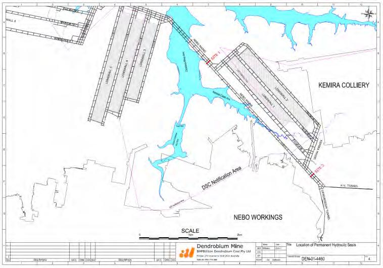
49 PLAN 10 Page 49 of 72
Subsidence Monitoring Program
 Subsidence Monitoring Program West Wallsend Colliery Page 1 of 27 Contents West Wallsend Colliery 1.Introduction... 3 1.1 Background... 3 1.2 Purpose and Scope... 3 1.3 Relationship with Other Documents...
Self Assessment Questionnaire Inrushes and Subsidence Major Hazard Standard
 WMC Environment, Health & Safety Management System Self Assessment Questionnaire Inrushes and Subsidence Major Hazard Standard MHS-09 DocsOpen : 57250, 11/07/2000 Uncontrolled copy check web for latest
Coal mine goaf gas predictor (CMGGP)
") University of Wollongong Research Online Coal Operators' Conference Faculty of Engineering and Information Sciences 2010 Coal mine goaf gas predictor (CMGGP) Les Lunarzewski Lunagas Pty Ltd Publication
University of Wollongong Research Online Coal Operators' Conference Faculty of Engineering and Information Sciences 2010 Coal mine goaf gas predictor (CMGGP) Les Lunarzewski Lunagas Pty Ltd Publication
3. MINING SYSTEM AND RESOURCE RECOVERY
 3. MINING SYSTEM AND RESOURCE RECOVERY (SMP Guideline Section 6.1) 3.1. MINING METHOD Longwalls 705 to 710 will be extracted using a longwall retreating system of mining, an established method of coal
ASHTON LONGWALL 5 END OF PANEL SUMMARY REPORT
 ASHTON LONGWALL 5 END OF PANEL SUMMARY REPORT 1 INTRODUCTION This report has been prepared in conjunction with the SCT Operations Pty Ltd (SCT) Longwall 5 End of Panel Subsidence Report and the Aquaterra
Inrushes and Subsidence
 PURPOSE AND SCOPE... 2 DETAILS... 2 Appendices... 11 A Definitions... 11 B Related Documents... 11 C Revision Information... 11 1. Responsibility... 2 2. Hazard Management Process... 3 2.1 Overview...3
Groundwater management during the construction of underground hydrocarbon storage in rock caverns
 Groundwater management during the construction of underground hydrocarbon storage in rock caverns Amantini Eric, Cabon François, Moretto Anne. Géostock. 7 rue E. et A. Peugeot. 92563 Rueil-Malmaison. France.
ASHTON LONGWALL 103 MID PANEL REPORT
 Ashton Longwall 13 ASHTON LONGWALL 13 MID PANEL REPORT 1 INTRODUCTION This report has been prepared by Ashton Coal Operations Pty Ltd (ACOL) with the assistance of an independent groundwater consultant,
The Evolution in Coal Mine Gas Extraction A Response to Economic, Environmental and Community Pressures
 The Evolution in Coal Mine Gas Extraction A Response to Economic, Environmental and Community Pressures Dennis J. Black 1,2 and Naj I. Aziz 1 ABSTRACT Effective gas management is vital to the success of
Application of fault tree analysis to coal spontaneous combustion
 University of Wollongong Research Online Coal Operators' Conference Faculty of Engineering and Information Sciences 2010 Application of fault tree analysis to coal spontaneous combustion Basil Beamish
Anglesea Mine Hydrology and Hydrogeotechnical Study
 Anglesea Mine Hydrology and Hydrogeotechnical Study Introduction Alcoa s Anglesea mine is located at Anglesea, in south western Victoria, approximately 35 kilometres from Geelong. The Anglesea Mine supplied
Managing the geotechnical aspects of longwall face recovery
 University of Wollongong Research Online Coal Operators' Conference Faculty of Engineering and Information Sciences 2010 Managing the geotechnical aspects of longwall face recovery David Hill Strata Engineering
ENVIRONMENTAL MANAGEMENT STRATEGY DENDROBIUM MINE ENVIRONMENTAL MANAGEMENT STRATEGY
 ENVIRONMENTAL MANAGEMENT STRATEGY ENVIRONMENTAL MANAGEMENT STRATEGY DENDROBIUM MINE Document Sign off Sheet and Revision Log Document Owner Peter McMillan Name Signature Date Authorised by Name Signature
Submission on Proposed Gisborne Regional Freshwater Plan
 7 December 2015 Gisborne Council Po Box 747 Gisborne 4040 freshwater@gdc.govt.nz Submission on Proposed Gisborne Regional Freshwater Plan Introduction This document constitutes the s (PEPANZ) submission
Application for Subsidence Management Approval. Subsidence Management Plan ANNEX D. Bettys Creek Subsidence Management Plan
 Application for Subsidence Management Approval Subsidence Management Plan ANNEX D Bettys Creek Subsidence Management Plan Subsidence Management Plan Bettys Creek Glennies Creek Longwall Panels 10 to 17
Underground CMM Capture and Emission Reduction - a case study
 Underground CMM Capture and Emission Reduction - a case study Dr Hua Guo, GMI Coal Mines Subcommittee Best Practices Workshop 30 March 2016 COMMONWEALTH SCIENTIFIC AND INDUSTRIAL RESEARCH ORGANISATION,
Longwall 43 Subsidence Monitoring Program
 Longwall 43 Subsidence Monitoring Program West Wallsend Colliery Page 1 of 32 Contents 1. Introduction... 3 1.1 Background... 3 1.2 Purpose... 3 1.3 Scope... 3 1.4 Relationship with Other Documents...
Spur Hill Underground Coking Coal Project. Groundwater Assessment for Gateway Application. Tuesday 16 June 2015
 Spur Hill Underground Coking Coal Project Groundwater Assessment for Gateway Application Tuesday 16 June 2015 HydroSimulations 2 Track record in groundwater assessment and modelling for water resources,
The Afton TSF, situated approximately 12 km west of Kamloops, BC has been under care and maintenance since 1997.
 November 27, 2014 KGHM Ajax Mining Inc. Ajax Project Suite 200-124 Seymour Street Kamloops, BC V2C 2E1 ISSUED FOR USE FILE: V15103098-01 via Email: kate.parsons@kghm.com Attention: Subject: Kate Parsons,
Executive Summary. Extraction of Longwall 705 began on the 7 th of September 2012 and was completed on 27 th March 2014.
 Executive Summary This report has been prepared by the BHP Billiton Illawarra Coal Environmental Field Team (ICEFT) to summarise the and measured subsidence effects on landscape features resulting from
Moolarben Coal Complex UG1 Optimisation Modification. Environmental Assessment APPENDIX F SURFACE WATER ASSESSMENT REVIEW
 Moolarben Coal Complex UG1 Optimisation Modification Environmental Assessment APPENDIX F SURFACE WATER ASSESSMENT REVIEW Moolarben Coal Complex UG1 Optimisation Modification Surface Water Assessment Review
Environmental Aspects of Mine Planning
 University of Wollongong Research Online Coal Operators' Conference Faculty of Engineering and Information Sciences 2004 Environmental Aspects of Mine Planning W. Tyrrell BHP Billiton - Illawarra Coal
CONSTRUCTION PLAN CHECKLIST
 CONSTRUCTION PLAN CHECKLIST The design engineer is responsible for ensuring that plans submitted for city review are in accordance with this checklist. It is requested that the executed checklist be submitted
Borehole Condition Assessment
 Borehole Condition Assessment The condition of a borehole is paramount to its on going performance. Checks on newly drilled boreholes ensure that design and specification have been met and allow benchmark
Monitoring Program Groundwater
 Procedure Document No. 2791 Document Title Area Shared Services Issue Date 27 July 2018 Major Process Environment Sub Process Environment Authoriser Jacqui McGill Asset President Version Number 16 TABLE
2. Assessing the potential risk to Groundwater
 Page no: 1 of 11 1. Introduction 1.1 This document provides guidance on the protection of the water environment from cemetery developments. It is for developers and local authorities intending to expand
ATTACHMENT 5 AQUIFER INTERFERENCE POLICY AND WATER LICENSING ADDENDUM
 ATTACHMENT 5 AQUIFER INTERFERENCE POLICY AND WATER LICENSING ADDENDUM COWAL GOLD MINE EXTENSION MODIFICATION TABLE OF CONTENTS A5 AQUIFER INTERFERENCE POLICY CONSIDERATIONS AND WATER LICENSING ADDENDUM
Evaluation of Void Water intercepted by Werris Creek Coal Mine Operations
 Evaluation of Void Water intercepted by Werris Creek Coal Mine Operations Prepared for: Werris Creek Coal Pty Ltd Prepared by: Australia Pty Ltd Date: 10 April 2014 Project Number: 10 April 2014 Prepared
Review of the 2014 Annual Dam Safety Inspection Report, 2-North Pit Tailings Disposal Facility, Quinsam Coal Mine
 November 24, 2014 Quinsam Coal Corporation Hillsborough Resources Limited PO BOX 5000 Campbell River BC V9W 8A3 ISSUED FOR USE FILE: V15103102-01 via Email: gbg@hillsboroughresources.com Attention: Subject:
Modelling approach to predict peak inflows at the Argyle block cave mine, Western Australia
 Modelling approach to predict peak inflows at the Argyle block cave mine, Western Australia Geoff Beale 2, Toddy Syaifullah 1, Dadang Saepulloh 1, Stuart Daley 2 1 Argyle Diamond Mine, Rio Tinto, Perth,
WAR Wairarapa Aggregates Ltd
 WAR080518 Wairarapa Aggregates Ltd Supplementary report to Hearing Panel Deirdre Ross 1. Purpose of report The purpose of this report is to provide comments on the briefs of evidence provided by the applicant
Subsidence Peer Review
 I Subsidence Peer Review BYLONG COAL PROJECT Environmental Impact Statement BYLONG COAL PROJECT EIS I 22 December 2014 Rory Gordon WorleyParsons L11 12/141 Walker Street North Sydney NSW 2060 Dear Rory
IMPROVING UIS GAS DRAINAGE IN UNDERGROUND COAL MINES
 IMPROVING UIS GAS DRAINAGE IN UNDERGROUND COAL MINES Dennis J. Black 1,2 and Naj I. Aziz 1 ABSTRACT Gas drainage is considered one of the most effective controls in preventing coal and gas outbursts. The
Groundwater Stratification and Impact on Coal Mine Closure
 Groundwater Stratification and Impact on Coal Mine Closure Andrew Johnstone 1, Ingrid Dennis 2, Norman McGeorge 3 Abstract 1 GCS (Pty) Ltd, PO Box 2597, Rivonia, 2128 South Africa. andrewj@gcs-sa.biz 2
Evaluation of structural component design in lifeof-mine
 University of Wollongong Research Online Coal Operators' Conference Faculty of Engineering and Information Sciences 2013 Evaluation of structural component design in lifeof-mine planning Greg Kay Aquacrete
MAC-ENC-PRO-063 SURFACE AND GROUND WATER RESPONSE PLAN
 MAC-ENC-PRO-063 SURFACE AND GROUND WATER RESPONSE PLAN Document Owner Michael Gale, Superintendent Environment Analysis and Improvement Document Approver Sarah Withell, Head of Health, Safety and Environment
MINING OPERATION SERVICES
 METROMIX PTY LIMITED Lower Level Management Plan Prepared in conjunction with: MINING OPERATION SERVICES SEPTEMBER 2016 CONTENTS Page COMMONLY USED ACRONYMS... 4 1 INTRODUCTION... 5 2 APPROVED ACTIVITIES...
Advice to decision maker on coal mining project
 . Advice to decision maker on coal mining project IESC 2015-063: West Muswellbrook Project New Development Requesting agency The New South Wales Mining and Petroleum Gateway Panel Date of request 27 January
Supplemental Guide II-Delineations
 Supplemental Guide II-Delineations Contents Source Water Protection Area Delineation... 1 Delineation Criteria for Systems Using Groundwater Sources... 2 Time of Travel... 4 Flow Boundaries... 4 Delineation
Monitoring Program Groundwater
 Procedure Document No. 2791 Document Title Monitoring Program Groundwater Area HSE Issue Date 23 August 2017 Major Process Environment Sub Process Checking Authoriser Jacqui McGill Asset President Version
VII - WATER CONTROL PLAN
 VII - WATER CONTROL PLAN 7-01. General Objectives. Regulation of Saylorville Lake in conjunction with Lake Red Rock provides flood control benefits along both the Des Moines and Mississippi Rivers. Additionally,
ACARP Project C Hydraulic Fracturing for Gas Recovery and Its Impact on Subsequent Coal Mining
 ACARP Project C14011 Hydraulic Fracturing for Gas Recovery and Its Impact on Subsequent Coal Mining Ken Mills Pty Ltd Rob Jeffrey CSIRO Petroleum Winton Gale Pty Ltd Overview Objective / Outcomes Background
Modelling of Mine Flooding in the Pittsburgh Coal Basin, USA
 Modelling of Mine Flooding in the Pittsburgh Coal Basin, USA B R Leavitt 1, J J Donovan 2, A J Morris 2 and E Werner 2 ABSTRACT Coal mining in the Pittsburgh coal seam, in the eastern United States, began
REGION OF PEEL PUBLIC WORKS DESIGN, SPECIFICATIONS & PROCEDURES MANUAL LINEAR INFRASTRUCTURE
 REGION OF PEEL PUBLIC WORKS DESIGN, SPECIFICATIONS & PROCEDURES MANUAL LINEAR INFRASTRUCTURE GUIDELINES FOR HYDROGEOLOGIC ASSESSMENT AND REPORTING REQUIREMENTS NEW DEVELOPMENTS ON MUNICIPAL SERVICES REVISED
SDPS for Windows: An Integrated Approach to Ground Deformation Prediction
 SDPS for Windows: An Integrated Approach to Ground Deformation Prediction D. Newman, Appalachian Mining and Engineering, Inc./Geolab Z. Agioutantis Department of Mineral Resources Engineering, Technical
An Innovative Drainage System for Coal Mine Methane Capture Optimisation and Abatement Maximisation
 University of Wollongong Research Online Coal Operators' Conference Faculty of Engineering and Information Sciences 2016 An Innovative Drainage System for Coal Mine Methane Capture Optimisation and Abatement
Groundwater Stratification and Impact on Coal Mine Closure
 Golden CO; USA Reliable Mine Water Technology IMWA 2013 Groundwater Stratification and Impact on Coal Mine Closure Andrew Johnstone¹, Ingrid Dennis², Norman McGeorge³ ¹ GCS (Pty) Ltd, PO Box 2597, Rivonia,
BOREHOLE CONDITION ASSESSMENT
 BOREHOLE CONDITION ASSESSMENT The condition of a borehole is paramount to its on going performance. Checks on newly drilled boreholes ensure that design and specification have been met and allow benchmark
APPENDIX N RICHARD SIMONDS GROUNDWATER REPORT
 APPENDIX N RICHARD SIMONDS GROUNDWATER REPORT Technical memo - Specialist Unit To: Nicola Broadbent, Team Leader - North West Resource Consenting Unit, Auckland Council From: Richard Simonds, Senior Specialist
Insights into the mechanics of multi-seam subsidence from Ashton underground mine
 University of Wollongong Research Online Coal Operators' Conference Faculty of Engineering and Information Sciences 2017 Insights into the mechanics of multi-seam subsidence from Ashton underground mine
Environmental Assessment Chapter 8 Surface Water
 Environmental Assessment Chapter 8 Surface Water 8.2.7 Rainfall and Evaporation Based on recorded data for the area of interest, the mean annual rainfall is about 700mm, with maximum monthly rainfalls
Appendix J: IESC Advice and Response Checklist
 Appendix J: IESC Advice and Response Checklist Description of the Proposal Description of the Proposal Groundwater Context and Conceptualisation A regional overview of the proposed Project area including
POLLUTION INCIDENT RESPONSE MANAGEMENT PLAN (PIRMP)
") Established 1907 POLLUTION INCIDENT RESPONSE MANAGEMENT PLAN (PIRMP) DATE: JULY 2018 Version Date Section Modified 1 July 2018 All Reason for Modification Original Management Plan Review Team MCC Environmental,
Established 1907 POLLUTION INCIDENT RESPONSE MANAGEMENT PLAN (PIRMP) DATE: JULY 2018 Version Date Section Modified 1 July 2018 All Reason for Modification Original Management Plan Review Team MCC Environmental,
D.G.S.W. Pitakumbura Manager (Groundwater Studies) Groundwater Section NWS&DB. Groundwater recharge or deep drainage or
 Groundwater Section NWS&DB. Groundwater recharge or deep drainage or") Groundwater Recharge and Extraction Techniques D.G.S.W. Pitakumbura Manager (Groundwater Studies) Groundwater Section NWS&DB What is Groundwater Recharge Groundwater recharge or deep drainage or deep percolation
Groundwater Recharge and Extraction Techniques D.G.S.W. Pitakumbura Manager (Groundwater Studies) Groundwater Section NWS&DB What is Groundwater Recharge Groundwater recharge or deep drainage or deep percolation
2 EARTHWORKS AND GEOTECHNICAL REQUIREMENTS
 Section 2 Earthworks and Geotechnical Requirements 2 EARTHWORKS AND GEOTECHNICAL REQUIREMENTS CONTENTS 2 EARTHWORKS AND GEOTECHNICAL REQUIREMENTS... I 2.1 Introduction... 2-1 2.1.1 Objectives... 2-1 2.1.2
Handling ground water ingress in underground storage cavern Saikat Pal, Gopi Kannan, A. Nanda
 Handling ground water ingress in underground storage cavern Saikat Pal, Gopi Kannan, A. Nanda Engineers India Limited (E-mail of corresponding author: saikat.pal@eil.co.in) ABSTRACT: Underground construction
E2. Water quantity, allocation and use
 E2. Water quantity, allocation and use E2.1. Introduction E2 Water quantity, allocation and use Demand for water already equals or exceeds availability in some surface waterbodies and aquifers. Future
HISTORY OF CONSTRUCTION 40 CFR (c)(1)(i)-(xii) PLANT MCDONOUGH ASH POND 2 (AP-2) GEORGIA POWER COMPANY
(1)(i)-(xii) PLANT MCDONOUGH ASH POND 2 (AP-2) GEORGIA POWER COMPANY") HISTORY OF CONSTRUCTION 40 CFR 257.73(c)(1)(i)-(xii) PLANT MCDONOUGH ASH POND 2 (AP-2) GEORGIA POWER COMPANY (i) Site Name and Ownership Information: Site Name: Site Location: Site Address: Owner: Address:
HISTORY OF CONSTRUCTION 40 CFR 257.73(c)(1)(i)-(xii) PLANT MCDONOUGH ASH POND 2 (AP-2) GEORGIA POWER COMPANY (i) Site Name and Ownership Information: Site Name: Site Location: Site Address: Owner: Address:
Development Consent Conditions
 Revision D 31 October 2008 Page J-1 Table 22 Development Consent s Development Consent s 3.9 The Applicant shall design underground mining operations to ensure no direct hydraulic connection between the
COMMISSION RECOMMENDATION. of XXX
 EUROPEAN COMMISSION Brussels, XXX C(2014) 267 /3 COMMISSION RECOMMENDATION of XXX on minimum principles for the exploration and production of hydrocarbons (such as shale gas) using high volume hydraulic
IAH NSW, Groundwater in the Sydney Basin Symposium, Sydney, NSW, Australia, 4-5 Aug. 2009, W.A.Milne-Home (Ed) ISBN
 ISBN") Keynote Paper Hydrological Changes due to Longwall Mining in the Southern Coalfield, New South Wales, Australia J.Jankowski a* a Sydney Catchment Authority, Penrith, NSW, 2751, Australia, Tel: (2) 47242472,
Keynote Paper Hydrological Changes due to Longwall Mining in the Southern Coalfield, New South Wales, Australia J.Jankowski a* a Sydney Catchment Authority, Penrith, NSW, 2751, Australia, Tel: (2) 47242472,
LANDFILL POST-CLOSURE PLAN ENTERGY ARKANSAS, INC. INDEPENDENCE PLANT CLASS 3N CCR LANDFILL PERMIT NO S3N-R2 AFIN
 LANDFILL POST-CLOSURE PLAN ENTERGY ARKANSAS, INC. INDEPENDENCE PLANT CLASS 3N CCR LANDFILL PERMIT NO. 0200-S3N-R2 AFIN 32-00042 OCTOBER 12, 2016 LANDFILL POST-CLOSURE PLAN ENTERGY ARKANSAS, INC. INDEPENDENCE
PHASE I ERNEST MINE COMPLEX. The objective of the project was to develop an economically feasible, safe
 PHASE I ERNEST MINE COMPLEX Project Objectives The objective of the project was to develop an economically feasible, safe method of diverting all flows from the Ernest Mine Complex to a central discharge
The Mineral Industry Environmental Protection Regulations
 MINERAL INDUSTRY E-10.2 REG 5 The Mineral Industry Environmental Protection Regulations Repealed by Chapter 10.2 Reg 7 (effective March 6, 1996). Formerly Chapter E-10.2 Reg 5. NOTE: This consolidation
REHABILITATION OF THE LANGETENTAL FLOOD DIVERSION TUNNEL
 REHABILITATION OF THE LANGETENTAL FLOOD DIVERSION TUNNEL Roger BREMEN Engineer of the Hydraulic Department Lombardi Engineering Limited Via Simen 19 CH 6648 Minusio Switzerland ABSTRACT: A 7.5 km long
COMMISSION RECOMMENDATION
 L 39/72 Official Journal of the European Union 8.2.2014 RECOMMENDATIONS COMMISSION RECOMMENDATION of 22 January 2014 on minimum principles for the exploration and production of hydrocarbons (such as shale
NGWA s Water Well Construction Standard: ANSI/NGWA 01-14
 NGWA s Water Well Construction Standard: ANSI/NGWA 01-14 NGWA Standard Development Process as Approved by ANSI What is ANSI? The American National Standards Institute (ANSI), founded in 1918, promotes
> Recommendations for any management actions associated with aquatic habitat and biota and future monitoring.
 Our Ref: Contact: 59917114_R004: DP Dan Pygas South32 Illawarra Coal Level 3, Enterprise 1 Innovation Campus, Squires Way North Wollongong NSW 2500 Attention: Josh Carlon Dear Josh, LONGWALL 707 END OF
PURDUE GEOTECHNICAL SOCIETY WORKSHOP APRIL 8, 2011 SUBSIDENCE RISK & MITIGATION
 PURDUE GEOTECHNICAL SOCIETY WORKSHOP APRIL 8, 2011 SUBSIDENCE RISK & MITIGATION CAUSES OF SUBSIDENCE: MINING COAL SALT METAL ORES CONSTRUCTION MATERIALS FLUID EXTRACTION DISSOLUTION 2 ACTIVE COAL MINE
14.0 MONITORING AND CONTINGENCY 14.1 Effects Monitoring
 14.0 MONITORING AND CONTINGENCY 14.1 Effects Monitoring An effective monitoring program provides results to: indicate whether the facility is working as expected and that the assumptions used in the assessment
The Challenge to Improve the Prediction of Subsidence Impacts
 University of Wollongong Research Online Coal Operators' Conference Faculty of Engineering and Information Sciences 2003 The Challenge to Improve the Prediction of Subsidence Impacts C. Harvey NSW Department
Introduction to Longwall Mining and Subsidence
 Introduction to Longwall Mining and Subsidence Prepared by Mine Subsidence Engineering Consultants Level 1 / 228 Victoria Avenue Chatswood NSW 2067 PO Box 3047 Willoughby North NSW 2068 Tel. (02) 9413
Santos Gas Field Development Project (GFD Project)
") Santos Gas Field Development Project (GFD Project) EPBC Approval No. 2012 / 6615 Annual Environmental Return 2017 Santos Ltd l 2017 GFD Project AER (2012/6615) l February 2018 Page 1 of 17 Introduction
Santos Gas Field Development Project (GFD Project) EPBC Approval No. 2012 / 6615 Annual Environmental Return 2017 Santos Ltd l 2017 GFD Project AER (2012/6615) l February 2018 Page 1 of 17 Introduction
CONSTRUCTION SPECIFICATION FOR PIPELINE INSTALLATION BY TUNNELLING
 ONTARIO PROVINCIAL STANDARD SPECIFICATION METRIC OPSS 415 NOVEMBER 2013 CONSTRUCTION SPECIFICATION FOR PIPELINE INSTALLATION BY TUNNELLING TABLE OF CONTENTS 415.01 SCOPE 415.02 REFERENCES 415.03 DEFINITIONS
FAQ: Onshore Gas Exploratory Development at Pontrhydyfen
 FAQ: Onshore Gas Exploratory Development at Pontrhydyfen Frequently Asked Questions: proposed onshore gas exploratory borehole development in Pontrhydyfen The information in this document is intended to
Terms of Reference (TOR): Preparation Guide for Water and Wastewater Work Studies- EPB 389
: Preparation Guide for Water and Wastewater Work Studies- EPB 389") Terms of Reference (TOR): Preparation Guide for Water and Wastewater Work Studies- EPB 389 Use of this guide is voluntary and at the risk of the user. This document provides a short introduction to a Terms
Terms of Reference (TOR): Preparation Guide for Water and Wastewater Work Studies- EPB 389 Use of this guide is voluntary and at the risk of the user. This document provides a short introduction to a Terms
Ventilation and Gas Extraction Techniques of High Gas Seams in Kazakhstan
 University of Wollongong Research Online Coal Operators' Conference Faculty of Engineering and Information Sciences 2009 Ventilation and Gas Extraction Techniques of High Gas Seams in Kazakhstan D. Mukhamedzhanov
Subsidence Analysis for Underground Coal Mining Operations: The Use of Airborne Laser Scanning Data
 Subsidence Analysis for Underground Coal Mining Operations: The Use of Airborne Laser Scanning Data Mark HARROWER, Peter SERGEANT and Susan SHIELD, Australia Key words: LIDAR, Airborne Laser Scanning (ALS),
GRADING, EROSION AND SEDIMENTATION CONTROL
 SECTION 500 GRADING, EROSION AND SEDIMENTATION CONTROL 501 Erosion and Sedimentation Control Plan All engineering plans for projects that propose to construct new, or modify existing drainage facilities,
5 ASSESSMENT No. 1 Open Cut Extension No. 2 Open Cut Management Review... 10
 Contents 1 INTRODUCTION... 2 2 OCCURRENCE OF SPONTANEOUS COMBUSTION... 3 2.1 No.1 Open Cut Extension... 3 2.2 No.2 Open Cut... 3 2.3 Monthly Treatment - Capping, Mining and Water Infusion Areas... 4 3
Borrow Pit and Quarry Management Procedure Environmental
 1 Purpose and Scope This procedure specifies the operational environmental requirements relating to borrow pit (BP) and quarry management at the Roy Hill Project. This procedure applies to all personnel
E7. Taking, using, damming and diversion of water and drilling
 E7. Taking, using, damming and diversion of water and drilling E7.1. Introduction Taking, using, damming and diversion of surface water and groundwater provisions in this plan apply in accordance with
Sydney Metro Underground Corridor Protection
 Transport for NSW Sydney Metro Technical Services 16 October 2017 Document No: NWRLSRT-PBA-SRT-TU-REP-000008 Revision No: 1 Document information Client: Transport for NSW Title: Sydney Metro - Technical
Independent Expert Engineering Investigation and Review Panel. Report on Mount Polley Tailings Storage Facility Breach. Appendix G: Water Balance
 Independent Expert Engineering Investigation and Review Panel Report on Mount Polley Tailings Storage Facility Breach Appendix G: Water Balance January 30, 2015 Report on Mount Polley Tailings Storage
RE: Modified commencing end of LW103 and proposed 103A workings Figure 1 Layout of LW103 and the proposed 103A workings
 6 March 2019 Moolarben Coal Operations Pty Ltd Locked Bag 2003 Mudgee NSW 2850 For the attention of: Graham Chase, Environmental and Community Manager Dear Graham, RE: Modified commencing end of LW103
15A NCAC 02C.0225 GROUNDWATER REMEDIATION WELLS (a) Groundwater Remediation Wells are used to inject additives, treated groundwater, or ambient air
 Groundwater Remediation Wells are used to inject additives, treated groundwater, or ambient air") 15A NCAC 02C.0225 GROUNDWATER REMEDIATION WELLS (a) Groundwater Remediation Wells are used to inject additives, treated groundwater, or ambient air for the treatment of contaminated soil or groundwater.
15A NCAC 02C.0225 GROUNDWATER REMEDIATION WELLS (a) Groundwater Remediation Wells are used to inject additives, treated groundwater, or ambient air for the treatment of contaminated soil or groundwater.
Format and Guideline for the Preparation of an Annual Environmental Management Report: SMALL MINE VERSION
 Environmental Management Guidelines for Industry Format and Guideline for the Preparation of an Annual Environmental Management Report: SMALL MINE VERSION This form may be used as an alternative to the
WAMBO COAL PTY LTD ENVIRONMENTAL ASSESSMENT. ATTACHMENT 2 Relevant Environmental Planning Instruments and Government Policies
 WAMBO COAL PTY LTD NORTH WAMBO UNDERGROUND MINE LONGWALL 10A MODIFICATION ENVIRONMENTAL ASSESSMENT ATTACHMENT 2 Relevant Environmental Planning Instruments and Government Policies A2 PLANNING FRAMEWORK
MINNEHAHA CREEK WATERSHED DISTRICT BOARD OF MANAGERS REVISIONS PURSUANT TO MINNESOTA STATUTES 103D.341. Adopted April 24, 2014 Effective June 6, 2014
 MINNEHAHA CREEK WATERSHED DISTRICT BOARD OF MANAGERS REVISIONS PURSUANT TO MINNESOTA STATUTES 103D.341 Adopted April 24, 2014 Effective June 6, 2014 EROSION CONTROL RULE 1. POLICY. It is the policy of
Appendix X.6 Queensland Government CSG Water Management Policy
 Appendix X.6 Queensland Government CSG Water Management Policy Coal Seam Gas Water Management Policy June 2010 Tomorrow s Queensland: strong, green, smart, healthy and fair Purpose The purpose of this
DRINKING WATER QUALITY MANAGEMENT PLAN 2016/2017 REPORT HINCHINBROOK SHIRE COUNCIL SP62
 HINCHINBROOK SHIRE COUNCIL SP62 PO BOX 366 INGHAM QLD 4850 Phone: (07) 4776 4600 Email: council@hinchinbrook.qld.gov.au Version No: A Authorised By: Water and Sewerage Current Version Date: 01/12/2017
ATTACHMENT 2. Aquifer Interference Policy Considerations and Water Licensing COWAL GOLD OPERATIONS MINE LIFE MODIFICATION
 ATTACHMENT 2 Aquifer Interference Policy Considerations and Water Licensing COWAL GOLD OPERATIONS MINE LIFE MODIFICATION Environmental Assessment 2016 TABLE OF CONTENTS A2 AQUIFER INTERFERENCE POLICY CONSIDERATIONS
> GRouTING systems. The experience and expertise to deliver the right grouting solution for the job. Grouting is the most diverse
 > GRouTING systems The experience and expertise to deliver the right grouting solution for the job Grouting is the most diverse of all specialty geotechnical disciplines. It encompasses a range of individual
HISTORY OF CONSTRUCTION 40 CFR (c)(1)(i)-(xii) PLANT MCDONOUGH ASH POND 1 (AP-1) GEORGIA POWER COMPANY
(1)(i)-(xii) PLANT MCDONOUGH ASH POND 1 (AP-1) GEORGIA POWER COMPANY") HISTORY OF CONSTRUCTION 40 CFR 257.73(c)(1)(i)-(xii) PLANT MCDONOUGH ASH POND 1 (AP-1) GEORGIA POWER COMPANY (i) Site Name and Ownership Information: Site Name: Site Location: Site Address: Owner: Address:
HISTORY OF CONSTRUCTION 40 CFR 257.73(c)(1)(i)-(xii) PLANT MCDONOUGH ASH POND 1 (AP-1) GEORGIA POWER COMPANY (i) Site Name and Ownership Information: Site Name: Site Location: Site Address: Owner: Address:
SPECIAL CONDITIONS FOR PIPE JACKING (PJ) October, 2006
 October, 2006") Michigan Department Of Transportation 3703C (11/06) 1 Materials 1.1 Pipe SPECIAL CONDITIONS FOR PIPE JACKING (PJ) October, 2006 Page 1 of 5 The type of pipe used for the pipe jacking method shall be capable
Michigan Department Of Transportation 3703C (11/06) 1 Materials 1.1 Pipe SPECIAL CONDITIONS FOR PIPE JACKING (PJ) October, 2006 Page 1 of 5 The type of pipe used for the pipe jacking method shall be capable
GUIDE TO THE DEVELOPMENT OF A MINING AND RECLAMATION PLAN IN NEW BRUNSWICK
 PROVINCE OF NEW BRUNSWICK DEPARTMENT OF ENERGY AND RESOURCE DEVELOPMENT Minerals and Petroleum Development Branch GUIDE TO THE DEVELOPMENT OF A MINING AND RECLAMATION PLAN IN NEW BRUNSWICK Guide to the
ENVIRONMENTAL MANAGEMENT PLAN
 Illawarra Coal ENVIRONMENTAL MANAGEMENT PLAN Appin Area 7 Longwalls 705 to 706 Environmental Management Plan Background In accordance with Condition 13 of the Longwall 705 to 706 Subsidence Management
1 6 October 1992 Complete revision and re-issue November 1997 Complete revision and re-issue. 4 6 September 2002 Complete revision and re-issue
 Revision No. Date Amendment Details 0 27 October 1968 Original Issue 1 6 October 1992 Complete revision and re-issue 2 13 November 1997 Complete revision and re-issue 3 24 August 1998 Change to page 23
SPECIFICATIONS FOR STRUCTURAL EXCAVATION
 SPECIFICATIONS FOR STRUCTURAL EXCAVATION 1.0 DESCRIPTION The Work shall consist of:.1 Excavation and removal of material for the placement of foundations, substructure units, approach slabs, transition
SPECIAL CONDITIONS FOR HORIZONTAL AUGER BORING (HAB) October, 2006
 October, 2006") Michigan Department Of Transportation 3703B (11/06) 1 Materials SPECIAL CONDITIONS FOR HORIZONTAL AUGER BORING (HAB) October, 2006 Page 1 of 5 1.1 Pipe - Pipe used in this method includes an external steel
Michigan Department Of Transportation 3703B (11/06) 1 Materials SPECIAL CONDITIONS FOR HORIZONTAL AUGER BORING (HAB) October, 2006 Page 1 of 5 1.1 Pipe - Pipe used in this method includes an external steel