WELLINGTON REGION NATURAL HAZARDS MANAGEMENT STRATEGY
|
|
|
- Mildred Ruby Russell
- 5 years ago
- Views:
Transcription
1 SP Chairperson and Committee Members STRATEGY AND POLICY COMMITTEE 24 NOVEMBER 2016 Meeting Status: Public Purpose of Report: For Information WELLINGTON REGION NATURAL HAZARDS MANAGEMENT STRATEGY PURPOSE OF REPORT 1 This report seeks the Committee s endorsement of an interim submission to Greater Wellington Regional Council on the Wellington Region Natural Hazards Management Strategy (submission date 11 November 2016). DELEGATION 2 The Governance Structure and Delegations for the Triennium grants this Committee delegation to deal with all strategy and policy decision-making that is not the responsibility of the Council (p 6). BACKGROUND 3 The nine Councils in the region have a joint approach to managing civil defence through the Wellington Emergency Management Office (WREMO). The partner councils agreed to work together to develop a draft Natural Hazards Management Strategy for the Wellington region. The work is being led by the Regional Planning Managers Group, with progress reports being provided to the Wellington Regional CDEM Coordinating Executive Group (CEG). All the Council CEOs are members of the CEG. 4 The draft Strategy has been developed over the past year, and has now been released for public consultation. CONSIDERATIONS Policy considerations 5 The Strategy (once final and implemented) will ensure regional consistency in data and communication around natural hazards. It will also develop a framework and implementation/action plan to align national and regional hazard planning policies and rules. 6 The draft Strategy will be non-statutory, i.e. decision making on planning and policy response will remain with local authorities. 7 The draft Strategy will not impact the Proposed District Plan at this time, because of the stage the PDP has reached through hearings, with decisions on submissions expected in the first half of Page 1 of 2
2 SP Council will be able to use the results of the Strategy s actions to guide its future coastal hazards policy work programme. Any future changes to the District Plan or Infrastructure Strategy will align with this work. Legal considerations 9 There are no legal considerations. Financial considerations 10 There are no financial considerations. Tāngata whenua considerations 11 There are no iwi or Treaty of Waitangi issues. SIGNIFICANCE AND ENGAGEMENT Degree of significance 12 This matter has a low level of significance under Council policy. Publicity 13 Council staff are currently scoping an information/communications approach in respect of coastal matters. Staff note that Council s work with the other partner councils on the draft Strategy could form part of the information communicated through this work. RECOMMENDATIONS 14 That the Committee notes and endorses the Staff submission on the Draft Wellington Region Natural Hazards Strategy. Report prepared by Approved for submission Approved for submission Sarah Stevenson Wayne Maxwell Kevin Black Manager Research, Policy and Planning Group Manager Corporate Services Acting Group Manager Strategy and Planning ATTACHMENTS Appendix 1 Appendix 2 Appendix 3 Submission to Greater Wellington Regional Council on the Draft Regional Natural Hazards Management Strategy Greater Wellington Draft Region Natural Hazards Management Strategy Summary DRAFT Wellington Region Natural Hazards Management Strategy (optional reading) Page 2 of 2

3
4
5
6


7 NATURAL HAZARDS MANAGEMENT STRATEGY EXECUTIVE SUMMARY BACKGROUND Our region is an outstanding place to live, work and play. The dynamic forces that have helped shape the natural beauty of the Wellington region also cause natural hazards that affect all our communities. It is critical these risks are properly considered when making decisions which have long term implications for development in our region. Local government is at the front line of natural hazards management and planning in our region. Councils across the region have been working together to develop a draft Natural Hazards Management Strategy to start resolving the difficult issues such as sea level rise, coastal erosion and liquefaction. The draft Natural Hazards Management Strategy sets out a road map for council cooperation to deliver greater efficiency in hazards research and planning and greater consistency in the management of natural hazards. This document is a summary of what is in the strategy. A full copy of the strategy is available on our website and you can have your say. WHO HAS BEEN INVOLVED WITH DEVELOPING THE STRATEGY? Greater Wellington Regional Council is managing the development of the strategy in conjunction with Kāpiti Coast, Porirua, Wellington, Hutt City and Upper Hutt Councils and with the Wellington Region Emergency Management Office. The draft strategy has also been developed in consultation with a group of over 70 key stakeholders along with input from the public. It s has been approved by the Coordinating Executive Group of the Wellington Region Civil Defence Emergency Management (CDEM) Group. This group is made up of council chief executives, the regional controller for civil defence and emergency services representatives from around our region. THE AIMS OF THE STRATEGY The aim of the draft strategy is to provide a coherent regional framework to inform planning documents, such as city, district and regional plans, long term plans or asset management plans. It is paired with an implementation and action plan providing coherent actions designed to carry out the objectives in embodied in the strategy. The strategy provides an opportunity to explain how we can work together with our partners to address shared goals related to risk reduction. It allows us to: Set priorities for co-funded hazards research Undertake joint investment in hazard mitigation and reduction activities Develop consistent hazard planning approaches Cooperate in community engagement.
8 PRINCIPLES OF THE STRATEGY Use the best available hazard information/science Identify and agree what is best practice for hazards management and reduction Identify and address what inhibits good practice hazards management Bring the community along on the journey Build on regular monitoring and review programmes. VISION STATEMENT The communities of the Wellington region work together to understand and reduce risks from natural hazards - to survive and thrive in a dynamic world. BENEFITS FOR THE REGION Benefits of having a strategy like this include: delivering greater consistency and efficiency in natural hazard research risk identification information management and co-ordinated hazard planning risk management. It will set out the nature of the challenge our communities and our councils face. It outlines what good practice hazard management looks like and provides guidance for dealing with these issues and challenges we all face. OBJECTIVES OF THE STRATEGY OBJECTIVE 1: Knowledge and Understanding Our natural hazards and risks are well understood This will involve coordinating research into natural hazards and developing a hazards portal where the information is stored and shared. This will provide educational opportunities, a greater understanding of our risks and strengthen cross-council partnerships. By understanding the risks associated with natural hazards, we ll be in a better position to make well informed decisions. OBJECTIVE 2: Planning Our planning takes a long term risk-based approach One of the biggest challenges is planning in the face of uncertainty and making sensible use of land today that may be unsustainable in the future. Best practice hazards management uses a risk-based approach to make decisions these situations. Not all hazards are the same. Applying a risk-based approach takes careful judgement. Agreeing on how to apply this approach, ensures sensible planning decisions provide for community needs today without locking in development that faces high risk in the future. OBJECTIVE 3: Consistency Consistent approaches are applied to natural hazard risk reduction There are many different ways to classify and understand natural hazards and risk. There are many different pathways that can be taken to reducing impacts from hazard events. It is important that we develop a regionally consistent and coordinated series of approaches that we ll agree upon to help manage the unique challenges we face as a region. Cooperating on common and shared issues, depending on the hazard, will allow enough flexibility for locally tailored hazard planning solutions. OBJECTIVE 4: Prioritisation We have an agreed set of priorities to reduce the risk from natural hazards There s a lot of work to do but we can t do it all at once. We need to recognise our existing capabilities and agree to a forward work programme in areas of research, education and planning for natural hazards. This will involve enhancing and developing working partnerships with related organisation, community groups and programmes focussed on community resilience. Working together, councils and communities will agree a set of priorities to reduce the effects of natural hazards.
9 Proposed implementation structure for the strategy Community inputs Natural Hazards Steering Group Technical Advisory Group Develop Workstreams Research Education Planning Develop programmes - Consistent information availability - Targeted research strategy Develop strategy to inform, educate and upskill for - Councillors - Communities - Public as stakeholders Prepare - Guidance on consistent risk based approaches - Geographic Natural Hazard Management Plan - Model plan provisions and asset strategies Community The strategy is aligned with the 4Rs of Civil Defence Emergency Management planning of Reduction, Readiness, Response and Recovery. It is focussed specifically on the 1st R Reduction. Natural Hazard Risk Information Avoid and Mitigate Planning REMEDY REDUCTION OF RISK REMAINING RISK INCLUDING RESIDUAL RISK Review and Pre- Planning RECOVERY Natural Hazard Event READINESS AND RESPONSE EVENT
10 Next steps Our consultation of the draft Natural Hazards Strategy is happening before the end of The timeline of next steps is as follows: Website live Feb 2016 Comments on vision and objectives Apr-May 2016 Stocktake report released for comment Jul 2016 Draft strategy released for public consultation Oct 2016 Final strategy approved early 2017 Input at summer fairs Feb-March 2016 Stakeholder workshops May-July Draft Strategy developed for approval Aug-Sept 2016 Public workshops Nov-Dec 2016 For more information: GW/EP-G-16/80


11 DRAFT For Consultation September 2016
12 Status: Draft for Consultation September 2016
13 Vision Statement The communities of the Wellington region work together to understand and reduce risks from natural hazards to survive and thrive in a dynamic world Principles: Use the best available hazard information/science Identify and agree what is best practice for hazards management and reduction Identify and address what inhibits good practice hazards management Bring the community along on the journey Build on regular monitoring and review programmes Objectives and Actions: OBJECTIVE 1: Our natural hazards and risks are well understood (Knowledge and Understanding) 1.1 Strengthen the multi-council approach of working collaboratively and collectively. 1.2 Develop and maintain a regionally consistent information base about natural hazards (and community exposure to them). Refer to Appendix B and build on this information. 1.3 Develop, fund and co-ordinate agreed natural hazards research programmes. 1.4 Provide for ongoing community resilience through education and information about long -term risk across a range of natural hazards. 1.5 Encourage better understanding of risks by all stakeholders on an ongoing basis OBJECTIVE 2: Our planning takes a long term risk-based approach (Planning) 2.1 Summarise all risk based methodologies and agree on consistent approaches for each type of hazard. 2.2 Ensure that the different timeframes over which natural hazards are likely to occur are recognise d and provided for. 2.3 Raise awareness about community needs and educate about council responsibilities for managing impacts from natural hazards (eg, in land use planning) OBJECTIVE 3: Consistent approaches are applied to natural hazard risk reduction (Consistency) 3.1 Develop regionally consistent and coordinated provisions through a set of agreed city/distric t/regional plan objectives, policies, rules and methods. 3.2 Cooperate on common issues depending on the nature of the hazard. 3.3 Develop joint funding proposals for Long Term Plans and Annual Plans where there are areas of common concern around natural hazard planning. 3.4 Strengthen linkages between planning practices and existing emergency management programmes. OBJECTIVE 4: We have an agreed set of priorities to reduce the risk from natural hazards (Prioritisation) 4.1 Recognise existing capabilities and agreeing to a forward work programme. 4.2 Assess risk and provide targeted planning guidance (to avoid, mitigate and/or remedy). 4.3 Engage with partners in prioritisation of decisions. 4.4 Work with reference groups and involve other methods of community input into prioritisation. Status: Draft for Consultation September 2016
14 CONTENTS 1 Introduction Why develop a Natural Hazards Management Strategy? How the Strategy was developed Structure of the Strategy Context The 4Rs Who Does What? Functions of Councils Programmes and Strategies What is Risk? Key Issues Strategy Vision Statement Objectives Principles Actions Implementation Plan Develop Workstreams Research/Information Education Planning Implementation Funding Glossary References LIST OF TABLES Table 3-1: Key Issues... 8 LIST OF FIGURES Figure 2-1: Conceptualisation of the "4Rs" in terms of the Strategic Approach to Natural Hazard Risk Management... 5 Figure 4-1: Implementation Structure Status: Draft for Consultation September 2016
15 APPENDICES Appendix A Methodology Appendix B Description of Natural Hazards in the Wellington Region Appendix C Planning Legislative Framework Appendix D Good Practice Status: Draft for Consultation September 2016
16 1 Introduction 1.1 Why develop a Natural Hazards Management Strategy? The purpose of Natural Hazards Management Strategy is to help create a region resilient to the impacts from natural hazards through a focus on the reduction component of the 4 R s (reduction, readiness, response, recovery). It will provide a framework and policy that will allow us to develop consistent responses to the difficult natural hazard issues that we are all facing such as sea level rise, coastal erosion, landslides and liquefaction. Having adequate policy in place in regional and district plans will help us to consistently identify and reduce risk over time. The scope of this strategy includes ensuring councils: Share and use the same information. Achieve consistency in risk reduction, including through district planning, across the region. Research in a coordinated and agreed way. Collaborate with each other. The Wellington region s local authorities will do this by: Focusing on the role of reduction in the 4Rs of natural hazard risk management. Providing a Vision and Objectives setting out how we as a region want to approach planning for natural hazard reduction. Recognising the importance of regional leadership specifically the role of Greater Wellington Regional Council (GWRC) in funding and leading regionally consistent science and information to underpin integrated natural hazards planning and management. Recognising that local government has important roles in determining the acceptable level of risk, and in risk reduction through infrastructure planning and management, resource management planning and decision making, agency coordination, and knowledge building and management. Explaining the nature of the challenge (setting out the region s natural hazards context and the consequences of hazard events for the region s communities). Advocating for central government to develop better resilience knowledge and standards, and to fund nationally consistent science and information to underpin planning. Setting out an implementation plan designed to achieve the objectives. 1.2 How the Strategy was developed The development of this Strategy has involved many people over a two-year period. Initiated by the region s councils Chief Executive s Forum, the development of the Strategy has been jointly funded by the councils and steered by the Regional Planning Manager s Group. The Strategy has been developed through a series of workshops involving representatives of the councils and a wider group of stakeholders who have participated at different stages. The vision and objectives were first developed, along with a series of principles. These were made available for public review. Numerous actions to achieve the objectives were then developed through further engagement, and refined into: A concise set of actions and an implementation plan An equally important set of ways of working which will help to inform and provide guidance to those engaged in the actions. There is no quick and easy means of reducing the risk of natural hazards on a regional basis. Rather the Strategy will set the region s communities on a pathway towards risk reduction. The pathways involve long-term continuing and targeted action on a regionally-consistent basis, along with regular review of achievements, and adjustments over time to meet new or changed natural hazard circumstances. Status: Draft for Consultation September 2016 Page 2
17 1.3 Structure of the Strategy Summary (stand alone pull out) Purpose of the strategy Context Key issues Strategy Appendices (Supplementary Information Methodology, Description of Natural Hazards in the Wellington Region, Legislative Framework, Good Practice) Supporting Reports (Stocktake, Consultation Report) Hyperlinks for an electronic version of the Strategy Status: Draft for Consultation September 2016 Page 3
18 2 Context The majority of the local authorities of the Wellington Region 1, are collaborating to prepare a Wellington Regional Natural Hazard Management Strategy ( the Strategy ). The Strategy is to be part of a Natural Hazards Programme seeking the integrated management of natural hazards to gain consistency and reduce duplication across jurisdictional boundaries. The Strategy provides a strategic overview of natural hazards in the region and is the guiding regional framework for integrated and coordinated natural hazard management planning, covering both Long Term Plan and RMA plan responses. It is coordinated with the Wellington Region Civil Defence Group Plan prepared by the Wellington Region Emergency Management Office (WREMO). The Wellington region has one of the most physically diverse environments in New Zealand. It is also one of the most populous regions and, consequently, communities are affected by a wide range of natural hazards. Natural events become hazardous when they adversely affect human lives, and the built environment. The Wellington Region Civil Defence Emergency Management group developed a comprehensive hazard and risk analysis report describing the region s most at-risk areas from its relevant hazards in 2007 (Wellington Region Civil Defence Emergency Management Group, 2007). This report, combined with the Regional Policy Statement for the Wellington Region 2 provides the background information on hazards and risks within the Wellington region (Greater Wellington Regional Council, 2013). A summary of the natural hazards that occur in the region is set out in the Stocktake Report 3. The most significant natural hazards include earthquakes, coastal hazards (erosion and inundation), flooding and landslides. Other natural hazards such as drought, wind, snow and hail, and to a lesser extent wildfire and lightening also occur in the region. 2.1 The 4Rs The New Zealand integrated approach to disaster management is described by the four areas of activity, known as the 4Rs. 4 The 4Rs are described on the Civil Defence website as: Reduction: Identifying and analysing long-term risks to human life and property from hazards; taking steps to eliminate these risks if practicable, and, if not, reducing the magnitude of their impact and the likelihood of their occurring. Readiness: Developing operational systems and capabilities before a civil defence emergency happens; including self-help and response programmes for the general public, and specific programmes for emergency services, lifeline utilities and other agencies. Response: Actions taken immediately before, during or directly after a civil defence emergency to save lives and protect property, and to help communities recover. Recovery: The coordinated efforts and processes to bring about the immediate, medium -term and longterm holistic regeneration of a community following a civil defence emergency. The Strategy focuses on the first R, Reduction. 1 Greater Wellington Regional Council (GWRC), Wellington City Council (WCC), Porirua City Council (PCC), Hutt City Council (HCC), Upper Hutt City Council (UHCC), Kapiti Coast District Council (KCDC) Status: Draft for Consultation September 2016 Page 4

19 Figure 2-1: Conceptualisation of the "4Rs" in terms of the Strategic Approach to Natural Hazard Risk Management Modified from A Strategic and Practical Options for Integrating Flood Risk Management, MWH and PS Consulting Ltd, MfE Who Does What? Functions of Councils The GWRC has statutory functions under section 30 of the Resource Management Act 5 which include the establishment, implementation and review of objectives, policies and methods to achieve integrated management of the natural and physical resources of the region. GWRC must also give effect to the RMA by controlling the use of land for the purpose of..the avoidance or mitigation of natural hazards. The region s city and district councils have similar land use planning roles relating to the avoidance or mitigation of natural hazards. Under the Local Government Act 2002, all local authorities, in performing their roles, must have regard to the contribution core services make to communities including the avoidance or mitigation of natural hazards. Under the RMA 6, there is also a requirement that local authorities must consider the preparation of appropriate combined documents whenever significant cross-boundary issues relating to the use, development or protection of natural and physical resources arise or are likely to arise. Given that natural hazards are not confined to local authority boundaries, the Strategy provides the opportunity for the Wellington region to develop a consistent regional approach to natural hazard management, and the avoidance and mitigation of exposure to natural hazard risk. 5 s30(1)(c)(iv) and s31(1)(b)(i) RMA 6 s80(7) RMA Status: Draft for Consultation September 2016 Page 5
20 2.2.2 Programmes and Strategies Internationally, effective natural hazards management has become a pressing need. A number of international initiatives have emerged in response, and these have been reflected through national, regional and local initiatives. The following are some of the currently most important: Sendai Framework for Risk Reduction ( ) The Sendai Framework 7 is a 15-year, voluntary, non-binding agreement endorsed by the United Nations General assembly following the 2015 Third UN World Conference on Disaster Risk Reduction (WCDRR). It recognizes that the State has the primary role to reduce disaster risk but that responsibility should be shared with other stakeholders including local government, the private sector and other stakeholders. It aims for the following outcome: The substantial reduction of disaster risk and losses in lives, livelihoods and health and in the economic, physical, social, cultural and environmental assets of persons, businesses, communities and countries. Four priorities for Action are outlined in the Framework. They are: understanding disaster risk; strengthening disaster risk governance to manage disaster risk; investing in disast er risk reduction for resilience; enhancing disaster preparedness for effective responses, and endeavouring to Build Back Better in recovery, rehabilitation and reconstruction. New Zealand is one of 187 UN member states to make a formal commitment to the Framework. Work is already underway on a national level to address risk reduction through 8 : reviewing and redeveloping the National Civil Defence and Emergency Management Strategy; amending the Resource Management Act; undertaking a review of the Building Act, specific to earthquake prone buildings; and developing a National Infrastructure Plan. National Disaster Resilience Strategy The Ministry of Civil Defence and Emergency Management is reviewing the current National Civil Defence Emergency Management Strategy to demonstrate our commitment to the Sendai Framework and shift focus to managing risk rather than managing disasters 9. Workshops in the various regions are considering where efforts could be better targeted to yield the greatest benefit across the four priority area outlined in the Framework. Wellington Region Emergency Management Office: Community Resilience Strategy The Community Resilience Strategy 10 prepared by the Wellington Region Emergency Management Office (WREMO) outlines how the WREMO team will engage with its diverse communities and apply a wide range of tools to help empower them to survive and thrive after an emergency event. It is broadly driven by three strategic objectives build capacity, increase connectedness and foster cooperation. WREMO comprises the nine councils of the Wellington Region. It has played a significant role in the preparation of the Wellington Natural Hazards Management Strategy. Wellington Resilience Strategy Wellington City s membership of the Rockefeller Institute s 100 Resilient Cities 11 is centred around the development of a Resilience Strategy that draws on models, guidelines and resources developed by the n.pdf 11 Status: Draft for Consultation September 2016 Page 6
21 100RC to assist cities to better survive, and then grow, in the face of the shocks and stresses of the 21 st Century. The recently release Preliminary Resilience Assessment (PRA) (June 2016) represents Phase 1 of the project and defines the key areas of focus for Wellington to become a resilient city. Key discovery areas are recovery from seismic shock; climate change and sea level rise; economic prosperity; and quality of life. Climate Change Strategy The Wellington Regional Council s Climate Change Strategy (October 2015) 12 is an overarching document to align and coordinate climate change actions across GWRC s responsibilities and operations. It aims to build on work programmes already underway, raise awareness of climate change drivers and impacts, and help coordinate regional effort through collaboration and partnerships. It also aims to strengthen information-sharing and integration across GWRC departments, between councils, with central government, and with the community. 2.3 What is Risk? A framework for managing risk is outlined in ISO 31000:2009, Risk Management Principles and Guidelines.13 The standard defines risk as the effect of uncertainty on objectives. Further guidance from the Climate change effects and impacts assessment: A Guidance Manual For Local Government in New Zealand defines risk as The chance of an event being induced or significantly exacerbated by climate change, that event having an impact on something of value to the present and/or future community. Risk is measured in terms of consequence and likelihood p73 Status: Draft for Consultation September 2016 Page 7
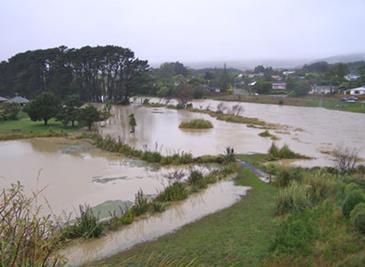
22 3 Key Issues A stocktake was undertaken to better understand the information that the respective councils hold on natural hazards and hazard risk, and how these risks are currently managed. The stocktake prov ides an initial identification of key issues in relation to consistency in approach and application of good practice in hazard management and planning provisions used by different local authorities. The key issues were grouped around: Information gathering Planning provisions Operational responses. The issues are summarised in Table 3-1. This highlights both the need for and the potential benefits of integrated and consistent approaches across the various local government agencies. Table 3-1: Key Issues INFORMATION GATHERING Earthquakes There is a marked variability of earthquake information mapped and available online through council GIS systems. Council staff awareness of the existing information held by other agencies is limited. Coastal Hazards Flooding There is inconsistency in the ways that the councils identify and map coastal hazards. There is little use of coastal hazard information internally within councils. There is a lack of progress in preparing and adopting long term climate change adaptation plans. Large variations in the knowledge of coastal hazards was found, with reliance on tsunami evacuation maps and an increasing need to incorporate sea-level rise. There are discrepancies between Council staff and local residents about the reliability of the knowledge base and/or levels of risk acceptance. Improvements are needed in the mapping of residual flood risks (i.e. potential losses if flood protection is breached or overtopped). Sea-level rise considerations are not yet adequately integrated into the mapping of flood risk in coastal areas. Flooding hazards are generally well documented and mapped with greater regional consistency than other natural hazards. General Comments There is variability in approach and methodologies in managing natural hazard risks. It is not clear whether this variability is driven by specific contextual reasons, by a simple lack of coordination or by differing resource levels 15. There is limited justification of the hazard priorities within plans. It is not clear how hazard 15 It was recognised however that some variation may be appropriate to reflect varying hazard landscapes within the region. Status: Draft for Consultation September 2016 Page 8
23 INFORMATION GATHERING priorities have been chosen. There is no systematic or strategic approach for determining what is important. PLANNING PROVISIONS There is a lack of information and provisions relating to liquefaction hazard. The information contained in planning documents, and explanations of the basis for planning provision for coastal hazards is limited. There is a lack of information about provisions relating to flood hazards in planning documents. A common theme is for this information to relate to only certain water bodies, without explanation as to why this is the case. While landslides are addressed in some district plans, this tends to be through earthworks provisions. Naturally occurring or historical landslide hazard are not provided for. There is minimal recognition in planning documents of other hazards and of climate change issues. There is limited progress towards the integration of a risk based planning approach and risk assessment in natural hazards provisions. (Some progress is evident in more recent updates, but little evidence of this element of good practice where there are older provisions). The district plans also provide little explanation as to why their focus is on some natural hazards and not on others. While cross boundary issues are acknowledged in plans, little direction is provided on how these issues should be addressed. There is a lack of hazard specific provisions in the District Plans. At present the objectives, in particular, tend to be generic to all natural hazards and do not provide clearly identifiable or measureable outcome statements. The planning approaches are often outdated, are not based on a clear risk based model and do not meet good practice tests. Related to this, there is no clear evaluation involving community input about what levels of risk are considered acceptable. OPERATIONAL RESPONSES Monitoring There is no systematic approach to the monitoring of hazards risk outcomes or the effectiveness of risk reduction. There are key gaps in the monitoring protocols associated with landslides and coastal erosion. Information Management There is a lack (in most councils) of a protocol relating to the review and updating of information. Some councils are taking an ad hoc approach, and seem to be reliant on external parties to provide updated information. There is no indication that a coordinated approach is being taken by councils in relation to the management and updating of information. In some instances councils are relying on older data and information, which does not meet current good practice expectations. The quality of information and accessibility to information about natural hazards varies Status: Draft for Consultation September 2016 Page 9
24 PLANNING PROVISIONS considerably. The level of uncertainty in the information is not always explicitly recognised. Climate Change Councils have different approaches to and levels of understanding of adaptive planning practices. There is a need for clarification around the source(s) of climate change projections, the planning timeframes being used and how they are being applied by the different councils. Councils and some residents continue to have different beliefs about climate change overall, which then impacts on understanding and appreciations of the projections and scenarios, levels of risk acceptance, and planning for the future in general. Status: Draft for Consultation September 2016 Page 10
25 4 Strategy 4.1 Vision Statement The communities of the Wellington region work together to understand and reduce risks from natural hazards to survive and thrive in a dynamic world 4.2 Objectives 1. Our natural hazards and risks are well understood. [Knowledge and Understanding] 2. Our planning takes a long term risk-based approach. [Planning] 3. Consistent approaches are applied to natural hazard risk reduction. [Consistency] 4. We have an agreed set of priorities to reduce the risks from natural hazards. [Prioritisation] 4.3 Principles 1. Use the best available hazards information/science. 2. Identify and agree what is best practice for natural hazards management and reduction. 3. Identify and address what inhibits good practice in natural hazards management. 4. Bring the community along on the journey 5. Build in regular monitoring and review programmes. 4.4 Actions The following actions address the issues and set out steps to achieve the four objectives that have been identified. Status: Draft for Consultation September 2016 Page 11
26 Inception Workstream: Research & Information Wellington Region Natural Hazards Management Strategy ACTIONS TO MEET OBJECTIVES (Five Year Framework) TIMING WHO IS INVOLVED? COST (H,M,L) PRIORITY (H,M,L) OBJECTIVE 1 Our natural hazards and risks are well understood (Knowledge and Understanding) Working together as Councils 1.1 Strengthen the multi-council approach of working collaboratively and collectively. Year 1 Steering Group L H Establish a Natural Hazards Steering Group which will be the custodian responsible for overseeing the implementation of the strategy. Year 1 Programme Advisory Group L H Establish a technical advisory group to assist the Steering Group, where necessary, on the implementation of the strategy. Year 1 Steering Group L H Develop and maintain a programme to continually evaluate the effectiveness of objectives and achievement of actions (incorporating performance measures). Year 1 Steering Group 1.2 Develop and maintain a regionally consistent information base about natural hazards (and community exposure to them). Refer to Appendix B and build on this information. Develop common terminology and definitions for natural hazard management. Develop common/shared Information Management Protocols. Years 1-5 Year 1 Year 1 Steering Group assisted by Technical Advisory Group M H Establish a mechanism to regularly update and share the latest scientific information. Years 1-2 Monitor natural hazard trends in the region, including recording the occurrence of extreme events. Years 1-5 Status: Draft for Consultation September 2016 Page 12
27 Workstream: Research & Information Workstream: Education Wellington Region Natural Hazards Management Strategy ACTIONS TO MEET OBJECTIVES (Five Year Framework) TIMING WHO IS INVOLVED? COST (H,M,L) PRIORITY (H,M,L) 1.3 Develop, fund and co-ordinate agreed natural hazards research programmes. Identify, programme and prioritise research. Years 1-5 Steering Group, GW and Councils assisted by Technical Advisory Group M H Working with our Communities 1.4 Provide for ongoing community resilience through education and information about long-term risk reduction across a range of natural hazards. Years 1-5 Steering Group, WREMO, Business, Professional, Services and Community Organisation s L M 1.5 Encourage better understanding of risks by all stakeholders on an ongoing basis Years 1-5 Councils, Community, Businesses L M OUTCOMES: Councils and communities have a good understanding of the risks associated with natural hazards and will be in a position to make well informed decision. PERFORMANCE MEASURES: Community Surveys/Responses (using established practices); Use the Long Term Plan process to plan actions, with a link to funding and definitive timeline. Status: Draft for Consultation September 2016 Page 13
28 Workstream: Planning Workstream: Education Wellington Region Natural Hazards Management Strategy ACTIONS TO MEET OBJECTIVES (Five Year Framework) TIMING WHO IS INVOLVED? COST (H,M,L) PRIORITY (H,M,L) OBJECTIVE 2: Our planning takes a long term risk-based approach (Planning) Working together as Councils 2.1 Summarise all risk based methodologies and agree on consistent approaches for each type of hazard. Year 1 Steering Group, Technical Advisory Group, Lifelines Groups L H 2.2 Ensure that the different timeframes over which natural hazards are likely to occur are recognised and provided for. Year 1 Steering Group L H Working with our Communities 2.3 Raise awareness about community needs and educate about council responsibilities for managing impacts from natural hazards (eg, in land use planning). Prepare a community engagement plan and undertake regular consultation with communities. Years 1-5 Steering Group WREMO Insurance industry M H OUTCOMES: Councils and Communities understand and agree what is acceptable risk, and base land use and asset planning decisions on th is agreement. PERFORMANCE MEASURES: Damage costs associated with natural hazard events; Demonstration of identification of and response to natural hazards in new developments and existing established areas (e.g. across contents of regional, district, and asset management plans) Status: Draft for Consultation September 2016 Page 14
29 Workstream: Planning Wellington Region Natural Hazards Management Strategy ACTIONS TO MEET OBJECTIVES (Five Year Framework) TIMING WHO IS INVOLVED? COST (H,M,L) PRIORITY (H,M,L) OBJECTIVE 3: Consistent approaches are applied to natural hazard risk reduction (Consistency) Working together as Councils 3.1 Develop regionally consistent and coordinated provisions through a set of agreed city/district/regional plan objectives, policies, rules and methods. Prepare jointly across all councils in the region and obtain buyin from communities at an early stage (single process, single cost, rather than repeated multiple times, with duplicated costs). Years 1-5 Steering Group, Council Planners M H 3.2 Cooperate on common issues depending on the nature of the hazard. Develop common standards or management plans for assets across the region for network utilities (e.g. Wellington Water). These should be cross-referenced to development planning. Years 1-5 Steering Group, Council Planners L H Formulate principles for decision-making, construction and urban design guidelines for hard protection structures (e.g. seawalls). Status: Draft for Consultation September 2016 Page 15
30 ACTIONS TO MEET OBJECTIVES (Five Year Framework) TIMING WHO IS INVOLVED? COST (H,M,L) PRIORITY (H,M,L) 3.3 Develop joint funding proposals for Long Term Plans and Annual Plans where there are areas of common concern around natural hazard planning. Years 1-5 Steering Group L Working together with our communities 3.4 Strengthen linkages between planning practices and existing emergency management programmes. Years 1-5 Steering Group, WREMO, L M Council Planners OUTCOMES: Councils follow a consistent approach in implementing practices and planning principles. PERFORMANCE MEASURES: Measure against findings of the Stocktake and Issues Report, and evolving good practice. Status: Draft for Consultation September 2016 Page 16
31 Workstream: Planning Workstream: ALL Wellington Region Natural Hazards Management Strategy ACTIONS TO MEET OBJECTIVES (Five Year Framework) TIMING WHO IS INVOLVED? COST (H,M,L) PRIORITY (H,M,L) OBJECTIVE 4: We have an agreed set of priorities to reduce the risk from natural hazards (Prioritisation) Working together as Councils 4.1 Recognise existing capabilities and agreeing to a forward work programme. Years 1-2 Steering Group L M Develop a set of criteria to determine priorities and identify quick wins (e.g. priorities to be aligned with national, regional and district plans). Year 1 L H Identify and apply the range of tools to inform decision-making on vulnerabilities and likely effectiveness of actions. Years 1-2 L H Develop a regional resource base to build capacity and up-skill staff and community representatives. Years 1-5 M M 4.2 Assess risk and provide targeted planning guidance (to avoid, mitigate and/or remedy). Prioritise actions at regional level but also recognise local conditions and differences in the nature and risk of hazards. Years 1-5 Years 1-5 Steering Group assisted by Technical Advisory Group M M H M Working with our Communities 4.3 Engage with partners in prioritisation of decisions. Years 1-5 Councils, Iwi L H 4.4 Work with reference groups and involve other methods of community input into prioritisation. Years 1-5 Steering Group M M Community Status: Draft for Consultation September 2016 Page 17
32 ACTIONS TO MEET OBJECTIVES (Five Year Framework) TIMING WHO IS INVOLVED? COST (H,M,L) PRIORITY (H,M,L) OUTCOMES: Councils and Communities work towards an agreed set of priorities that are reflected in the Regional Policy Statement and R egional and District Plans, Annual and Long Term Plans, and Asset Management Plans. PERFORMANCE MEASURES: Measure against findings of Stocktake and Issues report; Inclusion of actions in Long Term and Annual Plans; The number of actions or activities successfully implemented. Status: Draft for Consultation September 2016 Page 18


33 4.5 Implementation Plan The following diagram illustrates the organisational structure for implementation of the Strategy s actions from section 4.4. The phasing and basis of funding for the Strategy is set out in further detail in this section. The Plan is based on a five-year timeframe, after which its effectiveness will be reassessed 16 and its continuation will be reviewed. Community Inputs Natural Hazards Steering Group Technical Advisory Group Develop Workstreams Research Education Planning Develop Programmes - Consistent information availability - Targeted research strategy Develop Strategy to inform, educate and up-skill for - Councillors - Communities - Public as stakeholders Prepare - Guidance on consistent risk based approaches - Geographic Natural Hazard Management Plan - Model plan provisions and asset strategies Figure 4-1: Implementation Structure Community 16 See Outcomes and Performance Measures in section 4.4. Status: Draft for Consultation Page 19 September 2016
34 Inception Phase During Year 1 the Natural Hazards Steering Group (the Steering Group) will be established. The current Programme Advisory Group will prepare the terms of reference for the Steering Group, for confirmation/approval of the Coordinating Executives Group (CEG). The Steering Group is to be the multi-council custodian, overseeing the implementation of the Strategy. It is envisaged that there will be a representative of each council (at the technical level, e.g. a dedicated number of the planning or asset management team). The Steering Group members are responsible for reporting to their respective councils to ensure that important decisions are made, particularly around the commitment to funding/resourcing for the Strategy. The Steering Group will establish a Technical Advisory Group (TAG) consisting of the representatives of appropriate central government agencies, the Insurance Council, and research providers such as GNS, NIWA, BRANZ and other agencies. The TAG will be convened as necessary to assist with workstreams in an advisory capacity. The Steering Group will be able to seek advice from the TAG as relevant to the issues to be addressed. The Steering Group will also be responsible for ensuring that there is stakeholder and community input as appropriate within the workstreams. This may involve establishing focus, advisory or reference groups from the wider community or other means of seeking informed community input as the workstreams develop. The Steering Group s role will be facilitated by a dedicated project/programme manager, who will also be responsible for overall management of the workstreams, regular review of achievements and reporting to the CEG Develop Workstreams The Steering Group will develop a number of workstreams to implement the actions. The workstreams fall into three main groupings: Research/Information Education Planning. Each workstream will be convened and co-ordinated by an appropriate owner to be determined by the Steering Group, under the overall management and support of the strategy s project/programme manager. Box 1 sets out ways of working under each workstream which have been developed in parallel with the Strategy s objectives and actions Research/Information Each participating local authority has staff who are already involved in collecting information, maintaining hazards databases and presenting the information in various ways including through GIS systems. Each also obtains information through commissioned work and through services such as resource consent application assessments. As well as co-ordinating and aligning information collection, storage and presentation, the workstream will involve identifying and filling information gaps and identifying means of ensuring that hazard information is readily available within councils and for the community. Much of this workstream will rely on existing budget and staff allocations, and additional research finding will be justified on a case-by-case basis. It is anticipated that GW would lead this component of the Strategy, with the active input of appropriate staff from all participatory local authorities Education This essential workstream has a broad mandate of education and upskilling, and requires a comprehensive strategy and sustained performance over the full five years of the programme to raise Status: Draft for Consultation Page 20 September 2016
35 knowledge and understanding of natural hazard risks and the importance of risk reduction. It will be undertaken in partnership with WREMO and other initiatives (such as the publicity and public information associated with the Wellington Resilience Strategy). It is expected that this component of the strategy would be led by a dedicated person within the GW communications and marketing team, working closely with the communication team at WREMO and in the participatory councils. The Strategy s project/programme manager would however have direct responsibilities relating to professional and industry organisations within this workstream Planning This workstream is likely to involve commissioning of consultancy advice, in addition to work that may be led from and undertaken collaboratively within the participatory councils themselves. Scoping of work under the four items identified here will need to be completed by the Steering Group at a very early stage, as there is a pressing need for achievement under this heading relating to the content and alignment of the various district plans in the region Implementation The actions will be implemented under the relevant workstream. The programming, coordination and prioritisation of the work will be undertaken by the programme/project manager assisting the Steering Group. There will be ongoing engagement with stakeholders and the community throughout the entire implementation process, led and managed through the project/programme manager or through specific commissioned work (for example, in development of plan provisions) Funding The funding of the majority of actions identified in the Strategy can be done through existing council budgets, through alignment of programmes and co-ordinating of staff responsibilities. Budgets in annual plans and long term plans, including those for review of district plans and web based information portals will allow for a coordinated council approach in allocating funds for the Strategy. It is anticipated that the role of the project/programme manager will require an additional full-time position, to be located within GW, involving either the diversion of existing staff, funding or additional allocation. New projects, as may be needed to meet research/information activities needs, additional communication effort and commissioned planning advice will be identified in annual plans or long term plans through a coordinated council approach to pooling resources for the effort into natural hazard reduction. Status: Draft for Consultation Page 21 September 2016
36 Box 1: Ways of Working Workstreams General There is ongoing and improved liaison between councils, across all disciplines but particularly on land use matters, through good communication. Recognise and incorporate national guidance (e.g. NZCPS, CDEM Group Plan, other strategies and research programmes). Research & Information Apply good practice guidance in collecting and managing hazards information (refer Appendix D). Hold data developed by consultants for Council projects in a shared database (IP issues to be addressed). Focus science research spending to practically inform risk reduction decisions. Partner with other providers. Combine resources to provide for an annual appropriation of funds. Education Engage with the community. Link up with schools, iwi, residents associations and community groups. Arrange information sharing campaigns, using online games and scenario development to understand the reduction of the 4Rs. Build on what is already available online through Council portals. Use information from actual events to leverage actions and discussion. Consistently promote the benefits of good natural hazard information through community and business forums (e.g. run seminars for property lawyers and estate agents). Provide consistent and easy to understand natural hazards information (such as on LIMS). Establish an understanding of the community s acceptance of risk through ongoing community engagement. Listen to the concerns of, and work with, the community and businesses to identify emerging natural hazards issues and risks ( hot-spots ). Promote understanding of the role of the insurance industry and how that reflects risk through cost and availability of insurance cover. Promote understanding of social impacts and wider community interests (through a people-centric approach, emphasising that vulnerable people should not be made more vulnerable). Educate about the precautionary approach in risk reduction. Foster community understanding of the changing risks associated with climate change, and the needs of future generations. Work closely with the Wellington Resilience Officer (100 Resilient Cities). Link up with WREMO s Community Response Plans. Planning Integrate risk evaluations into spatial planning and decision-making on individual projects through consenting, to ensure that natural hazards and risks are taken into account in decision-making. Develop a consistent approach to risk acceptance assessment and the uncertainties associated with risks, recognising that there are known and unknown factors associated with natural hazard risk. Work together to ensure resilience at the regional level. Recognise that many of the region s commercial centres, employment areas and regionally significant infrastructure are in hazardous locations. Ensure an inclusive and integrated approach across all disciplines. Build GWRC s climate change strategy into natural hazards risk reduction management decisionmaking. Agree on planning time horizons to ensure that climate change and sea level rise is built into all plans. Where relevant, apply an adaptive pathways approach to forward planning. Recognise that differences in approach will be needed for greenfields vs developed areas. Ensure consistent responses to legacy issues in land use planning. Consider the role of regional rules in natural hazard management. In order to reflect local conditions, recognise that some actions may require joint approaches, some individual action but based on common methods, and some actions need to be completed at local level only. Develop joint submissions to contribute to other natural hazards management initiatives (e.g. Resilience Strategy for Wellington, RMA changes, new and reviewed NPSs) Improve inter-departmental coordination/liaison within councils (Building Services, Regulatory Planning Services, Infrastructure and Asset Management, GIS etc.) Build on good practice already in place (the stocktake identifies where good practice has been followed). Prioritise actions at regional level but also recognise local conditions and differences in the nature and risk of hazards. Recognised partners to work with across all workstreams include: Iwi; Lifeline Agencies (such as the NZ Transport Agency, KiwiRail, Transpower, Wellington Water); Central Government agencies; and Knowledge providers (CRIs, Universities, other research agencies). Status: Draft for Consultation Page 22 September 2016
37 Glossary A comprehensive Glossary is set out in Chapter 9 of the Coastal Hazards and Climate Change Manual 2008, Ministry for the Environment. The link is here: References (n.d.). Allan, S. (n.d.). Impacts of climate change on urban infrastructure and the built environment : A toolbox; Tool 1.4: Urban Environments and Climate Change - Statutory Context. Retrieved 2015, from NIWA: ment_statutory_context.pdf Building Act. (2004). Ministry of Business, Innovation, and Employment; Reprint as at 1 January Civil Defence Emergency Management Act. (2002). Ministry of Civil Defence and Emergency Management; Reprint as at 1 January GNS Science. (2015 a). Risk-based-planning-approach-and-steps. Retrieved from GNS Science: GNS Science. (2015 b). Natural Hazards: Earthquakes. Retrieved 2015, from GNS Science: GNS Science. (2015 c). New Zealand Active Faults Database. Retrieved 2015, from GNS Science: GNS Science. (2015 d). Risk-based planning approach and steps: Step 1 - Know your hazard. Retrieved 2015, from GNS Science: Greater Wellington Regional Council. (2012). Wellington - highest rate of sea-level rise in NZ. Retrieved 2015, from Greater Wellington Regional Council: Greater Wellington Regional Council. (2013). Regional Policy Statement for the Wellington Region. Wellington: Greater Wellington Regional Council. Greater Wellington Regional Council. (2014). Section 32 Report: Natural Hazards (Preliminary draft for discussion). Wellington: Greater Wellington Regional Council. Greater Wellington Regional Council. (2015). Greater Wellington GIS Viewer. Retrieved 2015, from Greater Wellington Regional Council: Group, Technical Advisory. (2012). Report of the Minister for the Environment s Resource Management Act 1991 Principles Technical Advisory GrouP. Wellington. Lane, E., Gorman, R., Plew, D., & Stephens, S. (2012). Assessing the storm inundation hazard for coastal margins around the Wellington region. Wellington: NIWA Client Report CHC prepared for Greater Wellington Regional Council, Kapiti Coast District Council and Wellington City Council. Local Government Official Information and Meetings Act. (1987). Section 44A: Land information memorandum. Department of Internal Affairs; Reprint March Managing Flood Risk. (NZS9401:2008). Managing Flood Risk A process standard, NZS9401:2008. Standards New Zealand. Status: Draft for Consultation Page 23 September 2016
38 Ministry for the Environment. (2008 a). Climate Change Effects and Impacts Assessment: A Guidance Manual for Local Government in New Zealand. 2nd Edition. Mullan B; Wratt D; Dean S; Hollis M; Allan S; Williams T, Kenny G and MfE. Wellington: Ministry for the Environment. Ministry for the Environment. (2008 b). Preparing for climate change: A Guidance Manual for Local Government in New Zealand. Ministry for the Environment. Parliamentary Commissioner for the Environment. (2001). Building on the edge: The use and development of land on or close to fault lines. Wellington: Parliamentary Commissioner for the Environment. Power, W. (2013). Review of Tsnunami Hazard in New Zealand. GNS Science consultancy Report 2013/131. Quality Planning. (n.d.). Risk-based approach to planning for natural hazards. Retrieved 2015, from The RMA Quality Planning Resource: Ramsay, D., Gibberd, B., Dahm, J., & Bell, R. (2012). Defining coastal hazard zones and setback lines. A guide to good practice. Hamilton, New Zealand: National Institute of Water & Atmospheric Research Ltd. Resource Management Act. (1991). Ministry for the Environment; Reprint as at 3 March Saunders, W., Beban, J., & Coomer, M. (2014). Analysis of natural hazard provisions in regional policy statements, territorial plans, and CDEM Group Plans. GNS Science Report 2014/28. Smith, N. (2015). Next steps in National s Bluegreen agenda. Wild Things Conference; 13th August The New Zealand Coastal Policy Statement. (2010). Policies 24: Identification of coastal hazards; 25: Subdivision, use, and development in areas of coastal hazard risk; 26: Natural defences against coastal hazards; 27: Strategies for protecting significant existing development from coastal hazard risk. UNISDR. (n.d.). Local HFA: Local Government Self Assessment Tool (LGSAT). Retrieved 2015, from Prevention Web: ate_en.pdf Wellington Region Civil Defence Emergency Management Group. (2007). Updated Hazard and Risk Analysis for the Wellington Region CDEM Group Plan. Wellington. Wellington Region Civil Defence Emergency Management Group. (2013). Wellington Region Civil Defence Emergency Management Group Plan Wellington. Status: Draft for Consultation Page 24 September 2016

39 Appendix A Methodology The Strategy has been developed through a series of workshops involving representatives of the councils and a wider group of stakeholders who have participated at different stages. The methodology for the development of the Strategy incorporates five stages: Stage 1: Vision and Objectives Stage 2: Issue Identification Stage 3: Draft Action Plan Stage 4: Local Government Act hearing processes Stage 5: Confirmation and implementation of the Strategy. Methodology for the development of the Natural Hazard Management Strategy Stage 1: Vision and Objectives The vision and objectives were first developed, along with a series of principles. These were made available for public review. Stage 2: Issue Identification A Stocktake and Issues Report 17 forms part of Stage 2 Issue Identification and outlines the results of a stocktake to better understand what information currently exists across the respective councils on hazards and hazard risk, and how these risks are currently managed. The stocktake provided an initial identification of key issues in relation to consistency in approach and application of good practice in hazard/risk mapping and planning provisions used by different local authorities. Stage 3: Draft Action Plan (subject of this report) Numerous actions to achieve the objectives were then developed through further engagement, and refined into: A concise set of actions and an implementation plan. An equally important set of ways of working which will help to inform and provide guidance to those engaged in the actions. 17 Report available on this link: 16.pdf Status: Draft for Consultation Page 25 September 2016


40 Governance and Reporting The following diagram sets out the governance and reporting structure that has been followed in the preparation of the Strategy. Timeline The following timeline illustrates what has been completed and what the next steps are: Status: Draft for Consultation Page 26 September 2016
41 The Project Team Dr Iain Dawe, Senior Policy Advisor (Hazards), Greater Wellington Regional Council Sylvia Allan, Allan Planning & Research Ltd Caroline van Halderen, Senior Planner, MWH Council Representatives (the representatives varied over the period of the project) Matthew Hickman, Greater Wellington Regional Council Jonathan Streat, Greater Wellington Regional Council Sharyn Westlake, Greater Wellington Regional Council Lucy Harper, Greater Wellington Regional Council Tracy Berghan, Greater wellington Regional Council Nicola Etheridge, Upper Hutt City Council Drew Cumming, Hutt City Council John McSweeney, Wellington City Council Mitch Lewandowski, Wellington City Council Matt Trlin, Porirua City Council Peter Matich, Porirua City Council Alison Lash, Kapiti Coast District Council WREMO Bruce Pepperell Sarah Gauden-Ing Technical Experts Dr Rob Bell, Principal Scientist, Coastal and Estuarine Physical Processes, NIWA Dr Andrew Tate, Principal Scientist, Climate, NIWA Dr Graeme Smart, Principal Scientist, Natural Hazards and Hydrodynamics, NIWA Chris Robson, Engineering Geologist, MWH Status: Draft for Consultation Page 27 September 2016
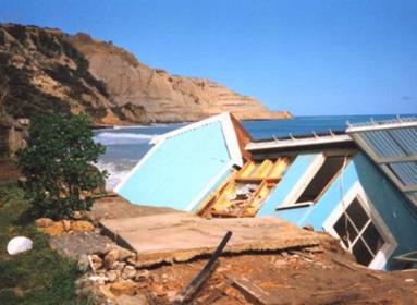
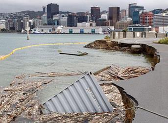
42 Appendix B Description of Natural Hazards in the Wellington Region Natural events become hazardous when they adversely affect human lives. The Wellington region has one of the most physically diverse environments in New Zealand. It is also one of the most populous regions and, consequently, communities are affected by a wide range of natural hazards. The Wellington Region Civil Defence Emergency Management group developed a comprehensive hazard and risk analysis report describing the region s most at-risk areas from its relevant hazards in 2007 (Wellington Region Civil Defence Emergency Management Group, 2007). This report combined with the Regional Policy Statement for the Wellington Region provides the background information on hazards and risks within the Wellington region (Greater Wellington Regional Council, 2013). Earthquakes The Wellington region is located within an area of high seismicity near the boundary of the Pacific and Australian tectonic plates. Stresses in the earth s crust produced by the subduction margin have produced a number of faults, both on land and on the seafloor, around the Wellington region. Many of these faults are still active and present a significant hazard. Earthquakes are caused when stresses that have built up on these faults are released, creating earthquake hazards of surface fault rupture, ground shaking and, in some areas, liquefaction (and potentially landslides and tsunami which are covered in a separate section of this report). The five faults that could potentially cause the most damage in the region are shown in the table below together with their recurrence intervals and maximum magnitudes. Recurrence Interval & Maximum Magnitude for Five of Wellington s Most Potentially Damaging Faults Fault Recurrence interval (yrs) Elapsed time since last event (yrs) Maximum Magnitude (Richter Scale) The Wellington Fault ~ 900 ~ Ohariu Fault and North Ohariu ~ Wairarapa Fault ~ Carterton Fault unknown 7.0 Masterton Fault ~ 1000 unknown 6.7 Surface fault ruptures occur particularly in sufficiently large (magnitude 7.0+) and shallow (< 40 m) earthquakes where the fault movement may cause vertical uplift / downthrust or horizontal / lateral movements that deform the ground surface. Of particular interest are high magnitude earthquakes (7.0+) from the rupture of a local fault (especially the Wellington Fault). Ground shaking is the most widespread effect of an earthquake and is usually most severe closest to the fault. On release, waves of energy travel through the ground and produce a shaking effect. When the waves reach ground level, they slow down and are transformed into surface waves that produce either a vertical or lateral movement. The ground shaking is influenced by surface geology. In loose unconsolidated sediments such as gravels, sands and silts, ground shaking effects can be amplified. Areas likely to experience the highest amplification include reclaimed land around central Wellington, Kilbirnie, Rongotai and Miramar, Petone, Lower Hutt, Wainuiomata, Mangaroa Valley and low-lying areas around Porirua Harbour and Pauatahanui. Status: Draft for Consultation Page 28 September 2016
43 Liquefaction occurs when unconsolidated soils, particularly silty and sandy soils, become saturated with water in a shaking event and behave more as a liquid than a solid. Liquefaction has a range of associated effects such as ground subsidence, lateral spreading, landslides, foundation failures, flotation of buried structures and water fountaining. Areas at risk in the Wellington region include reclaimed land around Wellington City; Hutt River mouth and lower floodplain (Petone, Seaview, Gracefield); Porirua CBD and Pauatahanui; low lying areas on the Kāpiti coast, and areas built on drained/reclaimed watercourses or swamps (e.g. Wainuiomata, Miramar Peninsula interior and Kilbirnie). Coastal Hazards With over 500 km of coastline, the Wellington region is exposed to coastal hazards from a range of sources. Coastal hazards encompass coastal erosion and inundation, sea-level rise and tsunami. Coastal erosion and inundation, often associated with storm surges and wave overtopping, have the capacity to cause significant damage to infrastructure and flooding in low-lying coastal areas. Storms in the Wellington region generally come from three main sources: southerly storms usually in winter, northwest storms persisting in spring and ex-tropical cyclones typically in summer and autumn months. A storm surge is the short term elevation of the local sea level due to meteorological conditions of wind set-up and barometric lift (inverse barometer effect from relaxation of sea surface during low atmospheric pressure). Waves cause an additional wave setup through the surf zone and then run-up on the beach or seawall. Around the Wellington region a combined storm-tide and wave setup elevation with a return period of 100 years is around m (Otaki-Kāpiti), m (south Wellington), and 1.5 m (Wellington Harbour) above Wellington Vertical Datum (Lane, Gorman, Plew, & Stephens, 2012). Due to a mix of natural processes of geology, tectonics, sediment supply, wave exposure, storm -tide and relative sea-level rise, some sections of the coastline are in long term retreat such as Paekākāriki and Te Kopi on the south Wairarapa Coast. Other areas have episodes of erosion that form part of a cycle of erosion and deposition (such as Paraparaumu). Storm-tide, wave run-up and associated coastal erosion can also cause inundation. Places particularly susceptible to coastal flooding and overtopping include areas on the Kāpiti Coast (Raumati South, Paekākāriki), Wellington south coast (Island Bay, Lyall Bay) and Wellington Harbour (Eastbourne, SH2, Lambton Quay). Wellington has experienced an average rise in sea level of about 2 mm per year over the past 100 years. Most of this rise is due to climate change but it is being exacerbated by subsidence of the region (lower North Island) over the past decade, caused by slow-slip seismic events from deep tectonic plate movements. Projections for the end of this century indicate that the sea level in Wellington region could rise by 0.8 m by the 2090 s or 1.0 m by 2115 (Greater Wellington Regional Council, 2012), in line with the Ministry for the Environment guidance for coastal hazards and climate change (Ministry for the Environment, 2008 a). A tsunami is a series of waves generated by the sudden displacement of a water surface. The three main generating mechanisms are submarine fault ruptures, underwater or aerial landslides or volcanic activity. The Wellington region is at risk from tsunami generated from both distant (far -field > 3 hr travel time) and local sources (near-field < 1 hour travel time). Regionally-generated tsunami with 1 3 hr travel time (e.g. Solomon Islands or northern Kermadec area) are considered to pose less threat. Earthquakes off the coast of Chile present the largest far-field tsunami risk for the Central New Zealand region, while there are three potential sources of near-field tsunamis: the Hikurangi Subduction Margin of Pacific/Australia Plate boundary off the southeast coast, local faults in Cook Strait and submarine landslides off Cook Strait Canyon (Power, 2013). Flooding A flood occurs when an area of land, usually low-lying, is inundated with water from river flooding, flash floods or ponding. Frequent heavy rainstorms, the steep gradients of many river catchments and human occupation of floodplains combine to make flooding the most frequently occurring natural hazard event Status: Draft for Consultation Page 29 September 2016
44 in the Wellington region. A heavy rainfall event is defined as 100 mm over a 24-hour period. The classic mechanism in the region for localised severe rainfall is a southerly front meeting a northwest front. The areas of greatest flood risk in the region are those catchments and floodplains that drain both west and east of the Tararua Range, where the highest rainfall occurs. Flood risk also arises from high-intensity short-duration events over, for example 30 minutes to a few hours i.e. flash flooding. River flooding from bank overtopping onto flood plains from prolonged rainfall is a particular risk for the Otaki and Waikanae River flood plains and the Lower Hutt valley. A credible event is a 500 year flooding event on the Hutt River exceeding the design standard of the stop banks. In order for this to occur, heavy intense rainfall from a stationary front bringing over 500 mm of rain over a hour period to the Hutt River Catchment is needed. This would flood the Hutt Valley floodplain as well as causing flooding in the Otaki or Waikanae River valleys. Serious flooding can also occur should flood defences fail before their supposed design capacity is reached. This can occur, for example, due to piping through or under banks, debris jams, out-flanking, bank scouring, bank slumping, landslide induced tsunami and channel capacity loss through inchannel deposition. Sedimentation and erosion of rivers and streams, river mouths and tidal inlets, can be sudden (during an event) or develop gradually over time and can further exacerbate the flood risk by raising bed levels and undermining banks. Flash flooding from intense heavy rainstorms is a high risk in short steep catchments such as in Waikanae, and Paekakariki. Surface flooding or ponding is due to the capacity of stormwater systems being exceeded, impeded drainage (drains being blocked) or antecedent conditions of the water table being high when the ground is waterlogged. This can occur around Porirua Harbour and Pauatahanui Inlet, as well as localised areas, such as the inter-dune depressions on Kāpiti Coast, and parts of Wellington City and Lower Hutt. Other Natural Hazards Landslides The geology, tectonic setting and climate make the Wellington region particularly prone to landslides. These factors combined with inappropriate planning decisions and inadequate engineering design / maintenance make landslides second only to flooding, in terms of the economic costs from damages (Wellington Region Civil Defence Emergency Management Group, 2007). Whether a slope fails or not depends on a balance between the strength of the slope material and the driving or shear stress acting on the slope. Water plays the biggest role in slope failure due to its addition to the mass on the slope. The two main types of antecedent conditions that lead to slips in the region are i) a wet winter with susceptibility increasing towards the end of the period, and ii) a dry summer with a major rainstorm event producing falls of over 200 mm. Based on the region s historical record, there are on average seven significant rainfall-triggered landslide events every year (Wellington Region Civil Defence Emergency Management Group, 2007). The next most common triggering mechanism is earthquake shaking. Strong earthquake shaking of intensity > MM eight is likely to generate large (>100,000 m 3 ) bedrock landslides throughout the region. This intensity of shaking is expected in the region every 170 years on average. Drought Drought is a prolonged period of low rainfall leading to a severe soil moisture deficit. It becomes a hazard when people choose to live (and/or derive their livelihoods from the land) in drought-prone areas or when the drought limits water availability for municipal supply. Research by the GWRC indicates a relationship between the Southern Oscillation Index and seasonal low rainfalls (Wellington Region Civil Defence Emergency Management Group, 2007). La Niña conditions, with predominant easterly/northeasterly flows, often result in lower than average rainfall in Status: Draft for Consultation Page 30 September 2016
45 Kāpiti, the western and southern Tararua Range and the Rimutaka Range. This leads to low flows in the Otaki, Waikanae, Hutt, Wainuiomata and Orongorongo Rivers. Furthermore, if El Niño conditions are present in spring, then summer rainfall is likely to be below average in the central Wairarapa. Wildfire A wildfire is an unplanned blaze that starts in an open space, such as a hillside. Wildfires can be started through lightning strikes, arson, sparks (e.g. from a truck tyre blowout or train), or from out-of-control camp fires. Wildfire risk is heightened during prolonged drought conditions. The way a wildfire spreads will depend on the fuel (e.g. wood, scrub, dry grass/undergrowth), available oxygen, weather conditions (wind speed and direction, temperature, humidity) and slope angle. Around 20 per cent of the land (165,500 hectares) in the Wellington region is at high to extreme risk from wildfire. This land is characterised by gorse and scrub vegetation, steep slopes, low rainfall and proximity to human habitation. The most at-risk areas are the southern and western edges of Wellington, the eastern Hutt hills and areas around Wainuiomata and Eastbourne. Wind High winds can occur throughout the region and can cause widespread damage to buildings, infrastructure and forestry. These winds may also disrupt transport (particularly ferry crossings and plane landings), and impact on power and telecommunication lines. The windiest areas are generally along Wellington s coasts. Westerly winds, turned south by the Tararua Range, are funnelled through the gap of Cook Strait to produce strong north or north-westerly winds in the western Wellington region. Southerly winds flow parallel to the main Wellington ranges and are not as strong or as characteristica lly gusty as the north-westerly, however, they have higher average sustained wind speeds. The return period for a severe wind gust (sustained over 3 seconds) of 200 kph is roughly 140 yr (Wellington Region Civil Defence Emergency Management Group, 2007). Lightning Lightning occurs most frequently in the region during northwest storms but can also occur when a cold dry southerly front meets a warm moist northerly front, or from cumulonimbus thunder cells. Higher incidence of lightning strikes occur in the Tararua ranges, north Wairarapa and Kāpiti Coast. On average, there are between 0.15 and 0.7 lightning flashes per square kilometre every year in the region. Risk from lightening is low and can be reduced to near zero if basic precautions are undertaken (Wellington Region Civil Defence Emergency Management Group, 2007). Snow and Hail Hail can occur in southerly storms, when a cold dry southerly front meets a warm moist northerly front, or from convection thunder cells (cumulonimbus) on warm summer days. Hail is considered severe when it is over 30 mm diameter (golf ball size) (Wellington Region Civil Defence Emergency Management Group, 2007). Snowfalls occur in the region in winter and early spring each year. These falls are generated from southerly storms, and are particularly located in the Hutt Valley, SH1 north of Paraparaumu and elevated areas above 500 metres. Heavy snowfall is regarded as more than 25 cm falling in a 24 hr period or 10 cm in 6 hrs. Falls below 200m above sea level are infrequent but 1 per year may be expected at between m and 5 per year at m (Wellington Region Civil Defence Emergency Management Group, 2007). Volcanic Hazard There are no volcanoes in the Wellington region. However, there is a residual risk from ash fall from volcanic eruptions in other areas. Based on the 1995 and 1996 Mt Ruapehu eruptions the extent of ash fall for the Wellington region is estimated to be around 1 mm if winds are from northwest direction. The consequences of ash fall include human health impacts, economic impacts such as damage to property, clean-up costs, contamination of water supplies and possible closure of the airport. Status: Draft for Consultation Page 31 September 2016
46 Appendix C Planning Legislative Framework This section outlines the planning provisions that councils use for managing natural hazard risk. To understand this it is necessary to consider the wider RMA framework. Resource Management Act The Resource Management Act 1991 (RMA) provides a mandate for councils to manage natural hazards, climate change impacts and the effects of hazard mitigation measures on the environment and is the primary statute for promoting hazard provision in regional and district plans. The legislation reflects the concept that decisions which affect local communities should be made by those communities. While natural hazards are not specifically mentioned in Part 2 of the RMA, there are many activities involved in the mitigation of natural hazards that may be considered under Part 2 matters. There are a number of sections and subsections under Part 4 of the RMA that require regional and district councils to manage the effects of natural hazards and to gather information, undertake research and keep records of natural hazards, viz s30(1), s35(1) and S35(5j) (Resource Management Act, 1991). Subdivision and land development is controlled through the RMA. The legislation grants local authorities powers under s106 (and s220) to refuse subdivision if the land is prone to natural hazards. Whilst this is an important provision, regional and district plans would incorporate adequate limitations to prevent the subdivision and development of at-risk land, or ensure mitigation methods for any development that does take place (Allan, n.d.). The Minister for the Environment s recent speech to the Environmental Defence Society s conference reconfirmed the current Government s intent to secure better management of natural hazards through changes to the RMA (Smith, 2015). Details on these changes are yet to be released. National Policy Statements and National Environmental Standards National Policy Statements (NPSs) provide direction to local government on how c ompeting national benefits and local costs should be balanced. National environmental standards (NESs) are regulations that set baseline nationwide minimum standards for particular issues. While there are yet no national policy statements or national environmental standards addressing particular natural hazards, the New Zealand Coastal Policy Statement 2010 (NZCPS 2010) identifies coastal erosion and other natural hazards as a key issue facing the coastal environment. The NZCPS includes policies on the identification of coastal hazards (The New Zealand Coastal Policy Statement, 2010). These policies relate to at least a 100-year planning horizon, subdivision, use and development in areas of coastal hazard risk; natural defences against coastal hazards; and strategies for protecting significant existing development from coastal hazard risk. The Minister for the Environment recently confirmed the Government s intent to pursue a National Policy Statement on Natural Hazards, in addition to changes to the RMA itself, which will strengthen the system for managing risk from natural hazards (Smith, 2015). Given the anticipated RMA reforms and their focus on the management of natural hazards, local authorities will need to be aware of developments at the national level in the event that new NPSs and NESs are developed and consider whether and how to incorporate such documents into their RMA plans and decision-making. Wellington Regional Policy Statement The Wellington Regional Policy Statement (RPS) (operative from 2013) sets out the framework and priorities for resource management in the Wellington region, including natural hazards. The RMA requires all regional councils to produce an RPS for their region and to review it every 10 years. Regional and district plans must give effect to the RPS. The current RPS for the Wellington Region takes a general all hazards approach and mentions all the main hazards experienced in the region. Status: Draft for Consultation Page 32 September 2016
47 There are a number of non-regulatory methods in the RPS that will assist in managing natural hazards, both explicitly and indirectly in the regional plan. These methods relate to the sharing and collection of hazards information, integrating management across administrative boundaries and assisting with biodiversity restoration projects. To ensure integration with other hazard management activities in the region, the preparation of hazard provisions in the regional policy statement is linked with work being undertaken, and priorities established, as part of the Wellington Region Civil Defence Emergency Management Group Plan (CEDM Group Plan). Wellington Regional Plans Regional plans address specific hazard issues relevant to regional council functions including coastal hazards, floodplain management, land stability and geothermal hazards. A regional council can prepare a specific natural hazard regional plan; however, the interrelated nature of hazards with other environmental features or effects means that natural hazard provisions are generally dispersed amongst various sections of other regional plans. Regional plans can contain objectives, policies and rules addressing natural hazards. Unlike district councils, regional councils can have rules in regional plans for controlling land (for the purposes of avoiding or mitigating natural hazards) that are exempt from existing use right clauses under s10(4) of the RMA. This makes them particularly useful in managing natural hazard risk in areas where development has taken place before plan rules to manage these risks could be implemented. Regional plans generally include rules requiring resource consents and set out specific objectives and policies against which such consents are measured. In Wellington, there is no regional plan for natural hazards, but there are hazard-related policies in the coastal, freshwater and soils plans. The regional coastal plan has hazard policies relating to occupation, use and disturbance of the foreshore, the freshwater plan deals with flood hazards and mitigation, and the soils plan has policies relating to soil erosion (Greater Wellington Regional Council, 2014). The regional plans are currently under review in the proposed Natural Resources Plan (NRP), which was publicly notified in late July The proposed NRP combines coastal and regional plans and incorporates regulatory and non-regulatory methods. It is taking a general hazards approach without singling out individual hazards. Council District Plans Territorial authorities are required to prepare a district plan for their district and these plans are required to give effect to regional policy statements. Territorial authorities, when reviewing their district plan, need to be aware of the direction outlined in a regional policy statement, and how that sh ould be implemented through their district plan. The Wellington RPS directs councils to identify high hazard areas and avoid inappropriate development in those areas. Wellington City Council (WCC), Porirua City Council (PCC), Hutt City Council (HCC), Upper Hutt City Council (UHCC) and Kāpiti Coast District Council (KCDC) are all involved in developing the proposed Natural Hazards Strategy. The current RPS post-dates the development of most of their district plans. New plans and plan reviews need to provide clear direction through policy, rules and other means as to the approach and the desired outcomes sought in managing natural hazard risk. Other It is also important to consider non-rma legislation available to manage natural hazards. The Local Government Act, Building Act and the Civil Defence Emergency Management Act are complementary to the RMA, and whilst these have different functions in relation to natural hazards management they are particularly relevant for the NHMS. Furthermore, specific to flooding hazards, NZS 9401:2008, the Soil Status: Draft for Consultation Page 33 September 2016
48 Conservation and Rivers Control Act 1948 (SCRCA), Land Drainage Act 1908 (LDA), and the River Boards Act 1908 (RBA) also form part of the statutory context. This context is summarised below. Local Government Act 2002 The Local Government Act (LGA) focuses on the functions and operations of local government and includes financial management, and provision and management of community infrastructure. The Act requires local authorities to prepare Long Term Plans (LTP) to describe the activities and strategic direction of the local authority over a 10-year period. The main tool for addressing risk management for key community assets is the Asset Management Plan which deals with the procedures and works required to meet functional requirements of assets and infrastructure. Both these plans are expected to include (and continue to review) climate change risks on an ongoing basis, using up-to-date information on the extent and likely effects of potential change. Building Act 2004 The Building Act prescribes the legal requirements for all buildings and includes sustainability as its core purpose. The Act allows local authorities to delay building work until a resource consent is obtained and can apply where development is taking place on hazard-prone land where plan rules require a resource consent (s37) (Building Act, 2004). The Building Code is a regulation that accompanies the Building Act and is required to take account of all physical conditions that may affect a building, including temperature, water, snow, wind, differential movement, time-dependent effects and reversing and fluctuating effects. The Building Code also applies to site works, which must take into account changes in groundwater level, water, weather and vegetation, and ground loss and slumping. Under the Building Code, structural elements of buildings and elements that are difficult to replace must be designed for a life not less than 50 years. This provision is for the protection of life in a hazard event, rather than maintaining the integrity of the building. Civil Defence Emergency Management Act 2002 One purpose of the Civil Defence Emergency Management Act 2002 (CDEM) is to improve and promote the sustainable management of hazards in a way that contributes to the social, economic, cultural and environmental well-being and safety of the public, and also the protection of property (s3) (s4) (s7) (Civil Defence Emergency Management Act, 2002). The Act provides for planning and preparation for emergencies and for response and recovery in the event of an emergency. While it focuses on emergencies and appropriate responses, it also has strong community engagement and risk management aims. The CDEM Act requires the CDEM Group 18 to produce a group civil defence emergency management plan. The broad purpose of a CDEM group plan is to enable the effective and efficient management of natural, biological and technological hazards for which a coordinated approach would be required to manage an incident. The second generation Wellington Region Civil Defence Emergency Management Group Plan (CDEM group plan) was made operative in 2013 (Wellington Region Civil Defence Emergency Management Group, 2013). In addition to containing operating procedures for the response to hazard events, it also analyses all the hazards that affect the region and ranks them according to their effects and the vulnerability of the community. NZS 9401: CDEM groups are made up of territorial authorities, regional council, emergency services and lifeline utilities. Status: Draft for Consultation Page 34 September 2016
49 NZS 9401:2008 provides a risk-based approach for the management of flood risk. The standard requires: A broad understanding of the natural and human systems from catchment headwaters to the seas, their interactions and the significant factors that affect flooding and in its impact on society A rigorous basis for managing flood risk, within broadly defined and evolving concepts of sustainability and the behaviour of natural systems Comprehensive assessment of risks associated with floods, and their management; Involvement of all stakeholders Definition and agreement on the roles, responsibilities and function for flood risk management among individuals and organisations from local to national level. Soil Conservation and Rivers Control Act 1948, Land Drainage Act 1908 & River Boards Act 1908 These three Acts provide operational powers for regional councils and territorial authorities to carry out works to protect property from flood damage and prevent soil erosion. The SCRCA is the most important of these for taking active steps to prevent flooding or control its effects (Technical Advisory Group, 2012). The powers of local authorities under these Acts are subject to the RMA. For example, section 13 of the RMA places a restriction on certain uses of beds of lakes and rivers unless expressly permitted by a national environmental standard, regional plan or resource consent. Activities undertaken under these Acts need to comply with this restriction. Further, while the Acts provide authorities with powers to enter and use property to manage flood risk, they are subject to existing protection for private property rights (Technical Advisory Group, 2012). The Government has been considering for a number of years whether to repeal these Acts and include their relevant provisions in other legislation (such as the LGA). Status: Draft for Consultation Page 35 September 2016

50 Status: Draft for Consultation Page 36 September 2016
51 Appendix D Good Practice This section provides a broad summary of Good Practice for natural hazard management. The summary is based on input from the project technical experts and also on existing good practice material. Where existing good practice material is used the relevant references are provided. Nonreferenced statements are based on the views of the project technical experts. Hazard and Risk Information This section provides an overview of good practice in terms of collection of natural hazard information. Hazard information is clearly important to the management of natural hazards as it informs quality decision-making processes. The detail of the information gathered should be proportionate to the nature of the decision -making process, e.g. higher level regional policy will need less detailed information, while land use regulation intended to apply at a property-by-property level requires more detailed information. In this respect the Quality Planning website, (Quality Planning), recommends varying scales for hazard mapping based on the intended end-use, as follows: Regional (1:100,000 to 1:500,000) Medium (1:25,000 to 1:50,000) - typically municipal or small metropolitan areas Small (1:5,000 to 1:15,000) - typically site or property level. This scale is recommended for district plan hazard mapping. Good practice also includes knowledge of and active use of online resources which contribute to a combined approach for the region. By way of example, key resources which should be utilised for good practice in determining earthquake hazards are set out below in the table. Contributing to the updating of these resources will ensure a greater shared knowledge of natural hazards. Earthquake Hazard Key Resources Resource GNS Science (GNS Science, 2015 b) Greater Wellington GIS Viewer (Greater Wellington Regional Council, 2015) PCE guidelines for building near fault lines (Parliamentary Commissioner for the Environment, 2001) GNS Science: New Zealand Active Faults Database (GNS Science, 2015 c) Link to Resource Hazards/Earthquakes s/pdf/building_edge.pdf The key information that needs to be gathered should cover all types of natural hazards present in an area, and their geographic extent within the area, their magnitude and return period. The table below provides a summary of the key parameters for good practice natural hazard information. In addition to information directly related to the natural hazard, information is also needed to help inform understanding of the consequences associated with a hazard event. Such information should include the nature of existing and planned land uses in the area expected to be impacted by the hazard. This may include information on key infrastructure and community resources or facilities, building construction type, and local demographic and economic information (GNS Science, 2015 d). Information should also be available on the known inadequacies limitations and weaknesses of existing hazard mitigation works (e.g. flood protection works) and the influence that climate change may have on the magnitude, changing frequency and risk of a hazard event. Status: Draft for Consultation Page 37 September 2016
52 Hazard Information Requirements Natural Hazard ALL Key parameters of Good Practice Information should be available to all council staff on GIS and a high level of internal awareness should be maintained of this information and how it should be used Information on natural hazards and risk to property should be made public Review and update information regularly, in accordance with a protocol The use of site-specific information which has been developed by others should be undertaken consistently and in accordance with a protocol Information, modelling and mapping of natural hazard extent and magnitude should take into account the impact of climate change, including sea-level rise and rainfall intensity The detail of the information should be appropriate to the intended end use Flood Hazard River/stream flood risk in urban or rural residential areas mapped to the 1% annual exceedance probability (AEP) Awareness of the weaknesses or limitation of flood protection works Residual risk for flood protection failure mapped (i.e. potential flooding losses with protection measures breached or overtopped). Extent of the mapped flood risk should take into account climate change (both on rainfall/runoff and sea-level rise at downstream boundary) Earthquake Hazards Fault trace maps should show level of uncertainty and constraint Liquefaction potential Ground shaking intensity Earthquake-induced slope failure potential Coastal Hazards Tsunami evacuation maps (using 2013 GNS tsunami review AEP levels as boundary wave heights) Coastal storm tide inundation to 1% AEP mapped and taking account of sea-level rise Evacuation maps for more vulnerable areas Identification of coastal erosion and inundation setbacks (Ramsay, Gibberd, Dahm, & Bell, 2012) Other Hazards Knowledge of area susceptible to landslide / slope instability Mapping of terrain categories for wind speed multipliers, based on AS-NZS (2011): Structural design actions - Part 2: Wind actions Status: Draft for Consultation Page 38 September 2016
53 Natural Hazard Key parameters of Good Practice Consideration of the need to gather data on other hazards (e.g. wildfire, drought, thunderstorm/lightning) In gathering and collecting information, consideration needs to be given to cross -boundary consistency and to how human activity and natural hazard events outside of a council s jurisdiction may influence local natural hazards. In this respect, where a hazard risk crosses a boundary (e.g. a fault line or river) a coordinated effort to information gathering is recommended. Similarly, where activities from outside of the council s area could influence the risk associated with a natural hazard then information on these matters should be collected. Finally, the approach to information collection should recognise the cyclical nature of the planning process. In this respect information collection should be ongoing and include monitoring of the effectiveness of the natural hazard decision-making and management/treatment plan. A protocol should be established which ensures that the results of the monitoring are incorporated into an information review and update process. Planning for Natural Hazards Good practice recommends that a risk-based approach is taken to planning for natural hazards and follows a rational planning cycle (see diagram below). Detailed descriptions of the steps involved are provided on the Quality Planning (Quality Planning) and GNS websites (GNS Science, 2015 a) and with specific reference to flood risk in NZS 9401 (Managing Flood Risk, NZS9401:2008). The initial phase in a risk-based planning approach is gathering information on the hazards of relevance to a district or region. Discussion on this aspect of the process is covered above. The next steps in the risk-based planning approach are to determine the consequences of the hazards occurring (including consequences from cascading hazards e.g. flooding and land slips) and then the likelihood of those hazards (or cascading hazards) occurring. A variety of qualitative and quantitative methods are available to help determine the risk associated with a natural hazard. The method selected should be based on the hazard context, objectives of the analysis, the intended end use and resourcing. Consideration should also be given to cross-boundary consistency and how to incorporate cross-boundary influences on the consequences and likelihood of a hazard event. Finally, given that all approaches will contain a degree of uncertainty and inaccuracy, sensitivity analysis should be applied, i.e. the analysis should consider what if the assumptions that have been made do not eventuate in the manner or to the extent envisaged. A risk-based approach requires the acceptable level of risk to be determined and a treatment or management plan established. While stakeholder engagement is important throughout the process, it is particularly critical during this phase. Determining the acceptable level of risk and the associated treatment plan involves evaluating trade-offs. The trade-offs that need to be considered are between an absolute risk-free community, the costs (environmental, social and economic) that may arise in achieving that outcome and who or what bears these costs. Community input is critical to this evaluation. The treatment plan may involve regulatory (resource management policy and rules), non-regulatory (education and engagement programmes) and engineered solutions, or most likely a mix of these. The final stage in the risk-based cycle is monitoring and evaluation. The purpose of this stage is to evaluate the effectiveness of measures implemented under the treatment plan and re-evaluate these where it is shown that they are not achieving the acceptable level of risk determined in the earlier stage. Status: Draft for Consultation Page 39 September 2016
 Including Climate Change in Plans Local authorities have both social and legal obligations to take climate change effects into")
54 Know your hazard Monitor & Evaluate Determine severity of consequences Take risk-based approach - determine what is acceptable level of risk & how to achieve this level of risk Evaluate likelihood of event Risk-based planning approach and steps (GNS Science, 2015 a) Including Climate Change in Plans Local authorities have both social and legal obligations to take climate change effects into account in their decision-making. Local government is required to operate under a range of principles that are set out in law or have evolved through good practice and case law. All must be kept in mind when dealing with climate change effects. Guidance from the Ministry for the Environment, Preparing for Climate Change: A Guide for Local Government in New Zealand identifies the following key principles (Ministry for the Environment, 2008 b). sustainability consideration of the foreseeable needs of future generations avoidance, remedy or mitigation of adverse effects adoption of a precautionary / cautious approach the ethic of stewardship / kaitiakitanga consultation and participation financial responsibility liability The guide also provides checklists to help ensure that climate change is considered in various plans. Status: Draft for Consultation Page 40 September 2016
Strategic Planning for Recovery Director s Guideline for Civil Defence Emergency Management Groups [DGL 20/17]
![Strategic Planning for Recovery Director s Guideline for Civil Defence Emergency Management Groups [DGL 20/17]](/thumbs/76/73781554.jpg "Strategic Planning for Recovery Director s Guideline for Civil Defence Emergency Management Groups [DGL 20/17]") Strategic Planning for Recovery Director s Guideline for Civil Defence Emergency Management Groups [DGL 20/17] December 2017 ISBN 978-0-478-43519-1 Published by the Ministry of Civil Defence & Emergency
Strategic Planning for Recovery Director s Guideline for Civil Defence Emergency Management Groups [DGL 20/17] December 2017 ISBN 978-0-478-43519-1 Published by the Ministry of Civil Defence & Emergency
When disaster strikes, will you be ready? An introduction to the Civil Defence Emergency Management Act 2002
 When disaster strikes, will you be ready? An introduction to the Civil Defence Emergency Management Act 2002 Resilient Communities The awesome effects of nature are a fact of life in New Zealand. Earthquakes,
Queensland Strategy for Disaster Resilience. Making Queensland the most disaster resilient state in Australia
 Queensland Strategy for Disaster Resilience Making Queensland the most disaster resilient state in Australia 2 Foreword Message from the Deputy Premier As Queenslanders, we know full well what it is to
Greater Wellington Regional Council: Submission
 Greater Wellington Regional Council: Submission To: Submission on: New Zealand Productivity Commission Use of Land for Housing Issues Paper 1. Introduction Greater Wellington Regional Council (GWRC) welcomes
HAWKE S BAY REGIONAL COUNCIL Job Description Position Title: Project Leader Hikurangi Response Plan (Fixed Term) Responsible to:
 Responsible to:") HAWKE S BAY REGIONAL COUNCIL Job Description Position Title: Project Leader Hikurangi Response Plan (Fixed Term) Responsible to: Team Leader Hazard Reduction Responsible for: Nil Salary Range: Progress
HAWKE S BAY REGIONAL COUNCIL Job Description Position Title: Project Leader Hikurangi Response Plan (Fixed Term) Responsible to: Team Leader Hazard Reduction Responsible for: Nil Salary Range: Progress
Section 32 report: natural hazards
 Section 32 report: natural hazards For the draft Natural Resources Plan For more information, contact the Greater Wellington Regional Council: Wellington PO Box T 04 384 5708 F 04 385 6960 www.gw.govt.nz
Earthquake-Prone Buildings Policy
 Earthquake-Prone Buildings Policy Introduction and Purpose The purpose of this Policy is to balance out the need to address earthquake risk and other priorities, taking account of the social, cultural
1. Introduction 1. INTRODUCTION. Summary
 1. Introduction Summary Civil defence emergency management (CDEM) planning is essential if the impacts of emergencies on people and our communities are to be managed and reduced. Contents The section contents
National Disaster Resilience Strategy Rautaki ā-motu Manawaroa Aituā
 National Disaster Resilience Strategy Rautaki ā-motu Manawaroa Aituā We all have a role in a disaster resilient nation He wāhanga tō tātau katoa i roto i te iwi manawaroa aituā SUMMARY VERSION National
Update on MCDEM Work Programmes and Priorities
 Update on MCDEM Work Programmes and Priorities Jenna Rogers Manager Analysis & Planning MCDEM Work Programme and Priorities Recently completed work National CDEM Plan Upcoming work of interest for lifeline
Water Supply Resilience Strategic Case August 2015
 Water Supply Resilience Strategic Case August 2015 1 Title of report Table of Contents 1. Introduction... 1 1.1 Purpose and Scope... 1 1.2 Strategic Context... 1 2. Strategic Assessment The need to Invest...
This policy establishes the approach to risk management at Sunshine Coast Council (Council) and outlines the guiding principles and framework.
 and outlines the guiding principles and framework.") Organisational policy Risk Management Policy Corporate Plan reference: Endorsed by Chief Executive Officer: Manager responsible for policy: A strong community In all our communitites, people are included,
Organisational policy Risk Management Policy Corporate Plan reference: Endorsed by Chief Executive Officer: Manager responsible for policy: A strong community In all our communitites, people are included,
HAWKE S BAY REGIONAL COUNCIL
 Position Title: Responsible to: Responsible for: Salary Range: Job Context: The Hawke s Bay Civil Defence Emergency Management (CDEM) Group has collective responsibility for the delivery of CDEM within
Briefing for the Minister of Civil Defence
 Briefing for the Minister of Civil Defence Resilient New Zealand Contents 3 Foreword 5 Sector Overview 6 Strategic and Legislative Framework 7 Minister s Role 9 The ministry s Role 10 Key Issues and Themes
Auckland Local Government Context - July 2010 Catherine Murray (Auckland Regional Council) Sustainable Pathways 2. Introduction
 Sustainable Pathways 2. Introduction") Auckland Local Government Context - July 2010 Catherine Murray (Auckland Regional Council) Sustainable Pathways 2 Introduction The Auckland region is in a process of integrating core local government functions
Auckland Local Government Context - July 2010 Catherine Murray (Auckland Regional Council) Sustainable Pathways 2 Introduction The Auckland region is in a process of integrating core local government functions
AUDIT SCOTLAND REPORT ON IMPROVING CIVIL CONTINGENCIES PLANNING IN SCOTLAND
 AUDIT SCOTLAND REPORT ON IMPROVING CIVIL CONTINGENCIES PLANNING IN SCOTLAND SCOTTISH GOVERNMENT RESPONSE 1. The Scottish Government welcomes the publication of Audit Scotland s report on improving civil
Reports contain recommendations only. Refer to the meeting minutes for the final decision.
 AUDIT AND RISK COMMITTEE AGENDA 6.2 2018 STRATEGIC RISK REPORT Author: Authoriser: Stephanie Moore, Senior Corporate and Strategic Planner Kaihanga Mahere Rangatōpū me te Rautaki James Jefferson, General
The Sector Skills Council for the Financial Services Industry. National Occupational Standards. Risk Management for the Financial Sector
 The Sector Skills Council for the Financial Services Industry National Occupational Standards Risk Management for the Financial Sector Final version approved April 2009 IMPORTANT NOTES These National Occupational
Approach for Measuring Ten Essentials of Creating Resilient Cities
 Approach for Measuring Ten Essentials of Creating Resilient Cities Jon Percival Uscore2 Project Manager Association of Greater Manchester Authorities, UK Working in Partnership The context: DRR Last 10
13. Lifeline utilities
 13. Lifeline utilities Summary Lifeline utilities are entities that provide infrastructure services to the community such as water, wastewater, transport, energy, and telecommunications. Lifeline utilities
CDEM Group Plan Review
 CDEM Group Plan Review Director s Guideline for Civil Defence Emergency Management Groups [DGL 09/09] Resilient New Zealand Aotearoa Manahau Contents 1. Foreword...2 PART A: ABOUT THIS GUIDELINE...3 2.
7 Section 32 Summary for the Natural Hazards Chapter
 7 Section 32 Summary for the Natural Hazards Chapter The purpose of this section is to present a summary of the evaluation of the objectives, policies and methods of the Natural Hazards Chapter of the
Control. Competency Framework Role Map. Civil Defence Emergency Management
 Civil Defence Emergency Management Competency Framework Role Map Control Published online by the Ministry of Civil Defence & Emergency Management February 2016 ISBN 978-0-478-43517-7 Contents Role Map
Ministerial Review - Better Responses to Natural Disasters and Other Emergencies in New Zealand. Submission by the Engineering Leadership Forum
 Ministerial Review - Better Responses to Natural Disasters and Other Emergencies in New Zealand Introduction Submission by the Engineering Leadership Forum 7 July 2017 1. Thank you for the opportunity
Review of the Actions Taken by the Whakat
 Review of the Actions Taken by the Whakatāne District Council in the Response and Early Recovery Phases of the District s Flooding Events of April 2017 Summary Report 2 Prepared by: Kestrel Group Ltd Building
Plenary Session 1: Issue Brief- Final DRAFT
 Plenary Session 1: National and Local Disaster Risk Reduction Strategies Paving the Way for Action by All Issue Brief- Final DRAFT 1 1. Rationale The Sendai Framework for Disaster Risk Reduction 2015 2030
8 MANAGING THE EFFECTS OF NATURAL HAZARDS
 8 MANAGING THE EFFECTS OF NATURAL HAZARDS 8.1 RESOURCE MANAGEMENT ACT OBLIGATIONS 8.1.1 A natural hazard is defined under Section 2 as being Any atmospheric or earth or water related occurrence (including
Health Sector Relationship Agreement. A tripartite framework for constructive engagement in the New Zealand Public Health and Disability Sector
 Health Sector Relationship Agreement A tripartite framework for constructive engagement in the New Zealand Public Health and Disability Sector 14 November 2007 Background In 2003, the New Zealand Government,
NZAID Evaluation Policy Statement
 NZAID Evaluation Policy Statement Contents Introduction 1 Scope..1 Definition of evaluation.1 Purpose of evaluative activities in NZAID.1 NZAID s commitment to learning from evaluative activity..2 Location
14 NATURAL HAZARDS Background Resource Management Issues
 14 NATURAL HAZARDS 14.1 Background The particular geology, hydrology and topography of the Hutt Valley make Upper Hutt vulnerable to a variety of natural hazards. Earthquakes and flooding are the most
Resilient Dallas Update. Quality of Life & Environment Committee June 13, 2016
 Resilient Dallas Update Quality of Life & Environment Committee June 13, 2016 1 Introduction Quick update on the 100 Resilient Cities Program and a review of the progress to date Discuss the development
Review of the State NRM Plan: Our Place Our Future Phase 2: Draft Findings and Recommendations March 2017
 Review of the State NRM Plan: Our Place Our Future 2012-2017 Phase 2: Draft Findings and Recommendations March 2017 The review of the State NRM Plan acknowledges the Aboriginal Nations of South Australia;
Introduction. Regulatory Programme Overview
 September 2018 Regulatory Programme Overview 1 Introduction Archives New Zealand is developing a work programme focused on raising information management (IM) capability across the public sector and ensuring
Asset Management Policy
 Asset Management Policy January 2018 Introduction Our Asset Management Policy was last published in 2014. It is being updated to reflect our commitment to regularly review and improve all of our Asset
REPORT OF WORKING GROUP 3 AWARENESS AND PREPAREDNESS ACTIONS FOR AN INDIAN OCEAN TSUNAMI WARNING SYSTEM
 SC/IOC/2005/TSUNAMI/WORK/GP.3 International Coordination Meeting for the Development of a Tsunami Warning and Mitigation System for the Indian Ocean within a global framework UNESCO Headquarters, Paris,
Pacific Resilience Partnership (PRP) Governance Structure
 Governance Structure") Updated Draft Reflecting Comments Received Pacific Resilience Partnership (PRP) Governance Structure PRP Working Group Draft Final 14 June 2017 Background Pursuant to the decision by Pacific Island Forum
Updated Draft Reflecting Comments Received Pacific Resilience Partnership (PRP) Governance Structure PRP Working Group Draft Final 14 June 2017 Background Pursuant to the decision by Pacific Island Forum
Community Engagement Framework
 NATIONAL STRATEGY FOR DISASTER RESILIENCE Community Engagement Framework HANDBOOK 6 AUSTRALIAN EMERGENCY MANAGEMENT HANDBOOK SERIES Building a disaster resilient Australia NATIONAL STRATEGY FOR DISASTER
Factsheet 1: Greater Wellington Council
 Factsheet 1: Greater Wellington Council Local boards and local democracy What are local boards? Wellington needs a system of governance that is effective at both a regional and local level. There are significant
EMNAMBITHI/LADYSMITH MUNICIPALITY 2011/12 IDP
 PROCESS PLAN OF EMNAMBITHI/LADYSMITH MUNICIPALITY 2011/12 IDP PREPARED BY: EMNAMBITHI/LADYSMITH MUNICIPALITY ECONOMIC DEVELOPMENT P. O.BOX 3978 LADYSMITH 3370 1 TABLE OF CONTENTS SECTION ONE : BACKGROUND...3
National Civil Defence Emergency Management Plan
 The Guide to the National Civil Defence Emergency Management Plan 2006 Revised June 2009 Approved by Cabinet 12 June 2006 First published June 2006 Revised November 2007 This edition June 2009 ISBN 0-478-25470-0
Building sustainable and resilient cities
 Concept Note Building sustainable and resilient cities OVERVIEW The 31st of October is celebrated as World Cities Day. The aim is to promote the international community s interest in global urbanization,
Resilience Marker. Guidance note 1. INTRODUCTION
 Resilience Marker Guidance note 1. INTRODUCTION This guidance document provides additional information and explanation on using the Resilience Marker Vetting Form. Increasing Resilience is one of three
APPLICATION OF THE KING IV TM PRINCIPLES
 APPLICATION OF THE KING IV TM PRINCIPLES Ethical culture Good performance Effective control Legitimacy LEADERSHIP, ETHICS AND CORPORATE CITIZENSHIP Leadership 1 The Board should lead ethically and effectively
Head of Policy, Housing and Regeneration. Director of Housing & Regeneration. Role Purpose:
 Post Title: Directorate: Reporting to: Direct Reports: Head of Policy, Housing and Regeneration Housing & Regeneration Director of Housing & Regeneration Policy Advisers Role Purpose: To lead a new policy
BABERGH DISTRICT COUNCIL and MID SUFFOLK DISTRICT COUNCIL
 BABERGH DISTRICT COUNCIL and MID SUFFOLK DISTRICT COUNCIL From: BDC Cabinet Member Communities MSDC Lead Member Health and Wellbeing To: Babergh and Mid Suffolk Cabinet Report Number: MCa/17/29 Date of
TEMPLATE. Asset Management. Assetivity
 TEMPLATE Asset Management Assetivity EXECUTIVE SUMMARY This section provides an overview of the Strategic Asset Management Plan (SAMP) including: Purpose of the document Overall strategy statement List
Performance Improvement Framework. Formal Review of the Ministry of Foreign Affairs & Trade (MFAT) ACTION PLAN
 ACTION PLAN") Performance Improvement Framework Formal Review of the Ministry of Foreign Affairs & Trade (MFAT) ACTION PLAN Sept 2010 Performance Improvement Framework Formal Review: Ministry of Foreign Affairs & Trade
Performance Improvement Framework Formal Review of the Ministry of Foreign Affairs & Trade (MFAT) ACTION PLAN Sept 2010 Performance Improvement Framework Formal Review: Ministry of Foreign Affairs & Trade
DISASTER RISK REDUCTION FOR RESILIENCE PROGRAMME
 DISASTER RISK REDUCTION FOR RESILIENCE PROGRAMME Resilience Mainstreaming Strategy 2015-16 TABLE OF CONTENTS Executive Director s foreword 1 1. Introducing the UNOPS DRR4R team 2 2. Overview and purpose
Introduction to the Resource Management Act 1991 Section 32 reports
 Introduction to the Resource Management Act 1991 Section 32 reports For the Proposed Natural Resources Plan Issues and Evaluation Report Introduction to the Resource Management Act 1991 section 32 reports
Public Transport fares review - consultation
 Report 17.269 Date 2 August 2017 File IFT-10-180 Committee Author Sustainable Transport Committee Paul Kos, Manager Public Transport Planning Public Transport fares review - consultation 1. Purpose To
Meeting Date 15 March 2018 Agenda Item 2b
 Meeting Date 15 March 2018 Agenda Item 2b Report Title Stocktake Report Author Pam Wenger, Report Sponsor Pam Wenger, Presented by Pam Wenger, Freedom of Open Information Purpose of the Report The purpose
Title Reducing the Vulnerability of Coastal Communities in Samoa: A Partnership Approach
 Title Reducing the Vulnerability of Coastal Communities in Samoa: A Partnership Approach Abstract Many Pacific Island coastal communities are highly vulnerable to coastal hazards such as cyclones, tsunami
Land use planning for natural hazards in New Zealand. Wendy Saunders Julia Becker GNS Science, Lower Hutt
 Land use planning for natural hazards in New Zealand Wendy Saunders Julia Becker, Lower Hutt What is? Crown Research Institute (CRI) wholly owned by the New Zealand Government and incorporated on 1 July
HAWKE'S BAY REGION TRIENNIAL AGREEMENT
 HAWKE'S BAY REGION TRIENNIAL AGREEMENT For the Triennium from October 2016 TABLE OF CONTENTS SECTION Parties 1 Purpose 2 Principles 3 General Approach to Communication and Co-ordination 4 Implementation
Land use planning for tsunami
 Land use planning for tsunami Wendy Saunders, PhD, MNZPI Natural Hazards Planner Introduction Legislative responsibilities for hazard management Existing guidance Risk based planning Legislative context
Adapting to Climate Change in New Zealand
 Adapting to Climate Change in New Zealand Recommendations from the Climate Change Adaptation Technical Working Group Published in May 2018 by the Climate Change Adaptation Technical Working Group ISBN:
HAWKE S BAY REGIONAL COUNCIL Job Description Team Leader Emergency Management Community Engagement Responsible to:
 Position Title: HAWKE S BAY REGIONAL COUNCIL Job Description Team Leader Emergency Management Community Engagement Responsible to: Group Manager: Hawke s Bay Civil Defence Emergency Management Group Responsible
14 NATURAL HAZARDS Background Resource Management Issues
 14 NATURAL HAZARDS 14.1 Background The particular geology, hydrology and topography of the Hutt Valley make Upper Hutt vulnerable to a variety of natural hazards. Earthquakes and flooding are the most
This document has been proactively released. Redactions made to the document have been made consistent with provisions of the Official Information
 This document has been proactively released. Redactions made to the document have been made consistent with provisions of the Official Information Act 1982. Briefing to the Incoming Minister of Civil Defence
BRIEFING: Incoming Minister of Civil Defence
 This document has been proactively released. Redactions are consistent with the provisions of the Official Information Act 1982 BRIEFING: Incoming Minister of Civil Defence Date: 24 April 2017 Priority:
Click h er e to enter text.
 Click h er e to enter text. Minutes of the Civil Defence Emergency Management Group Joint Committee Meeting held in Council Chamber, Tauranga City Council, Administration Building, 91 Willow Street, Tauranga
14 NATURAL HAZARDS Background Resource Management Issues
 14 NATURAL HAZARDS 14.1 Background The particular geology, hydrology and topography of the Hutt Valley make Upper Hutt vulnerable to a variety of natural hazards. Earthquakes and flooding are the most
Active Essex Risk Management Strategy
 Active Essex Risk Management Strategy 2017-2021 November 2017 Contents 1. Policy Statement 2. Statement of Commitment 3. Risk Management Framework 4. Risk Appetite 5. Risk Maturity 6. Risk Management Levels
Pathways and challenges towards integration and implementation of DRR and CCA in Tonga
 Pathways and challenges towards integration and implementation of DRR and CCA in Tonga Due to the similarities in theory, practice and purpose, the separate fields of climate change adaptation (CCA) and
Resilient Dallas Update. Quality of Life & Environment Committee April 11, 2016
 Resilient Dallas Update Quality of Life & Environment Committee April 11, 2016 1 Purpose of the Briefing Update the Committee on the progress to date Provide an overview of the work that is ongoing Discuss
Job Description. Emergency Management Advisor. Regulatory Services
 Job Description Job title Group Emergency Management Advisor Regulatory Services Section Responsible to Responsibility for employees Emergency Management Bay of Plenty Manager (delete as appropriate) Operational
SUBMISSION ON NSW COASTAL MANAGEMENT REFORM PACKAGE
 !! 1 26 February 2016 Coastal Reform Team Office of Environment and Heritage PO Box A290 Sydney South NSW 1232 Email: coastal.reform@environment.nsw.gov.au SUBMISSION ON NSW COASTAL MANAGEMENT REFORM PACKAGE
Ministerial Review Terms of Reference. Better responses to natural disasters and other emergencies in New Zealand
 Ministerial Review Terms of Reference Better responses to natural disasters and other emergencies in New Zealand 1. Purpose This review will provide advice to the Minister of Civil Defence on the most
Earthquake-prone Building Programme
 Earthquake-prone Building Programme Subject: To: EARTHQUAKE-PRONE BUILDING PROGRAMME WHAKATĀNE DISTRICT COUNCIL Meeting Date: THURSDAY, 28 JULY 2016 Written by: File Reference: MANAGER STRATEGIC PROJECTS
SECTION 32 TRANSPORT CHAPTER
 SECTION 32 TRANSPORT CHAPTER AUGUST 2014 VERSION 1 CONTENTS 1. STRATEGIC CONTEXT...3 1.1 PURPOSE AND SCOPE OF THE TRANSPORT CHAPTER...3 1.2 PROPOSED DISTRICT PLAN: OVERVIEW AND SYNOPSIS...4 1.3 RESEARCH...5
COUNTRY ENGAGEMENT STRATEGY A COUNTRY-DRIVEN APPROACH FOR COLLECTIVE IMPACT ON CLIMATE AND DEVELOPMENT ACTION
 COUNTRY ENGAGEMENT STRATEGY A COUNTRY-DRIVEN APPROACH FOR COLLECTIVE IMPACT ON CLIMATE AND DEVELOPMENT ACTION OCTOBER 2017 ABRIDGED VERSION INTRODUCTION 1. This Country Engagement Strategy orients current
Strategic planning for flood and coastal risk management: Shoreline management plans - monitoring, change and reporting
 Strategic planning for flood and coastal risk management: Shoreline management plans - monitoring, change and reporting Operational instruction D12_34 Issued 01/03/2013 What s this document about? This
Team Leader, National Operations
 Job Description Job Title: Business Unit: Responsible To: Direct Reports: Indirect Reports : Key relationships: Internal External Emergency Management Advisor / Senior Advisor National Operations Ministry
ALIGNING NATIONALLY DETERMINED CONTRIBUTIONS AND SUSTAINABLE DEVELOPMENT GOALS:
 ALIGNING NATIONALLY DETERMINED CONTRIBUTIONS AND SUSTAINABLE DEVELOPMENT GOALS: Lessons Learned and Practical Guidance November 2017 This is a preview to the FULL PUBLICATION TO BE LAUNCHED IN 2018, containing
Resilience: policy, planning and practice a surmountable challenge? Dr Ljubica Mamula-Seadon Ministry of Civil Defence & Emergency Management
 Resilience: policy, planning and practice a surmountable challenge? Dr Ljubica Mamula-Seadon Ministry of Civil Defence & Emergency Management Resilience is, definitely, a new black and everybody is wearing
Monitoring Strategy for the Wellington Region
 Monitoring Strategy for the Wellington Region November 2001 Wellington Regional Council Wakefield Street, Wellington PO Box 11-646, Wellington Telephone 0-4-384 5708 Chapel Street, Masterton PO Box 41,
LOCAL GOVERNMENT REFORM IN WELLINGTON WHAT DO YOU THINK?
 LOCAL GOVERNMENT REFORM IN WELLINGTON WHAT DO YOU THINK? 1 LOCAL GOVERNMENT REFORM IN WELLINGTON WHAT DO YOU THINK? Wellington.govt.nz/reform 2 LOCAL GOVERNMENT REFORM IN WELLINGTON WHAT DO YOU THINK?
KING IV IMPLEMENTATION
 KING IV IMPLEMENTATION The board of directors implements the highest standards of corporate governance at all operations. The board understands and values long-term and ethical client relationships, and
Standard Provisions for Multiple Dwelling Developments. Stage 1 Project Plan
 Standard Provisions for Multiple Dwelling Developments Stage 1 Project Plan Version 1.1 8 June 2012 Contents Standard Provisions for Multiple Dwelling Developments Stage 1 Contents... 2 Revision History...
Delivering and Tracking Climate Change Related ODA
 Delivering and Tracking Climate Change Related ODA Author/Owner: Principal Development Manager - Environment and Climate Change Policy approved: 21/10/2010 by DLT Guidelines approved by: Deputy Director,
QIC Health and Community Services Core Standards 6 th Edition November 2009
 QUALITY IMPROVEMENT COUNCIL QIC Health and Community Services Core Standards 6 th Edition November 2009 These standards are for use in the QIC Accreditation Program by approved participating organisations
Group Plan. For public consultation DRAFT
 Wellington Region Civil Defence Emergency Management Group Plan 2013-2018 DRAFT For public consultation WELLINGTON REGION EMERGENCY MANAGEMENT GROUP Wellington Region Civil Defence Emergency Management
National Commissioning Board. Leading Integrated and Collaborative Commissioning A Practice Guide
 National Commissioning Board Leading Integrated and Collaborative Commissioning A Practice Guide March 2017 Introduction The short practical guide is intended to stimulate commissioners and other senior
Significance & Engagement Policy
 Significance & Engagement Policy Page 0 Significance and Engagement Policy Definitions Community Decisions Engagement Consultation Significance Strategic asset A group of people living in the same place
Strategic Framework International Recovery Platform
 Introduction i Strategic Framework 2016 2020 International Recovery Platform Endorsed November 2015 in Copenhagen i Contents 1. Introduction 2. Mission, Vision, and Goals 3. Guiding Principles 4. Governance
SAI Performance Measurement Framework Implementation strategy
 SAI Performance Measurement Framework Implementation strategy 2017-19 24 September 2016 Draft SAI PMF strategy, 2017-19 Page 1 SAI PMF Strategy 2017-2019 1. Introduction 1.1 What is the SAI PMF? The SAI
Business Continuity Framework v
 UC Policy Library Business Continuity Framework Last Modified December 2017 Review Date March 2020 Approval Authority University Registrar Contact Officer Risk Manager Vice-Chancellor's Office Introduction
The Wildfire Project: An integrated spatial application to protect Victoria s assets from wildfire
 The Wildfire Project: An integrated spatial application to protect Victoria s assets from wildfire Flett, Hine and Stephens describe the Victorian Identification and Consequence Evaluation (Wildfire) Project
The Modernized Municipal Government Act (MMGA) Bird s eye view presentation to Alberta Professional Planners Institute April 27, 2017
 Bird s eye view presentation to Alberta Professional Planners Institute April 27, 2017") The Modernized Municipal Government Act (MMGA) Bird s eye view presentation to Alberta Professional Planners Institute April 27, 2017 Presentation Outline Vision and Timeline for the MGA Review Current
The Modernized Municipal Government Act (MMGA) Bird s eye view presentation to Alberta Professional Planners Institute April 27, 2017 Presentation Outline Vision and Timeline for the MGA Review Current
2018 HLPF Thematic Review: Transformation towards sustainable and resilient societies - Building resilience
 2018 HLPF Thematic Review: Transformation towards sustainable and resilient societies - Building resilience Background The term resilience in General Assembly Resolution 71/276 describes the ability of
A new optional collaborative planning process
 RESOURCE LEGISLATION AMENDMENTS 2017 FACT SHEET 6 A new optional collaborative planning process This is part of a series of 16 fact sheets that gives an overview of recent resource legislation amendments.
Asset Management. Activity Management Plan. Amended Long Term Plan As amended through the FitForFuture restructure 22 April /
 Christchurch City Council Activity Management Plan Amended Long Term Plan 2016 2025 As amended through the FitForFuture restructure 22 April 2016 16/1098088 Christchurch City Council Quality Assurance
Post-earthquake response plans for State Highways in the Wellington Region
 Post-earthquake response plans for State Highways in the Wellington Region P. Brabhaharan & J. Hobman Opus International Consultants, Wellington D. Robertson New Zealand Transport Agency, Wellington 2015
BYLAW NO.18/006 A BYLAW OF THE REGIONAL MUNICIPALITY OF WOOD BUFFALO TO PROVIDE FOR EMERGENCY MANAGEMENT
 BYLAW NO.18/006 A BYLAW OF THE REGIONAL MUNICIPALITY OF WOOD BUFFALO TO PROVIDE FOR EMERGENCY MANAGEMENT WHEREAS pursuant to the Emergency Management Act of the Province of Alberta the council of a municipality
Crown Copyright, State of NSW through its Department of Planning and Environment 2018
 The Department of Planning and Environment acknowledges the Traditional Custodians of the land and pays respect to all Elders past, present and future. Crown Copyright, State of NSW through its Department
Ministry for Environment Research to support guidance on Future Development Strategies
 Report Ministry for Environment Research to support guidance on Future Development Strategies Prepared for Ministry for the Environment Prepared by Beca Limited 23 June 2017 Beca 2017 (unless Beca has
Strategy for Implementing Integrated Flood Management (IFM) 1
 1") Strategy for Implementing Integrated Flood Management (IFM) 1 1.1. What is IFM? Integrated Flood Management (IFM) integrates land and water resources development in a flood plain, within the context of
Strategy for Implementing Integrated Flood Management (IFM) 1 1.1. What is IFM? Integrated Flood Management (IFM) integrates land and water resources development in a flood plain, within the context of
Climate Change Strategy
 Climate Change Strategy Implementation Plan October 2015 Greater Wellington Regional Council Climate Change Strategy Implementation Plan October 2015 This document accompanies the GWRC Climate Change Strategy.
A Framework for Resilience: PR19 and Beyond
 A Framework for Resilience: PR19 and Beyond January 2018 1. Introduction Anglian Water recently published its Strategic Direction Statement 2020-2045. Water is a longterm business. Our ability to provide
Governance Institute of Australia Ltd
 Governance Institute of Australia Ltd Management Policy 1. Overview management is a key element of effective corporate governance. In view of this, Governance Institute of Australia Ltd (Governance Institute)