2014 ENVIRONMENTAL MONITORING REPORT
|
|
|
- Zoe Hines
- 5 years ago
- Views:
Transcription

")
1 < COBSCOOK BAY TIDAL ENERGY PROJECT 2014 ENVIRONMENTAL MONITORING REPORT FERC PROJECT NO. P March 17, 2015 ORPC Maine, LLC 66 Pearl Street, Suite 301 Portland, ME Phone (207) Page 1 of 28
2 **This page left intentionally blank**
3 Ocean Renewable Power Company 2014 Environmental Monitoring Report March 17, 2015 CONTENTS LIST OF FIGURES... ii LIST OF TABLES... ii LIST OF APPENDICES... ii 1.0 INTRODUCTION PROJECT BACKGROUND TECHNOLOGY OPTIMIZATION PHASE TEMPORARY VARIANCE FROM ENVIRONMENTAL MONITORING ADAPTIVE MANAGEMENT (License Article 404) ADAPTIVE MANAGEMENT PLAN AND TEAM ADAPTIVE MANAGEMENT TEAM MEETINGS COBSCOOK BAY TIDAL ENERGY PROJECT LICENSE MODIFICATIONS BENTHIC AND BIOFOULING MONITORING (License Article 406) FISHERIES AND MARINE LIFE INTERACTION MONITORING (License Article 407) ACTIVITIES IN COBSCOOK BAY DEVELOPMENT OF BEST AVAILABLE SCIENCE CONCLUSIONS AND RECOMMENDATIONS THE ROLE OF ADAPTIVE MANAGEMENT ENVIRONMENTAL MONITORING RESULTS AGENCY REVIEW AGENCY REVIEW PERIOD AND RESPONSES PUBLIC DISSEMINATION OF 2014 ENVIRONMENTAL MONITORING RESULTS Page i
4 Ocean Renewable Power Company 2014 Environmental Monitoring Report March 17, 2015 LIST OF FIGURES Figure 1. Cobscook Bay Tidal Energy Project location map Figure 2. TidGen device illustrating turbine generator unit (TGU) and bottom support frame... 3 Figure 3. TidGen Power System, deployed in in Cobscook Bay, Maine... 4 Figure 4. OCGen Module, deployed in 2014, Cobscook Bay, Maine... 4 Figure 5. RivGen Power System, deployed in 2014 in Igiugig, Alaska... 4 Figure 6. Technology optimization roadmap... 6 Figure 7. Sea urchins and sea star on shore cable termination anchor Figure 8. Blue mussels on steel pile (center) and bottom support frame (lower left) Figure 9. Sea urchins on bottom support frame pile skirt Figure 10. Fisheries Monitoring Plan study area and down-looking hydroacoustic survey locations for CB1 and CB2 are indicated by dashed ovals. CB1a and CB1b are indicated by small round points. CB1 current directions are averages provided by ORPC Figure 11. Sonar image showing TidGen bottom support frame (left) and OCGen Module (center). Image courtesy of UMaine LIST OF TABLES Table 1. Cobscook Bay Tidal Energy Project Adaptive Management Team... 8 Table 2. Summary of 2013 Cobscook Bay Tidal Energy Project license modifications Table Activity 1 field data collections and associated conditions Table Activity 3 Field data collections and associated conditions Table 5. Adaptive Management Team Comments on 2012 Environmental Monitoring Report LIST OF APPENDICES APPENDIX A: Adaptive Management Team Meeting Minutes (October 15, 2014) APPENDIX B: Adaptive Management Team Presentation (October 15, 2014) APPENDIX C: Assessment of fish and wildlife presence near two river instream energy conversion devices in the Kvichak River, Alaska in Page ii
5 Ocean Renewable Power Company 2014 Environmental Monitoring Report March 17, INTRODUCTION 1.1 PROJECT BACKGROUND ORPC Maine, LLC, a wholly-owned subsidiary of Ocean Renewable Power Company, LLC, (collectively, ORPC), is a Maine-based developer of hydrokinetic power systems and projects that harness the power of oceans and rivers to generate clean, predictable renewable energy. In partnership with coastal and river communities, ORPC works to create and sustain local jobs while promoting energy independence and protecting the environment. ORPC received a pilot project license for the Cobscook Bay Tidal Energy Project (Project) from the Federal Energy Regulatory Commission (FERC) on February 27, 2012 (FERC Project No. P ). The purpose of the Project is to evaluate the potential for a new source of clean, renewable energy generation using tidal energy resources in Cobscook Bay, Maine. ORPC obtained a preliminary permit for the Project area in Cobscook Bay from FERC on July 23, 2007; FERC issued a successive preliminary permit on January 13, Feasibility studies, including environmental surveys, and pre-filing consultation were conducted, resulting in ORPC s filing of a draft pilot project license application with FERC on July 24, 2009 and subsequently, the final pilot project license application in September The FERC pilot project license boundary for the Project encompasses the proposed development area (Figure 1). In March 2012, ORPC began construction of the Project off the coast of Eastport and Lubec, Maine (Figure 1). Following installation of the initial phase of the Project during the spring and summer of 2012, the Project began delivering electricity to the Emera Maine grid in September This is the first grid-connected installation of ORPC s TidGen Power System. TidGen Power System ORPC designed the TidGen Power System to operate in water depths of 60 to 150 ft. The core component of the TidGen Power System is ORPC s proprietary turbine generator unit (TGU). The TGU utilized four advanced design cross flow (ADCF) turbines to drive a permanent magnet generator mounted between the turbines on a common driveshaft. The ADCF turbines rotated in the same direction regardless of tidal flow direction; rotational speed of the turbines was directly related to water flow speed. The TGU was 98 ft in length, 17 ft high and 17 ft wide. It was attached to a bottom support frame, which held the TGU in place approximately 15 ft above the sea floor. The bottom support frame was 98 ft long by 50 ft wide by 15 ft high. The bottom support frame was constructed of steel, and the TGU was constructed of steel and composite material. The coupled TGU and bottom support frame comprised the TidGen device (Figure 2). The TidGen device was connected to an underwater power consolidation module, which was then connected to an on-shore station through a single underwater power and data cable. The on-shore station was interconnected to the local power grid. The TidGen device and the related cabling and on-shore station comprised a complete TidGen Power System. Page 1

6 Ocean Renewable Power Company 2014 Environmental Monitoring Report March 17, 2015 Figure 1. Cobscook Bay Tidal Energy Project location map. Page 2

7 Ocean Renewable Power Company 2014 Environmental Monitoring Report March 17, 2015 Figure 2. TidGen device illustrating turbine generator unit (TGU) and bottom support frame. 1.2 TECHNOLOGY OPTIMIZATION PHASE The TidGen TGU was retrieved from the Cobscook Bay Tidal Energy Project site in July Prior to retrieval, ORPC logged considerable operational time, achieved multiple milestones and gathered important lessons learned regarding deployment and retrieval procedures, and turbine operation, performance and environmental interactions. To take immediate advantage of the lessons learned, ORPC decided to proceed with significant engineering improvements to the TidGen Power System while the TGU was out of the water. This approach allowed ORPC to properly address issues with the generator and identify and implement longer-term design and component part improvements for future versions of the TidGen Power System. This effort will result in a greater technology gain over time and help sustain successful operations locally. ORPC has focused our technical optimization strategy on leveraging lessons learned from multiple projects (Figures 3, 4 and 5) towards cross-platform designs and advanced design tools. Turbine, fairing structure and control system design improvements will improve performance of the power systems.to this end, the design of the tensioned mooring system deployed in 2014 in Cobscook Bay matured the OCGen prototype system as expected. These advances, combined with the integration of new generator and driveline technologies scalable to 600kW rated power in high flow environments, will provide the basis for the optimized TidGen Power System to be re-installed in Cobscook Bay. We anticipate improving the TidGen TGU demonstrated efficiency to an onboard power output efficiency approaching 45%. Page 3


8 Ocean Renewable Power Company 2014 Environmental Monitoring Report March 17, 2015 Figure 3. TidGen Power System, deployed in in Cobscook Bay, Maine Figure 4. OCGen Module, deployed in 2014, Cobscook Bay, Maine Figure 5. RivGen Power System, deployed in 2014 in Igiugig, Alaska Page 4
9 Ocean Renewable Power Company 2014 Environmental Monitoring Report March 17, 2015 To support the deployment of the optimized power system, ORPC will leverage component development work that contributes to the next generation ocean power system design. The U.S. Department of Energy (DOE) is sponsoring two major ORPC efforts at present. Advanced Energy Harvesting Control Schemes for Marine Renewable Energy Devices (DE- EE ) will implement turbine control system improvements on the RivGen platform in the summer of 2015 using new acoustic flow measuring strategies that characterize turbulence and flow variation upstream and across the turbine profile. Based on analytical simulations, supported by scale model testing, we project an 18% improvement in energy capture utilizing the innovative control schemes. Power Take-Off Systems for Marine Renewable Devices (DE-EE ) focuses on both bearings and subsea generator designs. Through the use of polycrystalline diamond roller bearings, mechanical losses will be significantly reduced, improving overall driveline efficiency. In addition, ORPC is working on innovative generator designs, implementing multiple layers of leak prevention and mitigation while utilizing field-proven anti-corrosion and connector technologies. System availability is projected to approach 90%, and subsequent implementation of conditional monitoring systems will increase this further. ORPC has based its next generation turbine system on an expanded computational fluid dynamics (CFD) two dimensional (2D) and three dimensional (3D) strategy developed by ORPC, and Maine-based Aerocraft, in collaboration with Sandia National Laboratories. Results from extensive 3D CFD simulations show a high degree of correlation between actual field data and analysis. As part of the OCGen Module Mooring Project, funded in part by DOE (DE-EE ) and Maine Technology Institute (DA2513), ORPC demonstrated the feasibility of the floating tensioned mooring system to operate in a reversing flow, tidal environment while maintaining proper position in the water column and within expected loading. More importantly, the project produced additional design tool validations, such as Maine Marine Composites OrcaFlex models, which allow for the dynamic analysis of the orientation and attitude of the buoyancy pod system within varying flows and operational states. Such tools allow the next generation system to be designed for minimal weight and material costs. A timeline of completed design elements and ongoing efforts is shown on Figure 6. Page 5
10 Ocean Renewable Power Company 2014 Environmental Monitoring Report March 17, 2015 Figure 6. Technology optimization roadmap 1.3 TEMPORARY VARIANCE FROM ENVIRONMENTAL MONITORING The status of the TidGen TGU led ORPC to consult with FERC and the project s Adaptive Management Team to determine an appropriate level of environmental monitoring while the TGU was out of the water. This effort culminated with the issuance of a temporary variance from environmental monitoring from FERC on October 29, The essential elements of granting a variance were the following: an environmental, safety, hydrologic or third party issue that renders the license condition impracticable or counterproductive; a defined period of time and specific plan of action for the variance has been identified; no unreasonably adverse environmental impact is likely; and consent from the consulting agencies is documented. ORPC continued some opportunistic environmental monitoring at the Cobscook Bay Tidal Energy Project site in 2014 despite the temporary variance. These activities were associated with the deployment of ORPC s OCGen Module Mooring Project at the site. Environmental monitoring included review of dive video for benthic growth on subsea components (Section 3.0 of this report). In addition, ORPC and the University of Maine School of Marine Sciences (UMaine) continued fisheries and marine life interaction research at the site in 2014 through a separate University of Maine funding award from DOE. ORPC provided FERC and the project s Adaptive Management Team updates during the temporary variance period in 2014 related to project activities and technology optimization progress. ORPC held an Adaptive Management Team meeting on October 15, 2014, which included further updates on the technology optimization phase and a request for feedback on Page 6
11 Ocean Renewable Power Company 2014 Environmental Monitoring Report March 17, 2015 the potential for a one-year extension to the temporary variance to align with the engineering and design schedule. ORPC submitted a memo to the Project s Adaptive Management Team on November 5, 2014 that explained the temporary variance extension and requested concurrence. In addition, the temporary variance request was presented at the Project s Adaptive Management Team meeting on October 15, Based on these discussions, ORPC requested a one-year temporary variance extension to environmental monitoring from FERC. The request took the following factors into account: Comprehensive pre-deployment environmental studies have contributed to an understanding of inter-annual variability. Environmental monitoring results-to-date indicate negligible effects to marine life for ongoing operations. TGU operational status makes adherence to license condition impractical and will not advance the conditions purpose. No undue impacts or impedance of other license requirements are anticipated. ORPC plans to return to adherence of condition once TGU operation recommences. FERC approved the request for an extension to the temporary variance for environmental monitoring from ORPC for the Cobscook Bay Tidal Energy Project, P-12711, on December 22, Page 7
12 Ocean Renewable Power Company 2014 Environmental Monitoring Report March 17, ADAPTIVE MANAGEMENT (License Article 404) 2.1 ADAPTIVE MANAGEMENT PLAN AND TEAM ORPC developed an Adaptive Management Plan (AMP) as required by the FERC pilot project license (P , Article 404) for the Project. The AMP is an integral part of ORPC s implementation of the Project and provides a strategy for evaluating monitoring data and making informed, science-based decisions to modify monitoring as necessary. As required by Article 404, the AMP was drafted in consultation with the U.S. Fish and Wildlife Service, National Marine Fisheries Service, U.S. Coast Guard, Maine Department of Environmental Protection, and Maine Department of Marine Resources. ORPC also consulted with technical advisors, who were involved with the development of each of the elements of this Project. The AMP reflects the collaborative approach that has been an integral part of the Project since its beginning. Table 1 lists the members of the Adaptive Management Team (AMT) and their respective roles. Several former members of the AMT have changed positions within their organizations; therefore, ORPC is in the process of identifying appropriate replacements. Table 1. Cobscook Bay Tidal Energy Project Adaptive Management Team NAME ORGANIZATION ROLE RESPONSIBILITY Nathan Johnson ORPC Project Communication Developer Steve Shepard U.S. Fish & Wildlife Service Government Regulator Compliance with established regulations Sean McDermott NOAA NMFS, Habitat Conservation Division Government Regulator Compliance with established regulations (Essential Fish Habitat) David Bean Denis-Marc Nault Daniel Hubbard Jim Beyer To be determined NOAA NMFS, Protected Resources Division Maine Department of Marine Resources U.S. Coast Guard, First District Maine Department of Environmental Protection NOAA NMFS, Office of Protected Resources Government Regulator Government Regulator Government Regulator Government Regulator Government Regulator Compliance with established regulations (Endangered Species) Compliance with established regulations Compliance with established regulations Compliance with established regulations Compliance with established regulations (Marine Mammals) Page 8
13 Ocean Renewable Power Company 2014 Environmental Monitoring Report March 17, 2015 ADVISORY Gayle Zydlewski University of Maine Technical Advisor Moira Brown New England Aquarium Technical Advisor Jay Clement U.S. Army Corps of Engineers Government Regulator Fisheries Monitoring Marine Mammal Monitoring Advisory The collaborative approach that was adopted for the AMP was first utilized for the 2009 memorandum of understanding (MOU) between the State of Maine and FERC, that included a working structure to develop and permit Maine s first hydrokinetic power project. An important component of the MOU was to develop appropriate and cost effective environmental studies and monitoring plans. It was clear from the onset that knowledge of the eco-system and its many facets potentially affected by this new hydrokinetic power project would require new methods of inquiry to collect, monitor and evaluate environmental data. Many of the new scientific methods that were developed for the Project have become a new basis for learning, and the scientific community has begun modifying approaches to environmental studies using these new methodologies in other programs. This learning has helped to bring the agencies and industry to a point where they have more tools to confidently address the needs of permitting of a commercial development. ORPC s AMP was designed to utilize not only the environmental studies at the Project site, but also environmental studies from other hydrokinetic projects and related studies from around the world. ORPC s AMP recognized that many scientific uncertainties exist and that environmental conditions constantly change. The AMP, therefore, was designed to be modified within the Project time line and acknowledged that elements such as key environmental uncertainties, applied studies and institutional structure may evolve over time. The plan has worked well for the agencies, stakeholders, and ORPC as the Project evolved from a concept to the first pilot installation and operation. The AMP summarized the minor and major license modification process required to make changes to environmental monitoring. ORPC strongly supported the involvement and concurrence of the AMT in applicable license modification requests, and the AMP process establishes a path to proceed in this manner ADAPTIVE MANAGEMENT TEAM MEETINGS ORPC met with the AMT on October 15, 2014 to provide an update on technology optimization as well as environmental monitoring and to seek concurrence on an extension to the temporary variance from environmental monitoring. Page 9
14 Ocean Renewable Power Company 2014 Environmental Monitoring Report March 17, 2015 Specific agenda items included: Cobscook Bay Tidal Energy Project update o Technology optimization progress o Site and on-shore station inspection o Viability of pilot license extension Building the environmental interaction knowledge base o OCGen prototype testing project in Cobscook Bay o UMaine fisheries monitoring o RivGen demonstration project in Kvichak River, Igiugig, Alaska Temporary variance extension request Western Passage licensing and permitting update Monitoring results presented to the AMT continued to indicate negligible observed effects to the environment from ORPC power systems. Minutes from the October 15, 2014 AMT meeting are included in Appendix A. The presentation to the AMT, which includes an update from the UMaine, is included as Appendix B. 2.3 COBSCOOK BAY TIDAL ENERGY PROJECT LICENSE MODIFICATIONS The Cobscook Bay Tidal Energy Project has successfully demonstrated the ability to modify license requirements based on knowledge gained, the engagement and concurrence of the AMT, and clear communication with FERC. Table 2 summarizes license modifications completed since It should be noted that modifications related to rated capacity and inspection and maintenance did not involved the Project s AMT. Page 10
15 Ocean Renewable Power Company 2014 Environmental Monitoring Report March 17, 2015 Table 2. Summary of 2013 Cobscook Bay Tidal Energy Project license modifications Submittal/License Article(s) Requested Modifications FERC Order Date Exhibit A, Project Description and Operation Rated capacity of the TidGen Power System revised from 60 February 21, 2013 FERC Division of Dam Safety and Inspection - Article 306. Inspection and Maintenance 2012 Environmental Monitoring Report - Article 405. Acoustic - Article 406. Benthic & Biofouling - Article 407. Fisheries and Marine Life Interaction - Article 409. Hydraulic - Article 410. Marine Mammal - Article 412. Bird Temporary Variance Request - Article 405. Acoustic - Article 406. Benthic & Biofouling - Article 407. Fisheries and Marine Life Interaction - Article 409. Hydraulic - Article 410. Marine Mammal - Article 412. Bird Temporary Variance Extension Request - Article 405. Acoustic - Article 406. Benthic & Biofouling - Article 407. Fisheries and Marine Life Interaction - Article 409. Hydraulic - Article 410. Marine Mammal - Article 412. Bird kw to 150 kw. Clarification of inspection and maintenance activities and frequencies Modifications vary by license article but generally clarify monitoring plans or reduce frequency of monitoring surveys based on increased knowledge of species presence and environmental effects. Hiatus in environmental monitoring during technology optimization phase Hiatus in environmental monitoring during technology optimization phase April 8, 3013 May 8, 2013 October 29, 2013 December 22, 2014 Page 11
16 Ocean Renewable Power Company 2014 Environmental Monitoring Report March 17, BENTHIC AND BIOFOULING MONITORING (License Article 406) The primary goals of the Benthic and Biofouling Monitoring Plan are to evaluate the benthic community during the Project and study whether the structures introduced into the marine system contribute to biofouling accumulation that may alter the habitat within the deployment area. These goals will be accomplished by (1) characterizing the existing benthic community (pre-deployment); (2) examining the recovery of the benthic resources disturbed during the installation of the subsea cable; (3) examining the benthic community near the deployed TidGen Power System; and (4) examining the presence and relative extent of coverage of biofouling organisms on the deployed TidGen Power System. The Benthic and Biofouling Monitoring Plan will use the data gathered to evaluate the potential Project effects on the benthic community in accordance with the requirements of the FERC pilot license process. A Phase I (post-deployment) benthic sampling survey was conducted in the subtidal and intertidal areas of the power and data cable route on August 7 and August 8, MER Assessment Corporation conducted habitat characterizations of the deployment areas and the subsea and intertidal cable routes. ORPC performed a biofouling assessment of the TidGen TGU immediately following its retrieval and relocation to the Deep Cove pier on July 15, In addition, a biofouling assessment was conducted on the bottom support frame based on diver video collected in July ORPC was not required to conduct benthic monitoring in 2014 based on the Temporary Variance order from FERC. However, the installation of the OCGen Module Mooring Project at the Cobscook Bay Tidal Energy Project site in 2014 provided an opportunity to inspect the TidGen bottom support frame, shore cable termination anchor, and the Simrad tower for benthic growth. The inspection was performed by divers on July 22, 2014 and dive video subsequently reviewed by ORPC staff. Dive video indicated that the bottom support frame was relatively corrosion free, but the vast majority (~75%) of its surface is covered in blue mussels, which tended to be 5 to 6 in. thick. The face of the side-looking Simrad transducer was also covered in mussels, which were removed by divers. Sea urchins and sea stars were abundant on and in the vicinity of the bottom support frame and associated structures as shown in Figures 7, 8 and 9. Direct comparison between the July 2014 and July 2013 diver video surveys was difficult due to video quality and the duration of the dives. Nevertheless, the July 2014 observations were generally consistent with those previously recorded and confirmed a continued presence of benthic organisms on subsea structures. These results were consistent with artificial reef effects observed with other subsea structures as well as a reduction in dragging activity for these commercially important species in the immediate project vicinity. Page 12
17 Ocean Renewable Power Company 2014 Environmental Monitoring Report March 17, 2015 Figure 7. Sea urchins and sea star on shore cable termination anchor Figure 8. Blue mussels on steel pile (center) and bottom support frame (lower left) Page 13
18 Ocean Renewable Power Company 2014 Environmental Monitoring Report March 17, 2015 Figure 9. Sea urchins on bottom support frame pile skirt Page 14
19 Ocean Renewable Power Company 2014 Environmental Monitoring Report March 17, FISHERIES AND MARINE LIFE INTERACTION MONITORING (License Article 407) The goal of the Fisheries and Marine Life Interaction Monitoring Plan was to collect predeployment and post-deployment information, provide an initial description of fish distribution and relative abundance within Cobscook Bay and supplement existing information for the general Passamaquoddy Bay area. Specific objectives included: Characterize fish presence and vertical distribution in Cobscook Bay with acoustic technologies Conduct stratified sampling to evaluate tidal cycle, diel, and seasonal trends Characterize fish distribution, species, and relative abundance and summer seasonal occurrence with multiple netting efforts in open-water pelagic and benthic areas, nearshore sub-tidal areas, and intertidal areas of outer, middle, and inner bays within Cobscook Bay Use data gathered to develop a preliminary assessment of the potential effects of the Project on fish populations in the Deployment Area and to the extent possible in Cobscook Bay Monitor indirect fish interactions with the TidGen devices(s) to evaluate potential Project effects Evaluate potential cumulative effects of the Project based on this comprehensive data set and the direct interaction monitoring data collected The Project requires monitoring to assess potential effects of the TidGen Power System on the marine environment. ORPC s monitoring plan regarding marine life has two parts: (1) Fisheries Monitoring Plan and (2) Marine Life Interaction Monitoring Plan. Fisheries Monitoring Plan The Fisheries Monitoring Plan is a continuation of research started by UMaine researchers in The study was designed to capture tidal, seasonal and spatial variability in the presence of fish in the area of interest (near the TidGen device deployment site). The design involved down-looking hydroacoustic surveys during several months of the year, and examined the vertical distribution and relative abundance of fish at the project and control site (for relative comparison). Pre-deployment data were collected in 2010, 2011, and early 2012, and postdeployment data were collected from August 2012 through September Data from the Project site were compared to the control site to quantify changes in fish presence, density, and vertical distribution that may be associated with the installation of the TidGen Power System. Marine Life Interaction Monitoring Plan As part of the Marine Life Interaction Monitoring Plan, ORPC uses side-looking hydroacoustics collected at the Project site to assess the interaction of marine life with the TidGen device. This monitoring focuses on the behavior of marine life (primarily fish) as they approach or depart Page 15
, Interactions")
20 Ocean Renewable Power Company 2014 Environmental Monitoring Report March 17, 2015 from the region of the TGU and attempts to quantify changes in behavior in response to the TidGen unit ACTIVITIES IN COBSCOOK BAY UMaine s Fish Assessment Study Team continued research at the Cobscook Bay Tidal Energy Project site in 2014 as part of their DOE award (DE-EE ), Interactions of aquatic animals with the ORPC OCGen in Cobscook Bay, ME: Monitoring behavior change and assessing the probability of encounter with a deployed MHK device. ORPC s OCGen Module Mooring Project provided an opportunity for UMaine to collect marine life interaction data around the OCGen Module as well as continued data collection from the existing side-looking Simrad and inter-annual data from the Project Control Site (CB2). Figure 10 shows the location of UMaine surveys at the OCGen location and Control Site. Figure 10. Fisheries Monitoring Plan study area and down-looking hydroacoustic survey locations for CB1 and CB2 are indicated by dashed ovals. CB1a and CB1b are indicated by small round points. CB1 current directions are averages provided by ORPC activities conducted by UMaine s Fish Assessment Study Team are summarized below. 1. Continued long-term, down-looking hydroacoustic and trawl dataset.these data are used for analyses described below as well as describing seasonal patterns of relative abundance Page 16
21 Ocean Renewable Power Company 2014 Environmental Monitoring Report March 17, 2015 and vertical distribution observed annually. Table 3 summarizes field activities associated with Activity 1. Table Activity 1 field data collections and associated conditions. Date Site(s) OCGen Turbine Lunar Stage Present Rotating Mar 9, 2014 CB2 No NA 1st qtr; neap May 22, 2014 CB2 No NA 3rd qtr; neap Aug 5, 2014 CB1a, CB1b, CB2 Yes Yes 1st qtr; neap Aug CB1a, CB1b, CB2 Yes No 3rd qtr; neap Aug 25, 2014 CB1a, CB1b, CB2 Yes No new; spring Sep 20, 2014 CB1a, CB1b, CB2 No NA 3rd qtr; neap Nov 17, 2014 CB2 No NA 3rd qtr; neap 2. Investigating methods to separate fish based on presence/absence of swimbladder and euphausiids using db differencing processing techniques with down-looking hydroacoustic dataset ( ).Data collected from 2014 will be added to this analysis. 3. Investigating a probability of encounter model using three parameters: (p 1 ) probability of fish being at the device depth when device is not present (downlooking hydroacoustic data ) (p 2 ) probability of behavior changes before being detected (down-looking hydroacoustic data ) (p 3 ) probability of behavior changes between being detected and reaching the device (mobile transect hydroacoustic data collected in 2014, Table 4 and Figure 11). Table Activity 3 Field data collections and associated conditions Start time End time Tide No. of transects 7/29/ :00 7/29/ :30 Ebb 29 7/29/ :29 7/30/2014 1:10 Flood 27 7/30/2014 2:20 7/30/2014 7:40 Ebb 13 7/30/2014 8:50 7/30/ :45 Flood 29 7/30/ :00 7/30/ :50 Ebb 29 7/30/ :20 7/31/2014 2:05 Flood 16 7/31/2014 3:20 7/31/2014 8:00 Ebb 27 7/31/2014 9:30 7/31/ :15 Flood 28 7/31/ :20 8/1/2014 2:40 Flood 21 8/1/2014 9:50 8/1/ :13 Flood 31 8/1/ :20 8/2/2014 3:20 Flood 25 8/2/ :50 8/2/ :10 Flood 29 8/2/ :00 8/3/2014 4:00 Flood 26 Page 17
22 Ocean Renewable Power Company 2014 Environmental Monitoring Report March 17, /3/ :30 8/3/ :30 Flood 26 8/13/ :10 8/14/2014 3:00 Flood 35 8/14/ :00 8/15/2014 3:00 Flood 26 8/15/ :00 8/16/ :10 Flood 27 8/15/ :00 8/16/2014 1:40 Flood 16 8/16/ :20 8/16/ :40 Flood 24 Figure 11. Sonar image showing TidGen bottom support frame (left) and OCGen Module (center). Image courtesy of UMaine. 4. Continued long term side-looking hydroacoustic dataset at TidGen device location. Investigate fish response to static device (TidGen device braked) using side-looking data collected in April-July Investigate long term temporal trends in fish densities using long-term, side-looking hydroacoustic dataset. An update on fisheries and marine life interaction was presented to the Project s AMT on October 15, This presentation is included in Appendix B. Page 18
23 Ocean Renewable Power Company 2014 Environmental Monitoring Report March 17, DEVELOPMENT OF BEST AVAILABLE SCIENCE Data and analysis in 2014 by the ORPC team continued to grow the knowledge base of its power system interactions with the environment. This knowledge will contribute to informing the permitting and licensing process moving forward for ORPC s projects as well as the greater marine and hydro kinetic industry. This publically available information demonstrated significant progress in an industry where several years ago there was little to no information about environmental interactions of hydrokinetic devices. The following products were completed by UMaine in 2014: Viehman, H., Zydlewski, G.B., McCleave, J., & Staines, G.2014.Using acoustics to understand fish presence and vertical distribution in a tidally dynamic region targeted for energy extraction.estuaries and Coasts. Doi: /s Viehman, H., & Zydlewski, G.B.2014.Fish interaction with a commercial-scale tidal energy device in a field setting.estuaries and Coasts. doi: /s Zydlewski, G. B., Copping, A. & Redden, A Special Issue: Renewable Ocean Energy Development and the Environment. Estuaries and Coasts. Zydlewski, G.B., Viehman, H.S., Staines, G.S., Shen, H., & McCleave, J.D Fish interactions with marine renewable devices: Lessons learned, from ecological design to improving cost effectiveness. Proceedings of the 2nd International Conference on Environmental Interactions of Marine Renewable Energy Technologies (EIMR2014), 28 April 02 May 2014, Stornoway, Isle of Lewis, Outer Hebrides, Scotland. ORPC presented at an Ocean Energy System (OES) Annex IV workshop held in Nova Scotia on November 1, The presentation, Keys to Industry Advancement: Environmental Monitoring & Adaptive Management, summarized findings from multiple ORPC power systems including the OCGen module in Cobscook Bay and the RivGen device in Igiugig, Alaska. Because the project in Igiugig, Alaska is located in a clear river environment, it allowed for alternative monitoring methods, most notably video cameras, which provided additional understanding of environmental interactions. ORPC presented initial findings from the Igiugig project to the Cobscook Bay Tidal Energy Project AMT at the October 15, 2014 meeting as well as at the Annex IV workshop. The final report for the 2014 environmental monitoring at Igiugig, completed by LGL, is included as Appendix C. ORPC also continues to contribute project information to DOE s Tethys website which houses global data on ocean energy, available at : Page 19
24 Ocean Renewable Power Company 2014 Environmental Monitoring Report March 17, CONCLUSIONS AND RECOMMENDATIONS In 2014 ORPC continued to focus on a technical optimization strategy that leverages lessons learned from multiple projects towards cross-platform designs and advanced design tools. Technological and operational experience gained through the OCGen Module Mooring Project in Cobscook Bay, Maine and the RivGen Project in Igiugig, Alaska will directly contribute to the optimized TidGen power system that is reinstalled in Cobscook Bay. Despite the issuance of a temporary variance from FERC this Environmental Report addresses opportunistic monitoring that occurred during project activities in Cobscook Bay. 5.1 THE ROLE OF ADAPTIVE MANAGEMENT The Project continues to demonstrate the ability to modify license requirements based on the results of science based data collection, the engagement and concurrence of the AMT, and clear communication with FERC. This process has garnered international attention as a model for adaptive management. ORPC met with the Project Adaptive Management Team on October 15, 2014 to provide an update on technology optimization as well as environmental monitoring and to seek concurrence on an extension to the temporary variance from environmental monitoring. An extension to the temporary variance from environmental monitoring was subsequently issued on December 22, ENVIRONMENTAL MONITORING RESULTS The 2014 environmental monitoring results continued to build an increased knowledge of marine life interaction with ORPC Power Systems and negligible environmental effects. Benthic and Biofouling Video collected by divers in July 2014 were generally consistent with those previously recorded and confirmed a continued presence of benthic organisms on subsea structures. These results were consistent with artificial reef effects observed with other subsea structures as well as a reduction in dragging activity for these commercially important species in the immediate project vicinity. Fisheries and Marine Life Interaction ORPC s OCGen Module Mooring Project provided an opportunity for UMaine to collect marine life interaction data around the OCGen Module as well as continued data collection from the existing side-looking Simrad and inter-annual data from the project control site. In addition, UMaine continued investigating methods to separate fish based on presence/absence of Page 20
25 Ocean Renewable Power Company 2014 Environmental Monitoring Report March 17, 2015 swimbladder and euphausiids using db differencing processing techniques as well as development of a probability of encounter model. Development of Best Available Science Data and analysis in 2014 by the ORPC team continued to grow the knowledge base of its power system interactions with the environment. This knowledge will contribute to informing the permitting and licensing process moving forward for ORPC s projects as well as the greater marine and hydro kinetic industry. 6.0 AGENCY REVIEW 6.1 AGENCY REVIEW PERIOD AND RESPONSES The 30-day agency review period for the draft report ended on March 13, ORPC provided a reminder notice to the Adaptive Management Team on March 4, Table 5 summarizes agency comments received and ORPC s response and/or action. ORPC was pleased to receive positive feedback on the Report and the value and benefit of the adaptive management process. ORPC has revised this report to address comments received where necessary. Table 5. Adaptive Management Team Comments on 2012 Environmental Monitoring Report. Name/Agency Jim Beyer, Maine Department on Environmental Protection Daniel Hubbard, U.S. Coast Guard Sean McDermott, NOAA NMFS, Habitat Conservation Division Comment comment (March 4, 2015) I concur with your report. (March 4, 2015) Confirmed USCG representative for the Adaptive Management Team comment (March 12, 2015) We were pleased to see the progress of the project and data as presented in the October meeting. The monitoring has provided insight to many originally unanswered questions. Please keep us posted as the project progresses and as consultation is required. We remain interested in the development of tidal energy and the outcome of future studies. ORPC Response/Action Comment noted. Comment noted, Table 1 revised accordingly Comments noted. Page 21
26 Ocean Renewable Power Company 2014 Environmental Monitoring Report March 17, PUBLIC DISSEMINATION OF 2014 ENVIRONMENTAL MONITORING RESULTS In accordance with ORPC s Adaptive Management Plan, the 2014 Environmental Monitoring Report will be made available to the public. In addition to the Report being available on FERC s website, it will also be posted to ORPC s website. Hard copies of the full report will be provided to the municipal offices of the City of Eastport and the Town of Lubec, and ORPC will coordinate further dissemination with community organizations. Page 22
27 Appendix A Adaptive Management Team Minutes, October 15, 2014
28 CBTEP AMT Meeting Minutes COBSCOOK BAY TIDAL ENERGY PROJECT ADAPTIVE MANAGEMENT TEAM MEETING MINUTES October 15, 2014 Attendance: Denis-Marc Nault, Maine Department of Marine Resources; Jim Beyer, Maine Department of Environmental Protection; Sean McDermott, NOAA/NMFS Essential Fish Habitat; Dave Bean, NOAA/NMFS Protected Species; Dan Hubbard - U.S. Coast Guard; Dr. Gayle Zydlewski - University of Maine School of Marine Sciences; Garrett Staines, University of Maine School of Marine Sciences; Suzanne Miller, Maine Department of Environmental Protection; Nathan Johnson, Ocean Renewable Power Company; John Ferland, Ocean Renewable Power Company Participating by phone: Jay Clement, U.S. Army Corps of Engineers; Jocelyn Brown-Saracino, U.S. Department of Energy Welcome and Introductions The meeting began at 10:10 am. Participants introduced themselves, and then Nathan Johnson, ORPC, reviewed the agenda and the following meeting objectives: Provide an update on the Cobscook Bay Tidal Energy Project Summarize ORPC s OCGen Module Mooring project and RivGen Power System testing and relevance to industry Explain ORPC s technology optimization progress Discuss ORPC s temporary variance extension request Identify next steps and priorities Cobscook Bay Tidal Energy Project Update Mr. Johnson, ORPC, provided the following project update: ORPC submitted its 2013 Environmental Monitoring Report, with the Adaptive Management Team concurrence, on March 3, FERC issued a formal notice on May 13, 2014, stating that the report fulfilled the requirements of the applicable license articles. During the summer of 2014, ORPC conducted the OCGen Mooring Module Project within the FERC-licensed site in Cobscook Bay and included benthic and scour monitoring as part of the project. University of Maine School of Marine Sciences continued its monitoring of fisheries interaction at the licensed site by collecting data at the OCGen prototype and nearby Cobscook Bay Tidal Energy Project control site. FERC notified ORPC that the company must make a decision soon regarding seeking a commercial license at the Cobscook Bay site. Mr. Johnson noted that ORPC would like to request that FERC extend the existing Pilot Project License by two years, which would make its length the same as Verdant Power, which has a 10-year Pilot Project License for the East River in New York. Mr. Beyer, Maine DEP, recommended the group discuss this issue in more detail at the end of the presentation. Page 1 of 9
29 CBTEP AMT Meeting Minutes Mr. Johnson then provided the following update regarding ORPC s OCGen Module Mooring Project: The project was funded by the U.S. Department of Energy (DOE). The device had no generator; therefore it did not fall under the jurisdiction of FERC. ORPC reused a set of earlier generation turbines (actually the set used in the 2010 Beta TidGen project) to simulate load. The primary function was to test an alternative mooring and anchoring technology. The prototype device was installed from June 27, 2014 to September 17, The re-used turbines rotated between July 24, 2014 and August 10, Although the foils in the older turbines eventually failed as they had reached the end of their useful life, it did not impact the project s purpose, which targeted the mooring and anchoring technology. Regarding permitting of the project, ORPC had introduced the testing concept to the Adaptive Management Team at September 2013 AMT meeting. With guidance from the AMT, ORPC requested an Informal Staff Opinion from Maine DEP on October 17, 2013, seeking an exemption from the Natural Resources Protection Act (NRPA). Maine DEP granted approval on December 9, ORPC then sent a Section 10 General Permit application to the U.S. Army Corps of Engineers. The USACE issued the permit on March 31, Mr. Johnson noted that the AMT concurrence on the OCGen project was a great example of how the agencies and ORPC work together to help create a growing knowledge base about tidal energy development and environment. This collaboration helps make the permitting process more efficient. Mr. Johnson also emphasized the rational of using the FERC-licensed site as the test site. It was already marked for navigation safety, the existence of the data cable enabled collection of various operational monitoring information, and ORPC consolidated marine operations in a specific location within the harbor, therefore reducing its footprint and avoiding commercial fishing conflicts. Mr. Johnson then reviewed several slides that contained photographs and video of the project, including documentation of scour and benthic monitoring. Mr. Beyer asked what filled the OCGen modules buoyancy pod. Mr. Johnson said air. Mr. Bean asked if the project needed additional anchors other than the two used directly with the buoyancy pod. Mr. Johnson said no other anchors were used. Mr. Beyer asked about impact on the mooring system from turbulent waters. Mr. Johnson noted that they system moved only about a meter deviation from its vertical orientation. Mr. Beyer also asked if the mooring lines had suffered twisting in any way. Mr. Johnson said he could get more engineering input on the question if necessary, but it was his sense that twisting did not occur. Mr. Johnson then described the anchor photo in more detail, pointing out where markings were made that would assist divers with recognizing evidence of scour. Regarding benthic monitoring, Mr. Johnson said divers inspected the bottom support frame used for the TidGen project as well as the data transmission cable to shore. He said no cable was exposed and nothing indicated the cable was out of place from its desired location. Marine growth occurred on site due to the existence of fixed structures such as the bottom support frame and the fact there no dragging occurred in the project site. Page 2 of 9
30 CBTEP AMT Meeting Minutes Mr. Bean asked if ORPC used anti-fouling paint. Mr. Johnson replied that ORPC used traditional marine coatings without anti-fouling components. Mr. Johnson then showed a video of a diver inspection of a portion of the TidGen bottom support frame. As per the project s benthic and biofouling environmental monitoring plan, divers removed some growth to help identify any significant changes to a structure, inspect the cathodic protection anodes and determine if growth affected hydrodynamics around the structure. Mr. Johnson noted that ORPC will continue to monitor benthic growth; to date the overall impact of marine growth has been insignificant. Mr. Bean expressed his concern that over time, with a mooring and anchoring system similar to the OCGen device technology, increased marine growth may contribute to degradation of the mooring and anchoring system. Mr. Johnson acknowledged his input and noted that research has been conducted by the University of New Hampshire, among other places, regarding bethic growth on offshore aquaculture moorings and that ORPC will continue to monitor progress in that regard. Fisheries and Marine Life Interaction Mr. Bean asked what the RPMs were. Mr. Johnson said the OCGen project upper limit was between 60 and 80 RPMS. Mr. Bean inquired about the use of video to record different stages of the tide and turbine rotation, which he said would help regulators better understand a device s interaction with marine life. He also asked if the rotating turbines created an inflection that caused marine life to avoid the foils. Dr. Zydlewski said there is no pressure similar to a traditional hydroelectric dam facility, and that part of the emphasis of her research was to measure how fish sense the device in the water column and how they avoid it. Dr. Zydlewski reviewed the history of how her research over the summer, funded by DOE, utilized ORPC s OCGen prototype. With ORPC s TidGen device out of the water, DOE agreed that the OCGen project would help satisfy research requirements. In terms of her team s overall research goals for the Cobscook Bay Tidal Energy Project, Dr. Zydlewski explained that the goal of the project was to quantify aquatic animal behavior changes associated with the presence of a deployed marine hydrokinetic (MHK) device. Specific objectives included: Long-term seasonal hydroacoustic dataset near an MHK device New analytical methods to improve species identification Encounter probability model Side-looking hydroacoustics at the TidGen device Dr. Zydlewski reviewed where data was collected by month between 2011 and 2013, referencing the TidGen project site and the control site closer to Shackford Head. The information also showed when data was collected with and without the TidGen device in place. In regards to seasonal patterns of relative abundance, the control site and the project site have similar data, although some evidence exists of the project site having lower density during construction of the TidGen project, most likely because of avoidance due to installation activity on site. Seasonal patterns of relative abundance between the project and control sites are similar; both before and after the installation of the bottom support frame. Regarding distribution of fish in the water column, there does not appear to be significant differences in vertical distribution around the device. Page 3 of 9
31 CBTEP AMT Meeting Minutes Dr. Zydlewski then summarized the data gathering that had occurred during 2014 with the OCGen Mooring Module project. Data was collected both while the turbines were turning and locked. UMaine continues to analyze the data. One of the research challenges is separating out marine life by species as a way to get more detail about what fish use the Bay. UMaine s work will also help understand behavior by schooling fish. The challenge is how to separate out schools which have swim bladders. To address this question UMaine is using db differencing methods on data previously collected. Dr. Zydlewski noted that one of her master s degree students recently completed a thesis of what species are in the bay 46 different species were identified, with 60,000 individuals collected (sampling at multiple locations, trawling, seining, Fyke nets), and have since added two more species. Sticklebacks were most abundance, and no sturgeon were detected. Dr. Zydlewski also explained the encounter probability model that they are developing. In the near field, it appears that fish are avoiding the turbine, and to the extent marine species interacted with the turbine; they were small and passed through it. UMaine is now focused on the mid-field area to try and determine how and when fish evade the turbine area. This work is in conjunction with Argonne National Laboratory and USACE. Dr. Zydlewski summarized some preliminary results which indicated that 60 to 70 percent of the fish remained in the water column area between the ocean bottom and 9 meters above (the zone of the bottom support frame and the turbine). An estimated 8-9% of the fish were in the top 3 meters of that range which represented the turbine zone. This presented an understanding of the distribution of fish in the vicinity of the turbine which had the probability of being affected if they interacted with the turbine. Dr. Zydlewski said that at each stage of the tide, ebb and flood, there were no major differences between the project and control sites, even when the turbine was operating. This was useful information, and the UMaine team is still verifying some of its models to finalize its data before publishing. Mr. Bean asked if Dr. Zydlewski was comfortable that the control and project site are representative of the Bay. She said yes, but the key is to have a good control site. The existing control site is deeper than project site. UMaine is looking at other ways to address these differences, but key is that every time they have done work in the Bay, the same trends occur. Fish coming from the deeper area (to the east) near the control site become more concentrated in the water column due to the reduced depth near the project site. Fish also appear to congregate in the wake of the buoyancy pod. Dr. Zydlewski reviewed the use of side-looking hydroacoustics at the TidGen site. The use of hydroacoustics assists with determining sampling periodicity to represent variability over a month. A key question for researchers is: Are the 24-hour surveys that are conducted representative of what happens in the Bay over a monthly period? With the hydroacoustics tool, ORPC kept the system on and a UMaine PhD student collected and analyzed the data. This process was time consuming, and the student continues to analyze the data. An interesting component of the research was to determine proper periodicity, i.e., 12 hours, day/night, 14 days etc. A yearlong data set will help establish periodicity and determine if a 24-hour survey is valid or not. That process is currently underway. Page 4 of 9
32 CBTEP AMT Meeting Minutes Mr. Bean inquired if there were similarities in fish periodicity between existing literature in Chesapeake Bay and Cobscook Bay. Mr. Marc-Nault inquired about the correlation between fish peak presence and the stage of ebb or flood. Dr. Zydlewski indicated that both of the previous questions are being evaluated further as a result of their research. Regarding next steps, Dr. Zydlewski outlined the following: In November 2014, UMaine will sample at the control site. The team is in the midst of analyzing 2014 data. Most data collected in the August/September time frame is still being processed. These tasks will add to existing work regarding: o Long-term dataset o Make correlations with trawl data o db differencing o Probability of encounter o ELAM model o Free-spinning TidGen device o Temporal analysis of fish presence for optimizing sampling Dr. Zydlewski indicated that in addition to collecting and analyzing the data, an important priority for the UMaine work is to help industry determine the proper way to conduct long-term monitoring in a reasonable and effective manner. OCGen Scour Monitoring Mr. Johnson summarized the scour monitoring for the OCGen project, noting the following: Minimal horizontal movement of anchors occurred (3-4 inches maximum) Localized sour occurred at one anchor corner location, at a depth of approximately one ft Both anchors settled to the height of the steel skirt (19 in.). Mr. Beyer asked if the system experienced vibratory action in any way, and Mr. Johnson said he thought that impact was minimal if at all. Mr. McDermott of NOA/NMFS asked if it was possible to determine when settlement occurred, i.e., at deployment or was it gradual? And if it was gradual, was there a way to determine if the settle had finished or would continue. Mr. Johnson noted that the methodology used was to inspect for scour immediately after installation and just prior to removal therefore it was difficult to determine if the settling was gradual or punctuated. In summarizing the OCGen project, Mr. Johnson made note of the following: ORPC successfully demonstrated OCGen module installation, anchoring and retrieval The opportunity existed to further assess benthic growth on the TidGen device bottom support frame UMaine s survey of fisheries interaction continued to build an industry knowledge base Scour monitoring indicated minimal movement of anchors Page 5 of 9
33 CBTEP AMT Meeting Minutes Mr. Johnson said the evolution of the OCGen technology will be important for deep water areas, such as Western Passage and eventually ocean current sites. Mr. McDermott asked if ORPC was developing the OCGen in order to have flexibility in design of its products or would eventually be moving to this as a standard design. Mr. Johnson said the initiative helps in both ways as ORPC seeks less expensive installation solutions and also better siting of the turbine in the water column. Mr. Johnson concluded the Cobscook Bay site portion of the meeting by explaining that ORPC has been receiving interest from other industry members regarding potential testing of devices and monitoring equipment at the site. He noted that the Cobscook Bay site has permitting and licensing data available, existing project infrastructure (support structure, power and data cable, on-shore station) and available environmental, bathymetric and resource data. Additionally, ORPC staff, local supply chain partners and regulators such as the AMT are experienced regarding the site both from a technology and an environmental monitoring standpoint. ORPC indicated the intent of this discussion was to make the AMT aware of the potential for testing if opportunities were to progress. Prior to proceeding, ORPC would communicate with the AMT and seek their concurrence. Use of the site as a test area would become a good opportunity for the local contractor community and provide the opportunity for additional monitoring research to occur. Mr. Bean asked about the flexibility of the existing FERC pilot license regarding these activities. Mr. Johnson noted that FERC s jurisdiction occurs when electricity is being generated and delivered to the grid; if projects are not distributing electricity, or if a stationary test vessel is moored, the jurisdiction is under USACE. He said the recent experience with the OCGen project is a good example of how a testing scenario can occur efficiently. Mr. Bean asked if a testing initiative would be included in the variance request. Mr. Johnson said that would depend on how clear testing opportunities presented themselves at the time the request was made and emphasized that ORPC would not move the testing idea forward without concurrence from the AMT. Mr. Hubbard from the Coast Guard asked if ORPC has had a positive experience with the navigation aids and if anything needed to be changed in that regard. Mr. Johnson said the aids have been useful and ORPC continues to meet with the local fishing community a couple of times a year. Mr. Hubbard suggested that over time both recreational and commercial fishermen may want to fish the project site during down time periods because marine life clusters in the area. He said this could become a future issue for the AMT. Mr. Johnson said that recreational fishing activity is minimal in the vicinity of the site due to species present and the velocity of the current. He said that the potential exists for commercial interest but the precautionary information noted on charts about it being a power project site helps to discourage underwater activities in the area. Mr. Hubbard asked how high the OCGen pod was in the water column. Mr. Johnson said it was approximately 40 ft below the surface (dependent on tidal stage) and presented no navigation issues because there are no deep draft vessels using that portion of Cobscook Bay. Mr. McDermott asked when ORPC was required to report again to FERC. Mr. Johnson said the end of the year 2014 environmental monitoring report would be due to FERC in March Mr. McDermott noted the AMT s interest in publications by Dr. Zydlewski, and she said she would keep them informed about when data was published, including in Estuaries and Coasts. Page 6 of 9
34 CBTEP AMT Meeting Minutes RivGen Project Update Mr. Johnson provided a summary of ORPC s RivGen Power System project, recently concluded in Igiugig, AK. He emphasized that the project was applicable to ORPC s efforts in Cobscook Bay because it provided the opportunity to collect additional data regarding fish behavior in the vicinity of a rotating turbine. Mr. Johnson showed photos and video of the project. He said the fish monitoring was conducted by the Alaska firm LGL, and ORPC will share the fisheries report with the AMT when it is completed. He said that based on data analyzed to date no adverse or negative interactions between the RivGen Power system and aquatic life were observed. Next steps for the project include a second deployment in Igiugig in 2015 with plans for a commercial system installation in Technology Optimization Mr. Ferland provided an overview of ORPC s technology optimization program, which features a variety of component improvements designed to increase power system efficiency and reliability, while reducing weight, product costs and the overall cost of electricity. Mr. Ferland said ORPC s efforts are viewed as an industry development opportunity by DOE, which has re-invested significantly in ORPC to help accelerate the company s initiatives. He said the work is complex and national in scope, features partnerships with two national laboratories (NREL and Sandia), involvement of two universities (University of Washington and the University of Alaska) and multiple contractors with disciplines in engineering, computational fluid dynamics, generator design and power electronics. In addition to the technology improvement effort, DOE is also requiring ORPC to address cost breakdown structure and the long-term cost of energy. As such, the results will benefit and inform industry growth internationally. Mr. Ferland said that an interesting opportunity in this effort has been the ability to use in-water project development activity in Alaska to benefit the company s work in Cobscook Bay. He then reviewed the individual projects within the optimization effort, the goal of each initiative, the cost and funding, who the partners are and the projected end date. The summary showed that ORPC anticipates returning an improved TidGen Power System to Cobscook Bay in He then showed a time line illustrating how progress has occurred in the effort since 2013 and what tasks remain in order to complete the work. Dr. Zydlewski inquired if the next generation of the TidGen TGU would be installed on the existing bottom support frame. Mr. Ferland responded that it would. Mr. McDermott asked if multiple devices would be installed at the site in Mr. Ferland indicated that a single device would likely be installed but that other devices, including a single TGU OCGen could be subsequently installed prior to deployment in Western Passage. Mr. Bean asked about the validity of diversion devices for fish. Mr. Ferland responded by explaining the early technology development in the industry and how ORPC s power systems are designed to minimize environmental effects (low RPM and percent solidity). Temporary Variance Request Mr. Johnson reviewed ORPC s temporary variance request regarding the Cobscook Bay Tidal Energy Project and noted the following chronology: FERC order issued on October 29 after the following: o ORPC memo to AMT on August 21, 2013 Page 7 of 9
35 CBTEP AMT Meeting Minutes o Discussion at AMT meeting on September 10, 2013 o ORPC submittal to FERC on September 19, 2013 ORPC provided project updates on May 22 and September 31, Based on the temporary optimization phase and continued monitoring in 2014, which continue to indicate negligible environmental effects, ORPC will request an extension to the variance. With TidGen scheduled to be re-installed in 2016 ORPC would like to minimize costs and effort associated with environmental monitoring and request an extension through next year. ORPC s request takes the following factors into account: Comprehensive pre-deployment and post-deployment environmental studies have contributed to an understanding of inter-annual variability. Results-to-date indicate negligible effects to marine life for ongoing operations. TGU operational status makes adherence to license condition impractical and will not advance the conditions purpose. No undue impacts or impedance of other license requirements are anticipated. ORPC will return to adherence of condition once TGU operation recommences. Mr. Beyer, Maine DEP, said he was unconcerned regarding an extension to the temporary variance for another year. A discussion ensured about fisheries data. Mr. Bean asked if a full year of fisheries monitoring was available. Dr. Zydlewski said yes, because December this year will conclude a year s collection of data. Additionally, data exists back to 2011 regarding seasonal abundance. Mr. Bean added that it is also encouraging that ORPC is able to get data on salmon interactions from its RivGen project. Mr. Johnson noted that it is possible to keep the side looking SIMRAD running on the Cobscook Bay site as UMaine increases its ability to analyze the reams of data produced. Mr. Bean observed that at this stage of ORPC s work in Maine, it is not necessarily bad to have a one year gap in data, and Mr. Beyer indicated that other requirements in the environmental plan can be set aside as there is nothing to study right now. Mr. Bean asked if ORPC s technology optimization strategy would significantly alter the design of its turbines. Mr. Johnson replied that while size might change slightly and potentially some shape of individual components, the optimized power systems will resemble what ORPC has installed in the past. Mr. Johnson thanked the AMT for its input and said that ORPC would draft a memo requesting concurrence with the extension to the temporary variance. Western Passage Mr. Johnson provided an update on the status of ORPC s efforts regarding the permitting and licensing of Western Passage. He noted that ORPC, with support from local stakeholders, requested a successive preliminary permit on January 1, FERC issued an order denying the application on July 2, 2014, citing lack of extraordinary circumstances. ORPC continues to work on its strategy for developing a project in Western Passage and will keep the AMT informed. There are potential alternative regulatory methods for obtaining site control, and ORPC and the AMT may discuss this at a later time. Page 8 of 9

36 CBTEP AMT Meeting Minutes ACTION ITEMS Mr. Johnson reviewed the following action items from the meeting: ORPC will generate meeting minutes and distribute for review. AMT concurrence and/or questions on the temporary variance extension AMT concurrence and/or questions regarding pilot license extension ORPC will investigate alternative strategies related to Western Passage. Please note that ORPC will be moving our office location in Portland by the end of November. Our new address will be: 66 Pearl St, Suite 301 Portland, ME Page 9 of 9
37 Appendix B Adaptive Management Team Presentation, October 15, 2014


38 Cobscook Bay Tidal Energy Project Adaptive Management Team Meeting October 15, 2014
39 Welcome and Introductions Introduction of attendees Agenda Meeting objectives CBTEP update Summarize OCGen Module Mooring and RivGen testing and relevance to industry Detail technology optimization progress Discuss temporary variance extension request Next steps and priorities 2 Nathan Johnson
40 CBTEP Project Update 2013 Environmental Monitoring Report submitted to FERC on March 3, 2014 FERC issued a formal notice on May 13, 2014 stating the report fulfills requirements of applicable license articles OCGen Module Mooring Project conducted within FERC licensed site (including benthic and scour monitoring) UMaine continued fisheries interaction work around the OCGen prototype and project control point FERC notice of commercial license timeframe 3 Nathan Johnson

41 OCGen Module Mooring Project Funded by the Department of Energy Primary function to test alternative anchoring technology Installed between June 27 and September 17 Turbines rotated between July 24 and August
42 OCGen Permitting Testing concept introduced prior to last fall s AMT Meeting Request to MaineDEP for Informal Staff Opinion (NRPA exemption) submitted on October 17, MaineDEP approval granted on December 9, USACE General Permit (Section 10) submitted with AMT concurrence on December 20, Permit issued on March 31,

43 OCGen Installation - Module 6


44 OCGen Installation - Anchors 7

45 OCGen Location 8


46 OCGen Image (courtesy of UMaine) 9
47 OCGen Operation 10
48 Benthic Monitoring 11

49 Benthic Monitoring 12

50 Benthic Monitoring 13

51 Benthic Monitoring 14
52 Benthic Monitoring 15


53 Cobscook Bay Tidal Energy Project: Fisheries and Marine Life Interaction Gayle Zydlewski, Jim McCleave Haley Viehman, Garrett Staines, Jeff Vieser Haixue Shen, Megan Altenritter DE


 turbine 30")
 15 m N 30 m 60 m ORPC")
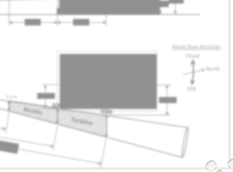
54 Study design and additions in 2014 Area viewed by mobile surveys (200 m up- and downstream of turbine) In-line with turbine NEARFIELD Stationary 24-hr surveys (31 single beam echosounder) Nearfield Beside N (DIDSON) turbine 30 m Mobile surveys (7 split beam echosounder) 15 m N 30 m 60 m ORPC TidGen ORPC TidGen Bottom
55 DOE funding started in January 2014: Interactions of aquatic animals with the ORPC OCGen in Cobscook Bay, Maine: Monitoring behavior change and assessing the probability of encounter with a deployed MHK device The goal of this project is to quantify aquatic animal behavior changes associated with the presence of a deployed marine hydrokinetic (MHK) device. Specific objectives: (i) long-term seasonal hydroacoustic dataset near an MHK device; (ii) new analytical methods to improve species identification; (iii) an encounter probability model; (iv) side-looking hydroacoustics at TidGen

; 2 = control site.")

56 (i) Long-term dataset: Month Year Jan 1, 2 Feb Mar 1, 2 1, 2 1a, 1b, 2 April May 1, 2 1a, 1b, 2 2 June 1,2 2 2 July Aug 1, 2 1a, 1b, 2 2 Sept 1, 2 1a, 1b, 2 2 Oct Nov 1, 2 Dec DEER ISLAND (CAN) CB1: Impact Site 1 = project site (a = beside turbine, b = in-line with turbine); 2 = control site. White = pre-deployment; Light grey = TidGen bottom frame deployed; Dark grey = TidGen turbine deployed. WASHINGTO N COUNTY Proposed project site Eastport CB2: Control Site Lubec
57 Seasonal patterns of relative abundance Sites different J F M A M J J A S O N D J F M A M J J A S O N D Month Project Site Control/Reference Bottom support frame deployed Turbine deployed Volume backscatter (db)


58 N Proportion of fish at different depths Control/Reference Project Bottom 15 m 1000 m 30 m ORPC TidGen
59 2014 downlooking data collection Date Site(s) OCGen Present Turbine Rotating Lunar Stage Mar 9, 2014 CB2 No NA 1st qtr; neap May 22, 2014 CB2 No NA 3rd qtr; neap Aug 5, 2014 CB1a, CB1b, CB2 Yes Yes 1st qtr; neap Aug CB1a, CB1b, CB2 Yes No 3rd qtr; neap Aug 25, 2014 CB1a, CB1b, CB2 Yes No new; spring Sep 20, 2014 CB1a, CB1b, CB2 No NA 3rd qtr; neap Nov 17, 2014 CB2 No NA 3rd qtr; neap


60 ii. New methods for improving species identification Objective: Develop db differencing methods for downlooking hydroacoustic data


61 What is in the Bay? Vieser MS thesis & data collected in species documented Over 60,000 individuals sampled (MacDonald et al. 1984, Jung and Houde 2003)
62 (iii) Encounter probability model What is the probability that a fish will encounter an MHK device? 1. Near-field within 5 m of a blade DIDSON (Viehman and Zydlewski 2014) 2. Far-field no expected effects of the device Abundance & distribution (Viehman et al. 2014) 3. Mid-field within the hydrodynamic effects, 100s m Proportion of fish at the depth of the device Farfield? Midfield Nearfield Bottom 1000 m ORPC TidGen

 and the turbine")


 8.97% (6.")
 Control site 2011")
 8.43% (7.23% - 9.")
 8.63% (6.")
 9.")
 DEER ER ISLAND")

63 Probability of fish at the depth spanned by the entire device (0-9 m) and the depth spanned by the turbine blades (6-9 m). Location Year Probability at 0-9m above seafloor Probability at 6-9m above seafloor Project site % (75.0% %) 8.32% (6.43% %) % (54.3% %) 8.97% (6.86% %) Control site % (74.6% %) 8.43% (7.23% %) % (61.5% %) 8.63% (6.73% %) % (61.4% %) 9.31% (8.11% %) DEER ER ISLAND (CAN) CB1: Impact Site Eastport CB2: Control Site Lubec WASHINGTO N COUNTY Proposed project site


64 Comparison of fish vertical distribution between project and control sites Year Month Tidal stage p-value Mar May Aug Sep Mar Ebb Flood Ebb Flood Ebb Flood Ebb Flood Ebb Flood 0.362
65 Midfield: 100s m Area viewed by mobile surveys (200 m up- and downstream of turbine) 15 m N 60 m 30 m Mobile surveys Bottom ORPC TidGen


66 Example of mobile transect Bottom support frame
67 Mobile transects Start time End time Tide No. of transects 7/29/ :00 7/29/ :30 Ebb 29 7/29/ :29 7/30/2014 1:10 Flood 27 7/30/2014 2:20 7/30/2014 7:40 Ebb 13 7/30/2014 8:50 7/30/ :45 Flood 29 7/30/ :00 7/30/ :50 Ebb 29 7/30/ :20 7/31/2014 2:05 Flood 16 7/31/2014 3:20 7/31/2014 8:00 Ebb 27 7/31/2014 9:30 7/31/ :15 Flood 28 7/31/ :20 8/1/2014 2:40 Flood 21 8/1/2014 9:50 8/1/ :13 Flood 31 8/1/ :20 8/2/2014 3:20 Flood 25 8/2/ :50 8/2/ :10 Flood 29 8/2/ :00 8/3/2014 4:00 Flood 26 8/3/ :30 8/3/ :30 Flood 26 8/13/ :10 8/14/2014 3:00 Flood 35 8/14/ :00 8/15/2014 3:00 Flood 26 8/15/ :00 8/16/ :10 Flood 27 8/15/ :00 8/16/2014 1:40 Flood 16 8/16/ :20 8/16/ :40 Flood 24


68

 In-line with turbine")
 turbine Mobile surveys (7")
")


69 (iv) Side-looking hydroacoutics at TidGen Determine sampling periodicity to represent variability over a month Area viewed by mobile surveys (200 m up- and downstream of turbine) In-line with turbine Stationary 24-hr surveys (31 single beam echosounder) Nearfield Beside (DIDSON) turbine Mobile surveys (7 split beam echosounder) Bottom 15 m N 60 m 30 m ORPC TidGen Turbine status Data collection (between gaps) Amount of side-looking acoustic data collected Operational During slack tide only 76 d, 5.8 hr Free-spinning Continuous 4 d, 0 hr Braked Continuous 33 d, 16 hr Absent Continuous 257 d, 18.4 hr (+ 59 d 22 9 hr without position data)


70
71 Temporal analysis
72 Future November control sample 2014 data analysis Most data collected in Aug/Sep is being processed Add to Long-term dataset Make correlations with trawl data db differencing Probability of encounter ELAM model Free-spinning TidGen Temporal analysis of fish presence for optimizing sampling
 17 www.")
73 OCGen Scour Monitoring Minimal horizontal movement of anchors (3-4 inches maximum) Localized scour at one corner location, maximum depth approximately 1 ft Settling of both anchors occurred to height of steel skirt (19 inches) 17

74 OCGen Retrieval 18
75 Relevance of Results Successful demonstration of OCGen module installation, anchoring and retrieval methods Opportunity to assess benthic growth on BSF, further evidence of reef effect UMaine survey of fisheries interaction contributes to knowledge base Scour monitoring indicates minimal movement of anchors 19
76 Potential Testing Opportunities ORPC s Cobscook Bay site has gained interest from other industry partners for the following reasons: Demonstrated permitting and licensing process Existing infrastructure (support structure, power and data cable, shore station) Environmental, bathymetric and resource data Experienced staff, local partners and regulators 20

77 RivGen Project Update Village of Igiugig, AK Kvichak River Deployed between August 11 and September 12, 2014 Fisheries monitoring by LGL 21 Nathan Johnson

78 RivGen Location 22

79 Fisheries Spatial Presence Smolt distribution Adult returns 23


80 Fisheries Temporal Presence 24

81 RivGen Installation 25

82 RivGen Installation 26
83 RivGen Operation 27
84 RivGen Fisheries Monitoring 28
85 RivGen Fisheries Monitoring 29

86 RivGen Fisheries Monitoring 30
87 RivGen Fisheries Monitoring 31
88 RivGen Fisheries Monitoring 32
89 RivGen Retrieval 33
90 RivGen Next Steps USDA Phase II Project 2015 demonstration in Igiugig 2016 commercial installation in Igiugig (pending AEA funding) 34
91 Technology Optimization Overview Overall goals Higher efficiency, less weight, lower production cost, increased reliability, reduced cost of electricity Seen as industry development priority within US DOE Significant re-investment in ORPC by DOE A complex effort that is national in scope: Two national laboratories (NREL and Sandia) Two universities (U. Washington and U. Alaska.) Multiple contractors (engineering, CFD, generator design, power electronics) In addition to technology improvement, DOE requires data regarding cost breakdown structure and long-term cost of energy Results will inform industry growth internationally In-water work in Alaska benefits Cobscook Bay efforts and visa versa 35
92 Technology Optimization Summary Project Focus Advanced Forward Controls Power Take Off Fairing and foil design, support structure and testing Goal Cost Funding Source Partners End Date Optimize energy harvesting capability Next generation driveline, bearings couplings, generator Ability to harness slower moving current $2.2 m US DOE: $1.7m Cost share: $475K $3.8m US DOE: $2.8m Cost share: $928K $1.55m USDA SBIR Phase I: $100K Phase II: $450 K MTI:$1m U of Wash NREL U of Alaska Aero Craft RCT Systems NREL BluSource Energy Marsh Creek Aero Craft Sandia Nat l Lab Dec Jan March,

93 Technology Optimization Progress Proposals submitted 2015 Funding awarded Contracts signed Projects commence Models developed Design and cost parameters defined Initial advanced controls field work completed Designs finalized 2016 Additional field work completed Power systems ready for commercial sale and a return to Cobscook Bay 37
94 Temporary Variance Request FERC order issued on October 29 after the following: ORPC memo to AMT on August 21, 2013 Discussion at AMT meeting on September 10, 2013 ORPC submittal to FERC on September 19, 2013 ORPC provided project updates on May 22 and September 31, Based on temporary optimization phase and continued monitoring in 2014 ORPC is requesting an extension to the variance 38 Nathan Johnson
95 Temporary Variance Request ORPC s request takes into account the following: Comprehensive pre-deployment and post-deployment environmental studies have contributed to an understanding of inter-annual variability Results-to-date indicating negligible effects to marine life for ongoing operations TGU operational status makes adherence to license condition impractical and will not advance the conditions purpose No undue impacts or impedance of other license requirements are anticipated ORPC plans to return to adherence of condition once TGU operation recommences 39 Nathan Johnson
96 Temporary Variance Request Request process: ORPC is presenting request at October 15 Adaptive Management Team AMT concurrence will be sought following meeting discussion Extension request, with support from the AMT, will be submitted to FERC 40 Nathan Johnson
97 Western Passage Update ORPC, with support from local stakeholders, requested a successive preliminary permit on January 1, 2014 FERC order denying application issued on July 2, 2014, citing lack of extraordinary circumstances ORPC has developed a strategy to continue developing the Western Passage site 41
98 ORPC Priorities TidGen Optimization RivGen Commercialization Project Western Passage permitting ORPC Solutions Governor s Energy Office Hydropower Study Wave energy project Feasibility studies 42 John Ferland
99 Action Items and Assignments ORPC will generate meeting minutes and distribute for review AMT concurrence and/or questions regarding pilot license extension AMT concurrence and/or questions on the temporary variance extension Notice of new address: 66 Pearl St, Portland 43 Nathan Johnson

100 44 Thank you from the ORPC Team! For more information: Nathan Johnson Director of Environmental Affairs visit
101 Appendix C Nemeth, M. J., Priest, J.T. & Patterson, H.M Assessment of fish and wildlife presence near two river instream energy conversion devices in the Kvichak River, Alaska in 2014.
102 Assessment of fish and wildlife presence near two river instream energy conversion devices in the Kvichak River, Alaska in 2014 Prepared for Gray Stassel Engineering, Inc. P. O. Box , Anchorage, Alaska December 2014
103

104 Assessment of fish and wildlife presence near two river instream energy conversion devices in the Kvichak River, Alaska in 2014 by Matthew J. Nemeth, Justin T. Priest, and Heather M. Patterson LGL Alaska Research Associates, Inc W. International Airport Road, Suite C1 Anchorage, Alaska for Gray Stassel Engineering, Inc. P. O. Box , Anchorage, Alaska December 2014
105 Suggested format for citation: Nemeth, M. J., J. T. Priest, and H. M. Patterson Assessment of fish and wildlife presence near two river instream energy conversion devices in the Kvichak River, Alaska in Final report prepared by LGL Alaska Research Associates, Inc., Anchorage, AK, for Gray Stassel Engineering, Anchorage, AK. 28 pp. + appendices.
106 Monitoring of Kvichak River hydrokinetic devices in 2014 EXECUTIVE SUMMARY Two river instream hydrokinetic (RISEC) devices were installed in the Kvichak River, Alaska in 2014 to demonstrate the ability to generate hydroelectric power. Fish and wildlife were monitored nearby to describe their presence and to document any negative effects from the devices. Fish were monitored using underwater video cameras and lights mounted to each device; wildlife (birds and mammals) were monitored using shore-based surveys by trained biologists and technicians. Both devices were installed near the village of Igiugig, submerged in the river until sitting on the river bottom, and operated intermittently in August and September. Fish were present at each device and were seen travelling upstream, travelling downstream, and milling. Most observed fish were salmon and salmonids (Oncorhynchus spp.) and moved freely around each device. No fish were detected moving through the turbine part of the larger device, which was manufactured by the Ocean Renewable Power Corporation. At the smaller device, manufactured by Boschma Research, Inc., one lamprey (Lampetra spp.) was detected moving downstream through the part of the device housing the turbine. Overall, salmon were clearly less abundant at the devices than along the edges of the river nearby and showed no negative effects from the devices. Wildlife consisted almost entirely of birds, had no contact with or negative effects from the devices, and showed no behavioral changes when nearby. The fish monitoring design was also meant to test the ability to use underwater cameras to monitor fish in the type of conditions found on the Kvichak River. Cameras were able to detect fish from 10 to 15 feet away, depending on water clarity; this range allowed coverage of 1/3 of the ORPC device and of the entire entrance and exit of the BRI device. In the daytime, ambient light was sufficient for fish detection; at night, lights placed nearby allowed video recording to continue with no loss of effectiveness. All cameras and lights were fixed directly to the devices in a design finalized once on site, and were powered from shore. Cameras and lights were able to be started within 1 to 12 hours after deployment of each device, and operated effectively thereafter with no breakdowns. Camera images were recorded on shore at a temporary recording station, where footage could be viewed in real time during daily site visits by trained technicians. Imagery was then transferred to a laptop computer and reviewed nearby in Igiugig. A subsample of 10 minutes was reviewed from each hour of video footage (from each camera); most of these 10-minute blocks were able to be reviewed within two days of original recording. Video imagery was recorded during all operation time by the ORPC device and 72% of the operating time by the BRI device. Overall, fish were seen at rates of less than one fish per 10-minute block of video reviewed at each device. This rate was likely a function of the device placement (relatively far offshore, in water that was deeper and faster than other parts of the river channel), and timing (after the peaks of both the juvenile and adult sockeye salmon [O. nerka] run). More detailed aspects of fish presence and behavior are reported below. v
107 Monitoring of Kvichak River hydrokinetic devices in 2014 TABLE OF CONTENTS EXECUTIVE SUMMARY...v TABLE OF CONTENTS... vi LIST OF TABLES... vii LIST OF FIGURES... vii LIST OF PHOTOS... vii LIST OF APPENDICES... viii INTRODUCTION...1 OBJECTIVES...1 STUDY AREA...1 Kvichak River Landscape and Fish Resources...1 Study Site Characteristics...2 METHODS...3 Fish Monitoring...3 Video system design...3 Data collection and management...3 Visual verification of camera imagery and signs of streambed scour...4 Wildlife monitoring...4 RESULTS...5 ORPC device...5 Operations...5 Imagery collection and review effort...6 Fish detections...6 Fish behavior...7 BRI device...7 Operations...7 Imagery collection and review effort...7 Fish Detections...8 Fish Behavior...8 Visual verification of camera results, and indications of scour...8 Wildlife monitoring both devices...9 DISCUSSION...9 Presence of fish and wildlife near the devices...9 Equipment operation...10 CONCLUSION AND RECOMMENDATIONS...11 ACKNOWLEDGEMENTS...11 LITERATURE CITED...13 TABLES...14 FIGURES...19 PHOTOS...25 APPENDIX A SAMPLE VIDEO IMAGERY...29 APPENDIX B 2014 PROGRESS REPORTS...31 vi
108 Monitoring of Kvichak River hydrokinetic devices in 2014 LIST OF TABLES Table 1. List of fish species known or suspected to use the Kvichak River near site of this study Table 2. Image recording, review effort, and total fish detections by device and operational status in Table 3. Fish species detected by device and operational status in Table 4. Fish behavior by species for each device in Table 5. Number of wildlife sightings (number of individuals) by taxonomic group in 2014, across all wildlife surveys Table 6. Movement behavior of wildlife in areas closest to devices LIST OF FIGURES Figure 1. Map of the Kvichak River in southwestern Alaska, showing locations of the hydrokinetic devices built by ORPC and BRI and operated near the village of Igiugig in Figure 2. Approximate teamporal peaks in fish presence, by species, in the Kvichak River near Igiugig relative to the 2014 monitoring period of August 13 September 10) Figure 3. Schematic of ORPC device once submerged, showing final location of cameras and lights along the port side pontoon of the device Figure 4. Schematic of BRI device once submerged, showing final location of cameras and lights Figure 5. Fish detections by hour of the day, standardized for review effort LIST OF PHOTOS Photo 1. ORPC device before deployment, showing approximate mounting locations of underwater cameras (C1 C5) and lights (L1 L2) in Photo 2. BRI device before deployment, showing mounting locations of underwater cameras and light used during deployment in Photo 3. Surface view of the BRI device while submerged on September 1, vii
109 Monitoring of Kvichak River hydrokinetic devices in 2014 Photo 4. Surface view of the BRI device at night while submerged on August 30, 2014 at 11:00 pm Photo 5. Surface view of pre-deployment testing of the underwater lights at 1:00 AM on July 3, Photo 6. Shoreside cabinetry that housed the video recording system and power link for the BRI device in LIST OF APPENDICES Appendix A. Sample Video Imagery Available for Distribution A1. Sockeye salmon video clip during pre-deployment testing of underwater lights, 7/3/2014. Video taken from above the water surface using a conventional camera A2. Coho salmon video clip from ORPC device, 8/21/ A3. Chum salmonvideo clip from ORPC device, 8/25/ A4. Pink salmon video clip from ORPC device, 8/21/ Appendix B Progress Reports Filed During the Monitoring Study B1 Inseason Update #1, July 10 th B2 Inseason Update #2, August 5 th B3 Season Summary, September 30 th viii
110 Monitoring of Kvichak River hydrokinetic devices in 2014 INTRODUCTION Two river instream conversion (RISEC) devices were operated underwater on the Kvichak River, near the village of Igiugig, Alaska, during a demonstration period in The ultimate goal of the demonstration was to test the efficiency and feasibility of the devices and gather information in preparation for a 5-year pilot license application to be submitted to the Federal Energy Regulatory Commission (FERC). Permission to operate the devices in 2014 required a Fish Habitat Permit (a Title 16 permit) from the State of Alaska, Department of Fish and Game (ADF&G), granting permission for project activities in anadromous streams (AS ). For the Title 16 permit, a monitoring plan (LGL 2014) was developed in consultation with ADF&G before deployment, to monitor fish and protect their passage. Although fish were the focus of the monitoring plan, terrestrial and aquatic wildlife were also monitored near the devices. This report describes monitoring efforts used to fulfil these requirements, including methods, fish and wildlife detections, and any detected effects (positive, negative, indifferent) on fish or wildlife from the devices. Results presented here are intended to also help refine future monitoring methods and passage protection needed during any subsequent licensing phases. The two RISEC devices monitored in 2014 were the RivGEN Power System manufactured by the Ocean Renewable Power Company (ORPC; Portland ME) and the BRI Cyclo-Turbine manufactured by Boschma Research Inc. (BRI; Brownsboro AL). Detailed designs for both devices were presented in the preseason monitoring plan (LGL 2014). OBJECTIVES The overall goal of this study was to monitor fish and wildlife in the vicinity of the RISEC devices while assessing the viability of an underwater camera system to monitor fish. The specific objectives in 2014 were as follows: 1. Document and classify any encounters of fish and wildlife with two RISEC devices. 2. Describe behavioral responses to any encounters with the devices, as well as subsequent effects on any fish or wildlife. 3. Assess whether the devices visibly alter in-stream habitat nearby. 4. Evaluate the viability of an underwater camera system to monitor fish at the devices. STUDY AREA Kvichak River Landscape and Fish Resources This project was located on the Kvichak River, near the outlet of Iliamna Lake at the village of Igiugig. The watershed flows from glacially-turbid headwater streams down 1
111 Monitoring of Kvichak River hydrokinetic devices in 2014 into Lake Clark, then southwesterly down the Newhalen River and into Iliamna Lake, the largest lake in Alaska. The Kvichak River then drains Iliamna Lake, running 106 km to the west and emptying into Bristol Bay in southwestern Alaska (Figure 1). The entire drainage is thus large (16,830 km 2 ) and is characterized by two large lakes that support enormous runs of sockeye salmon (Oncorhynchus nerka) that drive much of the region s economy. These lakes help trap glacial sediment, allowing the Kvichak River to be a relatively clearwater stream at Igiugig. Mean annual water discharge ( ) for the Kvichak River near Igiugig was 503 m 3 /s (17,763 ft 3 /s), with annual peaks in August, September, and October (USGS 2008). The Kvichak River is one of nine main rivers producing sockeye salmon targeted in Bristol Bay commercial, subsistence, and sport fisheries. Sockeye salmon return to the Kvichak River at Igiugig from mid-june to mid-july (Figure 2). The area near the RISEC demonstration sites in 2014 is important for managing the sockeye salmon fishery; part of ADF&G s inseason management of the Kvichak sockeye salmon stock comes from data collected at the salmon counting tower located just downstream of the village of Igiugig (~2 km). The average annual count of sockeye salmon at this tower was 3 million fish from 2005 through 2014 (calculated from annual count data provided by ADF&G). The Kvichak River at Igiugig is classified as Essential Fish Habitat (EFH) for anadromous fish by NOAA (2011). The Kvichak River also supports a variety of other fish species of important socioeconomic value, with habitat use that ranges from seasonal migration corridors to year-round presence (Table 1). In addition to the other four species of Pacific salmon (O. spp.) found in Alaska, these include seven non-salmon species that Krieg (2003) estimated to be harvested by at least 25% of the households in the village of Igiugig. Overall, the study area is one in which a rich assemblage of fish species results in high subsistence, sport, commercial, and socioeconomic importance to local and regional residents. Study Site Characteristics Both RISEC devices were anchored and submerged on the bottom of the river, at or near 2 of the 11 sites originally surveyed by Terrasond (2011) to determine suitability. The ORPC device was located between Sites 9 and 10, approximately 1,000 m downstream of the public boat launch at the village of Igiugig and 125 m downstream of the end of Flat Island (Figure 1). Estimated water depth was 5.8 m, water velocity was 1.5 to 2.5 m/s, and river bed substrate was small cobble with very coarse, coarse, and medium gravel, and no significant amounts of finer material (TerraSond 2011). Final placement was approximately 100 m off the west bank (river right when facing downstream). The top of the device was approximately 1.25 m below the surface of the water during deployment in 2014 (R. Tyler, ORPC, personal communication). The BRI device was installed at Site 6, approximately 100 m upstream from the boat launch and 1 km upstream from the ORPC device (Figure 1). Estimated water depth was 3 m, velocity was 1.8 to 2.5 m/s, and river bed substrate was primarily small cobble and coarse gravel with a small proportion of fines (TerraSond 2011). Final placement was 2
112 Monitoring of Kvichak River hydrokinetic devices in 2014 approximately 75 m off the south bank (river left, facing downstream) with a substrate mix that included some large cobbles (personal observation by report author MJN) in addition to the substrate documented by Terrasond in Based on water depth (3 m) minus device height (2 m), the top of the device sat approximately 1 m underwater when resting on the river bottom. Other hydraulic and bathymetric characteristics of the Kvichak River at Igiugig were described by TerraSond (2011). METHODS Fish Monitoring Fish presence near each device was monitored using underwater video cameras that recorded and stored imagery. Video recordings were reviewed to document the following events, if any: 1. The number of fish, by species, encountering the device. 2. The basic behavioral response of fish encountering the devices (e.g., attraction, avoidance, change of course). 3. Any direct contact of fish with the device turbines. 4. Any visible evidence of negative effects from a contact event, such as physical exertion, injury, or death. Video system design Underwater cameras used at the RISEC devices were powered from shore, where data was also then collected and stored in a digital video recorder (DVR) for analysis. Underwater lights were placed near some cameras to illuminate the area and collect video images at night. All cameras and lights were manufactured by IAS systems (North Vancouver, British Columbia). Cameras were customized SeeMate color to monochrome units with a F2.9 wide angle lense. Lights were SeeBrite omnidirectional model 24L-SS-LED-350. Each light had four circuit boards, each with 24 light-emitting diodes (LEDs). DVRs were 16-channel units with a frame rate of 480 pps, manufactured by Dedicated Micros (Chantilly, WA). Five cameras and two lights were used to monitor the ORPC device (Figure 3; Photo 1). Two cameras and one light were used to monitor the BRI device (Figure 4; Photo 2) Cameras and lights were affixed directly to the devices. Data collection and management Underwater cameras were operated whenever the device was operating (i.e., the turbine was spinning), as well as other times when the device was installed but not operating (i.e., the turbine was not spinning). Lights were used on a portion of the nights that the device operated. Each day, a field biologist downloaded video imagery from the shoreside power station. For review, video imagery was separated into one-hour blocks of data. Imagery was then reviewed for the first 10 minutes of each hour, from each camera. Imagery was 3
113 Monitoring of Kvichak River hydrokinetic devices in 2014 subsampled from all hours when the devices were operating, as well as a portion of the time when the device was not operating. Most subsamples of the imagery were reviewed inseason, on site in Igiugig, to detect any undesirable effects of the devices on fish (as specified in the Adaptive Management portion of the Monitoring Plan filed with the permitting process; LGL 2014). Any fish detected were classified by species or group (e.g., salmonids), and placed into one of the three size classes: small fish less than 125 mm long (corresponding to the size of juvenile salmon); medium fish mm long (smaller than adult salmon); and large fish longer than 250 mm (the size of large adult trout and adult salmon). Thereafter, all detections were classified as follows: 1. Movement direction (downstream, upstream, milling, or undetermined); 2. Evidence of passage delay, i.e., fish struggling to pass the device; 3. Contact with the device; 4. Evidence of injury or mortality; and, 5. Any other negative impacts. Additionally, reviewers described each fish detection event for follow-up analyses. Datasheets and then electronic entries were reviewed for quality assurance/control (QA/QC). Video imagery was archived on hard drives. Visual verification of camera imagery and signs of streambed scour The original monitoring also called for an alternate method to verify imagery seen by the cameras, and to report any signs of streambed scour downstream of the devices. This alternate method was to be developed in situ, based on site characteristics (LGL 2014). At the ORPC device, the safest and most reliable alternate method identified once on site was to use sonar buoy-based video footage collected by the University of Washington as part of a separate study of the device. These drifts consisted of multiple drifts that started upstream of the device and ended downstream, with a surface-mounted video camera pointed vertically towards the streambed. This footage was collected independently of and concurrent to the fish monitoring study, and provided postseason by the University of Washington (Dr. Brian Polagye). At the BRI device, Camera 2 had a view of the substrate for the first 3-5 m downstream of the device. Wildlife monitoring Visual surveys for wildlife were conducted from shore each day the devices were operational. At each device, an observation site was chosen nearby based on proximity to the device, the field of view, and access. The surrounding riverbanks, islands, and stretches of water were divided into zones delineated by natural landmarks, and enabled the technicians to place animal sightings into specific areas that were consistent through the season. 4
114 Monitoring of Kvichak River hydrokinetic devices in 2014 Each wildlife survey was for 10 minutes. During the survey, the technician continuously scanned the zones both by eye and with the aid of Fujinon 7x50 binoculars. At the beginning of each survey, the observer noted the following: time, date, presence and operational status of the RISEC device, percent cloud cover, wind speed, rain, any potential visual impediments (e.g. glare, smoke, fog), and any other operations being conducted (e.g., sonar surveys, maintenance of RISEC device). Each 10-minute survey was preceded by a 5-minute calming period to offset any unintentional disturbance of wildlife by the observers as they arrived; this 5-minute period was not an official part of the survey. For each bird and mammal sighting, the following were recorded: Species, or group if the species was not apparent. Count (noting juveniles, if present) Sighting cue (audio or visual) Location area / zone Habitat type (Air, Water, Vegetation, Ground) Movement relative to device (Towards, Away, Neutral) Reactions to device presence (e.g., looking at the device, changing course, splits in groups, changes in behavior) Interactions with the device (e.g., landing on the device itself, circling the device either on the water or in the air) Comments Each sighting was also categorized by whether the animals arrived at the survey area, left the survey area, transited through the survey area, or remained in the survey area throughout the survey. RESULTS Camera, lights, and recording equipment were tested prior to deployment (Photo 5). Once deployed, the equipment functioned reliably, with no breakdowns of camera gear or lighting. Inseason progress reports were delivered on July 10 and August 5, and a season summary was delivered September 30 (Appendix B). Final effort and results are summarized by device, below. ORPC device Operations The ORPC device was deployed on the river bottom on August 13, 2014 at approximately 1600, with the turbine starting to operate (spin) shortly thereafter. The turbine operated intermittently until September 10; the device was removed from the river on September 13. Camera operations matched the turbine schedule, operating intermittently from August 13 at 17:43 through September 10 at 15:00. 5
115 Monitoring of Kvichak River hydrokinetic devices in 2014 The five cameras and two lights all operated as planned. Video was recorded during all 87 hourly blocks when the turbine was operating. Lights were operated during most hours of nights when the device was operating. Visibility was consistent across cameras: reviewers could see an estimated ft from each camera, based on background markings, with good resolution. Water was more turbid after rain events, and turbidity increases noticeable to the human eye at the water surface were also noticeable on imagery from the cameras at the river bottom. The downstream view on Camera 5 was most difficult to review for fish because there was little contrast in the background view; the other four cameras had partial views of the device structure, which provided contrast that helped discern fish during video review. Imagery collection and review effort The device was operated intermittently on all or parts of 17 days from August 14 through September 10. We separated the 696 potential hours during this time into the following four categories (Table 2): 1. Group A: 87 hours while the device was submerged and operating. We recorded all 87 of these hours, then reviewed the 83 (95%) for which water visibility was acceptable. Across all five cameras combined, this totaled 415 hours of coverage. 2. Group B: 471 hours while the device was submerged but not operating. We recorded 117 of these hours, then reviewed 28 of them (24%), which totaled 140 hours combined among all five cameras. 3. Group C: 55 hours while the device was on the surface and not operating. We recorded none of these hours. 4. Group D: 83 miscellaneous hours while the device was submerged and either operating briefly or not at all. We recorded and archived all 83 of these hours, and reviewed none. In total, 10-minute subsamples were thus reviewed from 111 hourly blocks of data per camera, or 555 hours for all cameras combined (Table 2). Exactly 75% of these were while the device was submerged and operating. These represented 95% of the time the device operated. Fish detections Fish were detected on 32 separate events, representing 52 fish. Fish detection events were spread over 9 days; the most were on August 22, with 12 events representing 31 fish (pink salmon, chum salmon, and coho salmon; O. gorbuscha, O. keta, and O. kisutch; Table 3). The 52 fish detected consisted of 32 pink salmon, 2 chum salmon, 2 coho salmon, 14 fish of uncertain species, and 2 events that may not have even been fish. Uncertain species were usually juvenile-sized salmonids or adult-sized fish that were hard to distinguish between salmon and trout. 80% of sightings were at Camera 1. After standardizing for effort, sightings translated to 0.09 fish per hourly block at the device (52 fish divided by 555 hourly blocks among all cameras combined; Table 2). Sightings peaked between 1600 and 1800, accounting for over half of the sighting rate (Figure 5). 6
116 Monitoring of Kvichak River hydrokinetic devices in 2014 Fish behavior All behavior by live fish was milling, or traveling up- or downstream (Table 4). Milling was the most common behavior and was a mix of movements. A typical view was for the fish to drift down from above, or to emerge from the substrate along the pontoon. Many pink salmon showed this behavior. Dead fish drifted with the current and were easily differentiated from live fish. Direct, sustained movement upstream or downstream was less frequent than milling behavior. A group of four pink salmon moved upstream (Camera 1) on Aug 22. These fish were not detected on the other cameras. Four fish, all of which were pink salmon, were detected moving downstream. All of these were seen upstream of the turbine; two were dead or torpid, one was unknown, and one was a pink salmon that appeared to move downstream and over the device. Several fish were seen on Cameras 4 and 5, downstream of the turbine; these were all three of the coho or potential coho salmon seen, and all were classified as milling. There were no detections of fish contact with the turbine itself and no evidence of passage delay (while the device was operational or not). A few fish appeared to use the pontoon eddy as a velocity shelter, but not the turbine structure. Qualitatively, there was no evidence of device status (turbine spinning vs. stationary) or diel timing (day vs. night) on fish presence; sample sizes were too small to compare quantitatively. BRI device Operations The BRI CycloTurbine was installed on August 29, 2014 at 21:30. The turbine operated from this time until August 31 at 20:30. Cameras operated from August 30 at 0900 through September 2 at 10:25, thereby recording images both while the turbine operated and after it had stopped. The device stopped before a light could be installed; therefore, no imagery was collected at night. The downstream view from Camera 1 was better at night (with the light) than during the day. The reflection of the aluminum, sometimes coupled with direct sunlight, reduced image quality at times. Camera 2 was better for viewing because it had less reflective glare and because it viewed fish in cross section (i.e., looking laterally across river). Imagery collection and review effort The device was operated intermittently on all or parts of four days from August 29 September 5. The 86 potential hours during this time were separated into the following two categories (Table 2): 1. Group A: 47 hours while the device was submerged and operating. We recorded 34 of these hours, and reviewed 10-minute subsamples from all of them. Across both cameras, this totaled 68 hourly blocks reviewed. 2. Group B: 39 hours while the device was submerged but not operating. We recorded all 39 of these hours and reviewed none of them. 7
117 Monitoring of Kvichak River hydrokinetic devices in 2014 In total, 10-minute subsamples were thus reviewed from 34 hourly blocks of data per camera (from 68 hourly blocks total), all of which were while the device was submerged and operating. These represented 72% (34 of 47) of the time the device operated (Table 2). Fish Detections Fish were detected fish during 48 separate events, totaling 53 fish. These sightings were 19 pink salmon, two chum salmon, five sockeye salmon, two lamprey, and 25 unspeciated salmonids (likely whitefish or trout; Table 3). All but four of the fish detected were at Camera 2 (the downstream camera). Fish at the BRI site were spread more evenly throughout the day than at the ORPC site. Despite the relatively short deployment time, fish were seen every hour from After standardizing for effort, sightings translated to 0.78 fish per hour of review time at the device (53 fish seen over 68 hours; Table 2); no single hour accounted for more than 15% of this sighting rate (Figure 5). Fish Behavior All fish detected on Camera 2 were milling (30 fish) or moving upstream (18 fish; Table 4). A typical milling behavior was fish appearing downstream of the device and holding downstream of the device, before moving sideways and/or downstream. The fish were usually an unidentified species of salmonid. A typical upstream behavior was for fish to approach the device, hold briefly, and then move upstream and around or to swim under the downstream edge of the device. We saw no adverse effects on these fish, most of which were pink salmon. The four fish seen on Camera 1 were all traveling downstream. Four pink salmon migrated around the BRI device, one lamprey migrated above it, and one lamprey moved downstream through the device. This fish entered the device from the top, on the downstream portion of the debris guard; either the guard had broken here, or the sinuous body shape of the lamprey allowed it to pass through the guard s barrier cables. This fish presumably moved through the device and could have had contact with the turbine. Further effects on the fish could not be evaluated because the event was at night (0500 hrs), before a light had been installed on the downstream end of the device. Visual verification of camera results, and indications of scour The buoy-based video footage from University of Washington came from camera drifts over the ORPC device multiple times from August 21 through August 24. Each drift lasted approximately three to five minutes. Imagery was reviewed footage from all drifts; no fish were seen within the field of view of our fixed underwater cameras, either because no fish were there during drifts, or because it was at the limit of the drifted camera s range. The drifted camera was able to see fish elsewhere (water depth approximately 6 8 feet), and was able to see the turbine and some substrate at the device (approximately 20 feet deep); without further assessment of this camera, however, it can t 8
118 Monitoring of Kvichak River hydrokinetic devices in 2014 be known whether the absence of fish was a true negative. This footage also showed no indication of gravel disturbance or other forms of scour downstream of the device. At the BRI device, Camera 2 had an effective view of the substrate for 3 5 m downstream of the device and showed no signs of scour. The short operation time (Aug 29 Aug 31) prevented using any secondary methods to view fish. Wildlife monitoring both devices A total of 28 wildlife surveys were conducted from August 15 through September 10; of these, 25 were at the ORPC site and 3 were at the BRI site. No animals came into physical contact with, interacted with, or otherwise reacted to either device. No animals exhibited changes in behavior or course of travel while in close proximity (within 30 m) of a device. There were a total of 68 sightings of 151 individual animals. The sole mammal sighting was of a red squirrel (Tamiasciurus hudsonicus). All other sightings were of birds, the majority of which were gulls (Table 5). Most bird sightings consisted of individuals or groups flying over the river corridor; the remaining were birds that landed in view during the survey, or that were already in view at the time of the survey (Table 6). DISCUSSION Presence of fish and wildlife near the devices There was no evidence of effects on fish and wildlife at the ORPC device during the deployment period of August 13 to September 10. Notably, there were no sightings of birds swimming or diving at the device; only three groups were seen within viewing distance during the 25 surveys at this site. Fish encountered the device at low levels through the period, mostly holding near the pontoons upstream of the turbine; no fish were seen entering the turbine, and only one appeared to pass over (an adult salmon, moving downstream). Although there was space for fish to migrate underneath the turbine, we did not see this. Most sightings were adult-sized salmonids. Smaller fish would have been harder to see but still detectable within five feet, so their relative scarcity in the camera views was at least somewhat representative. There was also no evidence of effects on wildlife at the BRI device, but observed higher rates (fish/hr) than at the ORPC site (with the caveat of a shorter sampling period). The most notable fish behavior was migration of pink salmon upstream and around the device; these fish thus showed some avoidance behavior, but the device did not appear to hinder fish passage and fish did not move upstream into the device. Fish also appeared to use the device as a velocity shelter, holding and milling slightly downstream of the device. The two pink salmon seen moving downstream both went around the device, perhaps due to the fish guard. One lamprey went through both the guard and the device; unfortunately, a light had not yet been installed downstream and the status of this fish could not be assessed when it exited the device. 9
119 Monitoring of Kvichak River hydrokinetic devices in 2014 The placement of the both devices ~ 100 m from shore may have helped reduce salmon presence by putting them outside of the main migration corridor of salmon. Differences in physical conditions between the study sites may have also helped contribute to differences in fish presence between the devices. Anecdotal evidence from ADF&G (R. Regnart, personal communication), supported by field observations during this project, is that most sockeye salmon migrate within 30 feet of each river bank, and approximately 60 70% of the run migrates up the left bank. Assuming this is also representative of pink salmon (weaker swimmers than sockeye salmon), both devices may have been out of the main migration corridor of the two most abundant salmon species. Although the peak of the run had passed, many salmon were still being seen along the shoreline through August by project biologists, in densities that were (qualitatively) higher than seen on the cameras at the devices. The ORPC site was also high energy relative to the rest of the river cross section, which had eddies and much slower water velocities near each bank. These environmental conditions meant that fish had easier migration corridors further away from the device, and may have helped further reduce fish presence at the device. Although the design of the ORPC device would have also allowed fish to pass unobstructed below the turbine, no fish were seen doing so. Wildlife sightings consisted almost entirely of birds, none of which showed a behavioral response (attraction or avoidance) to the device. Equipment operation There was a demonstration component to the fish monitoring portion of this project, given that it was the first such design used to monitor these types of devices in Alaska. The equipment operated effectively, with no breakdowns of gear once it passed shoreside testing. The specifications of the two main pieces of equipment worked well together, in that the lights were able to illuminate an area exceeding the cameras effective views. Placement of lights behind the cameras worked well, with no glare problems. There were no apparent problems from vibration, such as from water current or mounting structures. One drawback to the video is that because it was designed for motion imagery, still images captured from the video are unrepresentatively poor and thus not reproduced here. Video samples are archived by the project (Appendix A) and available for distribution with this report. Water turbidity and image background influenced the ability to interpret images. The effective range (distance) also changed depending on the question asked cameras generally needed to be within 6 feet to identify juvenile salmon or speciate adult salmonids, within 10 feet to speciate adult salmon, and within 15 feet to characterize fish behavior and distinguish adult fish from debris. These distances allowed us to effectively address whether fish were entering the entire BRI device or the nearest 1/3 of the ORPC turbine, for example, but would have been less effective for differentiating behavior among trout species. Fish were more distinguishable against backgrounds with contrast (such as the ORPC turbine in the background) than without (such as with only the riverbed in the background). 10
120 Monitoring of Kvichak River hydrokinetic devices in 2014 Although the underwater imagery at the ORPC site was partial, it is likely representative for several reasons. Temporally, the subsampling approach (a ten-minute count each hour) is common for salmon in Alaska in general and on the Kvichak in particular (Anderson 2000; Reynolds et al. 2007), and should be sufficiently representative over time. Spatially, the one-third of the device visible in the cameras seems reasonably representative of the rest of it, given the uniform design of the device and the consistency of the water conditions at that site. Finally, the imagery was collected on 17 days spread across a 28-day time period, increasing the likelihood that a major change in run behavior or distribution would have been seen. The two cameras at the BRI device were able to capture % of the entry and exit. Visual verifications with a secondary method were originally intended to ground-truth the primary cameras, and meant to be developed on site once characteristics were known. The backup method chosen (camera drifted over the device as part of a separate study) was the best available option, but the need for it became reduced when the primary cameras proved to function effectively and see fish clearly. This secondary validation method should be retained in the future in case any questions develop with the main camera system. Verification surveys at the BRI device were not possible due to the short deployment time. CONCLUSION AND RECOMMENDATIONS Fish seen during the study period did not seem negatively impacted by the devices, either because of the design or the placement location (or both). When present, upstreammoving salmon were able to migrate around the devices. Downstream fish appeared able to migrate around the ORPC device on their own, and the fish guard on the BRI device appeared effective for salmonids, although perhaps less so for lamprey. The study identified a number of monitoring features to retain or adapt for future work, depending on objectives. The underwater video effectively monitored fish behavior around hydrokinetic devices on the Kvichak River, and worked for nighttime operation when paired with lights. Improvements may be needed to scale the effort up to larger sampling intervals, analyze more imagery, or refine fish identification. Depending on future objectives, some potential improvements are as follows: 1. Retain the fixed mounting system eventually selected for both cameras and lights in Replace battery banks with 110 v power. 3. Describe fish during times of higher inriver fish abundance to determine if the distribution and behavior at the devices in 2014 was representative. ACKNOWLEDGEMENTS In Igiugig, we thank the Igiugig Village Council and numerous area residents for on-site help critical to study success. Ida Nelson, AlexAnna Salmon, and Jim Tilly were 11
121 Monitoring of Kvichak River hydrokinetic devices in 2014 especially helpful. From the device makers, Monty Worthington and Ryan Tyler (ORPC) and Mike Ryder (BRI) were instrumental to on-site design, testing, and overall creative collaboration necessary for study success. Chris Sewright, Quenton Berger, Robert Kirchner, Brad Kalb, Craig Ziolkowski, and Kris Shippen (LGL) helped with design, monitoring, and analysis. Dr. Brian Polagye (University of Washington) provided additional video imagery from a separate study at the ORPC device. Project planning was a key part of this initial effort. Bill Price (Gray Stassel Engineering) led the overall permitting effort and provided important guidance to the monitoring plan and study. Alan Baldevieso and Alan Fetters (Alaska Energy Authority) provided administrative help, along with logistical boosts at key times. Jim and Judy Boschma helped with study pre-planning and administration. Guy Wade helped develop the initial monitoring plan, which was further improved by reviews by ADF&G. Funding for this fish and wildlife monitoring study was provided by the Alaska Energy Authority. 12
122 Monitoring of Kvichak River hydrokinetic devices in 2014 LITERATURE CITED Anderson, C.J Counting tower projects in the Bristol Bay area, Alaska Department of Fish and Game, Division of Commercial Fisheries, Regional Information Report 2A00-08, Anchorage. Krieg, T., M. Chythlook, P. Coiley-Kenner, D. Holen, K. Kamletz, and H. Nicholson Subsistence Fisheries Assessment: Kvichak River Watershed Resident Species. Federal Subsistence Fishery Monitoring Program, Final Project Report No. FIS U. S. Fish and Wildlife Service, Office of Subsistence Management, Fisheries Resource Monitoring Program, Fishery Information Service, Anchorage, Alaska. LGL Alaska Research Associates, Inc. (LGL) Fish and Wildlife Monitoring Plan for the Kvichak River RISEC Demonstration Project in Report prepared for Gray Stassel Engineering. May 20, 2014 Anchorage, Alaska. National Oceanic Atmospheric Administration Alaska Essential Fish Habitat (EFH) Information and Research. Retrieved on 12 October 2011 from NOAA webpage: Reynolds, J.H., C.A. Woody, N.E. Gove, and L.F. Fair Efficiently estimating salmon escapement uncertainty using systematically sampled data. Pages in C.A. Woody (editor). Evolution, ecology and management of sockeye salmon. American Fisheries Society Symposium No. 54. Bethesda, MD. TerraSond Kvichak River RISEC Project. Resource reconnaissance and physical characterization. Final Report. Prepared by TerraSond Ltd., Palmer, AK for Dept. of Community and Economic Development, AIDEA/AEA, Rural Energy Group, Anchorage, AK. USGS National Water Information System: Web Interface, Retrieved on 20 December 2008 from the United States Geological Survey webpage: GS. 13
123 Monitoring of Kvichak River hydrokinetic devices in 2014 TABLES 14
124 Monitoring of Kvichak River hydrokinetic devices in 2014 Table 1. List of fish species known or suspected to use the Kvichak River near site of this study. Subsistence use is from Krieg et al. (2003). Common name a Scientific name Subsistence Habitat use at study Seasonal timing use site b Alaskan brook lamprey Lampetra alaskense No Migrant unknown Arctic-Alaskan lamprey L. camtschatica/alaskense No Migrant unknown longnose sucker Catostomus catostomus Yes Migrant Spring northern pike Esox lucius Yes Migrant/Resident Spring/Fall Alaska blackfish Dallia pectoralis Yes non-typical year-round rainbow smelt Osmerus mordax Yes Migrant Spring/Fall broad whitefish Coregonus nasus Yes non-typical Fall humpback whitefish Coregonus pidschian Yes Migrant Fall least cisco Coregonus sardinella Yes Migrant Fall pygmy whitefish Prosopium coulteri Yes Migrant unknown round whitefish Prosopium cylindraceum Yes Migrant unknown Arctic grayling Thymallus arcticus Yes Migrant/Resident Spring/Summer/Fall pink salmon Oncorhynchus gorbuscha Yes Migrant Summer chum salmon Oncorhynchus keta Yes Migrant Summer coho salmon Oncorhynchus kisutch Yes Migrant Summer/Fall rainbow trout Oncorhynchus mykiss Yes Migrant/Seasonal Spring/Fall sockeye salmon Oncorhynchus nerka Yes Migrant Spring/Summer Chinook salmon Oncorhynchus tshawytscha Yes Migrant Summer Arctic char Salvelinus alpinus Yes Migrant/Seasonal unknown Dolly Varden Salvelinus malma Yes Migrant/Seasonal Spring/Fall lake trout Salvelinus namaycush Yes non-typical year-round burbot Lota lota Yes non-typical year-round threespine stickleback Gasterosteus aculeatus No Resident year-round ninespine stickleback Pungitius pungitius No Resident year-round slimy sculpin Cottus cognatus No Resident year-round a Alt et al a,b Mansfield 2004 b Migrant - utilize study site seasonally as a migratory corridor Fall et al Mecklenburg et al Seasonal - May reside in study site Gryska 2007 Minard et al non-typical - rarely encontered in study site Groot et al Morrow 1980 Resident - Majority of life cycle could occur in study site Hauser 2007 Quinn 2005 Hubartt 1994 Salomone et al Krieg et al Woody et al
125 Monitoring of Kvichak River hydrokinetic devices in 2014 Table 2. Image recording, review effort, and fish detections by device and operational status in Hourly blocks Review hours a Events Fish Device Status Hourly intervals Hourly blocks with video recording Hourly blocks with video review Number of cameras Total hourly blocks reviewed, all cameras combined Fish detection events Events / hourly review block No. of fish Fish / hourly review block ORPC Floating on surface Submerged, not spinning Submerged, spinning Various/Intermittent Total BRI Floating on surface Submerged, not spinning Submerged, spinning Various/Intermittent Total a Each hourly block reviewed consisted of a 10-minute subsample 16
126 Monitoring of Kvichak River hydrokinetic devices in 2014 Table 3. Fish species detected by device status and operational status in Device Device operating? Hourly blocks reviewed a Pink salmon Chum salmon No. of fish detected Coho salmon Sockeye salmon Lamprey Unidentified spp. Total ORPC Yes No BRI Yes No 0 0 Table 4. Fish behavior by species for each device in Behavior Chum salmon Coho salmon Pink salmon Unidentified Sockeye salmon Lamprey Total ORPC Drifting Milling Travel, down 4 4 Travel, up Undetermined 1 1 Subtotal, ORPC Comments 2 dead/dying pinks; 1 unidentified; 1 juv Variety of behaviors All upstream of turbine; 1 fish might go over All upstream of turbine BRI Milling Travel, down Travel, up Undetermined 1 1 Subtotal, BRI Variety of behaviors 2 pinks around; 2 lamprey go over, thru 15 went around/under Grand Total
127 Monitoring of Kvichak River hydrokinetic devices in 2014 Table 5. Total number of wildlife sightings (number of individuals) by taxonomic group seen during wildlife surveys at the hydrokinetic devices in Device status during each survey is described as Operating (submerged and rotating, n=16), Not Operating (submerged and not rotating, n=10), or At Surface (not submerged and not rotating, n=2). Taxonomic Group Device Status Operating Not Operating At Surface Total Small Mammals (1) 1 (1) Waterfowl 0 4 (24) 0 4 (24) Bald Eagle 2 (2) (2) Other Raptors 0 1 (1) 0 1 (1) Shorebirds 1 (1) 1 (7) 0 2 (8) Gulls 30 (56) 1 (28) 4 (4) 35 (88) Corvids 2 (2) 2 (2) 1 (1) 5 (5) Passerines 12 (14) 3 (4) 3 (4) 18 (22) Total Birds 47 (75) 12 (66) 8 (9) 67 (150) Table 6. Movement behavior by number of sightings (number of individuals) for the wildlife in areas nearest (~ 200 m) the hydrokinetic devices in Movements categorized as Arrived (animal entered area during sighting), Departed (animal exited area during sighting), Remained (animal stayed within area throughout the duration of the sighting), Transited (animal entered and exited area during sighting), and Unknown (unable to determine, applies to animals detected by audio cue). Data excludes the 5- minute calming period before each survey. Taxonomic Group Movement of Animals in Areas Nearest Device Arrived Departed Remained Transited Unknown Total Small Mammals (1) 1 (1) Waterfowl (5) 0 1 (5) Bald Eagle Other Raptors 1 (1) (1) Shorebirds (8) 0 2 (8) Gulls 1 (2) (40) 0 18 (42) Corvids 1 (1) (1) 1 (1) 3 (3) Passerines 0 3 (3) 4 (6) 1 (1) 2 (2) 10 (12) Total Birds 3 (4) 3 (3) 4 (6) 22 (55) 3 (3) 36 (72) Areas not recorded for surveys
128 Monitoring of Kvichak River hydrokinetic devices in 2014 FIGURES 19

129 Monitoring of Kvichak River hydrokinetic devices in 2014 Figure 1. Map of the Kvichak River in southwestern Alaska, showing locations of the hydrokinetic devices built by ORPC and BRI and operated near the village of Igiugig in
130 Monitoring of Kvichak River hydrokinetic devices in 2014 Migrant Resident Calendar Year Kvichak River Fish Alaskan brook lamprey Arctic-Alaskan lamprey longnose sucker northern pike rainbow smelt broad whitefish humpback whitefish least cisco round whitefish Arctic grayling pink salmon chum salmon coho salmon rainbow trout sockeye salmon (adult) sockeye salmon (smolt) Chinook salmon Dolly Varden lake trout burbot threespine stickleback ninespine stickleback slimy sculpin January February March April May June July August September Monitoring period in 2014 October November December Figure 2. Approximate temporal peaks in fish presence, by species, in the Kvichak River near Igiugig relative to the 2014 monitoring period of August 13 September 10 (multiple sources; see Table 1).. 21
131 Monitoring of Kvichak River hydrokinetic devices in 2014 Camera 1 Light 1 Water flow Camera 2 Turbine Camera 3 Light 2 Camera 4 Camera 5 Figure 3. Schematic of ORPC device once submerged, showing final location of cameras and lights along the port side pontoon of the device. Dashed lines model the field of view from each camera. Schematic is not to scale. 22
132 Monitoring of Kvichak River hydrokinetic devices in 2014 Light 1 Debris guard Camera 1 Inlet Water flow Turbine Outlet Camera 2 Figure 4. Schematic of BRI device once submerged, showing final location of cameras and lights. Dashed lines model the field of view from each camera. Schematic is not to scale. 23
133 Monitoring of Kvichak River hydrokinetic devices in BRI Device ORPC Device Fish per hour Hour of day Figure 5. Fish detections by hour of the day at each RISEC device, standardized for review effort. 24
134 Monitoring of Kvichak River hydrokinetic devices in 2014 PHOTOS 25
 and lights (L1 L2)")

135 Monitoring of Kvichak River hydrokinetic devices in 2014 Water flow C1 L1 C2 C3 L2 C4 C5 Photo 1. ORPC device before deployment, showing approximate mount locations of underwater cameras (C1 C5) and lights (L1 L2) in Water would flow from left to right. Light 1 Camera 1 Water Camera 2 flow Photo 2. BRI device before deployment, showing mount locations of underwater cameras and light used during deployment in Water would flow from left to right. 26


136 Monitoring of Kvichak River hydrokinetic devices in 2014 Photo 3. Surface view of the BRI device while submerged on September 1, Water flowing from right to left; device is the white object visible in right center of photo. Photo 4. Surface view of the BRI device at night while submerged on August 30, 2014 at 11:00 pm. Illumination from underwater light attached to device is visible in right center of photo. Water flowing from right to left. 27

 camera, from about 20 m away. Photo 6.")
137 Monitoring of Kvichak River hydrokinetic devices in 2014 Photo 5. Surface view of pre-deployment testing of the underwater lights at 1:00 AM on July 3, Approximately ten sockeye salmon are seen migrating within the illumination field, at the top center of photo. Image is from a conventional (not underwater) camera, from about 20 m away. Photo 6. Shoreside cabinetry that housed the video recording system and power link for the BRI RISEC device in Marker buoys for the submerged device can be seen at top left of photo. 28

138 Monitoring of Kvichak River hydrokinetic devices in 2014 APPENDIX A SAMPLE VIDEO IMAGERY Video clips available for distribution upon request. A1. Sockeye salmon migrating past test site during pre-deployment testing of underwater lights, 7/3/2014. Video taken from above the water surface using a conventional camera. A2. Coho salmon video clip from the ORPC device, 8/21/
139 Monitoring of Kvichak River hydrokinetic devices in 2014 A3. Chum salmon video clip from the ORPC device, 8/25/2014. A4. Pink salmon video clip from the ORPC device 8/21/
140 Monitoring of Kvichak River hydrokinetic devices in 2014 APPENDIX B 2014 PROGRESS REPORTS Progress reports filed during the monitoring study in B1 Inseason Update #1, July 10 th 2014 B2 Inseason Update #2, August 5 th 2014 B3 Season Summary, September 30 th
141 Fish and Wildlife Monitoring of Kvichak RISEC devices In-season Progress Report # TO: Bill Price, Gray Stassel Engineering, Inc. RE: Fish & Wildlife Monitoring DATE: 7/10/14 REPORTING PERIOD: Through July 3 Prepared by: Matt Nemeth, LGL Alaska Research Associates, Inc. cc: Priest, Patterson, Funk, Cr. Ziolkowski (LGL) This report summarizes progress through July 3 rd by LGL Alaska Research Associates, Inc. (LGL) for fish and wildlife monitoring of the RISEC devices on the Kvichak River. July 3 rd marked the end of the first field trip. Overall status Neither RISEC device has been deployed, so LGL s work to date has consisted of preparation and designs. The BRI device has been outfitted with two specialized underwater cameras and one light, fastened directly to the device on fixed mounts. Once the device is ready for deployment, we will need approximately one day to make the electronics operational. The ORPC device has been outfitted with fixed mounts for six cameras and two lights. Two to three days will be needed to install the electronics on these mounts, route the cables, assemble the shoreside power bank, and deploy the cables from the device to the power bank. These steps must be coordinated with other work on the device (non-lgl), and won t be started until the device deployment schedule(s) are firmed up. Summary of field efforts through July 3 Preparation Most work in June was spent preparing for our (LGL s) June 25 departure to Igiugig. Materials needed for mounts were generally shipped unassembled, partly for logistical reasons and partly to help accelerate the potential deployment schedule. Overall, this appeared to have been the correct approach. Assembling in Igiugig helped get bulk items such as cement and steel sent earlier and more cost effectively, and gave us greater flexibility once on site and able to assess the devices in coordination with BRI and ORPC staff. The last shipment of cameras and lights was received June 27 th. Camera and light designs Upon arrival in Igiugig, we prioritized work on the BRI device to support a potential deployment as soon as June 28. One camera (BRI-1) was attached halfway along the debris guard that forms the bow (upstream end) of the device. This camera faced downstream, positioned to view fish 1
142 In-season Progress Report #1: fish and wildlife monitoring of Kvichak RISEC devices moving towards the device mouth from approximately 20 feet upstream (Figure 1). A second camera (BRI-2) was attached to the stern (downstream end) of the device at its exit. This camera faced sideways but slightly downstream, positioned to capture fish downstream of the device (moving either upstream or downstream). One light was fixed approximately 10 feet upstream of camera BRI-1 (Figure 1), and a second will be added using mobile mounts, near camera BRI- 2. One to two additional cameras will be added using mobile mounts (i.e., not attached to the device); these will be added after the device s deployment, in a way that best completes the intended fields of view described in the monitoring plan. The ORPC designs were finalized such that mounts for six cameras and two lights were attached along the port side pontoon, split evenly upstream and downstream of the turbine that spans the pontoon centreline. This arrangement seem superior to the prior, tentative plan of having only up to three cameras mounted on the pontoon. The six camera mounts (ORPC 1-6) are positioned to collectively show an approximate 180-degree field of view from the bow of the device (ORPC-1, looking sideways) to the stern of the device (ORPC-6, looking directly downstream), and should provide most of intended fields of view described in the monitoring plan. Fish moving between the bow and stern can be captured synoptically by the different cameras; the fields of view may overlap or have blind spots, depending on distance from camera. One challenge with the ORPC device is that we can t know camera performance in situ until the device is sunk, after which it can t be re-floated just to adjust cameras. Therefore, we may remove one camera (ORPC-2) beforehand and reserve it for a mobile placement after seeing how the fixed cameras perform. This camera would be used to complete the intended field of view in described in the monitoring plan. Field testing Fourth lights, nine cameras, and both DVRs tested correctly in Igiugig. The tenth camera works only in low light. A number of smaller glitches have been, or are still being, troubleshot. The full system was used successfully to identify sockeye salmon swimming near the BRI site, day and night, from a distance of 10 to 15 ft from the camera, in water 2 to 3 ft deep. Future field work Both device makers are revising their deployment schedules the week of July 7, with little work we can do on site in the interim without exposing the gear to surface damage while not being watched. We ve therefore removed our staff from Igiugig for the time being. Once the BRI device is floated onto its anchor and pulled to shore, we will inspect the electronics attached in June, deploy our cables between the shore and deployment site, and install shoreside electronics and temporary power lines at the optimal site between the device and the BRI power source. This will allow us to begin monitoring using the two fixed cameras. The two mobile cameras will then be phased in, where needed. Our cabling will be independent of BRI s. Once the ORPC schedule is determined and further float tests are complete, we will attach the cameras and lights. The device will then be floated onto its anchor and all cabling (ORPC and 2

143 In-season Progress Report #1: fish and wildlife monitoring of Kvichak RISEC devices LGL) will be run to shore. We will then install the shoreside power supply and electronics and begin monitoring. Our cabling will be independent of ORPC s. July work will be summarized in the next progress report on August 4 th. Table 1. Overview of location, view direction, and testing status of lights and cameras as of July 3. Some camera locations may be further rearranged. Gear Code Location Direction of view Tested Camera BRI-1 Starboard bow, midway up debris Down OK guard Camera BRI-2 Starboard stern, at device exit Across and down OK Camera BRI-3 Mobile TBD OK Camera TBD Mobile TBD Problems Light BRI Center, bow, upstream end Downstream OK Light BRI Mobile TBD OK Camera ORPC-1 Port side, bow, upstream Across OK Camera ORPC-2 Port side, bow, midway Across OK Camera ORPC-3 Port side, bow, near turbine Across and down OK Camera ORPC-4 Port side, stern, near turbine Across and up OK Camera ORPC-5 Port side, stern, midway Across OK Camera ORPC-6 Port side, stern, downstream Downstream OK Light ORPC Port side, bow, midway Across and down OK Light ORPC Port side, stern, midway Across and up OK Figure 1. Location of mounts for two cameras (white arrows) and one light (red oval) on the BRI device. Water would flow from left to right. 3
2015 ENVIRONMENTAL MONITORING REPORT
 < COBSCOOK BAY TIDAL ENERGY PROJECT 2015 ENVIRONMENTAL MONITORING REPORT FERC PROJECT NO. P-12711-005 March 28, 2016 ORPC Maine, LLC 66 Pearl Street, Suite 301 Portland, ME 04101 Phone (207) 772-7707 www.orpc.co
Hydrokinetic Project Development
 Hydrokinetic Project Development Presented at the Alaska Rural Energy Conference, Fairbanks, AK April 29,2010 Monty Worthington, Director of Project Development Ocean Renewable Power Company Overview Developer
Emission-Free Electricity from the World s Rivers and Seas
 Emission-Free Electricity from the World s Rivers and Seas Presentation for the: Second Annual Cobscook Bay Conference Renewable Energy in Maine Communities The Boat School on Deep Cove Road, Eastport
ORPC Alaska The Future of Tidal Energy on the Railbelt
 ORPC Alaska The Future of Tidal Energy on the Railbelt Alaska Rural Energy Conference April 28, 2010 Monty Worthington, Director of Project Development, Alaska Ocean Renewable Power Company Overview Developer
Emission-Free Electricity from the World s Rivers and Seas
 Speaker 25: 1 Emission-Free Electricity from the World s Rivers and Seas Presentation to: Law Seminars International Renewable Energy in New England Conference September 9, 2008 ORPC Overview Ocean Renewable
Marine and Hydrokinetic Energy and the FERC Regulatory Process
 Marine and Hydrokinetic Energy and the FERC Regulatory Process The views expressed in this presentation are those of the author and do not necessarily represent the views of the Commission. Federal Energy
Marine Renewable Energy Solutions for Island and Remote Communities
 Marine Renewable Energy Solutions for Island and Remote Communities Presented to The Island Institute s Island Energy Conference Belfast, Maine October 18, 2013 Nathan Johnson, Director of Environmental
Southeast National Marine Renewable Energy Center
 Conference Paper SNMREC/CP-10-125 May, 2010 Ocean Energy: Challenges and Opportunities Susan H. Skemp Offshore Technology Conference, 2010 Houston, TX Southeast National Marine Renewable Energy Center
Pilot Project Licensing Justification Statement
 Pilot Project Licensing Justification Statement The following demonstrates that the Snohomish County Public Utility District No. 1 (Snohomish) Admiralty Inlet Pilot Tidal Project (the Project ) meets the
Site Selection and Permitting For Shellfish Aquaculture Regulatory Aspects
 Site Selection and Permitting For Shellfish Aquaculture Regulatory Aspects Tessa Getchis Connecticut Sea Grant Department of Extension University of Connecticut 1 2 Getting Started Site Selection Environmental
Advancing Tidal Research Initiatives for Nova Scotia
 Issue 3 Spring 2011 Advancing Tidal Research Initiatives for Nova Scotia Cape Split on Flood Tide Photo Credit: Colin Buhariwalla, Acadia University In this issue of Currents OEER Association (OEER) is
PROGRESS REPORT. National Oceanic and Atmospheric Administration (NOAA)
") NOAA 2011 Protected Species Studies of Green Sturgeon along the West Coast of the U.S. to Guide the Design and to Implement a Monitoring Program to Track Coast-Wide Status and Trends for Future Population
NOAA 2011 Protected Species Studies of Green Sturgeon along the West Coast of the U.S. to Guide the Design and to Implement a Monitoring Program to Track Coast-Wide Status and Trends for Future Population
Tidal Hydrokinetic Energy
 Tidal Hydrokinetic Energy Brian Polagye Research Assistant Professor University of Washington September 23, 2010 Tidal Energy Challenges Northwest National Marine Renewable Energy Center Tidal Energy Barrage
BEFORE THE UNITED STATES DEPARTMENT OF DEFENSE DEPARTMENT OF THE ARMY, CORPS OF ENGINEERS
 BEFORE THE UNITED STATES DEPARTMENT OF DEFENSE DEPARTMENT OF THE ARMY, CORPS OF ENGINEERS Proposal to Reissue And ) Modify Nationwide Permits ) ZRIN 0710-ZA05 COMMENTS OF THE OCEAN RENEWABLE ENERGY COALITION
4.1.1 Best Practices for Agency Coordination
 4.1.1 Best Practices for Agency Coordination 4.1.1.1 Introduction This section describes best practices for agency coordination in the use of data and information under existing authorities, as described
Tidal Energy Exploration in Puget Sound
 Tidal Energy Exploration in Puget Sound Project Objectives Objective is to generate relevant data to better evaluate the technical, economic, and environmental feasibility of tidal energy generation. Project
FUNDY TIDAL ENERGY DEMONSTRATION PROJECT Environmental Effects Monitoring Report. APPENDIX A Environmental Impact Predictions
 FUNDY TIDAL ENERGY DEMONSTRATION PROJECT Environmental Effects Monitoring Report APPENDIX A Environmental Impact Predictions 1 Environmental Impact Predictions - Fundy Tidal Energy Demonstration Project
Offshore Wind Development in the U.S.
 Offshore Wind Development in the U.S. Dan Chorost November 2017 Roadmap U.S. Offshore Wind Resources and Development Legal Framework for OSW Development in the U.S. State-Led Initiatives: New York Litigation
Marine and Hydrokinetic Energy in Florida: Toward Implementation
 Marine and Hydrokinetic Energy in Florida: Toward Implementation Summary: Marine renewable energy is poised to become an important component of a diversified energy portfolio for the nation s future. Like
Draft Resolution: Ocean Energy
 Agenda Item 6.2.2 Further Implementation of the Agreement Conservation Issues Document 6.2.2 Draft Resolution: Action Requested Review the draft Resolution Introduce any changes as desired Adopt the Resolution
PUBLIC NOTICE NO. FP13-AB03-05 August 30, 2013 CESAM-PD-EC JOINT PUBLIC NOTICE
 DEPARTMENT OF THE ARMY MOBILE DISTRICT, CORPS OF ENGINEERS P.O. BOX 2288 MOBILE, ALABAMA 36628-0001 REPLY TO ATTENTION OF: JOINT PUBLIC NOTICE U. S. ARMY CORPS OF ENGINEERS, MOBILE DISTRICT AND FLORIDA
Request for a Proposal The Bolsa Chica Lowlands Restoration Project: Sustainability Alternatives Study January 2019
 Request for a Proposal The Bolsa Chica Lowlands Restoration Project: Sustainability Alternatives Study January 2019 Introduction The Bolsa Chica Land Trust (BCLT) has applied for and been selected to receive
Chapter 5 Regulatory Coordination and Compliance
 Chapter 5 Regulatory Coordination and Compliance This chapter provides an update on the federal, state, and local laws and regulations that required the City to coordinate with regulatory agencies to obtain
12504-SPD REGULATORY PROGRAM ESSENTIAL FISH HABITAT (EFH) PROCEDURES
 PROCEDURES") 12504-SPD REGULATORY PROGRAM ESSENTIAL FISH HABITAT (EFH) PROCEDURES South Pacific Division Table of Contents 1.0 Purpose 2.0 Applicability 3.0 References 4.0 Related Procedures 5.0 Definitions 6.0 Responsibilities
12504-SPD REGULATORY PROGRAM ESSENTIAL FISH HABITAT (EFH) PROCEDURES South Pacific Division Table of Contents 1.0 Purpose 2.0 Applicability 3.0 References 4.0 Related Procedures 5.0 Definitions 6.0 Responsibilities
Draft Supplemental Environmental Impact Statement
 Draft Supplemental Environmental Impact Statement December 2013 City of Seattle Department of Transportation 700 Fifth Avenue, Suite 3900 Seattle, WA 98124 TABLE OF CONTENTS Elliott Bay Seawall Project
Environmental Effects of Tidal Energy Outcomes of a Scientific Workshop
 Environmental Effects of Tidal Energy Outcomes of a Scientific Workshop Brian Polagye University of Washington Northwest National Marine Renewable Energy Center Boundaries: Benthic and Coastal Environments
Walk Bridge Project. Norwalk Shellfish Commission. November 1,
 Walk Bridge Project Norwalk Shellfish Commission November 1, 2018 Meeting Agenda 1. Welcome & Introductions John Hanifin, CTDOT 2. Project Update Christian Brown, HNTB Lauren DiGovanni, HNTB 3. Project
Columbia River System Operations Environmental Impact Statement Newsletter
 Summer 2017 (revised) Columbia River System Operations Environmental Impact Statement Newsletter INSIDE: CRSO EIS Columbia River System multiple uses The CRSO and integrating renewable energy Fish passage
Request for Proposals. Acoustic Survey to Determine Noise Signature at the Fundy Ocean Research Center for Energy Demonstration Site
 Request for Proposals Acoustic Survey to Determine Noise Signature at the Fundy Ocean Research Center for Energy Demonstration Site Release date: April 21, 2011 Fundy Ocean Research Center for Energy (FORCE)
Final Supplemental Environmental Impact Statement
 Final Supplemental Environmental Impact Statement April 2014 City of Seattle Department of Transportation 700 Fifth Avenue, Suite 3900 Seattle, WA 98124 TABLE OF CONTENTS Elliott Bay Seawall Project TABLE
Environmental Monitoring of Hydrokinetic Energy Projects in Alaska
 Environmental Monitoring of Hydrokinetic Energy Projects in Alaska Jeremy Kasper Alaska Hydrokinetic Energy Research Center P. Bradley, P. Duvoy, J. Johnson, N. Konefal, J. Schmid, A. Seitz July 2015 Outline
Winter 2018 Newsletter
 Winter 2018 Newsletter Florida Reef Tract Water Quality Monitoring Program David Cox, Land Based Sources of Pollution Coordinator For the 2017-18 Fiscal Year, the Florida Legislature has provided X in
Ecosystem Research Initiative (ERI) in the St. Lawrence Estuary, eastern Canada:
 in the St. Lawrence Estuary, eastern Canada:") Ecosystem Research Initiative (ERI) in the St. Lawrence Estuary, eastern Canada: Testing an approach for science support to ecosystem-based management Boulogne Sur Mer November 5-7, 2008 Outline of the
Ecosystem Research Initiative (ERI) in the St. Lawrence Estuary, eastern Canada: Testing an approach for science support to ecosystem-based management Boulogne Sur Mer November 5-7, 2008 Outline of the
Evaluating Environmental Risks of Marine and Hydrokinetic (MHK) Development
 Development") Evaluating Environmental Risks of Marine and Hydrokinetic (MHK) Development Dr. Andrea E. Copping Pacific Northwest National Laboratory CESA Webinar August 19 th 2010 1 Environmental Effects of MHK Energy
Evaluating Environmental Risks of Marine and Hydrokinetic (MHK) Development Dr. Andrea E. Copping Pacific Northwest National Laboratory CESA Webinar August 19 th 2010 1 Environmental Effects of MHK Energy
Scoping Document for the Environmental Assessment Statoil Waverley 3D Seismic Survey Exploration Licenses 2435 and 2436
 Scoping Document for the Environmental Assessment Statoil Waverley 3D Seismic Survey Exploration Licenses 2435 and 2436 September 1, 2017 Page 1 This page is intentionally left blank Table of Contents
AEA - Kodiak Electric Association Terror Lake Hydroelectric Facility Expansion
 Total Project Snapshot Report 2011 Legislature TPS Report 55977v2 Agency: Commerce, Community and Economic Development Grant Recipient: Kodiak Electric Association, Inc. Project Title: Federal Tax ID:
Engineering Research Needs & Links to Science
 Engineering Research Needs & Links to Science OEER/FORCE Tidal Energy Workshop October 14, 2010 Scientific Research to Date FORCE To achieve environmental approval Bathymetry/current data from BIO: External
THE OCEAN: THE NEXT FRONTIER IN RENEWABLE ENERGY?
 THE OCEAN: THE NEXT FRONTIER IN RENEWABLE ENERGY? A WHITE PAPER FROM ENTERPRISE FLORIDA AND GTM RESEARCH DANIEL ENGLANDER GTM RESEARCH 1 INTRODUCTION The ocean power industry is emerging as one of the
Case 2:11-cv GZS Document Filed 08/02/11 Page 1 of 8 PageID #: 259 EXHIBIT 18
 Case 2:11-cv-00276-GZS Document 19-18 Filed 08/02/11 Page 1 of 8 PageID #: 259 EXHIBIT 18 Case 2:11-cv-00276-GZS Document 19-18 Filed 08/02/11 Page 2 of 8 PageID #: 260 MILLER HYDRO GROUP 148 Middle Street
Scoping Document for the Environmental Assessment. BP Exploration (Canada) Ltd. Tangier 3D Seismic Survey
 Ltd. Tangier 3D Seismic Survey") Scoping Document for the Environmental Assessment BP Exploration (Canada) Ltd. Tangier 3D Seismic Survey Exploration Licenses 2431, 2432, 2433, and 2434 August 2013 Contents 1.0 Purpose... 2 2.0 Regulatory
Scoping Document for the Environmental Assessment BP Exploration (Canada) Ltd. Tangier 3D Seismic Survey Exploration Licenses 2431, 2432, 2433, and 2434 August 2013 Contents 1.0 Purpose... 2 2.0 Regulatory
Free Flow Power Corporation
 Large Scale Hydrokinetics in the Mississippi River Free Flow Power Corporation A new generation of energy Power Generation Renewable Energy Manufacturing Generation LSU Alternative Energy Conference April
DEPARTMENT OF THE ARMY u.s. Army Corps of Engineers 441 G Street N.w. WASHINGTON, D.C
 DEPARTMENT OF THE ARMY u.s. Army Corps of Engineers 441 G Street N.w. WASHINGTON, D.C. 20314-1000 REPLY TO ATTENTION OF: CECW-CO NO\! 2 9 2004 MEMORANDUM FOR COMMANDERS, MAJOR SUBORDINATE COMMANDS AND
Active West Coast Hydrokinetic Projects Tuesday, March 22, 2011
 Active West Coast Hydrokinetic s Tuesday, March 22, 2011 Report developed by the Pacific Fishery Management Council California P 13376 Del Mar Landing (Sonoma County Water Agency)* 7/9/2009 Study location
9. Endangered Species Act and Marine Mammal Protection Act
 9. Endangered Species Act and Marine Mammal Protection Act 9.1. Introduction 9.2. Identification of Protected Species and/or Habitat 9.3. Determinations of Effect under ESA 9.4. ESA Section 7 Consultation
Ecological Perspectives on Offshore Wave Energy Development in the Pacific Northwest: The Big Picture
 Ecological Perspectives on Offshore Wave Energy Development in the Pacific Northwest: The Big Picture The Wildlife Society, Oregon Chapter Salishan Lodge, February 10, 2009 Gregory McMurray Principal Marine
RE: Marine Mammal Incidental Harassment Authorization for Pile Placement for ORPC's Cobscook Bay Tidal Energy Pilot Project
 OR.PC OCEAN RENEWABLE POWER COMPANY Herbert C. Scribner DIRECTOR - ENVIRONMENTAL AFFAIRS 12 Exchange St., Suite 58 Portland, ME 411 DI RECT 27 221 6255 CELL 2749142 OFFICE 27 772 777 hscri bner@oceanrenewablepower.
J O I N T P U B L I C N O T I C E
 J O I N T P U B L I C N O T I C E CHARLESTON DISTRICT, CORPS OF ENGINEERS 69A Hagood Avenue Charleston, SC 2943-517 and THE S.C. DEPARTMENT OF HEALTH AND ENVIRONMENTAL CONTROL Office of Ocean and Coastal
Rainy-Namakan Rule Curves Final Letter Report following and considering Public Comments. November 8, 2017
 Rainy-Namakan Rule Curves Final Letter Report following and considering Public Comments November 8, 2017 This document summarizes the public comments received by the International Rainy and Namakan Lakes
Berth 9 Quay Extension Environmental Statement Non-Technical Summary
 Berth 9 Quay Extension Hutchison Ports UK Ltd July 2013 Final Report 9Y0150 CONTENTS Page 1 PROJECT BACKGROUND 1 2 NEED FOR THE PROPOSED SCHEME 4 3 DESCRIPTION OF THE CONSTRUCTION PHASE 4 4 DESCRIPTION
INVITATION FOR BIDS SAN FRANCISCO BAY AREA WATER EMERGENCY TRANSPORTATION AUTHORITY
 INVITATION FOR BIDS SAN FRANCISCO BAY AREA WATER EMERGENCY TRANSPORTATION AUTHORITY NORTH BAY OPERATIONS AND MAINTENANCE FACILITY PILE RECONFIGURATION PROJECT IFB #17-020 ATTACHMENT B REGULATORY PERMIT
APPENDIX 1 SUMMARY OF DFO S HADD COMPENSATION PROCESS
 APPENDIX 1 SUMMARY OF DFO S HADD COMPENSATION PROCESS Any project that is referred to DFO is reviewed to determine if there is likely to be a HADD to productive fish habitat as defined under Section 35
ENVIRONMENTAL IMPACT STATEMENT CLEVELAND HARBOR, CUYAHOGA COUNTY, OHIO DREDGED MATERIAL MANAGEMENT PLAN PUBLIC SCOPING INFORMATION PACKET
 ENVIRONMENTAL IMPACT STATEMENT CLEVELAND HARBOR, CUYAHOGA COUNTY, OHIO DREDGED MATERIAL MANAGEMENT PLAN PUBLIC SCOPING INFORMATION PACKET March 16, 2006 ANNOUNCEMENT OF PUBLIC SCOPING MEETINGS The U.S.
Guidelines for Preparing an Alternatives Analysis
 Policy Number: Policy No. 2017-01 Title: Guidelines for Preparing an Alternatives Analysis Effective Date: September 7, 2017 Authority: Policy: Public Law 91-575, 84 Stat. 1509 et seq., Sections 3.1, 3.4(2),
Outreach Report Water Wall Turbine Inc.
 Outreach Report Water Wall Turbine Inc. Project: 443 MH - WWT Dent Island Tidal Power Generation Project March 2017 I. Executive Summary The Water Wall Turbine (WWT) project has produced the world s first
Guidelines for Preparing a Compensatory Mitigation Plan
 Compensatory Mitigation Guidelines Last Revised October 7, 2010 Guidelines for Preparing a Compensatory Mitigation Plan Page 1 of 18 Compensatory Mitigation Guidelines Last Revised October 7, 2010 TABLE
Humboldt Working Group. Permitting Authority Subcommittee Meeting Humboldt Bay Aquatic Center Eureka, CA
 Permitting Authority Subcommittee Meeting Humboldt Bay Aquatic Center Eureka, CA October 5, 2009 Meeting Summary Introductions Roundtable introductions were led by Anna West, Kearns & West (K&W) Facilitator
NOVEMBER 5, International Conference on Ocean Energy
 NOVEMBER 5, 2014 International Conference on Ocean Energy Emera Investments Northeast Wind Partner Assets Algonquin (24.2%) 2 Emera Strategy Market Opportunity: Demand For Cleaner Affordable Energy Drivers
PUBLIC NOTICE REQUEST FOR PERMISSION TO ALTER A U.S. ARMY CORPS OF ENGINEERS PROJECT PURSUANT TO 33 U.S.C. SECTION 408
 DEPARTMENT OF THE ARMY CORPS OF ENGINEERS, NEW ORLEANS DISTRICT 7400 LEAKE AVENUE NEW ORLEANS, LOUISIANA 70118 REPLY TO ATTENTION OF Regional Planning and Environmental Division South Environmental Compliance
Northwest National Marine Renewable Energy Center
 Northwest National Marine Renewable Energy Center Riding the Tide: Tidal Power Development in Puget Sound March 9, 2010 Brian Polagye Research Assistant Professor University of Washington Overview Devices
Integrated SET Plan Actions No.1&2. ISSUES PAPER on OCEAN ENERGY
 EUROPEAN COMMISSION RTD - Energy ENER - Renewables, R&I, Energy Efficiency JRC Institute for Energy and Transport SET Plan Secretariat Integrated SET Plan Actions No.1&2 ISSUES PAPER on OCEAN ENERGY Purpose
U.S. DEPARTMENT OF ENERGY TIDGEN POWER SYSTEM COMMERCIALIZATION PROJECT DE-EE
 < U.S. DEPARTMENT OF ENERGY TIDGEN POWER SYSTEM COMMERCIALIZATION PROJECT DE-EE0003647 FINAL TECHNICAL REPORT ORPC Maine, LLC 120 Exchange Street, Suite 508 Portland, ME 04101 Phone (207) 772-7707 www.orpc.co
Deepwater Wind was awarded a 20 year contract (PPA) to supply power to LIPA in East Hampton. 90 MW wind farm located 30 miles east of Montauk
 to supply power to LIPA in East Hampton. 90 MW wind farm located 30 miles east of Montauk") Deepwater Wind was awarded a 20 year contract (PPA) to supply power to LIPA in East Hampton 90 MW wind farm located 30 miles east of Montauk Will power 50,000 typical homes Allows LIPA to defer construction
Deepwater Wind was awarded a 20 year contract (PPA) to supply power to LIPA in East Hampton 90 MW wind farm located 30 miles east of Montauk Will power 50,000 typical homes Allows LIPA to defer construction
Protocols for Baseline Studies and Monitoring for Ocean Renewable Energy
 Protocols for Baseline Studies and Monitoring for Ocean Renewable Energy Justin Klure, Managing Partner (PI) 1211 NW Glisan Street Ste. 204, OR 97209-1535 Phone: (503) 475-2999 FAX: (888) 892-8332 E-mail:
DRINKING WATER QUALITY FORECASTING SALINITY INTRUSION IN WHAKATANE RIVER
 DRINKING WATER QUALITY FORECASTING SALINITY INTRUSION IN WHAKATANE RIVER Ben Tuckey 1, Colin Roberts 1 and Santhan Gunasantha 2. 1 DHI New Zealand, ecentre, Oaklands Road, Auckland. 2 Whakatane District
1INTRODUCTION. In September 1998, EPA s Long Island Sound Project Office and the
 1INTRODUCTION In September 1998, EPA s Long Island Sound Project Office and the University of Connecticut initiated a prototype marine environmental monitoring network for Long Island Sound. This project,
Innovative Fisheries Protection for MassDOT Design-Build Projects. Frank Welch Resident Engineer MassDOT District 4 Construction
 Innovative Fisheries Protection for MassDOT Design-Build Projects Frank Welch Resident Engineer MassDOT District 4 Construction Agenda Design Build Process Overview Design Build Project Examples: I-95
FRANKS TRACT PILOT PROJECT Summary Paper March 19, 2007
 FRANKS TRACT PILOT PROJECT Summary Paper March 19, 2007 DRAFT2 Introduction[1] The Flooded Islands Pre-Feasibility Study Report identified several project alternatives to alter the Delta hydrodynamics
Pacific Northwest National Laboratory-
 Pacific Northwest National Laboratory- A National Energy Research Asset With Significant Regional Impact Advanced Energy Conference 2011 October 12, 2011 Dennis Stiles, Program Manager Energy & Environment
2010 Resource Options Report. Appendix 11. Ocean Renewable Energy Group Submission
 2010 Resource Options Report Appendix 11 Ocean Renewable Energy Group Submission BC Hydro Long-Term Transmission Inquiry Team August 14, 2009 121 Bird Sanctuary Drive Nanaimo BC V9R 6H1 Re: Response to
Business Practice Manual for The Transmission Planning Process
 Business Practice Manual for The Transmission Planning Process Posted: June 2, 2015 Intentionally left blank TABLE OF CONTENTS 1. Introduction... 9 1.1. Purpose of California ISO Business Practice Manuals...
currents & ELECTRIC POTENTIAL HYDROKINETICS SEEKS TO BRING GIGAWATTS OF UNTAPPED WATER POWER INTO THE GRID. BY MARK CRAWFORD
 currents & ELECTRIC POTENTIAL HYDROKINETICS SEEKS TO BRING GIGAWATTS OF UNTAPPED WATER POWER INTO THE GRID. BY MARK CRAWFORD FROM RIVERS AND TIDES The TidGen Power System is designed to generate electricity
Environmental effects of marine renewable energy
 Environmental effects of marine renewable energy What do we know? Marie-Lise Schläppy University of the Highlands and Islands The MERIKA Project has received funding from the European Union Seventh Framework
U.S. Army Corps of Engineers Reservoir Operations Maria Placht, Institute for Water Resources, USACE 49
 U.S. Army Corps of Engineers Reservoir Operations Maria Placht, Institute for Water Resources, USACE 49 Context The U.S. Army Corps of Engineers (the Corps) is responsible for a variety of water resourcerelated
Alternative Hydrokinetic Programs: Engineering Challenges and Lessons Learned from USA Pilot Programs
 Alternative Hydrokinetic Programs: Engineering Challenges and Lessons Learned from USA Pilot Programs Gerard J. Lynch, P.E. President Sigma Design Company Springfield, New Jersey www.sigmadesign.net NON
NEW JERSEY BACK BAYS COASTAL STORM RISK MANAGEMENT INTERIM FEASIBILITY STUDY AND ENVIRONMENTAL SCOPING DOCUMENT. Executive Summary 1 March 2019
 NEW JERSEY BACK BAYS COASTAL STORM RISK MANAGEMENT INTERIM FEASIBILITY STUDY AND ENVIRONMENTAL SCOPING DOCUMENT Executive Summary 1 March 2019 Document Overview This U.S. Army Corps of Engineers (USACE)
U.S. Department of Energy
 U.S. Department of Energy Advanced Water Power Alejandro Moreno Technology Lead, Water Power Office of Wind and Hydropower Technologies National Hydropower Association 13 May 2009 DOE water power activities
U.S. Army Corps of Engineers. Regulatory Branch Program Overview
 Regulatory Branch Program Overview REGULATORY BRANCH Special Projects Team Policy Issues Complex Permit Evaluations Mitigation Banks Surveillance and Enforcement Section Enforcement Jurisdictional Determinations
Admiralty Inlet Pilot Tidal Project FERC No Appendix D. Water Quality Monitoring Plan
 Appendix D Water Quality Monitoring Plan ADMIRALTY INLET PILOT TIDAL PROJECT FERC PROJECT NO. 12690 WATER QUALITY MONITORING PLAN (submitted with the Final Application for a New Pilot Project License)
THIS IS NOT A PAID ADVERTISEMENT. Public Notice No. CENAP-OP-R In Reply Refer to: REGULATORY BRANCH
 THIS IS NOT A PAID ADVERTISEMENT Public Notice Wanamaker Building 100 Penn Square East Philadelphia, PA 19107-3390 ATTN: CENAP-OP-R Public Notice No. CENAP-OP-R-2016-0160-24 Application No. In Reply Refer
Project Plan. For Building a Data Management System for FORCE. Prepared for: Andrew Lowery Fundy FORCE
 Project Plan For Building a Data Management System for FORCE Prepared for: Andrew Lowery Fundy FORCE Submitted by: SEG Consulting Inc. www.segconsulting.ca Version 1.0 June 29, 2017 Version Log The following
FY17 Columbia-Snake River Navigation Lock Extended Outage All locks Bonneville Lock and Dam The Dalles Lock and Dam
 FY17 Columbia-Snake River Navigation Lock Extended Outage Progress Update to Navigation Stakeholders Information presented during conference call with stakeholders on February 16, 2017 Thank you for your
CONVENTION ON MIGRATORY SPECIES
 CMS CONVENTION ON MIGRATORY SPECIES Distribution: General UNEP/CMS/COP12/Doc.21.1.33 22 May 2017 Original: English 12 th MEETING OF THE CONFERENCE OF THE PARTIES Manila, Philippines, 23-28 October 2017
Hung Tom Pham December 6-7, th Cape Coastal Conference
 Hung Tom Pham December 6-7, 2016 4 th Cape Coastal Conference Maritime PROGRAMS 1,600 student populations 7 undergraduate programs 2 graduate master programs Varieties of continuing educational certificate
Effect of a Prototype Surface Collector and Juvenile Fish Diversion Screens on Turbine Efficiency Measured at Unit 5, Bonneville Dam
 Effect of a Prototype Surface Collector and Juvenile Fish Diversion Screens on Turbine Efficiency Measured at Unit 5, Bonneville Dam By D. D. Lemon, ASL Environmental Sciences Inc., Sidney, BC, Canada,
 Marine Renewables Team p Evasion Oceanography Hydrodynamic modelling Resource mapping Energy shadows Turbulent mixing Wildlife Displacement Interference with habitat use & movements Surveys, passive acoustics
Marine & Hydrokinetic Technologies
 Marine & Hydrokinetic Technologies Ryan Sun Chee Fore Marine & Hydrokinetic Technology Development DOE Wind & Water Power Technology Office June 19th, 2013 1 Program Name or Ancillary Text eere.energy.gov
An Integrated Risk Framework for Offshore Wind Energy
 An Integrated Risk Framework for Offshore Wind Energy Bonnie Ram Guest Scholar DTU Wind Energy Roskilde, Denmark EERA DeepWind'2015 Deep Sea Offshore Wind R&D Conference, Trondheim, 4-6 February 2015 Presentation
EVALUATION OF THE POTENTIAL FOR IMPACTS ON SALMONID MIGRATION ASSOCIATED WITH CIRCULATION OF SALINE POND WATER DURING THE INITIAL STEWARDSHIP PERIOD
 Report 6/9/03 EVALUATION OF THE POTENTIAL FOR IMPACTS ON SALMONID MIGRATION ASSOCIATED WITH CIRCULATION OF SALINE POND WATER DURING THE INITIAL STEWARDSHIP PERIOD 1. OVERVIEW Prepared by Stephen R. Hansen,
Unit 4: Oil and Gas Development
 Unit 4: Oil and Gas Development Overview of Unit U.N. Convention on the Law of the Sea Oil and Gas Development Framework Liquefied Natural Gas Renewable Energy Wind Energy Wave Energy U.N. Convention Law
NOAA AQUACULTURE PROGRAM
 Science, Service, Stewardship NOAA AQUACULTURE PROGRAM Overview of NOAA s Draft Aquaculture Policy The National Oceanic and Atmospheric Administration (NOAA) is seeking public comment on a draft policy
Variance Request Form
 Variance Request Form Ocotillo Express Wind LLC Variance: 019 Pier 1 Bay 3 Request No.: Rev 0 San Francisco CA 94111 Date Submit: _8/30/2012 415-283-4000 Date Approval Needed: 9/6/2012 Date Agency Received:
PUBLIC NOTICE US Army Corps of Engineers, Honolulu District
 PUBLIC NOTICE US Army Corps of Engineers, Honolulu District Regulatory Office (CEPOH-RO) Public Notice Date: March 16, 218 Building 23 Expiration Date: March 3, 218 Fort Shafter, Hawaii 9688-44 Permit
EXECUTIVE SUMMARY. Impact Analyses: EMF; Temperature Impacts; Safety Issues and Impacts; and Installation and Maintenance Impacts.
 STUDY OBJECTIVES The Connecticut Academy of Science and Engineering (CASE) convened the Long Island Sound Symposium: A Study of Benthic Habitats on July 28-29, 2004 on behalf of the Connecticut Energy
Exhibit A Mn/DOT Contract No
 Exhibit A Mn/DOT Contract No. 98142 SCOPE OF WORK AND DELIVERABLES Preliminary Design Red Wing US 63 Bridge and Approach Roadways State Project (SP) 2515-21 SCOPE OVERVIEW... 2 SCHEDULE... 2 PROJECT TASK
Final Tailrace Water Temperature Monitoring and Enhancement Plan for
 Final Tailrace Water Temperature Monitoring and Enhancement Plan for Energy Northwest s Packwood Lake Hydroelectric Project FERC No. 2244 Lewis County, Washington Submitted by: P.O. Box 968 Richland, Washington
September US Army Corps of Engineers Savannah District South Atlantic Division
 ENVIRONMENTAL ASSESSMENT of Modifications to the RAW WATER STORAGE IMPOUNDMENT APPENDIX C: AGENCY COORDINATION SAVANNAH HARBOR EXPANSION PROJECT Chatham County, Georgia and Jasper County, South Carolina
Public Notice NATIONWIDE PERMIT REISSUANCE FOR THE STATE OF OHIO
 Public Notice U S Army Corps of Engineers Huntington District In reply refer to Public Notice No. Issuance Date: March 02, 2012 LRH-201100098 Stream: Closing Date: N/A N/A Please address all comments and
Timothy Cornelius CEO, Atlantis Resources Limited. Atlantis Resources: November
 Timothy Cornelius CEO, Atlantis Resources Limited Atlantis Resources: November 2014 0 Atlantis Turbine Systems 1.5MW turbine system AR1500 detailed design contract with Lockheed Martin formally commenced
THIS IS NOT A PAID ADVERTISEMENT. Public Notice No.
 THIS IS NOT A PAID ADVERTISEMENT 0BPublic Notice Wanamaker Building 100 Penn Square East Philadelphia, PA 19107-3390 ATTN: CENAP-OP-R Public Notice No. 1BCENAP-OP-R-2010-898-24 Application No. In Reply
Invitation to Tender For the Coll Community Development Trust (CCDT) Consultancy Brief. June 2016
 Consultancy Brief. June 2016") Invitation to Tender For the Coll Community Development Trust (CCDT) Consultancy Brief June 2016 BRIEF FOR CONSULTANT TO CARRY OUT A FEASIBILITY STUDY TO DETERMINE THE MOST SUITABLE SITE(S) FOR WIND TURBINES
Invitation to Tender For the Coll Community Development Trust (CCDT) Consultancy Brief June 2016 BRIEF FOR CONSULTANT TO CARRY OUT A FEASIBILITY STUDY TO DETERMINE THE MOST SUITABLE SITE(S) FOR WIND TURBINES