2016 Clear Lake Aquatic Weed Control Program
|
|
|
- Franklin Nichols
- 5 years ago
- Views:
Transcription
1 2016 Clear Lake Aquatic Weed Control Program Prepared for Clear Lake LMD #4 Skagit County Public Works Mount Vernon, Washington Prepared by Northwest Aquatic Eco-Systems, Inc. 855 Trosper Road SW # Tumwater, Washington Telephone: (360) December,
2 Project Overview This was Northwest Aquatic Eco-Systems (NWAE) fifth year providing aquatic weed control services for the Clear Lake LMD #4 district. Clear Lake has been actively involved with an intense program to eradicate noxious aquatic macrophytes from the system for a number of years. The Local Management District was formed to specifically address these issues. Targeted species include Eurasian watermilfoil and Nymphaea odorata. Densities of Eurasian water-milfoil plants have been reduced considerably and are now contained mainly to an area located by the public swimming area. Lily pad sites have been responding positively to years of prior treatment and this slow process will continue. Some residents living along the shoreline have requested that no herbicides be applied to their lakefront. Such requests have been respected. The entire lake s littoral zone currently supports a wide range of native plant species. This growth extends outward beyond the 15 foot contour line and consumes much of the entire lake shoreline. These native plant stands also support sporadic single plant milfoil growth. Resident native species now pose the same recreational problems often associated with the milfoil noxious species. Management practices of the lake have evolved over the past few years to incorporate the control of native species at acceptable levels while also monitoring and controlling single milfoil plants that may always remain within the system. The 2016 effort once again utilized the use Aquathol K along troublesome shoreline areas and diquat within other shoreline sites. The use of both products as either individual applications or as a tank mix has resulted in far superior control during the 2015 & 2016 campaigns. This 2016 report contains information identified in earlier reports in an effort for reviewers to understand most all the activities undertaken at Clear Lake without requiring the review of each yearly report. Similar to 2014 & 2015 during the 2016 submersed weed control component of the project, the public swimming beach was closed down prior to and for 24 hours following the submersed weed operation. Survey Protocol As has been utilized in the past, NWAE continued to incorporate the new state of the art electronic surveying equipment in an effort to produce a survey that could easily be understood by all reviewers. Typically, past sampling consisted of manually retrieving weed samples from numerous locations lake-wide while observing growth through the water column. Although effective, individual bottom sampling can only identify plants within the immediate area sampled. Visual observations when water clarity permits is a far superior method for plant inventory since it allows for inspection of the entire lake bottom wherever the survey boat operates. This avoids the possibility of missing plants between bottom surveying data points. The old survey protocol employed a surface vehicle shadowing the weed bed borders and collecting data points corresponding to small or large occurrences of plants. To ensure the efficacy of the survey, a bottom 2
3 sampling rake is thrown from the boat at various locations lake-wide. The rake is then drawn across the lake bottom, brought to the surface and into the boat. Plants attached to the rake are identified and confirmed as being the same species as noted visually through the water column. If the lake bottom is void of plants, no data is stored. The survey boat typically spends the entire survey within the lakes littoral zone while completing the task. This older system produced sub meter accuracy, automatically identified and stored the position of every sampling data point. Data points are then assembled as a map layer, which are then incorporated into the project file. During 2014, 2015 & 2016 the survey collected sonar data utilizing specific transducers and bottom scanning equipment. The survey boat traveled along pre-determined transect lines that were spaced approximately 100 feet apart. Once the entire lake s littoral zone had been traveled and no vegetation appeared on the chart recorder, the survey was terminated. Data collected on the SD card was then uploaded via cloud based technology and the processing of the data was finalized. The resulting work product is a color coded map of the lake bottom identifying weed growth areas and plant densities. Not only was a well-defined map produced but a sonar log of the survey was saved allowing a complete review and evaluation of the survey to occur in house. The sonar log allows you the ability to view all plant growth along the boats survey tracks. When nonnative milfoil species were identified, a milfoil specific data point was added to the transect line to ensure that the integrity of the survey bottom sampling was conducted at various locations along the transect lines. Clear Lake Pre Treatment Survey Results Clear Lake was surveyed on July 14, Water clarity was good with visibility reaching nearly to the bottom throughout most of the lake s littoral zone. Milfoil was identified once again within those lake areas that have historically experienced limited single plant growth. Plants were sporadic in nature posing no potential recreational hazards. Much of the lake s shoreline was experiencing various degrees of native plant growth. Some lake shorelines were already experiencing growth up to the water s surface. There were no extended lake shoreline areas that were not experiencing some form of native plant growth. This survey produced similar results as were noted during past surveys. The 2016 survey identified the same native species present that have historically been observed lake wide. Weed densities appeared similar to those noted in the past. Although some lake shoreline areas were experiencing decreased weed growth other regions exhibited accelerated growth. Species identified would include Potamogeton amplifolius, P. robbinsii, P. natans, P. gramineus, Vallisineria americana, Elodea canadensis and Utricularia vulgaris. The most prolific pondweed was P. zosteriformis while there were other thin leafed pondweeds that could not be identified in the field. Similar to other lakes in the area, different shoreline sections of the lake were dominated by dissimilar submersed species. 3

4 Since a large segment of the shoreline is absent of residential dwellings these shoreline areas are targeted to receive no native macrophyte treatment. Unfortunately, these untreated areas typically are those sites that produce seed heads and are the source of sustained yearly seed production. Such seed production is eventually deposited lake wide through the waterfowl population and wind. Spring Survey 2016 Red areas indicate 100 percent coverage Blue areas indicate 0 percent coverage 4

5 Red areas indicate maximum plant biomass occupying the entire water column. Blue areas indicate no plant biomass, green - 50% coverage 5
6 July 21 Treatment Under current NPDES guidelines, native macrophyte control is limited to no more than 50% of the shoreline or approximately 6,300 feet. The permit also mandates that the geographic area where the Permittee intentionally applies chemicals must remain the same for the entire length of the permit coverage up to the maximum percentage of the littoral zone allowed by the water body. In essence, once native plant treatment sites within Clear Lake reach the 50% threshold level, no further expansion of the treatment areas are permitted. The new cycle period for the next permit began during With the establishment of the new permit cycle, changes in the treatment areas can be evaluated and altered, if necessary, to conform to the fluctuating environmental conditions lake wide. Our approach during 2016 was similar to 2014 and Provide lake property owners with an acceptable degree of native plant control while continuing the project goals of attacking milfoil infestations when identified. Shoreline posting was conducted on the day of treatment. A two person crew initiated posting and treatment of the lake upon arrival in the early morning. Early site arrival was necessary in order to ensure that no public beach participants had arrived for daily site use. One small boat posted the lake and swim area while the treatment boat proceeded to treat those areas already posted. Signage posted on the swim beach indicated that lake water use was closed during the treatment and for 24 hours post application. Material was offloaded from a locked truck container and transferred into two 25 gallon spray tanks mounted on the application boat. Containers were triple rinsed on site and returned empty, back into the truck. Material was applied utilizing an 18 foot Airgator airboat. Lake water was drawn into the boat through intake ports located in the hull of the boat. Herbicide was then metered into the lake water via an injection manifold. Once the herbicide was injected, the water was then discharged back into the lake. Weighted hoses were used to place the material at the appropriate depth in the water column. Prior to treatment, a lake treatment map, identifying treatment plots was downloaded into the onboard GPS system. The boat utilized the onboard GPS to identify treatment site boundaries. Tanks were refilled and dispensed as needed. Submersed weeds were treated with Diquat at a rate of two gallons per surface acre in waters over three feet deep and one gallon per acre in waters less than 3 feet in depth. All of the targeted submersed weeds were treated on July 21. NWAE utilized both Aquathol K and diquat in the northern shoreline areas of the lake. The mixture was applied as a tank mix. An 18 foot aluminum boat equipped with one 25 gallon spray tank and the airboat were both utilized during the spraying of the lily pads. The 25 gallon tanks aboard each vessel were filled with lake water and herbicide, and then surfactant was added directly into the tank. Once mixed, the application boats drove along the shoreline identifying targeted floating plants and the spray mixture was then discharged using a spray gun. When emptied, the tank was refilled and dispensed as needed. Lily pads received a 1.0% 6
7 solution of glyphosate sprayed directly onto the floating leaves. The airboat proceeded counterclockwise along the shoreline from the boat launch while the smaller vessel traveled clockwise. Similar areas treated during 2015 received treatment again during
8 Fall Survey The fall survey was performed on September 7, No milfoil plants were identified throughout the littoral zone of the lake. Areas that had received treatment earlier in the season were noted consisting of macrophyte growth that was considerably reduced in density from those lake sections not treated. Many of the pondweeds had already decomposed with some of the treated bottom sediments void of macrophyte growth. The larger thick stemmed species were void of leaf structures. However, main stem components were still lying along the bottom decomposing. Re-occurring weed growth was similar to regrowth noted during 2015 but reduced from earlier treatment years. Fall Survey

9 Fall 2015 Fall 2016 Fall
10 Spring 2016 Fall 2016 Lily Pad Control Update The Clear Lake LMD started treatments during At the time of the LMD formation approximately 53 acres (personal communication LMD) of the lake was infested with the fragrant water lily, a Washington State noxious species. Since inception, the LMD has been actively targeting this species on a yearly basis by applying state registered herbicides according to the manufactures recommendation and label specifications. In an effort to document the progress of the control activities, a June 2015 satellite image of the lake was digitized and evaluated to obtain the current acreage of the fragrant lily pad population lake wide. The resulting effort resulted in a determination that the current infestation consists of approximately 33 acres. 10
11 A C R E S Lily Pad Infestation 11


12
13 Recommendations 1. The new 2016 treatment format still allows for additional native shoreline treatment if necessary. Clear Lake supports ample nonresidential shoreline areas that will adequately provide the required buffer without impacting residential recreational use. 2. There is only one native weed species that will prove to be difficult to control when necessary. Vallisneria americana (tape grass). Presently this species is not one of the dominant weeds lake-wide but is noted sporadically throughout the lake. 3. Use of Aquathol K and diquat should be continued into the 2017 season. Use of Aquathol K has produced similar results within Clear Lake as observed with other waterbodies statewide. Although Aquathol K is a more expensive product it s use with diquat has resulted in better control in those areas susceptible to soft, light organic soils. 4. Continued communication between residents and the consultant in an effort to keep property owners informed of the current weed growth conditions, what species are native and noxious species, what plants are targeted for control and what plants cannot be controlled. More dialogue between the consultant and the homeowners may result in a better understanding as to the homeowners concerns. This approach would probably result in a more effective treatment format. 5. Noxious species appear to no longer represent the problematic species lake-wide. The range and location of milfoil plants have stabilized and not much expansion has been detected over the years. Plants currently coexist in mixed stands of native species. Low density milfoil growth can now seasonally be controlled with either contact herbicides or specifically targeted with systemic materials. How these species are controlled and what materials should be applied requires evaluation following the spring survey. Actions that may or may not be implemented will probably change on a year to year basis. One year native and noxious weeds may be targeted with a contact herbicide while during other years only milfoil may be targeted with systemic products. 6. The spring survey should be considered the more important of the two scheduled surveys. This survey will determine what plants are targeted and what materials will be used during any treatment year. The late summer survey is performed too late in the season to direct any further native weed control operations. In general, this survey will identify where successful control operations occurred and the need for any additional late season milfoil treatments. 13


14 Dominant Submersed Macrophyte Species Potamogeton robbinsii 14


15 Potamogeton amplifolius 15

16 Elodea canadensis 16

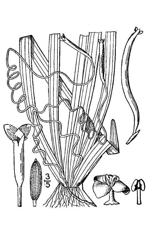
17 Vallisneria americana 17

18 Potamogeton zosteriformis 18

19 Utricularia vulgaris 19

20 Potamogeton gramineus 20
2015 Big Lake Aquatic Weed Control Program
 2015 Big Lake Aquatic Weed Control Program Prepared for Big Lake LMD #1 Skagit County Public Works Mount Vernon, Washington Prepared by Northwest Aquatic Eco-Systems, Inc. 855 Trosper Road SW #108-313
2016 Big Lake Aquatic Weed Control Program
 2016 Big Lake Aquatic Weed Control Program Prepared for Big Lake LMD #1 Skagit County Public Works Mount Vernon, Washington Prepared by Northwest Aquatic Eco-Systems, Inc. 855 Trosper Road SW #108-313
Beaver Lake 2012 Aquatic Plant Control Program
 Beaver Lake 2012 Aquatic Plant Control Program Prepared By Northwest Aquatic Eco-Systems 855 Trosper Road SW #108-313 Tumwater, WA 98512 360-357-3285 Pondweeds@comcast.net www.nwaquaticecosystems.com Project
Lake Campbell and Lake Erie 2015 Aquatic Plant Control Program
 Lake Campbell and Lake Erie 2015 Aquatic Plant Control Program Prepared for: Lake Erie & Campbell LMD #3 Skagit County Public Works Mount Vernon, Washington Prepared by: Northwest Aquatic Eco-Systems 855
Lake Campbell and Lake Erie 2012 Aquatic Plant Control Program
 Lake Campbell and Lake Erie 2012 Aquatic Plant Control Program Prepared By Northwest Aquatic Eco-Systems 855 Trosper Road SW #108-313 Tumwater, WA 98512 360-357-3285 Pondweeds@comcast.net www.nwaquaticecosystems.com
LAKE 11/1/2010. Clear
 CLEAR LAKE SKAGIT COUNTY, 20100 11/1/2010 Clear Lake 2010 Aquatic Plant Management Report Clear Lake Skagit County, 2010 Clear Lake Skagit County, 2010 CLEAR LAKE 2010 AQUATIC PLANT MANAGEMENT REPORT Introduction
AQUATIC VEGETATION SURVEY REPORT Year Two of Myriophyllum spicatum Management LAKE FAIRLEE Fairlee, West Fairlee & Thetford Vermont 2011
 AQUATIC VEGETATION SURVEY REPORT Year Two of Myriophyllum spicatum Management LAKE FAIRLEE Fairlee, West Fairlee & Thetford Vermont 2011 SUBMITTED: NOVEMBER 3, 2011 BY: William E. Stevenson, President
Clear Lake and Apsey Lake
 2013 Report of the Milfoil Solution Post Program Survey in Clear Lake and Apsey Lake Prepared for: The Town of Espanola, ON Prepared by: EnviroScience, Inc., 5070 Stow Road, Stow, Ohio 44224 (800) 940-4025
Lake Shirley 2013 Aquatic Vegetation Survey
 Lake Shirley 2013 Project Report October 18, 2013 Prepared For: Lake Shirley Improvement Corporation SECTION 1: INTRODUCTION Geosyntec Consultants (Geosyntec) was contracted by the Lake Shirley Improvement
2012 Lake Vegetation Summary Lake Sarah (Hennepin County)
") 2012 Lake Vegetation Summary Lake Sarah (Hennepin County) Introduction Lake Sarah is a 561 acre lake located near the town of Rockford in Hennepin County. It has a littoral area of 373 acres, and is dominated
2012 Lake Vegetation Summary Lake Sarah (Hennepin County) Introduction Lake Sarah is a 561 acre lake located near the town of Rockford in Hennepin County. It has a littoral area of 373 acres, and is dominated
HAM LAKE, ANOKA COUNTY: 2017 AQUATIC VEGETATION REPORT
 HAM LAKE, ANOKA COUNTY: 2017 AQUATIC VEGETATION REPORT Report by the Invasive Species Program Division of Ecological and Water Resources Minnesota Department of Natural Resources Lake: Ham (DOW# 02005300)
Pretty Lake Aquatic Vegetation Management Plan 2014 Update LaGrange County, Indiana
 Pretty Lake Aquatic Vegetation Management Plan 2014 Update LaGrange County, Indiana Prepared for: The Pretty Lake Conservation Club C/O Mr. Rod Bergstedt 4545 S 890 E Wolcottville, IN 46795 March 1, 2015
Lomond Lake ( ) Aquatic Vegetation Survey
 Aquatic Vegetation Survey") Lomond Lake (15-0081-00) Aquatic Vegetation Survey 22796 County Highway 6 Detroit Lakes, MN 56501 (218) 846-1465 www.rmbel.info Lake: Lomond Lake DOW Number: 15-0081-00 Date of inspection: 7/13/ 2015 County:
Lomond Lake (15-0081-00) Aquatic Vegetation Survey 22796 County Highway 6 Detroit Lakes, MN 56501 (218) 846-1465 www.rmbel.info Lake: Lomond Lake DOW Number: 15-0081-00 Date of inspection: 7/13/ 2015 County:
Aquatic Plant Control
 Tawas Lake Nuisance Aquatic Plant Control Report Prepared for: Tawas Lake Improvement Association Aquatic Plant Control Prepared by: Progressive AE 1811 4 Mile Road, NE Grand Rapids, MI 49525-2442 616/361-2664
Appendix B: Aquatic Herbicide Application Methods
 Appendix B: Aquatic Herbicide Application Methods William T. Haller: University of Florida, Gainesville FL; whaller@ufl.edu Introduction All pesticide labels contain very specific information regarding
GUIDANCE FOR DELINEATING INVASIVE AQUATIC PLANTS FOR MANAGMEMENT
 GUIDANCE FOR DELINEATING INVASIVE AQUATIC PLANTS FOR MANAGMEMENT Objectives 1. Delineating and qualifying boundaries of invasive aquatic plants for management purposes. 2. Collect additional information
Aquatic Plant Treatment Evaluation
 Aquatic Plant Treatment Evaluation Purpose and Applicability This protocol is used to evaluate the results of herbicide application or any other manipulation (but from here on called a chemical application
LAKE JOSEPHINE, RAMSEY COUNTY: 2017 AQUATIC VEGETATION REPORT
 LAKE JOSEPHINE, RAMSEY COUNTY: 2017 AQUATIC VEGETATION REPORT Report by the Invasive Species Program Division of Ecological and Water Resources Minnesota Department of Natural Resources Lake: Josephine
2013 Milfoil Weevil Stocking and Survey at Dewart Lake, Kosciusko County, Indiana. The Dewart Lake Protective Association
 2013 Milfoil Weevil Stocking and Survey at Dewart Lake, Kosciusko County, Indiana The Dewart Lake Protective Association Project No. 1639-3921 Date: November 8, 2013 1.0 Introduction Eurasian watermilfoil
Charley Lake. Macrophyte and Biovolume Survey 8/04/17
 Charley Lake 8/04/17 This document contains two types of vegetation data collected on Charley Lake. The first section details the methods and findings of a point intercept survey of macrophyte vegetation.
Aquatic Plant Point-Intercept Survey for Haas Lake, Scott County, Minnesota
 Haas Lake, Scott County, Minnesota, 2017 Aquatic Plant Point-Intercept Survey for Haas Lake, Scott County, Minnesota [Plant Survey Conducted August 29, 2017] Prepared for: Prior Lake-Spring Lake Watershed
Wilkinson Lake. Macrophyte and Biovolume Survey 8/11/17
 Wilkinson Lake 8/11/17 This document contains two types of vegetation data collected on Wilkinson Lake. The first section details the methods and findings of a point intercept survey of macrophyte vegetation.
2015 YEAR-END REPORT
 2015 YEAR-END REPORT Fanwort (Cabomba caroliniana) Control in Gooseberry Cove, Wequaquet Lake, and Bearse Pond - Barnstable, Massachusetts March 2016 Prepared for: Town of Barnstable c/o Office of the
Spokane River Project Aquatic Weed Management Program
 Spokane River Project Aquatic Weed Management Program David Armes Terrestrial Resource Specialist (509) 495-2796 david.armes@avistacorp.com Aquatic Weeds, Why Should You Care? Invasive aquatic weeds degrade
Long Lake ( ) Aquatic Vegetation Survey
 Aquatic Vegetation Survey") Long Lake (15-0057-00) Aquatic Vegetation Survey 22796 County Highway 6 Detroit Lakes, MN 56501 (218) 846-1465 www.rmbel.info Lake: Long Lake DOW Number: 15-0057-00 Date of inspection: 7/14/ 2015 County:
Long Lake (15-0057-00) Aquatic Vegetation Survey 22796 County Highway 6 Detroit Lakes, MN 56501 (218) 846-1465 www.rmbel.info Lake: Long Lake DOW Number: 15-0057-00 Date of inspection: 7/14/ 2015 County:
Lake St. Catherine. Aquatic Vegetation Management Program Year Eight Report. October Prepared for: Prepared by:
 Lake St. Catherine Aquatic Vegetation Management Program 2011 - Year Eight Report October 2011 Prepared for: Lake St. Catherine Association c/o Jim Canders, President 443 Old Best Road West Sand Lake,
Treatment Report. Professional Lake Management (PLM) was awarded a contract to manage Flowering Rush within the Pelican River Watershed District.
 was awarded a contract to manage Flowering Rush within the Pelican River Watershed District.") Patrick Selter V.P. PLM Lake and Land Management 9/8/2008 Treatment Report Background Professional Lake Management (PLM) was awarded a contract to manage Flowering Rush within the Pelican River Watershed
Patrick Selter V.P. PLM Lake and Land Management 9/8/2008 Treatment Report Background Professional Lake Management (PLM) was awarded a contract to manage Flowering Rush within the Pelican River Watershed
Vegetation survey of South Lindstrom Lake ( ), Chisago County, Minnesota. Summer 2010
, Chisago County, Minnesota. Summer 2010") Minnesota Dept. of Natural Resources Division of Fish and Wildlife Section of Fisheries Vegetation survey of South Lindstrom Lake (13-0028), Chisago County, Minnesota Summer 2010 Area Fisheries Supervisor
Minnesota Dept. of Natural Resources Division of Fish and Wildlife Section of Fisheries Vegetation survey of South Lindstrom Lake (13-0028), Chisago County, Minnesota Summer 2010 Area Fisheries Supervisor
Town of Barnstable Hydrilla Control Program: Long Pond, Mystic Lake & Middle Pond
 Town of Barnstable 2014 Hydrilla Control Program: Long Pond, Mystic Lake & Middle Pond Hydrilla (Hydrilla verticillata) Management Program Activities Project Completion Report for 2014 Hydrilla Management
Fish Lake; Echo Bay ( ) Aquatic Vegetation Survey
 Aquatic Vegetation Survey") Fish Lake; Echo Bay (56-0768-00) Aquatic Vegetation Survey 22796 County Highway 6 Detroit Lakes, MN 56501 (218) 846-1465 www.rmbel.info Lake: Fish Lake; Echo Bay DOW Number: 56-0768-00 Date of inspection:
Fish Lake; Echo Bay (56-0768-00) Aquatic Vegetation Survey 22796 County Highway 6 Detroit Lakes, MN 56501 (218) 846-1465 www.rmbel.info Lake: Fish Lake; Echo Bay DOW Number: 56-0768-00 Date of inspection:
BIG CARNELIAN LAKE, WASHINGTON COUNTY: 2017 AQUATIC VEGETATION REPORT
 BIG CARNELIAN LAKE, WASHINGTON COUNTY: 2017 AQUATIC VEGETATION REPORT Report by the Invasive Species Program Division of Ecological and Water Resources Minnesota Department of Natural Resources Lake: Big
Restorative Lake Sciences West Spring Lake Road Spring Lake, Michigan Website:
 Wamplers Lake 2017 Aquatic Vegetation, Water Quality, 2018 Management Recommendations Report November, 2017 Wamplers Lake 2017 Aquatic Vegetation, Water Quality, & 2018 Management Recommendations Report
Kerr Lake Vegetation Survey. October November Report submitted by NC State University. Background
 Kerr Lake Vegetation Survey October November 2011 Report submitted by NC State University Background Hydrilla (Hydrilla verticillata) is a non-native invasive submersed aquatic plant. This plant was first
Restorative Lake Sciences West Spring Lake Road Spring Lake, Michigan Website:
 Eagle Lake 2016 Aquatic Vegetation & Water Quality Report & 2017 Management Recommendations October, 2016 Eagle Lake 2016 Aquatic Vegetation & Water Quality Report & 2017 Management Recommendations Restorative
Restorative Lake Sciences West Spring Lake Road Spring Lake, Michigan Website:
 Duck Lake 2017 Aquatic Vegetation, Water Quality, and 2018 Management Recommendations Report December, 2017 Duck Lake 2017 Aquatic Vegetation, Water Quality, and 2018 Management Recommendations Report
Black Lake Integrated Aquatic Vegetation Management Plan. Harry Gibbons Toni Pennington Shannon Brattebo
 Black Lake Integrated Aquatic Vegetation Management Plan Harry Gibbons Toni Pennington Shannon Brattebo 1 Benefits of Native Plants Provide diverse habitat for fish & wildlife Competes with algae for nutrients
Pine Lake ( ) Aquatic Vegetation Survey
 Aquatic Vegetation Survey") Pine Lake (15-0149-00) Aquatic Vegetation Survey 22796 County Highway 6 Detroit Lakes, MN 56501 (218) 846-1465 www.rmbel.info Lake: Pine Lake DOW Number: 15-0149-00 Date of inspection: 6/30, 7/2/ 2015
Pine Lake (15-0149-00) Aquatic Vegetation Survey 22796 County Highway 6 Detroit Lakes, MN 56501 (218) 846-1465 www.rmbel.info Lake: Pine Lake DOW Number: 15-0149-00 Date of inspection: 6/30, 7/2/ 2015
Aquatic Plant Point-Intercept Surveys for Sea Lake, Scandia, Minnesota, 2016
 Sea Lake, Scandia, Minnesota, June 20, 2015 Aquatic Plant Point-Intercept Surveys for Sea Lake, Scandia, Minnesota, 2016 [Plant Surveys Conducted: June 2 and August 23, 2016] Prepared for: Comfort Lake
Aquatic Plant Point-Intercept Survey for Forest Lake, Washington County, 2013
 Example of Aquatic Plants sampled in July 2013 on Forest Lake Aquatic Plant Point-Intercept Survey for Forest Lake, Washington County, 2013 Point-Intercept Aquatic Plant Survey: July 11 and 12, 2013 Prepared
January 30, Ms. Joanna Bilotta, President Lake Shirley Improvement Corporation (LSIC) PO Box 567 Shirley, MA 01464
 PO Box 567 Shirley, MA 01464") January 30, 2014 Ms. Joanna Bilotta, President Lake Shirley Improvement Corporation (LSIC) PO Box 567 Shirley, MA 01464 Re: 2013 Year End Report for the Aquatic Management Program at Lake Shirley Dear
January 30, 2014 Ms. Joanna Bilotta, President Lake Shirley Improvement Corporation (LSIC) PO Box 567 Shirley, MA 01464 Re: 2013 Year End Report for the Aquatic Management Program at Lake Shirley Dear
Point-Intercept Aquatic Plant Surveys for Bone Lake, Washington County, Minnesota
 Bone Lake, Washington County, Minnesota, May 28, 2013 Point-Intercept Aquatic Plant Surveys for Bone Lake, Washington County, Minnesota Early Season Survey: May 28, 2013 Late Season Survey: September 13,
Friends of Bolton Lakes 2016 Aquatic Plant Surveys
 Friends of Bolton Lakes 2016 Aquatic Plant Surveys The Friends of Bolton Lakes conducted their annual aquatic plant surveys of Lower and Middle Bolton Lakes on July 20 and 21. The surveys were performed
Restorative Lake Sciences West Spring Lake Road Spring Lake, Michigan Website:
 Marcellus Lakes 2017 Aquatic Vegetation, Water Quality, and 2018 Management Recommendations November, 2017 Marcellus Lakes 2017 Aquatic Vegetation, Water Quality, & 2018 Management Recommendations Report
Cocolalla Lake Bathymetry Information and Proposal
 April 17, 2014 Fred Vincent President Cocolalla Lake Association PO Box 133 Cocolalla, ID 83813 Subject: Cocolalla Lake Bathymetry Information and Proposal With respect to our recent communication regarding
Lower Bolton Lake Status Up-Date
 Lower Bolton Lake Status Up-Date Prepared for: Town of Bolton Bolton, CT Prepared by: Northeast Aquatic Research, LLC Mansfield, CT May 8, 217 June 19, 217 October 31, 217 1 P age Purpose This report is
AMENDMENT Aquatic Plant Management Plan, Lake Wingra, Lower Rock River Basin, Dane County Wisconsin Draft May 1, 2013
 AMENDMENT Aquatic Plant Management Plan, Lake Wingra, Lower Rock River Basin, Dane County Wisconsin Draft May 1, 2013 Prepared by Sue Jones, Dane County Office of Lakes and Watersheds, with assistance
Eurasian water milfoil (Myriophyllum spicatum) Pre/Post Herbicide and Bed Mapping Surveys Minong Flowage (WBIC: ) Washburn County, Wisconsin
 Pre/Post Herbicide and Bed Mapping Surveys Minong Flowage (WBIC: ) Washburn County, Wisconsin") Eurasian water milfoil (Myriophyllum spicatum) Pre/Post Herbicide and Bed Mapping Surveys Minong Flowage (WBIC: 2692900) Washburn County, Wisconsin Project Initiated by: Wisconsin Department of Natural
Eurasian water milfoil (Myriophyllum spicatum) Pre/Post Herbicide and Bed Mapping Surveys Minong Flowage (WBIC: 2692900) Washburn County, Wisconsin Project Initiated by: Wisconsin Department of Natural
RESULTS OF THE POST-APPLICATION VEGETATION SURVEY OF GOOSE BAY, NEW YORK
 RESULTS OF THE POST-APPLICATION VEGETATION SURVEY OF GOOSE BAY, NEW YORK FINAL REPORT PREPARED FOR: GOOSE BAY RECLAMATION CORPORATION PREPARED BY: Lee H. Harper and Anne Johnson Riveredge Associates, LLC,
2018 Data Report for. Park Lake, Clinton County
 Michigan Lakes Ours to Protect 218 Data Report for Park Lake, Clinton County Site ID: 1999 42.7897 N, 84.4311 W The CLMP is brought to you by: 1 About this report: This report is a summary of the data
Ms. Patricia Edelstein Friends of Lake Garfield c/o September 5, Dear Pat:
 Water Resource Services Inc. 144 Crane Hill Road Wilbraham, MA 01095 kjwagner@charter.net 413-219-8071 Ms. Patricia Edelstein Friends of Lake Garfield c/o mdrn1hart@gmail.com September 5, 2013 Dear Pat:
INTEROFFICE MEMORANDUM 2012 REPORT - HONEOYE LAKE AQUATIC VEGETATION MANAGEMENT PROGRAM (AVMP)
") ONTARIO COUNTY Planning Department Darlys McDonough, Interim Director INTEROFFICE MEMORANDUM TO: FROM: SUBJECT: MEMBERS, ONTARIO COUNTY BOARD OF SUPERVISORS BETSY LANDRE, SENIOR PLANNER 2012 REPORT - HONEOYE
ONTARIO COUNTY Planning Department Darlys McDonough, Interim Director INTEROFFICE MEMORANDUM TO: FROM: SUBJECT: MEMBERS, ONTARIO COUNTY BOARD OF SUPERVISORS BETSY LANDRE, SENIOR PLANNER 2012 REPORT - HONEOYE
Aquatic Plants and Management in Valley Branch Watershed District (VBWD) Lakes. DNR-VBWD Meeting. February 13, 2017
 Lakes. DNR-VBWD Meeting. February 13, 2017") Aquatic Plants and Management in Valley Branch Watershed District (VBWD) Lakes DNR-VBWD Meeting February 13, 2017 Goals Goals Gain consensus whether there is a problem with aquatic plants (particularly
Aquatic Plants and Management in Valley Branch Watershed District (VBWD) Lakes DNR-VBWD Meeting February 13, 2017 Goals Goals Gain consensus whether there is a problem with aquatic plants (particularly
McMAHON LAKE, SCOTT COUNTY: 2017 AQUATIC VEGETATION REPORT
 McMAHON LAKE, SCOTT COUNTY: 2017 AQUATIC VEGETATION REPORT Report by the Invasive Species Program Division of Ecological and Water Resources Minnesota Department of Natural Resources Lake: McMahon (DOW#
Re: 2010 Aquatic Plant Management Program Report at Hamilton Reservoir - Holland, MA & Union, CT
 December 7, 21 Lake Oversight Committee Town of Holland 27 Sturbridge Road Holland, MA 1521 Re: 21 Aquatic Plant Management Program Report at Hamilton Reservoir - Holland, MA & Union, CT Dear Members of
STEEL LAKE MANAGEMENT DISTRICT 2015 Final Report
 STEEL LAKE MANAGEMENT DISTRICT 2015 Final Report Prepared by: Hollie Shilley City of Federal Way Public Works Department Surface Water Management Division ACKNOWLEDGMENTS The City of Federal Way acknowledges
* Minong Flowage. Posttreatment EWM in WDRN Boat Landing Bay 6/15/16
 Eurasian Water-milfoil (Myriophyllum spicatum) Pre/Post Herbicide and Fall Bed Mapping Surveys Minong Flowage - (WBIC: 2692900) Washburn and Douglas Counties, Wisconsin Canopied EWM mixed with wild rice
DEVIL S AND ROUND LAKES AQUATIC VEGETATION SURVEY AND MANAGEMENT PLAN REPORT
 DEVIL S AND ROUND LAKES AQUATIC VEGETATION SURVEY AND MANAGEMENT PLAN REPORT POINT-INTERCEPT GRID AND AVAS SURVEYS OF AQUATIC VEGETATION IN DEVIL S AND ROUND LAKES LENAWEE COUNTY, MICHIGAN AUGUST 2007
Minnesota Department of Natural Resources. Aquatic Plant Management Program
 Minnesota epartment of Natural Resources Aquatic Plant Management Program The Goal of the MN NR s Aquatic Plant Management Program-APM Protect & enhance Minnesota s aquatic resources, while allowing lakeshore
Hatch Pond Water Quality Assessment, 2010 Update
 Hatch Pond Water Quality Assessment, 2010 Update Prepared for: Kent Land Trust, Inc. 170 Kent Road, Kent, CT 06757 Prepared by: Northeast Aquatic Research, LLC 74 Higgins Highway, Mansfield, CT 06250 June
City of Kenmore Integrated Aquatic Vegetation Management Plan (IAVMP)
") City of Kenmore Integrated Aquatic Vegetation Management Plan (IAVMP) Public Meeting #1 Facilitated by: Janet Quinn, Project Coordinator, City of Kenmore Rob Zisette, Aquatic Scientist, Herrera Environmental
City of Kenmore Integrated Aquatic Vegetation Management Plan (IAVMP) Public Meeting #1 Facilitated by: Janet Quinn, Project Coordinator, City of Kenmore Rob Zisette, Aquatic Scientist, Herrera Environmental
Request for Qualifications
 Request for Qualifications Analysis of Treatment Alternatives for Invasive Watermilfoil in Noxon and Cabinet Gorge Reservoirs, Sanders County, Montana Project Overview The Sanders County Aquatic Invasive
Silver Lake Waushara County, Wisconsin 2016 AIS Aquatic Pesticide Application Report
 Silver Lake Waushara County, Wisconsin 2016 AIS Aquatic Pesticide Application Report Initial Treatment Tracks 5/26/2016 Second Treatment Tracks 7/21/2016 Third Treatment Tracks 9/1/2016 Prepared By: www.cleanlakesmidwest.com
Control of Eurasian Milfoil (Myriophyllum spicatum) using wind powered water circulators at Lake Cayamant, Quebec, CANADA.
 using wind powered water circulators at Lake Cayamant, Quebec, CANADA.") 146 Dalesville, Brownsburg-Chatham. Quebec,Canada. J8G-1H4 Tel : 450-533-9191 Fax : 450-533-9175 E-mail : info@lake2000.com Web : www.lake2000.com Control of Eurasian Milfoil (Myriophyllum spicatum) using
146 Dalesville, Brownsburg-Chatham. Quebec,Canada. J8G-1H4 Tel : 450-533-9191 Fax : 450-533-9175 E-mail : info@lake2000.com Web : www.lake2000.com Control of Eurasian Milfoil (Myriophyllum spicatum) using
Successful Operational Use of Renovate OTF for Selective Control of Myriophyllum hll spicatum (Eurasian watermilfoil) in Three New York Lakes:
 in Three New York Lakes:") Successful Operational Use of Renovate OTF for Selective Control of Myriophyllum hll spicatum (Eurasian watermilfoil) in Three New York Lakes: Saratoga, Lamoka, Waneta Authors: Mark Heilman, Ph.D., SePRO
Successful Operational Use of Renovate OTF for Selective Control of Myriophyllum hll spicatum (Eurasian watermilfoil) in Three New York Lakes: Saratoga, Lamoka, Waneta Authors: Mark Heilman, Ph.D., SePRO
Lake Quassapaug 2014 Study Results
 Lake Quassapaug 2014 Study Results February 23, 2015 Northeast Aquatic Research, LLC NEAR 2014 Scope Review Eurasian milfoil distribution June 18 Collect one round of water quality data June 18 Lake-wide
Effectiveness of Temporary Carp Barriers for Promoting Wild Rice Growth in a Southern Bay of Upper Clam Lake
 www.fixmylake.com 18029 83 rd Avenue North Maple Grove, MN 55311 mail@freshwatersci.com (651) 336-8696 Effectiveness of Temporary Carp Barriers for Promoting Wild Rice Growth in a Southern Bay of Upper
1. Project Title Chemical control of water chestnut in Finger Lakes and Great Lakes Region.
 1. Project Title Chemical control of water chestnut in Finger Lakes and Great Lakes Region. 2. Project Description In late June to early August, the contractor will perform herbicide treatment of water
DOC ID All restrictions and precautions on the EPA registered label are to be followed.
 DOC ID 538887 Sonar Genesis Aquatic Herbicide Sonar Genesis Aquatic Herbicide EPA Reg. No. 67690-54 24(c) Special Local Need Registration (SLN NY-120006) June 2, 2014 FOR DISTRIBUTION AND USE ONLY IN THE
2014 AQUATIC VEGETATION SURVEY
 Cedar Lake, Scott County: 2014 AQUATIC VEGETATION SURVEY Report by the Invasive Species Program Division of Ecological and Water Resources Minnesota Department of Natural Resources Lake: Cedar Lake (DOW#70009100)
Provided for: The Residents of Center Lake, the Sherman Township Board & the Kettunen Center
 Center Lake 2016 Aquatic Vegetation & Water Quality Report & 2017 Management Recommendations October, 2016 Center Lake 2016 Aquatic Vegetation & Water Quality Report & 2017 Management Recommendations Provided
Aquatic Vegetation of Green Lake Isanti County, Minnesota (DOW ) June 14-15, 2005
 June 14-15, 2005") Aquatic Vegetation of Green Lake Isanti County, Minnesota (DOW 30-0136-00) June 14-15, 2005 Green Lake (DOW 30-0136-00) Isanti Co. June 15, 2005 Report by: Donna Perleberg Minnesota Department of Natural
Aquatic Vegetation of Green Lake Isanti County, Minnesota (DOW 30-0136-00) June 14-15, 2005 Green Lake (DOW 30-0136-00) Isanti Co. June 15, 2005 Report by: Donna Perleberg Minnesota Department of Natural
AQUATIC VEGETATION MANAGEMENT PROGRAM LAKE GASTON 2017 TREATMENT SUMMARY AND RECOMMENDATIONS
 AQUATIC VEGETATION MANAGEMENT PROGRAM LAKE GASTON 2017 TREATMENT SUMMARY AND RECOMMENDATIONS PREPARED BY PLM LAKE AND LAND MANAGEMENT CORPORATION December 2017 INDEX I. INTRODUCTION II. III. IV. 2017 AQUATIC
AQUATIC VEGETATION MANAGEMENT PROGRAM LAKE GASTON 2018 TREATMENT SUMMARY AND RECOMMENDATIONS
 AQUATIC VEGETATION MANAGEMENT PROGRAM LAKE GASTON 2018 TREATMENT SUMMARY AND RECOMMENDATIONS PREPARED BY PLM LAKE AND LAND MANAGEMENT CORPORATION December 2018 INDEX I. INTRODUCTION II. III. IV. 2018 AQUATIC
Control of Eurasian Water Milfoil & Large-scale Aquatic Herbicide Use Updated July 2006 Prepared by WDNR Lakes and Aquatic Plant Management Staff
 Control of Eurasian Water Milfoil & Large-scale Aquatic Herbicide Use Updated July 2006 Prepared by WDNR Lakes and Aquatic Plant Management Staff Introduction The spread of aquatic invasive plants is a
Shipshewana Lake Aquatic Vegetation Management Plan Lagrange County, Indiana
 Shipshewana Lake Aquatic Vegetation Management Plan Lagrange County, Indiana 2006-2010 http://129.79.145.7/arcims/statewide%5fmxd/viewer.htm Prepared for: The Shipshewana Community Lake Improvement Association
STATE OF MICHIGAN DEPARTMENT OF ENVIRONMENTAL QUALITY
 STATE OF MICHIGAN DEPARTMENT OF ENVIRONMENTAL QUALITY INDIVIDUAL PERMIT FOR PESTICIDE APPLICATION TO SURFACE WATERS OF THE STATE OF MICHIGAN Permits are required by Part 31, Water Resources Protection,
STATE OF MICHIGAN DEPARTMENT OF ENVIRONMENTAL QUALITY
 STATE OF MICHIGAN DEPARTMENT OF ENVIRONMENTAL QUALITY STANDARD PERMIT FOR PESTICIDE APPLICATION TO SURFACE WATERS OF THE STATE OF MICHIGAN Permits are required by Part 31, Water Resources Protection, of
Flowering Rush Delineation, Control, and Assessment for Forest Lake, Washington County, Minnesota, 2016
 in Forest Lake, July, 2016, Control, and Assessment for Forest Lake, Washington County, Minnesota, 2016 : July 14 and 15, 2016 Herbicide Treatments on 36 acres: August 3 and 31, 2016 Assessment: September
Evaluation of aquatic plant control via automated mechanical roller system
 Evaluation of aquatic plant control via automated mechanical roller system T.L. Brandt 1 INTRODUCTION Canadarago Lake (N42 o 48.9, W75 o.4 ), 39 m (128ft) above sea level, is located in the towns of Exeter,
Sustainable Lake Management Plan. Black Lake, Ramsey County, MN
 Sustainable Lake Management Plan Black Lake, Ramsey County, MN Prepared by Kristine Jenson, Program Manager 2015 This page was left blank intentionally. BLACK LAKE SUSTAINABLE LAKE MANAGEMENT PLAN - 2015
Postemergence 2.0 lbs. acid equivalent For best results, treat when weeds are young and actively growing.
 WEEDS AND BRUSH ON IRRIGATION Maximum Application Rate per Acre Directions and Timing CANAL DITCHBANKS Postemergence 2.0 lbs. acid equivalent For best results, treat when weeds are young and actively growing.
Use of Herbicides for Control of Submersed Vegetation
 Use of Herbicides for Control of Submersed Vegetation Jeremy G. Slade United Phosphorus, Inc. Gainesville, FL Flood Control and Water Delivery Protect Wildlife Habitat Water Use: Hunting? Fishing? Skiing?
An Aquatic Plant Lake Plan for Golden Lake Waukesha County, WI November, 2017
 An Aquatic Plant Lake Plan for Golden Lake Waukesha County, WI November, 2017 Acknowledgements Marine Biochemists would like to thank members of the Golden Lake Association for their financial commitment,
Prepared by: Skamania County Noxious Weed Control Program Post Office Box Rock Creek Drive Stevenson, Washington
 Skamania County Cooperative Indigobush Control Project Project Completion Report Washington State Department of Natural Resources Aquatic Land Grant IL 14-249 Prepared by: Skamania County Noxious Weed
Deep Creek Lake Submerged Aquatic Vegetation Survey
 Deep Creek Lake Submerged Aquatic Vegetation Survey Report of Summer 2010 Survey Activity February 4, 2011 ABSTRACT Maryland Department of Natural Resources (DNR) Resource Assessment Service (RAS) staff
Aquatic Plant Surveys and Curlyleaf Pondweed Evaluation for Spring Lake, Scott County, Minnesota in 2010
 Scattered Stems of Curlyleaf Pondweed in Spring Lake on April 7, 010 Aquatic Plant Surveys and Curlyleaf Pondweed Evaluation for Spring Lake, Scott County, Minnesota in 010 No Open Lake Herbicide Application
West Battle Lake. Aquatic Vegetation Survey County Highway 6 Detroit Lakes, MN (218)
") West Battle Lake Aquatic Vegetation Survey 2017 22796 County Highway 6 Detroit Lakes, MN 56501 (218) 846-1465 www.rmbel.info Lake: West Battle DOW Number: 56-0239-00 Date of inspection: June 26-29, 2017
West Battle Lake Aquatic Vegetation Survey 2017 22796 County Highway 6 Detroit Lakes, MN 56501 (218) 846-1465 www.rmbel.info Lake: West Battle DOW Number: 56-0239-00 Date of inspection: June 26-29, 2017
INDIAN BROOK RESERVOIR
 INDIAN BROOK RESERVOIR 2011 Aquatic Vegetation Surveys Report and Version: November 2011 Prepared for: Town of Essex c/o Mark Berry, Parks and Recreation Director 81 Main Street Essex Junction, VT 05452
Fish Ecology and Management Workshop. Fisheries management options
 Fish Ecology and Management Workshop Fisheries management options Management Options to Enhance Fishing (Lake Assn.) Stocking Artificial Structures Vegetation Control Natural shoreline Other considerations
What have we learned about managing starry stonewort (Nitellopsis obtusa)? Scott Van Egeren Wisconsin DNR
? Scott Van Egeren Wisconsin DNR") What have we learned about managing starry stonewort (Nitellopsis obtusa)? Scott Van Egeren Wisconsin DNR Acknowledgements SePro Jake Britton West Bishop Ben Willis JT Gravelie Waukesha County Brad Steckart
What have we learned about managing starry stonewort (Nitellopsis obtusa)? Scott Van Egeren Wisconsin DNR Acknowledgements SePro Jake Britton West Bishop Ben Willis JT Gravelie Waukesha County Brad Steckart
COUNTY OF CHAUTAUQUA, NEW YORK A Municipal Corporation Gerace Office Building Mayville, New York hereinafter called "County," -and-
 19- MEMORANDUM OF AGREEMENT Chautauqua Lake Weed Management Consensus Strategy This Agreement is made as of May 1, 2019, by and between the following parties: COUNTY: COUNTY OF CHAUTAUQUA, NEW YORK A Municipal
Webster Lake Aquatic Vegetation Management Plan Review & Update
 Webster Lake Aquatic Vegetation Management Plan Review & Update Nathan W. Long VP Lake Management Services September 8, 2016 LARE Review State funds received from fee on boat registration Administered
LONG LAKE, THURSTON COUNTY
 AQUATIC NUISANCE WEED CONTROL PRESCRIPTION LONG LAKE, THURSTON COUNTY The goal of this Nuisance Aquatic Plant Program is to protect beneficial uses and the natural environment of the lake while maintaining
Prepared for: Prepared by:
 Eurasian Watermilfoil Strategic Biological Control Program 2011 Progress Report Prepared for: Les Chenea ux Islands Watershed Council Prepared by: EnviroScience, Inc., 3781 Darrow Road, Stow, Ohio 44224
Aquatic Plant Control
 Thompson Lake 2015 Annual Nuisance Aquatic Plant Control Report Prepared for: Thompson Lake Improvement Board c/o Livingston County Drain Commissioner's Office 2300 E Grand River Ave. Suite 105 Howell,
AQUATIC PLANT MANAGEMENT PLAN FOR U.S. ARMY CORPS OF ENGINEERS, SAVANNAH DISTRICT WATER RESOURCES PROJECTS SOUTH CAROLINA AND GEORGIA
 AQUATIC PLANT MANAGEMENT PLAN FOR U.S. ARMY CORPS OF ENGINEERS, SAVANNAH DISTRICT WATER RESOURCES PROJECTS SOUTH CAROLINA AND GEORGIA Appendix A CY 2014 Update Annual Aquatic Plant Treatment Plan and Summary
FINAL REPORT for PHASE II. Lake Management Plan for Invasive Species Control in Escanaba Municipal Marina
 FINAL REPORT for PHASE II Lake Management Plan for Invasive Species Control in Escanaba Municipal Marina by H 2 O in Motion, Inc. Troy R. Gallagher, President 423 Ludington Street Escanaba, MI 49829 906.553.7636
JORDAN LAKE MANAGEMENT6 PLAN PT 2--REVISED 8/16/14 Page 19 ITEM GOALS and ACTION ITEMS WHO WHEN
 JORDAN LAKE MANAGEMENT6 PLAN PT 2--REVISED 8/16/14 Page 19 EDUCATION Goal A: Educate community and public about lake management concerns. 1. Establish community events to encourage & educate the community
Resource Conservation Opportunities and Management Guidelines
 Resource Conservation Opportunities and Management Guidelines The general ecosystem integrity of lakes is dependent on preserving natural habitat components and the processes that sustain them. These include
Idaho s Eurasian Watermilfoil Program. Tom Woolf Aquatic Plant Program Manager Idaho State Department of Agriculture
 Idaho s Eurasian Watermilfoil Program Tom Woolf Aquatic Plant Program Manager Idaho State Department of Agriculture Idaho s Milfoil Program Idaho Program History Treatment Prevention Education Idaho s