Solutions towards hydrological challenges in Africa in support of hydropower developments Ms. Catherine Blersch, Civil Engineer, Aurecon, South
|
|
|
- Bernard Isaac Edwards
- 5 years ago
- Views:
Transcription

1 Solutions towards hydrological challenges in Africa in support of hydropower developments Ms. Catherine Blersch, Civil Engineer, Aurecon, South Africa Dr Verno Jonker, Civil Engineer, Aurecon, South Africa
2 Outline of Presentation 1. Background and Context 2. Data Collection and Review 3. Rainfall-Runoff Modelling 4. System Analysis 5. Design Flood Analysis 6. Lessons Learnt
3 1 Background and Context Background Huge potential for hydropower development in Africa Growing need for clean and sustainable power Numerous investigations into both large- and smallscale hydropower projects across the African continent
4 1 Background and Context Problem Statement: Hydrology is an essential component of any hydropower project Long term flow sequences required to determine viability of hydropower project (generation capacity) Flow sequences required for design and operation Flood hydrographs and levels required for design of hydropower dams and associated infrastructure
5 1 Background and Context Conventional Approach Quality assured data available from relevant local/national department Published local/national manuals, guidelines and standards for design Localised information available regarding design rainfall, runoff coefficients, catchment response characteristics Established techniques that have been tried and tested in the area can be readily applied
6 1 Background and Context Challenges in Africa Difficult to source data Often have to pay large sums for poor quality data No quality control data is often unverified Only average daily flow values no instantaneous daily peaks Very rare to find concurrent rainfall and flow data within a catchment often calculations from adjacent catchments must be applied In many countries flow data stops in the 70 s / 80 s due to political instability or war Rating curves are not updated regularly Conflicting data from different sources
7 2 Data Collection and Review Topographical Data 90m x 90m NASA Shuttle Radar Topographic Mission (SRTM) DEM ArcHydro used to delineate sub-catchments Perry Castaneda Library (Topographical maps etc.) Land Cover / Vegetation Freely available images and maps online Satellite imagery Soil Types Soil maps available from EU Soils

8 2 Data Collection and Review
9 2 Data Collection and Review Monthly and Daily Rainfall Data FAOClim 2.0 Software CD database available for all countries in Africa National Oceanographic and Atmospheric Administration (NOAA) National meteorological / hydrological institutes Data available in previous reports and publications Colonial databases and yearbooks Evaporation Data Monthly averages available in FAOClim 2.0 Very important to take note of the type of evaporation data (A-Pan, S-Pan, Pennman Monteith etc.)
10 2 Data Collection and Review Monthly and Daily Flow Data: Global Runoff Data Centre Recent flows often recorded by developers, new mines etc. National hydrological institutes Data available in previous reports and publications Substantiate with anecdotal evidence from locals (e.g. recollections of large floods) and spot checks
11 2 Data Collection and Review Data Review and Quality Control: Single mass plot shows whether significant portions of data are missing and confirms stationarity Missing values are flagged particular attention paid to missing values in wet months for flood analysis For catchment modelling missing rainfall and flow values can be patched using adjacent stations and advanced regression techniques Potential outliers are flagged often better to assess the sensitivity if they are included or excluded rather than excluding them outright

12 2 Data Collection and Review Typical Single Mass Plot:
13 3 Rainfall-Runoff Modelling A flow duration curve is required to determine the design flows for hydropower generation Often empirical approaches are applied very simplified and not based on long term sequences Observed records are often very short therefore only using observed records can be careless Long term flow sequences are required to realistically determine the long term assurance of supply
14 3 Rainfall-Runoff Modelling Various models can be applied Water Resource Simulation Model (WRSM2000) WRSM2000 employs the lumped conceptual Pitman rainfall-runoff model Operates on the network principle which allows water to be transferred between modules, depending on a user-specified configuration for the system South African model but has been applied successfully in a number of African countries including Angola, Nigeria, DRC, Cameroon, Namibia, Botswana, Zimbabwe and Mozambique
15 3 Rainfall-Runoff Modelling Catchment Parameters: Name Zmin Zmax POW TL ST FT Description Minimum absorption rate (mm/month) Maximum absorption rate (mm/month) Power of the runoff vs. soil moisture capacity Time lag of Runoff (months) Maximum soil moisture capacity (mm) Runoff rate from soil when soil moisture is at full capacity (mm/month) R GW GL SL PI Controls rate at which evaporation reduces as soil moisture is depleted (Coefficient in the evaporation soil moisture equation) Maximum groundwater runoff (mm/month) Lag of subsurface flow in the lower zone (months) Soil moisture state below which no runoff occurs (mm) Interception storage (mm)

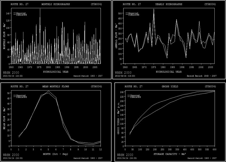
16 3 Rainfall-Runoff Modelling Typical Calibration Results:
17 3 Rainfall-Runoff Modelling Results: Long term sequence used to produce a flow duration curve: 80% of the time the flow exceeds 78 m 3 /s
18 4 System Analysis For a run-of-river project long term sequences alone are sufficient For a hydropower dam, system modelling often required to determine assurance of supply System modelling allows for consideration of dam operating rules and additional water uses Simple systems can be modelled in excel Water Resource Yield Model has been successfully applied on a number of projects across Africa
19 4 System Analysis Water Resource Yield Model (WRYM): Monthly time-step model that simulates the behaviour of reservoirs or water supply systems Includes inflows, storage, demands and operating rules Outputs the number of times that the dam cannot meet the target demand over the analysis period Used to determine the assurance of supply and optimise the target drafts from the dam Uses sophisticated network solver Historical and stochastic models are available
20 4 System Analysis Typical Network Diagram: 1 - [1] SPILL ZONE ZONE DSL [2] to to domestic irrigation 100% x [1] Kash 1 Kashimbila Dam seepage 1 - [1] 0 to inf [2] to to [2] to to [1] 0 to inf [3] to to YIELD Spill 14 - [3] to to [3] to to

21 4 System Analysis Typical reservoir simulation and results: Month Flow rate Assurance of (m 3 /s) Supply (%) Oct % Nov % Dec % Jan 80 75% Feb 70 75% Mar 59 75% Apr 82 77% May % Jun % Jul 79 74% Aug 70 74% Sep %
22 5 Design Flood Analysis Statistical Methods Deterministic Methods Empirical Methods
23 5 Design Flood Analysis Typical approaches to design flood in Africa: Empirical approaches to unit hydrographs are often applied which are not applicable in Africa Single site statistical analysis is often favoured with no attention to record length or the type of flow data Extrapolating statistical results from short records to large recurrence intervals (e.g. 1 in year check flood) is very dangerous Deterministic methods often not used or the simpler methods are used where not applicable (e.g. on very large catchments)
24 5 Design Flood Analysis Statistical Methods: If daily flow data is available, the annual maxima can be extracted and a statistical distribution fit to determine floods for various recurrence intervals Statistical methods are often favoured by hydrologists because they extrapolate from actual observed values Typically Log Pearson Type III, Long Normal and General Extreme Value are applied and best fit determined by visual inspection Floods can then be scaled to the hydropower site using the ratio of catchment areas
25 5 Design Flood Analysis Statistical Methods: Daily flow records are average or once off daily values and not daily peaks therefore often need to scale values up before performing an analysis Often the available records are too short for a realistic statistical analysis If a number of records are available in the vicinity they can be combined to perform a regional analysis Regional analysis provides a longer record and helps to reduce the impact of potential outliers


26 5 Design Flood Analysis Typical plot: Log Normal not realistic in this case Observed values
27 5 Design Flood Analysis Deterministic Methods Design Rainfall: All deterministic methods require design storm rainfall as an input Point rainfall values are typically derived by performing a single site or regional probabilistic analysis using the available daily records Storm duration is selected based on the catchment characteristics (time of concentration / lag time) typically a range of durations is considered 1 day rainfall must be converted to 24 hour rainfall
28 5 Design Flood Analysis Deterministic Methods Design Rainfall: Aerial reduction factors are applied to convert point rainfall to aerial rainfall using country or region specific curves or published guidelines Storm loss factors are applied to derive the storm rainfall typically South African values are applied but adjusted based on site specific information If concurrent rainfall and storm events can be identified, these can be used to calculated the storm losses to be applied to the design rainfall Probably Maximum Precipitation (PMP) is sometimes required to determined the PMF Herschfield Method and WMO Methods can be applied
29 5 Design Flood Analysis Deterministic Methods Rational and SCS Methods: Can only be applied to smaller catchments Runoff coefficients and adjustment parameters are available for Southern Africa questionable whether these can be applied to wetter, tropical countries in Africa
30 5 Design Flood Analysis Deterministic Method - Unit Hydrograph: Unit hydrograph: catchment s signature response to 1 mm of excess rainfall of a particular duration Conventional approach requires the identification of a large number of particular rainfall events that resulted in particular flood events High density rainfall and flow data is required at subdaily time intervals very rarely available for hydropower studies in Africa
31 5 Design Flood Analysis Deterministic Method - Pseudo Unit Hydrograph: Pseudo Unit Hydrograph: Derived from hydrographs only, not from the causative rainfall events Flood hydrographs extracted from daily flow records The base flow is subtracted to give the flood flows The volume of the hydrograph is determined and divided by the catchment area to give the representative runoff depth Each ordinate is divided by the runoff depth to give a unit hydrograph in m 3 /s/mm.
32 5 Design Flood Analysis Deterministic Method - Pseudo Unit Hydrograph: Typical pseudo-unit hydrographs for various storms:
33 5 Design Flood Analysis Deterministic Method - Pseudo Unit Hydrograph: Selected unit hydrographs:
34 5 Design Flood Analysis Deterministic Method - Pseudo Unit Hydrograph: The unit hydrograph is then multiplied by the design rainfall and the base flows added back to give the flood hydrograph Advantages of this method: Can be applied even when flow records are short Based on actual floods A flood hydrograph is the output which is essential for dam design
35 5 Design Flood Analysis Empirical Methods: Empirical methods are applied where a quick answer is required or for comparison with other methods Francou-Rodier most commonly applied: Magnitude of the flood is largely by the catchment area. Kovaćs (1988) conducted an extensive regional maximum observed flood study for southern Africa and developed the Regional Maximum Flood (RMF) approach Identified envelopes of flood peaks defined by a regional Kvalue that relates catchment area to expected maximum flood discharge (range K=0 to K=6.5) K-values of around 4.0 are typically applied for central and West Africa K values can also be calculated from envelopes of global extreme flood events
36 5 Design Flood Analysis Sense Checking: In general a number of methods are applied and compared Any available flood information from previous reports or studies is also extracted for comparison Empirical methods are generally considered an upper limit for design floods Statistical methods will often be lower due to: Lack of instantaneous flow data and daily peaks Gauges are often inaccurate during extreme flooding conditions
37 5 Design Flood Analysis
38 6 Lessons Learnt Data is available if you know where to look Sense checking on all data is vital Empirical methods are often over-simplified and are not based on actual data Due to the data limitations, non-conventional methods are often required Validating answers with previous studies or research helps to confirm results
39 THANK YOU
CHAPTER FIVE Runoff. Engineering Hydrology (ECIV 4323) Instructors: Dr. Yunes Mogheir Dr. Ramadan Al Khatib. Overland flow interflow
 Instructors: Dr. Yunes Mogheir Dr. Ramadan Al Khatib. Overland flow interflow") Engineering Hydrology (ECIV 4323) CHAPTER FIVE Runoff Instructors: Dr. Yunes Mogheir Dr. Ramadan Al Khatib Overland flow interflow Base flow Saturated overland flow ١ ٢ 5.1 Introduction To Runoff Runoff
Engineering Hydrology (ECIV 4323) CHAPTER FIVE Runoff Instructors: Dr. Yunes Mogheir Dr. Ramadan Al Khatib Overland flow interflow Base flow Saturated overland flow ١ ٢ 5.1 Introduction To Runoff Runoff
SUMMARY OF HYDROLOGICAL SPECIALIST STUDY
 SUMMARY OF HYDROLOGICAL SPECIALIST STUDY The Government of the Republic of Mozambique (GOM) has received a grant from the Millennium Challenge Corporation (MCC), an innovative United States established
Lecture 9A: Drainage Basins
 GEOG415 Lecture 9A: Drainage Basins 9-1 Drainage basin (watershed, catchment) -Drains surfacewater to a common outlet Drainage divide - how is it defined? Scale effects? - Represents a hydrologic cycle
San Antonio Water System Mitchell Lake Constructed Wetlands Below the Dam Preliminary Hydrologic Analysis
 San Antonio Water System enhancement. This recommendation was based on limited water quality data provided by SAWS and using a free-water surface constructed wetland with approximately 112 acres of wetted
DEVELOPMENT OF A HYDRO-GEOMORPHIC MODEL FOR THE LAGUNA CREEK WATERSHED
 DEVELOPMENT OF A HYDRO-GEOMORPHIC MODEL FOR THE LAGUNA CREEK WATERSHED Agenda Background Hydro-Geomorphic Modeling Methodology HEC-HMS Modeling How is the Model Used Background Proposition 50 Grant Funding
1. Stream Network. The most common approach to quantitatively describing stream networks was postulated by Strahler (1952).
.") 1. Stream Network The most common approach to quantitatively describing stream networks was postulated by Strahler (1952). First Order Streams streams with no tributaries. Second Order Streams begin at
1. Stream Network The most common approach to quantitatively describing stream networks was postulated by Strahler (1952). First Order Streams streams with no tributaries. Second Order Streams begin at
Rainwater Harvesting
 Rainwater Harvesting A strategy for water conservation, stormwater management and sustainable development in the City of Tucson Ann Audrey, Environmental Projects Coordinator Tucson Office of Conservation
Uncertainty in Hydrologic Modelling for PMF Estimation
 Uncertainty in Hydrologic Modelling for PMF Estimation Introduction Estimation of the Probable Maximum Flood (PMF) has become a core component of the hydrotechnical design of dam structures 1. There is
Sixth Semester B. E. (R)/ First Semester B. E. (PTDP) Civil Engineering Examination
/ First Semester B. E. (PTDP) Civil Engineering Examination") CAB/2KTF/EET 1221/1413 Sixth Semester B. E. (R)/ First Semester B. E. (PTDP) Civil Engineering Examination Course Code : CV 312 / CV 507 Course Name : Engineering Hydrology Time : 3 Hours ] [ Max. Marks
CAB/2KTF/EET 1221/1413 Sixth Semester B. E. (R)/ First Semester B. E. (PTDP) Civil Engineering Examination Course Code : CV 312 / CV 507 Course Name : Engineering Hydrology Time : 3 Hours ] [ Max. Marks
EVALUATION OF HYDROLOGIC AND WATER RESOURCES RESPONSE TO METEOROLOGICAL DROUGHT IN THESSALY, GREECE
 EVALUATION OF HYDROLOGIC AND WATER RESOURCES RESPONSE TO METEOROLOGICAL DROUGHT IN THESSALY, GREECE A. LOUKAS*, AND L. VASILIADES Laboratory of Hydrology and Water Systems Analysis,, Volos, Greece *E-mail:
Hydrological Modelling of Narmada basin in Central India using Soil and Water Assessment Tool (SWAT)
") Hydrological Modelling of Narmada basin in Central India using Soil and Water Assessment Tool (SWAT) T. Thomas, N. C. Ghosh, K. P. Sudheer National Institute of Hydrology, Roorkee (A Govt. of India Society
Hydrological Modelling of Narmada basin in Central India using Soil and Water Assessment Tool (SWAT) T. Thomas, N. C. Ghosh, K. P. Sudheer National Institute of Hydrology, Roorkee (A Govt. of India Society
Reservoir on the Rio Boba
 Reservoir on the Rio Boba Michael J. Burns II Guillermo Bustamante J. James Peterson Executive Summary The National Institute of Water Resources in the Dominican Republic (INDRHI) plans to construct a
The Impacts of Climate Change on Portland s Water Supply
 The Impacts of Climate Change on Portland s Water Supply Richard Palmer and Margaret Hahn University of Washington Department of Civil and Environmental Engineering Joe Dvorak, Dennis Kessler, Azad Mohammadi
FLOOD FORECASTING MODEL USING EMPIRICAL METHOD FOR A SMALL CATCHMENT AREA
 Journal of Engineering Science and Technology Vol. 11, No. 5 (2016) 666-672 School of Engineering, Taylor s University FLOOD FORECASTING MODEL USING EMPIRICAL METHOD FOR A SMALL CATCHMENT AREA CHANG L.
Electric Forward Market Report
 Mar-01 Mar-02 Jun-02 Sep-02 Dec-02 Mar-03 Jun-03 Sep-03 Dec-03 Mar-04 Jun-04 Sep-04 Dec-04 Mar-05 May-05 Aug-05 Nov-05 Feb-06 Jun-06 Sep-06 Dec-06 Mar-07 Jun-07 Sep-07 Dec-07 Apr-08 Jun-08 Sep-08 Dec-08
SOUTHERN AFRICAN FRIEND - RAINFALL-RUNOFF MODELLING.
 SOUTHERN AFRICAN FRIEND - RAINFALL-RUNOFF. D A Hughes, Institute for Water Research, Rhodes University, Grahamstown, South Africa. 1 Introduction The overall aim of the rainfall-runoff modelling component
Hydrology and Water Resources Engineering
 Hydrology and Water Resources Engineering SUB GSttingen 214 868 613 K.C. Patra 't'v Mai Narosa Publishing House New Delhi Chennai Mumbai Calcutta CONTENTS Preface vii 1. Introduction 1 1.1 General 1 1.2
EXAMINING THE IMPACT OF CLIMATE CHANGE ON RESERVOIR RELIABILITY
 EXAMINING THE IMPACT OF CLIMATE CHANGE ON RESERVOIR RELIABILITY Never Mujere 1* and Dominic Mazvimavi 2 1 Department of Geography and Environmental Science, University of Zimbabwe, Box MP 167, Harare 2
Water Supply Reallocation Workshop
 Water Supply Reallocation Workshop Determining Yield and Storage Requirement June 2, 2009 Tulsa, OK James Hathorn, Jr Redistribution of Water The function of a reservoir system is to redistribute the natural
Unit 2: Geomorphologic and Hydrologic Characteristics of Watersheds. ENVS 435: Watershed Management INSTR.: Dr. R.M. Bajracharya
 Unit 2: Geomorphologic and Hydrologic Characteristics of Watersheds ENVS 435: Watershed Management INSTR.: Dr. R.M. Bajracharya Watersheds are hydro-geologic units Water flow and cycling are basic and
Modeling Of River Flow For The Reservoir Routing
 City University of New York (CUNY) CUNY Academic Works International Conference on Hydroinformatics 8-1-2014 Modeling Of River Flow For The Reservoir Routing Nader Jandaghi Follow this and additional works
Wetland Water Balance Linking hydrogeological processes to ecological effect
 Wetland Water Balance Linking hydrogeological processes to ecological effect Don Ross & David Gasca Outline Background Wetland-scale processes Water balance approach Hydrogeological inputs & ecological
Impact of Climate Change on Water Resources of a Semi-arid Basin- Jordan
 Impact of Climate Change on Water Resources of a Semi-arid Basin- Jordan Prof. Fayez Abdulla Civil Engineering Department Jordan University of Science & Technology Presented at the Water in an Arid Land,
Assessment of impacts of climate change on runoff: River Nzoia catchment, Kenya. Githui F. W, Bauwens W. and Mutua F.
 Assessment of impacts of climate change on runoff: River Nzoia catchment, Kenya by Githui F. W, Bauwens W. and Mutua F. Objective To investigate the impact of climate change on runoff of Nzoia river catchment
ACRU HYDROLOGICAL MODELLING OF THE MUPFURE CATCHMENT
 ACRU HYDROLOGICAL MODELLING OF THE MUPFURE CATCHMENT Table of Contents: 1 INTRODUCTION... 1 2 CONFIGURATION OF ACRU... 2 2.1 RAINFALL DATA... 4 2.2 SOILS... 7 2.3 LAND COVER INFORMATION... 9 2.4 STREAM
4 EVAPORATION AND TRANSPIRATION
 4 EVAPORATION AND TRANSPIRATION Evaporation, the transfer of water from the basin surface to the atmosphere, is the main term facing rainfall input in the water balance equation. It is therefore an important
Hydrological Analysis for Masang-2 HEPP
 Part 16 Hydrological Analysis for Masang-2 HEPP PART 16 HYDROLOGICAL ANALYSIS FOR MASANG-2 HEPP 16.1 METEOROLOGY AND HYDROLOGY Meteorological Records and Hydrological Records are collected from Meteorological
Module 3. Lecture 6: Synthetic unit hydrograph
 Lecture 6: Synthetic unit hydrograph Synthetic Unit Hydrograph In India, only a small number of streams are gauged (i.e., stream flows due to single and multiple storms, are measured) There are many drainage
SOUTHEAST TEXAS CONTINUING EDUCATION
 EXAM No. 118 FLOOD - RUNOFF ANALYSIS 1. Information gained from flood - runoff analysis includes which one: A. Stage, discharge, volume. B. Measure depth, volume. C. Velocity, depth, storm occurrence.
July, International SWAT Conference & Workshops
 Analysis of the impact of water conservation measures on the hydrological response of a medium-sized watershed July, 212 212 International SWAT Conference & Workshops ANALYSIS OF THE IMPACT OF WATER CONSERVATION
To estimate the magnitude of a flood peak the following alternative methods available: 1. Rational method 2. Empirical method
 Methods for estimating flood To estimate the magnitude of a flood peak the following alternative methods available: 1. Rational method 2. Empirical method 3. Unit-hydrograph technique 4. Flood-frequency
Assessing the impact of climate change on the hydroperiod of two Natura 2000 sites in Northern Greece
 INTERNATIONAL CONFERENCE AdaptToClimate Assessing the impact of climate change on the hydroperiod of two Natura 2000 sites in Northern Greece Ch. Doulgeris 1, D. Papadimos 1 and J. Kapsomenakis 2 1 The
Application of a Basin Scale Hydrological Model for Characterizing flow and Drought Trend
 Application of a Basin Scale Hydrological Model for Characterizing flow and Drought Trend 20 July 2012 International SWAT conference, Delhi INDIA TIPAPORN HOMDEE 1 Ph.D candidate Prof. KOBKIAT PONGPUT
1 THE USGS MODULAR MODELING SYSTEM MODEL OF THE UPPER COSUMNES RIVER
 1 THE USGS MODULAR MODELING SYSTEM MODEL OF THE UPPER COSUMNES RIVER 1.1 Introduction The Hydrologic Model of the Upper Cosumnes River Basin (HMCRB) under the USGS Modular Modeling System (MMS) uses a
A Case Study on Integrated Urban Water Modelling using Aquacycle NTUA, 2007
 A Case Study on Integrated Urban Water Modelling using Aquacycle NTUA, 2007 Contents Motivation Input Data Requirements Case Study - Greater Athens Area Model calibration and validation Formulation and
Rainwater Management. Dr. Iftikhar Ahmad. College of Earth and. University of The Punjab Lahore
 Rainwater Management in Major Cities of Punjab Dr. Iftikhar Ahmad College of Earth and Environmental Sciences. University of The Punjab Lahore Need For Rainfall Harvesting in Urban Areas of Punjab Groundwater
Continuous Simulation Example Problem
 Continuous Simulation Example Problem The following examples provided an introduction to the continuous simulation hydrograph in the PONDS 3.2 Refined Method software, with an emphasis on wetland hydroperiod
Estimation of Infiltration Parameter for Tehri Garhwal Catchment
 Estimation of Infiltration Parameter for Tehri Garhwal Catchment Ashish Bhatt 1 H L Yadav 2 Dilip Kumar 3 1 UG Student, Department of civil engineering, G B Pant Engineering College, Pauri, UK-246194 2,3
Exploring the Possibilities At Prado Dam
 Exploring the Possibilities At Prado Dam Greg Woodside, P.G., C.HG. Executive Director of Planning & Natural Resources December 5, 2017 The Orange County groundwater basin lies at the base of the Santa
Establishing Environmental Flows for California Streams. Eric Stein Southern California Coastal Water Research Project
 Establishing Environmental Flows for California Streams Eric Stein Southern California Coastal Water Research Project What Do We Know About the Status of Flows Statewide? First comprehensive study recently
Why is the need for finding flood level elevations?
 Calculation of water surface elevation using HECRAS 4.1.0 for fixing tailrace elevation for powerhouse site in planned 37 MW Kabeli A Hydroelectric Project, Nepal April, 2012 6/25/2012 Surendra Raj Pathak
Hydrologic Analysis of a Watershed-Scale Rainwater Harvesting Program. Thomas Walsh, MS, PhD Candidate University of Utah
 Hydrologic Analysis of a -Scale Rainwater Harvesting Program Thomas Walsh, MS, PhD Candidate University of Utah 1. Hydrologic analysis of watershed-scale RWH networks targeting stormwater runoff volumes,
The Impact of Climate Change on a Humid, Equatorial Catchment in Uganda.
 The Impact of Climate Change on a Humid, Equatorial Catchment in Uganda. Lucinda Mileham, Dr Richard Taylor, Dr Martin Todd Department of Geography University College London Changing Climate Africa has
I/I Analysis & Water Balance Modelling. Presented by Paul Edwards
 I/I Analysis & Water Balance Modelling Presented by Paul Edwards Contents Background Wet Weather Model Calibration Inflow / Infiltration Assessment Flow Containment Options Water Balance Model 20 Year
Overview of the Surface Hydrology of Hawai i Watersheds. Ali Fares Associate Professor of Hydrology NREM-CTAHR
 Overview of the Surface Hydrology of Hawai i Watersheds Ali Fares Associate Professor of Hydrology NREM-CTAHR 5/23/2008 Watershed Hydrology Lab 1 What is Hydrology? Hydrology is the water science that
Alpha College of Engineering. Fifth Semester B.E. Question Bank. Hydrology and irrigation engineering
 Alpha College of Engineering Fifth Semester B.E. Question Bank Hydrology and irrigation engineering UNIT 1: INTRODUCTION & PRECIPITATION 1.Explain in brief the different types of precipitation. 2.How do
Hydrology and Water Management. Dr. Mujahid Khan, UET Peshawar
 Hydrology and Water Management Dr. Mujahid Khan, UET Peshawar Course Outline Hydrologic Cycle and its Processes Water Balance Approach Estimation and Analysis of Precipitation Data Infiltration and Runoff
Salinity TMDL Development and Modeling in the Otter Creek Watershed. Erik Makus DEQ Hydrologist June 6, 2013
 Salinity TMDL Development and Modeling in the Otter Creek Watershed 1 Erik Makus DEQ Hydrologist June 6, 2013 Outline for Today: Otter Creek and the Tongue River Previous salinity modeling efforts Existing
Alberta Flood Envelope Curve Analysis
 Alberta Flood Envelope Curve Analysis Introduction : Flood envelope curves have been used for many years as an attempt to provide context on the magnitude of flood events or design values. One common envelope
Reservoirs performances under climate variability: a case study
 526 Evolving Water Resources Systems: Understanding, Predicting and Managing Water Society Interactions Proceedings of ICWRS24, Bologna, Italy, June 24 (IAHS Publ. 364, 24). Reservoirs performances under
MODELLING STREAMFLOW TO SET AN ENVIRONMENTAL FLOW. A.M. De Girolamo*, A. Lo Porto IRSA, CNR, Bari, Italy
 MODELLING STREAMFLOW TO SET AN ENVIRONMENTAL FLOW A.M. De Girolamo*, A. Lo Porto Annamaria.degirolamo@ba.irsa.cnr.it IRSA, CNR, Bari, Italy Introduction Streamflow is a critical determinant of ecological
Flood Analysis: Hydrologic Principles & Analysis. Charles Yearwood. Drainage Unit, Ministry of Public Works Sept 2007
 Flood Analysis: Hydrologic Principles & Analysis. Charles Yearwood Drainage Unit, Ministry of Public Works Sept 2007 Research interest: Hydrologic data collection; Early warning systems; & Integrated flood
RESERVOIR HYDROLOGIC ROUTING FOR WATER BALANCE OF AL-BURULLUS WETLAND, EGYPT
 RESERVOIR HYDROLOGIC ROUTING FOR WATER BALANCE OF AL-BURULLUS WETLAND, EGYPT Ibrahim Abdelmagid El-Shinnawy Associate Prof., Environment and Climate Research Institute (ECRI) National Water Research Center
CE 2031 WATER RESOURCES ENGINEERING L T P C
 CE 2031 WATER RESOURCES ENGINEERING L T P C 3 0 0 3 QUESTION BANK PART - A UNIT I GENERAL 1. Write short notes on Water Resources Survey. 2. How do you calculate Average Annual Runoff depth? 3. Write short
UNIT HYDROGRAPH AND EFFECTIVE RAINFALL S INFLUENCE OVER THE STORM RUNOFF HYDROGRAPH
 UNIT HYDROGRAPH AND EFFECTIVE RAINFALL S INFLUENCE OVER THE STORM RUNOFF HYDROGRAPH INTRODUCTION Water is a common chemical substance essential for the existence of life and exhibits many notable and unique
Modeling Your Water Balance
 Modeling Your Water Balance Purpose To model a soil s water storage over a year Overview Students create a physical model illustrating the soil water balance using glasses to represent the soil column.
5.5 Improving Water Use Efficiency of Irrigated Crops in the North China Plain Measurements and Modelling
 183 5.5 Improving Water Use Efficiency of Irrigated Crops in the North China Plain Measurements and Modelling H.X. Wang, L. Zhang, W.R. Dawes, C.M. Liu Abstract High crop productivity in the North China
CONTINUOUS RAINFALL-RUN OFF SIMULATION USING SMA ALGORITHM
 CONTINUOUS RAINFALL-RUN OFF SIMULATION USING SMA ALGORITHM INTRODUCTION Dr. R N Sankhua Director, NWA, CWC, Pune In this continuous rainfall-runoff simulation, we will perform a continuous or long-term
Distribution Restriction Statement Approved for public release; distribution is unlimited.
 CECW-EH-Y Regulation No. 1110-2-1464 Department of the Army U.S. Army Corps of Engineers Washington, DC 20314-1000 Engineering and Design HYDROLOGIC ANALYSIS OF WATERSHED RUNOFF Distribution Restriction
Regional climate and hydrological modeling in the Nile Basin. Mohamed Elshamy, Regional WR Modeler, NBI RICCAR 6 th EGM, Cairo 7 & 8 Dec 2012
 Regional climate and hydrological modeling in the Nile Basin Mohamed Elshamy, Regional WR Modeler, NBI RICCAR 6 th EGM, Cairo 7 & 8 Dec 2012 Observations Outline Nile Basin Adaptation to Climate-Change
Control and mitigation of floods along transbasin diversion channel of Mekong tributaries and Nan river, Thailand
 Control and mitigation of floods along transbasin diversion channel of Mekong tributaries and Nan river, Thailand Tawatchai Tingsanchali* School of Civil Engineering, Asian Institute of Technology, P.O.Box
M.L. Kavvas, Z. Q. Chen, M. Anderson, L. Liang, N. Ohara Hydrologic Research Laboratory, Civil and Environmental Engineering, UC Davis
 Assessment of the Restoration Activities on Water Balance and Water Quality at Last Chance Creek Watershed Using Watershed Environmental Hydrology (WEHY) Model M.L. Kavvas, Z. Q. Chen, M. Anderson, L.
SEES 503 SUSTAINABLE WATER RESOURCES. Floods. Instructor. Assist. Prof. Dr. Bertuğ Akıntuğ
 SEES 503 SUSTAINABLE WATER RESOURCES Floods Instructor Assist. Prof. Dr. Bertuğ Akıntuğ Civil Engineering Program Middle East Technical University Northern Cyprus Campus SEES 503 Sustainable Water Resources
REGIONAL FORECASTING OF GENERATION FROM SMALL HYDROPOWER PLANTS
 REGIONAL FORECASTING OF GENERATION FROM SMALL HYDROPOWER PLANTS Professor Ånund Killingtveit NTNU/CEDREN Workshop on Hydro Scheduling in Competitive Electricity Markets Trondheim, Norway, September 17-18
Learning objectives. Upon successful completion of this lecture, the participants will be able to describe:
 Solomon Seyoum Learning objectives Upon successful completion of this lecture, the participants will be able to describe: The different approaches for estimating peak runoff for urban drainage network
Hydrologic and Water Quality Monitoring on Turkey Creek Watershed, Francis Marion National Forest, SC
 Hydrologic and Water Quality Monitoring on Turkey Creek Watershed, Francis Marion National Forest, SC D.M. Amatya, T.J. Callahan, A. Radecki-Pawlik, P. Drews, and W.F. Hansen A South Carolina Water Resources
SNAMP water research. Topics covered
 SNAMP water research SNAMP water team UC Merced Topics covered Objectives, goals & overview What & why the water component of SNAMP Pre-treatment Observations Water Quality Water Quantity Modeling & Scenarios:
Analysis of Vermillion River Stream Flow Data (Dakota and Scott Counties, Minnesota)
") ST. ANTHONY FALLS LABORATORY Engineering, Environmental and Geophysical Fluid Dynamics Project Report No. 54 Analysis of Vermillion River Stream Flow Data (Dakota and Scott Counties, Minnesota) by William
ST. ANTHONY FALLS LABORATORY Engineering, Environmental and Geophysical Fluid Dynamics Project Report No. 54 Analysis of Vermillion River Stream Flow Data (Dakota and Scott Counties, Minnesota) by William
Simulation and Modelling of Climate Change Effects on River Awara Flow Discharge using WEAP Model
 ANALELE UNIVERSITĂŢII EFTIMIE MURGU REŞIŢA ANUL XXIV, NR. 1, 2017, ISSN 1453-7397 Simulation and Modelling of Climate Change Effects on River Awara Flow Discharge using WEAP Model Oyati E.N., Olotu Yahaya
Modelling of hydrological processes for estimating impacts of man's interventions
 Hydrology of Warm Humid Regions (Proceedings of the Yokohama Symposium, July 1993). IAHS Publ. no. 216, 1993. 231 Modelling of hydrological processes for estimating impacts of man's interventions TAKESHI
Development of Runoff Depth Map for Alberta
 Development of Runoff Depth Map for Alberta Introduction Assessment of basin runoff potential is an important component of the Hydrotechnical Design Guidelines for highway projects interacting with streams.
A study on initial and continuing losses for design flood estimation in New South Wales
 19th International Congress on Modelling and Simulation, Perth, Australia, 12 16 December 2011 http://mssanz.org.au/modsim2011 A study on initial and continuing losses for design flood estimation in New
Crop Water Requirement. Presented by: Felix Jaria:
 Crop Water Requirement Presented by: Felix Jaria: Presentation outline Crop water requirement Irrigation Water requirement Eto Penman Monteith Etcrop Kc factor Ks Factor Total Available water Readily available
Hydrological And Water Quality Modeling For Alternative Scenarios In A Semi-arid Catchment
 Hydrological And Water Quality Modeling For Alternative Scenarios In A Semi-arid Catchment AZIZ ABOUABDILLAH, ANTONIO LO PORTO METIER Final Conference: Brussels, Belgium-4-6 November 2009 Outline Problem
NON-TREATY STORAGE AGREEMENT
 NON-TREATY STORAGE AGREEMENT Introduction to Operations and the Non Treaty Storage Scenarios Presenter: Jim Gaspard Content: System Overview Treaty Overview Modifications to Operation Supplemental Agreements
Operating Rules for Dams with High Evaporation Losses
 Operating Rules for Dams with High Evaporation Losses H. S. Swart 1, P.G. van Rooyen 2, B. Mwaka 3, C. Ntuli 4 1 WRP Consulting Engineers (Pty) Ltd, H.S. Swart 2 WRP Consulting Engineers (Pty) Ltd, P.G.
Introduction to Hydrology, Part 2. Notes, Handouts
 Introduction to Hydrology, Part 2 Notes, Handouts Precipitation Much of hydrology deals with precipitation How much? How frequently/infrequently? What form? How quickly? Seasonal variation? Drought frequency?
Reservoir operation for hydropower optimization: A chance-constrained approach
 Sadhana, Vol. 21, Part 4, August 1996, pp. 503-510. Printed in India. Reservoir operation for hydropower optimization: A chance-constrained approach K R SREENIVASAN and S VEDULA Department of Civil Engineering,
CIVE 641 Advanced Surface Water Hydrology. Term Project Report. Continuous Simulation of DPHM-RS for Blue River Basin
 CIVE 641 Advanced Surface Water Hydrology Term Project Report Continuous Simulation of DPHM-RS for Blue River Basin Submitted to T.Y. Gan, PhD, FASCE Professor, Dept. of Civil and Environmental Engineering
R. Srinivasan, J.H. Jacobs, J.W. Stuth, J. Angerer, R. Kaithio and N. Clarke
 Impacts of reforestation policy and agro-forestry technology on the environment and food security in the Upper Tana river basin of Kenya R. Srinivasan, J.H. Jacobs, J.W. Stuth, J. Angerer, R. Kaithio and
Proposed Project. Integrated Water Resources Management Using Remote Sensing Data in Upper Indus Basin
 Proposed Project Integrated Water Resources Management Using Remote Sensing Data in Upper Indus Basin Background Snowmelt contributes more than 6% of water resources of Upper Indus Basin Most of the moisture
THE DATA COLLECTION AND COMPILATION PROCESSES
 6 November 2013 Rev 31 Chapter 3 THE DATA COLLECTION AND COMPILATION PROCESSES This chapter is based on the list of data items of the IRWS. The different sources of data are discussed as well as the particularities
USDA-NRCS, Portland, Oregon
 Hydrologic Simulation Modeling for Streamflow Forecasting and Evaluation of Land and Water Management Practices in the Sprague River, Upper Klamath Basin, Oregon, USA David Garen John Risley Jolyne Lea
San Luis Obispo Creek Watershed Hydrologic Model Inputs
 Jeff Werst San Luis Obispo County Department of Public Works 1050 Monterey Street San Luis Obispo CA 93408 December 14, 2007 Subject: San Luis Obispo Creek Watershed Hydrology and Hydraulic Model Dear
Stream hydrographs. Stream hydrographs. Baseflow. Graphs of river stage or discharge at a single location as a function of time
 Stream hydrographs Graphs of river stage or discharge at a single location as a function of time Hydrologic og budget Discharge: units? How is it measured? Show fluctuating water levels in response to
Modélisation sur Enxoé - Lisbonne, 9-11 mars 2011
 Modélisation sur Enxoé - Lisbonne, 9-11 mars 211 1 Enxoé watershed Description Area : 6km2 River Length: 9km Altitude Range: 16 35m Annual Precipitation: 5mm Pressures: 5% NoIrrigAgriculture/Pasture; 35%
IJSER. within the watershed during a specific period. It is constructed
 International Journal of Scientific & Engineering Research, Volume 5, Issue 7, July-014 ISSN 9-5518 306 within the watershed during a specific period. It is constructed I. INTRODUCTION In many instances,
2
 1 2 3 4 5 6 The program is designed for surface water hydrology simulation. It includes components for representing precipitation, evaporation, and snowmelt; the atmospheric conditions over a watershed.
Irrigation modeling in Prairie Ronde Township, Kalamazoo County. SW Michigan Water Resources Council meeting May 15, 2012
 Irrigation modeling in Prairie Ronde Township, Kalamazoo County SW Michigan Water Resources Council meeting May 15, 2012 Development of a Groundwater Flow Model INFLOWS Areal recharge from precipitation
IMPACT OF LAND USE/COVER CHANGES ON STREAMFLOW:
 IMPACT OF LAND USE/COVER CHANGES ON STREAMFLOW: THE CASE OF HARE RIVER WATERSHED, ETHIOPIA Kassa Tadele and Gerd Foerch University of Siegen July 06, 2007 Presentation outline 1. Introduction Study area
M.L. Kavvas, Z. Q. Chen, M. Anderson, L. Liang, N. Ohara Hydrologic Research Laboratory, Civil and Environmental Engineering, UC Davis
 Assessment of the Restoration Activities on Water Balance and Water Quality at Last Chance Creek Watershed Using Watershed Environmental Hydrology (WEHY) Model M.L. Kavvas, Z. Q. Chen, M. Anderson, L.
C. Seago 1, L.C. Hattingh 1, B. Mwaka 2, R. Cai 2, F. Botha 2. 1 Introduction. Abstract
 Surface/groundwater interaction: Using water balancing, hydraulic modeling and real-time monitoring to develop a truly Integrated Decision Support System (IDSS) C. Seago 1, L.C. Hattingh 1, B. Mwaka 2,
Chapter 1 Introduction
 Engineering Hydrology Chapter 1 Introduction 2016-2017 Hydrologic Cycle Hydrologic Cycle Processes Processes Precipitation Atmospheric water Evaporation Infiltration Surface Runoff Land Surface Soil water
Draft Application for New License for Major Water Power Project Existing Dam
 Draft Application for New License for Major Water Power Project Existing Dam Northfield Project Northfield Mountain Pumped Storage Project (FERC Project Number 2485) Turners Falls Hydroelectric Project
Engineering Hydrology
 Engineering Hydrology Engineering Hydrology E. M. WILSON, PH.D., M.SC., F.I.C.E. Department of Civil Engineering University of Salford Macmillan Education E. M. Wilson 1969 Softcover reprint of the hardcover
July 31, 2012
 www.knightpiesold.com July 31, 212 Mr. Scott Jones Vice President Engineering Taseko Mines Limited 15th Floor, 14 West Georgia Street Vancouver, BC V6E 4H8 File No.:VA11-266/25-A.1 Cont. No.:VA12-743 Dear
REGIONAL CLIMATE SERVICE DELIVERY FOR BENEFITS TO SOCIETY IN SOUTHERN AFRICA DEVELOPMENT COMMUNITY
 b1 REGIONAL CLIMATE SERVICE DELIVERY FOR BENEFITS TO SOCIETY IN SOUTHERN AFRICA DEVELOPMENT COMMUNITY Workshop on Achieving Benefits of Enhanced Service Delivery by National Meteorological Services in
Stormwater design considerations
 Stormwater design considerations Manage the small and frequent rainfall events first Bill Till Supervising Engineer Urban Water Management Stormwater management information Decision Process for Stormwater
Camp Far West Hydroelectric Project Relicensing
 Camp Far West Hydroelectric Project Relicensing Water Operations Model FERC Project No. 2997 July 16, 2018 Overview Project and South Sutter Water District overview Operations model Overview Model Updates
CONTROL OF WETLAND HYDROLOGY BY BIOTIC PROCESSES
 HANDOUT # 2 (For 10/6 and 10/8 2004) ESP 155 Wetland Ecology, Fall 2004 Hydrology WETLAND HYDROLOGY Basic terms & concepts - most important determinant for establishing and maintenance of specific types