Recent Developments in Water Withdrawal Management
|
|
|
- Francine Elliott
- 6 years ago
- Views:
Transcription
1 Recent Developments in Water Withdrawal Management Frank Ruswick David A. Hamilton Michigan Department of Environmental Quality
2 Overview What Water Withdrawals are regulated? Water Withdrawal Assessment Process Implementation Future Directions
3 All water sources covered Groundwater Surface water Great Lakes Inland waters Including: shallow wells, ponds, horizontal wells, etc.
4 Withdrawals less than 100,000 gpd (70 gpm) ) are not regulated. Any withdrawal of 100,000 gpd or more is a large capacity withdrawal (LCW). Beginning February 28, 2006, any new or increased withdrawal of 100,000 gpd or more is prohibited from causing an Adverse Resource Impact (ARI).
5 Baseline capacity If a LCW was used or developed to make a withdrawal on Feb 28, 2006, and if it is included in an annual report by April 1, 2009; then it is considered to be baseline capacity.
6 Beginning July 9, 2009, any new or increased withdrawals over 100,000 gpd will be evaluated by a Water Withdrawal Assessment Tool.
7 Water Withdrawal Assessment Process
8 Decision-Making Standard 2006 Legislation Adverse Resource Impact : Stream s s ability to support characteristic fish populations is functionally impaired Goal: Quantify Consistency Predictability
9 The Philosophy behind the Water Withdrawal Assessment Process Integrated, science-based approach Develop new thinking in integrating existing science Use a National Scientific Peer Review Panel Base the approach on Michigan data and State modeled relationships Science team: USGS, MDEQ, MDNR, UM, MSU Run an open shop - inclusive, seek participation, communication: Council & guests (across all sectors) Technical and Legal and Mitigation Subcommittees MDA, MDEQ & MDNR on Council
10 The Flow Regime Paradigm Climate Geology Landuse Flow regime Hydraulics Channel Nutrients Temperature -- There is a geography of flow regimes -- Fish species are adapted to habitats controlled by certain quantities of, and variability in, river flows
11 Looking Glass River near Eagle Mean Monthly Flows 200, , ,000 50,000 0 Jan Feb March April May June July August Sept Oct Nov Gallons per Minute Dec Index Flow Index Flow Stressful, low flow period
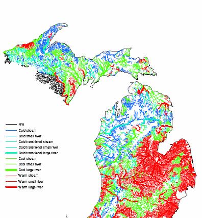
12 North Branch Kawkawlin River at Kawkawlin Grand River at Eaton Rapids Michigan rivers naturally have different flow regimes, and thus different habitat conditions, biological communities, sensitivity to disturbance, and potential for fishery management Platte River at Haze Rd
13 The Water Withdrawal Assessment Process Feeds Supports Groundwater Stream Flow Fish Populations Three Models Interact within the impact assessment model Withdrawal Model - How much water is in the aquifer, is being withdrawn, and from where and how it will affect stream flow Streamflow Model - How much water is flowing in the stream during summer low flow periods Fish Impact Model - What fish are in the stream and what is the likely effect of removing water on those groups of fish
14 Characteristics of the Withdrawal Model Distance Matters A well adjacent to a river will very quickly get water either from water that would have gone to the river or directly from the river A well farther from a river will get more water from storage and require a longer time to affect the stream Geology and Soil Matters Clay soils are tight and water does not move easily Sandy soils are porous and water flows quickly
15 The Streamflow Model Need to Know How Much Flow is in any Stream Segment Index flow ; ; low flow period in the year Look at the segments where we know the flow (147 stream gauges in the State) and extrapolate these to the streams that are not gauged Major Factors Used Drainage Basin Size Forest Cover Geology and Soils Precipitation
16 Major Factors in the Analysis The geographic database contains info for 11,000 distinct watersheds and streams Info on watershed location, size, geology; and on stream flow, temperature, and fish populations Resulting maps closely match field experiences
17 Yield (cfs/sq. mi)
18 Fish Response Model What fish populations live where in the streams of the State and how do they respond to flow reductions in the summer (at low flow) Two Key Issues to Review Defining Stream Types and Characteristic Fish Populations Defining Functional Impairment to Characteristic Fish Populations due to water withdrawals
19 We grouped Michigan streams into types and developed response models using an average of ~ 20 specific segments per type Cold 20 Cold Sm Rivers X Cold Trans Cool Warm 20 Warm Streams Streams Sm Rivers Lg Rivers
20
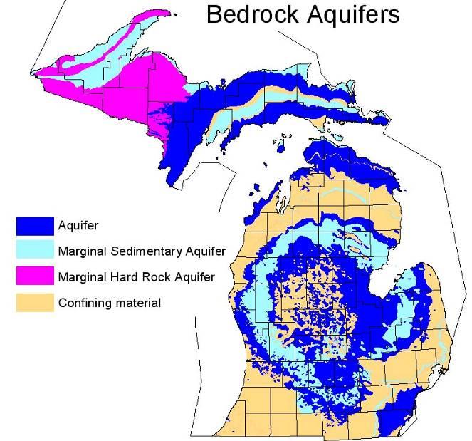
 brook trout brown trout hornyhead chub smallmouth bass mottled sculpin rock bass")

21 Low-Flow Yield (m 3. s -1. km -2 ) brook trout brown trout hornyhead chub smallmouth bass mottled sculpin rock bass yellow perch brook stickleback white sucker creek chub Each Species has a range of flow that it prefers or thrives in burbot black bullhead northern pike walleye logperch silver redhorse freshwater drum Catchment Area (km 2 )
22 Score vs. relative density - All species 3 Characteristic Thriving Relative density 2 1 Below state median Above state median 2X state median Score Relative density = site density / species' median density statewide (7000 species predictions / 183 sites)
23 What Can the Fish Curves Tell Us About Functional Impairment? Characteristic species abundance Characteristic species remaining Thriving species thriving Proportion Proportion of flow removed
24 Interpretive criteria from Davies and Jackson 2006 Baseline or existing condition Some density changes in fish Some replacement of sensitive species Proportion Characteristic species abundance Characteristic species remaining Thriving species thriving Notable replacement by tolerant species Tolerant species dominant; ecological functions altered Severe alteration of ecological structure and function Proportion of flow removed
25 Developed Fish Curves (Response Models) for Each Major Stream Type Cold Trans Cool Warm Streams Sm Rivers Lg Rivers
26 1 0.8 Interpreting the Fish Curves 80% 90% Proportion A B C D Characteristic Fish 0.2 Gradient of increasing risk Thriving Fish Proportion of index flow removed Adverse Resource Impact
27 Water Withdrawal Surface Water 100% removed from stream Ground Water Impact on stream can be less than 100% Impact can include nearby streams Impact can be spread over a relatively large area
28 Relative availability of surface water: low high
29

30 Relative availability of water when include bedrock aquifers: low high
31 The Water Withdrawal Assessment Process This is the process that the user goes though to see whether the proposed withdrawal is OK or is likely to cause an adverse effect on fish populations Screening Tool The Automated Analysis within the model based on general, state-wide data for a given withdrawal Site Specific Analysis Same process as above but using site-specific specific data on flow, geology or fish
32 Implementation
33 Date 2/28/2006 ARI standard: narrative Presumed no ARI: 1320 feet away from Trout Stream > 150 feet deep Applies to: Trout Streams Narrative: Shall not functionally impair a stream s ability to support characteristic fish populations.
34 Date 2/28/2008 ARI standard: narrative Presumed no ARI: 1320 feet away from Trout Stream > 150 feet deep Applies to: all streams Narrative: Shall not functionally impair a stream s ability to support characteristic fish populations.
35 Date 7/9/2008 ARI standard: narrative Presumed no ARI: 1320 feet away from all streams > 150 feet deep Applies to: all streams Narrative: Shall not functionally impair a stream s ability to support characteristic fish populations.
36 Date 2/1/2009 ARI standard: quantitative Presumed no ARI: 1320 feet away from all streams > 150 feet deep Applies to: all streams Quantitative: Withdrawal limited to percent reduction of Index Flow as specified in legislation (max 25%).
37 Date 7/9/2009 ARI standard: quantitative Presumed no ARI: Zone A or B in WWAT DEQ site specific review Applies to: all streams Quantitative: Withdrawal limited to percent reduction of Index Flow as specified in legislation (max 25%).
38 Requirements that Large Capacity Withdrawals (LCW) not cause an Adverse Resource Impact (ARI) Date 2/28/2006 2/28/2008 7/9/2008 2/1/2009 7/9/2009 ARI standard: narrative narrative narrative quantitative quantitative Presumed no ARI: 1320 feet away from 1320 feet away from 1320 feet away from 1320 feet away from Zone A or B in WWAT Trout Stream Trout Stream all streams all streams > 150 feet deep > 150 feet deep > 150 feet deep > 150 feet deep DEQ site specific review Applies to: Trout Streams all streams all streams all streams all streams Narrative: Shall not functionally impair a stream s ability to support characteristic fish populations. Quantitative: Withdrawal limited to percent reduction of Index Flow as specified in legislation (max 25%).
39 Registration Requirement New or increased > 100,000 gpd capacity Same as 2006 legislation New requirement: Demonstrate no ARI Screening tool or site-specific specific review 18 months to begin withdrawal

40 Zone A Zone B Zone C Zone D Zones are set by law Numerical values are different for each stream type
41 Zone A Withdrawal Register and proceed
42 Zone B Withdrawal Register and proceed Cold-transition system: site-specific specific review required DEQ notification: groups that have requested notification, such as: conservation district, regional planning agency
43 Zone C Site-specific review required Certify use of environmentally sound and economically feasible conservation measures DEQ notifies: large quantity users (of the same water source); and local governments and groups that have requested notification.
44 Zone D Site-specific review required Cannot proceed if confirmed in Zone D Potential for preventative measures
45 Triggers: Permitting > 2 million gpd capacity > 1 million gpd capacity in Zone C Use of preventative measure Transfer of > 100,000 gpd from watershed of one Great Lake to another Exemption: Less than 2 million gpd use over 90 day average Public involvement process
46 Permitting Standard No ARI Returned, less consumptive use, to source watershed In compliance with local, state and federal laws Reasonable under Michigan common law Certified compliance with conservation measures Will not violate public or private rights of Michigan water law
47 Annual Reporting Requirement Volume withdrawn on annual and monthly basis Source and location Consumptive use Beginning 2010: Acknowledge review of conservation measures
48 Transition Tool available for testing: 10/1/08 Begin accounting of withdrawals: 10/1/08 Effective date of new ARI standard: 2/1/09 Account for cumulative impacts: 2/1/09 Required use of tool for registration: 7/9/09
49 Specific Uses Municipal community system: ARI if no feasible and prudent alternative location Bottled Water: Permit threshold dropped to 200,000 gpd. No ARI Reasonable use Protect riparian rights Address hydrologic impacts Public involvement process
50 Future Directions Water User Committees Develop protective model for lakes Assessment of impacts to other ecological features
Water Issues Large Scale Water Use Assessment Tool MBG Horticulture Day
 Water Issues Large Scale Water Use Assessment Tool MBG Horticulture Day Steve Miller Biosystems and Agricultural Engineering, MSU With slides from Paul Seelbech, MDNR Lyndon Kelley, MSUE Jon F. Bartholic
Michigan State University
 Distinguished Senior Research Specialist - Remote Sensing & GIS Research and Outreach Services, Dept. of Geography - Institute of Water Research 1 / 102 Objectives Why is the Water Wonderland regulating
Water Sustainability: Toward A Common Understanding Michigan Case Study
 Water Sustainability: Toward A Common Understanding Michigan Case Study November 2, 28 University of Minnesota, St. Paul Campus Howard W. Reeves, USGS Michigan Water Science Center U.S. Department of the
Using Your Computer for Water Withdrawal Planning and Groundwater Mapping
 Michigan s Water Withdrawal Assessment Tool An Overview Distinguished Senior Research Specialist Michigan State University Dept. of Geography And Institute of Water Research 1 / 29 Act 451 of 1994 (Natural
Michigan Water Use Requirements 2011 Update
 Michigan Water Use Requirements 2011 Update Lyndon Kelley MSU Extension/Purdue University Irrigation Management Educator 269-467-5511 kelleyl@msu.edu Steve Miller MSU Extension Irrigation Management Specialist
Streamflow Depletion by Pumping Wells and the Michigan Water- Withdrawal Assessment Process
 Streamflow Depletion by Pumping Wells and the Michigan Water- Withdrawal Assessment Process Howard W. Reeves, USGS Michigan-Ohio Water Science Center Water in the West, Groundwater Data Workshop Stanford
The DNR is charged with managing waters resources to assure an adequate and sustainable supply for multiple uses.
 The DNR is charged with managing waters resources to assure an adequate and sustainable supply for multiple uses. Minnesota Laws 2015, chapter 4, article 4, directed the Department of Natural Resources
Role of NHD/NHDPlus for environmental-flow based legislation in Michigan and environmental-flow framework for the US Great Lakes Basin
 Role of NHD/NHDPlus for environmental-flow based legislation in Michigan and environmental-flow framework for the US Great Lakes Basin Howard W. Reeves, USGS Michigan-Ohio Water Science Center Paul W.
Environmental Science and Policy Program. Environment at MSU: WATER. Networking for Environmental Researchers
 Environmental Science and Policy Program Environment at MSU: WATER Networking for Environmental Researchers Presented by Dr. Jon F. Bartholic, Director Friday, October 3, 3-4:30 p.m., Corniche Room, Kellogg
CVC & TRCA Water Balance Guidelines for the Protection of Natural Features
 CVC & TRCA Water Balance Guidelines for the Protection of Natural Features Scott Sampson, CVC Supervisor Natural Heritage Program Laura Del Giudice, TRCA Senior Planning Ecologist April 26, 2012 Outline
Jan Moryk, Project Manager, Environmental Monitoring and Data Management Section, TRCA
 Distribution of Brook Trout in the TRCA Jurisdiction and what Legislation, Policies, and Guidelines do Conservation Authorities have at their disposal to Protect Brook Trout Habitat Jan Moryk, Project
From the cornbeltto the north woods; understanding the response of Minnesota. Chris Lenhart Research Assistant Professor BBE Department
 From the cornbeltto the north woods; understanding the response of Minnesota watersheds to climate change Chris Lenhart Research Assistant Professor BBE Department 1. Background Differential response of
Jan Moryk, Project Manager, Environmental Monitoring and Data Management Section, TRCA
 Distribution of Brook Trout in the TRCA Jurisdiction and what Legislation, Policies, and Guidelines do Conservation Authorities have at their disposal to Protect Brook Trout Habitat Jan Moryk, Project
Virtual Water Accounting: A New Framework for Managing Great Lakes Water Resources
 Virtual Water Accounting: A New Framework for Managing Great Lakes Water Resources Alex Mayer, Michigan Technological University Ben Ruddell, Arizona State University Stanley Mubako, University of Texas,
Science Supporting Policy: The Case For Flow Quantity
 MassDEP Water Management Program Science Supporting Policy: The Case For Flow Quantity Integrating Water Resources Management UMASS Conference April 8, 2008 Overview Human impact on streamflow and aquatic
Ottawa County Water Resources Study Phase 2
 Ottawa County Water Resources Study Phase 2 Overview David P. Lusch, Ph.D. Department of Geography and Institute of Water Research Michigan State University 1 / 24 Ottawa County Planning and Performance
Establishing Environmental Flows for California Streams. Eric Stein Southern California Coastal Water Research Project
 Establishing Environmental Flows for California Streams Eric Stein Southern California Coastal Water Research Project What Do We Know About the Status of Flows Statewide? First comprehensive study recently
Michigan Department of Environmental Quality Resource Management Division Office of Oil, Gas, and Minerals
 Michigan Department of Environmental Quality Resource Management Division Office of Oil, Gas, and Minerals DEQ Mission Statement The Michigan Department of Environmental Quality promotes wise management
Magino Project Environmental Impact Statement. Technical Support Document Draft Fish Habitat Compensation Plan
 Magino Project Environmental Impact Statement Technical Support Document 20-14 Rev. No. Revision Date Approved 0 Document issued for EIS Table of Contents SECTION 1.0 INTRODUCTION... 1 SECTION 2.0 BACKGROUND...
Cold Waters Temperature Assessment across the Northeast
 Cold Waters Temperature Assessment across the Northeast March 23, 2012 Jennifer M. Jacobs, Erik Carlson, and Emily Carlson Environmental Research Group Department of Civil Engineering University of New
Rick Henderson, Field Operations Supervisor DEQ Office of Oil, Gas, and Minerals
 Rick Henderson, Field Operations Supervisor DEQ Office of Oil, Gas, and Minerals 1 Contamination Conservation Uses Remediation Protection Groundwater Protection DEQ Supervisor of Wells Part 615 Oil and
Watershed Management Area Recommendations for NJ Water Policy
 Watershed Management Area Recommendations for NJ Water Policy Presenters: William Kibler, Director of Policy, Raritan Headwaters Association Bob Kecskes, Freelance Environmental Consultant, retired NJDEP
Instream Flow Protection Efforts in Pennsylvania
 Instream Flow Protection Efforts in Pennsylvania Leroy M. Young Pennsylvania Fish and Boat Commission Glossary Instream use - any use of water that does not require a diversion or withdrawal from the original
Bureau of Drinking Water & Groundwater Wisconsin DNR
 Groundwater Management in Wisconsin: Current Status & Gaps Eric Ebersberger and Larry Lynch Bureau of Drinking Water & Groundwater Wisconsin DNR October 1, 2012 High Capacity Wells Wells, individually
APPENDIX 8. NORTHERN GROUND ELECTRODE LINE WATERCOURSE CROSSING ASSESSMENT BOOKLETS
 APPENDIX 8. NORTHERN GROUND ELECTRODE LINE WATERCOURSE CROSSING ASSESSMENT BOOKLETS Aquatic Environment November 2011 Bipole III Transmission Project Construction Camp CC1 Location Datum: NAD 83 UTM: Zone:
Current Applicant s Handbook Wetland Criteria No Harm Standards. Narrative Standard All categories. Assessment
 District 40X-2.301 Exclusions SFWMD SJRWMD harm to s or waters; harmful 1) Isolated s ½ acre or less (some caveats) 2) Wetlands be impacts by an ERP or SWM; 3) constructed waterbodies 4) s & waters that
Impacts of Permit-Exempt Wells
 Impacts of Permit-Exempt Wells Dave Nazy, LHG August 24, 2018 1 Impacts of Permit-Exempt Wells Introduction ESSB 6091 Example Impacts Calculation Basin Estimate & 20-year Projections Offsetting Impacts
Management Objectives and Targets
 Management Objectives and Targets As part of the Yampa River Stream Management Plan, the community of Steamboat Springs developed management objectives for the reach of the Yampa River near Steamboat Springs.
Warm Springs Hydro LLC 5203 South 11 th East Idaho Falls, ID
 Warm Springs Hydro LLC 5203 South 11 th East Idaho Falls, ID 83404 208-522-8069 ted@tsorenson.net September 26, 2013 Elizabeth A.O. Moats Oregon Department of Fish and Wildlife 107 20 th Street La Grande,
Comments from 4/12 - Draft Responses
 Comments from 4/12 - Draft Responses Introduction The following document covers the proposed path forward and responds to questions and comments from the April 12, 2017, Stakeholder Meeting. Please review
The Grand River. Overview of Water Quality and Ecological Health. Daniel M. O Keefe, Ph.D. Michigan Sea Grant MSU Extension
 The Grand River Overview of Water Quality and Ecological Health Daniel M. O Keefe, Ph.D. Michigan Sea Grant MSU Extension How does surface water quality in Ottawa County compare to other areas of the state?
Regulation of Groundwater
 Regulation of Groundwater November 10, 2016 Presented by: Carl A. Sinderbrand Axley Brynelson, LLP Legal Framework for Water Regulation in Wisconsin Public Trust Doctrine... the river Mississippi and the
Sobhalatha Kunjikutty
 Sobhalatha Kunjikutty Conservation Ontario _ Climate Change Workshop February 9, 2011 Overview Identify Risk Risk Evaluation Primary & Secondary Impacts Resource Management Implications Adaptive Response
NC Water Resources Planning April 4, Tom Fransen. North Carolina Division of Water Resources 1
 NC Water Resources Planning April 4, 2011 Tom Fransen North Carolina Division of Water Resources 1 Water links us to our neighbor in a way more profound and complex than any other. -John Thorson 1/18/2011
Mapping and Understanding YOUR LAKE S WATERSHED By: Tony Groves, Pam Tyning, and Tory Meyers Water Resources Group, Progressive AE
 By: Tony roves, Pam Tyning, and Tory Meyers Water Resources roup, Progressive A What is a Watershed? A watershed is the land area surrounding a lake from which water drains to the lake. The imaginary line
2300A Pesticide General Permit
 WQ Permitting and Program Development 2300A Pesticide General Permit Feb. 22, 2017 Portland Beth Moore Oregon Department of Environmental Quality Today s Presentation Topics Pesticide general permit background
ALABAMA S FUTURE WITHOUT SUSTAINABLE WATER RESOURCES? NOT ON OUR WATCH. Marlon Cook
 ALABAMA S FUTURE WITHOUT SUSTAINABLE WATER RESOURCES? NOT ON OUR WATCH Marlon Cook Geological Survey of Alabama Groundwater Assessment Program Sustainable Water Resources Sustainable Yield: The water extraction
Environmental Resource Inventories. What are ERIs? Significance of information How to use them
 Environmental Resource Inventories What are ERIs? Significance of information How to use them Environmental Resource Inventory - ERI Compiled by the environmental commission Information about the natural
Past Studies in the Clearwater River Watershed. Past Studies MPCA Lost River Investigation. Past Studies Clearwater River Nonpoint Study
 Past Studies in the Clearwater River Watershed March 2007 Stakeholder Advisory Group Meeting Clearwater Nonpoint Study Biological studies Wild rice paddy water quality Clearwater Lake Water Quality Model
INSTREAM FLOW GUIDELINES AND PROTECTION OF GEORGIA S AQUATIC HABITATS
 INSTREAM FLOW GUIDELINES AND PROTECTION OF GEORGIA S AQUATIC HABITATS Mary M. Davis AUTHOR Aquatic Ecologist, The Nature Conservancy, 133 West Peachtree Street, Suite 41, Atlanta, Georgia 339 REFERENCE
F7 Stream Reach Summary
 F7 Stream Reach Summary Study Reach: F7, Fraser River - Ranch Creek confluence downstream to Canyon below Strawberry Road. Reach Description: Approximate channel length: 1 ½ miles, approximate channel
WATER MANAGEMENT PLAN FOR UNCONVENTIONAL GAS WELL DEVELOPMENT
 COMMONWEALTH OF PENNSYLVANIA Example Format DEPARTMENT OF ENVIRONMENTAL PROTECTION OFFICE OF OIL AND GAS MANAGEMENT WATER MANAGEMENT PLAN FOR UNCONVENTIONAL GAS WELL DEVELOPMENT APPLICANT AND PLAN COVERAGE
3.4 AQUATIC ECOSYSTEMS AND FISH SPECIES
 3.4 AQUATIC ECOSYSTEMS AND FISH SPECIES The following section supplements the analysis found in Chapter Three, Section 3.4 - Aquatic Ecosystems and Fish Species of the Draft EIS on page 3.59, Impacts Related
ICELANDIC RIVER / WASHOW BAY CREEK INTEGRATED WATERSHED MANAGEMENT PLAN STATE OF THE WATERSHED REPORT CONTRIBUTION SURFACE WATER HYDROLOGY REPORT
 ICELANDIC RIVER / WASHOW BAY CREEK INTEGRATED WATERSHED MANAGEMENT PLAN STATE OF THE WATERSHED REPORT CONTRIBUTION SURFACE WATER HYDROLOGY REPORT Disclaimer: The hydrologic conditions presented in this
Impacts of 2015 Drought on Streamflow in the Columbia River Basin
 Impacts of 2015 Drought on Streamflow in the Columbia River Basin Chris Konrad US Geological Survey Tacoma, WA May 11, 2016 1 Overview of USGS Investigation Western US had low snowpack, warm temperatures,
Water for All, Now and Into the Future: Water Quantity in Wisconsin. A report by the Sierra Club-John Muir Chapter
 Water for All, Now and Into the Future: Water Quantity in Wisconsin A report by the Sierra Club-John Muir Chapter Table of Contents Background The Importance of Water Quantity Water Use in Wisconsin Excessive
Portage Lake Hubbard County
 Prepared in cooperation with the Minnesota Department of Natural Resources Minnesota Lake ID: 9- Area: acres Watershed Area: 6,7 acres Ecoregion: Northern Lakes and Forests (NLF) Portage Lake Hubbard County
Information Request 37
 Information Request 37 Information Request 37 37-1 Response to Information Request 37 Response to Information Requests 37a Response to Information Requests 37b 37-3 37-5 Federal Review Panel Information
STATE OF MICHIGAN DEPARTMENT OF NATURAL RESOURCES FISHERIES DIVISION RESEARCH REPORT 2089
 DNR DEPARTMENT OF NATURAL RESOURCES MICHIGAN STATE OF MICHIGAN DEPARTMENT OF NATURAL RESOURCES RR2089 November 2008 A Regional-scale Habitat Suitability Model to Assess the Effects of Flow Reduction on
Integrated Watershed Management Plan
 mighty peace watershed alliance Integrated Plan SUMMARY What is the Plan? The Mighty Peace Alliance (MPWA) supports the three goals of Alberta s Water for Life Strategy: safe secure drinking water, healthy
CENTRAL ASSINIBOINE INTEGRATED WATERSHED MANAGEMENT PLAN SURFACE WATER HYDROLOGY REPORT
 CENTRAL ASSINIBOINE INTEGRATED WATERSHED MANAGEMENT PLAN SURFACE WATER HYDROLOGY REPORT Planning Area Boundary: The Central Assiniboine planning area covers the reach of the Assiniboine River from just
Green River Basin Plan Executive Summary
 Green River Basin Plan Executive Summary December 2010 Prepared for: Wyoming Water Development Commission Basin Planning Program Prepared by: WWC Engineering AECOM ERO Resources Corp. Table of Contents
Environmental Flows and Habitat Suitability Index Assessments
 Environmental Flows and Habitat Suitability Index Assessments Latornell Symposium November 17, 2015 T2F Sam Bellamy The Problem Hydrologists, hydrogeologists and engineers often inform on the hydrologic
Great Lakes-St. Lawrence River Basin Water Resources Compact Water Conservation and Efficiency Annual Program Review.
 Great Lakes-St. Lawrence River Basin Water Resources Compact Water Conservation and Efficiency Annual Program Review November 21, 2012 State of Michigan This Water Conservation and Efficiency Annual Program
Song Lake Water Budget
 Song Lake Water Budget Song Lake is located in northern Cortland County. It is a relatively small lake, with a surface area of about 115 acres, and an average depth of about 14 feet. Its maximum depth
Have agricultural management practices (AMPs) improved water quality?: A case study in Sugar Creek
 improved water quality?: A case study in Sugar Creek") June 8, 212 Have agricultural management practices (AMPs) improved water quality?: A case study in Sugar Creek Jeff Frey U.S. Geological Survey U.S. Department of the Interior U.S. Geological Survey National
June 8, 212 Have agricultural management practices (AMPs) improved water quality?: A case study in Sugar Creek Jeff Frey U.S. Geological Survey U.S. Department of the Interior U.S. Geological Survey National
MiCorps 101. Presented by Paul Steen. & MiCorps Staff
 MiCorps 101 Presented by Paul Steen & MiCorps Staff MiCorps Team Bill Dimond Laura Kaminski Anne Sturm Dina Klemens Paul Steen, Ph.D. Jason Frenzel Scott Brown Jean Roth Jo Latimore, Ph.D. Together, we
Ecological Limits of Hydrologic Alteration in Dane County Streams
 Fish Community Status Ecological Limits of Hydrologic Alteration in Dane County Streams Final Report April 24, 2014 Matthew Diebel, Aaron Ruesch, and Diane Menuz Wisconsin Department of Natural Resources
Predicting Natural Background Phosphorus in Wisconsin Streams Using a Geostatistical Model. Shupryt, M.P. and Ruesch A.S.
 Predicting Natural Background Phosphorus in Wisconsin Streams Using a Geostatistical Model Shupryt, M.P. and Ruesch A.S. Background: Numeric Nutrient Criteria 6 States with one aquatic media with numeric
Information for EFSAB:
 Information for EFSAB: Stream-ecology and flow relationships based on our ACF research Transferability of species preferences Defensibility of ACF work in context of controversy Mary Freeman USGS Patuxent
Lecture 9A: Drainage Basins
 GEOG415 Lecture 9A: Drainage Basins 9-1 Drainage basin (watershed, catchment) -Drains surfacewater to a common outlet Drainage divide - how is it defined? Scale effects? - Represents a hydrologic cycle
Environmental Flows Allocation Process in Texas. Kevin Mayes Texas Parks and Wildlife Department March 2010
 Environmental Flows Allocation Process in Texas Kevin Mayes Texas Parks and Wildlife Department March 2010 Senate Bill 3-2007 Environmental Flow Regime A schedule of flow quantities that reflects seasonal
The following potential environmental receptors and impacts form the basis of TRCA s review under Ontario Regulation 166/06 and the Fisheries Act:
 TRCA Technical Guidelines for the Development of Environmental Management Plans for Dewatering September 2013 Rationale: The Technical Guidelines for the Development of Environmental Management Plans for
Hood River Basin Study
 Hood River Basin Study Agenda 1). Goals 2). Partners 3). Study Overview 4). Recommendations Goals Evaluate: 1. Current and future water demands 2. Water conservation opportunities 3. Groundwater resources
Advice to decision maker on coal mining project
 . Advice to decision maker on coal mining project IESC 2015-063: West Muswellbrook Project New Development Requesting agency The New South Wales Mining and Petroleum Gateway Panel Date of request 27 January
Issue paper: Aquifer Water Balance
 Issue paper: Aquifer Water Balance 1. Introduction And Background 1.1. Purpose and Scope The population in Kitsap County has grown rapidly in recent years and is expected to increase substantially in the
Bonsall Creek Watershed Management Plan Gap Analysis
 Bonsall Creek Watershed Management Plan Gap Analysis March 2015 Prepared by Gap Analysis Introduction The Bonsall Creek Watershed Management Plan provides a vision for water use in the watershed, including
The following potential environmental receptors and impacts form the basis of TRCA s review under Ontario Regulation 166/06 and the Fisheries Act:
 Interim TRCA Technical Guidelines for the Development of Environmental Management Plans for Dewatering September 2013 Rationale: The Technical Guidelines for the Development of Environmental Management
Water Use Legislation
 Water Use Legislation 2004 Irrigation Meetings Note to presenters: Handout materials are available at http://www.kbs.msu.edu/mgsp Copies of PA 177 and PA 148 are available at http://www.michiganlegislature.org
Hello my name is Joy Loughry and I am with the groundwater technical unit of the Minnesota department of natural resources. Today I am going to talk
 Hello my name is Joy Loughry and I am with the groundwater technical unit of the Minnesota department of natural resources. Today I am going to talk about how the state of Minnesota manages its Water resources
Water Allocation. Permit Program 1
 Water Allocation Permit Program 1 WATER RIGHTS ACT OF 1939 No implementing regulations only guidance document 392-2130-001 issued 1992 and updated draft guidance issued September 7, 2012. Applicability
CUMULATIVE IMPACT ANALYSIS: A SIMPLE MODEL FOR LOCAL GOVERNMENT RESERVOIRS AND WITHDRAWALS IN GEORGIA
 CUMULATIVE IMPACT ANALYSIS: A SIMPLE MODEL FOR LOCAL GOVERNMENT RESERVOIRS AND WITHDRAWALS IN GEORGIA Nolton G. Johnson AUTHOR: Chief, Water Resources Branch, Georgia Environmental Protection Division,
Boardman River Townships Project EAST BAY TOWNSHIP. WATER QUALITY ACTION PLAN Fall 2009
 Boardman River Townships Project EAST BAY TOWNSHIP WATER QUALITY ACTION PLAN Fall 2009 Partners: The Watershed Center Grand Traverse Bay Northwestern Michigan College - Great Lakes Water Studies Institute
3.3 Paw Paw River, Michigan
 Conservancy will be applying the results of this assessment (and conducting some additional assessment using the stream power tool) to select target reaches for restoration using 1) channel restoration
Community. Restoration. Prevention.
 Community. Restoration. Prevention. Truckee Wetlands Restoration Project Thank you to our Funders Donors to the OUR VALUES PARTNERSHIPS ECOLOGICALLY SOUND ECONOMICS Truckee River Watershed Council May
Great Lakes Coastal Wetland Monitoring: Support of Restoration Across the Basin
 : Support of Restoration Across the Basin Matthew J. Cooper University of Notre Dame, Notre Dame, IN Presentation Outline Quality control and assurance Importance of basin wide monitoring Examples of our
Wapato Access Feasibility Study
 Wapato Access Feasibility Study David Gorman, PE Michael Rounds, PE August 5, 2011 Lower Columbia River Estuary Partnership (LCREP) Non-profit two state public-private initiative Primary Responsibility:
CHAPTER FIVE Runoff. Engineering Hydrology (ECIV 4323) Instructors: Dr. Yunes Mogheir Dr. Ramadan Al Khatib. Overland flow interflow
 Instructors: Dr. Yunes Mogheir Dr. Ramadan Al Khatib. Overland flow interflow") Engineering Hydrology (ECIV 4323) CHAPTER FIVE Runoff Instructors: Dr. Yunes Mogheir Dr. Ramadan Al Khatib Overland flow interflow Base flow Saturated overland flow ١ ٢ 5.1 Introduction To Runoff Runoff
Engineering Hydrology (ECIV 4323) CHAPTER FIVE Runoff Instructors: Dr. Yunes Mogheir Dr. Ramadan Al Khatib Overland flow interflow Base flow Saturated overland flow ١ ٢ 5.1 Introduction To Runoff Runoff
Defining Flow Needs for Pennsylvania s Riverine Ecosystems Tara Moberg. Wednesday, Nov. 7, 2012 WRA of the Delaware Basin s 53 RD Annual Conference
 Defining Flow Needs for Pennsylvania s Riverine Ecosystems Tara Moberg Wednesday, Nov. 7, 2012 WRA of the Delaware Basin s 53 RD Annual Conference Presentation Summary Recent developments in instream
4. What is Item A called? a. Eckman dredge b. Secchi disk c. Van Dorn sampler d. Ponar sampler
 Envirothon Questions for AQUATICS station April 24, 2013 1. Eutrophication often results in large fish kills. What is the major cause of these fish kills? a. Oxygen has been depleted due to the decay of
Hood River Basin Study
 Hood River Basin Study Agenda 1). Goals 2). Partners 3). Study Overview 4). Recommendations Goals Evaluate: 1. Current and future water demands 2. Water conservation opportunities 3. Groundwater resources
How Much is Too Much? Effects-Based versus Stressor-Based Benchmarks and Thresholds and Some Examples from the Elk Valley in the East Kootenays
 How Much is Too Much? Effects-Based versus Stressor-Based Benchmarks and Thresholds and Some Examples from the Elk Valley in the East Kootenays Outline 1. Effects-based versus stressor-based indicators,
Red Rock Lake: A Path Forward
 University of Minnesota Morris Digital Well University of Minnesota Morris Digital Well Center for Small Towns 6-2016 Red Rock Lake: A Path Forward Colette Millard Student - University of Minnesota, Morris
Hydroecological tool: enhancements and results. enhancements and results. Marci Meixler. Project partners: Sponsored by:
 Hydroecological tool: Marci Meixler Sponsored by: Project partners: Motivation Great Lakes Charter Annex establish uniform, regional protections for Great Lakes waters ensure that authority over the Lake
Water and Wisconsin Agriculture: Reducing Withdrawals and Increasing Efficiency
 Water and Wisconsin Agriculture: Reducing Withdrawals and Increasing Efficiency Bob Smail Water Use Section Wisconsin DNR Presented March 11, 2014 Wisconsin Land and Water Conservation Association Meeting
Grand Traverse Bay Watershed Protection Plan:
 Grand Traverse Bay Watershed Protection Plan: An Overview Sarah U Ren Program Director The Watershed Center 231-935-1514, suren@gtbay.org What is a Watershed? A watershed is an area of land that captures
Occurrence of Iron in Surface Waters of the Upper St. Johns River Basin
 Occurrence of Iron in Surface Waters of the Upper St. Johns River Basin Prepared by Florida Department of Environmental Protection Bureau of Watershed Management Ground Water Protection Section December
Watershed Analysis for Mendocino Redwood Company s Ownership in the Gualala River Watershed
 Watershed Analysis for Mendocino Redwood Company s Ownership in the Gualala River Watershed INTRODUCTION This report presents the results of a watershed analysis performed by Mendocino Redwood Company
Natural Gas Development in the Susquehanna River Basin. Jennifer Hoffman September 29, 2010 Pittsburgh, PA
 Natural Gas Development in the Susquehanna River Basin Jennifer Hoffman September 29, 2010 Pittsburgh, PA Susquehanna River Basin The Basin 27,510-square-mile watershed Comprises 43 percent of the Chesapeake
Wickes Manufacturing TCE Plume Site Mancelona, Michigan
 Wickes Manufacturing TCE Plume Site Mancelona, Michigan December 2017 What is TCE? Trichloroethylene (TCE) Common Industrial Solvent Known Human Carcinogen Federal and State Safe Drinking Water of 5 µg/l
June 2008 LYNDE CREEK WATERSHED EXISTING CONDITIONS REPORT CHAPTER 10 - WATER TEMPERATURE
 June 2008 LYNDE CREEK WATERSHED EXISTING CONDITIONS REPORT CHAPTER 10 - WATER TEMPERATURE TABLE OF CONTENTS 1.0 INTRODUCTION...3 2.0 STUDY AREA AND SCOPE...5 3.0 METHODOLOGY...7 4.0 FINDINGS...7 4.1 Lynde
A landscape perspective of stream food webs: Exploring cumulative effects and defining biotic thresholds
 A landscape perspective of stream food webs: Exploring cumulative effects and defining biotic thresholds Objectives To better understand how stream food webs are embedded in their landscapes To quantify
GROUNDWATER. Water Resources of NYS: The Nature of its Underground Water. Composite Groundwater Environment. Groundwater Resources of NYS
 Water Resources of NYS: The Nature of its Underground Water Prof. Anthony Grande AFG 2014 1 GROUNDWATER Groundwater - water occupying the pore spaces and cracks in rocks and unconsolidated material. The
Maine s Land Use Regulations and Erosion Control Techniques
 Maine s Land Use Regulations and Erosion Control Techniques Protecting Maine s Air, Land and Water Colin Clark 441-7419 colin.a.clark@maine.gov Tom Gilbert 441-8031 thomas.gilbert@maine.gov Jim Rodrigue
Hydraulic Fracturing for Shale Gas Production: Practices & Progress
 Hydraulic Fracturing for Shale Gas Production: Practices & Progress David P. Regalbuto, CPG MWEA Annual Conference Boyne Mountain Resort June 27, 2012 Objectives Dispel misconceptions Clarify potential
Recharge Lake/Wetland: Generalized Monitoring Strategy
 General Hydrologic Characteristics of Recharge Lakes & Wetlands The primary sources of water for recharge lakes and wetlands are direct precipitation and surface runoff. The lake stage of a recharge lake
Unify efforts to address water resources for the Big Sky area and surrounding zone of influence in three co-equal water resources focus areas:
 EXECUTIVE SUMMARY The Big Sky Sustainable Water Solutions Forum (Water Forum) is a community-based, collaborative approach building a unified vision for future Big Sky water resources management to maintain
ORIGINAL EFFECTIVE DATE
 APPROVED AMENDMENTS: Effective date Briefing Note Summary of Changes: /Approval March 1, 2014 January 2014 New policy June 15, 2015 June 15, 2015 Administrative changes, additional detail for greater clarity
Municipal Stormwater Management Plan Prepared For The Borough of Cape May Point By Van Note-Harvey Associates VNH File No.
 Municipal Stormwater Management Plan Prepared For The Borough of Cape May Point By Van Note-Harvey Associates 2005 VNH File No. 35317-210-21 Table of Contents Introduction... 3 Goals... 3 Storm water Discussion...
FREQUENTLY ASKED QUESTIONS GUELPH/GUELPH-ERAMOSA TIER 3 WATER BUDGET AND LOCAL AREA RISK ASSESSMENT STUDY
 FREQUENTLY ASKED QUESTIONS GUELPH/GUELPH-ERAMOSA TIER 3 WATER BUDGET AND LOCAL AREA RISK ASSESSMENT STUDY Contents Overview... 3 1. What is a Tier 3 Water Budget Study?... 3 2. How does a Tier 3 Water