Watersheds and the Hydrologic Cycle
|
|
|
- Myron Williamson
- 6 years ago
- Views:
Transcription

1 Watersheds and the Hydrologic Cycle

2 The Global Hydrologic Cycle

3 Water Cycle in Florida
 River and Stream = 84000 km Largest River = Apalachicola (Q = 22 km 3 /yr = 25,000 ft 3 /s) Lake Area = 12,100 km 2 Springs ~ 30 billion L/ day (8 billion gallons) Groundwater")
4 Florida Water Facts Surface Area = 170,452 km 2 Average Rainfall = 140 cm (55 ) Total Annual Rain = 238 billion m 3 (62.6 trillion gallons) River and Stream = km Largest River = Apalachicola (Q = 22 km 3 /yr = 25,000 ft 3 /s) Lake Area = 12,100 km 2 Springs ~ 30 billion L/ day (8 billion gallons) Groundwater supplies 95% of water 24 billion L/day; 80% in S. Florida Low relief travel time for water (rainfall to sea) can be decades
5 The Hydrologic Check-Book Mass Balance Water mass is conserved Therefore: Water In = Water Out Sources Rain, Snow, Groundwater, Human Effluent Sinks Ground, River, Atmosphere, Humans Stores Wetlands, Lakes, Rivers, Soil, Aquifers
6 The Water Budget (Exam 1) INFLOW OUTFLOW P= Q + ET + G + ΔS Precipitation Surface runoff Evapotranspiration Groundwater Storage
 Infiltration to Deep Aquifer (~5 cm, though upto ~ 40 cm) Subsurface Runoff (~")
7 Annual Water Budget - Flatwoods Rainfall (~ 140 cm) Interception (~ 25 cm) Transpiration (~ 85 cm) Surface Runoff (~ 3 cm) Infiltration to Deep Aquifer (~5 cm, though upto ~ 40 cm) Subsurface Runoff (~ 22 cm)
 Surface Runoff (~ 20 cm) Infiltration to Deep Aquifer (~30 cm) Subsurface Runoff")
8 Rainfall (~ 140 cm) Annual Water Budget Ag Land Interception (~ 20 cm) Transpiration (~ 100 cm) Irrigation (~ 50 cm) Surface Runoff (~ 20 cm) Infiltration to Deep Aquifer (~30 cm) Subsurface Runoff (~ 20 cm)
 Surface Runoff (~ 50 cm) Infiltration to Deep Aquifer (~ 10 cm) Subsurface Runoff (~ 10")
9 Annual Water Budget Urban Land Rainfall (~ 140 cm) Interception (~ 20 cm) Transpiration (~ 50 cm) Surface Runoff (~ 50 cm) Infiltration to Deep Aquifer (~ 10 cm) Subsurface Runoff (~ 10 cm)

10 Changes in Internal Stores ΔStorage = Inputs Outputs Usually easy to measure (e.g., lake volume) In > Out? Out > in? In = Out? What if In measured > Out measured AND water level is falling?
 Water flows measured as volumes (m 3 /yr).")
11 Rules of Water Balances Water balance terms must be in common units (usually meters depth over the watershed area). Precipitation and ET measured in depth (m/yr) Water flows measured as volumes (m 3 /yr). Volume = Depth x Area Depth = Volume / Area
 Aridity index on the x-axis (potential ET:rain) Evaporative index on the y axis (actual")
12 An Even Simpler Water Budget Budyko Curve shows annual catchment hydrology Can neglect G and ΔS, focus on ET (P ~ ET + Q) Aridity index on the x-axis (potential ET:rain) Evaporative index on the y axis (actual ET:rain)
13 Catchment Water Balance Area = 1000 ha (10,000 m 2 per ha) Annual Measurements: Rainfall = 2 m (tipping-bucket rain gage) Surface outflow (Q) = 2,000,000 m 3 (weir) ET = 1.5 m (eddy correlation tower) Groundwater flow = 1,000,000 m 3 (wells) Assume ΔS=0
14 Budget: P= Q + ET + G + ΔS Area = 1000 ha; 1 ha = 10,000 m 2 P = 2.0 m Q = 2,000,000 m 3 /(1000 ha * 10,000 m 2 /ha) = 0.2 m ET = 1.5 m G = 1,000,000 m 3 /(1000 ha * 10,000 m 2 /ha) = 0.1 m S = = (?!)
15 Explanations Rainfall is uneven 1 rain gage may not reflect rainfall patterns Streamflow may be poorly gaged Poor measurements are usually ± 10% ET measurements may be incomplete Eddy correlation towers are usually accurate Groundwater flow is more complex Network of shallow wells is hard to implement Storage change is NOT zero Wetlands fill/drain, soils dry/wet, aquifers rise/fall
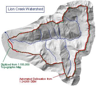
16 Watersheds A land area from which all rainfall drains to the same point. The watershed is technically the divide between two such areas (called basins)

17 Delineating Watersheds 1. Identify outlet point 2. Identify high points 3. Link high pts crossing contour lines at right-angles 3 2 1
18 High-Relief Watersheds
19 Why Watersheds? Control boundaries Water that falls either comes out the bottom or is abstracted Imagine a water budget if you weren t sure where the water was going P + Q in1 + Q in2 = Q out1 + Q out2 + ET + G 1 + G 1 + ΔS

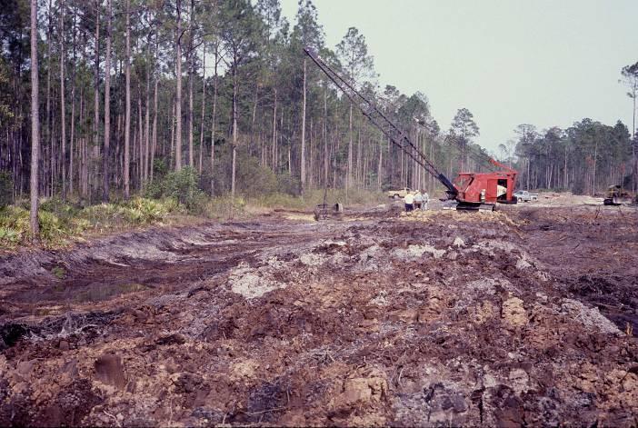
20 Experimentation Paired Watersheds What is the effect of forest management on: Water yield Sediment yield Nutrient export Water temperature Time of transport
21 Paired Watershed Response
22 Paired Watershed Study of Forest Harvest Effects on Peakflows LOGGING ROAD BUILDING Beschta et al H.J. Andrews Experimental Forest (OR)
23 Does watershed delineation work in Low-relief Delineation of boundaries hard In parts of Florida, water flows depend on: where it rained, where the wind is blowing and where people put the canals and roads National contour maps too coarse (5 ft) Roads act as flow delineators Florida?????
24 Delineating Watersheds in Florida
25 Paired Watersheds in Florida Shown that (Riekerk 1983): High intensity logging increased water yields by 250% Low intensity logging increased water yields 150% Clear cutting altered nutrient export rates All forest operations (fire?) were less than urbanization (much more on this later)
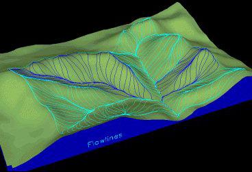
26 Stream Patterns Dendritic patterns follow Strahler Order 1 st order is unbranched 2 nd order occurs when two 1 st order reaches converge Increased order requires convergence of two reaches of the same order What are springs?
27 Network Forms Regional landform dictates shape Regional geology dictates drainage density Regional climate (rainfall) dictates density and maturation rate

28 Stream Order Distribution
29 Watershed Networks Mass transport is optimal at minimum work Reach and network scales at the SAME time Necessary conditions for dendritic drainage Minimal energy expenditure at any link in the network Equal Energy Expenditure per unit area Minimum Energy Expenditure in the Network as a whole Rodriguez-Iturbe et al. (1992) - WRR
30 Water Convergence Across Scales - St Johns River Basin - Ocklawaha River Basin - Orange Creek Sub-Basin - Newnans Lake Watershed - Hatchett Creek Watershed - ACMF Hillslope - Lake Mize catchment

31 Lake Mize hillslope Conference Center Lake Mize

32 Austin Cary Forest Lake Mize Hatchett Creek

33 Hatchet Creek Catchment Hatchett Creek

34 Santa Fe Swamp Newnans Lake Hatchett Creek Watershed Gainesville Lake Forest Creek Newnans Lake Prairie Creek

35 Orange Creek Basin Paynes Prairie Newnans Lake Lochloosa Lake Orange Lake

36 Orange Creek Basin Rodman Reservoir Ocklawaha River Basin Silver Springs Ocklawaha River Lake Apopka
 St.")
37 St. Johns River Basin (and Water Management District) St. Johns River

38 Next Time Precipitation Where it falls When it falls How it s made How we measure it
Hydrology and Water Management. Dr. Mujahid Khan, UET Peshawar
 Hydrology and Water Management Dr. Mujahid Khan, UET Peshawar Course Outline Hydrologic Cycle and its Processes Water Balance Approach Estimation and Analysis of Precipitation Data Infiltration and Runoff
BAEN 673 / February 18, 2016 Hydrologic Processes
 BAEN 673 / February 18, 2016 Hydrologic Processes Assignment: HW#7 Next class lecture in AEPM 104 Today s topics SWAT exercise #2 The SWAT model review paper Hydrologic processes The Hydrologic Processes
Issue paper: Aquifer Water Balance
 Issue paper: Aquifer Water Balance 1. Introduction And Background 1.1. Purpose and Scope The population in Kitsap County has grown rapidly in recent years and is expected to increase substantially in the
Hydrology 101. Impacts of the Urban Environment. Nokomis Knolls Pond Summer June 2008
 Hydrology 101 Nokomis Knolls Pond Summer 2002 Impacts of the Urban Environment Hydrologic Cycle; What is it? Geography, Topography, Geology, Land Cover and Climate determine the Amount and Behavior of
Hydrologic cycle, runoff process
 Hydrologic cycle, runoff process Motivation of hydrological modelling What happens at the catchment and in the stream when it rains? How does the increased/decreased runoff affect (not only) the landowners
Lecture 9A: Drainage Basins
 GEOG415 Lecture 9A: Drainage Basins 9-1 Drainage basin (watershed, catchment) -Drains surfacewater to a common outlet Drainage divide - how is it defined? Scale effects? - Represents a hydrologic cycle
Introduction. Welcome to the Belgium Study Abroad Program. Courses:
 Introduction Welcome to the Belgium Study Abroad Program Courses: AGSM 335: Soil and Water Management BAEN 460: Principals of Environmental Hydrology BAEN 460 / AGSM 335 Combined lecture and HW sessions
M.L. Kavvas, Z. Q. Chen, M. Anderson, L. Liang, N. Ohara Hydrologic Research Laboratory, Civil and Environmental Engineering, UC Davis
 Assessment of the Restoration Activities on Water Balance and Water Quality at Last Chance Creek Watershed Using Watershed Environmental Hydrology (WEHY) Model M.L. Kavvas, Z. Q. Chen, M. Anderson, L.
Definitions 3/16/2010. GG22A: GEOSPHERE & HYDROSPHERE Hydrology
 GG22A: GEOSPHERE & HYDROSPHERE Hydrology Definitions Streamflow volume of water in a river passing a defined point over a specific time period = VxA discharge m 3 s -1 Runoff excess precipitation - precipitation
Hydrology Review, New paradigms, and Challenges
 Hydrology Review, New paradigms, and Challenges Intent quick introduction with emphasis on aspects related to watershed hydrochemistry and new paradigms Watershed / Catchment Definition Portion of landscape
Ch 18. Hydrologic Cycle and streams. Tom Bean
 Ch 18. Hydrologic Cycle and streams Tom Bean Wednesday s outline 1. the hydrologic cycle reservoirs cycling between them Evaporation and the atmosphere 2. Surface hydrology infiltration and soil moisture
Vegetation Management and Water Yield: Silver Bullet or a Pipe Dream?
 Vegetation Management and Water Yield: Silver Bullet or a Pipe Dream? Lee H. MacDonald rofessor Emeritus and Senior Research Scientist Watershed Science/NREL Colorado State University, Fort Collins, CO
M.L. Kavvas, Z. Q. Chen, M. Anderson, L. Liang, N. Ohara Hydrologic Research Laboratory, Civil and Environmental Engineering, UC Davis
 Assessment of the Restoration Activities on Water Balance and Water Quality at Last Chance Creek Watershed Using Watershed Environmental Hydrology (WEHY) Model M.L. Kavvas, Z. Q. Chen, M. Anderson, L.
The Hydrological Cycle. Hydrological Cycle. Definition of Terms. Soils and Water, Spring Lecture 7, The Hydrological Cycle 1
 The Hydrological Cycle Water vapor helps warm up the earth Evaporation+Transpiration Chemical Spill Runoff To Oceans Water potential, atmosphere Hydrological Cycle Transpiration, T Atmospheric pool Interception
CEE6400 Physical Hydrology
 CEE6400 Physical Hydrology Midterm Review Learning Objectives (what you should be able to do) Hydrologic data, the hydrologic cycle and water balance (HW 1) Work with hydrologic data, quantify uncertainty
Lecture 11: Water Flow; Soils and the Hydrologic Cycle
 Lecture 11: Water Flow; Soils and the Hydrologic Cycle Water Flow in Soils Types of Water Flow in Soil Saturated flow: Soil pores completely filled with water; controlled by the hydrostatic potential After
Runoff Processes. Daene C. McKinney
 CE 374 K Hydrology Runoff Processes Daene C. McKinney Watershed Watershed Area draining to a stream Streamflow generated by water entering surface channels Affected by Physical, vegetative, and climatic
Unit 2: Weather Dynamics Chapter 1: Hydrological Cycle
 UNIT 2 Chapter 1: Inquiring about Weather Unit 2: Weather Dynamics Chapter 1: Hydrological Cycle Science 10 Mrs. Purba Importance of H 2 O From the beginning of time when water first appeared, it has been
SOIL AND THE HYDROLOGIC CYCLE
 GEOLOGY 408/508 SOIL AND THE HYDROLOGIC CYCLE CHAPTER 6 Brady & Weil, Rev. 14th ed. THE HYDROLOGIC CYCLE (FIGURE 6.2) WATER BALANCE EQUATION Watershed - an area of land drained by a single stream system
2
 1 2 3 4 5 6 The program is designed for surface water hydrology simulation. It includes components for representing precipitation, evaporation, and snowmelt; the atmospheric conditions over a watershed.
Biogeochemistry of Wetlands: Wetland hydrology
 Institute of Food and Agricultural Sciences (IFAS) Wetland hydrology, transport processes, and modeling June 23-26, 2008 Gainesville, Florida Wetland Biogeochemistry Laboratory Soil and Water Science Department
Hydrologic Cycle. Water Availabilty. Surface Water. Groundwater
 Hydrologic Cycle Hydrologic ydoogccyce cycle Surface Water Groundwater Water Availabilty 1 Hydrologic Cycle Constant movement of water above, on, and, below the earth s surface (Heath) Endless circulation
CHAPTER FIVE Runoff. Engineering Hydrology (ECIV 4323) Instructors: Dr. Yunes Mogheir Dr. Ramadan Al Khatib. Overland flow interflow
 Instructors: Dr. Yunes Mogheir Dr. Ramadan Al Khatib. Overland flow interflow") Engineering Hydrology (ECIV 4323) CHAPTER FIVE Runoff Instructors: Dr. Yunes Mogheir Dr. Ramadan Al Khatib Overland flow interflow Base flow Saturated overland flow ١ ٢ 5.1 Introduction To Runoff Runoff
Engineering Hydrology (ECIV 4323) CHAPTER FIVE Runoff Instructors: Dr. Yunes Mogheir Dr. Ramadan Al Khatib Overland flow interflow Base flow Saturated overland flow ١ ٢ 5.1 Introduction To Runoff Runoff
Understanding Earth Fifth Edition
 Understanding Earth Fifth Edition Grotzinger Jordan Press Siever Chapter 17: THE HYDROLOGIC CYCLE AND GROUNDWATER Lecturer: H Mohammadzadeh Assistant professors, Department of Geology, FUM Copyright 2007
Hydrologic Modeling with the Distributed-Hydrology- Soils- Vegetation Model (DHSVM)
") Hydrologic Modeling with the Distributed-Hydrology- Soils- Vegetation Model (DHSVM) DHSVM was developed by researchers at the University of Washington and the Pacific Northwest National Lab 200 Simulated
Hydrologic Modeling with the Distributed-Hydrology- Soils- Vegetation Model (DHSVM) DHSVM was developed by researchers at the University of Washington and the Pacific Northwest National Lab 200 Simulated
New Practices for Nutrient Reduction: STRIPs and Saturated Buffers. Matthew Helmers and Tom Isenhart Iowa State University
 New Practices for Nutrient Reduction: STRIPs and Saturated Buffers Matthew Helmers and Tom Isenhart Iowa State University Situation Increasing concern for local and regional waters Substantial demand for
Methods of Streamflow Analysis
 4 Methods of Streamflow Analysis CHAPTER 4 Streamflow Measurements Danielle M. Andrews Department of Crop and Soil Sciences, The Pennsylvania State University I. INTRODUCTION Perennial carries water all
Working with the Water Balance
 Working with the Water Balance Forest Hydrology and Land Use Change Paul K. Barten, Ph.D. Professor of Forestry and Hydrology Department of Environmental Conservation www.forest-to-faucet.org The Living
EFFECTS OF WATERSHED TOPOGRAPHY, SOILS, LAND USE, AND CLIMATE ON BASEFLOW HYDROLOGY IN HUMID REGIONS: A REVIEW
 PROGRESS IN PHYSICAL GEOGRAPHY EFFECTS OF WATERSHED TOPOGRAPHY, SOILS, LAND USE, AND CLIMATE ON BASEFLOW HYDROLOGY IN HUMID REGIONS: A REVIEW KATIE PRICE 2011 Presented by: Jordan Martin Article Overview
IPCC WG II Chapter 3 Freshwater Resources and Their Management
 IPCC WG II Chapter 3 Freshwater Resources and Their Management Impacts increasingly harmful & more costly to adapt as global temperature increases May imperil sustainable development goals Semi-arid /
NREM 407/507 WATERSHED MANAGEMENT
 NREM 407/507 WATERSHED MANAGEMENT Please pick up Syllabus, Reading Material & Today s Lab on the Table in the Front Dick Schultz Instructor Sara Berges Teaching Assistant January 13, 2009 1. Conduct Get
Groundwater Balance Study in the High Barind, Bangladesh. A.H.M.Selim Reza 1, Quamrul Hasan Mazumder 1 and Mushfique Ahmed 1
 Rajshahi University J. of Sci. 39, 11-26 (2011) ISSN 1681-0708 Groundwater Balance Study in the High Barind, Bangladesh A.H.M.Selim Reza 1, Quamrul Hasan Mazumder 1 and Mushfique Ahmed 1 1 Department of
Wisconsin s Buried Treasure
 Wisconsin s Buried Treasure Kevin Masarik Center for Watershed Science and Education Through the University of Wisconsin-Extension, all Wisconsin people can access University resources and engage in lifelong
East Maui Watershed Partnership Adapted from Utah State University and University of Wisconsin Ground Water Project Ages 7 th -Adult
 INTRODUCTION What is groundwater? Water contained in saturated soil and rock materials below the surface of the earth. It is not NEW water, but is recycled water through the hydraulic cycle. The source
Transactions. American Geophysical Union Volume 28, Number 1 February 1947
 Transactions. American Geophysical Union Volume 28, Number 1 February 1947 EFFECT OF REMOVAL OF STREAM-BANK VEGETATION UPON WATER YIELD Earl G. Dunford and P. W. Fletcher Abstract--This is a preliminary
WATER AND THE HYDROLOGIC CYCLE
 WATER AND THE HYDROLOGIC CYCLE Summary Water is essential for the support of life and can be considered as a fundamental environmental good. Water is needed to support human habitation, grow crops and
1.6 Influence of Human Activities and Land use Changes on Hydrologic Cycle
 1.6 Influence of Human Activities and Land use Changes on Hydrologic Cycle Watersheds are subjected to many types of changes, major or minor, for various reasons. Some of these are natural changes and
Watersheds Functions and Management 1
 Fact Sheet ABE350 Watersheds Functions and Management 1 S. Shukla 2 What Is a Watershed? The term watershed is often used in discussions about water quality or flood prevention, but most people do not
Yoshinaga Ikuo *, Y. W. Feng**, H. Hasebe*** and E. Shiratani****
 NITROGEN REMOVAL FUNCTION OF PADDY FIELD IN A CIRCULAR IRRIGATION SYSTEM Yoshinaga Ikuo *, Y. W. Feng**, H. Hasebe*** and E. Shiratani**** * National Institute for Rural Engineering, Tsukuba Science City
Water, Salinity and Irrigation in Australia s Murray-Darling Basin & Hetao Irrigation District
 Water, Salinity and Irrigation in Australia s Murray-Darling Basin & Hetao Irrigation District Ian White Australian National University Ian White FTSE Research Major research area is water resources with
UNIT HYDROGRAPH AND EFFECTIVE RAINFALL S INFLUENCE OVER THE STORM RUNOFF HYDROGRAPH
 UNIT HYDROGRAPH AND EFFECTIVE RAINFALL S INFLUENCE OVER THE STORM RUNOFF HYDROGRAPH INTRODUCTION Water is a common chemical substance essential for the existence of life and exhibits many notable and unique
GLY 155 Introduction to Physical Geology, W. Altermann. Grotzinger Jordan. Understanding Earth. Sixth Edition
 Grotzinger Jordan Understanding Earth Sixth Edition Chapter 17: THE HYDROLOGIC CYCLE AND GROUNDWATER 2011 by W. H. Freeman and Company Chapter 17 The Hydrologic Cycle and Groundwater 1 About the Hydrologic
Overview of the Surface Hydrology of Hawai i Watersheds. Ali Fares Associate Professor of Hydrology NREM-CTAHR
 Overview of the Surface Hydrology of Hawai i Watersheds Ali Fares Associate Professor of Hydrology NREM-CTAHR 5/23/2008 Watershed Hydrology Lab 1 What is Hydrology? Hydrology is the water science that
SNAMP water research. Topics covered
 SNAMP water research SNAMP water team UC Merced Topics covered Objectives, goals & overview What & why the water component of SNAMP Pre-treatment Observations Water Quality Water Quantity Modeling & Scenarios:
Water Budget IV: Soil Water Processes P = Q + ET + G + ΔS
 Water Budget IV: Soil Water Processes P = Q + ET + G + ΔS Infiltration Infiltration capacity: The maximum rate at which water can enter soil. Infiltration capacity curve: A graph showing the time-variation
Urbanization effects on the hydrology of the Atlanta area, Georgia (USA)
") 14/06/01 Impact of Human Activity on Groundwater Dynamics (Proceedings of a symposium held during the Sixth IAHS Scientific Assembly at Maastricht, The Netherlands, July 2001). IAHS Publ. no. 269, 2001.
14/06/01 Impact of Human Activity on Groundwater Dynamics (Proceedings of a symposium held during the Sixth IAHS Scientific Assembly at Maastricht, The Netherlands, July 2001). IAHS Publ. no. 269, 2001.
Water Resources on PEI: an overview and brief discussion of challenges
 Water Resources on PEI: an overview and brief discussion of challenges Components: Components and links Atmospheric water Surface water (including glacial water) Groundwater Links: Precipitation (atm(
Stormwater as an Alternative Source of Water Supply: Feasibility and Implications for Watershed Management 1
 CIR1493 Stormwater as an Alternative Source of Water Supply: Feasibility and Implications for Watershed Management 1 Sanjay Shukla and Fouad H. Jaber 2 Introduction: Florida s Water Supply Florida is projected
Water Account, Mauritius 2013
 Republic of Mauritius Water Account, Mauritius 2013 Statistics Mauritius, Ministry of Finance and Economic Development June 15 Contents Foreword... III List of Symbols and Abbreviations... IV 1. Introduction...
Stormwater Treatment Wetlands
 Florida Chamber Summer School July, 2014 Stormwater Treatment Wetlands Chris Keller, P.E. Wetland Solutions, Inc. Why Wetlands? Wetlands are the natural stormwater management systems in the landscape Wetlands
The Islamic University of Gaza- Civil Engineering Department Sanitary Engineering- ECIV 4325 L5. Storm water Management
 The Islamic University of Gaza- Civil Engineering Department Sanitary Engineering- ECIV 4325 L5. Storm water Management Husam Al-Najar Storm water management : Collection System Design principles The Objectives
Treatment Wetlands: Facilitating the Beneficial Use of Reuse
 Treatment Wetlands: Facilitating the Beneficial Use of Reuse May 16, 2017 State Information Exchange Webcast 2017 by the WateReuse Association A Few Notes Before We Start Today s webcast will be 60 minutes.
Ecosystem-based Adaptation in the Water Sector. GIZ/Thies
 Seite 1 GIZ/Thies 1. Definition, Measures and Benefits Seite 2 GIZ/Thies Ecosystem-based Adaptation (Eba) in the Water Sector Definition: Ecosystem-based adaptation is the use of biodiversity and ecosystem
CHAPTER 13 OUTLINE The Hydrologic Cycle and Groundwater. Hydrologic cycle. Hydrologic cycle cont.
 CHAPTER 13 OUTLINE The Hydrologic Cycle and Groundwater Does not contain complete lecture notes. To be used to help organize lecture notes and home/test studies. Hydrologic cycle The hydrologic cycle is
Climate and Water Supply in the Santa Ana River Watershed
 Climate and Water Supply in the Santa Ana River Watershed Will surface water supply decrease? Annual surface water is likely to decrease over the future periods. Precipitation shows somewhatlong term decreasing
Unit 5 Lesson 1 What Is the Water Cycle? Copyright Houghton Mifflin Harcourt Publishing Company
 Water on the Move warm up 1 Water on the Move About three-fourths of Earth s surface is covered by water. Water on the Move Video!!! Water on the Move Water moves between Earth s surface and the atmosphere
Uncertainty in Hydrologic Modelling for PMF Estimation
 Uncertainty in Hydrologic Modelling for PMF Estimation Introduction Estimation of the Probable Maximum Flood (PMF) has become a core component of the hydrotechnical design of dam structures 1. There is
NREM 407/507 WATERSHED MANAGEMENT Day 2
 NREM 407/507 WATERSHED MANAGEMENT 1-15-09 - Day 2 1. Review Hydrologic Cycle Terminology/Model 2. Summarize Differences Cropfield vs Perennial Watershed 3. Tues Lab Develop International River PPT bring
Pennsylvania Stormwater Best Management Practices Manual. Chapter 3. Stormwater Management Principles and Recommended Control Guidelines
 Pennsylvania Stormwater Best Management Practices Manual Chapter 3 Stormwater Management Principles and Recommended Control Guidelines 363-0300-002 / December 30, 2006 Chapter 3 Stormwater Management Principles
CEE3430 Engineering Hydrology
 CEE3430 Engineering Hydrology Practice Exam (There are multiple practice questions here A 110 min test will likely not have more than four questions) 1. Water Balance Write the water balance as Δ Where
Climate change and groundwater resources in Lao PDR
 Journal of Groundwater Science and Engineering Vol.5 Vol.4 No.1 No.2 Mar. Jun. 2016 2017 Climate change and groundwater resources in Lao PDR Khongsab Somphone 1*, OunakoneKone Xayviliya 1 1 Division of
Surface Water and Non-Wetland Surface Waters Delineation and Classification pursuant Chapter F.A.C.
 Surface Water and Non-Wetland Surface Waters Delineation and Classification pursuant Chapter 62-340 F.A.C. What are Waters? 373.019 F.S. Definitions (20) Water or waters in the state means any and all
6.0 Runoff. 6.1 Introduction. 6.2 Flood Control Design Runoff
 October 2003, Revised February 2005 Chapter 6.0, Runoff Page 1 6.1 Introduction 6.0 Runoff The timing, peak rates of discharge, and volume of stormwater runoff are the primary considerations in the design
The Texas A&M University and U.S. Bureau of Reclamation Hydrologic Modeling Inventory (HMI) Questionnaire
 Questionnaire") The Texas A&M University and U.S. Bureau of Reclamation Hydrologic Modeling Inventory (HMI) Questionnaire May 4, 2010 Name of Model, Date, Version Number Dynamic Watershed Simulation Model (DWSM) 2002
The Texas A&M University and U.S. Bureau of Reclamation Hydrologic Modeling Inventory (HMI) Questionnaire May 4, 2010 Name of Model, Date, Version Number Dynamic Watershed Simulation Model (DWSM) 2002
Arctic Sea Ice. Background Information
 Arctic Sea Ice Objectives 1. Students will construct graphs of the extent of sea ice over time. 2. Students will use technology to analyze data and draw conclusions about natural phenomena in the Arctic
Saturated Buffer. Subsurface Drainage PURPOSE N REDUCTION LOCATION COST BARRIERS
 Saturated Buffer To intercept tile drainage prior to discharging to surface waters and redistribute the water laterally in the soil profile of the streamside buffer. Subsurface drainage, also known as
Stream Reaches and Hydrologic Units
 Chapter United States 6 Department of Agriculture Natural Resources Conservation Service Chapter 6 Stream Reaches and Hydrologic Units Rain clouds Cloud formation Precipitation Surface runoff Evaporation
Earth s Water Reservoirs
 Earth s Water Reservoirs Introduction What do you think of when you hear the word reservoir? Living in Utah, most of us will think of a man made lake that stores needed water. Many of us have been swimming,
API SOIL & GROUNDWATER RESEARCH BULLETIN
 American API SOIL & GROUNDWATER RESEARCH BULLETIN A summary of research results from API s Soil and Groundwater Technical Task Force. No. 2 March 1997 Estimation of Infiltration and Recharge for Environmental
Salt Dynamics in prairie wetlands under changing climate
 Salt Dynamics in prairie wetlands under changing climate Uri Nachshon Andrew Ireson Garth van der Kamp Howard Wheater Ryan Davies GIWS, University of Saskatchewan GIWS, University of Saskatchewan Environment
Assessment of Watershed Soundness by Water Balance Using SWAT Model for Han River Basin, South Korea
 2015 International SWAT Conference & Workshops October 12-16, 2015 Purdue University, USA SESSION A3: HYDROLOGY Room: Stewart 278 2015 International SWAT Conference Assessment of Watershed Soundness by
Chapter 6 Water Resources
 Chapter 6 Water Resources Elemental Geosystems 5e Robert W. Christopherson Charles E. Thomsen 1 Water Resources The Hydrologic Cycle Groundwater Resources Our Water Supply The Hydrologic Cycle A Hydrologic
Inside of forest (for example) Research Flow
 Research Flow") Study on Relationship between Watershed Hydrology and Lake Water Environment by the Soil and Water Assessment Tool (SWAT) Shimane University Hiroaki SOMURA Watershed degradation + Global warming Background
Study on Relationship between Watershed Hydrology and Lake Water Environment by the Soil and Water Assessment Tool (SWAT) Shimane University Hiroaki SOMURA Watershed degradation + Global warming Background
STORMWATER HARVESTING FOR ALTERNATIVE WATER SUPPLY IN VOLUSIA COUNTY, FLORIDA
 STORMWATER HARVESTING FOR ALTERNATIVE WATER SUPPLY IN VOLUSIA COUNTY, FLORIDA Lena Rivera, P.E., D.WRE (CDM); Lee P. Wiseman, P.E., BCEE (CDM); Scott Mays, P.E. (Volusia County); and George Recktenwald
Application of SWAT Model in land-use. change in the Nile River Basin: A Review
 Application of SWAT Model in land-use change in the Nile River Basin: A Review By: Marwa Ali, Okke Batelaan and Willy Bauwens 15-6-2011 Application of SWAT Model in land-use 1 change in the Nile River
Mud Lake Lakeshed Assessment
 Mud Lake Lakeshed Assessment The lakeshed vitals table identifies where to focus organizational and management efforts for each lake. Criteria were developed using limnological concepts to determine the
Nutrient Management in. A presentation to the West Metro Water Alliance
 Nutrient Management in Developing and Agricultural Areas A presentation to the West Metro Water Alliance Chris Meehan, P.E. May 25, 2011 Agenda Physical Improvements Planning Improvements How to get it
Resolving uncertainties in the source of low flows in South African rivers using conceptual and modelling studies
 Conceptual and Modelling Studies of Integrated Groundwater, Surface Water, and Ecological Systems 127 (Proceedings of Symposium H1 held during IUGG211 in Melbourne, Australia, July 211) (IAHS Publ. 345,
Numerical Groundwater Model for the Kaweah Delta Water Conservation District
 Numerical Groundwater Model for the Kaweah Delta Water Conservation District Nels Ruud and Peter Leffler Fugro West, Inc. Larry Dotson Kaweah Delta Water Conservation District Presentation Outline Background
Sunset Circle Vegetated Swale and Infiltration Basin System Monitoring Report: Rainy Seasons and
 Sunset Circle Vegetated Swale and Infiltration asin System Monitoring Report: Rainy Seasons 2012-13 and 2013-14 bstract Site Summary Project Features Sunset Circle Vegetated swales and infiltration basins
Watershed: an area or ridge of land that separates waters flowing to different rivers, basins, or seas. It is the interdependent web of living
 Watershed: an area or ridge of land that separates waters flowing to different rivers, basins, or seas. It is the interdependent web of living organisms that inhabit a geographic area and depend on it
Diffuse Pollution Conference, Dublin 2003 NUTRIENT BALANCE IN A PADDY FIELD WITH A RECYCLING IRRIGATION SYSTEM
 NUTRIENT BALANCE IN A PADDY FIELD WITH A RECYCLING IRRIGATION SYSTEM Y.W. Feng 1*, I. Yoshinaga 2, E. Shiratani 2, T. Hitomi 2, H. Hasebe 2 1 Japan Society for the Promotion of Science, 6 Ichibancho, Chiyoda-ku,
Northern Arizona Hydrogeology
 Northern Arizona Hydrogeology Some basics Coconino Plateau Hydrogeology Flagstaff and Coconino Plateau Water Resources Well development, City of Flagstaff Effluent discharge to the Rio de Flag from Wildcat
Chapter 1. Introduction
 Chapter 1 Introduction James P. Heaney, Robert Pitt, and Richard Field Introduction Stormwater has traditionally been considered a nuisance, requiring rapid and complete drainage from areas of habitation.
WATERSHED. Maitland Valley. Report Card 201
 Maitland Valley WATERSHED Report Card 201 The Maitland Valley Conservation Authority has prepared this report card as a summary on the state of our forests, wetlands, surface water, and ground water resources.
NATURAL FEATURES, LAND SUITABILITY FOR DEVELOPMENT AND DEVELOPMENT CONCERNS
 East Central Wayne County Comprehensive Plan - Natural Features, Land Suitability Page 170 NATURAL FEATURES, LAND SUITABILITY FOR DEVELOPMENT AND DEVELOPMENT CONCERNS Introduction The residents of East
SCOTT RIVER HYDROLOGY AND INTEGRATED SURFACE WATER / GROUNDWATER MODELING
 SCOTT RIVER HYDROLOGY AND INTEGRATED SURFACE WATER / GROUNDWATER MODELING 1.0 Study Goals and Objectives The overall goal of the Scott River hydrology and integrated surface water / groundwater modeling
Joint Research Centre (JRC)
") Joint Research Centre (JRC) Marco Pastori and Faycal Bouraoui IES - Institute for Environment and Sustainability Ispra - Italy http://ies.jrc.ec.europa.eu/ http://www.jrc.ec.europa.eu/ CONTENT Introduction
Joint Research Centre (JRC) Marco Pastori and Faycal Bouraoui IES - Institute for Environment and Sustainability Ispra - Italy http://ies.jrc.ec.europa.eu/ http://www.jrc.ec.europa.eu/ CONTENT Introduction
History of Model Development at Temple, Texas. J. R. Williams and J. G. Arnold
 History of Model Development at Temple, Texas J. R. Williams and J. G. Arnold INTRODUCTION Then Model development at Temple A long history (1937-present) Many scientists participating in: Data collection
HYDROGEOLOGY OF THE HUMBOLDT RIVER BASIN, IMPACTS OF OPEN-PIT MINE DEWATERING AND PIT LAKE FORMATION
 HYDROGEOLOGY OF THE HUMBOLDT RIVER BASIN, IMPACTS OF OPEN-PIT MINE DEWATERING AND PIT LAKE FORMATION June, 2015 Tom Myers, Ph.D., Hydrologic Consultant, Reno NV tom_myers@charter.net Prepared for: Progressive
Afternoon Lecture Outline. Northern Prairie Hydrology
 Afternoon Lecture Outline 1. Northern Prairies watershed hydrology 2. Solute mass balance in lakes and ponds 3. Simple mass balance simulation using MS Excel 4. Effects of sediment-water exchange on lake
MoRE Results and Modifications
 MoRE Results and Modifications Stephan Fuchs, Stephan Hilgert, Tatyana Rogozina, Ramona Wander Simon Höllering, Jürgen Ihringer und Ulrike Scherer INSTITUTE FOR WATER AND RIVER BASIN MANAGEMENT, DEPARTMENT
4.1 General Methodology and Data Base Development
 Chapter 4 METHODOLOGY 4.1 General and Data Base Development This report project utilized several computer software models and analysis techniques to create the numeric data on which decisions for this
Iowa Senate Natural Resources Committee February 3, 2015
 Iowa Senate Natural Resources Committee February 3, 2015 Dr. Matthew Helmers Dean s Professor, College of Agriculture & Life Sciences Professor, Department of Agricultural & Biosystems Engineering mhelmers@iastate.edu,
Chapter 3 Physical Factors Affecting Runoff
 Chapter 3 Physical Factors Affecting Runoff Copyright 2003 David G Tarboton, Utah State University CHAPTER 3: PHYSICAL FACTORS AFFECTING RUNOFF The general climatic regime controls the total volume of
CFWI STORMWATER SUBTEAM PROJECTS REPORT. Steering Committee Meeting
 CFWI STORMWATER SUBTEAM PROJECTS REPORT Steering Committee Meeting October 24, 2014 Stephen R. Miller, PE Subteam Leader Other Stormwater, Dispersed, Storage, etc. County CFWI SubRegions Project Name Implementing
Water: A Valuable, Yet Limited Resource
 Water: A Valuable, Yet Limited Resource Subject: Science Target Grades 4-5 Duration: One class period Materials per class 3 100-ml graduated cylinders container of water (10-ml/student) Water Cycle with
FACTSHEET INTRODUCTION. help rebalance the water cycle, mitigate the effects of climate change and improve human health and livelihoods.
 1 FACTSHEET INTRODUCTION World Water Day, on 22 March every year, is about focusing attention on the importance of water. This year s theme, Nature for Water, explores nature-based solutions (NBS) to the
L-THIA Online and LID in a watershed investigation
 L-THIA Online and LID in a watershed investigation Larry Theller Agricultural and Biological Engineering, Purdue University Great Lakes Sedimentation Workshop Ann Arbor Mi. L-THIA On-line watershed delineation
2.0 Scope of Work. 3.0 Stream Discharge Measurements. Technical Memorandum City of Farmers Branch Page 2
 Technical Memorandum City of Farmers Branch Page 2 over the No. 1 dam. Discharge of commingled water from the reservoirs must be of sufficient quality to meet the Surface Water Quality Standards of Segment