A resource assessment of the Etowah Watershed
|
|
|
- Helena Stewart
- 5 years ago
- Views:
Transcription

1 A resource assessment of the Etowah Watershed The Upper Etowah watershed drains a region dominated by rolling Piedmont topography with interspersed forest cover, agricultural and urban land uses. With the exception of protected National Forest and state lands in the uppermost Blue Ridge headwater areas, the watershed is a patchwork of private lands that produce water. Degradation of this important surface water resource is evident by excessive nutrients transported from non-point sources originating on private lands into Lake Allatoona, a U.S. Army Corps of Engineers (USACOE) reservoir that impounds the Etowah River below Canton. The Georgia Environmental Protection Division (GAEPD) has issued a draft nutrient TMDL for Lake Allatoona and has listed 125 stream miles in the watershed above Canton that not meeting beneficial uses, due to nonpoint source pollutions. The Etowah River watershed in Georgia is a headwater area which yields water supplies for greater than 600,000 consumers within the watershed, and which has increasing significance for regional water supply. The watershed is the dominant source for water supply to populations served by utilities in the northwestern portion of the Atlanta metropolitan area. The majority of the area is in private land ownership. Public lands include Chattahoochee National Forest, Dawson forest, Paulding Forest and a number of DNR managed Wildlife Management Areas. The figure below depicts the distribution of public lands throughout the watershed.
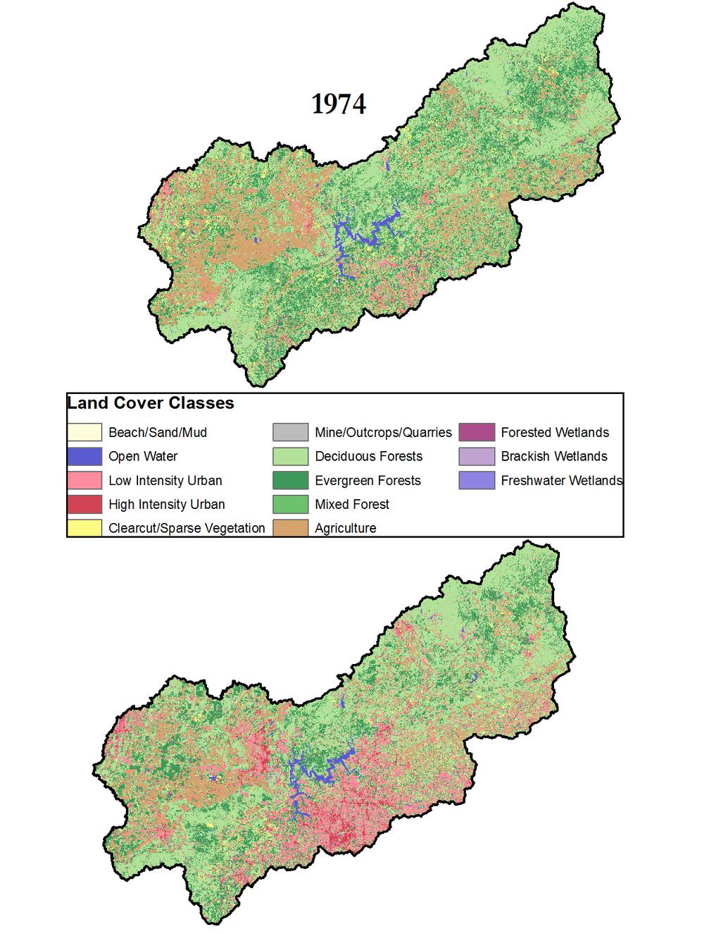
2 The watershed is experiencing rapid development that is reflected in the land cover data. The bars represent the percent of the area in each land cover category for each year. Notice the stead decrease in deciduous forest and the steady and rapid increase in low density urban land uses. Low density urban went from 45 of the area in 1974 to 28% of the area in open water Low density urban high density urban clearcut/sparse vegetation decidous forest evergreen forest mixed forest agriculture forested wetlands The map below shows the changes in land cover between 1974 and Most of the change has occurred in the lower part of the Etowah watershed and around Lake Allatoona. Much of the area that was previously agriculture has been replaced by low density urban (residential) development.
3

4 The map above illustrates the location of the forest resource priority areas found in the Etowah watershed. These areas represent areas which are still at least 30% forested. Two of the priority areas are represented in the watershed the Blue Ridge and the Ridge and Valley ecoregions. Large tracts of the priority area in the Blue Ridge is owned and managed by the US Forest Service or Georgia Department of Natural Resources.
5 Low Intensity Urban High Intensity Urban Clearcut/Sparse Vegetation 2008 (Acres) Dediduous Forest Evergreen Forest Mixed Forest Forested Wetlands NAMES Agriculture Ridge and Valley 11, ,702 76,366 38,474 2,494 19, Blue Ridge 33,369 2,179 7, ,059 75,649 5,267 21,774 1, (Acres) Ridge and Valley 2, ,595 81,430 34, ,389 1,116 Blue Ridge 7, , ,773 98,122 4,735 25,652 1,662 The table above reports the acres of each land cover categories in 2008 and 1974 found in priority areas. The forest cover in these areas showed only small losses compared with the changes in the rest of the watershed. There was a dramatic increase in urban low intensity urban area over the 34 year period. These changes reflect the areas of public land that has remained forested while privately owned forests have been experiencing a dramatic transformation to suburban and exurban housing development. The figure below depicts the priority areas for the Sustainable Community Forest Program. The areas are identified based upon population density data calculated from the US Census Bureau's census tract information. Areas with high population densities (above 1000 people/sq mi) are urban, suburban populations are people/sq mile, and Wildland Urban Interface is from people/sq mile.

6 In the period between 1991 and 2008 tree canopy cover remained fairly stable in the watershed. However there was a large increase in the percent of impervious surface throughout the watershed. Impervious surface was at 11% in 1991 and increased to 20% in 2008.
7 450, , , , , , , , , Rural Wildland Urban I Suburban Urban 400, , , , , , , , Rural Wildland Urban Interface Suburban Urban - The two charts above represent land use change in each of the Sustainable Community Priority areas. There was a slight loss of forest within all of the forest classes in all of the areas between
8 The biggest change that occurred was the increase in how density urban land use and the loss of agriculture in the area. Therefore, most of the development is taking place at the expense of agriculture in the basin with the potential for increases in forest cover over time Percent Impervious Surface Percent Canopy In 1974 almost 500,000 hectares of forest was found to be in large patches of greater than 250 acres. over the course of the next 34 years there was a considerable loss of forest patch connectivity. By 2008 on 260,000 were still in larger patches. The fragmentation resulted in a continuous increase in edge and isolated patches of forest. 600, , , , ,000 patch edge perferated core (<250 acres) core ( acres) core (>500 acres) 100,

9 Maps of forest fragmentation for the watershed are seen below. Large forest core areas are still seen in the northern part of the watershed. These lands are predominantly public lands that are either owned or managed by the US Forest Service or Georgia DNR. Much of the fragmentation has occurred in the lower part of the watershed and corresponds to urban growth which has moved up from metro Atlanta in Cobb, Cherokee and Forsyth counties. This increase in fragmentation threatens water quality, and biodiversity protection. (See the data layers available for viewing at

10 Tree canopy density maps indicate a modest loss of tree canopy cover in areas of high urban growth this includes Cobb, Cherokee, north Fulton and Forsyth Counties, all in the southern part of the watershed. In addition canopy loss occurred along the Georgia 400 corridor through Dawson county. Impervious surface density maps show increases in impervious surfaces and heavy development in the southern part of the watershed and along the GA 400 Corridor and around Cartersville in Bartow County. Much of the growth is restricted from the northern part of the watershed because it is mostly part of the Chattahoochee National Forest.

11 The interactive map server, provides users with the ability to view changes in land cover, impervious surface and canopy cover over the course of 34 years in the Etowah watershed and the entire state of Georgia. Other data available includes information on water resources such as listed impaired water bodies, locations of drinking water supply watersheds, wildfire and forest health threats, floodplains, wetlands, and high biodiversity areas. All of this information can be used for planning activities. Below is a map showing water quality information and the location of watersheds that protect drinking water supply. Forest restoration programs can help local communities better protect their drinking water supply by reducing the non point source pollution that causes much of the impairment in the Etowah watershed. These stream impairments are from urban and agricultural runoff. Reforestation programs that are supported by farm bill programs such as EQIP and other programs sponsored by the Georgia Forestry Commission can help land owners and communities better protect these resources. The information in this map can be used to help prioritize programs across the watershed.

12 In addition to drinking water concerns, the streams and rivers in the Etowah Watershed are important for trout and other rare fishes. The map below shows where watershed restoration efforts might be prioritized for the protection of both drinking water supply as well as key recreational opportunities such as trout fishing and the protection of rare species.
13 There is an opportunity to work with these data to develop watershed protection and other green space plans. Consultation with local stakeholders indicated that it is critical to begin to develop better estimates of BMP efficiencies for these forested areas or potential restoration sites, before they would want to utilize the information. Stakeholders will not invest in planning until they can see hard numbers which show both economic and environmental benefits of forest management beyond traditional forestry applications.
Minnesota Stewardship Spatial Analysis Project Methodology and Analysis documentation January 28, 2008
 Minnesota Stewardship Spatial Analysis Project Methodology and Analysis documentation January 28, 2008 Summary In the fall of 2004, Minnesota DNR and the U.S. Forest Service began working together to create
Cherokee County Future Conditions Floodplain Development
 TECHNICAL MEMORANDUM Cherokee County Future Conditions Floodplain Development Prepared for: Prepared by: Geoff Morton, P.E., County Engineer Cherokee County Richard Greuel, P.E.,, Inc. Richard Taylor,
Metro Atlanta s Water: Everything You Wanted To Know About Your Water (but were afraid to ask)
") Metro Atlanta s Water: Everything You Wanted To Know About Your Water (but were afraid to ask) June 2014 Regional Snapshot Atlanta Regional Commission For more information, contact: KZitsch@atlantaregional.com
Metro Atlanta s Water: Everything You Wanted To Know About Your Water (but were afraid to ask) June 2014 Regional Snapshot Atlanta Regional Commission For more information, contact: KZitsch@atlantaregional.com
awetlands aprairie aforests ahabitat for Fish, Game & Wildlife
 Rec. H1 priority land habitats pp. 63-67 Priority areas identified in integrated mapping assessing critical land habitat and threats to habitat pp.33-63 o Mapping is scalable for use in localized areas
North Dakota s Nutrient Reduction Strategy. Presented to the 2016 ND Water Quality Monitoring Conference March 4, 2016
 North Dakota s Nutrient Reduction Strategy Presented to the 2016 ND Water Quality Monitoring Conference March 4, 2016 Nutrients Nutrients, in appropriate amounts, are essential to the growth and health
Forest Stewardship Spatial Analysis Project Illinois Methodology March, 2007
 Forest Stewardship Spatial Analysis Project Illinois Methodology March, 2007 Project Summary Administered by the U.S. Forest Service and implemented by State forestry agencies, the Forest Stewardship Program
THINKING LIKE A WATERSHED. Using a Watershed Approach to Improve Wetland and Stream Restoration Outcomes
 THINKING LIKE A WATERSHED Using a Watershed Approach to Improve Wetland and Stream Restoration Outcomes Project Overview: The Watershed Approach to Compensatory Mitigation Site selection should follow
CUMULATIVE IMPACT ANALYSIS: A SIMPLE MODEL FOR LOCAL GOVERNMENT RESERVOIRS AND WITHDRAWALS IN GEORGIA
 CUMULATIVE IMPACT ANALYSIS: A SIMPLE MODEL FOR LOCAL GOVERNMENT RESERVOIRS AND WITHDRAWALS IN GEORGIA Nolton G. Johnson AUTHOR: Chief, Water Resources Branch, Georgia Environmental Protection Division,
FEDERAL CLEAN WATER ACT NATIONAL POLLUTANT DISCHARGE ELIMINATION SYSTEM (NPDES) PROGRAM
 PROGRAM") The Act requires that the District-wide Watershed Management Plan shall build upon and be coordinated with existing watershed planning efforts undertaken by local governments. Local governments in the
The Act requires that the District-wide Watershed Management Plan shall build upon and be coordinated with existing watershed planning efforts undertaken by local governments. Local governments in the
Goose Creek Watershed Assessment Summary October 2003
 Goose Creek Watershed Assessment Summary October 2003 The Goose Creek Watershed The Goose Creek watershed is 385 square miles, covering nearly half of Loudoun County and one-quarter of Fauquier County
Phase III Watershed Implementation Plans
 Phase III Watershed Implementation Plans Including programmatic outcomes in your planning to provide co-benefits for your community and reduce pollution Rachel Felver Chesapeake Bay Program Director of
Source Water Assessment Plan
 Prepared for Paulding County, Georgia Source Water Assessment Plan Richland Creek Reservoir Water Supply Program August 15, 2017 Prepared by Brown and Caldwell 990 Hammond Dr., Suite 400 Atlanta, GA 30328
C. Staffing Needs Approximately 150 staff days TSA #3 staff time will also be utilized.
 2017 Annual Plan I. Introduction The purpose of this annual plan is to detail work items that will be completed in 2017. The annual plan will provide a tool for SWCD staff and supervisors to evaluate program
EXECUTIVE SUMMARY DES PLAINES RIVER WATERSHED-BASED PLAN WHY A WATERSHED-BASED PLAN? WHAT IS A WATERSHED?
 Des Plaines River Watershed-Based Plan EXECUTIVE SUMMARY June 2018 EXECUTIVE SUMMARY DES PLAINES RIVER WATERSHED-BASED PLAN WHY A WATERSHED-BASED PLAN? Water is elemental to our lives. Plants and animals,
Georgia's Nonpoint Source Management Program. Linda MacGregor Watershed Protection Branch Georgia Environmental Protection Division
 Georgia's Nonpoint Source Linda MacGregor Watershed Protection Branch Georgia Environmental Protection Division Overview of Georgia s Nonpoint Source Georgia s s Nonpoint Source is a comprehensive framework
LAND & WATER CONSERVATION FUND Preserving the Best of the American Outdoors
 LAND & WATER CONSERVATION FUND Preserving the Best of the American Outdoors FY 2010 Land Acquisition Requests U.S.D.A. Forest Service, Southern Region Chattahoochee & Oconee National Forests State of Georgia
St. Joseph River Watershed 319 Project Technical Subcommittee November 3, 2003 Meeting Summary DRAFT
 St. Joseph River Watershed 319 Project Technical Subcommittee November 3, 2003 Meeting Summary DRAFT Attendees Sandra Nordmark, FOTSJR Steve Blumer, USGS Water Resources Division Todd Kesselring, Elkhart
Appendix 5A Priority Landscapes GIS Analysis Methodology
 Appendix 5A Priority Landscapes GIS Analysis Methodology Overview This appendix describes the methodology used for Pennsylvania s Priority Landscapes GIS Analysis. The figure below is a conceptual diagram
Water and Watersheds. Data Maps Action
 Water and Watersheds Data Maps Action What is the Wildlife Action Plan? Restore rare wildlife and habitats. Keep common species common. 2015 Revision: Partners in Conservation Science 2015 Revision Data
American Tree Farm System Management Plan Template
 American Tree Farm System Management Plan Template State Tree Farm # Tree Farm Property Location Tree Farm Name: Ownership 1 : County: Tax Map ID: Location 2 : State: GPS Coordinates: Tree Farmer Contact
WATERSHED RESTORATION PLAN
 WATERSHED RESTORATION PLAN FOR THE UPPER COHANSEY RIVER WATERSHED SCOPE OF WORK Background Information The proposed watershed study area for the Upper Cohansey River is 30.4 square miles. Based upon numerous
Chapter 4 Watershed Goals and Objectives
 Chapter 4 Watershed Goals and Objectives Eight (8) long-term watershed goals have been developed by the NEW Watershed Advisory Group (WAG) after consideration of discussions held during monthly watershed
The U.S. Army Corps of Engineers Regulatory Program in Georgia
 The U.S. Army Corps of Engineers Regulatory Program in Georgia David Lekson, PWS Kelly Finch, PWS Richard Morgan Savannah District August, 2013 US Army Corps of Engineers Topics Savannah District Regulatory
Chapter 5 Goals and Objectives of the Watershed
 Chapter 5 Goals and Objectives of the Watershed 5.1 Goals for the Watershed 5.2 Objectives for the Watershed Goals 5.2.1 Water Quality Impairments 5.2.2 Preserving and Protecting Designated Areas 5.2.3
COTTONWOOD CREEK RECLAMATION PHASE I & II
 COTTONWOOD CREEK RECLAMATION PHASE I & II COTTONWOOD CREEK RECLAMATION Stream Stabilization Approach to Urban Runoff Quality Cherry Creek Basin Water Quality Authority The Problem The Cherry Creek Reservoir
Photo courtesy of George Wilmot
 Mattawoman project Genesis Proposed Cross County Connector Interest in developing an Ecosystem-based management approach to watershed resource protection Opportunity to influence the County Comprehensive
Leveraging Resources for Implementing a Successful Nonpoint Source Grant Project
 Leveraging Resources for Implementing a Successful Nonpoint Source Grant Project Nathaniel Sajdak Watershed Director Sussex County Municipal Utilities Authority Wallkill River Watershed Management Group
Model Riparian Buffer Ordinance.
 Model Riparian Buffer Ordinance. This is a sample riparian buffer ordinance written as an amendment to an existing zoning ordinance. This ordinance complies with the state minimum standards for river corridor
Porter County Soil & Water Conservation District Five Year Strategic Plan
 Porter County Soil & Water Conservation District Five Year Strategic Plan 2017-2021 This long range strategic plan has been developed to guide the Porter County Soil and Water Conservation District s programs
Grand Traverse Bay Watershed Protection Plan:
 Grand Traverse Bay Watershed Protection Plan: An Overview Sarah U Ren Program Director The Watershed Center 231-935-1514, suren@gtbay.org What is a Watershed? A watershed is an area of land that captures
Outcomes. Kelly Karll-SEMCOG Margaret Barondess - MDOT
 Eco-Logical: I-75 Corridor I-75 Conservation Transportation Action Planning in to Monroe Achieve County: Multiple Stormwater Environmental Considerations Outcomes Kelly Karll-SEMCOG Karll@semcog.org Margaret
Bear Creek/Bear Lake Upper Watershed Information and Education Plan
 Bear Creek/Bear Lake Upper Watershed Information and Education Plan Addressing Stormwater Pollution Prevention and the Muskegon Lake Area of Concern Eutrophication Beneficial Use Impairment (BUI) 2010
An Overview of Vermont s Clean Water Act Julie Moore, P.E. August 14, 2017
 An Overview of Vermont s Clean Water Act Julie Moore, P.E. August 14, 2017 (with credit due to Marli Rupe) 1 What is a TMDL? (Total Maximum Daily Load) 1. The maximum amount (load) of a pollutant any surface
INDIAN CREEK WATERSHED PLAN EXECUTIVE SUMMARY
 INDIAN CREEK WATERSHED PLAN EXECUTIVE SUMMARY The Indian Creek Watershed covers a 38 square mile area in southern Lake County, Illinois that drains 24,116 acres before discharging into the Des Plaines
US Forest Service Open Space Conservation Strategy
 US Forest Service Open Space Conservation Strategy Transportation Research Board September 3, 2008 Atlanta, Georgia Photo Credit: Regents at the University of Minnesota. All rights reserved. Used with
ENVIRONMENTAL CONSIDERATIONS FOR EVALUATING INTERBASIN WATER TRANSFERS IN GEORGIA
 ENVIRONMENTAL CONSIDERATIONS FOR EVALUATING INTERBASIN WATER TRANSFERS IN GEORGIA Nolton G. Johnson, Steven R. Layman, and Cristin C. Krachon AUTHORS: Geosyntec Consultants, 1255 Roberts Blvd NW, Suite
COUNTY-BY-COUNTY WATER FACILITY CAPACITY AND EXPANSION SCHEDULE
 COUNTY-BY-COUNTY WATER FACILITY CAPACITY AND EXPANSION SCHEDULE This Appendix outlines the schedule for expanding water facility treatment capacities in the Metro Water District. Appendix B details the
The Purpose and Scope of this Guidance
 Introduction The nation s aquatic resources are among its most valuable assets. While environmental protection programs in the United States have successfully improved water quality during the past 25
Introducing Act 64 - the Vermont Clean Water Act - and Vermont s Clean Water Goals
 Introducing Act 64 - the Vermont Clean Water Act - and Vermont s Clean Water Goals Marli Rupe, DEC Clean Water Initiative Program Asst. Manager February 22, 2016 Clean Waters are a Critical Community Asset
How Much Habitat Is Enough? How Much Disturbance is Too Much?
 How Much Habitat Is Enough? How Much Disturbance is Too Much? Jocelyn Sherwood Canadian Wildlife Service - Ontario January 27 th, 2017 Page 2 April 19, 2017 Page 3 April 19, 2017 Grasslands Forest Wetlands
Setting the Course for Improved Water Quality Collecting Land Use Data for TMDLs
 Setting the Course for Improved Water Quality Collecting Land Use Data for TMDLs A TMDL training program for local government leaders and other water managers Session 6b wq-iw3-56b In this presentation
W A T E R S U P P L Y A N D W A T E R C O N S E R V AT I O N M A N A G E M E N T P L A N M A Y
 This Section identifies surface water supply sources for the Metro Water District to meet future water demands. The first part of this Section discusses the water supply sources intended to meet water
New Jersey Forest Stewardship Program Spatial Analysis Project Map Products And Data Layers Descriptions
 New Jersey Forest Stewardship Program Spatial Analysis Project 2007 Map Products And Data Layers Descriptions 01/07 NJ Forest Stewardship Program (FSP) Spatial Analysis Project (SAP) Methodology Project
Project Information. Pursuant to Section 404 of the Clean Water Act (33 U.S. Code 1344), notice is hereby given that
, notice is hereby given that") US ARMY Corps Of Engineers Little Rock District JOINT PUBLIC NOTICE CORPS OF ENGINEERS STATE OF ARKANSAS Application Number: 2013-00331 Date: November 4, 2013 Comments Due: December 4, 2013 TO WHOM IT
US ARMY Corps Of Engineers Little Rock District JOINT PUBLIC NOTICE CORPS OF ENGINEERS STATE OF ARKANSAS Application Number: 2013-00331 Date: November 4, 2013 Comments Due: December 4, 2013 TO WHOM IT
Please join us to learn the results of the project!!
 Wirth Lake Excess Nutrients TMDL Public Notice Meeting When: June 24 th, 5:30 p.m. 7:00 p.m. Where: Theodore Wirth Park, Wirth Golf Chalet, 1339 Theodore Wirth Pkwy. Minneapolis, MN 55411 Why: The Minnesota
City of Virginia Beach Urban Tree Canopy Implementation Plan. Susan French, City Arborist Barbara Duke, Senior Planner
 City of Virginia Beach Urban Tree Canopy Implementation Plan Susan French, City Arborist Barbara Duke, Senior Planner Urban Tree Canopy Implementation Plan Motivation In 2012: PAR began active development
CHAPTER 4 WATERSHED PLAN GOALS & OBJECTIVES
 4.0 Introduction CHAPTER 4 WATERSHED PLAN GOALS & OBJECTIVES After the watershed analysis had been completed, the next step in the planning process followed by the group was to come up with goals and objectives
The New Economies of the Redwood Region in the 21 st Century 1
 The New Economies of the Redwood Region in the 21 st Century 1 William Stewart 2 Abstract The redwood region of California has experienced a number of major land use changes over the past one hundred and
Jordan River Basin. Planning for the Future. Salt Lake County Watershed Symposium (August 11, 2011) Todd Stonely Utah Division of Water Resources
 Todd Stonely Utah Division of Water Resources") Jordan River Basin Planning for the Future Todd Stonely Utah Division of Water Resources Salt Lake County Watershed Symposium (August 11, 2011) 8/12/2011 Jordan River Basin Planning for the Future Slide
Jordan River Basin Planning for the Future Todd Stonely Utah Division of Water Resources Salt Lake County Watershed Symposium (August 11, 2011) 8/12/2011 Jordan River Basin Planning for the Future Slide
Environmental Check List Georgia Environmental Policy Act
 Environmental Check List Georgia Environmental Policy Act Project No. : Project Name: GEORGIA IS AREA AFFECTED? IF AFFECTED, HOW SEVERELY? AREA/CATEGORY NO YES UNKNOWN MINOR MEDIAN MAJOR UNKNOWN 1. Wetlands
DEVELOPING A WATERSHED IMPROVEMENT PLAN TO MEET MULTIPLE COMMUNITY OBJECTIVES IN GAINESVILLE AND HALL COUNTY, GEORGIA
 DEVELOPING A WATERSHED IMPROVEMENT PLAN TO MEET MULTIPLE COMMUNITY OBJECTIVES IN GAINESVILLE AND HALL COUNTY, GEORGIA Chrissy, Thom 1, David Dockery 2, Kevin McInturff 3, Betsy Massie 1, and Lauren Murphy
The Relationship of Agriculture, Water and the Environment
 The Relationship of Agriculture, Water and the Environment Marcia Fox DNREC, Division of Watershed Stewardship, Nonpoint Source Program Delaware s Watersheds Piedmont Delaware Basin Chesapeake Basin Inland
Percent Forest Cover in Connecticut
 Percent Forest Cover in Connecticut 100% 80% 60% Forest Cover in CT 40% 20% 0% 1620 1790 1840 1880 1900 1914 1953 1985 1998 USDA U.S. Forest Service and Landsat World Referencing System, Laboratory for
Results of Georgia s 2017 Silvicultural Best Management Practices Implementation and Compliance Survey
 Results of Georgia s 2017 Silvicultural Best Management Practices Implementation and Compliance Survey Prepared by the Georgia Forestry Commission in cooperation with the Environmental Protection Division
PROTECTING THE BIG HAYNES CREEK WATERSHED: A STRATEGY FOR LAND MANAGEMENT AND NONPOINT POLLUTION CONTROL
 PROTECTING THE BIG HAYNES CREEK WATERSHED: A STRATEGY FOR LAND MANAGEMENT AND NONPOINT POLLUTION CONTROL Denise L. Schmidt AUTHOR: Principal Environmental Planner, Atlanta Regional Commission, 3715 Northside
Walnut Creek Watershed Management Authority
 Walnut Creek Watershed Management Authority Respond by November, 21, 2014 Notice for Request for Qualifications The newly formed Walnut Creek Watershed Management Authority seeks qualified professionals
Chapter 10 Natural Environment
 Chapter 10 Natural Environment Existing Conditions The Natural Environment Element addresses the protection, conservation, preservation, and restoration of the natural resources the Bayview Ridge Subarea,
LOWER DRUM PLANNING UNIT Yuba-Bear River Watershed
 Existing Conditions & Uses Overview Provides open space and recreation opportunities within the Sierra Nevada foothills 1,098 acres in Placer and Nevada Counties 789 acres outside the FERC boundary; 309
TAC CHARRETTE WORKBOOK Ecosystem Management and Sustainable Forestry Practices
 For Discussion Purposes TAC CHARRETTE WORKBOOK Ecosystem Management and Sustainable Forestry Practices NEW JERSEY HIGHLANDS COUNCIL March 28, 2006 1 Overview of RMP Goals and Structure NEW JERSEY HIGHLANDS
CODORUS CREEK NONPOINT SOURCE POLLUTION CONTROL WATERSHED IMPLEMENTATION PLAN, YORK COUNTY, PENNSYLVANIA
 CODORUS CREEK NONPOINT SOURCE POLLUTION CONTROL WATERSHED IMPLEMENTATION PLAN, YORK COUNTY, PENNSYLVANIA PADEP 319 Watershed Improvement Program Prepared by: York County Conservation District Prepared
Wisconsin Wastewater Operators Association. Protecting Our Water Resources: The Future Bill Hafs - NEW Water 10/2014
 Wisconsin Wastewater Operators Association Protecting Our Water Resources: The Future Bill Hafs - NEW Water 10/2014 The Fox River Contributes 1/3 of All Nutrients to Lake Michigan APRIL 15, 2011 Photo
Mud Lake Lakeshed Assessment
 Mud Lake Lakeshed Assessment The lakeshed vitals table identifies where to focus organizational and management efforts for each lake. Criteria were developed using limnological concepts to determine the
Georgia s Aquifers. USGS Fact Sheet
 Georgia s Aquifers USGS Fact Sheet 2006-3077 1 2005 Groundwater Use by Aquifer Withdrawal (mgd) 700 600 500 400 300 200 100 0 55.4% 17.5% 7.6% 6.0% 9.2% 4.3% 60% 50% 40% 30% 20% 10% 0% Percent of Withdrawal
Existing Conditions and Environmental Consequences Water Quality
 3.6 3.6.1 HOW IS WATER QUALITY ASSESSED? The Clean Water Act (CWA) of 1972 requires that each state set water quality standards for all contaminants in surface waters. These standards are typically based
City of Valdosta Land Development Regulations
 Chapter 324 Section 324-1 Environmental Planning Criteria Protection of Groundwater Recharge Areas (A) Purpose and Intent. Pursuant to O.C.G.A. 12-2-8 and the Georgia Department of Natural Resources (DNR),
Chesapeake Bay TMDL Phase III Watershed Implementation Plan (WIP) Russ Baxter Deputy Secretary of Natural Resources
 Russ Baxter Deputy Secretary of Natural Resources") Chesapeake Bay TMDL Phase III Watershed Implementation Plan (WIP) Russ Baxter Deputy Secretary of Natural Resources russ.baxter@governor.virginia.gov 1 Topics for Today Your Role Purpose and Timing Chesapeake
Chesapeake Bay TMDL Phase III Watershed Implementation Plan (WIP) Russ Baxter Deputy Secretary of Natural Resources russ.baxter@governor.virginia.gov 1 Topics for Today Your Role Purpose and Timing Chesapeake
Surface Water Management
 Surface Water Management Figure 7: Examples of Nonpoint Source Pollution The water quality leaving the metropolitan area is as good as the water quality entering the metropolitan area, and in compliance
Beverly. Produced in This report and associated map provide information about important sites for biodiversity conservation in your area.
 CONSERVING THE BIODIVERSITY OF MASSACHUSETTS IN A CHANGING WORLD Beverly Produced in 2012 This report and associated map provide information about important sites for biodiversity conservation in your
SOURCE WATER ASSESSMENT PROJECT:
 SOURCE WATER ASSESSMENT PROJECT: An Assessment of Potential for Pollution of Surface Drinking Water Supply Sources Prepared by the Atlanta Regional Commission for Cherokee County Water & Sewer Authority
WATERSHED MANAGEMENT IN MINNESOTA. GOVERNANCE, PLANNING, AND FUNDING June 19, 2018 Cedar Rapids, Iowa
 WATERSHED MANAGEMENT IN MINNESOTA GOVERNANCE, PLANNING, AND FUNDING June 19, 2018 Cedar Rapids, Iowa GOVERNANCE - WD 1955 Watershed Act (MN Statute 103D) Local petition to form VOLUNTARY watershed district
THE MISSISSIPPI RIVER TRUST
 THE MISSISSIPPI RIVER TRUST Operates as a land trust in six states along the Lower Mississippi River. Primary tool is the conservation easement, which allows willing landowners to protect important ecological
Cannon River One Watershed, One Plan. POLICY COMMITTEE MEETING January 10, 2018 Rice County Government Center Faribault, MN
 Cannon River One, One Plan POLICY COMMITTEE MEETING January 10, 2018 Rice County Government Center Faribault, MN TASK Task 1. Aggregate Existing Physical & Spatial Data 1A. Create project maps 1B. Meeting
Capacity Building Through the Watershed Approach
 Capacity Building Through the Watershed Approach Mississippi Department of Environmental Quality (MDEQ) and US Environmental Protection Agency, Region 4 (USEPA, R4) MDEQ Process 1. Develop water quality
Support legislation that will protect the quantity of water in Lake Erie
 Specific Regional Priorities Each of Pennsylvania s major drainage basins has an array of individual characteristics that distinguish it from other regions of the state. These include diverse geographic
TOTAL: 5,250 acres over next 20 years 3
 Siting of Wetland Mitigation in Northeast Minnesota Issues, Concepts, and Alternatives from the Interagency Northeast Mitigation Siting Team 1 2 Projected Future Impacts TOTAL: 5,250 acres over next 20
Little River Watershed Restoration Project. Mark Powell, Consultant Natural Resources Management
 Little River Watershed Restoration Project Mark Powell, Consultant Natural Resources Management Lessons Learned Strong partnerships RC&D, Soil and Water, 2 counties, Albemarle Commission, Universities,
BMP 5.4.2: Protect /Conserve/Enhance Riparian Areas
 BMP 5.4.2: Protect /Conserve/Enhance Riparian Areas The Executive Council of the Chesapeake Bay Program defines a Riparian Forest Buffer as "an area of trees, usually accompanied by shrubs and other vegetation,
Conservation Planning. for Proactive Conservation. Nate Fuller Southwest Michigan Land Conservancy
 Conservation Planning for Proactive Conservation Nate Fuller Southwest Michigan Land Conservancy Conserving the scenic and ecologically important landscapes of southwest Michigan. Presettlement Vegetation
Blue Lake Stormwater Retrofit Analysis
 P a g e 1 Blue Lake Stormwater Retrofit Analysis Prepared by: Isanti Soil and Water Conservation District And Sherburne Soil and Water Conservation District P a g e 4 Executive Summary Blue Lake and its
Texas Riparian & Stream Ecosystem Training Program Update
 Texas Riparian & Stream Ecosystem Training Program Update Clare Entwistle; Nikki Dictson; Dr. Fouad Jaber; Destiny Russell; Nathan Glavy Texas Water Resources Institute Threats to Riparian Areas Riparian
Decentralized Wastewater Treatment in Texas Watersheds
 Decentralized Wastewater Treatment in Texas Watersheds Bruce Lesikar Texas A&M University System Overview Surface water resources Water Quality Standards Watershed Management Programs Identifying Sources
How Much Habitat is Enough?
 How Much Habitat is Enough? Canadian Wildlife Service 2017 Third Edition Page 2 April 19, 2017 Grasslands Forest Wetlands Riparian & Watershed Page 3 April 19, 2017 Significant impairment in stream At
Long Prairie River Watershed Restoration and Protection Strategies (WRAPS) Report Summary
 Report Summary") Long Prairie River Watershed Restoration and Protection Strategies (WRAPS) Report Summary Minnesota has adopted a watershed approach to address the state s 80 major watersheds (denoted by 8-digit hydrologic
Long Prairie River Watershed Restoration and Protection Strategies (WRAPS) Report Summary Minnesota has adopted a watershed approach to address the state s 80 major watersheds (denoted by 8-digit hydrologic
WATERSHED MANAGEMENT FOR LAKE LANIER: PERSPECTIVES ON INTER-GOVERNMENTAL IMPLEMENTATION
 WATERSHED MANAGEMENT FOR LAKE LANIER: PERSPECTIVES ON INTER-GOVERNMENTAL IMPLEMENTATION Douglas S. Baughman', Mary E. Horton 2, Tim Merritt3 and Robert R. Rivers 4 AUTHORS: Senior Environmental Scientist
Using GIS for Prioritization in Subwatershed Restoration
 Using GIS for Prioritization in Subwatershed Restoration Elena Horvath Advisor: Joseph Bishop, PhD November 10, 2011 The Pennsylvania State University Master in Geographic Information Systems www.gis.psu.edu
Conservation Ontario s Response to Climate Ready: Ontario s Adaptation Strategy and Action Plan June 2011
 Introduction Conservation Ontario s Response to Climate Ready: Ontario s Adaptation Strategy and Action Plan June 2011 C onservation Ontario is the network of 36 Conservation Authorities, local watershed
STREAM AND BUFFER AREA PROTECTION/RESTORATION
 STREAM AND BUFFER AREA PROTECTION/RESTORATION AMENDMENT OPTIONS TO STRENGTHEN POLICY IN HEADWATERS AREAS DRAFT SUBSEQUENT TO THE JANUARY 25, 2007 MEETING OF THE PLANNING COMMISSION ENVIRONMENT COMMITTEE
June 15, 2010 Public Meeting. Byron Petrauskas Blue Ridge Environmental Solutions, Inc.
 June 15, 2010 Public Meeting Byron Petrauskas Blue Ridge Environmental Solutions, Inc. Virginia Department of Environmental Quality has identified that poor water quality exists in: Little Dark Run and
Town of Sumner 2025 Comprehensive Plan
 2016 Update to: Planning Report 2025 Comprehensive Plan Jefferson County, Wisconsin October 2002 1 Page 1-4 Census Count Table 1-1 Population Trends 1970 2000; updated with 2010 Data # Change 1970 1980
Surface Water. Solutions for a better world
 1 Surface Water Solutions for a better world Our Surface Water Services Expertise Growing worldwide awareness of water scarcity has encouraged water preservation programs, better irrigation techniques
SKIBO PROJECT SCOPING REPORT Laurentian Ranger District, Superior National Forest
 SKIBO PROJECT SCOPING REPORT Laurentian Ranger District, Superior National Forest I. Introduction The Laurentian Ranger District of the Superior National Forest is proposing management activities within
Hello my name is Joy Loughry and I am with the groundwater technical unit of the Minnesota department of natural resources. Today I am going to talk
 Hello my name is Joy Loughry and I am with the groundwater technical unit of the Minnesota department of natural resources. Today I am going to talk about how the state of Minnesota manages its Water resources
Fact Sheet. Pennsylvania s Chesapeake Bay Tributary Strategy Goals for Nutrient and Sediment Reduction and Habitat Restoration
 Fact Sheet Commonwealth of Pennsylvania Department of Environmental Protection Pennsylvania s Chesapeake Bay Tributary Strategy Goals for Nutrient and Sediment Reduction and Habitat Restoration Why were
Walton Family Foundation Freshwater Initiative Strategy
 Walton Family Foundation Freshwater Initiative Strategy This document summarizes the five year strategy for the Walton Family Foundation s Freshwater Initiative. This strategy was adopted by the Foundation
The US Department of Agriculture s (USDA s) Regional
 Regional") Feature Article In an effort to promote the Environmental Quality Incentives Program as part of the West Fork White River Watershed Initiative, landowners receive one-on-one property visits. Photo courtesy
Feature Article In an effort to promote the Environmental Quality Incentives Program as part of the West Fork White River Watershed Initiative, landowners receive one-on-one property visits. Photo courtesy
PROJECT SUMMARY WHAT:
 PROJECT SUMMARY WHAT: A conservation partnership to identify flood-prone cleared land in the Lower Mississippi River s active floodplain that landowners desire to reforest through Wetland Reserve Easements.
HARPETH RIVER/JONES CREEK WATERSHED-BASED PLAN
 HARPETH RIVER/JONES CREEK WATERSHED-BASED PLAN Harpeth River Watershed Association PO Box 1127 Franklin, TN 37065 March 2007 Table of Contents Page 1. Identification of Causes and Sources 1 1.1. Unnamed
GEORGIA DEPARTMENT OF TRANSPORTATION NPDES MS4 COMPLIANCE
 This Section focuses on state and regional policy recommendations to further implementation of watershed management and water resources protection in the Metro Water District. These recommendations are
Natural Resources of Chatham
 Natural Resources of Chatham Andrew Meyer, Beth Roessler, Karen Strong, and Emily Vail NYSDEC Hudson River Estuary Program and Cornell University Presentation to Town of Chatham, December 6, 2012 The Hudson
A Report on the City of Lexington s Existing and Possible Urban Tree Canopy
 A Report on the City of Lexington s Existing and Possible Urban Tree Canopy Project Background Key Terms The analysis of Lexington s urban tree canopy (UTC) was carried out at the request of the Virginia