I-5/Mellen Street to Blakeslee Junction (Horseshoe Lake) Mitigation Site USACE IP NWS
|
|
|
- Ralph Fisher
- 5 years ago
- Views:
Transcription

1 I-5/Mellen Street to Blakeslee Junction (Horseshoe Lake) Mitigation Site USACE IP NWS Southwest Region 2018 MONITORING REPORT Wetlands Program Issued March 2019 Environmental Services Office
2 Author: Trace McKellips Editor: Kristen Andrews For additional information about this report or the WSDOT Wetlands Program, please contact: Kristen Andrews, Wetlands Program WSDOT, Environmental Services Office P. O. Box 47332, Olympia, WA Phone: Monitoring reports are published on the web at:

3 I-5/Mellen Street to Blakeslee Junction (Horseshoe Lake) Mitigation Site USACE IP NWS USACE IP Number Mitigation Location General Site Information NWS LLID Number Construction Date Monitoring Period Year of Monitoring 3 of 10 South of the City of Centralia and 0.5 miles west of I-5 in Lewis County Type of Impact Wetland Buffer Oak Woodland Area of Project Impact 1 Type of Mitigation Planned Area of Mitigation acres 2.32 acres Buffer establishment Oak Woodland Establishment 25 acres 12 acres 1 Impact numbers sourced from WSDOT Mitigation numbers sourced from WSDOT 2011.
4 This Page Intentionally Left Blank
5 Summary of Monitoring Results and Management Activities (2018) Performance Standards 2018 Results 3 Management Activities Minimum density of 4,000 plants/acre and at least 6 species of trees and/or shrubs present Blackberry Species and Class B (WA Dept. of Agriculture and Lewis County Weed Board) noxious weeds will not exceed 15% Class A Noxious Weeds (WA Dept. of Agriculture and Lewis County), Japanese knotweed, and purple loosestrife shall be treated 4,967 plants/acre (CI 80% = ) with 20 species present Planted 7,400 native woody plants in January % cover (qualitative) Spot sprayed for blackberry species, tansy ragwort, and non-native thistle species None observed (May-Jun 2018) Report Introduction This report summarizes third-year (Year 3) monitoring activities at the 005 Horseshoe Lake Mitigation Site. Included are a site description, the performance standards, an explanation of monitoring methods, and an evaluation of site development. Monitoring activities included vegetation surveys and photo-documentation on July 16 and 17, Estimated values are presented with their corresponding statistical confidence interval. For example, 4,967 plants/acre (CI 80% = ) means we are 80% confident that the true density is between 4452 and 5482 plants/acre. 005 Horseshoe Lake Annual Monitoring Report

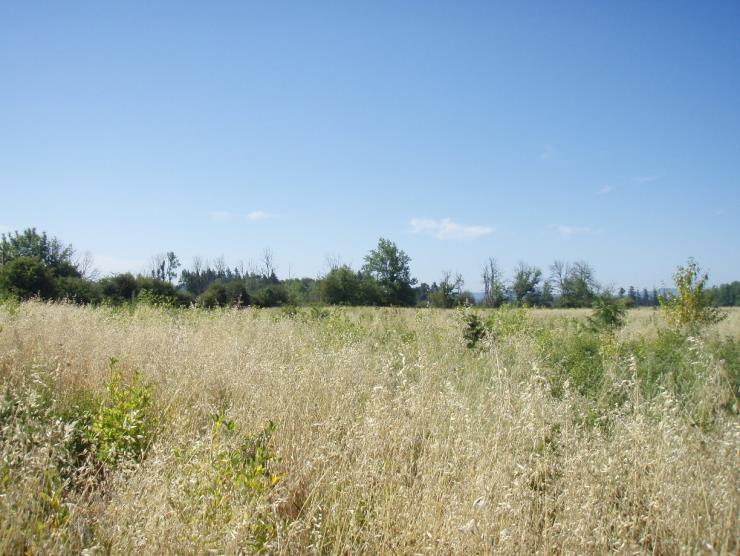
6 What is the 005 Horseshoe Lake Mitigation Site? This acre mitigation site (Figure 1) is a site located directly south of the City of Centralia and west of Interstate 5. This site was created to compensate for the permanent loss of acres of wetland buffer and 2.32 acres of oak woodland due to road improvements along Interstate 5. Twenty-five acres of the site were used for wetland buffer mitigation and 12 acres were used for Oregon white oak woodland mitigation with the remaining acreage to be used to mitigate for future projects. This site is intended to reestablish important buffer functions in a largely fragmented floodplain and enhance valuable wildlife habitat. Figure 1 Site Sketch The 005 Horseshoe Lake mitigation site is located just 1300 feet north of the Chehalis River with a tributary to the river flowing through the site, north to south. Horseshoe Lake is on the eastern boundary of the site and there is a depression in the southeastern corner of the site that impounds water during the winter months. Appendix 2 includes site directions. 005 Horseshoe Lake Annual Monitoring Report
7 What are the performance standards for this site? Year 3 Performance Standard 1 At monitoring Year 3, there will be a minimum density of 4,000 living native woody species per acre and at least six species of native trees and/or shrubs will be present in the native woody species areas (Scrub-shrub, wetland buffer, and riparian enhancement areas). Performance Standard 2 The aerial extent of blackberry species and Class B (WA Dept of Agriculture and Lewis County Weed Board) noxious weeds will not exceed 15 percent in the combined scrub-shrub, buffer, and riparian planting areas, exclusive to each mitigation site. Performance Standard 3 If/when detected, Class A noxious weeds (WA Dept. of Agriculture and Lewis County), Japanese knotweed, and purple loosestrife shall be treated so that the species do not exist on the sites. These species shall not be included in the 15 percent cover allowed for invasive species. Appendix 1 shows the planting plan (WSDOT 2014). 005 Horseshoe Lake Annual Monitoring Report
.")
8 How were the performance standards evaluated? The tables below document the sample methods used for performance standards (PS) as required by the mitigation plan or permits. For additional details on the methods see the WSDOT Wetland Mitigation Site Monitoring Methods Paper (WSDOT 2008). Placement of Baseline: The 752 meter baseline was placed lengthwise across the site at a 20 bearing. Using ESRI software, a random number generator determined the first transect point. An interval of 40 meters separated each remaining transect. Attribute PS 1 PS 2 PS 3 Density Cover Presence/Absence Target Native woody Noxious/ population species invasive Noxious weeds Zone Entire site Entire Site Entire Site Sample method UBT Qualitative Qualitative SU length N/A N/A N/A SU width 1 N/A N/A Points per SU N/A N/A N/A Total # of SU 19 N/A N/A Figure 2 Site Sampling Design (2018) 005 Horseshoe Lake Annual Monitoring Report
9 How is the site developing? Overall the site is developing well. The site meets its third-year native woody density standard. Native woody species are established throughout the site and have an average height of 1-2 meters. The upland oak woodland zone is dominated by snowberry (Symphoricarpos albus). Other prominent upland species are western serviceberry (Amelanchier alnifolia), Oregon ash (Fraxinus latifolia), and Indian plum (Oemleria cerasiformis). Oregon white oaks (Quercus garryana) have also established in the upland. This species provides a unique vegetation community and associated wildlife habitat. Some plants however have not adapted to the hot and dry summer conditions. Over 63,000 native woody species suited to dry summers will be planted in January Plantings in the wetland along the southern and western site edges are dominated by redosier dogwood (Cornus alba) and Oregon ash (Fraxinus latifolia). These established species appear to be preventing the intrusion of reed canarygrass (Phalaris arundinacea) that surround the site perimeter. Isolated thickets of non-native blackberry and patches of tansy ragwort (Jacobaea vulgaris) are found throughout the upland zone. The site s agricultural history and human disturbances have resulted in a host of Class C weeds and other non-native species to establish on site. Most native species are able to coexist alongside these introduced plants. 005 Horseshoe Lake Annual Monitoring Report
10 Results for Performance Standard 1 (Minimum density of 4,000 living woody species per acre and at least six species of native trees and/or shrubs): Density is estimated at 4967 plants/acre (CI80% = ). Snowberry (Symphoricarpos albus) was the dominant species. Other species that were abundant on site included western serviceberry (Amelanchier alnifolia), redosier dogwood (Cornus alba), Oregon ash (Fraxinus latifolia), and Indian plum (Oemleria cerasiformis) (Photo 1). A total of 20 species of trees and shrubs were included in the sample. Results for Performance Standard 2 (Blackberry Species and Class B noxious weeds will not exceed 15 percent): Photo 1 Native plants in Upland Buffer (July 2018) Non-native blackberry species are estimated at 3 percent cover across the site. Tansy ragwort (Jacobaea vulgaris) was also observed throughout the planting areas (Photo 2). Results for Performance Standard 3 (Class A Noxious Weeds (WA Dept. of Agriculture and Lewis County), Japanese knotweed, and purple loosestrife shall be treated): No Class A noxious weeds observed. Photo 2 Tansy Ragwort & Class C weeds (July 2018) 005 Horseshoe Lake Annual Monitoring Report
11 What is planned for this site? WSDOT will continue to control Class B noxious weed species. Over 63,000 bare root plants will be planted in the winter of in northern sections of the site with lower overall cover that had been previously dominated by Queen Ann s Lace. These plants include western serviceberry, redosier dogwood, oceanspray, Indian plum, snowberry, Lewis' mock orange (Philadelphus lewisii), hardhack (Spiraea douglasii), and twinberry honeysuckle (Lonicera involucrata). 005 Horseshoe Lake Annual Monitoring Report

12 Appendix 1 Planting Plan (from WSDOT 2014) 005 Horseshoe Lake Annual Monitoring Report


13 Appendix 2 Photo Points The photographs below were taken from permanent photo-points on July 18, 2018 and document current site development. Photo Point 1A Photo Point 1B Photo Point 1C Photo Point 1D 005 Horseshoe Lake Annual Monitoring Report


14 Photo Point 2A Photo Point 2B Photo Point 3 Photo Point 4A 005 Horseshoe Lake Annual Monitoring Report


15 Photo Point 4B Photo Point 4C Driving Directions: From I-5 take Exit 81. Take ramp right for WA 507, north toward Mellen Street. Turn right onto WA 507/Mellen Street and go forward until bearing left onto Military Road. In a half a mile, turn left onto South Scheuber Road. The gravel driveway to the site will be directly on the east side of the street. Park here and walk into the planted area of the site. 005 Horseshoe Lake Annual Monitoring Report
16 Literature Cited 1. [USACE] US Army Corps of Engineers Department of the Army Individual Permit Number NWS [WDFW] Washington State Department of Fish and Wildlife Hydraulic Project Approval Control Number [WSDOT] Washington State Department of Transportation Final Critical Areas Mitigation Report, I-5/Mellen Street to Blakeslee Junction Add Lanes, Interchange Improvement Project. Lewis County (WA): Washington State Department of Transportation, Southwest Region. 4. [WSDOT] Washington State Department of Transportation I-5 Mellen Street to Blakeslee Junction Stage 2, Horseshoe Lake Planting Plan. 5. [WSDOT] Washington State Department of Transportation WSDOT Wetland Mitigation Site Monitoring Methods Horseshoe Lake Annual Monitoring Report
I-405 Congestion Relief and Bus Rapid Transit Projects: Renton Nickel Improvement Project (Renton Stage 1) Mitigation Site USACE NWP
 Mitigation Site USACE NWP") I-405 Congestion Relief and Bus Rapid Transit Projects: Renton Nickel Improvement Project (Renton Stage 1) Mitigation Site USACE NWP 2006-00097 Northwest Region 2016 MONITORING REPORT Wetlands Program
I-405 Congestion Relief and Bus Rapid Transit Projects: Renton Nickel Improvement Project (Renton Stage 1) Mitigation Site USACE NWP 2006-00097 Northwest Region 2016 MONITORING REPORT Wetlands Program
SR 520 Medina to SR 202 Eastside Transit and HOV (Yarrow Creek Wetland) Mitigation Site USACE IP NWS
 Mitigation Site USACE IP NWS") SR 520 Medina to SR 202 Eastside Transit and HOV (Yarrow Creek Wetland) Mitigation Site USACE IP NWS-2009-562 Northwest Region 2018 MONITORING REPORT Wetlands Program Issued March 2019 Environmental Services
SR 520 Medina to SR 202 Eastside Transit and HOV (Yarrow Creek Wetland) Mitigation Site USACE IP NWS-2009-562 Northwest Region 2018 MONITORING REPORT Wetlands Program Issued March 2019 Environmental Services
I-90 Snoqualmie Pass East Project (Rocky Run Creek) Mitigation Site USACE IP NWS
 Mitigation Site USACE IP NWS") I-90 Snoqualmie Pass East Project (Rocky Run Creek) Mitigation Site USACE IP NWS-2007-2080 South Central Region 2016 MONITORING REPORT Wetlands Program Issued March 2017 Environmental Services Office Author:
I-90 Snoqualmie Pass East Project (Rocky Run Creek) Mitigation Site USACE IP NWS-2007-2080 South Central Region 2016 MONITORING REPORT Wetlands Program Issued March 2017 Environmental Services Office Author:
SR nd Street SE to 112th Street SE (527 Widening) Mitigation Site WIN # A52720B USACE NWP (14)
 Mitigation Site WIN # A52720B USACE NWP (14)") SR 527 132nd Street SE to 112th Street SE (527 Widening) Mitigation Site WIN # A52720B USACE NWP (14) 2002-00046 Northwest Region 2016 MONITORING REPORT Wetlands Program Issued March 2017 Environmental
SR 527 132nd Street SE to 112th Street SE (527 Widening) Mitigation Site WIN # A52720B USACE NWP (14) 2002-00046 Northwest Region 2016 MONITORING REPORT Wetlands Program Issued March 2017 Environmental
Heron Glen Wetland Buffer Enhancement Project. Progress Report. November 15, 2005
 Heron Glen Wetland Buffer Enhancement Project Progress Report November 15, 2005 Summary of Activity Since Last Report (August 2004) Weed Control There were few Scots broom (Cytisus scoparius) plants that
SR 161: Jovita Boulevard to South 360th St. Stage 2 / WSDOT Stream Buffer Mitigation (Agreement Y-9403) 2012 Final Monitoring Report
 2012 Final Monitoring Report") 2012 SR 161: Jovita Boulevard to South 360th St. Stage 2 / WSDOT Stream Buffer Mitigation (Agreement Y-9403) 2012 Final Monitoring Report SR 161: Jovita Boulevard to South 360th St. Stage 2 (MP 31.95 to
2012 SR 161: Jovita Boulevard to South 360th St. Stage 2 / WSDOT Stream Buffer Mitigation (Agreement Y-9403) 2012 Final Monitoring Report SR 161: Jovita Boulevard to South 360th St. Stage 2 (MP 31.95 to
Wetland and Stream Sensitive Areas Study for Buffer Reduction Parcels and -0178, Lake Forest Park, WA
 March 10, 2017 Darin Seader 2301 NE Perkins Way Lake Forest Park, WA 98155 AOA-4800 SUBJECT: Wetland and Stream Sensitive Areas Study for Buffer Reduction Parcels 866590-0181 and -0178, Lake Forest Park,
Wetland and Stream Sensitive Areas Study Boundary Line Adjustment/Reasonable Use Parcels and -0178, Lake Forest Park, WA
 March 10, 2017 Darin Seader 2301 NE Perkins Way Lake Forest Park, WA 98155 AOA-4800 SUBJECT: Wetland and Stream Sensitive Areas Study Boundary Line Adjustment/Reasonable Use Parcels 866590-0181 and -0178,
Writing Performance Standards for Wetland Mitigation
 Writing Performance Standards for Wetland Mitigation WSDOT Updated 08/23/17 Performance standards are critical components of any wetland mitigation report. These performance criteria describe measurable
Cromwell Park Wetland Mitigation Year 3 Summer Monitoring
 Cromwell Park Wetland Mitigation Year 3 Summer Monitoring October, 2013 Prepared for: Brian Landau Surface Water and Environmental Services Program Manager City of Shoreline Public Works Department 17500
ANNUAL REPORT SHILLAPOO WILDLIFE AREA BPA Project #:
 ANNUAL REPORT SHILLAPOO WILDLIFE AREA BPA Project #: 2003-012-00 Prepared for: Joe Deherrera Bonneville Power Administration Prepared by: Brian Calkins Wildlife Area Manager Washington Department of Fish
Appendix D Wetland and Stream Photographs
 Appendix D Wetland and Stream Photographs WETLAND PHOTOS Wetland 5-1: north end of wetland in I-5 right-of-way (ROW), looking south. Himalayan blackberry is overgrowing wetland; scattered willows and
Habitat Restoration of Garoutte Prairie: 2016 Annual Report
 Habitat Restoration of Garoutte Prairie: 2016 Annual Report 3/31/2017 Report prepared for the Bureau of Land Management, Agreement #L13AC00098 Report prepared by Anna Ramthun and Andy Neill Institute for
5.4 Alternative 2: Structural Flood Protection Without Flood Retention Facility
 5.4 Alternative 2: Structural Flood Protection Without Flood Retention Facility Structural Flood Protection Without Flood Retention Facility (Alternative 2) would reduce flood damage during a major flood
Jessica Shaw Agricultural Technician Washington State University Whatcom County Extension Suite 201 Bellingham, WA
 Agricultural Waterway Buffer Study Whatcom County, Washington 202 Authors: Chris Benedict Regional Extension Specialist Washington State University Whatcom County Extension Suite 20 Bellingham, WA 98225
CCSD#1 Stormwater Standards
 SECTION 4 NATURAL RESOURCES AND VEGETATED BUFFERS The provisions of this section are intended to prevent and reduce adverse impacts and to enhance drainageways and natural resources. These requirements
RESTORATION EVALUATION PLAN
 RESTORATION EVALUATION PLAN Project Name: Ramsey Refugia Project Project Proponent: Columbia Slough Watershed Council Project Goal (the overall intent of the habitat restoration effort; in some cases,
PRE-PROPOSAL FORM Lewis River Aquatic Fund 2011
 PRE-PROPOSAL FORM Lewis River Aquatic Fund 2011 Form Intent: To provide a venue for an applicant to clearly indicate the technical basis and support for proposed project. Specifically the project s consistency
Stewardship Plan instructions REN Capstone 2010
 Stewardship Plan instructions REN Capstone 2010 due May 14 th, 2010 as a Word document to TA & CD to client The stewardship plan (SP) is the project site owner s manual for clients and their designated
Title 92 ROADSIDE VEGETATION MANAGEMENT POLICY
 Title 92 Chapters: ROADSIDE VEGETATION MANAGEMENT POLICY Chapter 92.04 - ROADSIDE VEGETATION MANAGEMENT Chapter 92.04 Sections: ROADSIDE VEGETATION MANAGEMENT 92.04.010 ROADSIDE MAINTENANCE. 92.04.020
270 Pullman to Idaho State Line (Sunshine Road) Mitigation Site USACE IP
 Mitigation Site USACE IP") 270 Pullman to Idaho State Line (Sunshine Road) Mitigation Site USACE IP 200500225 Eastern Region 2018 MONITORING REPORT Wetlands Program Issued March 2019 Environmental Services Office Author: Trace McKellips
270 Pullman to Idaho State Line (Sunshine Road) Mitigation Site USACE IP 200500225 Eastern Region 2018 MONITORING REPORT Wetlands Program Issued March 2019 Environmental Services Office Author: Trace McKellips
Shannon Claeson USDA Forest Service, PNW Research Station, Olympia, WA Olympic Knotweed Working Group Nov 16, 2011
 Shannon Claeson USDA Forest Service, PNW Research Station, Olympia, WA sclaeson@fs.fed.us Olympic Working Group Nov 16, 2011 Perennial Dense monocultures Moist soil, partial sunlight Disturbed sites (rivers,
BASELINE DOCUMENTATION REPORT
 BASELINE DOCUMENTATION REPORT FOR LAKE FOREST ESTATES MACEDONIA, OHIO SUMMIT COUNTY, OHIO September 15, 2006 January 5, 2007 Prepared for: Lake Forest Estates Homeowner s Association, Inc. c/o TransCon
SECTION 10: WETLANDS PROTECTION
 SECTION 10: WETLANDS PROTECTION 10-1 INTENT AND PURPOSE A. Intent 1. The City finds that wetlands serve a variety of beneficial functions. Wetlands maintain water quality, reduce flooding and erosion,
Naomi Hansen. Todd: Rothwell, Rebecca (ECY) Monday, October 02, :12 PM Todd Boulanger La Center Riverside Estates wetlands
 Monday, October 02, :12 PM Todd Boulanger La Center Riverside Estates wetlands") Naomi Hansen From: Sent: To: Subject: Rothwell, Rebecca (ECY) Monday, October 2, 27 4:2 PM Todd Boulanger La Center Riverside Estates wetlands Todd: I have briefly reviewed the Castle
Naomi Hansen From: Sent: To: Subject: Rothwell, Rebecca (ECY) Monday, October 2, 27 4:2 PM Todd Boulanger La Center Riverside Estates wetlands Todd: I have briefly reviewed the Castle
PORT OF VANCOUVER, USA PARCEL 1A NE LAYDOWN CRITICAL AREAS REPORT
 PORT OF VANCOUVER, USA PARCEL 1A NE LAYDOWN CRITICAL AREAS REPORT February 2012 Prepared by: Port of Vancouver, USA 3103 NW Lower River Road Vancouver, Washington 98660 360.693.3611 CONTENTS 1 Introduction...
Overland Park, KS Stream Riparian Corridor Quality Evaluation
 Overland Park, KS Stream Riparian Corridor Quality Evaluation Attachment A Page 1 of 4 General The Overland Park Stream Riparian Corridor Quality Rating (QR) is a standardized assessment of the quality
2016 Vegetation Monitoring at Herbert Farm & Natural Area: Phase I Restoration Web version
 2016 Vegetation Monitoring at Herbert Farm & Natural Area: Phase I Restoration Web version 3/29/2017 Summary report to the City of Corvallis and Oregon Department of Fish and Wildlife Report prepared by
Department of the Army Permit Application
 Department of the Army Permit Application DA File Number U.S. Army Corps of Engineers Honolulu District Date Received by CEPOH-RO Send Completed Application to: Honolulu District, U.S. Army Corps of Engineers
Meacham Creek Restoration Project
 Meacham Creek Restoration Project Meacham Creek Restoration Project Umatilla National Forest Walla Walla Ranger District Michael Rassbach, District Ranger Public Scoping Document Proposal Summary The Walla
Vegetation Cover Type Mapping Study Plan for Energy Northwest's Packwood Lake Hydroelectric Project FERC No Lewis County, Washington
 Revised Vegetation Cover Type Mapping Study Plan for Energy Northwest's Packwood Lake Hydroelectric Project FERC No. 2244 Lewis County, Washington Submitted to P.O. Box 968 Richland, Washington 99352-0968
STAFF REPORT CHELAN COUNTY PUD DAROGA DOMESTIC WATER SYSTEM
 STAFF REPORT CHELAN COUNTY PUD DAROGA DOMESTIC WATER SYSTEM TO: Douglas County Hearing Examiner FROM: Douglas County Land Services Staff RE: Chelan County PUD, SCUP-12-01 DATE: July 5, 2012 I. GENERAL
Hitchcock s blue-eyed grass (Sisyrinchium hitchcockii) Habitat Restoration at Lost Creek Meadow: 2016 Annual Report
 Habitat Restoration at Lost Creek Meadow: 2016 Annual Report") Hitchcock s blue-eyed grass (Sisyrinchium hitchcockii) Habitat Restoration at Lost Creek Meadow: 2016 Annual Report 3/31/2017 2016 Annual Report. Submitted to the Bureau of Land Management, Agreement #L13AC00098-29,
Hitchcock s blue-eyed grass (Sisyrinchium hitchcockii) Habitat Restoration at Lost Creek Meadow: 2016 Annual Report 3/31/2017 2016 Annual Report. Submitted to the Bureau of Land Management, Agreement #L13AC00098-29,
CATEGORY a protection of the natural environment, its ecosystems and biodiversity.
 29. ENVIRONMENTAL DEVELOPMENT PERMIT AREA CATEGORY a protection of the natural environment, its ecosystems and biodiversity. The requirement to obtain an environmental development permit is cited in Section
Soils Study. Swan Lake Hydroelectric Project (FERC Project No. 2911) June Long View Associates, Inc. Ridgefield, Washington
 June Long View Associates, Inc. Ridgefield, Washington") Swan Lake Hydroelectric Project (FERC Project No. 2911) June 2012 Ketchikan, Alaska Prepared by: Long View Associates, Inc. Ridgefield, Washington and Tetra Tech Bothell, Washington [This page intentionally
Swan Lake Hydroelectric Project (FERC Project No. 2911) June 2012 Ketchikan, Alaska Prepared by: Long View Associates, Inc. Ridgefield, Washington and Tetra Tech Bothell, Washington [This page intentionally
Willamette Special Investment Partnership PRE-APPLICATION Funds Requested $199, Total Project Cost $ $250,000.00
 Willamette Special Investment Partnership I. GENERAL INFORMATION PRE-APPLICATION -2013 Funds Requested $199,590.00 Total Project Cost $ $250,000.00 Round to nearest dollar Round to nearest dollar Name
INVASIVE SPECIES CONTROL PLAN FOR CONSTRUCTION ACTIVITIES AND POST CONSTRUCTION MONITORING
 INVASIVE SPECIES CONTROL PLAN FOR CONSTRUCTION ACTIVITIES AND POST CONSTRUCTION MONITORING INTRODUCTION Black Oak Wind Farm, LLC is proposing to develop a wind-powered electric generating facility (the
Joint Public Notice. Proposed Wetland Mitigation Bank. Linnton Mill Restoration Site Mitigation Bank, Multnomah County, Oregon
 US Army Corps of Engineers Portland District Oregon Department of State Lands Joint Public Notice Proposed Wetland Mitigation Bank Linnton Mill Restoration Site Mitigation Bank, Multnomah County, Oregon
PERFORMANCE STANDARDS AND MONITORING PROTOCOL FOR TIDAL WETLAND MITIGATION BANKS. October 28, 2016
 PERFORMANCE STANDARDS AND MONITORING PROTOCOL FOR TIDAL WETLAND MITIGATION BANKS October 28, 2016 A. Tidal wetland mitigation banks shall conform to the following performance standards by the end of the
New Jersey Forest Stewardship Program Spatial Analysis Project Map Products And Data Layers Descriptions
 New Jersey Forest Stewardship Program Spatial Analysis Project 2007 Map Products And Data Layers Descriptions 01/07 NJ Forest Stewardship Program (FSP) Spatial Analysis Project (SAP) Methodology Project
King County Monitoring Memo, February 2018
 Grass control outperforms watering for increasing the growth and survival in black cottonwood (Populus balsamifera L. spp. trichocarpa) stakes in pasture grasses on the Cedar River, WA (2017 Results) King
Public Notice ISSUED: March 18, 2016 EXPIRES: April 18, 2016
 APPLICANT: REFER TO: Mattamy Homes 2005-04142-PRH Public Notice ISSUED: March 18, 2016 EXPIRES: April 18, 2016 SECTION: 404 - Clean Water Act 1. APPLICATION FOR PERMIT to discharge dredged and fill material
U.S. Army Corps of Engineers, Alaska District PRECONSTRUCTION NOTIFICATION FORM
 U.S. Army Corps of Engineers, Alaska District PRECONSTRUCTION NOTIFICATION FORM May be used instead of Form ENG 4345 to request verification under a Nationwide Permit (NWP) Applicant: Address: City, State,
Pullman Airport Expansion Permitting Process Overview, Wetlands and Mitigation. October 25, 2017
 Pullman Airport Expansion Permitting Process Overview, Wetlands and Mitigation October 25, 2017 Overview of the Airport Project The Pullman Airport Expansion Project includes: Realignment of Runway 6/24
Peer review of submittal documents for the Fairhaven Highlands Project as they relate to Plants and Animals
 5309 Shilshole Avenue NW Suite 200 Seattle, WA 98107 206.789.9658 phone 206.789.9684 fax www.adolfson.com memorandum date to from cc subject Vikki Jackson, Northwest Ecological Services, LLC Lara Thoreson
Appendix Q Conceptual Mitigation Plan for Impacts to Wetlands and Other Waters of the United States
 for Impacts to Wetlands and Other Waters of the United States Q.1 Introduction This Conceptual Mitigation Plan (Plan) is intended to provide a framework for identifying the potential mitigation areas and
October 3, PUBLIC NOTICE Savannah District
 DEPARTMENT OF THE ARMY U.S. CORPS OF ENGINEERS SAVANNAH DISTRICT 1590 ADAMSON PARKWAY, SUITE 200 MORROW, GEORGIA 30260-1777 October 3, 2018 Regulatory Branch SAS-2016-00808 PUBLIC NOTICE Savannah District
Project Information. Pursuant to Section 404 of the Clean Water Act (33 U.S. Code 1344), notice is hereby given that
, notice is hereby given that") US ARMY Corps Of Engineers Little Rock District JOINT PUBLIC NOTICE CORPS OF ENGINEERS STATE OF ARKANSAS Application Number: 2014-00083-1 Date: December 22, 2014 Comments Due: January 16, 2015 TO WHOM
US ARMY Corps Of Engineers Little Rock District JOINT PUBLIC NOTICE CORPS OF ENGINEERS STATE OF ARKANSAS Application Number: 2014-00083-1 Date: December 22, 2014 Comments Due: January 16, 2015 TO WHOM
5.15 Wetlands and Other Waters of the U.S.
 I-70 East Final EIS 5.15 Wetlands and Other Waters of the U.S. 5.15 Wetlands and Other Waters of the U.S. This section discusses wetlands, open waters, and other waters of the U.S. in the study area and
Camden and Rockland Water Company
 Camden and Rockland Water Company File No.: 199201515 City and State: West Rockport, ME General Impacts: 1.13 acres of an unspecified type Functions and Values Lost: (From Compensation Plan) Groundwater
Lake Campbell and Lake Erie 2015 Aquatic Plant Control Program
 Lake Campbell and Lake Erie 2015 Aquatic Plant Control Program Prepared for: Lake Erie & Campbell LMD #3 Skagit County Public Works Mount Vernon, Washington Prepared by: Northwest Aquatic Eco-Systems 855
Critical Areas Study Ludwig Road Preliminary PRD 820 Ludwig Road, Snohomish, WA Parcels , , &
 September 17, 2018 Skip Coddington GSC Development, Inc. PO Box 1623 Woodinville, WA 98072 AOA-5405 SUBJECT: Critical Areas Study Ludwig Road Preliminary PRD 820 Ludwig Road, Snohomish, WA Parcels 280512-003-018-00,
Sensitive Species Monitoring and Habitat Restoration of Lost Creek Meadow
 Sensitive Species Monitoring and Habitat Restoration of Lost Creek Meadow 2/15/2016 2015 Annual Report Report prepared by Andy Neill Institute for Applied Ecology PREFACE This report is the result of agreement
NEW YORK STATE DEPARTMENT OF ENVIRONMENTAL CONSERVATION
 NEW YORK STATE DEPARTMENT OF ENVIRONMENTAL CONSERVATION October 17, 2011 Mr. Chris Hogan New York State Department of Environmental Conservation Division of Environmental Permits, 4 th Floor 625 Broadway
TREASURE COAST REGIONAL PLANNING COUNCIL M E M O R A N D U M. To: Council Members AGENDA ITEM 5E
 TREASURE COAST REGIONAL PLANNING COUNCIL M E M O R A N D U M To: Council Members AGENDA ITEM 5E From: Date: Subject: Staff March 15, 2013 Council Meeting Intergovernmental Coordination and Review Log The
Wood Canyon Emergent Wetland Project. City of Aliso Viejo 12 Journey, Suite 100 Aliso Viejo, CA 92656
 Wood Canyon Emergent Wetland Project City of Aliso Viejo 12 Journey, Suite 100 Aliso Viejo, CA 92656 Introduction Wood Canyon is located within Aliso and Wood Canyon Regional Park in southwest Orange County,
APPENDIX A Application Form for Regional General Permit 7 (RGP-7) Valid: July 26, 2011-July 26, 2016
 Valid: July 26, 2011-July 26, 2016") RGP 7 Page 1 of 6 APPENDIX A Application Form for Regional General Permit 7 (RGP-7) Valid: July 26, 2011-July 26, 2016 Please fully complete a JARPA and this form and submit with vicinity, plan, and elevation
RGP 7 Page 1 of 6 APPENDIX A Application Form for Regional General Permit 7 (RGP-7) Valid: July 26, 2011-July 26, 2016 Please fully complete a JARPA and this form and submit with vicinity, plan, and elevation
Society of Wetland Scientists/ Association of State Wetland Managers Joint Regional Conference, Portland, OR, September 18, 2008
 Reestablishing a Riverine Wetland Using Integrated Pest Management to Control Reed Canarygrass and Reference Wetlands Design Criteria to Restore Structure, Functions, and Habitat-Forming Processes Society
2017 Agricultural Water Quality Workshop
 2017 Agricultural Water Quality Workshop Focus Area Lower Lewis and Clark Clatsop SWCD has identified this area as one that needs much improvement This does not mean we can t do projects in other areas
Rogue River Mile 128 Riparian Restoration Annual Monitoring Report
 Rogue River Mile 128 Riparian Restoration Annual Monitoring Report November 2012 December 2013 (Project Year 01) Date Submitted: March 31, 2014 PROJECT INFORMATION Project Name Rogue River Mile 128 ECP
Review of Natural Environment Existing Conditions, Johnston Road Study Area
 Brunton Consulting Services 216 Lincoln Heights Road, Ottawa, Ontario K2B 8A8 Phone: (613) 829-7307 Fax: (613) 829-4688 e-mail: bruntonconsulting@rogers.com January 13, 2011 Review of Natural Environment
WETLAND DELINEATION REPORT
 WETLAND DELINEATION REPORT WHITMORE LAKE LOT WASHTENAW COUNTY, MICHIGAN JULY 2015 PREPARED FOR: WASHTENAW COUNTY PARKS AND RECREATION 2230 SOUTH PLATT ROAD ANN ARBOR, MICHIGAN 48104 PREPARED BY: THE MANNIK
Chapter 13: Wildlife and Vegetation
 Chapter 13: Wildlife and Vegetation Introduction and Setting Nevada County contains an extremely wide range of plants, animals and habitat types. With topographic elevations ranging from 300 feet in the
Public Notice ISSUED: May 21, 2013 EXPIRES: June 20, 2013
 SPONSOR: REFER TO: Wisconsin Dept. of Transportation Public Notice ISSUED: May 21, 2013 EXPIRES: June 20, 2013 SECTION:404 - Clean Water Act 1. WETLAND COMPENSATORY MITIGATION BANK PROPOSAL 2. SPECIFIC
Implementation of Act 162 of 2014 Riparian Buffer or Riparian Forest Buffer Offsetting
 Implementation of Act 162 of 2014 Riparian Buffer or Riparian Forest Buffer Offsetting March 11, 2015 Dial-in number for Audio: 1-877-668-4493 Access code: 642 373 389 WebEx Technical Support: 866-229-3239
POLICY FOR NATURAL RESOURCE MANAGEMENT AREAS
 POLICY FOR NATURAL RESOURCE MANAGEMENT AREAS I. POLICY STATEMENT Auburn University's (the University's) "Policy for Natural Resource Management Areas" implements the Campus Master Plan Land Use Element
Higher percentages of impervious surfaces around a waterbody increase the amount of water flowing into the waterbody from the shores, elevating the
 Want to pave your driveway? In order to get a permit to do so, you will need to look at the amount of impervious surface you already have. Under the state rules and the county ordinance, you can have 15%
RI DEM Blackstone River Bikeway
 File No.: 199300976 RI DEM Blackstone River Bikeway City and State: Pawtucket to North Smithfield, RI General Impacts: 1.77 acres PEM, PSS, PFO (0.23 permanent, 1.54 temporary) Functions and Values Lost:
APPENDIX B. If the GRANIT Data Mapper gets stuck during an operation, use the refresh button in your browser.
 APPENDIX B ANSWERING QUESTIONS THAT REQUIRE THE GRANIT DATA MAPPER ONLINE TOOLS AND PRINTED MAPS (Remaining questions are answered during field checking) Each of the questions in the table on the following
Public Notice ISSUED: 11 February 2019 EXPIRES: 13 March 2019
 SPONSOR: Minnesota Board of Water and Soil Resources Public Notice ISSUED: 11 February 2019 EXPIRES: 13 March 2019 REFER TO: MVP-2019-0122-JTB SECTION: 404 - Clean Water Act 1. WETLAND COMPENSATORY MITIGATION
Public Notice ISSUED: 20-JAN-2016 EXPIRES: 19-FEB-2016
 APPLICANT: Shakopee Mdewakanton Sioux Community Public Notice ISSUED: 20-JAN-2016 EXPIRES: 19-FEB-2016 REFER TO: MVP-2015-04726-RMM SECTION: 404 - Clean Water Act 1. APPLICATION FOR PERMIT TO discharge
APPENDIX E AVOIDANCE AND MINIMIZATION PROTOCOL FOR VERNAL POOLS
 APPENDIX E AVOIDANCE AND MINIMIZATION PROTOCOL FOR VERNAL POOLS August 2013 Avoidance and Minimization Protocol August 2013 For s Note: This page intentionally left blank Avoidance and Minimization Protocol
Long-term Management Plan For The Mitigation Bank
 Note: The California multi-agency Project Delivery Team developed this general outline to assist in the development of the Long-term Management Plan for mitigation banks. Objectives and tasks are provided
Appendix E : Guidelines for Riparian Buffer Areas
 Appendix E : Guidelines for Riparian Buffer Areas This document should be read in conjunction with the CRCA Planning Policy. 1.0 PURPOSE The purpose of this document is to summarize the recommendations
Long-term Management Plan For The Mitigation Bank
 Note: The California multi-agency Project Delivery Team developed this general outline to assist in the development of the Long-term Management Plan for mitigation banks. Objectives and tasks are provided
Boardman River Dams Committee (BRDC) Detailed Analysis of Alternatives
 Detailed Analysis of Alternatives") Boardman River Dams Committee (BRDC) Detailed Analysis of Alternatives Presentation Outline Summary of Detailed Analysis Summary of Cost and Economic Impacts Public Opinion Survey Questions and Discussion
Boardman River Dams Committee (BRDC) Detailed Analysis of Alternatives Presentation Outline Summary of Detailed Analysis Summary of Cost and Economic Impacts Public Opinion Survey Questions and Discussion
RECORD OF PLAN CONFORMANCE AND CATEGORICAL EXCLUSION (CX) DETERMINATION
 DETERMINATION") RECORD OF PLAN CONFORMANCE AND CATEGORICAL EXCLUSION (CX) DETERMINATION CX Log #: OR-014-CX-04-24 Lease or Serial #: N/A Project Name: Surveyor Salvage CX Location: T.38S., R.5E., Sections 25,26,35,36;
RECORD OF PLAN CONFORMANCE AND CATEGORICAL EXCLUSION (CX) DETERMINATION CX Log #: OR-014-CX-04-24 Lease or Serial #: N/A Project Name: Surveyor Salvage CX Location: T.38S., R.5E., Sections 25,26,35,36;
DRAFT FINDING OF NO SIGNIFICANT IMPACT. for. Tioga Sports Park
 DRAFT FINDING OF NO SIGNIFICANT IMPACT for Tioga Sports Park The U.S. Fish and Wildlife Service (USFWS) prepared an Environmental Assessment (EA) to analyze the potential effects of the proposal by the
Snitz Creek Park Wetland Mitigation Bank Prospectus. Pennsylvania Department of Transportation Engineering District 8-0
 Snitz Creek Park Wetland Mitigation Bank Prospectus Pennsylvania Department of Transportation Engineering District 8-0 February 2010 In accordance with 33 CFR 332.8(d)(2), The Pennsylvania Department of
February 6, 2018 MEMORANDUM. Council Members. SUBJECT: Update on Albeni Falls Settlement Agreement BACKGROUND:
 James Yost Chair Idaho W. Bill Booth Idaho Guy Norman Washington Tom Karier Washington Jennifer Anders Vice Chair Montana Tim Baker Montana Ted Ferrioli Oregon Richard Devlin Oregon February 6, 2018 MEMORANDUM
Information for File # MVP SJW
 Information for File # MVP-2018-02581-SJW Applicant: Robert Kiszka Fairview Cranberry Co., LLC Corps Contact: Sam Woboril Address: 2926 Post Road, Suite B, Stevens Point, Wisconsin 54481 E-Mail: samuel.j.woboril@usace.army.mil
POPULATION INTRODUCTION OF THE THIN-LEAVED PEAVINE: 2015 ANNUAL REPORT
 POPULATION INTRODUCTION OF THE THIN-LEAVED PEAVINE: 2015 ANNUAL REPORT 2016 Report to the Bureau of Land Management Agreements # L13AC00098-25 and L13AC00098-0033 Report prepared by Ian Silvernail Institute
Federal Way Link Extension
 vember 216 Federal Way Link Extension Final Environmental Impact Statement ECOSYSTEMS TECHNICAL REPORT Appendix G2 Central Puget Sound Regional Transit Authority Federal Way Link Extension Ecosystems
Chapter 10 Natural Environment
 Chapter 10 Natural Environment Existing Conditions The Natural Environment Element addresses the protection, conservation, preservation, and restoration of the natural resources the Bayview Ridge Subarea,
Site Description. Supplies (* = optional)
") Site Description Overview Regardless of the activities conducted at a site, the first visit to the monitoring plot, the site description must be completed, including identifying the plot boundaries, describing
Site Description Overview Regardless of the activities conducted at a site, the first visit to the monitoring plot, the site description must be completed, including identifying the plot boundaries, describing
Invasive Plants Taking Root in Alaska
 Invasive Plants Taking Root in Alaska Prepared by: Caleb Slemmons Homer Soil and Water Conservation District http://www.homerswcd.org November, 2006 Sponsored by: Alaska Association of Conservation Districts
Public Notice. Public Notice No. Date: April 8, 2016 CENAP-PL-E Comment Period Closes: May 9, 2016
 Public Notice Public Notice No. Date: April 8, 2016 CENAP-PL-E-16-02 Comment Period Closes: May 9, 2016 USACE Philadelphia District: http://www.nap.usace.army.mil COBBS CREEK FISH PASSAGE PROJECT SECTION
2015 Monitoring Report Year 2 Harmon Property Stream Restoration Aurora, Ohio. Corps Permit Number Prepared by:
 2015 Monitoring Report Year 2 Harmon Property Stream Restoration Aurora, Ohio Prepared by: EnviroScience Excellence n Any Environment EnviroScience, nc. 5070 Stow Rd Stow OH 44224 (330) 688-0111 Year Ending:
Riparian Vegetation Protections. Heritage Tree Protection
 PLACER Protections in place: Oak Tree Retention/ Replacement Requirements General Plan Language Specific Voluntary Rural Design require preservation of native trees and groves through replacement and dedication
NOXIOUS WEED REGULATORY GUIDELINES. Noxious Weeds in Aquatic Critical Areas: Regulatory Issues. What are Aquatic Critical Areas?
 NOXIOUS WEED REGULATORY GUIDELINES Noxious Weeds in Aquatic Critical Areas: Regulatory Issues State Weed Law RCW 17.10 requires all landowners to eradicate Class A noxious weeds and to control and prevent
Public Notice. MVK Ms. Tarmiko Graham (601) July 25, 2018 August 23, 2018
 July 25, 2018 August 23, 2018") US Army Corps of Engineers. Vicksburg District 4155 Clay Street Vicksburg, MS 39183-3435 www.mvk.usace.army.mil Public Notice APPLICATION NO.: EVALUATOR: PHONE NO.: E-MAIL: DATE: EXPIRATION DATE: MVK-2018-336
US Army Corps of Engineers. Vicksburg District 4155 Clay Street Vicksburg, MS 39183-3435 www.mvk.usace.army.mil Public Notice APPLICATION NO.: EVALUATOR: PHONE NO.: E-MAIL: DATE: EXPIRATION DATE: MVK-2018-336
Division of Surface Water Environmental Mitigation & Special Permitting Section
 GUIDANCE FOR SECTION 401 WATER QUALITY CERTIFICATION AND ISOLATED WETLAND PERMITS THROUGH THE COORDINATED APPLICATION PROCESS FOR SURFACE COAL MINE SITES Division of Surface Water Environmental Mitigation
Minnesota EAW Supplement
 Appendix I: Minnesota EAW Supplement Lower Pool 2 Channel Management Study: Boulanger Bend to Lock and Dam No. 2 Minnesota EAW Item Identification A supplement prepared for the Minnesota DNR to identify
Getting the Bad Plants Out and. Sarah Low, Strategic Nature, LLC and
 Getting the Bad Plants Out and the Good Plants Growing Sarah Low, Strategic Nature, LLC and Jim MacKenzie, Octoraro Native Plant Nursery HOW DO WE HAVE A SUCCESSFUL REFORESTATION PROJECT? First Things
FLOODPLAIN PERMIT APPLICATION SUBMITTAL REQUIREMENTS
 Planning Department 215 South 4 th Street, Suite F Hamilton, MT 59840 Phone 406-375-6530 Fax 406-375-6531 planning@rc.mt.gov FLOODPLAIN PERMIT APPLICATION SUBMITTAL REQUIREMENTS To initiate the permit
Proposed Wildlife Habitat Restoration Project At Walking Iron Wildlife Area August 6, 2015
 Proposed Wildlife Habitat Restoration Project At Walking Iron Wildlife Area August 6, 2015 Walking Iron County Wildlife Area is 898 acres situated in the Town of Mazomanie between Walking Iron County Park
DEPARTMENT OF THE ARMY U.S. ARMY CORPS OF ENGINEERS - MOBILE DISTRICT BIRMINGHAM FIELD OFFICE 218 SUMMIT PARKWAY, SUITE 222 HOMEWOOD, AL 35209
 DEPARTMENT OF THE ARMY U.S. ARMY CORPS OF ENGINEERS - MOBILE DISTRICT BIRMINGHAM FIELD OFFICE 218 SUMMIT PARKWAY, SUITE 222 HOMEWOOD, AL 35209 CESAM-RD-I-N December 7, 2012 PUBLIC NOTICE NO. SAM-2012-01506-LCB
Riparian Corridors and Required Setbacks
 Riparian Corridors and Required Setbacks This document is intended to explain where development and structures are allowed to be constructed adjacent to riparian corridors. Any proposed development (such
PROGRAMMATIC ESA 1 CONSULTATION Specific Project Information Form For Minor Bank Stabilization Repair Activities Version: May 2012
 PROGRAMMATIC ESA 1 CONSULTATION Specific Project Information Form For Minor Bank Stabilization Repair Activities Version: May 2012 Eligibility for Programmatic Consultation To be filled out by Corps This
Meeting the Challenge: Invasive Plants in Pacific Northwest Ecosystems
 September 2006 Meeting the Challenge: Invasive Plants in Pacific Northwest Ecosystems Ann Bartuska Deputy Chief, FS R&D USDA Forest Service Washington, DC Organization of Presentation The Threat Forest