Coastal Maritime Forests in Virginia Delineation and Distribution. Final report submitted to
|
|
|
- Darleen Hopkins
- 6 years ago
- Views:
Transcription


1 Coastal Maritime Forests in Virginia Delineation and Distribution Final report submitted to Virginia Coastal Zone Management Program Virginia Department of Environmental Quality Prepared by Marcia Berman and Harry Berquist Center for Coastal Resources Management Virginia Institute of Marine Science College of William and Mary Gloucester Point, Virginia This project was funded in part by the Virginia Coastal Zone Management Program at the Department of Environmental Quality through Grant # NA05NOS of the U.S. Department of Commerce, National Oceanic and Atmospheric Administration, under the Coastal Zone Management Act of 1972, as amended. The views expressed herein are those of the authors and do not necessarily reflect the views of the U.S. Department of Commerce, NOAA, or any of its subagencies. November, 2007
2 Introduction and Definitions Coastal maritime forests are important coastal habitats that receive little attention despite their declining presence along the coast. What constitutes a coastal maritime forest can vary depending on how broadly one wants to define the community structure. This study defines coastal maritime forests in part by the ecological community classification developed by the Virginia Department of Conservation and Recreation (VADCR). However, the definition used here includes only maritime dune woodlands and maritime uplands. Arguably, one could also consider forested swamps as a maritime habitat. This study makes an important distinction, consistent with the definition used by the Massachusetts Division of Fisheries and Wildlife (2006), that maritime forests or coastal forests do not tolerate standing salt water. They are, however, adaptive to salt spray on their leaves. This is a major variation from the wetter forested wetlands not considered in this study. In Virginia, maritime dune and maritime upland forests are significantly rarer habitats than their marsh counterparts, with a restricted distribution that is largely explained by habitat loss. Maritime dune woodlands are composed of deciduous, coniferous, and broadleaf evergreens. Maritime upland forests contain species-poor evergreen and mixed coastal forests (Fleming et al., 2006). They are often pinedominated, with an under story of deciduous trees. While species may grow in a broader class of soil types, the maritime dune woodlands and upland forests grow in well to rapidly drained nutrient poor sandy soils. Project Objectives This project had two major goals. The first builds on an earlier effort by the Virginia Department of Forestry, who delineated maritime forests using remote sensing techniques. Their project integrated land use and soils data to generate a map that defines potential boundaries of maritime forest. This study follows an identical approach with two major exceptions. The first is the soils data used in this study is mapped at a much finer scale. The second is this study has a field validation component that reviewed random sites around selected locations to ground-truth the remote sensing output. The Virginia Department of Forestry provided staff support from various regional offices to perform all field work. Ancillary data such as soils and aerial imagery were also used where wetland and dune habitat could be distinguished. The second major goal of this project was to compute, on a county-by-county basis, the amount of maritime forest cover present in each coastal locality, and the extent of maritime forests located within conservation lands. Boundaries for conserved lands data from VA DCR were used. The results of the study are documented here. A website hosted by the Center for Coastal Resources Management (CCRM) includes report, maps, and GIS data (
3 Acknowledgements Field support was provided entirely by the Virginia Department of Forestry. Individuals from regional offices in Gloucester, Tappahannock, Suffolk, Virginia Beach, and the Eastern Shore of Virginia played a pivotal role in reviewing and defining boundaries. Special thanks to Jack Kauffman, Toni Sanderson, Nelson Jarvis, Robbie Lewis, Rob Farrell and Dave Milby for their efforts. Additional thanks to Mike Foreman, now with the VA Department of Conservation and Recreation, for coordinating the initial collaboration. From the data side of things, John Scrivani provided digital data files for comparison. Special thanks to Joe Webber and others of the Virginia Department of Conservation and Recreation, Division of Natural Heritage for their review and comments on this project. The agency s field data was particularly helpful in validating areas where field access was not possible. This mapping project was funded in part, by the Virginia Coastal Zone Management Program at the Department of Environmental Quality through Grant #NA05NOS of the U.S. Department of Commerce, National Oceanic and Atmospheric Administration, under the Coastal Zone Management Act of 1972, as amended. The views expressed herein are those of the authors and do not necessarily reflect the views of the U.S. Department of Commerce, NOAA, or any of its subagencies. Methods Land use and land cover data were derived from a 2000 Landsat 7 thematic image classification generated by the Regional Earth Science Application Center (RESAC) at the University of Maryland. RESAC uses a modified Anderson Level II classification (Anderson et al., 1976), and a decision tree algorithm developed by their program and described in Varlyguin et al. (2001). Figure 1 illustrates the classification. A baseline forest coverage was generated by extracting deciduous forests, evergreen forests, and mix (deciduous-evergreen) forest communities from the RESAC dataset. All other classes were masked out of the analysis. Esri s ArcMap software was used. Digital soils data were derived from the National Soil Survey Geographic (SSURGO) database. These data are surveyed and mapped nationwide at scales ranging from 1:12,000 to 1:63,360. They represent the most accurate region-wide soils data available (Soil Survey Staff, no reference date). From this dataset, soils with properties typical of maritime forest habitat were extracted for coastal Virginia. Using guidance from the VADCR all non-hydric well drained, excessively drained, sandy or sandy loam soil types were extracted for the coastal plain of Virginia. This constitutes many different named soil classes. The soil classes derived in the final delineation are listed in Appendix 1. 2
 Using ArcMap a baseline delineation of maritime forest was generated by combining the land cover and the soils data.")
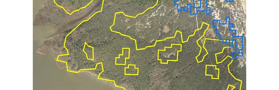
4 Figure 1. Modified Anderson Level II Land Use classification developed by RESAC (from Using ArcMap a baseline delineation of maritime forest was generated by combining the land cover and the soils data. This delineation indicated maritime forest habitat in seven different jurisdictions: Accomack, Hampton, Mathews, Norfolk, Northampton, Poquoson, and Virginia Beach. As expected, these two basic properties of maritime forests can be shared with other vegetative communities. Therefore, ancillary data combined with the expertise of local foresters, and landscape ecologists was used to refine the boundaries. Imagery and field maps were scrutinized in committee and logical exclusions were made based on topographic elevation, inundation potential, location of dunes, location of ridge and swale topography, proximity to wetlands, and proximity to the coast. By our accepted project definition, maritime forests do not grow in wet, swampy environments. Therefore vegetation that appeared to be in low lying marshes and had direct connectivity to streams was excluded. Similarly, maritime forests are coastal landscapes and despite the fact that one could detect appropriate vegetation and soils properties inland, these areas were excluded. Figure 2 is an example from Mathews County where polygons meet vegetation and soil properties but do not meet other logical habitat parameters, such as landscape position relative to the coast. Imagery proved to be an important resource for 3
5 defining ridge and swale topography and dune environments; landscape properties conducive with our maritime forest definition. A revised set of baseline field maps were generated and superimposed on 2002 high resolution natural color imagery (VBMP, 2002). For each general area, a GPS location was generated at random and plotted on field images. Foresters were given the coordinates, maps and a checklist of things to review. The checklist was provided as guidance only, and was not always returned completed (Appendix 2). Foresters conducted general ground surveys at random locations in and around the plotted site. Site locations, while random, were reviewed prior to field work to insure there was a representative sample within each delineated boundary; inclusive of edges. Appendix 3 shows the final sites reviewed in the field. Due to access problems no field reviews were conducted on the privately owned barrier islands off the eastern shore of Virginia. Following the field assessments, a revised delineation was generated for each county or city evaluated by digitizing and editing boundaries according to field recommendations while using maritime forest soils and 2002 VBMP high resolution imagery (2 ft resolution) for guidance. ArcMap was used and shape files were generated. A separate review by the VADCR Division of Natural Heritage indicated an absence of coverage on the eastern shore barrier islands. These were added to the final map compositions using comparable image processing techniques, but no field validation. Referenced survey data provided by Natural Heritage Program provided a comfortable level of ground-truthing. All map compositions are presented in Appendix 4, 5, and 6. 4

6 Figure 2. Polygons in blue highlight areas that have correct soils and forest cover, but are logically not maritime habitat based on landscape position. 5
7 General Community Risk Analysis Two factors contribute to the future potential loss of maritime forests. The first is climate change and the potential for increased storm severity that could accelerate coastal erosion. Sea level rise associated with climate change impacts also poses a risk if the natural dune environment that supports maritime forests cannot be sustained. Sustainability of dune forests in particular is largely controlled by development pressure that restricts the availability and transport of aeolian sands that maintain coastal dunes. To determine the immediate risk of development on maritime forests, GIS data delineating conserved areas (from the VA Dept. Conservation and Recreation) were superimposed on the final maritime forest habitat maps. This analysis would quantify the remaining habitat currently in conservation areas. The results are reported in Table 1. Table 1. Maritime Forest within Conservation Lands County Acres within Acres out of Conservation Conservation Total (acres) Accomack Northampton Virginia Beach Results In the final iteration, maritime forest habitat was present in only three jurisdictions: Accomack County, Northampton County and the City of Virginia Beach. The general locations are shown in Figure 3. A total of 4,093 acres was computed. The largest community exists in the City of Virginia Beach with 2,704 acres (1,094 hectares) (Appendix 4). Northampton County has 534 acres (216 hectares) (Appendix 5). Accomack County has 855 acres (346 hectares) (Appendix 6). This study revealed significantly less maritime forest habitat than an earlier estimate conducted by the Department of Forestry (DOF). We attribute major discrepancies to the coarser resolution soils (STATSGO) data used in the DOF delineation and to a lesser degree, the 6
8 absence of ground-truthing in that study. A comparison of results is illustrated in Figure 3. The VA Dept. of Conservation and Recreation s Division of Natural Heritage also provided locational information for sites where they have surveyed for maritime forest habitat. These sites are shown on the delineation maps in Appendix 4-6. Only six of the sixteen field sites they surveyed did not fall within boundaries delineated using remote sensing techniques. These generally fell out of the delineation due to soil properties and could represent a slightly different acceptance of parameters that define maritime forest. Using the conservation lands dataset compiled by VADCR we determined all but 163 acres of maritime forest habitat resides within existing conservation lands. These areas are located in Northampton County and Accomack County. According to the conservation lands boundary data provided by VADCR, maritime forest community is present north of Kiptopeke State Park and largely outside of any publicly owned property. This area may be currently undergoing development or development pressure may be evident in the vicinity of this community, but this has not been verified. Communities found on Great Neck and Savage Neck in Northampton County are also outside of protected lands. In Accomack County, only 35 of the total 855 acres are outside of publicly owned conservation lands. These areas are located in low lying uplands of the back barrier system. Given that the majority of the remaining maritime forest in Virginia in located in protected lands, one could conclude that the short-term risk to the remaining forest habitat is low. However, long-term risks associated with development pressure along the perimeter of conservation lands may impede the community from performing habitat functions in the future. An analysis of development pressure in the adjacent lands as well as an existing functional assessment of the individual communities would be required to make this determination. Also, the long-term effects associated with sea level rise and storm climate cannot be overlooked. Recommendations While short-term preservation of most remaining maritime forest habitat is sustainable by existing conservation boundaries, at least two of these sites are located outside major centers of urban and residential development. At this time, there is no assessment that determines if and how existing development impacts the ability of these habitats to perform ecosystem services. Furthermore, as development in the surrounding community of Virginia Beach and Northampton County continues, future declines in habitat function could occur. If at all possible, efforts to secure the lands in Northampton County would be recommended since the county has zoned significant undeveloped tracks for future development. A closer look at the risk associated with development along the bayside maritime forest communities would be prudent. 7
9 Further study would be needed to 1) assess the current ecosystem services existing maritime forest provide, and 2) assess the potential that future development would have on available ecosystem services. Both of these initiatives would require protocols for the evaluation of services and stressors in this environment. We would recommend a focus on habitat and flood control services to start and a review of the existing work conducted by the VADCR-NH program which could provide a base line functional assessment. Elements of different landscape models could be employed to determine potential for disruption of these services due to development. Models like the Chesapeake Bay Resource Lands Assessment may be consulted to determine ecological vulnerability resulting from development ( Based on the findings, a prediction of long-term probability for habitat sustainability may be determined. References Anderson, J.R., E.E. Hardy, J.T. Roach, and R.E. Witmer, A land use and land cover classification system for use with remote sensor data. US Geol. Surv. Prof. Pap., 964p. Commonwealth of Massachusetts Division of Fisheries and Wildlife, 2006, Natural Community Fact Sheet Coastal Forests, Maritime Forests, and Maritime Shrublands, Natural Heritage and Endangered Species Program, Westborough, MA, pp. 4. Fleming, G.P., P.P. Coulling, K.D. Patterson, and K. Taverna The natural communities of Virginia: classification of ecological community groups. Second approximation. Version 2.2. Virginia Department of Conservation and Recreation, Division of Natural Heritage, Richmond, VA. Soil Survey Staff, Natural Resources Conservation Service, United States Department of Agriculture. Soil Survey Geographic (SSURGO) Database for Survey Area, State [Online WWW] Varlyguin, D., R K Wright, S J Goetz, S D Prince (2001). Advances in land cover classification from applications research: a case study from the mid-atlantic RESAC. Available at and on ASPRS CD-ROM in American Society for Photogrammetry and Remote Sensing (ASPRS) Conference Proceedings, Washington DC. Virginia Department of Conservation and Recreation, 2005, Va Conservation Lands Database. 8
10 Figure 3. Location of maritime forests in Virginia. Delineation compares two data sources for maritime forest habitat. The revised dataset (VIMS) used higher resolution soils data. 9
11 APPENDIX 1. Soil Classes: City of Virginia Beach, Northampton County, and Accomack County Virginia Beach SSURGO Soils Classes used in the Maritime Forest Delineation ** 10 Corolla fine sand, Moderately well drained, Partially hydric (10 percent) 16E Fripp sand-2 to 30 percent slopes, Excessively drained, Partially hydric (5 percent) 18 Lakehurst variant sand, Moderately well drained, Partially hydric (5 percent) 22E Newhan fine sand-2 to 30 percent slopes, Excessively drained, Partially hydric (13 percent) 23C Newhan-Corolla fine sands-0 to 15 percent slopes, Excessively drained, Partially hydric (5 percent) Northampton AsE Assateague sand-2 to 50 percent slopes, Excessively drained, Partially hydric (5 percent) AtD Assateague fine sand-2 to 35 percent slopes-rarely flooded, Excessively drained, Partially hydric (12 percent) FhB Fisherman fine sand-0 to 6 percent slopes-occasionally flooded, Moderately well drained, Partially hydric (15 percent) FmD Fisherman-Assateague complex-0 to 35 percent slopes-rarely flooded, Moderately well drained, Partially hydric (15 percent) Accomack County AtD Assateague fine sand- 2 to 35 percent slopes- rarely flooded, Excessively drained, Partially hydric (4 percent) FhB Fisherman fine sand- 0 to 6 percent slopes- occasionally flooded, Moderately well drained, Partially hydric (2 percent) FmD Fisherman-Assateague complex- 0 to 35 percent slopes- rarely flooded, Moderately well drained, Partially hydric (5 percent) ** Similar soil classes were found in localities which did not meet other criteria for maritime forest habitat. 10
12 APPENDIX 2. General Site Review Checklist for Maritime Forest Delineation Site name (or number) Is there standing water at the site? Is there wetlands vegetation at the site? Is this site characteristic of an abandoned agricultural field? Are the boundaries of the site within view of an open water body? Is the site located in or near a beach environment? General soil description: General on site topography (e.g. high cliff, dune ridge, swale, tidal flat) Are you in agreement with the delineation by DOF for this site?* Are you in agreement with the delineation by VIMS for this site?* Does the site meet the minimum criteria for maritime forest based on the Natural Heritage Program Definition (vegetation and soils)? Do you think the site is a maritime forest? * if DOF or VIMS does not delineate the area as a maritime forest and you agree say yes. 11
13 APPENDIX 3. Field Site Review Locations* Mathews County Northampton County City of Virginia Beach * These localities in addition to the City of Poquoson and Accomack County were reviewed using remote sensing techniques as well. 12


14 13


15 14
16 15


17 16


18 17


19 18


20 19

21 20


22 21

23 22
24 APPENDIX 4. City of Virginia Beach Site 1. First Landing State Park Site 2. Back Bay Wildlife Refuge Site 3. Little Creek 23
25 24
26 25
27 26
28 27
29 28
30 29
31 30
32 APPENDIX 5. Northampton County Site 1. Fisherman s Island Site 2. Kiptopeke State Park Site 3. Savage Neck Great Neck 31
33 32
34 33
35 34
36 35
37 36
38 37
39 38
40 APPENDIX 6. Accomack County Site 1. Parramore Island Site 2. Chincoteague Island 39
41 40
42 41
43 42
44 43
45 44
Coastal Resource Management Planning
 College of William and Mary W&M Publish Reports Spring 2011 Coastal Resource Management Planning Center for Coastal Resources Management, Virginia Institute of Marine Science Follow this and additional
Chapter 10 Natural Environment
 Chapter 10 Natural Environment Existing Conditions The Natural Environment Element addresses the protection, conservation, preservation, and restoration of the natural resources the Bayview Ridge Subarea,
Kevin L. Erwin CE PWS Kevin L. Erwin Consulting Ecologist, Inc Bayside Parkway Ft. Myers, Florida USA
 Kevin L. Erwin CE PWS Kevin L. Erwin Consulting Ecologist, Inc. 2077 Bayside Parkway Ft. Myers, Florida 33901 USA The Lee County DR/GR: Implications for future restoration and management Estero Bay Watershed
Using LIDAR to monitor beach changes: Goochs Beach, Kennebunk, Maine
 Maine Geologic Facts and Localities February, 2010 Using LIDAR to monitor beach changes: Goochs Beach, Kennebunk, Maine 43 o 20 51.31 N, 70 o 28 54.18 W Text by Peter Slovinsky, Department of Agriculture,
Chapter 13: Wildlife and Vegetation
 Chapter 13: Wildlife and Vegetation Introduction and Setting Nevada County contains an extremely wide range of plants, animals and habitat types. With topographic elevations ranging from 300 feet in the
Adapting to Rising Sea Level: A Florida Perspective
 Adapting to Rising Sea Level: A Florida Perspective Randall W. Parkinson RW Parkinson Consulting, Inc., 2018 Melbourne Ct., Suite 205, Melbourne, Florida 32901, USA Abstract. Global climate change and
Climate Change, Human Activities, and the State of New Jersey. Michael J. Kennish Institute of Marine and Coastal Sciences Rutgers University
 Climate Change, Human Activities, and the State of New Jersey Michael J. Kennish Institute of Marine and Coastal Sciences Rutgers University New Jersey Climate and Environmental Change Conclusions from
Virginia s Comprehensive Wetland Program Plan
 Summer 2011, Vol. 6, No. 2 In this issue: Virginia s Comprehensive Wetland Program Plan Virginia has a newly approved Wetland Program Plan (WPP). Virginia developed a wetland plan to assess current management
A Report on Existing and Possible Tree Canopy in the City of Charlotte and Mecklenburg County, NC
 A Report on Existing and Possible Tree Canopy in the City of Charlotte and Mecklenburg County, NC Why is Tree Canopy Important? Tree canopy (TC) is the layer of leaves, branches, and stems of trees that
Title: City of Santa Barbara Sea Level Rise Vulnerability Assessment
 Bren 2014-2015 Group Project Proposal: Title: City of Santa Barbara Sea Level Rise Vulnerability Assessment Proposers: Paige Berube, MESM student, Bren School: (619) 794-6980, pberube@bren.ucsb.edu Sara
AP Environmental Science
 AP Environmental Science Types of aquatic life zones MARINE Estuaries coral reefs mangrove swamps neritic zone pelagic zone FRESHWATER lakes and ponds streams and rivers wetlands Distribution of aquatic
Climate Change and Chesapeake Bay Habitats
 Climate Change and Chesapeake Bay Habitats Donna Marie Bilkovic STAC Chesapeake Bay Forage Base Workshop 12 November 2014 http://www.chesapeake.org/stac/ Virginia Institute of Marine Science www.ccrm.vims.edu
Optimal Investment in Ecological Conservation and Restoration Projects under Climate Change: A Spatial Intertemporal Analysis
 Optimal Investment in Ecological Conservation and Restoration Proects under Climate Change: A Spatial Intertemporal Analysis Koel Ghosh James S. Shortle Pennsylvania State University Carl Hershner Virginia
FINAL. Appendix D: Newport Bay
 : Newport Bay 1.0 Introduction As described in the main TMDL report, the Coastal Bays are a shallow coastal lagoon system comprised of several individual and distinct waterbodies. The MD 8-Digit Newport
SECTION 3 NATURAL RESOURCES
 SECTION 3 NATURAL RESOURCES The natural environment plays a large role in planning for future development. Environmental conditions, such as topography, wetlands, floodplains, and water bodies, can often
Atlantic Coast of New York East Rockaway Inlet to Rockaway Inlet and Jamaica Bay, NY
 Atlantic Coast of New York East Rockaway Inlet to Rockaway Inlet and Jamaica Bay, NY Draft Reformulation Public Information October 2016 US Army Corps of Engineers Presentation Outline Project Overview
Extensive Ecoforest Map of Northern Continuous Boreal Forest, Québec, Canada
 Extensive Ecoforest Map of Northern Continuous Boreal Forest, Québec, Canada A. Robitaille¹, A. Leboeuf¹, J.-P. Létourneau¹, J.-P. Saucier¹ and É. Vaillancourt¹ 1. Ministère des Ressources naturelles et
Adapting to Rising Tides
 Adapting to Rising Tides A regional program that uses findings, processes, tools and relationships built by ART and its partners to lead and support efforts that increase the resilience of San Francisco
Country fact sheet. Land cover Kosovo* September Photo: Toni García, My City/EEA. *Under UNSCR 1244/99.
 Country fact sheet Land cover 2012 Kosovo* September 2017 Photo: Toni García, My City/EEA *Under UNSCR 1244/99. Land cover 2012 Overview of land cover & change The overall pace of land cover development
Mapping Urban Tree Canopy in Virginia Localities
 Mapping Urban Tree Canopy in Virginia Localities Jennifer McKee 1, Jim Pugh 2, John McGee 1, Randy Wynne 1 Virginia Tech Department of Forest Resources and Environmental Conservation 1, Virginia Department
PERFORMANCE STANDARDS AND MONITORING PROTOCOL FOR TIDAL WETLAND MITIGATION BANKS. October 28, 2016
 PERFORMANCE STANDARDS AND MONITORING PROTOCOL FOR TIDAL WETLAND MITIGATION BANKS October 28, 2016 A. Tidal wetland mitigation banks shall conform to the following performance standards by the end of the
Oregon Spatial Analysis Project
 Oregon Spatial Analysis Project Oregon Department of Forestry June 2006 Table of Contents Executive Summary... 1 Introduction... 3 Background... 3 History of Forest Stewardship and Spatial Analysis Projects...
Status of New Hampshire s Conservation Lands
 Status of New Hampshire s Conservation Lands SB 388 and beyond April 2015 Purpose of the SB 388 Study Committee Current composition of conservation lands: Acreage & percentage resource protection Geographic
CHESAPEAKE BAY TMDL ACTION PLAN ( MS4 General Permit)
") CHESAPEAKE BAY TMDL ACTION PLAN (2013 2018 MS4 General Permit) Piedmont Virginia Community College A Plan for Achieving a 5% Reduction of Existing Loads June 30, 2015 Main Campus This plan satisfies the
CHESAPEAKE BAY TMDL ACTION PLAN (2013 2018 MS4 General Permit) Piedmont Virginia Community College A Plan for Achieving a 5% Reduction of Existing Loads June 30, 2015 Main Campus This plan satisfies the
Country fact sheet. Land cover Cyprus. September Photo: Toni García, My City/EEA
 Country fact sheet Land cover 2012 Cyprus September 2017 Photo: Toni García, My City/EEA Land cover 2012 Overview of land cover & change In the period, there has been observed significant decrease of intensity
What is Urban Tree Canopy?
 The following report was prepared by University of Vermont for Cacapon Institute in support of the WV UTC A&E project. Understanding our tree canopy is an essential first step in setting urban tree canopy
Report to N.C. Legislative Commission on Global Climate Change March 15, 2010
 Summary of March 2010 Planning for North Carolina s Future: Ask the Climate Question Climate Change Adaptation Workshop hosted by N.C. Interagency Leadership Team And Next Steps Report to N.C. Legislative
Estuary Adventures. Background. Objective
 Estuary Adventures Objective Students will work in groups to understand the concept of estuaries, their importance, and the role that density plays in the mixing of fresh and salt water. Students will
A Freshwater Blueprint for Maritime Canada
 A Freshwater Blueprint for Maritime Canada Union of Nova Scotia Municipalities (UNSM) November 8 th, 2017 William Millar Aquatic Conservation Biologist william.millar@natureconservancy.ca Craig Smith Conservation
Country fact sheet. Land cover Austria. September Photo: Toni García, My City/EEA
 Country fact sheet Land cover 2012 Austria September 2017 Photo: Toni García, My City/EEA Land cover 2012 Overview of land cover & change 2006-2012 Despite its significant acceleration, compared to the
Gulf of Mexico Program
 Gulf of Mexico Program Gulf of Mexico Program Mission Protect, restore, and maintain the Gulf of Mexico in ways consistent with the economic well-being of the region Committed to voluntary, non-regulatory
Benefits of SSSIs in England and Wales
 Benefits of SSSIs in England and Wales Sites of Special Scientific Interest Sites of Special Scientific Interest (SSSIs) are the best places for wildlife and geology nationally. There are 5,000 SSSIs in
City of Virginia Beach Urban Tree Canopy Implementation Plan. Susan French, City Arborist Barbara Duke, Senior Planner
 City of Virginia Beach Urban Tree Canopy Implementation Plan Susan French, City Arborist Barbara Duke, Senior Planner Urban Tree Canopy Implementation Plan Motivation In 2012: PAR began active development
Science Plan. Executive Summary. Introduction
 Science Plan Executive Summary This Science Plan will establish and define the focus of the Peninsular Florida Landscape Conservation Cooperative (PFLCC) science investments. The data and products derived
Department of the Army Permit Application
 Department of the Army Permit Application DA File Number U.S. Army Corps of Engineers Honolulu District Date Received by CEPOH-RO Send Completed Application to: Honolulu District, U.S. Army Corps of Engineers
Country fact sheet. Land cover Switzerland. September Photo: Toni García, My City/EEA
 Country fact sheet Land cover 2012 Switzerland September 2017 Photo: Toni García, My City/EEA Land cover 2012 Overview of land cover & change In the long term, the Swiss landscape shows very low intensity
Acres 32% 35% Not Suitable. Impervious. Possible UTC. Vegetation. Existing UTC
 Acres A Report on Washington, D.C. s Urban Tree Canopy Why is Tree Canopy Important? Urban tree canopy (UTC) is the layer of leaves, branches, and stems of trees that cover the ground when viewed from
Country fact sheet. Land cover Liechtenstein. September Photo: Toni García, My City/EEA
 Country fact sheet Land cover 2012 Liechtenstein September 2017 Photo: Toni García, My City/EEA Land cover 2012 Overview of land cover & change As in previous periods, the land cover development in the
INTRODUCTION cont. INTRODUCTION. What is Impervious Surface? Implication of Impervious Surface
 Mapping Impervious Surface Changes In Watersheds In Part Of South Eastern Region Of Nigeria Using Landsat Data By F. I. Okeke Department of Geoinformatics and Surveying, University of Nigeria, Enugu Campus
Ice Mass & Sea Level Change Unit 5: Southern California vignettes
 Ice Mass & Sea Level Change Unit 5: Southern California vignettes Becca Walker and Leigh Stearns Part 1: Background With current sea levels, California s coastline is already susceptible to flooding and
$5 Million Enviva Forest Conservation Fund Announces 2016 Conservation Grants
 FOR IMMEDIATE RELEASE Enviva contact: U.S. Endowment contact: Kent Jenkins Jr. Carlton Owen Vice President, Communications President and CEO 240.482.3811 864.233.7646 kent.jenkins@envivabiomass.com carlton@usendowment.org
Understanding the State Planning Policy July 2017 Changes to state interest statements, policies and assessment benchmarks
 Understanding the State Planning Policy July 2017 Changes to state statements, policies and assessment benchmarks This fact sheet outlines the key policy changes to the state statements, policies and assessment
CHAPTER 7. San Dieguito River Flooding Adaptation
 CHAPTER 7 San Dieguito River Flooding Adaptation This chapter includes a range of adaptation measures to address vulnerabilities from flooding along the San Dieguito River, including the river valley,
APPENDIX D EXTINCTION-DEPTH DETERMINATION
 APPENDIX D EXTINCTION-DEPTH DETERMINATION by Robert Freese SJRWMD 1 Page Intentionally Blank 2 EXTINCTION-DEPTH DETERMINATION Shah et al. (2007) define extinction depth as the depth to water table at which
Country fact sheet. Land cover Albania. September Photo: Toni García, My City/EEA
 Country fact sheet Land cover 2012 Albania September 2017 Photo: Toni García, My City/EEA Land cover 2012 Overview of land cover & change With an annual land cover change rate of 0.1, the overall pace
J. Sargeant Reynolds Community College. Chesapeake Bay TMDL Action Plan
 J. Sargeant Reynolds Community College Prepared for: J. Sargeant Reynolds Community College Parham Road Campus Facilities Management & Planning 1651 E. Parham Road Richmond, VA 23228 June 30, 2015 Revised
Biophysical Indicators of Longleaf Pine Sandhill Change. Ryan R. Jensen Department of Geography, Geology, and Anthropology
 Biophysical Indicators of Longleaf Pine Sandhill Change Ryan R. Jensen Department of Geography, Geology, and Anthropology Sandhills Species Long-leaf pine Turkey oak Wiregrass Extremely rich herbaceous
Very slight to negligible limitations no special land management practices required.
 Land Capability Classes Land and Soil Capability Class 1 Class 1 Definition Very slight to negligible limitations no special land management practices required. On-site impact of land management practices
Country fact sheet. Land cover Romania. September Photo: Toni García, My City/EEA
 Country fact sheet Land cover 2012 Romania September 2017 Photo: Toni García, My City/EEA Land cover 2012 Overview of land cover & change The Romanian landscape is characterised by its low dynamics of
Country fact sheet. Land cover Czech Republic. September Photo: Toni García, My City/EEA
 Country fact sheet Land cover 2012 Czech Republic September 2017 Photo: Toni García, My City/EEA Land cover 2012 Overview of land cover & change According to the annual change rate (0.40%), the overall
Preparing a Community Wildfire Protection Plan
 Preparing a Community Wildfire Protection Plan A Handbook for Wildland Urban Interface Communities Sponsored By: Communities Committee National Association of Counties National Association of State Foresters
Impoundment Fluctuation, Assessment of Littoral Zone Habitat, Mapping of Wild Rice Beds, and Assessment of River Shoreline Erosion
 Impoundment Fluctuation, Assessment of Littoral Zone Habitat, Mapping of Wild Rice Beds, and Assessment of River Shoreline Erosion Grandfather Falls and Tomahawk Hydroelectric Projects FERC Project Nos.
Country fact sheet. Land cover Slovakia. September Photo: Toni García, My City/EEA
 Country fact sheet Land cover 2012 Slovakia September 2017 Photo: Toni García, My City/EEA Land cover 2012 Overview of land cover & change With the overall land cover change rate of 0.3 of total area,
 Good Morning! Bruce Gilman Department of Environmental Conservation and Horticulture Finger Lakes Community College 3325 Marvin Sands Drive Canandaigua, New York 14424 585-785- 1255 gilmanba@flcc.edu Northern
Country fact sheet. Land cover Poland. September Photo: Toni García, My City/EEA
 Country fact sheet Land cover 2012 Poland September 2017 Photo: Toni García, My City/EEA Land cover 2012 Overview of land cover & change The comparison of annual change rates for the last three observing
Sea Level Rise Threats to Energy Infrastructure
 Sea Level Rise Threats to Energy Infrastructure A Surging Seas Brief Report by Climate Central April 19, 2012 Ben Strauss Remik Ziemlinski Summary Sea level rise from global warming is well on the way
INTRODUCTION. NOS Priorities Roadmap, p. 3
 INTRODUCTION In the United States, almost 40 percent of the population lives in coastal shoreline counties. These counties contribute $6.6 trillion, or just under half of the country s gross domestic product,
Bosnia and Herzegovina
 Country fact sheet Land cover 2012 Bosnia and Herzegovina September 2017 Photo: Toni García, My City/EEA Land cover 2012 Overview of land cover & change The overall pace of land cover development in Bosnia
Initial Application of a Landscape Evolution Model to a Louisiana Wetland
 Initial Application of a Landscape Evolution Model to a Louisiana Wetland by Carl F. Cerco PURPOSE: Corps planning projects encompass a wide variety of restoration goals. These include wetland restoration,
The province has been divided into six Fire Management Zones based on common management objectives, land use, fire load, and forest ecology.
 Appendix A: Fire Management Zones & Zone Specific Direction The province has been divided into six Fire Management Zones based on common management objectives, land use, fire load, and forest ecology.
CHESAPEAKE CLEANING UP THE THE ECONOMIC BENEFITS OF A VALUATION OF THE NATURAL BENEFITS GAINED BY IMPLEMENTING THE CHESAPEAKE CLEAN WATER BLUEPRINT
 OCTOBER 2014 THE ECONOMIC BENEFITS OF CLEANING UP THE CHESAPEAKE A VALUATION OF THE NATURAL BENEFITS GAINED BY IMPLEMENTING THE CHESAPEAKE CLEAN WATER BLUEPRINT The Chesapeake Bay Foundation gratefully
Country fact sheet. Land cover Luxembourg. September Photo: Toni García, My City/EEA
 Country fact sheet Land cover 2012 Luxembourg September 2017 Photo: Toni García, My City/EEA Land cover 2012 Overview of land cover & change The small country of Luxembourg shows significant decrease of
Landsat 5 & 7 Band Combinations
 Landsat 5 & 7 Band Combinations By James W. Quinn Landsat 5 (TM sensor) Wavelength (micrometers) Resolution (meters) Band 1 0.45-0.52 30 Band 2 0.52-0.60
Conservation Assessment & Prioritization System (CAPS)
") Conservation Assessment & Prioritization System (CAPS) Assessing ecological integrity and supporting decision-making for land conservation, habitat management, project review & permitting to protect biodiversity
Conservation Assessment & Prioritization System (CAPS) Assessing ecological integrity and supporting decision-making for land conservation, habitat management, project review & permitting to protect biodiversity
Country fact sheet. Land cover Finland. September Photo: Toni García, My City/EEA
 Country fact sheet Land cover 2012 Finland September 2017 Photo: Toni García, My City/EEA Land cover 2012 Overview of land cover & change The land cover development in Finland has similar intensity and
EVALUATING THE ACCURACY OF 2005 MULTITEMPORAL TM AND AWiFS IMAGERY FOR CROPLAND CLASSIFICATION OF NEBRASKA INTRODUCTION
 EVALUATING THE ACCURACY OF 2005 MULTITEMPORAL TM AND AWiFS IMAGERY FOR CROPLAND CLASSIFICATION OF NEBRASKA Robert Seffrin, Statistician US Department of Agriculture National Agricultural Statistics Service
STREAM AND BUFFER AREA PROTECTION/RESTORATION
 STREAM AND BUFFER AREA PROTECTION/RESTORATION AMENDMENT OPTIONS TO STRENGTHEN POLICY IN HEADWATERS AREAS DRAFT SUBSEQUENT TO THE JANUARY 25, 2007 MEETING OF THE PLANNING COMMISSION ENVIRONMENT COMMITTEE
Long Island s. Environmental Issues. Environmental Issues. Environmental Setting. Environmental Setting. Suburbia and the Environment
 Environmental Issues Long Island s Environmental Issues Copyright 2011 AFG 1 agricultural land air pollution aquifers automobile barrier islands biozones fisheries groundwater recharge invasive species
CHESAPEAKE BAY TMDL ACTION PLAN ( MS4 General Permit)
") CHESAPEAKE BAY TMDL ACTION PLAN (2013 2018 MS4 General Permit) Central Virginia Community College A Plan for Achieving a 5% Reduction of Existing Loads June 30, 2015 Main Campus This plan satisfies the
CHESAPEAKE BAY TMDL ACTION PLAN (2013 2018 MS4 General Permit) Central Virginia Community College A Plan for Achieving a 5% Reduction of Existing Loads June 30, 2015 Main Campus This plan satisfies the
Adapting to Climate Change in the Northeast: Experiences from the Field. Climate Projections for Forests: A Quick Summary
 Adapting to Climate Change in the Northeast: Experiences from the Field NE SAF Annual Meeting, Nashua, NH 26 March 2014 Small Urban Mid coast Maine Large industrial Irving Woodlands Small woodlot Allen
Adapting to Climate Change in the Northeast: Experiences from the Field
 Adapting to Climate Change in the Northeast: Experiences from the Field NE SAF Annual Meeting, Nashua, NH 26 March 2014 Small Urban Mid-coast Maine Large industrial Irving Woodlands Small woodlot Allen
Country fact sheet. Land cover Norway. September Photo: Toni García, My City/EEA
 Country fact sheet Land cover 2012 Norway September 2017 Photo: Toni García, My City/EEA Land cover 2012 Overview of land cover & change The Norwegian landscape is characterized by very low intensity of
NIAGARA RIVER WATERSHED MANAGEMENT PLAN (Phase 1) Buffalo Sewer Authority (BSA), Long Term Control Plan, Buffalo: BSA, 2012
 Buffalo Sewer Authority (BSA), Long Term Control Plan, Buffalo: BSA, 2012") Bibliography Alden, M., Mortsch, L., Sheraga, J., Climate Change & Water Quality in the Great Lakes Region: Risks, Opportunities & Responses. Detroit: Report of the Great Lakes Water Quality Board to the
Bibliography Alden, M., Mortsch, L., Sheraga, J., Climate Change & Water Quality in the Great Lakes Region: Risks, Opportunities & Responses. Detroit: Report of the Great Lakes Water Quality Board to the
State of Florida Department of Community Affairs Areas of Critical State Concern Implementation Status Report Apalachicola Bay Area
 State of Florida Department of Community Affairs Areas of Critical State Concern Implementation Status Report Apalachicola Bay Area Thaddeus L. Cohen, AIA Secretary November 2006 CONTENTS Part 1 - Summary
Water Resources Element Appendix
 Appendix Housing Unit Projection Methodology The following assumptions were used to develop the housing unit projections for each Water Resources Element. All projections described in the and this Appendix
POLICY FOR NATURAL RESOURCE MANAGEMENT AREAS
 POLICY FOR NATURAL RESOURCE MANAGEMENT AREAS I. POLICY STATEMENT Auburn University's (the University's) "Policy for Natural Resource Management Areas" implements the Campus Master Plan Land Use Element
Case study 2 A vulnerability study of coastal areas and climate change in Senegal
 Module III. Vulnerability and adaptation From theory to practice Case study 2 A vulnerability study of coastal areas and climate change in Senegal Isabelle Niang (University of Dakar/ENDA, Senegal ) 1
Challenge 2: Community Resilience in Dania Beach
 University of New Orleans ScholarWorks@UNO Coastal Resilience Workshop Coastal Resilience Workshop 2015 Oct 27th, 1:00 PM - 1:15 PM Challenge 2: Community Resilience in Dania Beach Samantha Danchuk Environmental
TOWN OF KILL DEVIL HILLS, NORTH CAROLINA ANNUAL PROGRESS REPORT ON ADOPTED HAZARD MUTIGATION PLAN COMMUNITY #
 TOWN OF KILL DEVIL HILLS, NORTH CAROLINA ANNUAL PROGRESS REPORT ON ADOPTED HAZARD MUTIGATION PLAN COMMUNITY # 375353 Since the last application for continued participation in the Community Rating System
Country fact sheet. Land cover Sweden. September Photo: Toni García, My City/EEA
 Country fact sheet Land cover 2012 Sweden September 2017 Photo: Toni García, My City/EEA Land cover 2012 Overview of land cover & change Landscape development in Sweden is very intensive in the 2006-2012
City of Ottawa. Environmental Impact Statement Guidelines. 2 nd Edition April 2012
 DOCUMENT 1 City of Ottawa Environmental Impact Statement Guidelines 2 nd Edition April 2012 Planning and Infrastructure Portfolio Planning and Growth Management Department Policy Development and Urban
Country fact sheet. Land cover Portugal. September Photo: Toni García, My City/EEA
 Country fact sheet Land cover 2012 Portugal September 2017 Photo: Toni García, My City/EEA Land cover 2012 Overview of land cover & change In the long term, Portugal is a country with the highest dynamics
Forest Stewardship Spatial Analysis Project Wisconsin Methodology
 Project Summary One purpose of the Spatial Analysis Project (SAP) is to create a data layer for the state that represents levels of potential benefit from, or suitability for inclusion in, the Forest Stewardship
Mud Lake Lakeshed Assessment
 Mud Lake Lakeshed Assessment The lakeshed vitals table identifies where to focus organizational and management efforts for each lake. Criteria were developed using limnological concepts to determine the
The list of SGCN identified in the 2005 Kansas Comprehensive Wildlife Conservation Plan was revised according to the following decisions:
 Chapter 2 METHODS Photo Travis Taggart Overview This revision involved an evaluation and revision of the list of SGCN and habitats developed for the 2005 Kansas Comprehensive Wildlife Conservation Plan,
Country fact sheet. Land cover Bulgaria. September Photo: Toni García, My City/EEA
 Country fact sheet Land cover 2012 Bulgaria September 2017 Photo: Toni García, My City/EEA Land cover 2012 Overview of land cover & change The overall change rate in Bulgaria is very low, compared to other
Remaining Wetland Acreage 16,194,500 8,784,200 7,410,300-46%
 LOUISIANA Original Wetland Acreage Remaining Wetland Acreage Acreage Lost % Lost 16,194,500 8,784,200 7,410,300-46% Louisiana Wetlands: Palustrine wetlands, which include swamps, scrub-shrub, wetlands,
Wisconsin s Green Fire: Voices for Conservation
 Analysis of proposal to remove state regulatory oversight of non-federal wetlands in legislation: AB547 / SB600 December 18, 2017 Legislation Description: The following is an excerpt of the analysis of
August, 2010 A-1, FSD 1 Page 1 STANDARD FSD NOTES. General Notes to include on all FSDs with all blanks filled in:
 STANDARD FSD NOTES General Notes to include on all FSDs with all blanks filled in: 1. This site is zoned (insert zone) and is located in the (Rural/ Developing/ Developed) Tier as defined in the Approved
Lisa B. Beever, PhD, AICP Estero Bay Agency on Bay Management Cela Tega December 12, 2016
 Lisa B. Beever, PhD, AICP Estero Bay Agency on Bay Management Cela Tega December 12, 2016 National Estuary Programs Each of the 28 NEP logos represents broad local partnerships which include citizens,
The Social and Economic Importance of Canada s Privately Owned Forest Lands
 The Social and Economic Importance of Canada s Privately Owned Forest Lands Key Points n Private forests make up 6% of Canada s 402 million ha of forested land and 13% of the managed forest. n Private
The former Yugoslav Republic of Macedonia
 Country fact sheet Land cover 2012 The former Yugoslav Republic of Macedonia September 2017 Photo: Toni García, My City/EEA Land cover 2012 Overview of land cover & change The period in the former Yugoslav
SOLID WASTE DISPOSAL FACILITY CONSTRUCTION/DEMOLITION LANDFILL PERMIT APPLICATION PACKAGE. ADEM Form
 SOLID WASTE DISPOSAL FACILITY CONSTRUCTION/DEMOLITION LANDFILL PERMIT APPLICATION PACKAGE ADEM Form 305 8-02 1 July 10, 2002 M E M O R A N D U M TO: FROM: RE: Applicants Seeking a Permit for Solid Waste
P ARISH OF EAST B ATON ROUGE, L OUISIANA BREC S TRATEGIC P LAN
 CHAPTER 9 CULTURAL, HISTORICAL AND NATURAL RESOURCE MANAGEMENT PLAN INTRODUCTION This chapter is a digest version of a Natural Resource, Cultural and Historical Document authored by BREC Staff over the
Hubbard Lake State Game Area Master Plan
 Hubbard Lake State Game Area Master Plan MICHIGAN DEPARTMENT OF NATURAL RESOURCES WILDLIFE DIVISION BRIAN PICCOLO AUGUST 2017 Intended Purpose and General Management Direction Hubbard Lake State Game Area
TIER 1 DRAFT ENVIRONMENTAL IMPACT STATEMENT. 7. Affected Environment, Environmental Consequences, and Mitigation Strategies
 TIER 1 DRAFT ENVIRONMENTAL IMPACT STATEMENT 7. Affected Environment, Environmental Consequences, and Mitigation Strategies Table of Contents Chapter 7 7 Affected Environment, Environmental Consequences,
Logical. Creating a Regional Decision Support System for the Houston-Galveston Region
 Logical Creating a Regional Decision Support System for the Houston-Galveston Region Table of Contents List of Tables and Figures...3 Executive Summary...4 1.0 Introduction...6 1.1 Environmental Resources...6
Country fact sheet. Land cover Italy. September Photo: Toni García, My City/EEA
 Country fact sheet Land cover 2012 Italy September 2017 Photo: Toni García, My City/EEA Land cover 2012 Overview of land cover & change Italy is a country with a relatively stable landscape, compared to