CHAPTER 7. San Dieguito River Flooding Adaptation
|
|
|
- Barry Baldwin
- 6 years ago
- Views:
Transcription
1 CHAPTER 7 San Dieguito River Flooding Adaptation This chapter includes a range of adaptation measures to address vulnerabilities from flooding along the San Dieguito River, including the river valley, Del Mar Fairgrounds, and North Beach (north from 15th St to the San Dieguito river mouth). Permitting for some adaptation measures may be processed through the California Coastal Commission or through the City of Del Mar based on the Local Coastal Plan as summarized in Section 7.3. The increased risk of San Dieguito River flooding is driven by changes in extreme precipitation and river discharge and increased deposition of sand in the River channel, which would raise the elevation of the channel bed and the flood level. Increased channel deposition could occur as sea level rises, with waves driving an increase in sand transport up into the channel. The increase in channel depth could also increase deposition due to tidal flows into the San Dieguito River Lagoon and the interaction of river and tidal flows in the estuary. Vulnerability assessment: The Fairgrounds present low exposure to significant flooding will become highly exposed with 2 to 3 feet of channel deposition; however, the vulnerability of the Fairgrounds land uses to flooding may be less than for other public and private development due to the reduced consequences of the flooding. Roads and bridges, including Camino Del Mar, Jimmy Durante Blvd. and bridge, the east ends of North Beach District streets and San Dieguito Drive, will be highly vulnerable to flooding with 2 to 3 feet of deposition. Low-lying central portions of the North Beach District (blocks bounded by Camino Del Mar, 28th St, and Railroad; general vicinity of Coast Blvd. and Santa Fe between 17th St. and 23rd St.), which currently have low vulnerability to river flooding, would be highly vulnerable with 2 to 3 feet of deposition. The sewer lift station along San Dieguito Drive would be increasingly exposed to flooding and risk of failure. Other water and sewer infrastructure in these areas would also be exposed to both river and coastal flooding. River flooding adaptation options: River channel dredging Reservoir management Levees with partial retreat Raise structures River flooding adaptation monitoring:
2 River channel deposition Chance of extreme flooding 7.1 Adaptation options Adaptation option: river channel dredging River channel dredging maintains the channel bed near its current elevation and maintains the river flood risk near the current risk level. This could be accomplished using marine-based floating dredges and barges and/or land-based equipment operated from the channel bank. Assuming the dredged material is primarily sand, the dredged material could be placed on the beach to provide nourishment as a beach adaptation measure. Material could also be placed to raise the elevation of wetlands as a wetland adaptation measure (e.g., using spray dredging), especially for finer-grained dredged material. Southern California Edison has dredged the River channel as part of the San Dieguito Lagoon Wetland Restoration. Southern California Edison dredged approximately 40,000 cubic yards of sand from the channel in 2011 and 16,800 cubic yards in 2015 to maintain the tidal flow (tidal prism) required by mitigation permits. Southern California Edison is required to maintain a minimum tidal prism, which is achieved by maintaining a certain minimum channel crosssection; however, the permits and maintenance program do not account for future sea-level rise or require a certain channel bed elevation to be maintained. With sea-level rise, the tidal prism could be maintained for the restoration, while the channel bed elevation and flood risk increase. Modifying the channel dredging program to maintain the channel bed elevation as a River flood adaptation measure is therefore expected to be required. As part of the Adaptation Plan, the City will review channel survey data and deposition monitoring from the San Dieguito Lagoon Restoration and coordinate with Southern California Edison on the channel dredging program Adaptation option: reservoir management The City of San Diego s Lake Hodges Reservoir controls flows from approximately 87% of the San Dieguito River watershed. The primary purpose of the Lake Hodges Reservoir is water storage; however, the Reservoir can provide ancillary flood management benefits. In the past, extreme river flooding has occurred when the reservoir is full and extreme rainfall runoff events overtop the dam spillway and is conveyed downstream. The majority of the extreme river discharge at Del Mar has been contributed by the flow spilling over the dam spillway. In 2012, The San Diego County Water Authority (SDCWA) completed the Lake Hodges Projects that connected Lake Hodges to SDCWA s new Olivenhain Reservoir for the purpose of improving water supply and storage (SDCWA 2016). The connection also allows water to be pumped back and forth between Hodges Reservoir and Olivenhain Reservoir (SDWCA 2016).
3 While the primary purpose is water storage, the improved reservoir system and operations could provide improved flood management. As part of the Adaptation Plan, the City can coordinate with the City of San Diego and the San Diego County Water Authority (SDCWA) to explore Lake Hodges reservoir management and operations options for improving River flood management at present and with climate change. Increasing reservoir storage has the potential to at least partially offset the projected increase in River flood risk with climate change and sea-level rise-induced channel deposition. Storage volume could be increased through management of the Lake Hodge Project via pump operation or by dredging sediment from the reservoir that has been delivered by the River and accumulated in the reservoir. Dredging reservoir sediment could potentially be compatible with beach nourishment and wetland sediment placement adaptation measures. This approach is logical in that it moves sediment trapped in the reservoir to the coast, where it is needed and would have naturally deposited without the reservoir; however, there are a range of constraints and feasibility issues that would need to be consider including transporting (e.g., trucking) sediment Adaptation option: levees with partial retreat Levees, such as engineered earth embankments, can be built along the River corridor up to elevations above flood levels to reduce the flood risk to areas behind the levees. The Adaptation Plan includes levees in combination with partial retreat assets away from the River flood corridor. Retreat would consist of removing structures and restoring developed land to wetlands to expand wetland floodplain habitat, thereby reducing flood levels and providing new habitat that can be designed to be resilient to sea-level rise. Figure 7.1 shows an example of potential levee alignments and partial retreat/habitat restoration areas. As shown in this example, the Public Works Yard south of the River could be relocated (per the high priority adaptation measures) and portions of the Fairgrounds (e.g., to the west) could be restored to wetland. The Fairgrounds has already completed the Phase 1 wetland restoration at the South Overflow Parking Lot (south of Jimmy Durante Blvd. and east of Jimmy Durante Bridge) and plans to restore the rest of the lot to wetlands in Phase 2, which is scheduled to be implemented soon. The actual proposed levee alignments and wetland restoration areas would need to be planned in greater detail and would be different than shown in the example. The locations of the levees would also need to be assessed and planned in greater detail, for example, so that the levees tie into high ground. The levees could be designed as living levees by creating gently-sloping upland, transition, and wetland habitats between the levee and the river (Figure 7.2). This approach is being adopted in wetland restoration practice to enhance habitat diveristy and provide wetland buffers and high tide refuge. Higher elevation transition and upland areas also provide space for wetland to migrate to with sea-level rise. Constructing living levees may be compatible with channel dredging if dredged materal can be placed to build the habitat slope adjacent to the levee. Soil for levee construction would need to meet specific engineering criteria and may need to be imported from off-site.


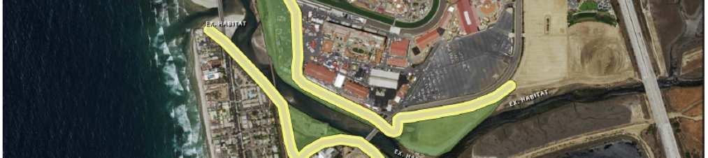
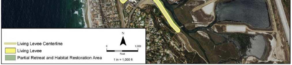
4 Figure 7.1 Living Levees Figure 7.2 Living Levee Cross Section
5 The levees would need to be planned and designed to avoid potential impacts to existing habitats, sediment transport, and flood levels upstream and downstream. By combining levees with partial retreat and habitat restoration, the intent would be to construct the levees in currently developed areas, avoid construction in existing wetland areas, and create new restored upland and wetland habitats that could mitigate for potential habitat impacts. The effects of levees and restored areas on river sediment transport, deposition, and scour during storm events would also need to be analyzed. For example, the effect of the San Dieguito Lagoon Restoration on sediment transport and the potential to reduce sand supply to the beach during storm events was an important consideration in the project evaluation and design. Constructing levees to protect portions of the City and Fairgrounds that would otherwise flood during storm events could potentially increase sand transport to the beach, however this would need to be fully evaluated. Confining river flows within a levee system also has the potential to increase flood levels upstream and downstream of the levee system, which would also need to be fully evaluated and addressed in planning and design. Within the levee system (i.e., between the levees), River flood levels would also likely increase and a plan and design to reduce any potential increase in flood risk to bridges crossing the river would need to be developed Adaptation option: raise structures The elevation of homes, buildings, and infrastructure such as roads can be raised to above river flood levels in the future, similar to the adaptation measure for raising structures to address North Beach coastal flooding. A key difference is that the area of potential river flooding is larger than the area of coastal flooding and a greater number of structures would need to be raised. Raising structures can include raising buildings on pile foundations and/or modifying building design/construction so that the second floor is above the target flood level and contains all flood-sensitive features, while the first floor is used for parking and/or storage and is designed to be durable and resilient to flood damage. Raising roads and vulnerable utilities can be accomplished by placing fill to rebuild roads and replace utilities at higher elevations. Other options for raising roads and utilities may include replacing at-grade roads with pile-supported causeways. As part of the City s existing floodplain management program, the City already requires that the construction or re-construction of North Beach buildings in the current river floodplain raise buildings above the existing 100-year river flood elevation to meet Federal Emergency Management Agency (FEMA) National Flood Insurance Program (NFIP) requirements. FEMA is in the process of revising the effective Flood Insurance Rate Maps and accompanying flood levels; however, the NFIP does not currently consider sea-level rise and climate change. The City can consider modifying floodplain development policies and regulations to address sealevel rise and facilitate the raising of structures over time through redevelopment Adaptation option: relocate structures The City can consider relocating public buildings, utilities, and other infrastructure as the river flood risk to public structures increases. For at-risk private property and structures, the City
6 could consider incentives for facilitating relocation to allow for wetland restoration along the river. As noted above, a greater number of structures are within the river flood risk area than the coastal flood risk area. The City can follow the development of state-wide retreat and relocation programs and pursue studies of how such programs could be implemented in the City of Del Mar. Options for facilitating structure removal could include rolling easements, relocation incentive programs, transfer of development rights programs, and programs for acquisition, buyout, or equity transfer of ownership in situations where doing so provides a commensurate public benefit. 7.2 River adaptation monitoring The monitored criteria for river adaptation are channel deposition (e.g., driven by sea-level rise) and the flood risk due to sea-level rise, channel deposition, and potential for climate change to increase extreme precipitation and river discharge. Table includes the projected increase in flood risk with sea-level rise/channel deposition and climate change from the Coastal Hazards, Vulnerability, and Risk Assessment (ESA 2016). These projections assume that deposition is not limited by sediment supply and that the river bed profile and flood profiles would increase in elevation with sea-level rise, with a rate and amount of deposition equal to the rate and amount of sea-level rise. Table Projected river flood risk with sea-level rise Sea-level rise and channel deposition 0 ft 1ft 2 ft 3 ft 5.5 ft Annual chance of extreme flooding (1% chance event) Annual chance of significant flooding (1980 event) 1% 5% 6% 6% 20% 5% 15% 25% 50% 100%
7 Table presents criteria to initiate planning for adaptation measures and anticipated extreme risk of flooding ranges over which measures will be effective. Based on the guiding principles, the flood risk criteria and thresholds are set to limit the risk of extreme river flooding and damage to less than 5% annual-chance of occurrence. Adaptation planning would be needed as river flooding and damage increases to 5%.The risk of more frequent, less severe, but still significant flooding such as the 1980 San Dieguito river flood event is estimated to currently be around 5% annual-chance. Adaptation to reduce extreme flood risk would reduce the risk of more frequent flooding. Table River flooding monitoring criteria to consider adaptation options Criteria & Thresholds Annual risk of extreme flooding* 5% 15% 50% 100% Protect Channel dredging Adaptation Options Accommodate Retreat *Risk of flooding without adaptations Raise structures Reservoir management Levee with partial retreat Relocate infrastructure 7.3 River adaptation coastal permitting As discussed previously, Coastal Development Permit review and approval for River adaptation measures may fall within the California Coastal Commission and/or the City s coastal permitting jurisdiction and, depending on the jurisdiction, may be processed through either the City of Del Mar s LCP and/or pursuant to the California Coastal Act. The likely coastal permitting mechanisms for River adaptation measures are summarized below for the purpose of informing the development of the LCP Amendment as a next step. The likely coastal permitting mechanisms for river adaptation measures are summarized in Table 7.3 for the purpose of informing the development of the LCP Amendment as a next step. Other approvals and permits would also be required and would need to be addressed separately. Table 7.3 Summary of likely California Coastal Act approval and permitting process for wetland adaptation measures Adaptation Measure LCP Jurisdiction CCC Jurisdiction River channel dredging Below water Reservoir management Partnering with City of San Diego Raise structures LCP redevelopment policies and regs. Relocate infrastructure LCP policies Note
CHAPTER 7. San Dieguito River Flooding Adaptation
 CHAPTER 7 San Dieguito River Flooding Adaptation This chapter includes a range of adaptation measures to address vulnerabilities from flooding along the San Dieguito River, including the river valley,
LETTER F. City of Del Mar
 LETTER F City of Del Mar F-1 The comment provides introductory statements and does not raise a specific issue related to the adequacy of the EIR. Therefore, no specific response is provided. F-2 The assumption
City of Del Mar Sea-Level Rise Adaptation Plan
 Revised Draft City of Del Mar Sea-Level Rise Adaptation Plan Del Mar, California Prepared for August 2016 updated May 2018 City of Del Mar Source: Robin Crabtree, March 8, 2016 Revised Draft City of Del
City of Del Mar Sea-Level Rise Adaptation Plan
 Revised Draft City of Del Mar Sea-Level Rise Adaptation Plan Del Mar, California Prepared for City of Del Mar Source: Robin Crabtree, March 8, 2016 Revised Draft City of Del Mar Sea-Level Rise Adaptation
5.2 HYDROLOGY EXISTING CONDITIONS. Regulatory Setting
 5.2 HYDROLOGY This section describes existing environmental conditions related to hydrology within the lagoon, within the project area specifically, at the disposal site, and at the beach placement sites.
Cost-Benefit Analysis for Sea Level Rise Adaptation Scenarios
 ARCCA Learning Session Cost-Benefit Analysis for Sea Level Rise Adaptation Scenarios Wednesday, March 21 st 1:00 2:00 PM PST Learning Session Agenda Webinar Logistics Brief overview of ARCCA Featured Presentation
Executive Summary. Executive Summary STAC Working Draft 11/21/2017
 Executive Summary STAC Working Draft 11/21/2017 Executive Summary The Adaptation Plan serves as the City s toolbox to help property owners (public and private) plan for and address future sea-level rise,
DRAFT Coastal Resiliency Technical Bulletin Page 1
 DRAFT Coastal Resiliency Technical Bulletin This guidance is intended to clarify how the Coastal Resiliency Goal and Objectives of the Regional Policy Plan (RPP) are to be applied and interpreted in Cape
APPENDIX G BIOLOGICAL SURVEY REPORT FOR THE SAN DIEGUITO LAGOON W-19 RESTORATION PROJECT
 APPENDIX G BIOLOGICAL SURVEY REPORT FOR THE SAN DIEGUITO LAGOON W-9 RESTORATION PROJECT San Dieguito Lagoon W-9 Restoration Project Draft EIR March 207 Appendices DRAFT BIOLOGICAL SURVEY REPORT FOR THE
APPENDIX G BIOLOGICAL SURVEY REPORT FOR THE SAN DIEGUITO LAGOON W-19 RESTORATION PROJECT
 APPENDIX G BIOLOGICAL SURVEY REPORT FOR THE SAN DIEGUITO LAGOON W-19 RESTORATION PROJECT San Dieguito Lagoon W-19 Restoration Project Final EIR November 2018 Appendices FINAL BIOLOGICAL SURVEY REPORT FOR
3.0 CUMULATIVE PROJECTS SCENARIO
 3.0 CUMULATIVE PROJECTS SCENARIO The CEQA Guidelines define cumulative impacts as two or more individual effects that, when considered together, are considerable or which compound or increase other environmental
4. Present Activities and Roles
 4. Present Activities and Roles The present missions, authorities, activities and roles of the various agencies involved with flood protection, floodplain management and flood-damage reduction are identified
City Pacifica Sea Level Rise Local Coastal Plan (LCP) Update
 Update") City Pacifica Sea Level Rise Local Coastal Plan (LCP) Update August 11, 2018 Public Workshop #5 1 Welcome and Introductions Meeting Objectives Provide an overview of the sea level rise planning process,
City Pacifica Sea Level Rise Local Coastal Plan (LCP) Update August 11, 2018 Public Workshop #5 1 Welcome and Introductions Meeting Objectives Provide an overview of the sea level rise planning process,
MATERIAL AMENDMENT STAFF REPORT AND PRELIMINARY RECOMMENDATION. Southern California Edison (SCE)
") STATE OF CALIFORNIA -- THE RESOURCES AGENCY CALIFORNIA COASTAL COMMISSION SAN DIEGO AREA 7575 METROPOLITAN DRIVE, SUITE 103 SAN DIEGO, CA 92108-4421 (619) 767-2370 W10a ARNOLD SCHWARZENEGGER, Governor
STATE OF CALIFORNIA -- THE RESOURCES AGENCY CALIFORNIA COASTAL COMMISSION SAN DIEGO AREA 7575 METROPOLITAN DRIVE, SUITE 103 SAN DIEGO, CA 92108-4421 (619) 767-2370 W10a ARNOLD SCHWARZENEGGER, Governor
Lower San Joaquin River Feasibility Study PLAN FORMULATION ADDENDUM
 PLAN FORMULATION ADDENDUM Non-Structural Measure Descriptions Elevate Critical Infrastructure This measure would raise at-risk critical structures above the design inundation level. Elevation would be
VEGETATIVE, WATER, FISH AND WILDLIFE RESOURCES POLICIES
 VEGETATIVE, WATER, FISH AND WILDLIFE RESOURCES POLICIES The County will: GOALS AND OBJECTIVES 1.1 Conserve, Enhance, Protect, Maintain and Manage Vegetative, Water, Fish and Wildlife Resources Promote
ERIC D. STEIN SOUTHERN CALIFORNIA COASTAL WATER RESEARCH PROJECT
 Effect of Sea Level Rise on Coastal Wetlands ERIC D. STEIN SOUTHERN CALIFORNIA COASTAL WATER RESEARCH PROJECT Sea level rise presents substantial challenges to managing wetlands and other coastal resources
GOAL 1: To preserve, restore, and enhance coastal resources to maximize public use and assure their future ecological benefit.
 GOALS, OBJECTIVES, AND POLICIES GOAL 1: To preserve, restore, and enhance coastal resources to maximize public use and assure their future ecological benefit. Objective 1.1: To maintain and upgrade the
DRAINAGE AND NATURAL AQUIFER GROUNDWATER RECHARGE ELEMENT
 Goal 7.0. To optimize integrated stormwater management in order to reduce damage and impacts from sea level rise and flooding, promotes recharge to the Surficial Aquifer System (SAS), improve and protect
Project Alternatives: The Parsons Sill Project History
 Project Alternatives: The Parsons Sill Project History Project Impetus Over the past 150 years, human actions have altered the tidal, freshwater, and sediment processes that are essential to support and
FROM TIDES TO STORMS: PREPARING FOR NEW HAMPSHIRE S FUTURE COAST
 FROM TIDES TO STORMS: PREPARING FOR NEW HAMPSHIRE S FUTURE COAST Seabrook - Hampton Falls Hampton - North Hampton Rye - New Castle - Portsmouth Assessing the Risk and Vulnerability of NH Coastal Communities
RE: Recommendations for Staged Implementation of Alternative 3a
 March 10, 2006 Ms. Julie Thomas Coastal San Luis Resource Conservation District 545 Main Street, Suite B-1 Morry Bay, Ca 93442 RE: Recommendations for Staged Implementation of Alternative 3a Dear Ms. Thomas,
Missouri River Flood Response Activity
 For the purpose of compliance with the National Environmental Policy Act (NEPA), the categorical exclusions identified in this table are potentially applicable to flood recovery efforts. The following
LETTER G. City of San Diego
 LETTER G City of San Diego G-1 The comment provides introductory statements and acknowledges collaboration between interested stakeholders and agency representatives in the development of the proposed
Collaboration: Sea Level Marin Adaptation Response Team Phase II
 Collaboration: Sea Level Marin Adaptation Response Team Phase II 2018-2020 Scope of Work Background Climate experts estimate that by 2100, sea level could rise by up to 70 inches, though recent projections
Federal Clean Water Act/National Pollutant Discharge Elimination System
 4.6 HYDROLOGY AND FLOODPLAIN This section evaluates potential environmental effects related to hydrology and floodplain issues associated with the Proposed Action. Two technical studies related to these
Pajaro River Watershed Flood Prevention Authority. Phase 3 and 4a. Pajaro River Watershed Study
 Pajaro River Watershed Flood Prevention Authority Phase 3 and 4a FEBRUARY 2005 Funding for this project has been provided in full or in part through a contract with the SWRCB pursuant to the Costa-Machado
ACKNOWLEDGEMENTS. Sincerely, Executive Director and Staff. Rockingham Planning Commission. 156 Water Street Exeter, NH (603)
") ACKNOWLEDGEMENTS The gratefully acknowledges the participation of coastal New Hampshire municipalities in the preparation of this report: City of Portsmouth Town of New Castle Town of Rye Town of North
ACKNOWLEDGEMENTS The gratefully acknowledges the participation of coastal New Hampshire municipalities in the preparation of this report: City of Portsmouth Town of New Castle Town of Rye Town of North
Project Information. Pursuant to Section 404 of the Clean Water Act (33 U.S. Code 1344), notice is hereby given that
, notice is hereby given that") US ARMY Corps Of Engineers Little Rock District JOINT PUBLIC NOTICE CORPS OF ENGINEERS STATE OF MISSOURI Application Number: SWL 2013-00260 Date: April 15, 2014 Comments Due: May 6, 2014 TO WHOM IT MAY
US ARMY Corps Of Engineers Little Rock District JOINT PUBLIC NOTICE CORPS OF ENGINEERS STATE OF MISSOURI Application Number: SWL 2013-00260 Date: April 15, 2014 Comments Due: May 6, 2014 TO WHOM IT MAY
Freight Street Development Strategy
 Freight Street Development Strategy Appendix B: Naugatuck River Floodplain Analysis Freight Street Development Strategy DECEMBER 2017 Page B-1 1.0 NAUGATUCK RIVER FLOODPLAIN AT FREIGHT STREET 1.1 Watershed
County of San Diego DEPARTMENT OF PARKS AND RECREATION. Administrative Office: (858) Fax: (858) Reservations: (858)
 Fax: (858) Reservations: (858)") BRIAN ALBRIGHT DIRECTOR County of San Diego DEPARTMENT OF PARKS AND RECREATION Administrative Office: (858) 694-3030 Fax: (858) 495-5841 Reservations: (858) 565-3600 www.sdparks.org NOTICE OF PREPARATION
BRIAN ALBRIGHT DIRECTOR County of San Diego DEPARTMENT OF PARKS AND RECREATION Administrative Office: (858) 694-3030 Fax: (858) 495-5841 Reservations: (858) 565-3600 www.sdparks.org NOTICE OF PREPARATION
Presentation Overview
 Little Dry Creek Restoration Deep River Flood Risk Management Final Presentation to LCRBDC June 10, 2015 Presentation Overview Project Overview & Background Information Data Collection Model Development
Marin Countywide Sea Level Rise Planning
 Shoreline Highway at Highway Photo 101. Credit: Jeff Caltrans Wong Marin Countywide Sea Level Rise Planning B A Y W A V E A N D C S M A R T V U L N E R A B I L I T Y A S S E S S M E N T S Tidal Flooding
How wetlands can help us adapt to rising seas
 University of Wollongong Research Online Faculty of Science, Medicine and Health - Papers Faculty of Science, Medicine and Health 2014 How wetlands can help us adapt to rising seas Kerrylee Rogers University
TPAC STAFF REPORT. California Coastal Commission Draft Sea-Level Rise Policy Guidance. MEETING DATE: February 6, 2014 AGENDA ITEM: 7
 TPAC STAFF REPORT SUBJECT: California Coastal Commission Draft Sea-Level Rise Policy Guidance MEETING DATE: February 6, 2014 AGENDA ITEM: 7 STAFF CONTACT: Brian Bresolin, Peter Imhof RECOMMENDATION: Review
Ecotourism Business Owner
 Local Resident You have been selected to represent your community on this issue. Your community is a beach community. Members of your community enjoy living where they do because they enjoy seeing wildlife
Information for File # RMM
 Information for File # 20-084-R Applicant: Mr. Paul Nelson Corps Contact: Ryan Malterud Address: 80 Fifth Street East, St. Paul, Minnesota 550 E-Mail: Ryan.M.Malterud@usace.army.mil Phone: (5) 290-528
Atlantic Coast of New York East Rockaway Inlet to Rockaway Inlet and Jamaica Bay, NY
 Atlantic Coast of New York East Rockaway Inlet to Rockaway Inlet and Jamaica Bay, NY Draft Reformulation Public Information October 2016 US Army Corps of Engineers Presentation Outline Project Overview
The success of Gwinnett County s Floodplain Management Program can be directly attributed to Dewberry s innovation and quality.
 Water Resources With severe storms, droughts, and ever-expanding urban centers, water resources issues have become increasingly complex. We work with our clients to find innovative and cost-effective solutions
Damage-Resistant Practices for Designing Septic Systems in Coastal High Hazard Areas
 Damage-Resistant Practices for Designing Septic Systems in Coastal High Hazard Areas Guidance and recommendations for design professionals, permitting officials, and coastal property owners Septic systems
Sea Level Rise Adaptation Options for Local Governments. Robert E. Deyle Department of Urban and Regional Planning Florida State University
 Sea Level Rise Adaptation Options for Local Governments Robert E. Deyle Department of Urban and Regional Planning Florida State University Impacts of Sea Level Rise 1. Inundation and shoreline recession
5.0 PRELIMINARY ENVIRONMENTAL REVIEW
 5.0 PRELIMINARY ENVIRONMENTAL REVIEW 5.1 INTRODUCTION A preliminary environmental review was performed on the proposed freeway improvements that form Concept C, which encompasses the three freeway corridors
Appendix B Stormwater Site Plan Submittal Requirements Checklist
 Stormwater Site Plan Submittal Requirements Checklist The Submittal Requirements Checklist is intended to aid the design engineer in preparing a Stormwater Site Plan. All items included in the following
C-SMART: Planning for Sea Level Rise in Tomales Bay, September 23, 2016 Jack Liebster, Planning Manager, Marin County
 C-SMART: Planning for Sea Level Rise in Tomales Bay, September 23, 2016 Jack Liebster, Planning Manager, Marin County Sustainable Marin? Sea Level Rise Adaptation Process Evaluate Science Info. Implement
Climate Change Impacts on Joint Riverine and Coastal Flooding on Calleguas Creek in Ventura County, CA
 Climate Change Impacts on Joint Riverine and Coastal Flooding on Calleguas Creek in Ventura County, CA James Gregory, James Jackson (ESA) Lily Verdone (TNC) FMA, September 8, 2016 Project Overview Coastal
Virginia Beach Comprehensive Sea Level Rise and Recurrent Flooding Planning Study
 1 Virginia Beach Comprehensive Sea Level Rise and Recurrent Flooding Planning Study Policy Recommendations and City-wide Flood Protection Strategies January 15, 2019 2 Agenda Project Overview Hazards and
Matrix of Potential Coastal Adaptation Strategies
 Matrix of Potential Coastal Adaptation Strategies The matrix provided on pages 60-76, developed by Lesley Ewing (California Coastal Commission) and Dr. Reinhard Flick, outlines some of the most common
Appendix D - Evaluation of Interim Solutions
 Appendix D - Evaluation of Interim Solutions D.1 Introduction The implementation of long-term improvements is projected to take 5 to 8 years. To reduce the number of years of flooding impacts, the partner
Coastal and River Flooding Events
 Coastal and River Flooding Events A Discussion Paper about Community Resilience November 2015 Brief: Warmer temperatures are reducing winter snow accumulations at higher elevations, increasing storm intensity
Environmental Check List Georgia Environmental Policy Act
 Environmental Check List Georgia Environmental Policy Act Project No. : Project Name: GEORGIA IS AREA AFFECTED? IF AFFECTED, HOW SEVERELY? AREA/CATEGORY NO YES UNKNOWN MINOR MEDIAN MAJOR UNKNOWN 1. Wetlands
Draft Environmental Impact Report
 Revised Draft Environmental Impact Report San Francisquito Creek Flood Protection, Ecosystem Restoration, and Recreation Project Upstream of Highway 101 This notice announces that a Draft Environmental
Collaboration: Sea-level Marin Adaptation Response Team (C-SMART)
") Collaboration: Sea-level Marin Adaptation Response Team (C-SMART) Photo Credit : Lighthawk Aerial 3501 Civic Center Drive, Rm. 308 San Rafael, CA 94903 415 4736269 T www.marinslr.org Marin County Board
Collaboration: Sea-level Marin Adaptation Response Team (C-SMART) Photo Credit : Lighthawk Aerial 3501 Civic Center Drive, Rm. 308 San Rafael, CA 94903 415 4736269 T www.marinslr.org Marin County Board
CITY OF SAN DIEGO COMMENTS ON THE SAFARI HIGHLANDS RANCH PROJECT (SUB ).
.") Attn: John Helmer 201 North Broadway Escondio, CA 92025 Submitted via email to: Jhelmer@escondido.org Subject: CITY OF SAN DIEGO COMMENTS ON THE SAFARI HIGHLANDS RANCH PROJECT (SUB 15-0019). The City of
Attn: John Helmer 201 North Broadway Escondio, CA 92025 Submitted via email to: Jhelmer@escondido.org Subject: CITY OF SAN DIEGO COMMENTS ON THE SAFARI HIGHLANDS RANCH PROJECT (SUB 15-0019). The City of
CHAPTER 3. PLANNING BASIC: LAND USE PLANNING AND ZONING
 CHAPTER 3. PLANNING Communities use planning to direct development and public projects and ensure their land use regulations (zoning) meet the community s needs. When done correctly, planning can prevent
Appendix M. Summary of Local Sea Level Rise Planning Efforts. Draft
 Appendix M Summary of Local Sea Level Rise Planning Efforts Appendix M: Summary of Local Sea Level Rise Planning Efforts Summary of Local Sea Level Rise Planning Efforts Half Moon Bay SLR Planning Efforts
APPENDIX G DIVERSION AND PELICAN LAKE CUTOFF CHANNELS HYRAULICS AND BRIDGE TECHNICAL MEMORANDUM
 APPENDIX G DIVERSION AND PELICAN LAKE CUTOFF CHANNELS HYRAULICS AND BRIDGE TECHNICAL MEMORANDUM To: File Memo From: Matt Redington, P.E. Project: Watertown South Connector CC: Date: March 6, 2007; revised
CITY OF EUREKA. Potential tidal inundation based on sea level rise projections for 2100: low 2.1 feet and high 5.4 feet.
 CITY OF EUREKA Potential tidal inundation based on sea level rise projections for 2100: low 2.1 feet and high 5.4 feet. Sea Level Rise Adaptation Planning Report Prepared By Aldaron Laird Trinity Associates
COASTAL CONSERVANCY. Staff Recommendation May 24, 2007 NORTH SAN DIEGO COUNTY COASTAL WATERSHEDS HYDROLOGIC MONITORING NETWORK
 COASTAL CONSERVANCY Staff Recommendation May 24, 2007 NORTH SAN DIEGO COUNTY COASTAL WATERSHEDS HYDROLOGIC MONITORING NETWORK File No. 07-030-1 Project Manager: Deborah Ruddock RECOMMENDED ACTION: Authorization
EXHIBIT # ATTACHMENT #
 EXHIBIT # ATTACHMENT # Proposed Text Amendment to the Broward County Land Use Plan II. GOALS, OBJECTIVES AND POLICIES SMART GROWTH, AND GREEN/ENERGY EFFICIENT AND SUSTAINABLE LAND USE PATTERNS GOAL A.00.00
ATTACHMENT 1 GEPA CHECKLIST & Historical Archeological & Natural Heritage Preservation Documents
 ATTACHMENT 1 GEPA CHECKLIST & Historical Archeological & Natural Heritage Preservation Documents INTRODUCTION The 1991 Session of the Georgia General Assembly passed Senate Bill 97, as amended, and it
DESIGN GRADING AND EROSION CONTROL A. Slope Criteria
 Section 5. DESIGN GRADING AND EROSION CONTROL A. Slope Criteria Earthen slopes shall conform to the following: Maximum slope should not be steeper than 6:1 (horizontal to vertical) unless protected from
Sea Level Rise Impacts on Municipal Stormwater Systems in Hampton Roads
 VIRGINIA D.C. MARYLAND CHAPTER Sea Level Rise Impacts on Municipal Stormwater Systems in Hampton Roads Presentation at the APWA Mid-Atlantic Chapter May Regional Conference Virginia Beach, Virginia May
Appendix K Civil Engineering
 Appendix K Civil Engineering Fargo-Moorhead Metropolitan Area Flood Risk Management Final Feasibility Report and Environmental Impact Statement Prepared by: U.S. Army Corps of Engineers St. Paul District
Clallam County Shoreline Master Program (SMP) Update
 Update") Title Level 1 Title Level 2 Clallam County Shoreline Master Program (SMP) Update Clallam County Board of County Commissioners October 30, 2017 Clallam County Shoreline Master Program: In effect for Over
Title Level 1 Title Level 2 Clallam County Shoreline Master Program (SMP) Update Clallam County Board of County Commissioners October 30, 2017 Clallam County Shoreline Master Program: In effect for Over
SECTION 7.0 PROJECT FEASIBILITY, ENGINEER S RECOMMENDATION AND DESIGN ISSUES NEEDING RESOLUTION
 SECTION 7.0 PROJECT FEASIBILITY, ENGINEER S RECOMMENDATION AND DESIGN ISSUES NEEDING RESOLUTION 7.1 PROJECT FEASIBILITY The determination of project feasibility is based upon several criteria established
Environmental Protection Update Stormwater and Floodplain. February 2, 2017
 Environmental Protection Update Stormwater and Floodplain Glen Behrend, P.E. 2017 GA Zoning Conference February 2, 2017 INTRODUCTION Today s discussion: Stormwater Overview Stormwater and Smart Growth
CITY OF EUREKA. Potential tidal inundation based on sea level rise projections for 2100: low 2.1 feet and high 5.4 feet.
 CITY OF EUREKA Potential tidal inundation based on sea level rise projections for 2100: low 2.1 feet and high 5.4 feet. Sea Level Rise Adaptation Planning Report December 2016 Acknowledgements Funding
acquiring, managing, and disposing of federal lands and facilities;
 2.2.1 HYDROLOGY AND FLOODPLAIN This section discusses and analyzes the surface hydrology and water quality characteristics of the project. The information provided in this section is based on the Preliminary
County of San Mateo Planning and Building Department
 County of San Mateo Planning and Building Department Coastal Development Permit EXEMPTION/EXCLUSION WORKSHEET (Categorical Exclusion Order E-81-1) (This is not a Certificate of Exemption) To be used by
Appendix P. U.S. Fish and Wildlife Service Planning Aid Letter
 Appendix P U.S. Fish and Wildlife Service Planning Aid Letter This page is intentionally left blank. United States Department of the Interior FISH AND WILDLIFE SERVICE Missouri Ecological Services Field
IV. ENVIRONMENTAL IMPACT ANALYSIS G. HYDROLOGY/WATER QUALITY
 IV. ENVIRONMENTAL IMPACT ANALYSIS G. HYDROLOGY/WATER QUALITY ENVIRONMENTAL SETTING The project site is located in the Wilshire community of the City of Los Angeles and is bound by S. Wetherly Drive to
New Castle County, DE. Floodplain Regulations
 New Castle County, DE Floodplain Regulations John J. Gysling, PE CFM Department of Land Use New Castle County, DE February 26, 2009 Today s Presentation Floodplain Protection and Uses Terms and Definitions
OFFICE OF STRUCTURES MANUAL ON HYDROLOGIC AND HYDRAULIC DESIGN CHAPTER 3 POLICY AND PROCEDURES
 OFFICE OF STRUCTURES MANUAL ON HYDROLOGIC AND HYDRAULIC DESIGN CHAPTER 3 POLICY AND PROCEDURES April 28, 2016 Table of Contents 3.1 Introduction... 2 3.1.1 Purpose of Chapter 3... 2 3.1.2 Policy vs. Design
COASTAL CONSERVANCY. Staff Recommendation March 25, 2004 NCCP PROGRAM IMPLEMENTATION: SAN DIEGO RIVER CALMAT PROPERTY PHASE 2
 COASTAL CONSERVANCY Staff Recommendation March 25, 2004 NCCP PROGRAM IMPLEMENTATION: SAN DIEGO RIVER CALMAT PROPERTY PHASE 2 File No. 03-137 Project Manager: Marc Beyeler RECOMMENDED ACTION: Authorization
Coastal and River Flooding Events
 Coastal and River Flooding Events A Discussion Paper about Community Resilience January 2016 Brief: Warmer temperatures are reducing winter snow accumulations at higher elevations, increasing storm intensity
REMOVING/RELOCATING DRAINAGE LIFT STATIONS
 MINNESOTA WETLAND RESTORATION GUIDE REMOVING/RELOCATING DRAINAGE LIFT STATIONS TECHNICAL GUIDANCE DOCUMENT Document No.: WRG 4A-5 Publication Date: 10/14/2015 Table of Contents Introduction Application
Applicant s Proposed Mitigation Statements Seward Highway 75-90, POA , Turnagain Arm Phase 1 May 2017
 Applicant s Proposed Mitigation Statements Seward Highway -, POA 2013-448, Turnagain Arm Phase 1 May 2017 Avoidance The project is geographically constrained by Turnagain Arm tidal mudflats on one side
SURREY COASTAL FLOOD ADAPTATION STRATEGY (CFAS) South Nicomekl Irrigation Meeting November 2 nd, 2016
 South Nicomekl Irrigation Meeting November 2 nd, 2016") SURREY COASTAL FLOOD ADAPTATION STRATEGY (CFAS) South Nicomekl Irrigation Meeting November 2 nd, 2016 Project What overview is it? STUDY AREA A 3 year project to help prepare Surrey for a changing climate
SURREY COASTAL FLOOD ADAPTATION STRATEGY (CFAS) South Nicomekl Irrigation Meeting November 2 nd, 2016 Project What overview is it? STUDY AREA A 3 year project to help prepare Surrey for a changing climate
Southern Watersheds Responses to Sea Level Rise. Back Bay-North Landing-Currituck-Albemarle Sound
 Southern Watersheds Responses to Sea Level Rise Back Bay-North Landing-Currituck-Albemarle Sound About Extremes: Climate Change and Storms More storm intensity Increasing rainfall Extratropical cyclones
12 DRAINAGE General Administrative Requirements Standards
 12 DRAINAGE 12.1 General The Design-Builder shall conduct all Work necessary to meet the requirements associated with drainage, including culverts, bridge hydraulics, roadway ditches, and closed storm
EXHIBIT # ATTACHMENT #
 EXHIBIT # ATTACHMENT # Proposed Text Amendment to the Broward County Land Use Plan II. GOALS, OBJECTIVES AND POLICIES SMART GROWTH AND GREEN/ENERGY EFFICIENT AND SUSTAINABLE LAND USE PATTERNS GOAL A.00.00
Public Notice ISSUED: March 1, 2016 EXPIRES: March 31, 2016
 APPLICANT: City of Arcadia Public Notice ISSUED: March 1, 2016 EXPIRES: March 31, 2016 REFER TO: MVP-2011-01963-EMN SECTION: 404 - Clean Water Act 1. APPLICATION FOR PERMIT TO discharge fill material within
APPENDIX M MITIGATION STRATEGY For WESTMINSTER, EAST GARDEN GROVE FLOOD RISK MANAGEMENT STUDY
 APPENDIX M MITIGATION STRATEGY For WESTMINSTER, EAST GARDEN GROVE FLOOD RISK MANAGEMENT STUDY October 2018 Page intentionally left blank Table of Contents: 1.0 Introduction... 5 1.1 Study Area... 5 1.2
STREAM AND BUFFER AREA PROTECTION/RESTORATION
 STREAM AND BUFFER AREA PROTECTION/RESTORATION AMENDMENT OPTIONS TO STRENGTHEN POLICY IN HEADWATERS AREAS DRAFT SUBSEQUENT TO THE JANUARY 25, 2007 MEETING OF THE PLANNING COMMISSION ENVIRONMENT COMMITTEE
To: From: Date: Subject: Sherwood Lakes Drainage Alternatives Analysis 1
 To: From: The City of Virginia Beach Lewis White and Rachael Johnson on behalf of WSP Date: June 6, 2017 Subject: s Drainage Alternatives Analysis This memorandum represents the summary of findings from
Vulnerability Assessment
 Brief coastal vulnerability assessment for the City of Cocoa Beach, conducted utilizing available NOAA and UF GeoPlan tools. Vulnerability Assessment City of Cocoa Beach East Central Florida Regional Planning
ENVIRONMENTAL IMPACT STATEMENT CLEVELAND HARBOR, CUYAHOGA COUNTY, OHIO DREDGED MATERIAL MANAGEMENT PLAN PUBLIC SCOPING INFORMATION PACKET
 ENVIRONMENTAL IMPACT STATEMENT CLEVELAND HARBOR, CUYAHOGA COUNTY, OHIO DREDGED MATERIAL MANAGEMENT PLAN PUBLIC SCOPING INFORMATION PACKET March 16, 2006 ANNOUNCEMENT OF PUBLIC SCOPING MEETINGS The U.S.
7/11/2018. Floodplain Management Association - June 14, 2018 luncheon
 7/11/2018 Floodplain Management Association - June 14, 2018 luncheon Len Materman Executive Director San Francisquito Creek Joint Powers Authority len@sfcjpa.org 650-324-1972 San Francisquito Creek 1998
1.0 REQUEST. SANTA BARBARA COUNTY PLANNING COMMISSION Determination of Flood Control Easement in Carpinteria Marsh
 SANTA BARBARA COUNTY PLANNING COMMISSION 65402 Determination of Flood Control Easement in Carpinteria Marsh Deputy Director: Dave Ward Staff Report Date: April 11, 2008 Division: Development Review South
Ponds. Pond A water impoundment made by excavating a pit, or constructing a dam or an embankment.
 POND SITE SELECTION AND CONSTRUCTION Uses, Planning, & Design David Krietemeyer Area Engineer USDA-NRCS June 20, 2008 Uses Considerations for Location of Commonly Used Terms Pond A water impoundment made
EVALUATION - SECTION 404 OF THE CLEAN WATER ACT DISCHARGE OF SEDIMENTS FROM OR THROUGH A DAM
 EVALUATION - SECTION 404 OF THE CLEAN WATER ACT DISCHARGE OF SEDIMENTS FROM OR THROUGH A DAM U.S. ARMY CORPS OF ENGINEERS, NEW ENGLAND DISTRICT CONCORD, MA PROJECT: Northfield Brook Dam, Naugatuck River
New Jersey Department of Environmental Protection
 New Jersey Department of Environmental Protection Assistant Commissioner Marilyn Lennon Land Use Management Division of Land Use Regulation Manager Virginia Kopkash September 16, 2013 Transformation of
Planning for Resilience: Preparing Florida Communities. January 28, 2015
 Planning for Resilience: Preparing Florida Communities January 28, 2015 Qualities of Consequence 4 th largest economy in US 3 rd most populous state 18 sea ports Vital trade and transportation systems
Appendix M. Criteria, Measures and Indicators for Effects Assessment
 Appendix M Criteria, Measures and Indicators for Effects Assessment Appendix M. Criteria, Measures and Indicators for Effects Assessment Objective 1: Naturalization Changes to Aquatic Habitat Disruption,
NUMERICAL MODELING IN THE WATER ENVIRONMENT
 NUMERICAL MODELING IN THE WATER ENVIRONMENT Capabilities and Experience Noble Consultants, Inc. NUMERICAL MODELING SERVICES IN THE WATER ENVIRONMENT NCI utilizes the most advanced numerical models in the
ATTN: Regulatory Office 1645 South 101 st East A venue Tulsa, OK
 Public Notice U.S. Army Corps of Engineers Tulsa District Reply To: U.S. Army Corps of Engineers ATTN: Regulatory Office 1645 South 101 st East A venue Tulsa, OK 74128-4609 SWT-2013-179 Public Notice No.
Calleguas Creek Watershed Wetland Restoration Plan. David L. Magney. David Magney Environmental Consulting
 Calleguas Creek Watershed Wetland Restoration Plan David L. Magney David Magney Environmental Consulting Calleguas Creek Watershed About the Watershed Located in southeastern Ventura County Drains 343
Phase II: Construction (See Appendix 1 for figures and photos)
") Phase I- Complete: Plan Design, Compliance and Baseline Monitoring Audubon and San Pablo Bay National Wildlife Refuge (Refuge) staff completed approximately 2 years of pre-construction monitoring including
Phase I- Complete: Plan Design, Compliance and Baseline Monitoring Audubon and San Pablo Bay National Wildlife Refuge (Refuge) staff completed approximately 2 years of pre-construction monitoring including
Conceptual Design and Feasibility of a Natural Fishway at the Fremont BART Weir, Alameda Creek, California
 Conceptual Design and Feasibility of a Natural Fishway at the Fremont BART Weir, Alameda Creek, California Final Report September 2005 Prepared by Center for Ecosystem Management and Restoration, Oakland,