WETLAND ANALYSIS REPORT. POINT NO POINT WETLAND HANSVILLE Kitsap County, Washington
|
|
|
- Franklin Francis
- 5 years ago
- Views:
Transcription
1 WETLAND ANALYSIS REPORT FOR THE POINT NO POINT WETLAND HANSVILLE Kitsap County, Washington Prepared For: Kitsap County Department of Surface and Storm Water Management 614 Division Street, MS-26 Port Orchard, WA Prepared By: Wiltermood Associates, Inc SW Harper Road Port Orchard, WA (360) April 30, 2013
2 TABLE OF CONTENTS PAGE EXECUTIVE SUMMARY 1 PROPERTY OWNERSHIP AND EXISTING DEVELOPMENT 2 CRITICAL AREAS MAPPING 3 Kitsap County Soil Survey 3 National Wetlands Inventory 3 Washington Department of Natural Resources, Forest Practices Application Review System 3 Priority Species 3 WETLAND DELINEATION METHODOLOGY 4 WETLAND ASSESSMENT 4 Wetland Delineation and Data Description 5 Aerial Wetland Boundary Delineation and Description 5 Point No Point Wetland Vegetation Communities Saltmarsh/Coastal Lagoon 6 Point No Point Wetland Vegetation Communities Freshwater Emergent and Forested 6 Wetland Boundary Delineation-Flagged Areas 7 Tide Gate Delineation 7 North Wetland Boundary-Flags North Wetland Boundary-Flags North Wetland Boundary-Flags North Wetland Boundary-Flags North Wetland Boundary-Flags Hydrology 12 Coastal Lagoon-Hydrologic Conditions 12 Salinity 12 Freshwater Inputs 13 Stream Conditions 13 Flooding 13 Wetland Category 13 Wildlife Habitat 15 RESTORATION AND FLOOD ATTENUATION POTENTIAL 15 LIMITATIONS 16 REFERENCES 17
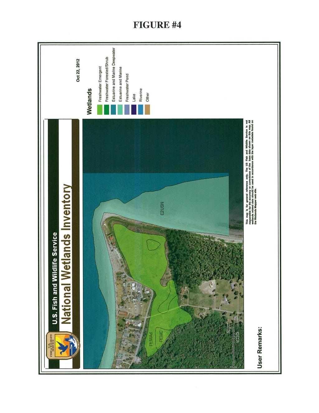
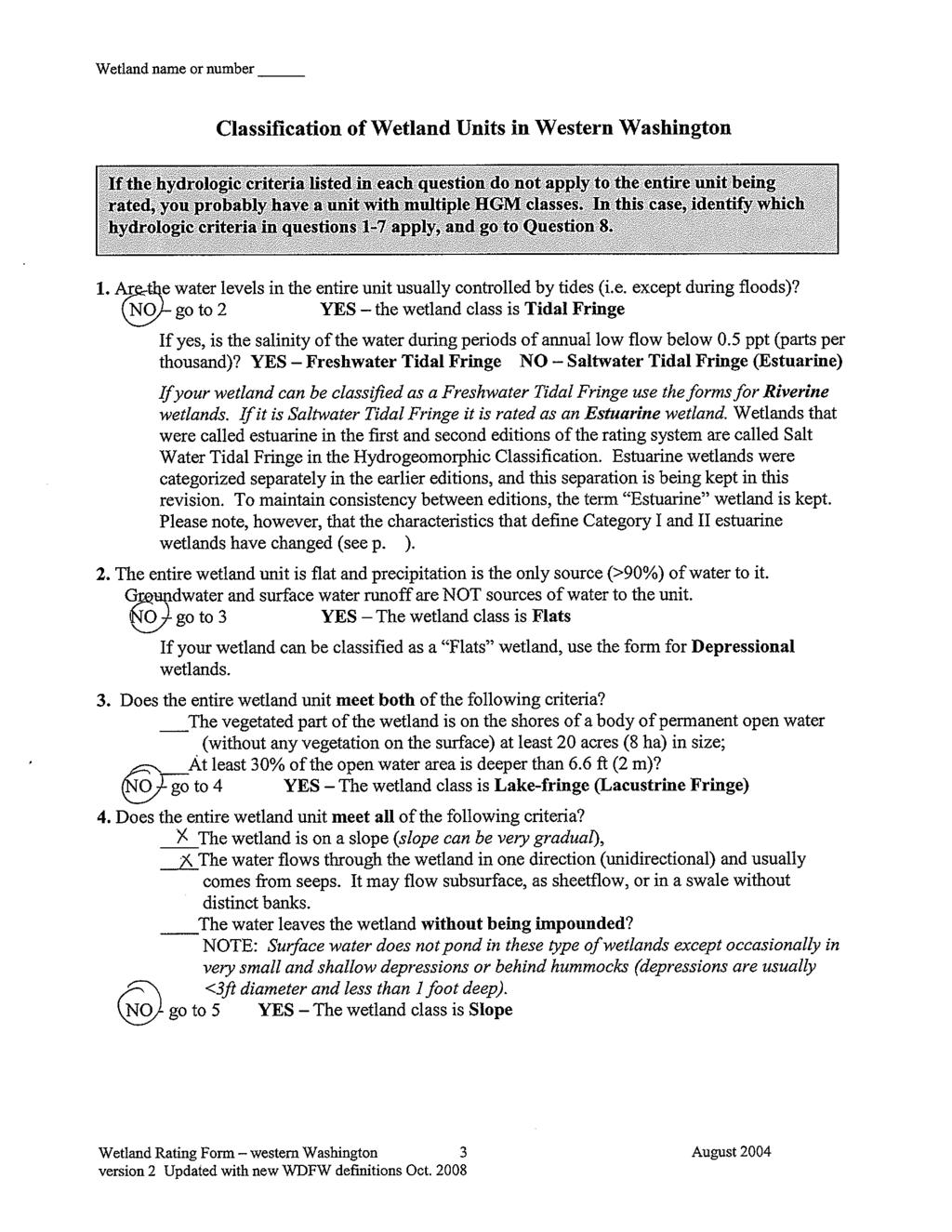
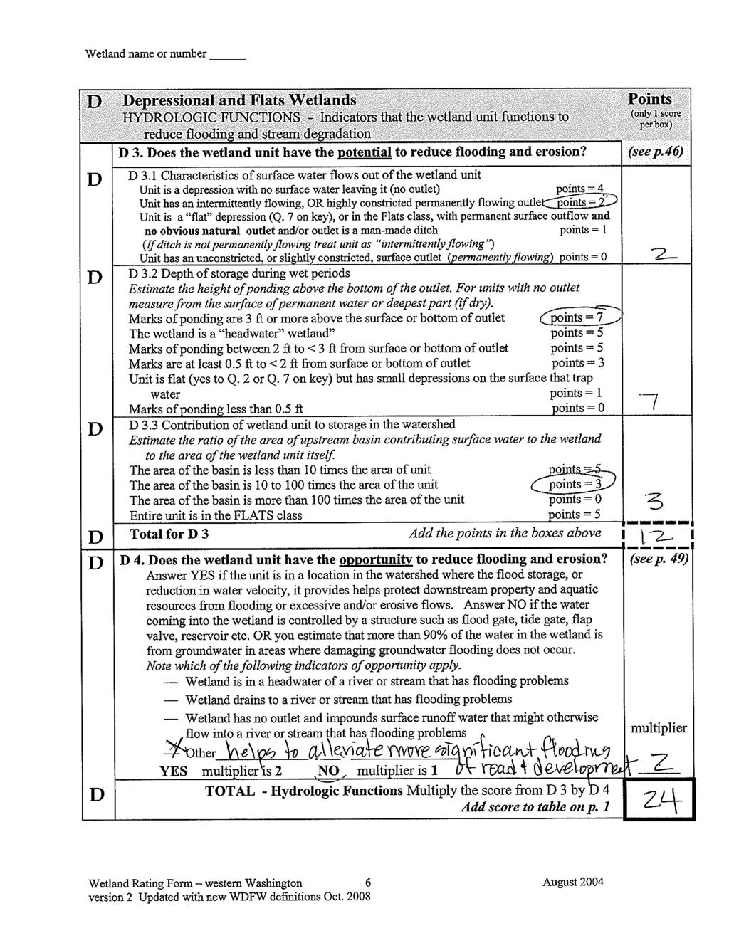
3 FIGURES AND ATTACHMENTS Figure #1 Vicinity and Property Ownership Map Figure #2a Rough Wetland Boundary Delineation-NWB Flags 1-14 Figure #2b Rough Wetland Delineation Map-Tide Gate and NWB flags Figure #3 Web Soil Survey Map Figure #4 On Line Wetlands Mapper Map Figure #5 Washington DNR Forest Practices Application Review System Map Figure #6 Aerial Wetland Delineation Mapping Figure #7 Coastal Lagoon Aerial Mapping Figure #8 Salinity Aerial Mapping Figure #9 Freshwater Influence Mapping Attachment #1 Attachment #2 Attachment #3 Attachment #4 Attachment #5 Wetland Photos Wetland Delineation Data Forms Wetland Rating Form Wetland Delineation Methodology Plant Indicator Status
4

5
6

7

8
9

10
11

12

13

14

15

16

17

18
19
20 REFERENCES Cowardin, L., F. Golet, V. Carter. and E. LaRoe. Classification of Wetlands and Deepwater Habitat of the United States. U.S. Fish and Wildlife Service, FWS/OBS 79/ pp. Environmental Laboratory. Corps of Engineers Wetlands Delineation Manual. January pp. plus appendices Guard, B. Jennifer. Wetland Plants of Oregon and Washington. Lone Pine Publishing pp. Hitchcock, Leo C. and Cronquist, Arthur. Flora of the Pacific Northwest. University of Washington Press pp. Hruby, T Wetland Rating System for Western Washington-Revised. Washington State Department of Ecology Publication Number August Hruby, T Wetland Rating System for Western Washington-Revised. Washington State Department of Ecology Publication Number , Version 2, Updated October Kitsap County Critical Areas Ordinance. Adopted December 1, Lyons, C.P and Merilees, Bill. Trees, Shrubs, and Flowers To Know in Washington and British Columbia. Lone Pine Publishing pp. Munsell Color. Munsell Soil Color Charts. Macbeth, a Division of Kollmorgen Corporation Revised Edition. Baltimore, MD. Pojar, Jim and MacKinnon, Andy. Plants of the Pacific Northwest Coast; Washington, Oregon, British Columbia, & Alaska. Lone Pine Publishing pp. Speare-Cooke, Sarah. A Field Guide to the Common Wetland Plants of Western Washington and Northwestern Oregon. Seattle Audubon Society pp. U.S. Army Corps of Engineers Regional Supplement to the Corps of Engineers Wetland Delineation Manaul: Western Mountains, Valleys and Coast Region, ed. JS Wakeley, RW Lichvar, and CV Noble. ERDC/ELTR Vicksburg, MS; US Army Engineer Research and Development Center. 14
21 REFERENCE, continued US Army Corps of Engineers. Wetland Plants of the Pacific Northwest. September, pp. United States Department of Agriculture, Natural Resources Conservation Service, Field Indicators of Hydric Soils in the United States, Version 7.0. G.W. Hurt and L.M. Vasilas (eds.). USDA, NRCS, in cooperation with the National Technical Committee for Hydric Soils. US Department of Agriculture. Natural Resources Conservation Service. Web Soil Survey. US Department of Agriculture. Natural Resources Conservation Service. Plant Database. US Department of Agriculture, Soil Conservation Service. Soil Survey of Kitsap County Area, Washington. September, US Environmental Protection Agency. Wetlands Evaluation Technique (WET): Volume I: Literature Review and Evaluation Rationale. October 1991 US Fish and Wildlife Service. National List of Plant Species That Occur In Wetlands: 1988 National Summary. September, pp. U.S. Fish and Wildlife Service. National List of Plant Species that Occur in Wetlands, Northwest Supplement (Region 9) Washington State Department of Natural Resources. Forest Practices Application Review System Website. Washington State Department of Ecology. A Guide to Conducting Wetlands Inventories. Publication Number December Washington State Department of Ecology. Washington State Wetland Identification and Delineation Manual, Publication No March pp. plus appendices. Washington State Department of Natural Resources. Forest Practices Application Review System Website. Washington State Department of Natural Resources. State of Washington Natural Heritage Plan and 2009 Heritage Plans from website 15

22
23
24

25
26
27
28

29
30

31

32

33

 and shows the ditch through the Point No Point Wetland that")

34 ATTACHMENT #1 POINT NO POINT WETLAND PHOTOS These photos were taken during the November 15, 2012 site visit to document conditions at low tide. Photo #1 looks west from the tide gate vault (pictured in Photo #3) and shows the ditch through the Point No Point Wetland that conveys water to the tide gate and pipe. Photo #2 shows the end of the ditch where water enters the pipe through the tide gate. Photo #1 Photo #2 Photo #3


35 POINT NO POINT WETLAND PHOTOS These photos were taken of the ditch near the middle of the Point No Point Wetland during the November 15, 2012 site visit and picture the ditches in the wetland about ½ hour prior to the low tide at 11:31 am. Photos 4 and 5 show the main ditch leading to the tide gate outlet, which runs west (Photo #5) to east (Photo #4) through the wetland. The ditch in Photos 6 and 7 is a north south ditch that intersects with the main ditch-photo #6 looks north from the intersection and Photo #7 looks south from the interior of the wetland. Both areas retain water year round as indicated in the Google Earth satellite photos. Photo #4 Photo #5 Photo #6 Photo #7
 to southwest (Photo #11) to show the extent of the wetland system.")
 with areas of")


36 POINT NO POINT WETLAND PHOTOS These photos are taken from the north end of the Point No Point Wetland and look from southeast (Photo #8) to southwest (Photo #11) to show the extent of the wetland system. The wetland is primarily emergent with regularly flooded and permanently flooded regimes present. The vegetation in these photos is primarily dominated by salt grass (Distichlis spicata) with areas of Pacific silverweed (Argentina anserina) and American threesquare (Schoenoplectus maritimus) also present alongside the small ponded areas and perimeter of the wetland. Areas of cattail are also present as visible in Photos 10 and 11 and this area of cattails is growing north of the old fence in the northeastern section of the wetland. The salinity in the northeast corner is 3 to 5 ppt. Photo #8 Photo #9 Photo #10 Photo #11


37 POINT NO POINT WETLAND PHOTOS These photos are taken from the north edge of the wetland on November 27, 2012 about ½ hour before the high tide at 3:01 pm. The wetland was completely flooded prior to the high tide and the main ditch could not be accessed but was clearly under at least 3 feet of water at that time. The area sampled at NWB Test Hole #1 is to the right of the area shown in Photo #12 and NWB Test Hole #2 was conducted at the edge of the reed canarygrass visible across the left half of Photo #12. Photo #12 Photo #13 Photo #14 Photo #15


38 POINT NO POINT WETLAND PHOTOS These photos are taken during a combination high tide and high surface water runoff that commonly occurs after a heavy rain event. They are located just east of the wetland with Photo #16 taken from the beach berm where it crosses the tide gate vault and Photo #17 is taken looking down at where water enters the upstream end of the culvert that leads to the tide gate. Photos are taken from the constructed viewing platform along the eastern trail and looks from southwest to northwest across the flooded Point No Point Wetland. Photo #16 Photo #17 Photo #18 Photo #19 Photo #20 Photo #21


39 POINT NO POINT WETLAND PHOTOS These photos provide additional views of the wetland and main stream channel through the wetland during low tides as taken during collection of salinity data on March 25, Photo #22 shows the main stream channel through the Point No Point Wetland that leads to the tide gate and out to marine waters. Photo #23 shows one of the historic tidal channels that currently functions to convey water to and from the north half of the wetland. Photos show the historic channels at the west end that currently convey storm water from homes along Point No Point Road. Salinity data was collected in the channel in Photo #26, which is at 2 ppt, and this ditch leads to the hardstem bulrush community in Photos 24 and 25. Photo #22 Photo #23 Photo #24 Photo #25 Photo #26 Photo #27

 Test Hole #1 and #2, which are in the foreground and background respectively.")


40 POINT NO POINT WETLAND PHOTOS These photos document the delineation conducted along the wetland boundary at the tide gate. Photo #28 looks easterly toward the beach berm from within the wetland to document the areas sampled at TG (Tide Gate) Test Hole #1 and #2, which are in the foreground and background respectively. The trail that runs along the top of the beach berm is across the background of this photo. Photo #29 looks northeasterly toward TG WB 1, which was hung on the shrub clump visible in the left half. Photos 30 and 31 look southeasterly and southerly, respectively, to document current wetland conditions in this section of the delineation with TG WB flag 2 on the shrub cover in the upper middle. Tide Gate WB flag 3 is beyond the shrubs visible in the left side of Photo #31 so is not visible from this vantage point. Photo #28 Photo #29 Photo #30 Photo #31


41 POINT NO POINT WETLAND PHOTOS These photos document portions of the north wetland boundary NWB delineated between the lighthouse keepers house and Point No Point Road. Photos 32 and 33 show the wetland boundary where it was delineated just south of the parking lot. The delineation was conducted around a the raised area dominated by reed canarygrass that is visible across both photos with delineation markers visible in the blackberry on the right half of Photo #33 and in the reed canarygrass in the right half of Photo #32. Photos 34 and 35 show the areas sampled at Test Holes 3 and 4, which are located west of the small home that lies just outside and west of the park property. Photo #34 looks north from the wetland boundary back toward the area upland sampled at Test Hole #3, which is dominated by reed canary grass, while Photo #35 looks south into the wetland community sampled at Test Hole #4. The upland sampled at Test Hole #3 is typical of upland conditions observed around the delineated wetland where historic activities appear to have created upland communities dominated by invasive plant species. Photo #32 Photo #33 Photo #34 Photo #35


42 POINT NO POINT WETLAND PHOTOS These photos are taken of the emergent component of the Point No Point Wetland from Point No Point Road where it curves north toward the lighthouse. They basically show the area east of Hillview Lane, which is dominated by reed canarygrass with patches of cattail. The wetland boundary follows the road side ditch as documented in Photos 36 and 40 with an old road that extends into the wetland documented in Photo #37. Photos 38 and 39 look south into the reed canarygrass dominated wetland that occupies the western extent of the Point No Point system. Photo #36 Photo #37 Photo #38 Photo #39 Photo #40


43 POINT NO POINT WETLAND PHOTOS These photos are included to document the reed canarygrass wetland that dominates the western half of the Point No Point Wetland system as viewed from Hillview Lane, which cuts across this portion of the wetland. Photos show the reed canarygrass dominated area west of Hillview Lane. Photos 45 and 46 show the two sides of the culvert that provides drainage across the road. Photo #41 Photo #42 Photo #43 Photo #44 Photo #45 Photo #46
 to")


44 POINT NO POINT WETLAND PHOTOS These photos look from southeasterly (Photo #47) to westerly (Photo #50) to document the wetland area at the western extent of the Point No Point Wetland system. This area has dense cover of slough sedge beneath a mostly overhanging forest canopy and extends to the very west end of this system. Photo #47 Photo #48 Photo #49 Photo #50


45 POINT NO POINT WETLAND PHOTOS These photos are taken from the upland area that lies between Point No Point Road and the wetland boundary at the west end of the wetland system. The area closer to the road is used to dispose of yard waste by residents north of Point No Point Road with at least 5 bridges composed of boards that allow for easy wheelbarrow access from the road. This area is mostly dense blackberry thickets that have been cut back in some areas to allow access and dumping of yard waste. Photo #51 Photo #52 Photo #53 Photo #54
46
47
48
49
50
51
52
53
54
55
56
57
58
59
60
61
62
63
64
65

66
67
68
69
70

71
72
73
74
75
76
77
78 ATTACHMENT #4: WETLAND DETERMINATION/DELINEATION METHODOLOGY The definition for wetland established by the U.S. Army Corps of Engineers (COE) was used to determine the presence and extent of wetlands on this parcel. Section 404 of the Clean Water Act (1972) states that wetlands are: "Those areas that are inundated or saturated by surface or groundwater at a frequency and duration sufficient to support, a prevalence of vegetation typically adapted for life in saturated soil conditions. Wetlands generally include swamps, marshes, bogs, and similar areas." This criteria is based on the Department of Ecology Washington State Wetland Identification and Delineation Manual, the 1987 Corps of Engineers (COE) Wetland Delineation Manual and the Regional Supplement to the Corps of Engineers Wetland Delineation Manual: Western Mountains, Valleys and Coast Region. These manuals are prepared to establish technical procedures and guidelines for wetland determination and delineation. These guidelines as set forth in these delineation manuals requires that three technical criterion: (1) hydrophytic vegetation, (2) hydric soils, and (3) wetland hydrology must all be met for an area under normal circumstances to be identified as wetland. A general summary of these criterion or parameters as defined within the COE and Department of Ecology manuals include: Hydrophytic Vegetation Criterion: This criterion is met when, under normal circumstances 50 percent or more of the composition of the dominant species from all strata are obligate wetland (OBL), facultative wetland (FACW), and/or facultative (FAC). Hydric Soil Criterion: This criterion is met for any area having soils that are saturated, flooded, or ponded long enough during the growing season to develop anaerobic conditions in the upper part (USDA Natural Resources Conservation Service, 2010). Wetland Hydrology Criterion: This criterion is met for any area having permanent or periodic inundation, or soil saturation to the surface, at least seasonally. These three criterion are the basis for all field work and wetland delineation performed on this parcel. The specific methodology used is outlined in the next section. WETLAND DELINEATION METHODOLOGY The wetland delineation followed the Routine On-site and Intermediate Determination Methods as outlined in each manual. A summary of this method includes: Plant Community Assessment. The entire project site was initially walked to identify the plant community types present. This provided a rough picture of the type and extent of wetland(s) which exist on site. Also observed and noted were topographical features, hydrologic flow patterns, and any significantly disturbed areas. It was then determined whether normal environmental conditions were present, or human modifications had occurred to the wetland. Selection of Sample Area(s). A series of sample areas or points is selected and flagged to best characterize the plant communities of suspected wetland and non-wetland areas. The 1
79 approximate location of these flagged sample points are noted on a map of the project site for subsequent survey. Characterization of Plant Communities. At each sample point the dominant plant species within the tree, shrub, and herb stratum were identified and noted on a data form. Species were identified and noted according to Flora of the Pacific Northwest (Hitchcock & Cronquist, 1973) and handbooks for native plants in the Pacific Northwest. The estimated percent areal cover and the indicator status (as listed in the National List of Plant Species that Occur in Wetlands: 1993, Washington) were also noted on the data form. It was then determined whether the hydrophytic vegetation criteria was met. When 50% or more of the dominant species have an indicator status of OBL, FACW or FAC, or there is a prevalence index less than 3, the vegetation is considered hydrophytic. Characterization of Soils. At each sample point, a hole 16 to 18 inches in depth was dug using a spade (an existing soil perk hole was used if available). Soil characteristics (matrix color, mottles, etc.) were examined and noted. It was then determined whether the hydric soil criterion was met. Hydric soil criterion is determined using the latest version of the Natural Resources Conservation Service Hydric Soil Guidebook as outlined in the Army Corps Regional Supplement to the delineation manual. Determination of Hydrology Criterion. At each sample point the presence of inundation by water, soil saturation by water, or other hydrologic field indicators was noted. It was then determined whether the wetland hydrology criterion was met. Wetland Determination. The completed data forms were then examined for each selected sample point within the plant communities. Each plant community meeting the hydrophytic vegetation, hydric soil, and wetland hydrology criteria was considered wetland. Data forms are numbered correspondingly to the sample points located on the final survey drawing. DETERMINATION OF WETLAND-NONWETLAND BOUNDARY After completing the determination method summarized above, the actual boundary between wetland and non-wetland was delineated. This delineation was completed by: 1. recognizing obvious wetland and non-wetland areas, 2. identification of transitional areas between the two areas, 3. final determination of the boundary by further sampling of vegetation, soils, and hydrology. The wetland Boundary was then flagged with numbered orange flags with WB (Wetland Boundary) written on them. The approximate location of these flags is then noted on a map, if available, for subsequent survey. * Important Note: The exact location of the boundary between wetland and non-wetland areas may be difficult to determine, especially if transition areas are more gradual. In cases such as this the wetland boundary is determined, after further sampling, by using the best possible professional judgment. 2
80 ATTACHMENT #5 DEFINITION OF PLANT INDICATOR STATUS The following plant indicator status categories and their symbols are derived from the Wetland Plant List, Northwest Region, USFWS, Washington, D.C. (Reed, 1988) Symbol OBL FACW FAC FACU UPL NI NL Definition of Plant Indicator Status Obligate wetland plants are nearly always found in wetlands (estimated probability 99% or more) Facultative wetland plants usually found in wetlands (estimated probability 67-99%) Facultative plants are equally likely in wetlands and uplands (estimated probability 34-66%) Facultative upland plants usually in uplands (estimated probability 67-99%) Upland plants are nearly always in uplands (estimated probability 99% or more) Not indicated plant species are not determined due to lack of sufficient information Not listed in the "National List of Plant Species that Occur in Wetlands" indicating the lack of information for this species. Note: The "National List of Plant species that Occur in Wetlands" uses a plus (+) or minus (-) sign to specify a higher or lower portion of a particular wetland indicator frequency for the three facultative-type indicators...). (from section 2.5, page 6, Federal Manual for Identifying and Delineating Jurisdictional Wetlands)
Wetland Delineation for the 53 rd Street Overpass Project Corvallis, Oregon
 Wetland Delineation for the 53 rd Street Overpass Project (Township 12 South, Range 5 West, Section 4 West end of Tax Lot 120 & north side of Union Pacific right-of-way) Prepared for Benton County Public
Appendix C-3. Wetlands and Other Surface Waters Report
 Appendix C-3 Wetlands and Other Surface Waters Report WETLANDS AND OTHER SURFACE WATERS REPORT Hatchet Ridge Wind Energy Project Shasta County, California Prepared for: Hatchet Ridge Wind, LLC Portland,
39. WETLANDS Introduction. Wetlands and Waterbodies Cook Inlet Drainages
 39. WETLANDS 39.1 Introduction This chapter summarizes the wetlands and waterbodies study for the Cook Inlet drainages study area (Figure 39-1). The objectives of the study were to determine and map the
Wetland Delineation. Richard L. Darden, Ph.D. U.S. Army Corps of Engineers Charleston District October 3, 2012 BUILDING STRONG
 Wetland Delineation Richard L. Darden, Ph.D. U.S. Army Corps of Engineers Charleston District October 3, 2012 Why Delineate Wetlands? To define the limits of federal jurisdiction, in accordance with current
Prepared by: Rummel, Klepper & Kahl
 WETLAND DELINEATION REPORT Kutztown Road (SR 1033) Resurfacing and Bridge Replacement Upper Hanover Township, Montgomery County, Pennsylvania Prepared for: PennDOT District 6-0 Prepared by: Rummel, Klepper
I THOUGHT IT WAS JUST WET LAND: A GUIDE TO ENVIRONMENTAL PERMITTING FOR AIRPORTS ROAD SCHOOL 2018 SIMON DAVIES, SENIOR SCIENTIST MARCH 7, 2018
 I THOUGHT IT WAS JUST WET LAND: A GUIDE TO ENVIRONMENTAL PERMITTING FOR AIRPORTS ROAD SCHOOL 2018 SIMON DAVIES, SENIOR SCIENTIST MARCH 7, 2018 Definition Regulatory Definition - Those areas that are inundated
Appendix E Preliminary Jurisdictional Wetland Delineation Report, JYL 2008
 Appendix E Preliminary Jurisdictional Wetland Delineation Report, JYL 2008 PRELIMINARY JURISDICTIONAL WETLAND DELINEATION REPORT A portion of USS 3819 and 2664: Horton Lot and Statter Harbor Juneau, Alaska
What is a Wetland? Common Wetland Names. Wetlands: Ecotones between Upland and Aquatic Systems. Matthew J. Gray University of Tennessee.
 What is a Wetland? Matthew J. Gray University of Tennessee Common Wetland Names Backwater swamps Peatland Estuary Vernal Pools Marsh Playa Fen Bog Bayou Spring Seep Humedales Wetlands: Ecotones between
1996 National List of Vascular Plant Species That Occur in Wetlands. Introduction
 National Wetlands Inventory The U.S. Army Corps of Engineers (Corps) as of 2006 has accepted the administrative responsibility for the National Wetland Plant List from the U.S. Fish and Wildlife Service
Plant, Wildlife and Wetland Assessment
 WSU Project Site Plant, Wildlife and Wetland Assessment approximately 38 acres of the site would be in retained natural area, including passive use portions of the park and smaller natural areas in other
SR nd Street SE to 112th Street SE (527 Widening) Mitigation Site WIN # A52720B USACE NWP (14)
 Mitigation Site WIN # A52720B USACE NWP (14)") SR 527 132nd Street SE to 112th Street SE (527 Widening) Mitigation Site WIN # A52720B USACE NWP (14) 2002-00046 Northwest Region 2016 MONITORING REPORT Wetlands Program Issued March 2017 Environmental
SR 527 132nd Street SE to 112th Street SE (527 Widening) Mitigation Site WIN # A52720B USACE NWP (14) 2002-00046 Northwest Region 2016 MONITORING REPORT Wetlands Program Issued March 2017 Environmental
ADDITIONAL TABLES AND INFORMATION
 APPENDIX D: ADDITIONAL TABLES AND INFORMATION NE JACKSON SCHOOL ROAD (NE GRANT ST. - NW EVERGREEN RD.) PROJECT WASHINGTON COUNTY, OREGON Tax Lots Traversed by the Project Study Area 1N230AB00600 1N230BA04000
Wetland Delineations near Shediac, New Brunswick
 Wetland Delineations near Shediac, New Brunswick A report to the New Brunswick Department of Environment and Local Government Theo Popma, Overdale Environmental Inc., tpopma@nb.sympatico.ca, 506-227-4829
Wetland Observations
 Wetland Observations What is a wetland?/ Wetland Delineation Adapted from: Run for the Border and Do You Dig Wetland Soil in WOW! Wonders of Wetlands: An Educator s Guide. Bozeman: The Watercourse and
Town of Fremont Wetland Evaluation Report
 University of New Hampshire University of New Hampshire Scholars' Repository PREP Reports & Publications Institute for the Study of Earth, Oceans, and Space (EOS) 9-2007 Town of Fremont Wetland Evaluation
Resource Protection Areas: Nontidal Wetlands Guidance on the Chesapeake Bay Preservation Area Designation and Management Regulations June 18, 2007
 Resource Protection Areas: Nontidal Wetlands Guidance on the Chesapeake Bay Preservation Area Designation and Management Regulations June 18, 2007 Purpose: This document provides guidance on requirements
Wetland Identification/Delineation and Bog Turtle Habitat Screening Report for. S.R. 0097, Section 003 Two Taverns Bridge Replacement over Littles Run
 Wetland Identification/Delineation and Bog Turtle Habitat Screening Report for S.R. 0097, Section 003 Two Taverns Bridge Replacement over Littles Run June 2003 Prepared for: The Pennsylvania Department
Trip Report New Mexico Study of Field Indicators of Hydric Soils in the United States 6/23 6/27/2008
 Trip Report New Mexico Study of Field Indicators of Hydric Soils in the United States 6/23 6/27/2008 Objective Lenore Vasilas, NRCS, HQ; Jim Herrington, EPA, TX; Ken Scheffe, NRCS, NM; and Bob Hill, NRCS,
Town of Sandown Wetland Evaluation Report
 Town of Sandown Wetland Evaluation Report Prepared for: Town of Sandown, NH Conservation Commission August 2008 Prepared by: 122 Mast Road, Suite 6, Lee, NH 03861 with assistance from TABLE OF CONTENTS
PORT OF VANCOUVER, USA PARCEL 1A NE LAYDOWN WETLAND DELINEATION
 PORT OF VANCOUVER, USA PARCEL 1A NE LAYDOWN WETLAND DELINEATION February 2012 Prepared by: Port of Vancouver, USA 3103 NW Lower River Road Vancouver, Washington 98660 360.693.3611 TABLE OF CONTENTS INTRODUCTION...
Critical Areas Report and Wetland Mitigation Bank Use Plan for Gabrielas Long Plat Project Vista Drive Ferndale, Washington
 Critical Areas Report and Wetland Mitigation Bank Use Plan for Gabrielas Long Plat Project - 5863 Vista Drive Ferndale, Washington Prepared for: Land Development and Engineering Services 5160 Industrial
WETLAND DELINEATION REPORT
 WETLAND DELINEATION REPORT WHITMORE LAKE LOT WASHTENAW COUNTY, MICHIGAN JULY 2015 PREPARED FOR: WASHTENAW COUNTY PARKS AND RECREATION 2230 SOUTH PLATT ROAD ANN ARBOR, MICHIGAN 48104 PREPARED BY: THE MANNIK
5.15 Wetlands and Other Waters of the U.S.
 I-70 East Final EIS 5.15 Wetlands and Other Waters of the U.S. 5.15 Wetlands and Other Waters of the U.S. This section discusses wetlands, open waters, and other waters of the U.S. in the study area and
Indiana University Campus Wetland Survey 2010 Final Report Kari Metcalf
 Indiana University Campus Wetland Survey 2010 Final Report Kari Metcalf INTRODUCTION Following recommendations by the Indiana Department of Environmental Management, Indiana University inventoried jurisdictional
WETLAND IDENTIFICATION AND DELINEATION REPORT
 WETLAND IDENTIFICATION AND DELINEATION REPORT State Route 0850, Section A06; Bridge Replacement over Laurel Run Tuscarora Township, Juniata County, Pennsylvania Prepared By: The Pennsylvania Department
Changes in the FGDC Wetland Classification Standard Cowardin 2.0
 Changes in the FGDC Wetland Classification Standard Cowardin 2.0 Rusty Griffin National Coordinator for Quality Assurance and Consistency USFWS National Standards and Support Team Madison, WI Wetland Mapping
ATTACHMENT 2. Delineation of Waters of the US and the State of California (Merk, 2016)
") ATTACHMENT 2 Delineation of Waters of the US and the State of California (Merk, 2016) SOUTH SAN LUIS OBISPO COUNTY SANITATION DISTRICT WASTEWATER FACILITY REDUNDANCY PROJECT DELINEATION OF WATERS OF THE
ATTACHMENT 2 Delineation of Waters of the US and the State of California (Merk, 2016) SOUTH SAN LUIS OBISPO COUNTY SANITATION DISTRICT WASTEWATER FACILITY REDUNDANCY PROJECT DELINEATION OF WATERS OF THE
Wetlands Mapping in the Vicinity of the Mineral King Valley Cabins and Corral, Sequoia and Kings Canyon National Parks
 Wetlands Mapping in the Vicinity of the Mineral King Valley Cabins and Corral, Sequoia and Kings Canyon National Parks Joel Wagner, NPS Water Resources Division, National Park Service, PO Box 25287, Denver,
S.R. 430, Segment 250 Offset 0000, Greenfield Township Wetland Delineation
 S.R. 430, Segment 250 Offset 0000, Greenfield Township Wetland Delineation Date: October 30, 2007 Re: To: From: Erie County SR 430 Segment 250 Offset 0000 Wetland Delineation Mr. Todd Palmer Bridge Unit
GLENN LUKOS ASSOCIATES
 GLENN LUKOS ASSOCIATES Regulatory Services 11990 San Vicente Boulevard Suite 200 Los Angeles, California 90049 SUBJECT: Jurisdictional Delineation for Ponte Vista Project, City of Los Angeles, Los Angeles
2009 Wetland Delineation Report
 Airport Master Plan 2009 Wetland Delineation Report Prepared by: AECOM Prepared for: Illinois Department of Transportation September 1, 2010 Table of Contents Topic Page Number Cover Sheet... Cover Sheet
S.R 3001, Section 01B Franklin Street over Swabia Creek Lehigh County, Pennsylvania
 S.R 3001, Section 01B Franklin Street over Swabia Creek Lehigh County, Pennsylvania Prepared by: Sheladia Associates, Inc. November, 2000 Submitted to Submitted to: Pennsylvania Department of Transportation
SECTION 10: WETLANDS PROTECTION
 SECTION 10: WETLANDS PROTECTION 10-1 INTENT AND PURPOSE A. Intent 1. The City finds that wetlands serve a variety of beneficial functions. Wetlands maintain water quality, reduce flooding and erosion,
Routine Wetland Determination
 Project/Site: 60-0008-0560-0032 Applicant/owner: PENNDOT, Eng. District 1-0 Investigator(s): Christopher R. Wolfgong Routine Wetland Determination DATA FORM 1 (Revised) 1987 Corps Wetland Delineation Manual)
WETLAND IDENTIFICATION AND DELINEATION REPORT. Milford Township Somerset County, Pennsylvania. Prepared By:
 State Route 653, Section 07B Bridge Replacement Over South Glade Creek WETLAND IDENTIFICATION AND DELINEATION REPORT Milford Township Somerset County, Pennsylvania Prepared By: PENNDOT Engineering District
3 Parameters Federal/Corps. Wetland Delineation. Vegetation. Monterey County Wetlands Workshop 2/24/2014
 3 Parameters Federal/Corps Vegetation Wetland Delineation Soils Hydrology 3 Parameters but only 1 needed for State/Coastal Commission Vegetation Vegetation Soils Hydrology Sponsor: Elkhorn Slough Coastal
Atlantic Coast Pipeline Project. Monongahela National Forest. Wetland and Waterbody Survey Report REV. 1
 Project Monongahela National Forest Wetland and Waterbody Survey Report REV. 1 Prepared by: January 2017 Monongahela National Forest Survey Report TABLE OF CONTENTS 1.0 INTRODUCTION... 3 2.0 METHODS...
Legal Perspectives on Florida Wetland Jurisdiction
 Legal Perspectives on Florida Wetland Jurisdiction Timothy J. Perry, Esq. Oertel, Fernandez, Bryant & Atkinson, P.A. Tallahassee, Florida tperry@ohfc.com History 1993 Florida Environmental Reorganization
Naomi Hansen. Todd: Rothwell, Rebecca (ECY) Monday, October 02, :12 PM Todd Boulanger La Center Riverside Estates wetlands
 Monday, October 02, :12 PM Todd Boulanger La Center Riverside Estates wetlands") Naomi Hansen From: Sent: To: Subject: Rothwell, Rebecca (ECY) Monday, October 2, 27 4:2 PM Todd Boulanger La Center Riverside Estates wetlands Todd: I have briefly reviewed the Castle
Naomi Hansen From: Sent: To: Subject: Rothwell, Rebecca (ECY) Monday, October 2, 27 4:2 PM Todd Boulanger La Center Riverside Estates wetlands Todd: I have briefly reviewed the Castle
How to avoid getting bogged down by the Nova Scotia Wetland Conservation Policy
 How to avoid getting bogged down by the Nova Scotia Wetland Conservation Policy for the Environmental Services Association of Nova Scotia By Krista Hilchey Wetland Specialist, Nova Scotia Environment To
M E M O R A N D U M Clallam County Public Works Department
 M E M O R A N D U M Clallam County Public Works Department TO: TO: Craig Jacobs, Public Works Director Joel Winborn, Division Manager FROM: Dave Lasorsa, Environmental Coordinator SUBJ: Wetland Assessment
SITE ANALYSIS. 1. Hydrophytic Vegetation: A predominance of plants that are typically adapted for life in saturated soils.
 Soil Mapping The soil mapping inventory completed by the Natural Resource Conservation Service was reviewed as a part of this assessment (fig. 4). This mapping identified the soils generally throughout
Recommended Wetland Management Standards According to Management Class
 Recommended Wetland Management Standards According to Management Class Measure Management Strategy Management Class Preserve Manage 1 Manage 2 Manage 3 Maintain wetland and existing functions, values and
Surface Water and Non-Wetland Surface Waters Delineation and Classification pursuant Chapter F.A.C.
 Surface Water and Non-Wetland Surface Waters Delineation and Classification pursuant Chapter 62-340 F.A.C. What are Waters? 373.019 F.S. Definitions (20) Water or waters in the state means any and all
Ecology and Conservation of California's Coastal Freshwater Wetlands An Introduciton to the diversity of coastal freshwater wetlands Lorraine Parsons
 California s Coastal Freshwater Wetlands Lorraine Parsons Point Reyes Station, Calif. Habitat Definition Holland - e.g., Coastal and Valley Freshwater Marsh Cowardin Classification Wetlands are lands transitional
PERFORMANCE STANDARDS AND MONITORING PROTOCOL FOR TIDAL WETLAND MITIGATION BANKS. October 28, 2016
 PERFORMANCE STANDARDS AND MONITORING PROTOCOL FOR TIDAL WETLAND MITIGATION BANKS October 28, 2016 A. Tidal wetland mitigation banks shall conform to the following performance standards by the end of the
ENVIRONMENTAL ASSESSMENT FORM (E.A. Form)
") 3930-PM-WM0017A Rev. 11/2001 COMMONWEALTH OF PENNSYLVANIA DEPARTMENT OF ENVIRONMENTAL PROTECTION and U.S. ARMY CORPS OF ENGINEERS ENVIRONMENTAL ASSESSMENT FORM (E.A. Form) PART 1 - RESOURCE IDENTIFICATION
3930-PM-WM0017A Rev. 11/2001 COMMONWEALTH OF PENNSYLVANIA DEPARTMENT OF ENVIRONMENTAL PROTECTION and U.S. ARMY CORPS OF ENGINEERS ENVIRONMENTAL ASSESSMENT FORM (E.A. Form) PART 1 - RESOURCE IDENTIFICATION
DECISION MEMO FOR CATEGORICAL EXCLUSION HOLY JIM CREEK CROSSING REPLACEMENT
 DECISION MEMO FOR CATEGORICAL EXCLUSION HOLY JIM CREEK CROSSING REPLACEMENT U.S.D.A. Forest Service Cleveland National Forest Trabuco Ranger District Orange County, California Background The current configuration
Chapter 10 Natural Environment
 Chapter 10 Natural Environment Existing Conditions The Natural Environment Element addresses the protection, conservation, preservation, and restoration of the natural resources the Bayview Ridge Subarea,
SR 520 Medina to SR 202 Eastside Transit and HOV (Yarrow Creek Wetland) Mitigation Site USACE IP NWS
 Mitigation Site USACE IP NWS") SR 520 Medina to SR 202 Eastside Transit and HOV (Yarrow Creek Wetland) Mitigation Site USACE IP NWS-2009-562 Northwest Region 2018 MONITORING REPORT Wetlands Program Issued March 2019 Environmental Services
SR 520 Medina to SR 202 Eastside Transit and HOV (Yarrow Creek Wetland) Mitigation Site USACE IP NWS-2009-562 Northwest Region 2018 MONITORING REPORT Wetlands Program Issued March 2019 Environmental Services
Wetland, Habitat, and Archeological Considerations for Permitting and Mitigation
 Wetland, Habitat, and Archeological Considerations for Permitting and Mitigation Lindsay E. James, R.G. Project Manager Blackstone Environmental, Inc. 9153 West 133 rd Street Overland Park, Kansas 66213
Background. Literature Review
 Ms. Joanna Helms Economic Development Director Town of Apex 73 Hunter Street P.O. Box 250 Apex, North Carolina 27502 October 23, 2015 Reference: Report of Wetland Determination Cash Perkins Site ECS Project
Department of the Army Permit Application
 Department of the Army Permit Application DA File Number U.S. Army Corps of Engineers Honolulu District Date Received by CEPOH-RO Send Completed Application to: Honolulu District, U.S. Army Corps of Engineers
Ponds. Pond A water impoundment made by excavating a pit, or constructing a dam or an embankment.
 POND SITE SELECTION AND CONSTRUCTION Uses, Planning, & Design David Krietemeyer Area Engineer USDA-NRCS June 20, 2008 Uses Considerations for Location of Commonly Used Terms Pond A water impoundment made
Legal Perspectives on Florida Wetland Jurisdiction
 Legal Perspectives on Florida Wetland Jurisdiction Timothy J. Perry, Esq. Oertel, Fernandez, Bryant & Atkinson, P.A. Tallahassee, Florida tperry@ohfc.com History 1993 Florida Environmental Reorganization
Writing Performance Standards for Wetland Mitigation
 Writing Performance Standards for Wetland Mitigation WSDOT Updated 08/23/17 Performance standards are critical components of any wetland mitigation report. These performance criteria describe measurable
Taking Action to Protect UW-Stout s Last Remaining Wetland
 Taking Action to Protect UW-Stout s Last Remaining Wetland Maxine Pettis Undergraduate Student, Applied Science Key words: Wetland delineation, wetland indicators, hydrophytic vegetation, hydric soils,
CONTENTS NOTATION... 1 INTRODUCTION PROPOSED ACTION EFFECTS OF THE PROPOSED ACTION ON WETLANDS CONCLUSION...
 Wetland Assessment: Portsmouth Site April 2004 CONTENTS NOTATION... v 1 INTRODUCTION... 1 2 PROPOSED ACTION... 1 3 DESCRIPTIONS OF THE PORTSMOUTH SITE, CANDIDATE LOCATIONS AT THE PORTSMOUTH SITE, AND THE
Appendix D: MULTI-AGENCY COMPENSATORY MITIGATION PLAN CHECKLIST 1
 Appendix D: MULTI-AGENCY COMPENSATORY MITIGATION PLAN CHECKLIST 1 Mitigation Goals and Objectives o Describe functions lost at impact site o Describe functions to be gained at mitigation site o Describe
Wetland Impact Assessment & Two Part Finding Form
 Office of Environmental Stewardship 395 John Ireland Blvd. St. Paul, MN 5555 February 208 Wetland Impact Assessment & Two Part Finding Form ** Red text provides descriptive guidance and should be replaced/removed
Wetland Assessment Report for Hawk Nest Park
 Wetland Assessment Report for Hawk Nest Park Location: A 20.18-acre parcel, located within part of the Hawk Nest Condominium development and further located within Section 36, Dewitt Township, Clinton
38. VEGETATION Introduction. Vegetation Cook Inlet Drainages
 38. VEGETATION 38.1 Introduction The vegetation study describes the predominant vegetation types found in the Cook Inlet drainages study area. This information also helps to support wetland and habitat
JURISDICTIONAL DELINEATION NUEVO BRIDGE CROSSING IMPROVEMENT PROJECT CITY OF PERRIS RIVERSIDE COUNTY, CALIFORNIA
 RIVERSIDE COUNTY, CALIFORNIA December 2014 RIVERSIDE COUNTY, CALIFORNIA Prepared for: City of Perris Development Services Department Perris, California 92570 (951) 943-5003 Prepared by: LSA Associates,
Whatcom County Code Chapter Critical Areas Regulations: Wetlands, Streams, and Wildlife
 Whatcom County Code Chapter 16.16 Critical Areas Regulations: Wetlands, Streams, and Wildlife August 20, 2014 Wayne Fitch Natural Resources Supervisor Erin Page Natural Resources Planner III CAO Basics
NOXIOUS WEED REGULATORY GUIDELINES. Noxious Weeds in Aquatic Critical Areas: Regulatory Issues. What are Aquatic Critical Areas?
 NOXIOUS WEED REGULATORY GUIDELINES Noxious Weeds in Aquatic Critical Areas: Regulatory Issues State Weed Law RCW 17.10 requires all landowners to eradicate Class A noxious weeds and to control and prevent
Wetland name or number 2
 H. Does the wetland unit have the opportunity to provide habitat for many species? H.1 Buffers (see P. 80) Choose the description that best represents condition of buffer of wetland unit. The highest scoring
Wetland and Stream Sensitive Areas Study for Buffer Reduction Parcels and -0178, Lake Forest Park, WA
 March 10, 2017 Darin Seader 2301 NE Perkins Way Lake Forest Park, WA 98155 AOA-4800 SUBJECT: Wetland and Stream Sensitive Areas Study for Buffer Reduction Parcels 866590-0181 and -0178, Lake Forest Park,
Appendix D Wetland and Stream Photographs
 Appendix D Wetland and Stream Photographs WETLAND PHOTOS Wetland 5-1: north end of wetland in I-5 right-of-way (ROW), looking south. Himalayan blackberry is overgrowing wetland; scattered willows and
2015 Reinvest in Minnesota (RIM) Reserve Wetlands Program
 Reserve Wetlands Program") 2015 Reinvest in Minnesota (RIM) Reserve Wetlands Program Site Evaluation Form Instructions Document 12/31/14 This instructions document is to be used for guidance in completing the Site Evaluation Form
2015 Reinvest in Minnesota (RIM) Reserve Wetlands Program Site Evaluation Form Instructions Document 12/31/14 This instructions document is to be used for guidance in completing the Site Evaluation Form
SR 161: Jovita Boulevard to South 360th St. Stage 2 / WSDOT Stream Buffer Mitigation (Agreement Y-9403) 2012 Final Monitoring Report
 2012 Final Monitoring Report") 2012 SR 161: Jovita Boulevard to South 360th St. Stage 2 / WSDOT Stream Buffer Mitigation (Agreement Y-9403) 2012 Final Monitoring Report SR 161: Jovita Boulevard to South 360th St. Stage 2 (MP 31.95 to
2012 SR 161: Jovita Boulevard to South 360th St. Stage 2 / WSDOT Stream Buffer Mitigation (Agreement Y-9403) 2012 Final Monitoring Report SR 161: Jovita Boulevard to South 360th St. Stage 2 (MP 31.95 to
Appendix E : Guidelines for Riparian Buffer Areas
 Appendix E : Guidelines for Riparian Buffer Areas This document should be read in conjunction with the CRCA Planning Policy. 1.0 PURPOSE The purpose of this document is to summarize the recommendations
A GUIDE TO THE WETLAND, DEEPWATER HABITATS, AND RIPARIAN CLASSIFICATIONS USED IN WETLAND AND RIPARIAN MAPPING IN MONTANA
 A GUIDE TO THE WETLAND, DEEPWATER HABITATS, AND RIPARIAN CLASSIFICATIONS USED IN WETLAND AND RIPARIAN MAPPING IN MONTANA Purpose: The Montana Natural Heritage Program s Wetland and Riparian Mapping Center
Saving Wetlands. Is saving Lives
 Saving Wetlands Is saving Lives What are Wetlands? areas between water and land What are Wetlands? contain hydric soil - saturated by water. soil lacks oxygen when saturated land that is seasonally wet.
U.S. Army Corps of Engineers. Regulatory Branch Program Overview
 Regulatory Branch Program Overview REGULATORY BRANCH Special Projects Team Policy Issues Complex Permit Evaluations Mitigation Banks Surveillance and Enforcement Section Enforcement Jurisdictional Determinations
Assessment of Depressional Wetland Characteristics Influencing On-site and LiDAR Delineation Methods
 UNIVERSITY OF FLORIDA Assessment of Depressional Wetland Characteristics Influencing On-site and LiDAR Delineation Methods Sean R. Rochette Spring 2013 Introduction Wetland protection started within the
Performance Standards for Target Hydrology
 Performance Standards for Target Hydrology Steve Eggers Senior Ecologist Regulatory Branch St. Paul District December 10, 2015 US Army Corps of Engineers Introduction Target Hydrology: the hydrology necessary
Duwamish Waterway Self Guided Tour: Turning Basin Number Three and Terminal 105 Aquatic Habitat Restoration Sites
 Duwamish Waterway Self Guided Tour: Turning Basin Number Three and Terminal 105 Aquatic Habitat Restoration Sites Text and illustrations in the following pages include: (1) summary information describing
Draft Environmental Impact Statement. Cricket Valley Energy Project Dover, NY. Section 3 Figures
 Draft Environmental Impact Statement Cricket Valley Energy Project Dover, NY Section 3 Figures 26 WETLAND 2 WETLAND 4 3 Legend PROJECT LOCATION G:\Aproject\GIS\Projects\PP_Misc\200905_CricketHill\GIS\FIGURES\MXDS\20026_Section3\Fig3-_CVEC_LandCover_20026.mxd
Instructions for Notice of Ground Disturbance Form:
 Instructions for Notice of Ground Disturbance Form: Prior to beginning any ground disturbance activity or finalizing your storm water plan, submit a completed 2 page Notice of Ground Disturbance Form to
PORT OF VANCOUVER, USA PARCEL 1A NE LAYDOWN CRITICAL AREAS REPORT
 PORT OF VANCOUVER, USA PARCEL 1A NE LAYDOWN CRITICAL AREAS REPORT February 2012 Prepared by: Port of Vancouver, USA 3103 NW Lower River Road Vancouver, Washington 98660 360.693.3611 CONTENTS 1 Introduction...
TES. Wetland Delineation/Reconnaissance Report Yesler Swamp Trail Alignment Project Seattle, Washington
 Wetland Delineation/Reconnaissance Report Yesler Swamp Trail Alignment Project Seattle, Washington June 14, 2011 Prepared for: Susan Black & Associates 1148 NW Leary Way Seattle, WA 98107 TES Prepared
Lost Hills Road/Route 101 Lost Hills Road Overcrossing Replacement & Interchange Modification Project. Jurisdictional Delineation Report
 Lost Hills Road/Route 101 Lost Hills Road Overcrossing Replacement & Interchange Modification Project Project ID 0700000419 CITY OF CALABASAS, LOS ANGELES COUNTY, CALIFORNIA DISTRICT 7 US-101 (PM 31.9/32.3)
Water Resources Program.
 POCKET GUIDE Water Resources Program http://tfsweb.tamu.edu/bmp Texas Forestry Best Management Practices Pocket Guide August 2017 This guide was financed in part (60%) by a 319 (h) grant from the U.S.
SR 1008 SECTION 02B BRIDGE OVER BUSHKILL CREEK BUSHKILL TOWNSHIP, NORTHAMPTON COUNTY, PENNSYLVANIA WETLAND IDENTIFICATION AND DELINEATION REPORT
 SR 1008 SECTION 02B BRIDGE OVER BUSHKILL CREEK BUSHKILL TOWNSHIP, NORTHAMPTON COUNTY, PENNSYLVANIA WETLAND IDENTIFICATION AND DELINEATION REPORT June 26, 2006 PREPARED FOR: McMAHON ASSOCIATES, Inc. 930
SAN LORENZO VALLEY WATER DISTRICT CAMPUS CENTER PROJECT WETLAND MITIGATION AND MONITORING PLAN. San Lorenzo Valley Water District
 SAN LORENZO VALLEY WATER DISTRICT CAMPUS CENTER PROJECT WETLAND MITIGATION AND MONITORING PLAN Prepared For: San Lorenzo Valley Water District Prepared By: Denise Duffy & Associates, Inc. 947 Cass St.
Wetland and Stream Sensitive Areas Study Boundary Line Adjustment/Reasonable Use Parcels and -0178, Lake Forest Park, WA
 March 10, 2017 Darin Seader 2301 NE Perkins Way Lake Forest Park, WA 98155 AOA-4800 SUBJECT: Wetland and Stream Sensitive Areas Study Boundary Line Adjustment/Reasonable Use Parcels 866590-0181 and -0178,
INDIANA DEPARTMENT OF ENVIRONMENTAL MANAGEMENT We Protect Hoosiers and Our Environment. Mitchell E. Daniels Jr.
 INDIANA DEPARTMENT OF ENVIRONMENTAL MANAGEMENT We Protect Hoosiers and Our Environment. Mitchell E. Daniels Jr. 100 North Senate Avenue Governor Indianapolis, Indiana 46204 (317) 232-8603 Thomas W. Easterly
NAR Fact Sheet Proposed Changes to Clean Water Act Regulations
 On April 21, 2014, the Environmental Protection Agency and Army Corps of Engineers proposed these changes to their interpretation of which waters are automatically subject to Clean Water Act regulations
4 Affected Environment and Environmental Consequences
 4.16 WETLANDS 4.16.1 Introduction This chapter explains the jurisdictional authority and wetland regulatory procedures, and describes the methods and procedures used to delineate wetland resource areas
Natural Resources KEY ISSUES SCENIC AREA ACT PROVISIONS CHAPTER 3. not adversely affect natural resources [Section 6(d)(3)].
![Natural Resources KEY ISSUES SCENIC AREA ACT PROVISIONS CHAPTER 3. not adversely affect natural resources [Section 6(d)(3)].](/thumbs/78/77781439.jpg "Natural Resources KEY ISSUES SCENIC AREA ACT PROVISIONS CHAPTER 3. not adversely affect natural resources [Section 6(d)(3)].") CHAPTER 3 Natural Resources Climate, geology, soils, and other environmental factors combine to make the Gorge rich in natural resources. For this chapter, natural resources mean wetlands, streams, ponds
CHAPTER 3 Natural Resources Climate, geology, soils, and other environmental factors combine to make the Gorge rich in natural resources. For this chapter, natural resources mean wetlands, streams, ponds
Hydrologic Indicators
 Hydrologic Indicators Courtney M. Stevens Regulatory Specialist Coastal Branch December 8, 2011 US Army Corps of Engineers HYDROLOGY Some Factors that Influence the Wetness of a Site Climate Landscape
STATE OF WASHINGTON FINAL DECISIONS AND SECTION 401 WATER QUALITY CERTIFICATION CONDITIONS FOR THE CORPS OF ENGINEERS 2017 NATIONWIDE PERMIT PROGRAM
 STATE OF WASHINGTON FINAL DECISIONS AND SECTION 401 WATER QUALITY CERTIFICATION CONDITIONS FOR THE CORPS OF ENGINEERS 2017 NATIONWIDE PERMIT PROGRAM In addition to all the U.S. Army Corps of Engineers
Guidelines for Conducting and Reporting Hydrologic Assessments of Potential Wetland Sites
 Wetlands Regulatory Assistance Program ERDC TN-WRAP-00-01 Guidelines for Conducting and Reporting Hydrologic Assessments of Potential Wetland Sites PURPOSE: This technical note provides guidance on performing
Spring Creek North Ecosystem Restoration Project. Appendix J. Monitoring and Adaptive Management
 APPENDIX J Spring Creek North Ecosystem Restoration Project Appendix J Monitoring and Adaptive Management 1.1 Introduction This Monitoring & Adaptive Management Plan was prepared for the Spring Creek North
Public Notice ISSUED: EXPIRES:
 SPONSOR: City of Superior Public Notice ISSUED: EXPIRES: REFER TO: 2015-04234-WMS SECTION:404 - Clean Water Act 1. WETLAND COMPENSATORY MITIGATION BANK PROPOSAL 2. SPECIFIC INFORMATION. SPONSOR S ADDRESS:
Attachment C Applicant s Proposed Mitigation Statement Alaska DOT&PF Northern Region Pilot Station Airport Relocation Project POA
 Attachment C Applicant s Proposed Mitigation Statement Alaska DOT&PF Northern Region Pilot Station Airport Relocation Project POA-2004-1223 Introduction This mitigation statement was prepared as an attachment
Wetland Report. Prepared For: Steven Tung. Site Address: Cooks Hill Road, Centralia. Tax Parcel Number: Date: January 31, 2016
 Wetland Report Prepared For: Steven Tung Site Address: Cooks Hill Road, Centralia Tax Parcel Number: 211791 Date: January 31, 216 Prepared By: Environmental Design, LLC. Septic Design Wetlands Mapping
ABBREVIATED NOTICE OF RESOURCE AREA DELINEATION YANKEE NUCLEAR POWER STATION ROWE, MASSACHUSETTS MARCH 2004 PREPARED FOR
 ABBREVIATED NOTICE OF RESOURCE AREA DELINEATION YANKEE NUCLEAR POWER STATION ROWE, MASSACHUSETTS MARCH 2004 PREPARED FOR YANKEE ATOMIC ELECTRIC COMPANY 49 YANKEE ROAD ROWE, MASSACHUSETTS 01367 PREPARED
Chapter 6: Land Use/Land Cover
 Chapter 6: Land Use/Land Cover The general historic land use pattern that emerged in Burt Township is similar to many other communities across the Upper Peninsula. Commercial fishing and lumbering were
Rural Wetland Functions and Protection: A Case Study. by Doug Littauer
 Rural Wetland Functions and Protection: A Case Study by Doug Littauer A Thesis Submitted in partial fulfillment of the requirements for the degree Master of Environmental Studies The Evergreen State College