MILWAUKEE METROPOLITAN SEWERAGE DISTRICT (MMSD) SURFACE WATER QUALITY MONITORING PROGRAM DATA SUMMARY STATISTICS REPORT - SURVEY DESCRIPTIONS
|
|
|
- Horace Perry
- 6 years ago
- Views:
Transcription

1
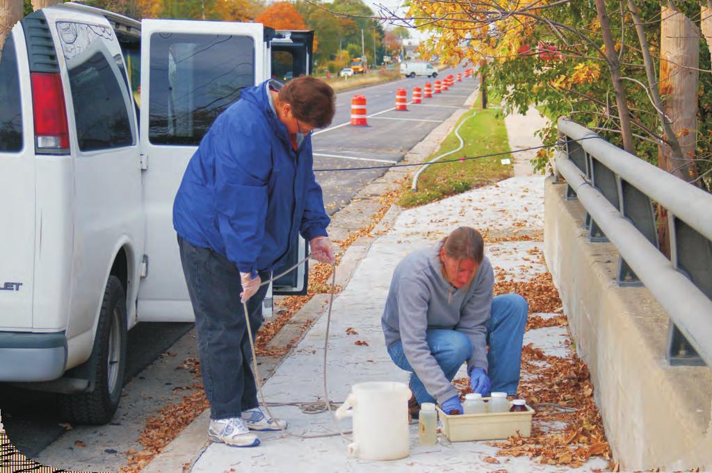
2 MILWAUKEE METROPOLITAN SEWERAGE DISTRICT (MMSD) SURFACE WATER QUALITY MONITORING PROGRAM DATA SUMMARY REPORT - SURVEY DESCRIPTIONS Overview The goal of the Milwaukee Metropolitan Sewerage District (MMSD) water quality monitoring program is to document long term beneficial water quality improvements as a direct result of the facilities and watercourse improvement projects, nonpoint pollution prevention programs, and stormwater management plans. The monitoring strategies developed by the District support and substantiate the District's goals and policies of improved water quality and environmental protection. In 1979 the District began its surface water quality-monitoring program to comply with the spirit of the Federal Water Pollution Control Act objectives and State water quality standards. Since the completion of the Inline Storage System (ISS) in 1993, the District has substantially reduced overflows helping to significantly improve Milwaukee-area water quality. Another component to the District's mission is to protect and manage the area's water resources through flood management planning/implementation. Both the reductions of CSO's and improvements made in managing floods are further justification to document long term, surface water quality trends within the District's service area. In order to afford the MMSD greater spatial coverage, the Water Quality Monitoring program includes thirteen different surveys. Three surveys monitor Lake Michigan conditions near our wastewater treatment plants (Outer Harbor and South Shore surveys) and background Lake conditions (Nearshore survey). The District also conducts ten other surveys to monitor the effects of our operations and improvements made to our facilities and from our flood management efforts. These surveys include Rivers (Milwaukee, Menomonee, and Kinnickinnic), Little Menomonee River, Root River, Lincoln, Oak, Southbranch, Indian, Fish, Underwood, and Honey Creeks. The information that follows lists additional details about this program, the rationale for monitoring area surface waters and the related laboratory variable names and detection limits used to assist with data interpretation. Data analysis for this report includes two parts, statistical summaries of the physical, chemical and biological analytical data from each monitoring site and box plots showing trends in the summarized data dating back to 19 where available. Due to the extent of box plot trend analysis for 15 sites and variables, it was decided to select some key indicator variables and show trends of select sites that would spatially represent the surveys. The box plots show a comparison of the median and percentile values for up to 1 years prior to the ISS completion, 1 years after ISS completion, the past three years () and the current year of analysis (). Results that are below the laboratory method detection limit are included as a zero value. Monitoring Seasonal Time Frame/Frequency Water quality monitoring of the local area rivers occurs year round. Winter sampling frequency is dependent on ice conditions on the waterways. As ice conditions recede more surveys are added to the schedule. The District's water quality monitoring program survey schedule is generally conducted on a biweekly basis. Due to sampling logistics and safety concerns, the Nearshore Lake survey is conducted four to seven times in a sampling season, approximately three weeks between collection dates. The biweekly monitoring program will address by random design both dry and wet weather-sampling periods. W/word/reports/Stat Report/Survey Descrip.doc 1/1/1ew 1
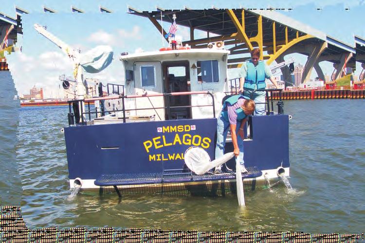
3 Monitoring Depth The District's routine water quality monitoring program provides for sampling the water column at various depths depending on the specific depth of a particular monitoring location. Exact sampling depths at any location may vary from year to year or week to week depending on lake levels, seiches, dam operation and precipitation. Generally, three samples are collected at sites greater than four meters in depth (one meter below the surface, one meter above the bottom, and mid-depth point). Locations less than four meters in depth are generally sampled at either two depths (one meter below the surface and one meter above the bottom) or one depth (mid-depth) depending on site conditions. Samples are collected from mid-channel or where the predominance of flow is occurring at each location. Samples for metals tests are collected at middepth at sites greater than four meters depth and at the surface for shallower monitoring sites. Monitoring Variables In all, there are types of water quality analyses listed in this data summary report. Each sample's tests may vary by survey type and depth due to method specifications, scientific judgement and costs. Where feasible the variables analyzed for each survey are kept consistent for data assessment purposes. Types of Surveys The District's surface water quality monitoring program is presently engaged in both Lake Michigan and River/Creek surveys including the following: Outer Harbor (East of Jones Island Water Reclamation Facility) Major Rivers (Milwaukee, Menomonee, Kinnickinnic Rivers) Fish Creek Southbranch Creek Indian Creek Lincoln Creek Underwood Creek Little Menomonee River Honey Creek South Shore (East of the South Shore Water Reclamation Facility) Oak Creek Root River Nearshore (Nearshore zone of Lake Michigan) The sampling rationale for the various monitoring surveys is briefly explained below. Outer Harbor Data collected from this area (Figure 1) on a biweekly basis are utilized to evaluate the impact that the Jones Island and river discharges are having on the quality of this part of the Lake that is intensively used for recreational boating and fishing. Sampling sites for this effort were selected based upon their position relative to the effluent outfall at Jones Island and the movement of water (or currents) found in the area. Samples are collected at 15 different locations. The point identified as OH- is the existing outfall for the Jones Island Water Reclamation Facility. As a point of reference the distance from Outer Harbor sampling point OH-7 to Outer Harbor sampling point OH-1 is one mile. W/word/reports/Stat Report/Survey Descrip.doc 1/1/1ew
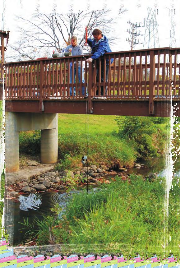
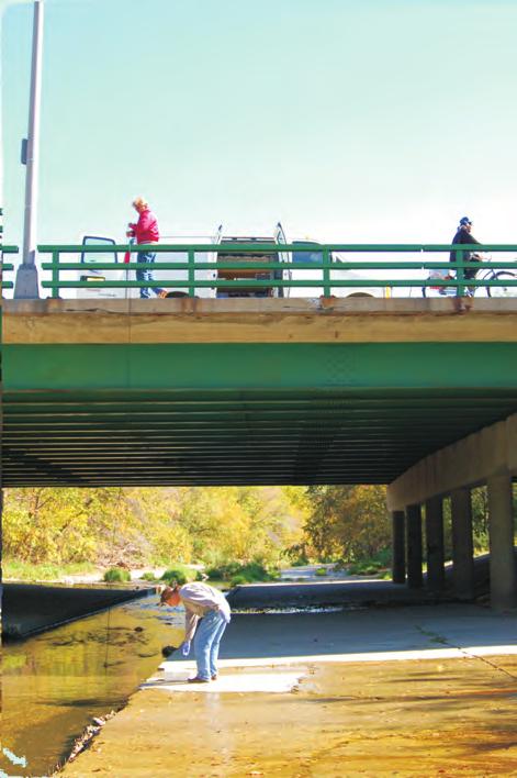
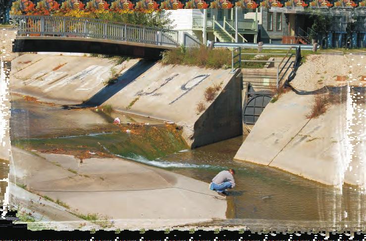
4 Rivers Extensive monitoring of the three major river systems (Figure ) within the District's sewer service boundaries provides baseline data for measuring and documenting potential sources of pollution both inside and outside the District boundaries. Water quality improvements as a direct result of facility and watercourse planning and systems operations can also be measured through the use of this survey's sampling results. There are sites that are routinely monitored for this survey (designated RI and a site number). There are several additional sites listed in Figure that have either been monitored in the past or are associated with specific event monitoring projects. Milwaukee River - The Milwaukee River is the largest river within the District's Service area and is currently recognized by community leaders as an important recreational water resource within the metropolitan area. This River enters the District at Pioneer Road (County Trunk C) from the north after passing through % of its drainage area. This monitoring effort was started in 19 to provide baseline data for the Water Pollution Abatement Plan (WPAP) and will enable the District to assess its positive effects on water quality over time. In addition, recent plans for flood management improvements by MMSD on tributaries to this river will also be evaluated by utilizing current and historical water quality monitoring databases. Menomonee and Kinnickinnic River Surveys - Basically these two rivers have all of their respective watersheds within the boundaries of the District's service area. Water Quality improvement may result through the control of Combined Sewer Overflows (CSO) discharges and by the elimination of various discharge points which represent relief bypasses. Significant improvements in water quality due to the WPAP may be noted in these two rivers. However, uncontrolled, nonpoint sources of pollution may continue to have impacts. Also, evaluation of current and future flood management improvements, as part of MMSD s Watercourse Management Plan, will rely heavily on water quality data for these waters. Data collected will be useful to evaluate all of these factors. Fish Creek The Menomonee River Valley has also been recently cited as having a promising potential for economic development. Continued water quality monitoring could help in planning that development. Fish Creek (Figure 3) is mainly located along the border between Milwaukee and Ozaukee counties in the Village of Bayside and the City of Mequon. The stream emerges from a storm sewer outfall at the south side of Donges Bay Road just west of Port Washington Road in the City of Mequon. Fish Creek drains directly into Lake Michigan 3.3 miles downstream from the source. Major precipitation events result in rapid surface runoff to Fish Creek, thereby causing a flashy response in this stream. This further results in significant flooding in the Village of Bayside. The District is in the process of evaluating options to reduce flooding as well as decreasing erosion along Fish Creek. This survey is conducted times per year (once a month, April - November) and has two sampling sites (FC- 1 and FC-). The Fish Creek survey was added to the District's monitoring program in in order to collect baseline data. If construction type improvements are chosen as a means to manage flooding problems in this watershed, then the water quality monitoring data will help in documenting and planning this process. Southbranch Creek This creek, (Figure ) approximately 1.5 miles long, drains a.95 square mile area within the Villages of Brown Deer, River Hills and the City of Milwaukee before it enters into the Milwaukee River. The entire watershed lies in an urban setting and drains by means of a storm sewer system. Southbranch Creek has a W/word/reports/Stat Report/Survey Descrip.doc 1/1/1ew 3
5 long history of flooding. Residential neighborhoods along the creek periodically flood during significant storms. In response to this recurring problem the MMSD along with other concerned parties have developed a flood management plan intended to minimize flooding. Highlights include the installation of four stormwater detention basins, the replacement of some culverts and deepening a section of the creek. Water quality monitoring in this watershed was added to the District s sampling program in 1999 to obtain data before, during and after the implementation of the flood management and environmental restoration project. This survey is conducted 1 times per year, once per month in the spring and autumn and twice per month during the summer of each year. The four sampling sites are designated with a "SB" and a site number. Indian Creek Indian Creek (Figure 5) is a major tributary of the Milwaukee River located in northern Milwaukee County. The creek,. miles in length, originates in the Village of Bayside near the intersection of East Brown Deer Road and North Rexleigh Drive. The Creek flows in a generally southwest direction through the Village of Fox Point, crosses Interstate 3 at the boundary of Fox Point and the Village of River Hills, and has its confluence with the Milwaukee River just south of Bradley Road in River Hills. Large storms typically cause flooding in this watershed. This survey is conducted eight times per year (once a month, April - November) and has four sampling sites (IC-1 through IC-). The Indian Creek survey was added to the District's monitoring program in prior to implementation of the MMSD watercourse management plan for this stream. Continued monitoring will assist in documenting changes in water quality due to the completion of this plan. Lincoln Creek This creek (Figure ) enters the Milwaukee River downstream Silver Spring Drive (RI-3) and is north of our Port Washington Road sampling site (R1-). Lincoln Creek is approximately nine miles in length and drains a 1-square mile watershed. There is a history of this creek having poor water quality and flooding problems due to urbanization within its watershed. In response to these problems the District along with other concerned parties have developed and implemented a flood management plan which involves environmental restoration, creation of wetland stormwater detention areas, changes in creek channel morphology, streambank erosion controls and improvement in creek bed substrate. Water quality monitoring in this watershed was added to the District s sampling program in 1997 to obtain data before, during and after the implementation of this plan. This survey is sampled once per month; April through November. The five sampling sites (designated LC and a site number) cover nearly 9% of the creek, from the headwaters to within a half mile of its confluence with the Milwaukee River. Underwood Creek Underwood Creek (Figure 7) originates in the City of Brookfield and flows approximately miles, in a southeasterly direction, to its confluence with the Menomonee River. The Underwood Creek subwatershed encompasses approximately 19. square miles and includes portions of the communities of Brookfield, Elm Grove and Wauwatosa. The Underwood Creek subwatershed is comprised of the Underwood Creek mainstem, Dousman Ditch, and the South Branch of Underwood Creek. The majority of Underwood Creek (UC) and the South Branch of UC are in a concrete lined channel. The South Branch of UC flows 1. miles in a northerly direction from its origin at West Greenfield Avenue to its confluence with Underwood Creek near West Bluemound Road. The South Branch of UC flows through the cities of Milwaukee, West Allis, Brookfield, and New Berlin. Flooding problems have occurred in the UC subwatershed and sections of this creek are undergoing flood management improvements. Underwood Creek was added to the MMSD sampling program in 3 and includes two sites on the South Branch of UC and five sites on the Underwood Creek mainstem. Surveys are scheduled once a month from W/word/reports/Stat Report/Survey Descrip.doc 1/1/1ew
6 April November. The monitoring plan is to collect data for several years prior to any stream improvement projects, during construction and for several years after construction is completed to compare and document water quality changes in this watershed. Little Menomonee River The Little Menomonee River (Figure ) originates in southern Ozaukee County near Freistadt Rd. and flows in a mostly southerly direction for a distance of approximately 1 miles to its confluence with the Menomonee River near Highway 1 and Hampton Avenue (Timmerman Field airport area). The Little Menomonee River subwatershed encompasses approximately 1. square miles, or nearly 1 percent of the Menomonee River watershed and includes portions of the communities of Mequon, Germantown and Milwaukee. It is entirely confined within the borders of Ozaukee and Milwaukee counties. The Little Menomonee River was added to the MMSD monitoring program in 7 and includes two sites (ML-1 and ML-). Surveys are scheduled to be sampled twice a month (March - December) and are completed concurrently with the Menomonee River survey. The monitoring plan is to collect data from this subwatershed in order to assess water quality impacts stemming from the Little Menomonee River. Honey Creek Honey Creek (Figure 9) originates at the S. 3rd Street storm sewer outfall in the City of Greenfield and flows in a northerly direction for approximately. miles until its confluence with the Menomonee River in the City of Wauwatosa. The Honey Creek subwatershed encompasses 11 square miles and includes portions of the communities of Greenfield, Milwaukee, Wauwatosa, and West Allis. Channel modifications such as deepening, straightening, and lining with concrete have been made to 7.1 miles of Honey Creek. The Creek flows under State Fair Park in an enclosed channel that consists of 3 1 foot by 15 foot pipes. The Honey Creek subwatershed has experienced minor flooding problems, but the biggest problem with this Creek has been the ecological degradation and habitat loss due to channel modifications. Honey Creek was added to the MMSD sampling program in 3 and includes five sampling sites (HC-1 - HC-5). This survey is conducted eight times per year (once a month, April - November). Baseline monitoring data is being collected to assist with future flood management planning efforts. South Shore Data collected from this area (Figure 1) on a biweekly basis is used to assess the impact of the discharge of the South Shore Water Reclamation Facility on the local environs of Lake Michigan. The point identified as SS-1 is the point of discharge from this facility. A major drinking water plant intake (Oak Creek) is located approximately one-mile southeast of SS-1. As with the Outer Harbor Survey, sample locations were based upon the Lake currents found in the area and relative position of a selected sampling site to the outfall. Samples are collected at three depths at each site in a scheme similar to the Outer Harbor effort. The distance from SS-1 to SS-3 is 1, feet; the distance from SS-1 to SS-11 is 3, feet. Oak Creek This stream (Figure 11) lies completely within the District boundaries. Oak Creek flows into Lake Michigan about two miles north of the MMSD s South Shore Water Reclamation Facility. Knowledge of its water quality is helpful in determining impacts to the Lake s nearshore area. When monitoring began for the Oak Creek survey in 195 the area was primarily rural drainage basin. Since then it has undergone significant development. Urbanization will increase the flows that the stream will be required to handle. The objective of the District is to monitor the resulting water quality changes over time. Oak Creek is a part of the District's W/word/reports/Stat Report/Survey Descrip.doc 1/1/1ew 5
7 facility and watercourse management planning initiatives. This survey is sampled once per month; April through November. There are seven sampling sites monitored for this survey and are designated with "OC" and a site number. Root River This river (Figure 1) drains approximately 197 square miles within Milwaukee, Waukesha, Racine and Kenosha counties. There is a history of low storm sewers within this river's watershed (potential for water back up) and flooding problems due to increasing urbanization within its watershed. In response to these problems, the District along with other concerned parties, are working on a flood management plan that may involve environmental restoration, creation of wetland stormwater detention areas, changes in creek channel morphology, streambank erosion controls and improvement in riverbed substrate. Water quality monitoring in this watershed was added to the District s sampling program to obtain data before, during and after the implementation of this plan. This survey is conducted 1 times per year, once per month in the spring and autumn and twice per month during the summer of each year. The six sampling sites (designated "RR" and a site number) cover the upper 7 square miles of the watershed located within the District's service area. Nearshore Lake Michigan The purpose of this effort is to provide a data base for the District to assess the impact of MMSD discharges as well as all other sources of pollution, including stormwater runoff, on overall nearshore water quality. The scope of this effort overlaps those efforts being undertaken in the Outer Harbor and at South Shore and is conducted on a monthly basis (weather dependent). Some of this survey's sites are located at a distance from shore to provide data for determining Lake background levels. Lake background information has been useful in developing some of the District's effluent limitations and permit discharge fees. Sites located a distance from shore and are not one of the sites that overlap our Outer Harbor or South Shore efforts have a reduced list of variables tested. This is due to historical results that show values less than the method detection limit or very low concentrations for that test and were consequently removed from the list of tests requested for Lab analysis. The 1 points (Figure 13) sampled during this survey cover the area of the nearshore environs of Lake Michigan from Fox Point on the north to Wind Point on the south and from the western shore of Lake Michigan to a point ten miles east of the western shore. Sample sites are designated as NS and a site number. The total area of lake covered by this survey is over 3 square miles. Data Usage The data generated by the District's surface water quality and other related environmental monitoring programs have been utilized extensively in-house as well as by other agencies and/or organizations and individual citizens. Also, this data has allowed other public agencies to make informed, defensible decisions regarding Milwaukee's valuable surface water resources. Examples of uses for this data include the MMSD Facilities Plan (developed by multi-agency and citizen stakeholder committees) and the Regional Water Quality Management Plan (required under the Clean Water Act) that has been recently updated by the Southeastern Wisconsin Regional Planning Commission. This type of long-term, comprehensive information has provided a service to the community by eliminating the need for smaller, more expensive piecemeal projects that would be required each time a specific need for information arises. The District's comprehensive and aggressive surface water quality monitoring program reflects the District's commitment to the improvement and preservation of the community's surface water resources and it should be continued for use in future water resource decisions for the Milwaukee metropolitan area. W/word/reports/Stat Report/Survey Descrip.doc 1/1/1ew
8 Abbreviations Legend for MMSD Water Quality Data Variable Abbr. & name ph TEMP - Temperature DO - Dissolved Oxygen CHLA - Chlorophyll a NITRATE - Nitrate Nitrogen NITRITE - Nitrite Nitrogen NO5 Nitrite + Nitrate Nitrogen AMMONIA - Ammonia Nitrogen TKN - Total Kjeldahl Nitrogen PHOS Phosphorus SOLPHOS - Soluble Phosphorus SOLSIL -Soluble Silica SCHII - Sechii Disk IXLITE - 1% Light Level (measured with a Photometer) TS - Total Solids DS - Dissolved Solids VSS - Volatile Suspended Solids SS - Suspended Solids TURB Turbidity SPEC - Specific Conductivity CHLOR Chloride FECAL - Fecal Coliform Bacteria LFC - Log 1 Fecal Coliform Bacteria ECOLIQT - Escherichia coli Bacteria CA - Total Calcium MG - Total Magnesium CD - Total Cadmium CR - Total Chromium CU - Total Copper NI - Total Nickel PB - Total Lead ZN - Total Zinc AG - Total Silver AS - Total Arsenic SE - Total Selenium HG - Mercury HARD Hardness TALK - Total Alkalinity BOD5/ - Biochemical Oxygen Demand 5 and day TC - Total Carbon TNIC - Total Nonpurgeable Inorganic Carbon TNOC - Total Nonpurgeable Organic Carbon TNDOC - Total Nonpurgeable Dissolved Organic Carbon Units of Measure Std. Units Degrees Celsius mg/l 3 mg/m mg/l mg/l mg/l mg/l mg/l mg/l mg/l mg/l meters meters mg/l mg/l mg/l mg/l NTU umhos/cm mg/l CFU/1 ml CFU/1 ml MPN/1 ml mg/l mg/l ug/l ug/l ug/l ug/l ug/l ug/l ug/l ug/l ug/l ug/l mg/l mg/l mg/l mg/l mg/l mg/l mg/l W:/ewaldmer/my documents/ms office/word/report files/statrptwqdata Abbrev_units9.docx 1/1/1ew
9 Water Quality Standards/Criteria for MMSD Water Quality Data Variable Standard/Criterion References Dissolved Oxygen Creeks/Rivers/Harbor 5 mg/l 1 Open Lake mg/l 1 Fecal Coliform Bacteria CFU/1 ml 1 Chloride 395 mg/l Chlorophyll a 5. mg/m 3 3* Total Phosphorus Open Lake.7 mg/l 1 Creeks/Upstream.75 mg/l 1 Menomonee and Kinnickinnic Rivers Downstream.1 mg/l 1 Menomonee and Kinnickinnic Rivers All Milwaukee River /Harbor References 1. Wisconsin Department of Natural Resources (WDNR), Wisconsin Administrative Code, NR 1, Register, November, 1, No WDNR, Wisconsin Administrative Code, NR 15, Chronic Toxicity Criteria, Register, February,, No United States Environmental Protection Agency (USEPA), December,. Ambient Water Quality Criteria Recommendations, Rivers and Streams in Nutrient Ecoregion VII: USEPA, Office of Water, EPA -B--1. * (These values are not standards or criterion, but are recommended criterion that are used in the box plot trend analyses for reference). W/word/reports/WQStds7.doc 1/1/1ew
10 Summary of Method Detection Limits (MDLs) for Water Quality Data Analyte (units) Source 1 - Ref er ence M ethod(s) MDL Alkalinity (mg/l as CaCO 3 ) mg/l (/1/9) mg/l Ammonia (mg/l as N) 1-5NH з G. mg/l (5-35.1) Arsenic (μg/l) 3-1 C.5 μg/l (/1/9) 3-1 C 3.5 ug/l Biochemical Oxygen Demand (BOD) 5 day (mg/l) 1-51 B mg/l day (mg/l) 1-51 B mg/l Cadmium (μg/l) Calcium (mg/l) 3-1 C 3-1 C 3-1 C 3-1 C.1 μg/l (/1/9).9 μg/l.7 mg/l (/1/9). mg/l Carbon (mg/l as C) Dissolved Organic Nonpurgeable C.3 mg/l (Prior to //9) C.35 mg/l Total Inorganic Nonpurgeable C.3 mg/l (Prior to //9) C.35 mg/l Total Organic Nonpurgeable C.3 mg/l (Prior to //9) C.35 mg/l Total C.3 mg/l (Prior to //9) C.35 mg/l Chloride (mg/l) 1-5 Cl E. mg/l (-35.) Chlorophyll a (mg/m 3 ) 1-1 H.11 mg/m 3 Chromium (μg/l) 3-1 C 7.5 μg/l (/1/9) 3-1 C 3. μg/l Copper (μg/l) 3-1 C 3-1 C 3.7 μg/l (/1/9) 3.9 μg/l E. coli (MPN/1 ml) 1-93 B 1/1 ml 1-93 B 1/1 ml (/1/9, /7/9, //9, /7/9, 9/1/9, 1//9, 1/9/9) C-1
11 Summary of Method Detection Limits (MDLs) for Water Quality Data Analyte (units) Source 1 - Ref er ence M ethod(s) MDL Fecal Coliform (CFU/1 ml) 1-9 D /1 ml (3/5/9, 5//9, /1/9, /3/9, 7/9/9, /11/9, //9, 9/1/9, 1//9) 1-9 D 3/1 ml 1-9 D 1/1 ml (/1/9, 3/9/9, /1/9, 5/1/9, 5/7/9, //9, /19/9, 7//9, /1/9, /17/9, //9, /7/9, 9/1/9, 9//9, 9//9, 1/1/9, 1//9, 1/7/9, 1/9/9, 11/1/9, 11/19/9, 1/9/9) Hardness (mg/l as CaCO 3 ) 3-1 C NA (calculated) Lead (μg/l) 3-1 C. μg/l (/1/9) 3-1 C 3. μg/l Magnesium (mg/l) 3-1 C.15 mg/l (/1/9) 3-1 C.3 mg/l Mercury (μg/l) (Total) 3-77 A.1 ug/l 3 Nickel (μg/l) 3-1 C 1. μg/l (/1/9) 3-1 C 3. μg/l Nitrate + Nitrite (mg/l as N) mg/l Nitrate (mg/l as N) mg/l Nitrite (mg/l as N) mg/l Total Kjeldahl Nitrogen (mg/l as N) mg/l Phosphorus (mg/l as P) mg/l (Prior to //9) Soluble mg/l Total mg/l (Prior to //9) mg/l PAH (μg/l) 3-7 C See PAH L ab Report 3 Selenium (μg/l) 3-1 C 9. ug/l (/1/9) 3-1 C 9.9 ug/l Silica (mg/l as SiO ) mg/l (Prior to //9) mg/l Silver (μg/l) 3-1 C 3-1 C. ug/l (/1/9).1 μg/l C-
12 Summary of Method Detection Limits (MDLs) for Water Quality Data Analyte (units) Source 1 - Ref er ence Method(s) MDL Solids (mg/l) Suspended 1-5 D 1 mg/l Volatile 1-5 E 1 mg/l Total 1-5 B 1 mg/l Dissolved 1-5 C 1 mg/l Turbidity (NTU) NTU Zinc (μg/l) 3-1 C 3-1 C 1. ug/l (/1/9) 13. ug/l Footnotes 1 See M ethod References on Page C-. The MDL value listed is based on a 1:1 dilution. For differences in analyte dilution values consult LIMS (Laboratory Information Management System) Results. 3 M DL for samples analyzed at Pace Analytical L aboratory (Green Bay). C-3
13 Summary of Method Detection Limits (MDLs) for Water Quality Data METHOD REFERENCES 1. Standard Methods for the Examination of Water and Wastewater, th ed., 199. American Public Health Association (APHA), th Street, NW, Washington, DC 5.. Methods of Chemical Analysis of Water and Wastes, USEPA, EMSL, Cincinnati, OH 5, March, 193 (EPA-/-79-). 3. Test Methods for Evaluating Solid Waste, 3 rd Edition. SW USEPA, SWER, Washington, DC.. Methods of Chemical Analysis of Water and Wastes, USEPA, EMSL, Cincinnati, OH 5, March, 197 (EPA-/-79-).. 5. Methods of Chemical Analysis of Water and Wastes, USEPA, EMSL, Cincinnati, OH 5, March, 1993 (EPA-/-79-). W:ewald/mydoc/msoff/word/reportfiles/MDL_.docx C-
14
15 MMSD Water Quality Monitoring Program Data Outer Harbor, Site OH-1 1 1, Dissolved Oxygen (mg/l) Fecal Coliform (counts/1 ml) 1, Chloride (mg/l) Specific Conductance (umhos/cm) Median 5%-75% 1%-9% ---- WQ Standard/Criterion
16 MMSD Water Quality Monitoring Program Data Outer Harbor, Site OH Ammonia (mg/l).... Chlorophyll (mg/m 3 ) Total Phosphorus (mg/l) Total Soluble Phosphorus (mg/l) Median 5%-75% 1%-9% ---- WQ Standard/Criterion
17 MMSD Water Quality Monitoring Program Data Outer Harbor, Site OH-1 1 Total Suspended Solids (mg/l) Total Organic Carbon (mg/l) Zinc (ug/l) Copper (ug/l) Median 5%-75% 1%-9%
18 OUTER HARBOR - SITE 1 WATER QUALITY DATA - VARIABLE PH TEMP DO CHLA NITRATE NITRITE NO5 AMMONIA TKN PHOS SOLPHOS SOLSIL units su C mg/l mg/m3 mg/l mg/l mg/l mg/l mg/l mg/l mg/l mg/l Mean Standard Error Median Mode Standard Deviation Sample Variance Kurtosis Skewness Range Minimum Maximum Count Confidence Level(95.%) VARIABLE SCHII IXLITE TS DS VSS SS TURB SPEC CHLOR FECAL LFC ECOLIQT units meters meters mg/l mg/l mg/l mg/l NTU umhos/cm mg/l CFU/1 ml CFU/1 ml MPN/1 ml Mean Standard Error Median Mode ND ND Standard Deviation Sample Variance Kurtosis Skewness Range Minimum Maximum Count Confidence Level(95.%) ND = No Data Provisional MMSD Water Quality Data
19 OUTER HARBOR - SITE 1 WATER QUALITY DATA - VARIABLE CA MG CD CR CU NI PB ZN AG AS SE HG units mg/l mg/l ug/l ug/l ug/l ug/l ug/l ug/l ug/l ug/l ug/l ug/l Mean ND Standard Error ND Median ND Mode ND Standard Deviation ND Sample Variance ND Kurtosis ND ND 3.3 ND ND Skewness.5.9 ND ND 1.3 ND 5.. ND Range Minimum Maximum Count Confidence Level(95.%) ND VARIABLE HARD TALK BOD5 BOD TC TNIC TNOC TNDOC units mg/l mg/l mg/l mg/l mg/l mg/l mg/l mg/l Mean 5 15 ND ND ND Standard Error 7 ND ND ND Median 15 ND ND ND Mode 17 1 ND ND ND Standard Deviation 1 ND ND ND Sample Variance ND ND ND Kurtosis -1-1 ND ND ND Skewness ND ND...9 ND Range Minimum Maximum Count Confidence Level(95.%) 13 1 ND ND ND ND = No Data Provisional MMSD Water Quality Data
20 MMSD Water Quality Monitoring Program Data Outer Harbor, Site OH- 1 1, Dissolved Oxygen (mg/l) 199- Fecal Coliform (counts/1 ml) 1, Chloride (mg/l) Specific Conductance (umhos/cm) Median 5%-75% 1%-9% ---- WQ Standard/Criterion
21 MMSD Water Quality Monitoring Program Data Outer Harbor, Site OH Ammonia (mg/l) Chlorophyll (mg/m 3 ) Total Phosphorus (mg/l) Total Soluble Phosphorus (mg/l) Median 5%-75% 1%-9% ---- WQ Standard/Criterion
22 MMSD Water Quality Monitoring Program Data Outer Harbor, Site OH- 1 1 Total Suspended Solids (mg/l) Total Organic Carbon (mg/l) Zinc (ug/l) Copper (ug/l) Median 5%-75% 1%-9%
23 OUTER HARBOR - SITE WATER QUALITY DATA - VARIABLE PH TEMP DO CHLA NITRATE NITRITE NO5 AMMONIA TKN PHOS SOLPHOS SOLSIL units su C mg/l mg/m3 mg/l mg/l mg/l mg/l mg/l mg/l mg/l mg/l Mean Standard Error Median Mode Standard Deviation Sample Variance Kurtosis Skewness Range Minimum Maximum Count Confidence Level(95.%) VARIABLE SCHII IXLITE TS DS VSS SS TURB SPEC CHLOR FECAL LFC ECOLIQT units meters meters mg/l mg/l mg/l mg/l NTU umhos/cm mg/l CFU/1 ml CFU/1 ml MPN/1 ml Mean Standard Error Median Mode ND Standard Deviation Sample Variance Kurtosis Skewness Range Minimum Maximum Count Confidence Level(95.%) ND = No Data Provisional MMSD Water Quality Data
24 OUTER HARBOR - SITE WATER QUALITY DATA - VARIABLE CA MG CD CR CU NI PB ZN AG AS SE HG units mg/l mg/l ug/l ug/l ug/l ug/l ug/l ug/l ug/l ug/l ug/l ug/l Mean ND Standard Error ND Median ND Mode ND Standard Deviation ND Sample Variance ND Kurtosis ND ND -1. ND Skewness ND ND. ND Range Minimum Maximum Count Confidence Level(95.%) ND VARIABLE HARD TALK BOD5 BOD TC TNIC TNOC TNDOC units mg/l mg/l mg/l mg/l mg/l mg/l mg/l mg/l Mean 19 1 ND ND ND Standard Error 5 ND ND ND Median 15 ND ND ND Mode 15 ND ND ND Standard Deviation 3 7 ND ND ND Sample Variance ND ND ND Kurtosis ND ND.7.3. ND Skewness -1 ND ND..5.7 ND Range Minimum Maximum Count Confidence Level(95.%) 1 ND ND ND ND = No Data Provisional MMSD Water Quality Data
25 OUTER HARBOR - SITE 3 WATER QUALITY DATA - VARIABLE PH TEMP DO CHLA NITRATE NITRITE NO5 AMMONIA TKN PHOS SOLPHOS SOLSIL units su C mg/l mg/m3 mg/l mg/l mg/l mg/l mg/l mg/l mg/l mg/l Mean Standard Error Median Mode Standard Deviation Sample Variance Kurtosis Skewness Range Minimum Maximum Count Confidence Level(95.%) VARIABLE SCHII IXLITE TS DS VSS SS TURB SPEC CHLOR FECAL LFC ECOLIQT units meters meters mg/l mg/l mg/l mg/l NTU umhos/cm mg/l CFU/1 ml CFU/1 ml MPN/1 ml Mean Standard Error Median Mode ND. ND ND Standard Deviation Sample Variance Kurtosis Skewness Range Minimum Maximum Count Confidence Level(95.%) ND = No Data Provisional MMSD Water Quality Data
26 OUTER HARBOR - SITE 3 WATER QUALITY DATA - VARIABLE CA MG CD CR CU NI PB ZN AG AS SE HG units mg/l mg/l ug/l ug/l ug/l ug/l ug/l ug/l ug/l ug/l ug/l ug/l Mean Standard Error Median Mode Standard Deviation Sample Variance Kurtosis. 1.5 ND ND ND Skewness ND ND ND Range Minimum Maximum Count Confidence Level(95.%) VARIABLE HARD TALK BOD5 BOD TC TNIC TNOC TNDOC units mg/l mg/l mg/l mg/l mg/l mg/l mg/l mg/l Mean ND Standard Error ND Median ND Mode ND Standard Deviation ND Sample Variance ND Kurtosis ND Skewness ND Range Minimum Maximum Count Confidence Level(95.%) ND ND = No Data Provisional MMSD Water Quality Data
27 OUTER HARBOR - SITE WATER QUALITY DATA - VARIABLE PH TEMP DO CHLA NITRATE NITRITE NO5 AMMONIA TKN PHOS SOLPHOS SOLSIL units su C mg/l mg/m3 mg/l mg/l mg/l mg/l mg/l mg/l mg/l mg/l Mean Standard Error Median Mode Standard Deviation Sample Variance Kurtosis Skewness Range Minimum Maximum Count Confidence Level(95.%) VARIABLE SCHII IXLITE TS DS VSS SS TURB SPEC CHLOR FECAL LFC ECOLIQT units meters meters mg/l mg/l mg/l mg/l NTU umhos/cm mg/l CFU/1 ml CFU/1 ml MPN/1 ml Mean Standard Error Median Mode ND ND Standard Deviation Sample Variance Kurtosis Skewness Range Minimum Maximum Count Confidence Level(95.%) ND = No Data Provisional MMSD Water Quality Data
28 OUTER HARBOR - SITE WATER QUALITY DATA - VARIABLE CA MG CD CR CU NI PB ZN AG AS SE HG units mg/l mg/l ug/l ug/l ug/l ug/l ug/l ug/l ug/l ug/l ug/l ug/l Mean Standard Error Median Mode Standard Deviation Sample Variance Kurtosis ND ND.7 ND ND Skewness ND ND.7 ND.9.5 ND Range Minimum Maximum Count Confidence Level(95.%) VARIABLE HARD TALK BOD5 BOD TC TNIC TNOC TNDOC units mg/l mg/l mg/l mg/l mg/l mg/l mg/l mg/l Mean ND ND Standard Error 5 3. ND 1... ND Median 1 1. ND ND Mode 1 1. ND ND Standard Deviation 1.1 ND ND Sample Variance ND ND Kurtosis 3. ND ND Skewness. ND..1.1 ND Range Minimum Maximum Count Confidence Level(95.%) ND ND ND = No Data Provisional MMSD Water Quality Data
29 MMSD Water Quality Monitoring Program Data Outer Harbor, Site OH-5 1 1, Dissolved Oxygen (mg/l) Fecal Coliform (counts/1 ml) Chloride (mg/l) Specific Conductance (umhos/cm) Median 5%-75% 1%-9% ---- WQ Standard/Criterion
30 MMSD Water Quality Monitoring Program Data Outer Harbor, Site OH Ammonia (mg/l)..3. Chlorophyll (mg/m 3 ) Total Phosphorus (mg/l) Total Soluble Phosphorus (mg/l) Median 5%-75% 1%-9% ---- WQ Standard/Criterion
31 MMSD Water Quality Monitoring Program Data Outer Harbor, Site OH-5 Total Suspended Solids (mg/l) Total Organic Carbon (mg/l) Zinc (ug/l) Copper (ug/l) Median 5%-75% 1%-9%
32 OUTER HARBOR - SITE 5 WATER QUALITY DATA - VARIABLE PH TEMP DO CHLA NITRATE NITRITE NO5 AMMONIA TKN PHOS SOLPHOS SOLSIL units su C mg/l mg/m3 mg/l mg/l mg/l mg/l mg/l mg/l mg/l mg/l Mean Standard Error Median Mode Standard Deviation Sample Variance Kurtosis Skewness Range Minimum Maximum Count Confidence Level(95.%) VARIABLE SCHII IXLITE TS DS VSS SS TURB SPEC CHLOR FECAL LFC ECOLIQT units meters meters mg/l mg/l mg/l mg/l NTU umhos/cm mg/l CFU/1 ml CFU/1 ml MPN/1 ml Mean ND Standard Error ND Median ND Mode. ND 1. ND ND Standard Deviation ND Sample Variance ND Kurtosis ND Skewness ND Range Minimum Maximum Count Confidence Level(95.%) ND ND = No Data Provisional MMSD Water Quality Data
33 OUTER HARBOR - SITE 5 WATER QUALITY DATA - VARIABLE CA MG CD CR CU NI PB ZN AG AS SE HG units mg/l mg/l ug/l ug/l ug/l ug/l ug/l ug/l ug/l ug/l ug/l ug/l Mean ND Standard Error ND Median ND Mode ND Standard Deviation ND Sample Variance ND Kurtosis 5.9. ND ND 5. ND ND Skewness.1. ND ND. ND 3.9. ND Range Minimum Maximum Count Confidence Level(95.%) ND VARIABLE HARD TALK BOD5 BOD TC TNIC TNOC TNDOC units mg/l mg/l mg/l mg/l mg/l mg/l mg/l mg/l Mean 1 11 ND ND ND Standard Error 3 ND ND.9.7. ND Median 1 11 ND ND 9... ND Mode 1 11 ND ND ND Standard Deviation 19 ND ND ND Sample Variance ND ND ND Kurtosis 9 ND ND ND Skewness 3 ND ND ND Range Minimum Maximum Count Confidence Level(95.%) 13 ND ND ND ND = No Data Provisional MMSD Water Quality Data
34 OUTER HARBOR - SITE WATER QUALITY DATA - VARIABLE PH TEMP DO CHLA NITRATE NITRITE NO5 AMMONIA TKN PHOS SOLPHOS SOLSIL units su C mg/l mg/m3 mg/l mg/l mg/l mg/l mg/l mg/l mg/l mg/l Mean ND Standard Error..7. ND Median ND Mode ND Standard Deviation ND Sample Variance ND Kurtosis ND Skewness ND Range Minimum Maximum Count Confidence Level(95.%) ND VARIABLE SCHII IXLITE TS DS VSS SS TURB SPEC CHLOR FECAL LFC ECOLIQT units meters meters mg/l mg/l mg/l mg/l NTU umhos/cm mg/l CFU/1 ml CFU/1 ml MPN/1 ml Mean ND Standard Error ND Median ND Mode ND ND Standard Deviation ND Sample Variance ND Kurtosis ND Skewness ND Range Minimum Maximum Count Confidence Level(95.%) ND ND = No Data Provisional MMSD Water Quality Data
35 OUTER HARBOR - SITE WATER QUALITY DATA - VARIABLE CA MG CD CR CU NI PB ZN AG AS SE HG units mg/l mg/l ug/l ug/l ug/l ug/l ug/l ug/l ug/l ug/l ug/l ug/l Mean ND Standard Error ND Median ND Mode ND Standard Deviation ND Sample Variance ND Kurtosis ND ND -.7 ND ND -. ND Skewness ND ND.3 ND ND.1 ND Range Minimum Maximum Count Confidence Level(95.%) ND VARIABLE HARD TALK BOD5 BOD TC TNIC TNOC TNDOC units mg/l mg/l mg/l mg/l mg/l mg/l mg/l mg/l Mean ND ND ND Standard Error 1 ND ND...1 ND Median ND ND ND Mode 1 11 ND ND ND Standard Deviation 7 7 ND ND ND Sample Variance 53 3 ND ND ND Kurtosis -1 ND ND ND Skewness -1 1 ND ND ND Range Minimum Maximum Count 1 Confidence Level(95.%) ND ND.5..1 ND ND = No Data Provisional MMSD Water Quality Data
36 MMSD Water Quality Monitoring Program Data Outer Harbor, Site OH-7 1 1, Dissolved Oxygen (mg/l) Fecal Coliform (counts/1 ml) 1, Chloride (mg/l) Specific Conductance (umhos/cm) Median 5%-75% 1%-9% ---- WQ Standard/Criterion
37 MMSD Water Quality Monitoring Program Data Outer Harbor, Site OH Ammonia (mg/l) Chlorophyll (mg/m 3 ) Total Phosphorus (mg/l) Total Soluble Phosphorus (mg/l) Median 5%-75% 1%-9% ---- WQ Standard/Criterion
38 MMSD Water Quality Monitoring Program Data Outer Harbor, Site OH Total Suspended Solids (mg/l) Total Organic Carbon (mg/l) Zinc (ug/l) Copper (ug/l) Median 5%-75% 1%-9%
39 OUTER HARBOR - SITE 7 WATER QUALITY DATA - VARIABLE PH TEMP DO CHLA NITRATE NITRITE NO5 AMMONIA TKN PHOS SOLPHOS SOLSIL units su C mg/l mg/m3 mg/l mg/l mg/l mg/l mg/l mg/l mg/l mg/l Mean Standard Error Median Mode Standard Deviation Sample Variance Kurtosis Skewness Range Minimum Maximum Count Confidence Level(95.%) VARIABLE SCHII IXLITE TS DS VSS SS TURB SPEC CHLOR FECAL LFC ECOLIQT units meters meters mg/l mg/l mg/l mg/l NTU umhos/cm mg/l CFU/1 ml CFU/1 ml MPN/1 ml Mean Standard Error Median Mode ND Standard Deviation Sample Variance Kurtosis Skewness Range Minimum Maximum Count Confidence Level(95.%) ND = No Data Provisional MMSD Water Quality Data
40 OUTER HARBOR - SITE 7 WATER QUALITY DATA - VARIABLE CA MG CD CR CU NI PB ZN AG AS SE HG units mg/l mg/l ug/l ug/l ug/l ug/l ug/l ug/l ug/l ug/l ug/l ug/l Mean ND Standard Error ND Median ND Mode ND Standard Deviation ND Sample Variance ND Kurtosis ND ND -. ND ND Skewness 1.9. ND ND. ND 3.. ND Range Minimum Maximum Count Confidence Level(95.%) ND VARIABLE HARD TALK BOD5 BOD TC TNIC TNOC TNDOC units mg/l mg/l mg/l mg/l mg/l mg/l mg/l mg/l Mean ND Standard Error ND Median ND Mode ND Standard Deviation ND Sample Variance ND Kurtosis 3 5 ND ND Skewness ND...3. ND Range Minimum Maximum Count Confidence Level(95.%) ND ND = No Data Provisional MMSD Water Quality Data
41 OUTER HARBOR - SITE WATER QUALITY DATA - VARIABLE PH TEMP DO CHLA NITRATE NITRITE NO5 AMMONIA TKN PHOS SOLPHOS SOLSIL units su C mg/l mg/m3 mg/l mg/l mg/l mg/l mg/l mg/l mg/l mg/l Mean ND Standard Error..7. ND Median ND Mode ND Standard Deviation ND Sample Variance ND Kurtosis ND Skewness ND Range Minimum Maximum Count Confidence Level(95.%) ND VARIABLE SCHII IXLITE TS DS VSS SS TURB SPEC CHLOR FECAL LFC ECOLIQT units meters meters mg/l mg/l mg/l mg/l NTU umhos/cm mg/l CFU/1 ml CFU/1 ml MPN/1 ml Mean ND Standard Error ND Median ND Mode ND ND Standard Deviation ND Sample Variance ND Kurtosis ND Skewness ND Range Minimum Maximum Count Confidence Level(95.%) ND ND = No Data Provisional MMSD Water Quality Data
Water Quality Monitoring Data Summary Statistics 2011 Compiled by the Water Quality Research Department Milwaukee Metropolitan Sewerage District
 mmsdm Preserving The Environment Improving Water Quality Water Quality Monitoring Data Summary Statistics Compiled by the Water Quality Research Department Milwaukee Metropolitan Sewerage District 11/9/
Water Quality Monitoring Data Summary Statistics 2012
 Water Quality Monitoring Data Summary Statistics 212 Compiled by the Water Quality Research Department Milwaukee Metropolitan Sewerage District 11//213 13-1 MILWAUKEE METROPOLITAN SEWERAGE DISTRICT (MMSD)
2016 Surface Water Quality Annual Summary Report
 2016 Surface Water Quality Annual Summary Report Freshwater Resources Monitoring Department Background The Federal Water Pollution Control Act of 1948, through amendments and revisions, became known as
Background. Introduction
 Background The Federal Water Pollution Control Act of 1965, through amendments and revisions, became known as the Clean Water Act of 1977. This act mandates that all states have an Environmental Protection
Warm Mineral Springs Sampling by Sarasota County
 Warm Mineral Springs Sampling by Sarasota County John Ryan, Kathryn Meaux, Rene Janneman and Jon S. Perry Sarasota County Environmental Services Sarasota, Florida September 11 Warm Mineral Springs is a
Globeville Landing Outfall Surface Water. December 12, 2017 Andrew Ross, Jon Novick Denver Department of Public Health & Environment
 Globeville Landing Outfall Surface Water December 12, 2017 Andrew Ross, Jon Novick Denver Department of Public Health & Environment Introductions Andrew Ross Environmental Program Manager, DDPHE Jon Novick
Community Assistance Planning Report No. 330 A RESTORATION PLAN FOR THE OAK CREEK WATERSHED. Chapter 1 INTRODUCTION
 #239219 CAPR-330 (Oak Creek Watershed) Chapter 1 - Text 300-4010 MGH/LKH/JEB/mid 8/28/18, 9/6/18, 9/10/18 Community Assistance Planning Report No. 330 A RESTORATION PLAN FOR THE OAK CREEK WATERSHED Chapter
Table of Contents. Chapter 1: Introduction Facilities Plan Facilities Plan Report
 Table of Contents Chapter 1: Introduction... 1-1 1.1 Purpose... 1-1 1.2 Description and Responsibilities of Milwaukee Metropolitan Sewerage District... 1-1 1.3 History of Facilities Planning... 1-3 1.3.1
Henderson Watershed WRIA 13. Chapter Includes: Tanglewilde Stormwater Outfall Woodard Creek Woodland Creek
 Henderson Watershed WRIA 13 Chapter Includes: Tanglewilde Stormwater Outfall Woodard Creek Woodland Creek 146 Tanglewilde Stormwater Outfall PART OF HENDERSON WATERSHED PRIMARY LAND USES: Urban residential
Executive Summary EXECUTIVE SUMMARY. ES.1 Monitoring Program Objectives. ES.2 Summary of Monitoring Results
 EXECUTIVE SUMMARY ES.1 Monitoring Program Objectives The following are the major monitoring program objectives, as outlined in the Municipal Stormwater Permit: Assess compliance with the Municipal Stormwater
Bacon Creek Watershed Plan Implementation Chapter 3: Learning More - Monitoring to Secure New Data Draft
 Bacon Creek Watershed Plan Implementation Chapter 3: Learning More - Monitoring to Secure New Data Draft There are two main goals of watershed planning: protect good water quality and improve poor water
2006 WATER MONITORING REPORT
 26 WATER MONITORING REPORT May 27 Prepared for: South Washington Watershed District Prepared by: Memorandum To: Matt Moore South Washington Watershed District Administrator From: Wendy Griffin, Travis
Chapter 2: Technology/Indicator Analysis
 2020 Facilities Plan State of the Art Report Chapter 2: Technology/Indicator Analysis 2.1 Introduction To begin the production theory analysis, specific water quality indicators and technologies that address
4.0 SAN GABRIEL RIVER WATERSHED MANAGEMENT AREA
 4.0 SAN GABRIEL RIVER WATERSHED MANAGEMENT AREA 4.1 Watershed Description 4.1.1 Watershed Land Use, Percent Impervious, and Population Land use in the San Gabriel River Watershed Management Area is approximately
BASELINE ASSESSMENT OF WATER QUALITY IN SUPPORT OF THE ROOT RIVER WATERSHED RESTORATION PLAN
 BASELINE ASSESSMENT OF WATER QUALITY IN SUPPORT OF THE ROOT RIVER WATERSHED RESTORATION PLAN Preliminary Data Report August 3, 2011 August 1, 2012 Sarah Wright, BA Julie Kinzelman, PhD, MT (ASCP) September
SAN BERNARD RIVER ABOVE TIDAL - SEGMENT 1302
 SAN BERNARD RIVER ABOVE TIDAL - SEGMENT 1302 SAN BERNARD RIVER ABOVE TIDAL - SEGMENT 1302 LAND COVER BACTERIA DISSOLVED OXYGEN NUTRIENTS Impairment Concern No Impairments or Concerns SAN BERNARD RIVER
EPA Primary. (mg/l as CaCO3) (mg/l as CaCO3)
 (mg/l as CaCO3)") NORTH TEXAS MUNICIPAL WATER DISTRICT - Wylie Water Analysis Jan-2018 Mineral Analysis Raw Treated Standards Residue on Evaporation 412 456 500 1000 Silica (SiO2) 3.63 3.41 Iron (Fe) 0.378 0.259 0.3 0.3
NORTH TEXAS MUNICIPAL WATER DISTRICT - Wylie Water Analysis Jan-2018 Mineral Analysis Raw Treated Standards Residue on Evaporation 412 456 500 1000 Silica (SiO2) 3.63 3.41 Iron (Fe) 0.378 0.259 0.3 0.3
Managing Water Where It Falls: Green Infrastructure in Milwaukee, Wisconsin
 Managing Water Where It Falls: Green Infrastructure in Milwaukee, Wisconsin Presented by: Kevin L. Shafer, Executive Director Milwaukee Metropolitan Sewerage District (MMSD) Hosted by the Association of
RECOMMENDED SCOPE OF ACCREDITATION (For Testing Laboratories) * Test Method / Standard against which tests are performed
 * Test Method / Standard against which tests are performed") Sl Product / Material of test 1 Wastewater Colour, true colour units, 2 Turbidity, NTU 3 Total dissolved solids mg/1, IS-3025 (Part 4) -1983 2005: 2120 /C IS-3025 (Part 10)-1984 2005: 2130/B IS-3025 (Part
Sl Product / Material of test 1 Wastewater Colour, true colour units, 2 Turbidity, NTU 3 Total dissolved solids mg/1, IS-3025 (Part 4) -1983 2005: 2120 /C IS-3025 (Part 10)-1984 2005: 2130/B IS-3025 (Part
Peach Creek Watershed
 SH 304 Peach Creek Watershed Bastrop Peach Cree FM 713 Caldwell Peach Creek, Sandy Fork Copperas Creek 1803C Peach Creek Fayette FM 1054 US 90 Waelder US IH US 90 FM 1680 IH 10 Dry Run Gonzales SH 97 Peach
2015 SOURCE REDUCTION EFFECTIVENESS ANALYSIS
 A review of the Milwaukee Metropolitan Sewerage District s progress with source reduction programs and pollutant trends in influent, effluent and biosolids products, since the approval of the District
SPECIFICATION NO.1197S Addendum No.4 Attachment D. Appendix L- Ground Water Quality Data and Revised Construction Groundwater Discharge Plan
 SPECIFICATION NO.1197S Addendum No.4 Attachment D Appendix L- Ground Water Quality Data and Revised Construction Groundwater Discharge Plan Page 1 of 2 Specification No. 1197S Addendum No. 4 ATTACHMENT
Grants Pass Water Quality Monitoring
 Grants Pass Water Quality Monitoring 2003-2005 Rogue Valley Council of Governments April 2005 Rogue Valley Council of Governments Natural Resources Department 155 North First Street Central Point, Oregon
QUESTIONNAIRE FOR GENERAL WTP REQUESTED DATA FOR THE WATER TREATMENT PLANT (WTP) - Application : groundwater (well pit); urban wastewater;
 - Application : groundwater (well pit); urban wastewater;") REQUESTED DATA FOR THE WATER TREATMENT PLANT (WTP) - Application : ENVIRONMENTAL DATA - Temperature min. : C - Temperature max. : C - Altitude (m.a.s.l) : m - Plant location (geographic area, seismic zone,
REQUESTED DATA FOR THE WATER TREATMENT PLANT (WTP) - Application : ENVIRONMENTAL DATA - Temperature min. : C - Temperature max. : C - Altitude (m.a.s.l) : m - Plant location (geographic area, seismic zone,
Ambient Water Quality Objectives For The Tributaries To Okanagan Lake Near Kelowna
 Water Quality Ambient Water Quality Objectives For The Tributaries To Okanagan Lake Near Kelowna Overview Report Water Management Branch Environment And Resource Division Ministry Of Environment, Lands
Presentation to the District of Central Saanich Hagan-Graham and Tetayut Water Quality Monitoring Programs
 Presentation to the District of Central Saanich Hagan-Graham and Tetayut Water Quality Monitoring Programs April 2 th, 217 Hagan-Graham Summary Modern WQ program undertaken at sites on Hagan-Graham Creeks:
by Keith Kennedy Manager of Environmental Programs North Central Texas Council of Governments
 by Keith Kennedy Manager of Environmental Programs North Central Texas Council of Governments What is NPDES? National Pollutant Discharge Elimination System USEPA outfall permitting program Storm water
Pebble Project Surface Water Quality Program Streams, Seeps, and Ponds
 Day1_1445_Surface Water Quality_PLP_McCay.mp3 Pebble Project Surface Water Quality Program Streams, Seeps, and Ponds Mark Stelljes SLR International February 1, 2012 Outline Stream Program Overview Results
Honey Creek. Bacteria Investigation Survey. July-August Technical Services Engineering & Planning Department Water Quality Research Department
 Honey Creek Bacteria Investigation Survey July-August 2006 Technical Services Engineering & Planning Department Water Quality Research Department Milwaukee Metropolitan Sewerage District CONTRIBUTING AUTHORS
Pamela Reitsma Environmental Scientist Narragansett Bay Commission
 Pamela Reitsma Environmental Scientist Narragansett Bay Commission Narragansett Bay Commission Narragansett Bay Commission (NBC) is a quasi-state agency which oversees the two largest WWTFs in Rhode Island:
Septic System Impacts on Stormwater and Impaired Waterbodies. December 8, 2016 Tim Denison, Johnson Engineering Marcy Frick, Tetra Tech
 Septic System Impacts on Stormwater and Impaired Waterbodies December 8, 2016 Tim Denison, Johnson Engineering Marcy Frick, Tetra Tech Presentation Overview Charlotte County: Many areas adjacent to impaired
Tsulquate River Community Watershed Water Quality Objectives Attainment Report
 Tsulquate River Community Watershed Water Quality Objectives Attainment Report Environmental Quality Section Environmental Protection Division West Coast Region 2013 Report Prepared by: Clayton Smith.
Totten Watershed WRIA 13. Chapter Includes: Kennedy Creek. Schneider Creek (Totten)
") Totten Watershed WRIA 13 Chapter Includes: Kennedy Creek Schneider Creek (Totten) 257 Kennedy Creek #0012 PART OF TOTTEN/LITTLE SKOOKUM WATERSHED LENGTH OF CREEK: 10 miles BASIN SIZE: 19 square miles STREAM
Totten Watershed WRIA 13 Chapter Includes: Kennedy Creek Schneider Creek (Totten) 257 Kennedy Creek #0012 PART OF TOTTEN/LITTLE SKOOKUM WATERSHED LENGTH OF CREEK: 10 miles BASIN SIZE: 19 square miles STREAM
Newcastle Creek Community Watershed Water Quality Objectives Attainment Report
 Newcastle Creek Community Watershed Water Quality Objectives Attainment Report Environmental Quality Section Environmental Protection Division West Coast Region 2013 Report Prepared by: Clayton Smith.
4.3 WATER RESOURCES ALTERNATIVE A PREFERRED CASINO-RESORT PROJECT SURFACE WATER
 4.3 WATER RESOURCES 4.3.1 ALTERNATIVE A PREFERRED CASINO-RESORT PROJECT SURFACE WATER This section discusses potential direct and indirect impacts associated with the development of Alternative A on surface
CLMP+ Report on Grass Lake (Anoka County) Lake ID# CLMP+ Data Summary
 Lake ID# CLMP+ Data Summary") CLMP+ Report on Grass Lake (Anoka County) Lake ID# 02-0113-00 2012-2013 CLMP+ Data Summary October 2014 Authors Shannon Martin, MPCA Editing and graphic design Public Information Office Staff The (MPCA)
CLMP+ Report on Grass Lake (Anoka County) Lake ID# 02-0113-00 2012-2013 CLMP+ Data Summary October 2014 Authors Shannon Martin, MPCA Editing and graphic design Public Information Office Staff The (MPCA)
Byllesby Reservoir Phosphorus TMDL Public Meeting & Open House May 13, 2013 Phillippo Scout Reservation
 Byllesby Reservoir Phosphorus TMDL Public Meeting & Open House May 13, 2013 Phillippo Scout Reservation Minnesota Pollution Control Agency Cannon River Watershed Partnership wq-iw9-10n Thank you for your
Village of McBride Annual Water System Report
 Village of McBride Annual Water System Report - 2016 June 2017 The Village of McBride Annual Water System Report - 2016 McBride Water System Annual Report for 2016 In 2016 the McBride water system supplied
Mitchell L. Griffin Jean Bossart CH2M HILL Gainesville, Florida
 NPDES STORMWATER DATA RESULTS FOR JACKSONVILLE, FLORIDA INTRODUCTION Mitchell L. Griffin Jean Bossart CH2M HILL Gainesville, Florida New storm water data were collected for the City of Jacksonville's National
RESEARCH AND DEVELOPMENT DEPARTMENT
 RESEARCH AND DEVELOPMENT DEPARTMENT REPORT NO. 06-48 WATER AND SEDIMENT QUALITY ALONG THE ILLINOIS WATERWAY FROM THE LOCKPORT LOCK TO THE PEORIA LOCK DURING 2005 September 2006 Metropolitan Water Reclamation
Annex 7.1 National Ambient Air Quality Standards for Nepal, 2003
 Annex 7.1 National Ambient Air Quality Standards for Nepal, 2003 Parameters Units Averaging Time TSP (Total Suspended Particulars) Concentration in Ambient Air, maximum Test method µg/m 3 Annual - 24-hours*
Monitoring Stormwater Best Management Practices: Why Is It Important and What To Monitor
 Monitoring Stormwater Best Management Practices: Why Is It Important and What To Monitor Scott D. Struck, Ph.D. US EPA, Urban Watershed Management Branch New Jersey Water Monitoring Workshop 4/20/2006
NORTH GRIFFIN REGIONAL DETENTION POND - WETLANDS FILTRATION FOR NON-POINT SOURCE POLLUTION CONTROL AND ABATEMENT
 NORTH GRIFFIN REGIONAL DETENTION POND - WETLANDS FILTRATION FOR NON-POINT SOURCE POLLUTION CONTROL AND ABATEMENT Richard A. Greuel l and Ronald A. Feldner2 AUTHORS: 'Principal and 2Project Engineer, Integrated
SEWRPC Regional Water Quality Management Plan
 SEWRPC Regional Water Quality Management Plan Update for the Greater Milwaukee Watersheds: Recommended Plan Presentation for Root Pike WIN Watershed VisioningSession November 10, 2009 Michael G. Hahn,
Poly Met Mining, Inc. NPDES Antidegradation Review - Preliminary MPCA Determination
 January 10, 2018 Poly Met Mining, Inc. NPDES Antidegradation Review - Preliminary MPCA Determination Antidegradation Procedures Overview Poly Met Mining, Inc. (PolyMet) submitted an NPDES/SDS application
Appendix D Monitoring Program
 Appendix D Monitoring Program [This page left intentionally blank.] Shingle Creek and West Mississippi Watershed Management Commissions Third Generation Watershed Management Plan Monitoring Program Minnesota
MRSWMP Dry Run/ First Flush Summary
 Monterey Bay Sanctuary Citizen Watershed Monitoring Network 299 Foam Street Monterey, CA 93940 Bus. (831) 647-4227 Fax (831) 647-4250 2009-2010 MRSWMP Dry Run/ First Flush Summary Prepared by: Lisa Emanuelson,
Chapter 1: Kinnickinnic River Watershed Restoration Plan Executive Summary
 Chapter 1: Watershed Restoration Plan Executive Summary 1.1 Introduction The primary purpose of this Watershed Restoration Plan (WRP) is to identify specific actions that can be implemented between 2010
Appendix C: Water Quality Data
 Appendix C: Water Quality Data Your Project #: 111257005 Site: TIM HORTONS SYLVIA LAKE NSD # 16300R Attention: DAVID WHETTER STANTEC CONSULTING LTD 603-386 BROADWAY AVENUE WINNIPEG, MB CANADA R3C
In the fall of 2008, Barr and PolyMet identified four sources of historical Colby Lake water quality data. Those sources are listed below:
 External Memorandum To: Dave Blaha, ERM From: Miguel Wong and Katie Wenigmann Project: 23/69 0862.00 006 001 c: Jim Scott, PolyMet; Stuart Arkley, MDNR; John Borovsky, Barr PolyMet has not been requested
CANADA BRITISH COLUMBIA WATER QUALITY MONITORING AGREEMENT
 CANADA BRITISH COLUMBIA WATER QUALITY MONITORING AGREEMENT WATER QUALITY ASSESSMENT OF Elk River AT SPARWOOD (2 5) Prepared by: L. G. Swain, P. Eng. B.C. Ministry of Environment Prepared for: B.C. Ministry
Des Moines River Water Quality Network
 Des Moines River Water Quality Network Monthly Report for December 2014 Donna S Lutz Assistant Scientist/Project Manager 394 Town Eng Bldg Iowa State University (515) 294-9720 dslutz@iastate.edu http://www.ccee.iastate.edu/dmrwqn
2018 Monitoring Strategy for the Des Plaines River Watershed. Purpose
 2018 Monitoring Strategy for the Des Plaines River Watershed Purpose This Monitoring Strategy for the Des Plaines River Watershed in Lake County Illinois was developed by the Monitoring Committee of the
5.0 LOS ANGELES RIVER WATERSHED MANAGEMENT AREA
 5.0 LOS ANGELES RIVER WATERSHED MANAGEMENT AREA 5.1 Watershed Description 5.1.1 Watershed Land Use, Percent Impervious, and Population The Los Angeles Watershed Management Area has more than half its area
Grand River Monitoring
 City of Grand Rapids Environmental Services Grand River Monitoring by Mike Lunn Environmental Services Department Manager Grand River Monitoring History 1968 Grand River Monitoring Network Since 1988 Data
2020 Facilities Plan State of the Art Report. Table of Contents. Chapter 1: Introduction Appendix 1A: Production Theory...
 Table of Contents Chapter 1: Introduction... 1-1 1.1 Background... 1-1 1.2 Objectives of the Production Theory Analysis... 1-5 Chapter 1 Figures 1-1 RWQMPU Study Area and MMSD 2020 Planning Boundary...
Red River Gorge Restoration and Watershed Plan Chapter 3: Learning More - Monitoring to Secure New Data Draft
 Red River Gorge Restoration and Watershed Plan Chapter 3: Learning More - Monitoring to Secure New Data Draft There are two main goals of watershed planning: protect good water quality and improve poor
Area. Kinnickinnic River 24.7 Menomonee River Milwaukee River Oak Creek 28.2 Root River Lake Michigan Direct 40.
 Area Watershed (square miles) Kinnickinnic River 24.7 Menomonee River 135.8 Milwaukee River 700.0 Oak Creek 28.2 Root River 197.6 Lake Michigan Direct 40.7 Drainage Area Total 1,127.0 Number of Counties
WHIPPANY RIVER WATER QUALITY TREND ANALYSIS STUDY
 WHIPPANY RIVER WATER QUALITY TREND ANALYSIS STUDY FINAL REPORT AUGUST 28, 2012 PREPARED FOR THE WHIPPANY RIVER WATERSHED ACTION COMMITTEE PROJECT OFFICER: GEORGE VAN ORDEN, PH.D. TOWNSHIP OF HANOVER HEALTH
Impacts of Rainfall Events on Water Quality in the Houston Metro Area
 Impacts of Rainfall Events on Water Quality in the Houston Metro Area Hanadi Rifai and Anuradha Desai Civil and Environmental Engineering University of Houston, Houston, TX Acknowledgments TCEQ EPA Houston
Vancouver Watershed Health Assessment. Burnt Bridge Creek Watershed
 Vancouver Watershed Health Assessment Burnt Bridge Creek Watershed Presentation Overview 1. Introduction 2. Study Context 3. Burnt Bridge Creek Monitoring Program and Trend Analysis 4. Watershed Health
Fountain Creek Watershed Water Quality Overview. Fountain Creek Watershed Citizen Advisory Committee June 12, 2015
 Fountain Creek Watershed Water Quality Overview Fountain Creek Watershed Citizen Advisory Committee June 12, 2015 Outline Fountain Creek Watershed Strategic Plan - 2009 Regulatory standards and classifications
US Army Corps of Engineers Detroit District
 US Army Corps of Engineers Detroit District SECTION 905(B) PRELIMINARY ANALYSIS OF FLOOD RISK MANAGEMENT and ENVIRONMENTAL RESTORATION PROJECTS WAUWATOSA, WISCONSIN and GREATER MILWAUKEE WATERSHEDS, WISCONSIN
2014 ASSINIBOINE RIVER MONITORING REPORT
 October 15, 2014 Temperature º C 9.7 9.6 9.6 9.6 9.7 9.7 10.1 10.2 10.1 Dissolved Oxygen mg/l 10.3 10.2 10.2 10.3 10.1 10.2 10.2 10.2 10.2 Conductivity ms/cm 1.262 1.235 1.253 1.307 1.315 1.307 1.322 1.32
City and County maintenance responsibilities within the Oak Creek channel,
 SEWRPC Staff Memorandum SCOPE OF WORK FOR OAK CREEK WATERSHED RESTORATION PLAN March 2, 2015 INTRODUCTION This memorandum is provided in response to a request from Milwaukee County, the City of South Milwaukee,
STORMWATER POLLUTANT ASSESSMENT AT THE CITY OF KISSIMMEE
 STORMWATER POLLUTANT ASSESSMENT AT THE CITY OF KISSIMMEE Eric Gurr and Fidelia Nnadi Department of Civil and Environmental Engineering University of Central Florida, Orlando, FL ABSTRACT Historically,
3B IMPAIRED WATERS AND TMDL APPROACH
 3B IMPAIRED WATERS AND TMDL APPROACH 1. ISSUE Impaired waters are those waters that do not meet state water-quality standards for one or more pollutants, thus they are impaired for their designated uses.
Table A7.1 - Data Quality Objectives for Field and Laboratory Measurements
 Table A7.1 - Data Quality Objectives for Field and Laboratory Measurements PARAMETER UNITS MATRIX METHOD STORET AWRL PRECISION of laboratory duplicates (RPD) Field Parameters at AWRLS of lab matrix spikes
Stormwater Runoff Water Quality Characteristics From Highways in Lake Tahoe, California
 California State University, Sacramento (CSUS) University of California, Davis (UCD) California Department of Transportation (Caltrans) Stormwater Runoff Water Quality Characteristics From Highways in
DOE/PPPO/ &D1 FBP-ER-PRO-WD-RPT-0001 Revision 3 April ENVIRONMENTAL NON-RADIOLOGICAL PROGRAM INFORMATION
 5. ENVIRONMENTAL NON-RADIOLOGICAL PROGRAM INFORMATION 5.1 SUMMARY Non-radiological environmental monitoring at PORTS includes air, water, sediment, and fish. Monitoring of non-radiological parameters is
SOURCE WATER MONITORING
 Monitoring and Protecting Our Water Sources SOURCE WATER MONITORING The Upper Cache la Poudre (UCLP) Watershed Collaborative Monitoring Program was established in 28 between the City of Fort Collins, the
CERTIFICATE OF ANALYSIS
 Your C.O.C. #: 32531001 Attention: Scott Churko Engineering and Operations Dpt PO Box 1390 Parksville, BC Canada V9P 2H3 CERTIFICATE OF ANALYSIS MAXXAM JOB #: B279455 Received: 2012/09/06, 09:15 Sample
Environmental Services
 215 Environmental Services River Water Quality Summary for the Twin Cities Metropolitan Area In 215, Metropolitan Council Environmental Services (MCES) river monitoring was conducted at six automated and
Acidity and Alkalinity:
 Evaluation of Pollution Sources to Lake Glenville Quarterly Report December 2018 Kimberlee K Hall, PhD Environmental Health Program, Western Carolina University Summary Chemical and microbial analysis
Water Quality Study In the Streams of Flint Creek and Flint River Watersheds For TMDL Development
 Water Quality Study In the Streams of Flint Creek and Flint River Watersheds For TMDL Development Idris Abdi Doctoral Dissertation Presentation Major Advisor: Dr. Teferi Tsegaye April 18, 2005 Alabama
El Dorado Hydroelectric Project FERC Project No Water Quality Monitoring Report
 El Dorado Hydroelectric Project FERC Project No. 184 21 Water Quality Monitoring Report EL DORADO IRRIGATION DISTRICT 289 Mosquito Road Placerville, CA 95667 March 211 1. Introduction The El Dorado Irrigation
Environmental Management System
 Environmental Management System Moreton Bay Research Station (MBRS) Water Management Program 1. Program Scope The Water Management Program incorporates all the water used throughout the Moreton Bay Research
2006 Aliceville Reservoir Report. Rivers and Reservoirs Monitoring Program
 2006 Aliceville Reservoir Report Rivers and Reservoirs Monitoring Program Field Operations Division Environmental Indicators Section Aquatic Assessment Unit May 2011 Rivers and Reservoirs Monitoring Program
Middle Santa Ana River Bacterial Indicator TMDL 2009 Dry Season Report
 Middle Santa Ana River Bacterial Indicator TMDL 2009 Dry Season Report December 31, 2009 on behalf of Santa Ana Watershed Project Authority San Bernardino County Stormwater Program County of Riverside
Concentration of Metals (Cd, Hg, Ag; mean +SD) in sediment samples collected from Pit Specific Sediment Chemistry Monitoring for CMP 1 in May 2014.
 in sediment samples collected from Pit Specific Sediment Chemistry Monitoring for CMP 1 in May 2014.") Figure 1: Concentration of Metals (Cr, Cu, Ni, Pb, Zn, As; mean +SD) in sediment samples collected from Pit Specific Sediment Chemistry Monitoring for CMP 1 in May 2014. Figure 2: Concentration of Metals
Figure 1: Concentration of Metals (Cr, Cu, Ni, Pb, Zn, As; mean +SD) in sediment samples collected from Pit Specific Sediment Chemistry Monitoring for CMP 1 in May 2014. Figure 2: Concentration of Metals
Chapter 3: Analytical Methods/Data Sources
 Chapter 3: Analytical Methods/Data Sources 3.1 Introduction A large amount of data was collected and analyzed to assess the existing and future conditions in the Milwaukee Metropolitan Sewerage District
Dyes Inlet DYES INLET WATERSHED Water Quality Monitoring Report Kitsap Public Health District
 DYES INLET WATERSHED 2014 Water Quality Monitoring Report Kitsap Public Health District 1 2 DYES INLET WATERSHED The Dyes Inlet watershed, designated as Primary Contact waters by the State, is located
Frequently Asked Questions for Permitting
 Frequently Asked Questions for Permitting What is a National Pretreatment Program? The National Pretreatment Program is a cooperative effort of federal, state, and local regulatory environmental agencies
Little Cypress Bayou Special Study - Subwatershed 1.10
 - Subwatershed 1.1 Sabine River Authority of Texas August 31, 21 Prepared in Cooperation with the Texas Natural Resource Conservation Commission Under the Authorization of the Texas Clean Rivers Act Table
Delaware River Basin Commission
 Delaware River Basin Commission Managing the Water Quality of a Shared Resource, the Delaware River Kenneth Najjar, Ph.D., P.E. Director, Water Resource Management June 28, 2018 South-East PA - Regional
Appendix D Surface Water and Groundwater Quality Standards
 Surface Water and Groundwater Quality Standards CLEAN WATER ACT The federal Clean Water Act (CWA) of 1972 and subsequent amendments require the identification and cleanup of polluted surface waters and
CARLYLE LAKE WATER QUALITY REPORT. for
 CARLYLE LAKE WATER QUALITY REPORT for 1997 U.S. ARMY CORPS OF ENGINEERS, ST. LOUIS DISTRICT ENVIRONMENTAL QUALITY SECTION - Water Quality Ted Postol, Section Chief Tori Foerste, Environmental Engineer
Maine Department of Environmental Protection Program Guidance on Combined Sewer Overflow Facility Plans
 Maine State Library Maine State Documents Land and Water Quality Documents Environmental Protection 9-1-1994 Maine Department of Environmental Protection Program Guidance on Combined Sewer Overflow Facility
REPORT ON RABBIT CREEK SPECIAL STUDY SUBWATERSHED 5.19
 REPORT ON RABBIT CREEK SPECIAL STUDY SUBWATERSHED 5.19 Sabine River Authority of Texas August 31, 23 Prepared in Cooperation with the Texas Commission on Environmental Quality Under the Authorization of
6. Pollutant Sources in
 6. Pollutant Sources in 45 6. Pollutant Sources in the Plum Creek Watershed The LDC analysis for Plum Creek indicates that both point and nonpoint sources contribute pollutants in the watershed. Identifying
Section F: Evaluating Beneficial Use: Recreation Ohio Integrated Report
 Section F: Evaluating Beneficial Use: Recreation 2008 Ohio Integrated Report F1. Background Prior to the 2002 IR, the reporting of recreational use impairment in Ohio was sporadic. Section 305(b) reports
Wood Canyon Emergent Wetland Project. City of Aliso Viejo 12 Journey, Suite 100 Aliso Viejo, CA 92656
 Wood Canyon Emergent Wetland Project City of Aliso Viejo 12 Journey, Suite 100 Aliso Viejo, CA 92656 Introduction Wood Canyon is located within Aliso and Wood Canyon Regional Park in southwest Orange County,
MARK TWAIN LAKE WATER QUALITY REPORT. for
 MARK TWAIN LAKE WATER QUALITY REPORT for 1997 U.S. ARMY CORPS OF ENGINEERS, ST. LOUIS DISTRICT ENVIRONMENTAL QUALITY SECTION - Water Quality Ted Postol, Section Chief Tori Foerste, Environmental Engineer
SCHEDULE I LIST I GENERAL STANDARDS AND CRITERIA FOR THE DISCHARGE OF INDUSTRIAL EFFLUENTS INTO INLAND SURFACE WATERS
 SCHEDULE I LIST I GENERAL STANDARDS AND CRITERIA FOR THE DISCHARGE OF INDUSTRIAL EFFLUENTS INTO INLAND SURFACE WATERS UNIT TOLERANCE LIMIT NO. PARAMETER TYPE OF LIMIT VALUES 01 Total suspended solids mg/1,
Sabine River Basin Volunteer Water Quality Monitoring Data Summary Report compiled by Texas Watch
 Sabine River Basin Volunteer Water Quality Monitoring Data Summary Report compiled by Texas Watch This data summary report includes general basin volunteer monitoring activity, general water quality descriptive
WATER QUALITY ASSESSMENT REPORT 2013 SAGINAW CHIPPEWA INDIAN TRIBE. Clean Water Act Section 106 October 1, 2012 September 31, 2013 Grant #: I 00E57603
 WATER QUALITY ASSESSMENT REPORT 2013 SAGINAW CHIPPEWA INDIAN TRIBE Clean Water Act Section 106 October 1, 2012 September 31, 2013 Grant #: I 00E57603 Technical Contacts: Carey Pauquette Water Quality Specialist
UPPER HOOD CANAL WATERSHED
 UPPER HOOD CANAL WATERSHED 2014 Water Quality Monitoring Report Kitsap Public Health District 1 2 UPPER HOOD CANAL WATERSHED The Upper Hood Canal (UHC) watershed, most of which is designated as Extraordinary
Subwatershed Prioritization of the Lake Wister Watershed Using Baseflow Water Quality Monitoring Data
 Subwatershed Prioritization of the Lake Wister Watershed Using Baseflow Water Quality Monitoring Data Bradley J. Austin, Brina Smith, and Brian E. Haggard Eutrophication Process by which excess nutrients
Appendix 2 Screening of Keewatinoow Construction Camp Waste Water Effluent Discharge to Creek Fourteen
 Appendix 2 Screening of Keewatinoow Construction Camp Waste Water Effluent Discharge to Creek Fourteen Prepared by: North/South Consultants Inc. July 19, 2011 Introduction The following provides a screening
LIBERTY BAY / MILLER BAY WATERSHED
 LIBERTY BAY / MILLER BAY WATERSHED 2014 Water Quality Monitoring Report Kitsap Public Health District 1 2 LIBERTY BAY / MILLER BAY WATERSHED The Liberty Bay / Miller Bay (LB/MB) watershed, designated as