MONITORING AND MODELING OF WATER QUALITY IN THE TIJUANA RIVER WATERSHED (Project WQ PP96II-10)
|
|
|
- Helena Jenkins
- 6 years ago
- Views:
Transcription
1 MONITORING AND MODELING OF WATER QUALITY IN THE TIJUANA RIVER WATERSHED (Project WQ PP96II-10) RICHARD M. GERSBERG C. BROWN SAN DIEGO STATE UNIVERSITY INTRODUCTION The Tijuana River Watershed (TRW) is a binational watershed on the westernmost portion of the US - Mexico border, encompassing much of the City of Tijuana in Mexico and portions of the City and County of San Diego in the US (Figure 1). The basin contains three surface water reservoirs, various flood control works, and a National Estuarine Sanctuary which is home to several endangered species and is protected by the US federal government. For decades, raw sewage from the city of Tijuana, Mexico has flowed into the Tijuana River and across the international border into the Tijuana Estuary. This problem has worsened in recent years with the substantial growth of Tijuana s population, along with intensive industrial development associated with the maquiladora (in-bond manufacturing and assembly plants) program in Mexico. Unfortunately, due to many factors, an industrial pretreatment program similar to one implemented in the United States, has not been initiated in Mexico. Moreover, in Mexico there is no program equivalent to the U.S. EPA s National Pollutant Discharge Elimination System (NPDES ) stormwater permitting program, so the threat of chemical contamination of the Tijuana Estuary is pronounced. Additionally, inadequate infrastructure for the collection, treatment, and disposal of sewage originating in Tijuana has long plagued the watershed, as wastewater flows have chronically outpaced the ability of the infrastructure to handle them. These elements yield transboundary and cross-cultural water quality management challenges. Although discharges from the Tijuana River account for only a small percentage of total gauged runoff to the Southern California coastal ocean, it contains the highest concentrations of suspended solids, Cd, Cu, Ni, Pb, Zn, and PCB,s among the eight largest creeks and rivers in Southern California (SCCWRP, 1992). Using flow weighted mean concentrations, SCCRWP (1992) estimated that the mass emission of metals from the Tijuana River for the year was 7,385 kg for Cr, 16,706 kg for Cu, 39,684 kg for Pb, 46,221 kg for Zn, and 205 kg for Cd. Obviously, significant loading of these toxic heavy metals to the Tijuana Estuary is occurring. To date, however, there has been no data published on the quality of urban stormwater in Mexico. 355
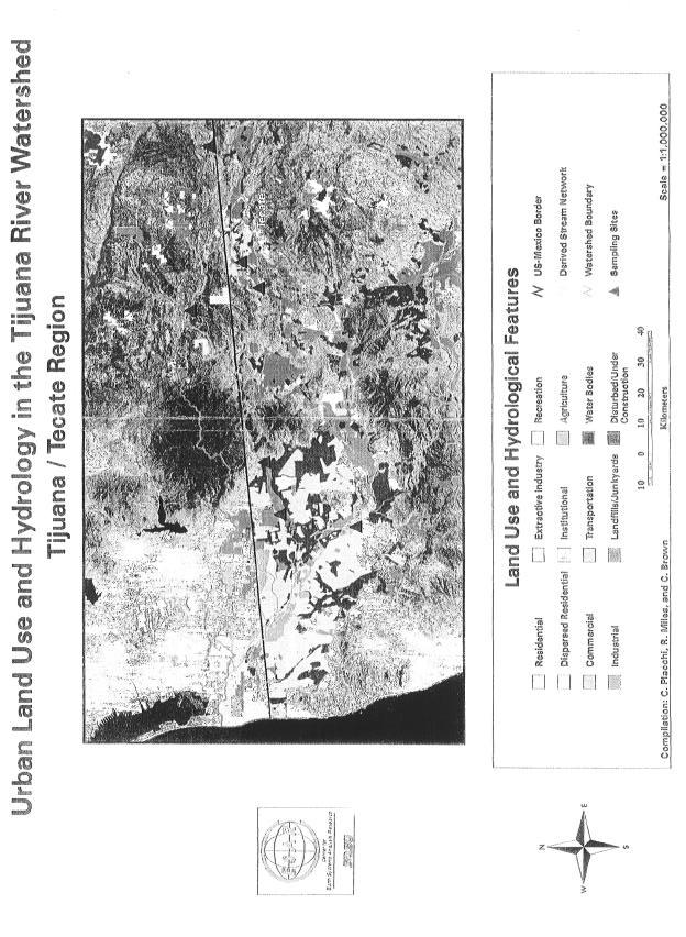
2 SCERP 1996 Final Report CX The purpose of this study was to determine the concentration of heavy metals and fecal indicator bacteria in stormwater associated with a variety of land uses in the Tijuana River Watershed. This research was the initial phase of a larger effort to use GIS-based modeling in a predictive fashion to estimate mass loading of stormwater pollutants to the Estuary under a variety of border development scenarios. METHODOLOGY Seven sites were sampled in the Tijuana River watershed; two in the US (Campo Creek and Cottonwood Creek), and the remaining sites in Mexico. The specific geographical coordinates for these sites were determined with a global positioning system (GPS) receiver, and were then incorporated into a geographical information system (GIS) for further analysis. The locations of these sites in the watershed are shown in Figure 2 and described below: Rural The Campo Creek in the US is just upstream of the city of Tecate, Mexico. This reach of the river runs through a relatively undeveloped and sparsely populated rural area of predominantly agricultural usage and flows into Tecate Creek, a main tributary of the Tijuana River. Urban This is a recently urbanized site in a canyon (Cañón del Zaines) that drains a fairly large residential area of southwestern Tijuana, then empties into the Rio de las Palmas branch of the Tijuana river. This site lies approximately 1 mile from the river and 3 miles downstream from La Presa Rodriquez, a reservoir from which Tijuana obtains part of its drinking water supply. Industrial This site lies at the foot of Otay Mesa, and drains a basin that contains one of the largest maquiladora park in Tijuana. Maquiladora plants are foreign-owned facilities that initially used lower priced Mexican labor to assemble goods from imported components, but presently the North American Free Trade Agreement (NAFTA) has allowed many of these plants to be full-scale production facilities. Cottonwood Creek This site is located directly under the State Highway 94 bridge that runs over the Cottonwood Creek branch of the river. It lies in a small sub-valley of the river that is mostly undeveloped, with limited agricultural activities, yet is proximal to a small mobile home park. We have selected this as a more representative site for our undeveloped sub-basin. 356
3 Monitoring and Modeling of Waste Water Quality Cañon del Padre Bridge This site also lies on this stem of the river, approximately 20 miles downstream from selected as an undeveloped site and to explore the hypothesis that the waste assimilative capacity of the upstream reach of the river may improve water quality at this site. Tecate and just above the eastern edge of the urban area of Tijuana. Considerable controversy exists as to whether water quality degradation on this reach of the river is caused by wastewater flows from Tijuana, Tecate, or both. By examining the assimilative capacity of the river, we will provide insight into this controversy. Schlage/Ingersoll Rand industrial site in Tecate This site sits on a very small arroyo that drains the Ingersoll Rand industrial complex in southwestern Tecate. Runoff in this arroyo flows directly from the site into the main channel of the Rio Tecate. The arroyo experiences intermittent and low flows except during heavy rain events when it flows freely; hence, this site yields stormwater runoff that is representative of wet weather industrial runoff. Tecate Creek Tecate Creek lies just below the urban area of Tecate, Mexico (a city of 90,000 inhabitants), and is a major tributary of the Tijuana River. Tecate has marginal sewage treatment and disposal infrastructure. This site is located approximately 1 mile downstream from the Tecate Municipal Wastewater Treatment Plant. CHEMICAL AND BIOLOGICAL ANALYSES Three storm events during the rainy season were sampled. Sampling dates were November 21-23, 1996, January 15-17, 1997, and March 10-12, Precipitation at La Presa Rodriguez reservoir (in the southern part of the city of Tijuana) was 12.0 mm, 11.4 mm, and <2.5 mm, respectively for the three storm events. The lack of measurable precipitation for the last event, does not imply that there was no rainfall in other parts of the watershed. Indeed, in this latter storm precipitation was observed (and runoff was sampled) at our sampling sites in the urban part of Tijuana and in the US portion of the watershed. Samples were taken as surface water grab samples twice during each storm event- once within the first 2-4 hours of the storm s inception (referred to as early -storm samples), and once again at an interval of hours after the first sample was taken (referred to as latestorm). During the March 10-12, 1997 rain event, late-storm runoff at the industrial and urban sites in Tijuana was very low and precluded sampling. All samples were handled, preserved, and analyzed according to Standard Methods (AWWA, APHA, WEF, 1989). Stormwater samples were filtered (for dissolved metal analysis), and the filter than digested for total metal analysis (total = particulate metal plus dissolved metal. Both particulate and dissolved metal concentrations were analyzed by graphite furnace 357
4 SCERP 1996 Final Report CX atomic absorption (GFAA) using a Perkin-Elmer SIMAA 6000 AA with Zeeman corrector. The exception was for the analysis of Zn, where flame atomic absorption spectrophotometry (Perkin-Elmer Model 2380) was used because of the relatively high levels of this metal. QA/QC for metals analysis included duplicate analyses, blanks, and standard additions to stormwater samples consisting of both dissolved metal spikes, and particulate metal spikes (in the form of a soil standard addition). Total coliform and fecal coliform bacteria were determined for stormwater samples using the Most Probable Number (MPN) procedure given in Standard Methods (AWWA, APHA, WEF, 1989). Enterococci was determined using a membrane filter ( MF) procedure using ME agar and EI (esculin iron) agar as per Standard Methods (AWWA, APHA, WEF, 1989). Nutrients in stormwater were analyzed by colorimetry, using the phenate method for ammonia, the cadmium reduction and diazotization method for nitrate, and the ascorbic acid method for phosphorus (Standard Methods, 1989). DETERMINATION OF LAND USE TYPES WITHIN EACH CONTRIBUTING SUB-BASIN To delineate which land use types were present within the sub-basins upstream from our points of sampling, we used modeling algorithms in our GIS software, a digital elevation model (DEM), and the locational data for the sampling sites to generate boundaries of the sub-basins. Specifically, we used the GRID module of the Arc/Info GIS to examine a DEM for the Tijuana River basin to model the direction and accumulation of surface water flows for each grid cell. The resulting flow direction and accumulation data formed the basis for a stream network map for the entire basin. We then placed each sampling point's location exactly on the stream network and ran a further series of algorithms that incorporated the accumulation data to generate the specific boundaries of the contributing sub-basins above each of the sample points. These sub-basin boundaries were then overlayed with land use data for the larger watershed to determine the composition of the land use within each sub-basin. RESULTS Table 1 shows the type and percentage of each land use type within each sub-basin sampled. The industrial site drains a rather small sub-basin (Otay Mesa) which is almost entirely developed (98.5%) with maqiladoras, these industrial facilities comprised mostly of assembly and manufacturing plants. The urban site is in the southern part of the City of Tijuana and drains a basin that is presently 63% undeveloped, but is subject to increasing urbanization as the city expands. The two major categories of developed land uses at this site are disturbed/ under construction and residential, comprising 14% and 11%, respectively of the total land area. The rural site at Campo Creek ( which drains into Tecate Creek) lies in the United States, just above the city of Tecate, Mexico,. This sub-basin is in a rural area, which is 88% 358
5 Monitoring and Modeling of Waste Water Quality non-developed. The two major land use categories are agriculture and dispersed residential, comprising 6.5% and 3.1%, respectively of the total land area. Tecate Creek site is a major tributary of the Tijuana River. It drains a very large sub-basin of 39,660 hectares, which is 81.5% non-developed. The two major land use categories are agriculture and residential, comprising 9.5% and 3.8%, respectively of the total land area of this sub-basin. It is important to underscore the fact that although this sub-basin is predominantly undeveloped, Tecate Creek receives the effluent discharge from both the city of Tecate Municipal Sewage Treatment Plant and the Tecate Brewery, both located just a few miles upstream of our sampling point. Figures 3-8 show the mean total metal levels for each metal analyzed for three storm events for each of four land use designations, including industrial, urban, rural, and the mixed-use subbasin of Tecate Creek. For the metals Cr, Cu, and Zn, the industrial land use showed the highest early-storm metal concentrations, with mean values of 102 ppb for Cd, 158 ppb for Cu, and 1,473 ppb for Zn. In the case of Pb, however, the urban land use showed the highest level, with a mean level of 372 ppb. Table 2 shows the percent of heavy metals associated with the filterable particulate fraction of the stormwater runoff for industrial, urban, and undeveloped (rural) landuses. It can be seen that the values for the particulate-associated fraction are rather high for all the metals at most of the sites. Indeed, for both early and late-storm samples, the values are greater than 50% for all the metals at the industrial and urban sites. Only at the rural site, do the percentage of particulate-associated metals fall below 50%, for Ni, Pb, and Zn. The high percentage of particulate-associated metals implies that strategies, which involve erosion control in the upper watershed, may reduce metal contamination of the downstream estuary. Figures 9-11 show the mean bacterial indicator levels (including total and fecal coliforms and enterococci) for the three storm events sampled for each land use category. Levels of the indicators at Tecate Creek were as high as those found in raw sewage in the U.S., with densities of MPN/100ml for TC and FC and MPN/100ml for enterococci. The next highest levels measured were for the urban land use site, but even the industrial site showed elevated densities as compared to the rural site on Campo Creek.. Figures show the level of the inorganic nutrients, ammonia-n, nitrate-n+ nitrite- N, and phosphate-p at the four sites for the early and late-storm events, respectively. Levels of ammonia-n are relatively low at all of the sites, but levels of nitrate-n+nitrite-n are elevated particularly for the early storm events at both the industrial and urban sites. For phosphate-p, the levels at all sites except the rural (mostly undeveloped) site are elevated. 359
6 SCERP 1996 Final Report CX DISCUSSION Metal concentrations in stormwaters of the Mexican portion of the Tijuana River watershed vary considerably, both during the course of a storm event, from event to event at a given site, and from site to site depending on land use (Figs. 3-8). Such variability is a result of variations in rainfall characteristics, differing watershed features that affect runoff quantity and quality, and variability in urban activities. Generally, the early storm metal concentrations for our sites in the Tijuana River watershed were higher than the late storm values, this pattern reflecting what is generally termed the first-flush phenomenon. A notable exception to this pattern was observed for Tecate Creek, where total levels of Cd, Cu, Cr, Ni in our late-storm samples were higher than for the early storm samples. For Ni, the site on Tecate Creek showed the highest value (226 ppb) among all of the sites. At this site, water quality standards for freshwaters promulgated by the U.S. EPA for toxic pollutants were exceeded for Cu, Pb (criterion continuous concentration only) and for Zn. The presence of elevated levels of these toxic heavy metals in Tecate Creek, a major tributary to the Tijuana River, is surprising due to the rather undeveloped nature of the watershed (Table 1), but is probably due to the point source discharge from the Municipal Treatment Plant of Tecate just upstream of our sampling point. This fact, coupled with our finding of rather continuous loading of metals (with no observable first-flush effect) at this site, suggests that Tecate Creek is a significant contributor to metal loading in the lower Tijuana River Watershed and Estuary. To the best of our knowledge, the present study represents the first time data has been published on the quality of stormwaters in the Mexican portion of the Tijuana River watershed. The U.S. EPA's National Urban Runoff Program (NURP)(U.S. EPA, 1992) identified toxic metals as the most prevalent priority pollutants found in urban runoff in the U.S.. The toxic metals lead, copper, and zinc were identified in 91% of the samples. Other inorganic pollutants detected were arsenic, chromium, cadmium, and nickel. (U.S. EPA, 1992). For the toxic heavy metals lead (Pb), zinc (Zn), and copper (Cu), the 90 th percentile concentrations were 465 ppb for lead, 540 ppb for Zn, and 120 ppb for Cu. While our storm event sampling was not entirely equivalent to the event mean concentrations ( EMC) given by the NURP data, they do provide a useful benchmark for comparison purposes. Using average values for our early-storm and late-storm events, total metal concentrations for the industrial land use site in the Tijuana watershed for Cu and Zn (128 ppb and 1353 ppb, respectively) exceeded both of the 90 th percentile NURP values, while the urban site exceeded the same NURP value for zinc only (620 ppb). To lend additional perspective to the data in an attempt to assess the degree to which the lack of an industrial pretreatment program in Mexico influences the quality of stormwaters, we can compare our data to that of Line et al. (1997) who measured the water quality of first flush runoff from 20 industrial sites in the U.S. These authors found mean levels of Pb, Zn, and 360
7 Monitoring and Modeling of Waste Water Quality Cu were 82 ppb, 593 ppb, and 116 ppb, respectively. The levels of these same metals in our early-storm runoff samples for our industrial land use site in Mexico fell in the 80 th percentile range of this U.S industrial runoff dataset Since the Tijuana River watershed is a semi-arid environment, it is useful to compare our results to those of similar coastal chaparral basins of southern California. A study on water quality under wet weather conditions at three sites in Ballona Creek (tributary to Santa Monica Bay) showed that the 90 percentile values for Pb, Zn and Cu were 1329 ppb, 2055 ppb, and 247 ppb, respectively (Stenstrom and Stecker, 1993). The fact that these values for an urban environment in coastal Los Angeles County generally exceeded those for our sites in the Tijuana River watershed, suggests that that stormwater contamination is ubiquitous in urban environments, even where industrial pretreatment and stormwater permitting regulations are in place. Our data clearly showed that the sparsely- developed, rural site (Campo Creek) showed relatively low levels of both heavy metals and bacterial indicators, and indicate that fecal contamination is not necessarily ubiquitous in the watershed, but is associated with development and human habitation. It is also of interest to note, that for these fecal indicators, no significant first-flush effect seems to exist, as the late- storm indicator densities are often as high or higher than are the early storm values (Figs. 9-11). This suggests a rather continuous contaminant loading source in these sub-basins (e.g sewer overflows and pump station failures). Gersberg et al. (1994) found that dry weather (baseline) flows in the Tijuana River were generally low and in the same range as indicator levels in dry weather runoff in southern California stormdrains. However, during wet weather, the densities of TC, FC in stormwaters of the Tijuana River generally exceeded the levels in surface runoff in an urban portion of the Santa Monica Bay watershed in southern California (Stenstrom and Stecker, 1993) by one to two orders of magnitude, this most probably due to the inadequate sewage collection infrastructure in the City of Tijuana CONCLUSIONS This study represents the first published data on the quality of stormwater in the Mexican portion of the Tijuana River watershed. Results show that levels of copper and zinc at both industrial and urban land use sites in the Tijuana watershed exceeded the 90 th percentile NURP values, but levels were not significantly elevated above those in urban wet weather flows in Los Angeles County. Our data document the effect of the discharge from the Tecate Municipal Treatment Plant on both metal and fecal indicator levels in Tecate Creek, and suggests that this major tributary to the Tijuana River is a significant source of pollutants to the watershed. 361
8 SCERP 1996 Final Report CX Nonpoint source pollution arising from a variety of land uses in the watershed will continue to contaminate the Tijuana Estuary and near-shore coastal ocean during wet weather, and therefore highlights the need for comprehensive wastewater and stormwater management in the urbanized portions of the watershed. CREDITS This study was funded by the Southwest Center for Environmental Research & Policy under Cooperative Agreement No. CX with the U.S. Environmental Protection Agency. The authors greatly appreciate the help of Paul Ganster, Richard Wright, and Walter Hayhow. REFERENCES APHA, AWWA, WEF (1989). Standard Methods for the Examination of Water and Wastewater, 17 th ed., Am. Public Health Assoc., Washington, D.C. EPA (1983) Results of the Nationwide Urban Runoff Program. PB , U.S. EPA, Water Planning Division, Washington, D.C. Gersberg, R.M., Dodge, D., Parsons, L., and Zedler, J.B. (1994) Microbiological water quality of the Tijuana Estuary. J. Border Health 10, Line, D.E., Wu, J., Arnold, J.A., Jennings, G.D., and Rubin, A.R. (1997) Water quality of first flush runoff from 20 industrial sites. Water Environ., Res 69, Southern California Coastal Water Research Project (1992) Surface Runoff to the Southern California Bight. Annual Report and Stenstrom, M.K., and Strecker, E.W. (1993) Assessment of Storm Drain Sources of Contaminants to Santa Monica Bay. Report to the Santa Monica Bay Restoration project, Monterey Park, CA. 362
9 Table 1- Area of major land uses and percent of total area (in parentheses) for each of the sub-basins sampled in the Tijuana River watershed. Site name and total basin area in Rural site Campo Creek ( ha) Industrial Site Otay Mesa (101.3 ha) Tecate Creek Site ( ha) hectares (ha) hectares industrial n/a 99.8 (98.5%) (0.38%) n/a Urban Site Cañon del Zaines ( ha) hectares commercial 5.6 (0.03%) n/a (0.38%) 10.9 (0.66%) hectares residential (3.1%).05 (0.05%) (3.8%) (11.3%) hectares agricultural (6.5%) n/a (9.5%) (9.2%) hectares nondeveloped (87.9%).04 (0.04%) (81.5%) (63%) hectares disturbed/under construction 29.6 (0.14%) 1.4 (1.4%) (2.2%) (14.2%) Table 2 Percent of total stormwater runoff of heavy metals associated with filterable particulates METAL INDUST. EARLY INDUST. LATE URBAN EARLY URBAN LATE RURALEARL Y RURAL LATE MEAN Cd Cr Cu Ni Pb Zn
10
11
12
13
14
15
16
17
Quality of Urban Runoffinthe Tijuana River Watershed
 IV Quality of Urban Runoffinthe Tijuana River Watershed Richard M. Gersberg, Chris Brown, V ctor Zambrano, Karilyn Worthington, and Daniel Weis ABSTRACT A sampling program was conducted to assess the quality
1.1 MONITORING PROGRAM OBJECTIVES The major objectives of the Monitoring Program outlined in the Municipal Stormwater Permit are to:
 1.1 MONITORING PROGRAM OBJECTIVES The major objectives of the Monitoring Program outlined in the Municipal Stormwater Permit are to: Assess compliance with the Los Angeles County Municipal Stormwater Permit
Executive Summary EXECUTIVE SUMMARY. ES.1 Monitoring Program Objectives. ES.2 Summary of Monitoring Results
 EXECUTIVE SUMMARY ES.1 Monitoring Program Objectives The following are the major monitoring program objectives, as outlined in the Municipal Stormwater Permit: Assess compliance with the Municipal Stormwater
Environmental Defense Section Telephone (202) P.O. Box 7611 Facsimile (202) Washington, DC 20044
 P.O. Box 7611 Facsimile (202) Washington, DC 20044") U.S. Department of Justice Environment and Natural Resources Division Environmental Defense Section Telephone (202) 514-2640 P.O. Box 7611 Facsimile (202) 514-8865 Washington, DC 20044 Sent Via e-mail
U.S. Department of Justice Environment and Natural Resources Division Environmental Defense Section Telephone (202) 514-2640 P.O. Box 7611 Facsimile (202) 514-8865 Washington, DC 20044 Sent Via e-mail
Dry-season water quality in the San Gabriel River Watershed
 Dry-season water quality in the San Gabriel River Watershed Drew Ackerman, Eric D. Stein and Kenneth C. Schiff ABSTRACT - Dry-season flow in the San Gabriel River system is comprised mostly of discharges
Dry-season Water Quality in the San Gabriel River Watershed
 Bulletin of the Southern California Academy of Sciences Volume 4 Issue 3 Article 2 2005 Dry-season Water Quality in the San Gabriel River Watershed Drew Ackerman Eric D. Stein Kenneth Schiff Follow this
5.0 LOS ANGELES RIVER WATERSHED MANAGEMENT AREA
 5.0 LOS ANGELES RIVER WATERSHED MANAGEMENT AREA 5.1 Watershed Description 5.1.1 Watershed Land Use, Percent Impervious, and Population The Los Angeles Watershed Management Area has more than half its area
SECTIONFOUR. Results and Interpretation 4.1 HYDROLOGY: PRECIPITATION AND FLOW
 1ONE SECTIONFOUR 4.1 HYDROLOGY: PRECIPITATION AND FLOW Over the past six years, Los Angeles County has experienced weather patterns that have resulted in very diverse storm seasons. The two most significant
Portland Water District Sebago Lake Watershed Monitoring Programs Tributary Monitoring ( ) Kirsten Ness
 Kirsten Ness") Introduction Portland Water District Sebago Lake Watershed Monitoring Programs Tributary Monitoring (1977 2016) Kirsten Ness Sebago Lake is the primary drinking water supply for nearly 200,000 people in
Introduction Portland Water District Sebago Lake Watershed Monitoring Programs Tributary Monitoring (1977 2016) Kirsten Ness Sebago Lake is the primary drinking water supply for nearly 200,000 people in
Newtown Creek Superfund Site Point Sources Sampling CAG Meeting March 22, 2016
 Newtown Creek Superfund Site Point Sources Sampling CAG Meeting March 22, 2016 CSTAG Meeting May 19-20, 2014 May 19, 2015 1 Objectives Define point source discharge for the study area Discuss the purpose
4.0 SAN GABRIEL RIVER WATERSHED MANAGEMENT AREA
 4.0 SAN GABRIEL RIVER WATERSHED MANAGEMENT AREA 4.1 Watershed Description 4.1.1 Watershed Land Use, Percent Impervious, and Population Land use in the San Gabriel River Watershed Management Area is approximately
Appendix F: Modeled Benefits for New Wet Weather Structural BMPs
 Appendix F: Modeled Benefits for New Wet Weather Structural BMPs APPENDIX F: MODELED BENEFITS FOR NEW WET WEATHER STRUCTURAL BMPS F.1 Introduction The purpose of this appendix is to document the methodology
Grants Pass Water Quality Monitoring
 Grants Pass Water Quality Monitoring 2003-2005 Rogue Valley Council of Governments April 2005 Rogue Valley Council of Governments Natural Resources Department 155 North First Street Central Point, Oregon
Ocean Water Quality Challenges
 Ocean Water Quality Challenges Dominic Gregorio Senior Environmental Scientist, Ocean Unit Division of Water Quality State Water Resources Control Board www.waterboards.ca.gov NPDES Permits written to
SECTIONTHREE. Methods 3.1 PRECIPITATION AND FLOW MEASUREMENT 3.2 STORMWATER SAMPLING Precipitation Monitoring. 3.1.
 1. Section 1 ONE This section describes the field and laboratory methods used to conduct the Monitoring Program, which includes precipitation and flow monitoring, stormwater sampling, laboratory analyses,
Background. Oso Watershed Land Uses
 Monitoring and Modeling of the Oso Creek and Oso Bay Watershed, Texas for a Bacteria TMDL Background Oso Creek and Oso Bay were identified as impaired segments in the 24 Texas Water Quality Inventory and
Final Report August 2005
 1.0 INTRODUCTION 1.1 Purpose of Report and Project Background National Pollutant Discharge Elimination System (NPDES) permitting requirements are mandated by the Federal Clean Water Act (CWA). In 1987,
Portland Water District Sebago Lake Watershed Monitoring Programs Crooked River Monitoring (1977 to 2016) Brie Holme
 Brie Holme") Portland Water District Sebago Lake Watershed Monitoring Programs Crooked River Monitoring (1977 to 2016) Brie Holme Introduction Sebago Lake is the primary drinking water supply for 200,000 people in
Portland Water District Sebago Lake Watershed Monitoring Programs Crooked River Monitoring (1977 to 2016) Brie Holme Introduction Sebago Lake is the primary drinking water supply for 200,000 people in
DOE/PPPO/ &D1 FBP-ER-PRO-WD-RPT-0001 Revision 3 April ENVIRONMENTAL NON-RADIOLOGICAL PROGRAM INFORMATION
 5. ENVIRONMENTAL NON-RADIOLOGICAL PROGRAM INFORMATION 5.1 SUMMARY Non-radiological environmental monitoring at PORTS includes air, water, sediment, and fish. Monitoring of non-radiological parameters is
Middle Santa Ana River Bacterial Indicator TMDL 2009 Dry Season Report
 Middle Santa Ana River Bacterial Indicator TMDL 2009 Dry Season Report December 31, 2009 on behalf of Santa Ana Watershed Project Authority San Bernardino County Stormwater Program County of Riverside
Portland Water District Sebago Lake Watershed Monitoring Programs Crooked River Monitoring (1977 to 2017) Brie Holme
 Brie Holme") Portland Water District Sebago Lake Watershed Monitoring Programs Crooked River Monitoring (1977 to 2017) Brie Holme Introduction Sebago Lake is the primary drinking water supply for 200,000 people in
Portland Water District Sebago Lake Watershed Monitoring Programs Crooked River Monitoring (1977 to 2017) Brie Holme Introduction Sebago Lake is the primary drinking water supply for 200,000 people in
Pamela Reitsma Environmental Scientist Narragansett Bay Commission
 Pamela Reitsma Environmental Scientist Narragansett Bay Commission Narragansett Bay Commission Narragansett Bay Commission (NBC) is a quasi-state agency which oversees the two largest WWTFs in Rhode Island:
MARYLAND DEPARTMENT OF THE ENVIRONMENT 1800 Washington Boulevard Baltimore MD
 MARYLAND DEPARTMENT OF THE ENVIRONMENT 1800 Washington Boulevard Baltimore MD 21230 410-537-3000 1-800-633-6101 Martin O Malley Governor Anthony G. Brown Lieutenant Governor November 6, 2009 Shari T. Wilson
Impacts of Rainfall Events on Water Quality in the Houston Metro Area
 Impacts of Rainfall Events on Water Quality in the Houston Metro Area Hanadi Rifai and Anuradha Desai Civil and Environmental Engineering University of Houston, Houston, TX Acknowledgments TCEQ EPA Houston
Rainbow Creek TMDL Monitoring Program Report for October 2016 through September 2017
 Rainbow Creek TMDL Monitoring Program Report for October 2016 through September 2017 Introduction The Rainbow Creek monitoring program has been developed to provide water quality data in support of the
Bacteria Study on the Tres Palacios River
 Bacteria Study on the Tres Palacios River Prepared by David Bass and Alicia Reinmund Lower Colorado River Authority Austin, Texas December 1999 For The Texas Clean Rivers Program Texas Natural Resource
Maine Department of Environmental Protection Program Guidance on Combined Sewer Overflow Facility Plans
 Maine State Library Maine State Documents Land and Water Quality Documents Environmental Protection 9-1-1994 Maine Department of Environmental Protection Program Guidance on Combined Sewer Overflow Facility
NEWPORT BAY FECAL COLIFORM TMDL
 NEWPORT BAY FECAL COLIFORM TMDL 2016 ANNUAL DATA REPORT SEPTEMBER 1, 2016 Prepared for: Santa Ana Regional Water Quality Control Board to fulfill requirements of the TMDL for Fecal Coliform in Newport
Dardenne Creek St. Charles County. May 2017 September Prepared for:
 Cooperative Stream Investigation Project Plan Missouri Department of Natural Resources Greenway Network, Inc. (Stream Team 463) and R.M. Wester and Associates, Inc. Dardenne Creek St. Charles County Prepared
THE EFFECTS OF EXTREMELY HIGH DENSITY SEPTIC SYSTEMS ON SURFACE WATER QUALITY IN GWINNETT COUNTY, GEORGIA
 THE EFFECTS OF EXTREMELY HIGH DENSITY SEPTIC SYSTEMS ON SURFACE WATER QUALITY IN GWINNETT COUNTY, GEORGIA John Anderson Georgia Perimeter College Lawrence Kiage Georgia State University Geographic Setting
Authors: Anna Lantin, RBF Consulting, Irvine, CA David Alderete Caltrans/CSUS Storm Water Program
 California State University, Sacramento (CSUS) University of California, Davis (UCD) California Department of Transportation (Caltrans) Effectiveness of Existing Highway Vegetation As Biofiltration Strips
APPENDIX F. Receiving Water Conditions, Potential Impacts of MS4 Discharges, and Priority Water Quality Conditions in the San Dieguito River WMA
 APPENDIX F Receiving Water Conditions, Impacts of MS4 Discharges, and Priority Water Quality Conditions in the San Dieguito River WMA Intentionally Left Blank Appendix F Receiving Water Conditions, Impacts
Quality of Highway Runoff at Two Locations in Amman City: A Preliminary Investigation
 2011 International Conference on Environment and BioScience IPCBEE vol.21 (2011) (2011) IACSIT Press, Singapore Quality of Highway Runoff at Two Locations in Amman City: A Preliminary Investigation Zain
Los Angeles County-Wide Structural BMP Prioritization Methodology
 Los Angeles County-Wide Structural BMP Prioritization Methodology A Guidance Manual for Strategic Storm Water Quality Project Planning Catchment Prioritization BMP Screening General BMP Evaluation Site-Specific
Table 2 Discharges for San Diego Creek
 Results of Heavy Metal Water Quality analysis Conducted During 2000 in the Upper Newport Bay Orange County, CA Watershed 1 Including Recommended Regulatory Approaches Prepared by G. Fred Lee, PhD, PE(TX),
Mitchell L. Griffin Jean Bossart CH2M HILL Gainesville, Florida
 NPDES STORMWATER DATA RESULTS FOR JACKSONVILLE, FLORIDA INTRODUCTION Mitchell L. Griffin Jean Bossart CH2M HILL Gainesville, Florida New storm water data were collected for the City of Jacksonville's National
Quality Assurance Project Plan. Sequim-Dungeness Watershed Water Pollutant Concentration Pilot Sampling Project
 Addendum Quality Assurance Project Plan Sequim-Dungeness Watershed Water Pollutant Concentration Pilot Sampling Project by Edward Chadd, Clallam County Department of Community Development Robert Knapp,
Southern California Bight 2008 Regional Monitoring Program: Volume VIII. Estuarine Eutrophication
 Technical Report 0711 Southern California Bight 2008 Regional Monitoring Program: Volume VIII. Estuarine Eutrophication K. McLaughlin 1, M. Sutula 1, L. Busse 2, S. Anderson 3, J. Crooks 4, R. Dagit 5,
Stormwater Data Characterization Results from Phase I Monitoring
 Stormwater Data Characterization Results from Phase I Monitoring 2007-2012 Brandi Lubliner, PE Co-authors: Will Hobbs, Nat Kale, Evan Newell Bellingham Bay Symposium, January 22, 2015 Stormwater Monitoring:
Capturing Storm Water in Semi-arid Climate
 Capturing Storm Water in Semi-arid Climate REBEKA SULTANA, PHD CALIFORNIA STATE UNIVERSITY, LONG BEACH NATHANIEL SUMMERVILLE, PE CALIFORNIA STATE UNIVERSITY LONG BEACH (STUDENT PROJECT MANAGER) AND CH2M
Monitoring Stormwater Best Management Practices: Why Is It Important and What To Monitor
 Monitoring Stormwater Best Management Practices: Why Is It Important and What To Monitor Scott D. Struck, Ph.D. US EPA, Urban Watershed Management Branch New Jersey Water Monitoring Workshop 4/20/2006
Newcastle Creek Community Watershed Water Quality Objectives Attainment Report
 Newcastle Creek Community Watershed Water Quality Objectives Attainment Report Environmental Quality Section Environmental Protection Division West Coast Region 2013 Report Prepared by: Clayton Smith.
City of Delray Beach MS4 Assessment Program: Part V. Monitoring Requirements MS4 Permit No. FLS
 City of Delray Beach MS4 Assessment Program: Part V. Monitoring Requirements MS4 Permit No. FLS 000018 004 The purpose of this document is to outline the assessment program for the City of Delray Beach
Bronx River Pollutant Loading Model Summary
 Bronx River Pollutant Loading Model Summary Section of River Located in Bronx County Table of Contents Drainage Areas...2 Data Sets Used for Analysis...2 Land Use Statistics...3 Model Calculations...3
GULF OF MEXICO - SEGMENT 2501
 GULF OF MEXICO - SEGMENT 2501 GULF OF MEXICO - SEGMENT 2501 LAND COVER BACTERIA CHLOROPHYLL A Impairment Concern No Impairments or Concerns GULF OF MEXICO - SEGMENT 2501 OTHER IMPAIRMENTS Bays & Estuaries
MS4 Assessment Program to Satisfy Part V. Monitoring Requirements
 MS4 Assessment Program to Satisfy Part V. Monitoring Requirements Submitted by City of Boynton Beach MS4 Permit No. FLS000018-004 The purpose of this document is to outline the City of Boynton Beach Stormwater
STORMWATER POLLUTANT ASSESSMENT AT THE CITY OF KISSIMMEE
 STORMWATER POLLUTANT ASSESSMENT AT THE CITY OF KISSIMMEE Eric Gurr and Fidelia Nnadi Department of Civil and Environmental Engineering University of Central Florida, Orlando, FL ABSTRACT Historically,
DRAFT ANNOTATED OUTLINE 12/4/2006
 DRAFT ANNOTATED OUTLINE 12/4/2006 INTEGRATED WATER MANAGEMENT PLAN SAN DIEGO REGION A. INTRODUCTION AND REGIONAL WATER MANAGEMENT GROUP Summary This Integrated Regional Water Management Plan (IRWM Plan)
Thames River Water Quality 2017
 Thames River Water Quality 2017 City Of London Environment and Engineering Services June 2018 Purpose: To present information on the water quality of the Thames River for 2017. Executive Summary Thames
FOR THE DOMINGUEZ CHANNEL WATERSHED MANAGEMENT AREA GROUP
 Enhanced Watershed Management Program FOR THE DOMINGUEZ CHANNEL WATERSHED MANAGEMENT AREA GROUP March 2015 Prepared by: Dominguez Channel Watershed Management Area Group City of Los Angeles County of Los
Lecture 7 Water Quality Monitoring: Estimation of fecal indicator bacteria
 Lecture 7 Water Quality Monitoring: Estimation of fecal indicator bacteria FECAL INDICATOR BACTERIA Fecal indicator bacteria, which are directly associated with fecal contamination, are used to detect
Vancouver Watershed Health Assessment. Burnt Bridge Creek Watershed
 Vancouver Watershed Health Assessment Burnt Bridge Creek Watershed Presentation Overview 1. Introduction 2. Study Context 3. Burnt Bridge Creek Monitoring Program and Trend Analysis 4. Watershed Health
Green Infrastructure Operation and Maintenance in the City of Los Angeles
 Green Infrastructure Operation and Maintenance in the City of Los Angeles stormwater runoff as a resource Adel Hagekhalil, PE, BCEE Wing K. Tam, P. E. Mike Antos October 21, 2013 City of Los Angeles Second
Water Quality Study In the Streams of Flint Creek and Flint River Watersheds For TMDL Development
 Water Quality Study In the Streams of Flint Creek and Flint River Watersheds For TMDL Development Idris Abdi Doctoral Dissertation Presentation Major Advisor: Dr. Teferi Tsegaye April 18, 2005 Alabama
Water Quality Assessment for the Town of Caswell Beach, 2008
 Water Quality Assessment for the Town of Caswell Beach, 2008 UNCW-CMS Report 08-02 Report to: Town of Caswell Beach 1100 Caswell Beach Rd. c/o Mr. Jim Carter, Town Administrator Caswell Beach, N.C. 28465
Chapter 2: Conditions in the Spring Lake Watershed related to Stormwater Pollution
 Chapter 2: Conditions in the Spring Lake Watershed related to Stormwater Pollution To identify the primary causes and consequences of stormwater discharges to Spring Lake and its adjoining waterbodies,
San Mateo/Cristianitos Creek Baseline Water Quality Monitoring Subproject Data Report. Orange County Coastkeeper. August
 San Mateo/Cristianitos Creek Baseline Water Quality Monitoring Subproject Data Report Orange County Coastkeeper August 25 2008 Table of Contents Page Project Map 3 Executive Summary 4 Background 6 Project
NEWPORT BAY FECAL COLIFORM TMDL
 NEWPORT BAY FECAL COLIFORM TMDL 2017 ANNUAL DATA REPORT SEPTEMBER 1, 2017 Prepared for: Santa Ana Regional Water Quality Control Board to fulfill requirements of the TMDL for Fecal Coliform in Newport
Stormwater. General Awareness Training
 Stormwater General Awareness Training Water Regulatory History 1972 Congress enacts Clean Water Act Regulates wastewater pollution 1987 Congress amends Clean Water Act Stormwater pollution regulation added
Regional Highway Stormwater Runoff Characteristics in California
 California State University, Sacramento (CSUS) University of California, Davis (UCD) California Department of Transportation (Caltrans) Regional Highway Stormwater Runoff Characteristics in California
MRSWMP Dry Run/ First Flush Summary
 Monterey Bay Sanctuary Citizen Watershed Monitoring Network 299 Foam Street Monterey, CA 93940 Bus. (831) 647-4227 Fax (831) 647-4250 2009-2010 MRSWMP Dry Run/ First Flush Summary Prepared by: Lisa Emanuelson,
Summary of Basin Characteristics and Facilities. General Land-use Characteristics: Withdrawal and Discharge Sites: Sampling Site Statistics:
 -Digit Watershed Identity Number: 28 This report was prepared by the Kentucky Water Research Institute as a product of the statewide Kentucky Watershed Management process. Information presented in this
Presentation to the District of Central Saanich Hagan-Graham and Tetayut Water Quality Monitoring Programs
 Presentation to the District of Central Saanich Hagan-Graham and Tetayut Water Quality Monitoring Programs April 2 th, 217 Hagan-Graham Summary Modern WQ program undertaken at sites on Hagan-Graham Creeks:
State of the San Lorenzo River Symposium Saturday, April 11, 2015 Greg Pepping, Executive Director Coastal Watershed Council
 State of the San Lorenzo River Symposium Saturday, April 11, 2015 Greg Pepping, Executive Director Coastal Watershed Council Coastal Watershed Council Santa Cruz-based 501(c)(3) Established 1995 Science-based
DC STORMWATER PLAN CONSOLIDATED TOTAL MAXIMUM DAILY LOAD (TDML) IMPLEMENTATION PLAN
 IMPLEMENTATION PLAN") DC STORMWATER PLAN CONSOLIDATED TOTAL MAXIMUM DAILY LOAD (TDML) IMPLEMENTATION PLAN CONTENTS Introduction 1 The Challenge 5 The Solution 7 Tracking Progress 11 What can you do? 15 INTRODUCTION The DC Stormwater
DC STORMWATER PLAN CONSOLIDATED TOTAL MAXIMUM DAILY LOAD (TDML) IMPLEMENTATION PLAN CONTENTS Introduction 1 The Challenge 5 The Solution 7 Tracking Progress 11 What can you do? 15 INTRODUCTION The DC Stormwater
TOWN LINE BROOK URBAN WATERSHED STUDY MODELING INCREMENTAL IMPROVEMENTS
 TOWN LINE BROOK URBAN WATERSHED STUDY MODELING INCREMENTAL IMPROVEMENTS Marcus M. Quigley, P.E., Project Engineer, GeoSyntec Consultants Steven P. Roy, Associate, GeoSyntec Consultants Lawrence Gil, North
IV. ENVIRONMENTAL IMPACT ANALYSIS G. HYDROLOGY/WATER QUALITY
 IV. ENVIRONMENTAL IMPACT ANALYSIS G. HYDROLOGY/WATER QUALITY ENVIRONMENTAL SETTING The project site is located in the Wilshire community of the City of Los Angeles and is bound by S. Wetherly Drive to
Grand River Monitoring
 City of Grand Rapids Environmental Services Grand River Monitoring by Mike Lunn Environmental Services Department Manager Grand River Monitoring History 1968 Grand River Monitoring Network Since 1988 Data
Re-plumbing Roadside Ditch Networks
 Re-plumbing Roadside Ditch Networks Ditches Improving management to reduce flooding, water pollution, and in-stream erosion and habitat degradation Rebecca Schneider Dept. Natural Resources Cornell University,
City of Daphne, Alabama Water Quality Monitoring Plan For Phase II MS4
 City of Daphne, Alabama Water Quality Monitoring Plan For Phase II MS4 2016-2021 Permit # ALR 040039, Expiration Date: September 30, 2021 I. Introduction This document presents the City of Daphne s Stormwater
ROUGE RIVER MONITORING FOR E. COLI TMDL IMPLEMENTATION FINAL REPORT GRANT#
 1 ROUGE RIVER MONITORING FOR E. COLI TMDL IMPLEMENTATION FINAL REPORT GRANT# 2011-0504 FUNDED BY: MICHIGAN DEPARTMENT OF ENVIRONMENTAL QUALITY CLEAN MICHIGAN INITIATIVE CLEAN WATER FUND LANSING, MI PREPARED
EXECUTIVE SUMMARY. Project Summary. Background
 EXECUTIVE SUMMARY Project Summary In 1998 one reach of Crow Creek was listed as impaired by the Wyoming Department of Environmental Quality (DEQ) and placed on the Clean Water Act (CWA), Section 303(d)
Acidity and Alkalinity:
 Evaluation of Pollution Sources to Lake Glenville Quarterly Report December 2018 Kimberlee K Hall, PhD Environmental Health Program, Western Carolina University Summary Chemical and microbial analysis
Wood Canyon Emergent Wetland Project. City of Aliso Viejo 12 Journey, Suite 100 Aliso Viejo, CA 92656
 Wood Canyon Emergent Wetland Project City of Aliso Viejo 12 Journey, Suite 100 Aliso Viejo, CA 92656 Introduction Wood Canyon is located within Aliso and Wood Canyon Regional Park in southwest Orange County,
3F. Hydrology and Water Quality
 This section provides an analysis of potential hydrological and water quality impacts associated with implementation of the proposed project. The section also evaluates and describes the potential impacts
Globeville Landing Outfall Surface Water. December 12, 2017 Andrew Ross, Jon Novick Denver Department of Public Health & Environment
 Globeville Landing Outfall Surface Water December 12, 2017 Andrew Ross, Jon Novick Denver Department of Public Health & Environment Introductions Andrew Ross Environmental Program Manager, DDPHE Jon Novick
SUSQUEHANNA RIVER MONITORING:
 SUSQUEHANNA RIVER MONITORING: Monitoring the fecal coliform bacteria and water quality in the Upper Susquehanna River, summer 2002 Selinda Schlierman 1 ABSTRACT As part of a long-term, ongoing study by
SAN BERNARD RIVER ABOVE TIDAL - SEGMENT 1302
 SAN BERNARD RIVER ABOVE TIDAL - SEGMENT 1302 SAN BERNARD RIVER ABOVE TIDAL - SEGMENT 1302 LAND COVER BACTERIA DISSOLVED OXYGEN NUTRIENTS Impairment Concern No Impairments or Concerns SAN BERNARD RIVER
Non-point Source Pollution Assessment of the San Antonio - Nueces Coastal Basin
 Non-point Source Pollution Assessment of the San Antonio - Nueces Coastal Basin By David R. Maidment and William K. Saunders Center for Research in Water Resources University of Texas Austin, TX 78712
Eight Characterizing Trends in the Barnegat Bay Watershed, Ocean County, New Jersey
 Eight Characterizing Trends in the Barnegat Bay Watershed, Ocean County, New Jersey Gail P. Carter New Jersey Department of Environmental Protection Division of Science and Research, CN049 Trenton, New
Water Quality in Athens- Clarke County
 Water Quality in Athens- Clarke County Mayor and Commission Work Session 1 December 8, 2015 Purpose Provide background on why the Unified Government of Athens-Clarke County (ACCUG) is involved with water
Draft Bacteria Total Maximum Daily Load Action Plan
 Draft Bacteria Total Maximum Daily Load Action Plan Public Works Department VSMP MS4 Permit # VA0088676 DRAFT June 12, 2018 Draft Bacteria Total Maximum Daily Load Action Plan (Permit VA0088676) Table
Johns Hopkins University. Master of Science in Environmental Science and Policy. Independent Graduate Project Proposal, Fall 2011
 Johns Hopkins University Master of Science in Environmental Science and Policy Independent Graduate Project Proposal, Fall 2011 Effects of Roadway Runoff on the Water Quality of the Codorus Creek Watershed
Parlee Beach Water Quality Summary
 Parlee Beach Water Quality Summary Introduction This document presents a summary of the report of the Steering Committee for the Parlee Beach Water Quality project. The Committee was comprised of representatives
Section 2 Stormwater Management Program Water Quality Assessment
 Section 2 Stormwater Management Program Water Quality Assessment 2.1 Stormwater Management Area Assessments Local Environmental Setting The, population 10,350 according to 2000 US census, generally lies
4.3 WATER RESOURCES ALTERNATIVE A PREFERRED CASINO-RESORT PROJECT SURFACE WATER
 4.3 WATER RESOURCES 4.3.1 ALTERNATIVE A PREFERRED CASINO-RESORT PROJECT SURFACE WATER This section discusses potential direct and indirect impacts associated with the development of Alternative A on surface
Alluvial Fans 150 Years of Flood Control, Urbanization, and Politics in Los Angeles
 Alluvial Fans 150 Years of Flood Control, Urbanization, and Politics in Los Angeles Los Angeles County Department of Public Works Topics to be Addressed Historic Perspectives Current Practices and Constraints
Setting Wasteload Allocations in a TMDL
 Setting Wasteload Allocations in a TMDL wq-strm7-84a Stormwater Module 4b Minnesota Pollution Control Agency Training Goals 1. Define wasteload allocation (WLA) 2. Understand the relationship between stormwater
LOXAHATCHEE RIVER WATER QUALITY EVENT SAMPLING TASK 2: FINAL REPORT ASSESSMENT OF LOXAHATCHEE RIVER WATER QUALITY
 LOXAHATCHEE RIVER WATER QUALITY EVENT SAMPLING TASK 2: FINAL REPORT ASSESSMENT OF 2007-2008 LOXAHATCHEE RIVER WATER QUALITY In Partial Fulfillment of Agreement No. 4600001281 For the Period October 2007
Marina del Rey Enhanced Watershed Management Program Plan
 Marina del Rey Enhanced Watershed Management Program Plan Prepared For: Marina del Rey Enhanced Watershed Management Program Agencies County of Los Angeles Los Angeles County Flood Control District City
Characteristics of Stormwater Runoff from Caltrans Facilities
 California State University, Sacramento (CSUS) University of California, Davis (UCD) California Department of Transportation (Caltrans) Characteristics of Stormwater Runoff from Caltrans Facilities Presented
Tsulquate River Community Watershed Water Quality Objectives Attainment Report
 Tsulquate River Community Watershed Water Quality Objectives Attainment Report Environmental Quality Section Environmental Protection Division West Coast Region 2013 Report Prepared by: Clayton Smith.
COASTAL CONSERVANCY. Staff Recommendation May 24, 2007 NORTH SAN DIEGO COUNTY COASTAL WATERSHEDS HYDROLOGIC MONITORING NETWORK
 COASTAL CONSERVANCY Staff Recommendation May 24, 2007 NORTH SAN DIEGO COUNTY COASTAL WATERSHEDS HYDROLOGIC MONITORING NETWORK File No. 07-030-1 Project Manager: Deborah Ruddock RECOMMENDED ACTION: Authorization
COASTAL POLLUTION STATUS AND THE NECESSITY OF URBAN RUNOFF POLLUTION CONTROLS IN HONG KONG
 Coasts at the Millennium Proceedings of the 17th International Conference of The Coastal Society, Portland, OR USA COASTAL POLLUTION STATUS AND THE NECESSITY OF URBAN RUNOFF POLLUTION CONTROLS IN HONG
A Hydrologic Study of the. Ryerson Creek Watershed
 A Hydrologic Study of the Ryerson Creek Watershed Dave Fongers Hydrologic Studies Unit Land and Water Management Division Michigan Department of Environmental Quality May 8, 2002 Table of Contents Summary...2
Best Management Practices for Stormwater Quality Treatment in Urban Settings. Lower Mississippi River WMO September 2017
 Best Management Practices for Stormwater Quality Treatment in Urban Settings Lower Mississippi River WMO September 2017 Stormwater 101 Impervious surfaces (pavement, parking lots, etc.): quickly produce
Sugar Creek Watershed Watershed Number:
 Watershed Watershed Number: 512511 Location Map Mercer Jessam ine %g 27 %g15 41 Harrodsburg Burgin %g 152 %g 39 %g1268 Sugar C reek W atershed Richm ond %g1355 %g 876 Madison %g 34 %g 595 Boyle Danville
OKLAHOMA DEPARTMENT OF ENVIRONMENTAL QUALITY PUBLIC NOTICE. January 24, 2008 AVAILABILITY OF DRAFT BACTERIA TMDL FOR THE NEOSHO RIVER BASIN
 Steve Thompson Executive Director OKLAHOMA DEPARTMENT OF ENVIRONMENTAL QUALITY Brad Henry Governor PUBLIC NOTICE January 24, 2008 AVAILABILITY OF DRAFT BACTERIA TMDL FOR THE NEOSHO RIVER BASIN REQUEST
CHAPTER 3 FLOOD RELATED STUDIES
 CHAPTER 3 FLOOD RELATED STUDIES Although the area has experienced regular flooding there have been few formal flood studies until more recently. There are a number of water quality studies in the basins.
MARK CREEK DEMONSTRATION PROJECT
 MARK CREEK DEMONSTRATION PROJECT OCC Tasks 20 and 21 FY 1990 319(h) Task 210 EPA Grant # C9-006704-90-0 Submitted by: Oklahoma Conservation Commission Water Quality Division 413 NW 12 th Oklahoma City,