Flood Consequence Assessment. Proposed Commercial Development, Tank Farm Way, Sully
|
|
|
- Augusta Lynch
- 6 years ago
- Views:
Transcription


1 Flood Consequence Assessment Proposed Commercial Development, Tank Farm Way, Sully Client O Reilly Concrete Group Larchfield Kingscourt County Cavan Ireland By RVW Consulting 6 Neptune Court Vanguard Way Ocean Park Cardiff CF24 5PJ Tel: Fax: D A Stimpson A Britton 26 May 2017 Revision Author Approved Date
2 Flood Consequence Assessment RVW Consulting Limited CONTENTS 1.0 Introduction 2.0 Brief 3.0 General 4.0 Acceptability Criteria 5.0 Conclusion 6.0 Planning Drawings 7.0 Tan 15 Development Advice Map and Flood Level Information Project Number C6639
3 Flood Consequence Assessment RVW Consulting Limited 1.0 INTRODUCTION RVW Consulting Limited has been commissioned by O Reilly Concrete Group to undertake a flood consequence assessment for a Commercial Development at Tank Farm Way, Sully. The assessment has been undertaken to support a planning application to construct a new precast concrete products facility at the Tank Farm Way development site. Where possible, the assessment has been developed in conjunction with Natural Resources Wales. This assessment has been prepared broadly in line with the recommendations set out in Technical Advice Note 15 (TAN 15) Development and Flood Risk, published by the National Assembly for Wales in July BRIEF We have been instructed to provide an initial assessment of the flood risks associated with the site, and whether the development can be justified in terms of TAN 15. As part of the assessment we have visited the site to consider the likely implications of the proposed development. We have also contacted Natural Resources Wales to seek their views regarding the flood risks associated with sites in this area. In addition, this assessment contains flood level information for the site that has been provided by Natural Resources Wales. Project Number C6639
4 Flood Consequence Assessment RVW Consulting Limited 3.0 GENERAL Background O Reilly Concrete Group is promoting a project to construct a new precast concrete products facility at tank Farm Way, Sully. The outline development proposals have been discussed with the Local Planning Authority, who is satisfied, in principle, with the scheme. Site Location The proposed site is located off Tank Farm Way, Sully in the centre of an industrial and commercial development to the west of Sully village. The site is bounded by the Hexion UK site to the east, the Sully Brook to the south and west, and a former development site to the north. The site currently comprises an industrial unit, access roads and car parking areas, service yards, and storage areas. The Sully Brook is located directly adjacent to the southern and western boundaries, with the Cadoxton River being located 100m to the west of the site. History The site was previously occupied by an industrial engineering company, but is now vacant. Development Proposals The development proposals for the project comprise the construction of a precast concrete products facility, with offices, and associated car parking, access roads, landscaping, and drainage. There are no basements proposed for the development. These details are illustrated in the planning drawings contained in Section 6.0. Drainage The development proposals will not increase the extent of the impermeable area offered by the site. To ensure that there will be no flood risk due to surface water generation, surface water flows from the site will be disposed using the existing connections to the industrial estate drainage network. As the receiving network is maintained by the industrial estate operator, the risk of surface water drainage flooding at the site is considered to be very low. Foul flows generated by the development proposals will also be connected to the industrial estate drainage network, using the existing connections. Project Number C6639
5 Flood Consequence Assessment RVW Consulting Limited As the receiving network is maintained by the industrial estate operator, the risk of surface water drainage flooding at the site is considered to be very low. Flood Defences The site is located in an area that does not benefit from formal flood defences. Site Topography The proposed site is very flat, with an average ground level of 6.30m AOD. The site possesses existing ground levels ranging from circa 6.20m to 6.60m AOD. Proposed Levels The proposed FFL of the new building extension will be the same as the existing building, and will be set at circa 6.50m AOD. Proposed external levels will remain the same for the development site. Flood Levels The main source of flood risk to the surrounding area is fluvial flooding from the River Cadoxton and the Sully Brook, and tidal inundation from Sully Bay. The development site is located within the 1% fluvial flood zone, and the 0.5% tidal flood zone. The current year (2017) undefended flood level for the 1% fluvial flood scenario is 6.54m AOD, and 7.07 for the 0.1% fluvial flood scenario. The flood level for the 1% + climate change fluvial flood scenario is 6.76m AOD. The existing/proposed site levels range from 6.20m to 6.60m AOD, and this sets the maximum flood depths for the site at circa 0.34m, 0.56m and 0.87m. Whilst an extension building is proposed, the flood storage characteristics will remain unchanged for the development site as the finished floor level will be the same as existing external levels, and the building will become flooded during times of extreme flood events. As a result, no compensatory flood storage is proposed at the site. A copy of the TAN15 flood map, and flood level information, for the area is contained in Section 7.0. Flood History There is no record of flooding at the site. Project Number C6639
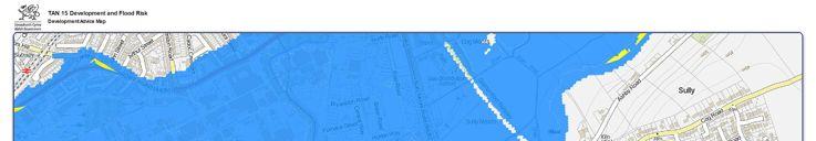
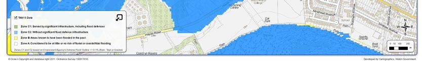
6 Flood Consequence Assessment RVW Consulting Limited TAN 15 Classification The specific guidance with regards to the classification of commercial/office premises contained in the TAN 15 Document (Figure 2) confirms that the proposed development could be classified as less vulnerable development. The TAN 15 Development Advice Map for the area indicates that the site would be categorised as a Zone C2 area, which states that it is without significant flood defence infrastructure. Flood Risk There is a risk of flooding at the development site from the 1%, 1% + climate change, and 0.1% flood event scenarios. This risk could be mitigated by the implementation of formal flood plans and procedures as part of an operating plan for the premises. This would include the erection of suitable warning signs to inform people entering the site, and the preparation of safe and effective flood warning and evacuation plans agreed with the local authority and emergency services, including subscription to Floodline Warnings Direct (as itemised in Appendix 6 of TAN 15). Floodline Warnings Direct is a free 24-hour service to registered users providing automated warnings to telephone, mobile, fax or pager. The 24 hour Floodline number is a telephone information service operated by the Environment Agency in England and Wales. Trained operators provide a 24/7 service to provide immediate advice on flood risk. They also provide a Quickdial number that allows direct access to any recorded flood warnings for the local area. Flood warnings are usually issued by Natural Resources Wales with an effective lead-time of between 12 and 24 hours before the onset of flooding around the site. Natural Resources Wales provides a comprehensive flood warning service for the River Taff. Warnings are issued to the Emergency Services, the Media and, other than for Flood Watch, to individual properties within Flood Risk Areas via the Floodline Warnings Direct service. The proposals indicate that the development will not provide for any overnight sleeping accommodation on the premises. The proposed development of the site will not result in the displacement of floodwater to the detriment of other properties. Project Number C6639
7 Flood Consequence Assessment RVW Consulting Limited 4.0 ACCEPTABILITY CRITERIA In support of the planning application, the following information is offered. 1. The proposed development will generate no flood risk, due to surface water run-off, as flows will continue to be discharged to a drainage system that is managed by the industrial estate operator. 2. There will be no loss of flood storage. 3. Flood defences are those that currently exist, and are deemed adequate for existing usage. 4. The Client is aware of the potential for flooding in this area and will implement flood management procedures, if required. 5. If considered necessary, end users and occupiers will be informed of the potential flood risk at the site so that they are aware of their duties under the Health and Safety at Work legislation, and can be duly made aware of any appropriate procedures to protect people and property. 6. Escape routes onto adjacent higher land, which is outside the extent of the flood risk zone, are available. 7. If considered necessary, formal flood plans and procedures can be established as part of an operating plan for the premises. This could include the erection of suitable warning signs to inform people entering the site, and the preparation of safe and effective flood warning and evacuation plans agreed with the local authority and emergency services, including subscription to Floodline Warnings Direct (as itemised in Appendix 6 of TAN 15). 8. Flood proofing and mitigation will be considered within the design of the development, if considered necessary. This could be undertaken in accordance with the guidance that is available from the Environment Agency using their online publication Prepare your property for flooding. Project Number C6639
8 Flood Consequence Assessment RVW Consulting Limited 5.0 CONCLUSION The size and nature of the proposed development can be categorised as less vulnerable development in accordance with TAN 15. Due to the nature of the development, the proposals do not aggravate or increase the risk of flooding to the existing site or to surrounding properties. The Client has been advised of the potential for flooding in this area and is aware of the residual risk. In summary, based upon the published guidelines and relevant provisions of the technical advice note, the proposed development meets the acceptability criteria. Project Number C6639
9 Flood Consequence Assessment RVW Consulting Limited 6.0 PLANNING DRAWINGS Project Number C6639
10
11 Flood Consequence Assessment RVW Consulting Limited 7.0 TAN 15 DEVELOPMENT ADVICE MAP AND FLOOD LEVEL INFORMATION Project Number C6639
12
13 ATIX-12630a Tank Farm Way, Sully E: N: Current Flood Map Figure 1 shows the current Flood Map (version ) at this location. The Flood Map represents a combination of the undefended fluvial and tidal flood extents derived from detailed local models and national generalised model data. Undefended scenarios are provided as being a possible worst case scenario in the event of defence failure. Please note that the current tidal flood outlines shown on the Flood Map in Figure 1 are based on an NRW Tidal Projection Mapping study (2013) that uses sea level nodes within the Severn Estuary. Each node represents a set of extreme sea levels which were generated by the Environment Agency in for current day (in the studies case, 2008). These levels were projected in-land over a digital terrain model to produce depth and elevation grids as well as tidal mapped outlines for both the 0.5% ( 200) AEP (annual exceedance probability) and the 0.1% ( 1000) AEP; including climate change and upper confidence intervals (+/-95%). These outlines offer a more precautionary picture of tidal flood risk and therefore supersede the localised hydraulic modelled outlines described in Section 2 below. More information on the Flood Map can be obtained from the Natural Resources Wales website 2. Local Flood Risk Mapping Study Model Summary The results summarised in the tables below are taken from two hydraulic models developed as part of the Cadoxton Strategic Flood Risk Assessment. These are: a. A multi-domain 1D-2D ESTRY/TUFLOW model assessing fluvial and tidal flood risk from the River Cadoxton and its tributaries the East Brook, Sully Brook and Cold Brook from just upstream of Dinas Powys to the Cadoxton sea outfall 2. The fluvial outputs below are provided from this model. b. A Tidal Inundation model extending the coastal boundary to include Barry Docks 3. The above fluvial/tidal model was adopted and modified to allow broad-scale tidal flooding within the lower Cadoxton River catchment. This model is subject to substantially more tidal inundation flooding and as such has been used to provide tidal outputs below. Results Site of Interest The polygon shown in the figures represents the site in question and has been used to query the height, depth, velocity & hazard grids to provide the results in Tables 1-6 below. NULL values indicate that the site is flood free during a particular scenario. The elevation results have been interpolated to include the climate change increment from the DEFRA guidance on extreme sea level data to show current day scenarios (see Tables 4 & 6 below). 95% confidence bounds for these values were also derived using the confidence intervals for the Newport Extreme Sea Level node. Example depth grids for the defended fluvial 100+CC and 1000, and the defended tidal 200 (2114) and 1000 (2089) including confidence intervals - are reproduced in Figures 2, 3, 5 & 6 below. Page 1 of 6
14 Example hazard grids for the defended fluvial 1000, and the defended tidal 200 year (2089) including Confidence Interval, are represented in Figures 4 & 7. The hazard rating below relates to the Hazard to People Classification using the hazard matrix 4. Flood Hazard Rating (HR) Colour Code Hazard to People Classification Less than 0.75 Very low hazard Caution 0.75 to 1.25 Danger for some includes children, the elderly and the infirm 1.25 to 2.0 Danger for most includes the general public More than 2.0 Danger for all includes the emergency services Table 1: Defended Fluvial Level Data CC 1000 Model Grid Size (m) Wet Cells Depth, mean (m) NULL Depth, max (m) NULL Elevation, mean NULL Elevation, max NULL Velocity, mean NULL Velocity, max NULL Hazard, mean NULL Hazard, max NULL Table 2: Undefended Fluvial Level Data Model Grid Size (m) 1 1 Wet Cells Depth, mean (m) Depth, max (m) Elevation, mean Elevation, max Velocity, mean Velocity, max Hazard, mean Hazard, max Page 2 of 6
15 Table 3: Defended Tidal Level Data with Climate Change (excluding upper confidence Intervals) Model Grid Size (m) Wet Cells Depth, mean (m) NULL NULL 0.09 NULL Depth, max (m) NULL NULL 0.25 NULL Elevation, mean NULL NULL 6.07 NULL Elevation, max NULL NULL 6.14 NULL Velocity, mean NULL NULL 0.08 NULL Velocity, max NULL NULL 0.49 NULL Hazard, mean NULL NULL 0.55 NULL Hazard, max NULL NULL 1.03 NULL Table 4: Interpolated Tidal Results (2016) Elevation, max NULL NULL 6.17 NULL Table 5: Defended Tidal Level Data with Climate Change (including upper confidence Intervals) Model Grid Size (m) Wet Cells Depth, mean (m) NULL Depth, max (m) NULL Elevation, mean NULL Elevation, max NULL Velocity, mean NULL Velocity, max NULL Hazard, mean NULL Hazard, max NULL Page 3 of 6
16 Table 6: Interpolated Tidal Results (2016) Elevation, max NULL Results Emergency Access to Site The access route provided was used to query the height, depth, velocity and hazard grids to provide the results in Tables NULL values indicate the site is flood free during this scenario. Table 7: Defended Fluvial Level Data CC 1000 Model Grid Size (m) Wet Cells Depth, mean (m) NULL Depth, max (m) NULL Elevation, mean NULL Elevation, max NULL Velocity, mean NULL Velocity, max NULL Hazard, mean NULL Hazard, max NULL Table 8: Undefended Fluvial Level Data Model Grid Size (m) 1 1 Wet Cells Depth, mean (m) Depth, max (m) Elevation, mean Elevation, max Velocity, mean Velocity, max Hazard, mean Hazard, max Page 4 of 6
17 Table 9: Defended Tidal Level Data with Climate Change (excluding upper confidence Intervals) Model Grid Size (m) Wet Cells Depth, mean (m) Depth, max (m) Elevation, mean Elevation, max Velocity, mean Velocity, max Hazard, mean Hazard, max Table 10: Interpolated Tidal Results (2016) Elevation, max Table 11: Defended Tidal Level Data with Climate Change (including upper confidence Intervals) Model Grid Size (m) Wet Cells Depth, mean (m) Depth, max (m) Elevation, mean Elevation, max Velocity, mean Velocity, max Hazard, mean Hazard, max Page 5 of 6
18 Table 12: Interpolated Tidal Results (2016) Elevation, max Table 13: Sea level rise, mm per year Assumed vertical land movement Additional Information We do not hold any historic flooding information for the area of interest. The local authority may be able to provide information on issues such as localised flooding from sewers, drains and culverts. 4. References Environment Agency (2011) Coastal flood boundary conditions for UK mainland and islands SC JBA Consulting (2015) Cadoxton Flood Risk Study Hydraulic Model User Report JBA Consulting (2015) Cadoxton Flood Risk Study Tidal Inundation Model Model User Report and Results Discussion Final Supplementary note on flood hazard ratings and thresholds for development planning and control purpose (May 2008) Flood and Coastal Defence Appraisal Guidance: FCDPAG3 Economic Appraisal. Supplementary Note to Operating Authorities Climate Change Impacts; October 2006; Department for Environment, Food and Rural Affairs. 5. Notes The scope of the model is the mapping of flood risk, it is not intended for detailed design. The model should be considered as the starting point for more detailed modelling, commensurate with the consequences of flooding at the site of interest. NRW models are available under licence agreement for the purpose of further development. Contact Natural Resources Wales Data Distribution team for details of terms, conditions and pricing. If the data is used in support of an FCA, please include the reference number. Please refer to NRW standard terms and conditions. Flood Risk Analysis 18/04/2017 Page 6 of 6
19 Legend Site Location Flood Zone 3 ( 100 year undefended fluvial and 200 year undefended tidal extents) Flood Zone 2 ( 1000 year undefended fluvial and tidal extents) Areas benefiting from defences!! Defences Flood Storage Area Main Rivers Access Project Drawing Tank Farm Way, Sully, CF64 5RP [Ref:ATI-12630a] Figure 1: Current Floodmap [v201704] ± Date 18th April 2017 Scale 1:5,000
20 Legend Site Location Flood Depth (m) >0.3 >0.6 >1.0 >2.0 Access Project Tank Farm Way, Sully, CF64 5RP [Ref:ATI-12630a] ± Drawing Figure 2: Fluvial Depth Grid for 1% AEP with climate change ( %) year event with Defences Date 18th April 2017 Scale 1:5,000
21 Legend Site Location Flood Depth (m) >0.3 >0.6 >1.0 >2.0 Access Project Tank Farm Way, Sully, CF64 5RP [Ref:ATI-12630a] ± Drawing Date Figure 3: Fluvial Depth Grid for 0.1% AEP ( 1000) year event with Defences 18th April 2017 Scale 1:5,000
22 Legend Site Location Flood Hazard < > 2.0 Access Project Tank Farm Way, Sully, CF64 5RP [Ref:ATI-12630a] ± Drawing Date Figure 4: Fluvial Hazard Grid for 0.1% AEP ( 1000) year event with Defences 18th April 2017 Scale 1:5,000
23 Legend Site Location Flood Depth (m) >0.3 >0.6 >1.0 >2.0 Access Project Tank Farm Way, Sully, CF64 5RP [Ref:ATI-12630a] ± Drawing Figure 5: Tidal Depth Grid for 0.5% AEP ( 200) year event - defended including upper confidence intervals (2114) Date 18th April 2017 Scale 1:5,000
24 Legend Site Location Flood Depth (m) >0.3 >0.6 >1.0 >2.0 Access Project Tank Farm Way, Sully, CF64 5RP [Ref:ATI-12630a] ± Drawing Figure 6: Tidal Depth Grid for 0.1% AEP ( 1000) year event - defended including upper confidence intervals (2089) Date 18th April 2017 Scale 1:5,000
25 Legend Site Location Flood Hazard < > 2.0 Access Project Tank Farm Way, Sully, CF64 5RP [Ref:ATI-12630a] ± Drawing Figure 7: Tidal Hazard Grid for 0.1% AEP ( 1000) year event - defended including upper confidence intervals (2089) Date 18th April 2017 Scale 1:5,000
Flood Consequence Assessment. Proposed Student Accommodation, East Bay Close, Cardiff
 Proposed Student Accommodation, East Bay Close, Cardiff Client By KDP Architects RVW Consulting 13 Seymour Terrace 6 Neptune Court Liverpool Vanguard Way L3 5PE Ocean Park Cardiff CF24 5PJ Tel: 292 461
Flood Risk and Drainage Assessment.
 Flood Risk and Drainage Assessment. Change of Use off land to Leisure Complex At, Caersws, Powys, SY17 5SB October 2018 Statement prepared for: Mr T Bebb By Woodsyde Developments Ltd Woodsyde Developments
Barton Farm Winchester. Outline Planning Application A New Suburb for Winchester. Flood Risk Assessment prepared by Parsons Brinckerhoff
 Barton Farm Winchester Outline Planning Application A New Suburb for Winchester Flood Risk Assessment prepared by Parsons Brinckerhoff November 2009 BARTON FARM WINCHESTER FLOOD RISK ASSESSMENT May 2009
Rising Sun. Scaffold Hill. Flood Risk Assessment
 Rising Sun Scaffold Hill Flood Risk Assessment August 2010 Contents 1.0 Introduction... 4 2.0 Site Description... 5 3.0 Legislative Framework... 6 4.0 Flood Risk... 10 5.0 Surface Water Drainage... 11
SITE SPECIFIC FLOOD RISK ASSESSMENT NEW STUDENT ACCOMMODATION, FASSAUGH AVENUE, CABRA, DUBLIN / F5.1 3 RD JANUARY 2018
 SITE SPECIFIC FLOOD RISK ASSESSMENT NEW STUDENT ACCOMMODATION, FASSAUGH AVENUE, CABRA, DUBLIN 7 26 098 / F5.1 3 RD JANUARY 2018 Issued For Distribution Revision Final Architect B 1 INTRODUCTION 1.1 It
Isle of Wight Strategic Flood Risk Assessment MK2. Appendix E West Wight
 Isle of Wight Strategic Flood Risk Assessment MK2 Appendix E June 2010 Isle of Wight Strategic Flood Risk Assessment Overview The RDA is comprised of the towns of Totland and Freshwater and is classified
Isle of Wight Strategic Flood Risk Assessment MK2. Appendix P Newport
 Isle of Wight Strategic Flood Risk Assessment MK2 Appendix P June 2010 Isle of Wight Strategic Flood Risk Assessment Overview Please review this discussion in conjunction with the mapping provided in this
FLOOD RESPONSE PLAN PROPOSED WASTE MANAGEMENT FACILITY AT UNIT C, MAERDY INDUSTRIAL ESTATE, RHYMNEY, TREDEGAR, NP22 5PY. On behalf of Mekatek Ltd
 FLOOD RESPONSE PLAN PROPOSED WASTE MANAGEMENT FACILITY AT UNIT C, MAERDY INDUSTRIAL ESTATE, RHYMNEY, TREDEGAR, NP22 5PY On behalf of Mekatek Ltd Our Ref: 0097.b Date: December 2016 Prepared by: JDE Unit
Phase 1 FLOOD RISK ASSESSMENT REPORT
 Phase 1 FLOOD RISK ASSESSMENT REPORT PREPARED FOR: REFERENCE #: 1916 MS Power Projects Ltd DATE: February 2014 Page 1 of 24 AMBIENTAL TECHNICAL SOLUTIONS LTD. DOCUMENT ISSUE RECORD PROJECT: PHASE 1 FLOOD
Surface Water Guidance for Developers
 Surface Water Guidance for Developers Contents Overview of Sustainable Drainage Systems (SuDS)... 2 Information Required in a Flood Risk Assessment or Drainage Strategy... 3 Outline Planning Applications...
Strategic Flood Risk Assessment (SFRA) Level 2
 Level 2") Strategic Flood Risk Assessment (SFRA) Level 2 (Final) South Bucks District Council Capswood Oxford Road Denham UB9 4LH (this page intentionally blank) Level 2 SFRA Background The South Bucks Level 1 SFRA
Strategic Flood Risk Assessment (SFRA) Level 2 (Final) South Bucks District Council Capswood Oxford Road Denham UB9 4LH (this page intentionally blank) Level 2 SFRA Background The South Bucks Level 1 SFRA
Flood Risks to CMT Estates
 s Executive Summary Whilst the proximity of Chatham Maritime to the tidal Medway tends to lead people to worry about flooding from the river, the risk of this happening is considered to be very low. Parts
Refer to Chapter 3.0 (Description of Development) for a detailed site and development description.
 for a detailed site and development description.") 7. WATER: HYDROGEOLOGY & HYDROLOGY 7.1 Introduction This chapter of the EIAR comprises of an assessment of the likely impact of the proposed development on the surrounding surface water and hydrogeological
7. WATER: HYDROGEOLOGY & HYDROLOGY 7.1 Introduction This chapter of the EIAR comprises of an assessment of the likely impact of the proposed development on the surrounding surface water and hydrogeological
Marine Licence: 12/45/MLv1
 Natural Resources Wales 29 Newport Road Cambria House Cardiff CF24 0TP Ffôn Tel: 0300 065 3000 Ebost email: marinelicensing@naturalresourceswales.gov.uk MARINE AND COASTAL ACCESS ACT 2009: PART 4 MARINE
Unique ID: (from PFRA database) Location: Newport, Co. Tipperary. Stage 1: Desktop Review
 Location: Newport, Co. Tipperary. Stage 1: Desktop Review") Location: Newport, Co. Tipperary Unique ID: 240433 (from PFRA database) Initial OPW Designation APSR AFRR IRR Co-ordinates Easting: 172620 Northing: 162375 River / Catchment / Sub-catchment Newport/Mulcair
Location: Newport, Co. Tipperary Unique ID: 240433 (from PFRA database) Initial OPW Designation APSR AFRR IRR Co-ordinates Easting: 172620 Northing: 162375 River / Catchment / Sub-catchment Newport/Mulcair
East Riding of Yorkshire Council STRATEGIC FLOOD RISK ASSESSMENT (SFRA) Level 1. APPENDIX C Surface Water Flood Hazard Mapping
 Level 1. APPENDIX C Surface Water Flood Hazard Mapping") APPENDIX C Surface Water Flood Hazard Mapping (this page intentionally left blank) Introduction Surface water or pluvial flooding can be defined as flooding which results from rainfall generated overland
APPENDIX C Surface Water Flood Hazard Mapping (this page intentionally left blank) Introduction Surface water or pluvial flooding can be defined as flooding which results from rainfall generated overland
FLOOD WARNING & EVACUATION PLAN LIMEHOUSE MARINA, LONDON DECEMBER 2010
 FLOOD WARNING & EVACUATION PLAN LIMEHOUSE MARINA, LONDON DECEMBER 2010 No 2 Smithy Farm Chapel Lane Bruera Chester CH3 6EW Tel: 01244 677060 Fax: 01244 620431 info@weetwood.net www.weetwood.net SIGNATURE
Initial OPW Designation APSR AFRR IRR Co-ordinates Easting: Northing: PFRA database comments (in italics):
:") Location: Aughinish CHP and ESB Sub Station Co. Limerick Unique ID: 240366 (from PFRA database) Initial OPW Designation APSR AFRR IRR Co-ordinates Easting: 129250 Northing: 153000 River / Catchment / Sub-catchment
Location: Aughinish CHP and ESB Sub Station Co. Limerick Unique ID: 240366 (from PFRA database) Initial OPW Designation APSR AFRR IRR Co-ordinates Easting: 129250 Northing: 153000 River / Catchment / Sub-catchment
Drainage Strategy Report
 CONSULTING ENGINEERS Report No: Date: C1014 Aug 2017 Project: Drainage Strategy Report Danygraig Works, Risca Client: P.D. Edenhall This report is provided for the benefit only of the party to whom it
Unique ID: (from PFRA database) Location: Clonfert, Co. Galway. Stage 1: Desktop Review
 Location: Clonfert, Co. Galway. Stage 1: Desktop Review") Location: Clonfert, Co. Galway Unique ID: 252906 (from PFRA database) Initial OPW Designation APSR AFRR IRR Co-ordinates Easting: 197134 Northing: 221731 River / Catchment / Sub-catchment Un-named minor
Location: Clonfert, Co. Galway Unique ID: 252906 (from PFRA database) Initial OPW Designation APSR AFRR IRR Co-ordinates Easting: 197134 Northing: 221731 River / Catchment / Sub-catchment Un-named minor
The approach to managing natural hazards in this Plan is to: set out a clear regional framework for natural hazard management,
 9 Natural Hazards 9.1 Scope and Background This chapter establishes an overall framework for natural hazard management under the RMA. It also sets out the division of responsibilities between the Regional
WATER RESOURCES ACT 1991 THE WALES ROD AND LINE (SALMON AND SEA TROUT) BYELAWS 2017 THE WALES NET FISHING (SALMON AND SEA TROUT) BYELAWS 2017
 BYELAWS 2017 THE WALES NET FISHING (SALMON AND SEA TROUT) BYELAWS 2017") WATER RESOURCES ACT 1991 THE WALES ROD AND LINE (SALMON AND SEA TROUT) BYELAWS 2017 THE WALES NET FISHING (SALMON AND SEA TROUT) BYELAWS 2017 DOCUMENT NRW/6A SUMMARY PROOF OF EVIDENCE OF ROBERT VAUGHAN
WATER RESOURCES ACT 1991 THE WALES ROD AND LINE (SALMON AND SEA TROUT) BYELAWS 2017 THE WALES NET FISHING (SALMON AND SEA TROUT) BYELAWS 2017 DOCUMENT NRW/6A SUMMARY PROOF OF EVIDENCE OF ROBERT VAUGHAN
COLDRA WOODS HOTEL BY CELTIC MANOR AND STARBUCKS DRIVE- THRU RESTAURANT Flood Consequences Assessment
 COLDRA WOODS HOTEL BY CELTIC MANOR AND STARBUCKS DRIVE- THRU RESTAURANT Flood Consequences Assessment APRIL 2017 CONTACTS JOSHUA MOORE Graduate Hydrologist dd ++44 (0) 117 372 1238 joshua.moore@arcadis.com
15: DEVELOPMENT AND FLOOD RISK
 Planning Policy Wales Technical Advice Note 15: DEVELOPMENT AND FLOOD RISK July 2004 This document is one of a series of Technical Advice Notes (TANs) which supplement Planning Policy Wales. Further information
Afon Claerwen Hydropower Project. Flood Risk Assessment. February 2018
 Afon Claerwen Hydropower Project Flood Risk Assessment February 2018 Hydropower Consultancy & Development Document Control Scheme Name: Client Name: Client Address: Afon Claerwen Hydropower Project Elan
Ryde/Binstead. Flood Investigation Report
 Ryde/Binstead Flood Investigation Report Flood Investigation Report Document Information Document Information Document Reference 2013-IWC-LLFA-009-13 Document Revision Report Status FINAL Date 24 June
Secure Training Facility
 Secure Training Facility Cardiff Flood Consequence Assessment Final report January 2017 Hydrock Reference: C-04330-C Issued by: Project: Title: Status: Hydrock Consultants Limited Over Court Barns Over
DOUGHTY ROAD, GRIMSBY Flood Risk Assessment and Surface Water Drainage Strategy DECEMBER 2017
 Flood Risk Assessment and Surface Water Drainage Strategy DECEMBER 2017 CONTACTS SARAH DEMETRIOU Graduate Flood Modeller dd 0117 313 6152 e sarah.demetriou@arcadis.com Arcadis. 2 Glass Wharf Temple Quay
( THE M4 CORRIDOR AROUND NEWPORT SCHEME )
") PUBLIC INQUIRY IN THE MATTER OF THE HIGHWAYS ACT 1980 AND THE ACQUISITION OF LAND ACT 1981 AND IN THE MATTER OF: THE M4 MOTORWAY (JUNCTION 23 (EAST OF MAGOR) TO WEST OF JUNCTION 29 (CASTLETON) AND CONNECTING
PUBLIC INQUIRY IN THE MATTER OF THE HIGHWAYS ACT 1980 AND THE ACQUISITION OF LAND ACT 1981 AND IN THE MATTER OF: THE M4 MOTORWAY (JUNCTION 23 (EAST OF MAGOR) TO WEST OF JUNCTION 29 (CASTLETON) AND CONNECTING
Proposed Tidal Lagoon Development, Cardiff, South Wales
 Proposed Tidal Lagoon Development, Cardiff, South Wales Evidence Plan Framework August 2015 www.tidallagooncardiff.com Document title Evidence Plan Framework Document reference Revision number 0.4 Date
Surface water flood risk mapping in the UK - approaches and challenges
 Slide 1 Surface water flood risk mapping in the UK - approaches and challenges Slide 2 Surface water flood risk mapping in the UK Chris Elms, Department for Environment, Food and Rural Affairs Selena Peters,
Flood Risk Assessment. Reach Community Solar Farm
 Flood Risk Assessment Reach Community Solar Farm Andy Rankin 4 th February 2014 Introduction 1.1 Reach is a village of approximately 100 households on the edge of the Fens. We intend to construct a small
FORMER SHEEP PEN MILL LANE WELSHPOOL FLOOD CONSEQUENCES ASSESSMENT LIDL UK GMBH FOR. September Our Ref: RCEF R
 FORMER SHEEP PEN MILL LANE WELSHPOOL FLOOD CONSEQUENCES ASSESSMENT FOR LIDL UK GMBH Our Ref: RCEF32271-002 R RPS Health, Safety & Environment Unit 12 Watersedge Business Park Modwen Rd, Salford Quays M5
Surface water is the rainwater that runs off roofs, roads and paved areas into the public sewerage system.
 This standard advice note is intended to provide clear guidance for all developers, and planning authorities regarding surface water design and management. It should also be used to inform development
A part of BMT in Energy and Environment Kosciusko Avenue Main Drain Catchment Drainage / Flood Study Draft Report
 A part of BMT in Energy and Environment Kosciusko Avenue Main Drain Catchment Drainage / Flood Study Draft Report R.M7299.003.00.DraftReport January 2011 Kosciusko Avenue Main Drain Catchment Drainage
The movement of construction vehicles is predicted to: give rise to some measurable increases in the early morning and evening;
 5 TRAFFIC AND TRANSPORT 5.1 SUMMARY OF RESIDUAL IMPACTS The movement of construction vehicles is predicted to: give rise to some measurable increases in the early morning and evening; be outside of the
Attachment 12 Stage 1 Flood Risk Assessment (IE RP-0001)
") IE0311133-22-RP-0001, Issue A 17/10/2013 Attachment 12 Stage 1 Flood Risk Assessment (IE0311133-30-RP-0001) IE0311133-22-RP-0001_A_02.DOC Flood Risk Assessment Celebrating 40 Years in Business Jazz Pharmaceuticals
IE0311133-22-RP-0001, Issue A 17/10/2013 Attachment 12 Stage 1 Flood Risk Assessment (IE0311133-30-RP-0001) IE0311133-22-RP-0001_A_02.DOC Flood Risk Assessment Celebrating 40 Years in Business Jazz Pharmaceuticals
11 HYDROLOGY, HYDROGEOLOGY AND DRAINAGE
 11 HYDROLOGY, HYDROGEOLOGY AND DRAINAGE 11.1 introduction 11.1.1 The objective of this section and the statements presented is to assess the existing hydrological and hydrogeological conditions to understand
Rutherglen (Potentially Vulnerable Area 11/14) Local Plan District Clyde and Loch Lomond Local authority Glasgow City Council, South Lanarkshire Counc
 Local Plan District Clyde and Loch Lomond Local authority Glasgow City Council, South Lanarkshire Counc") Rutherglen (Potentially Vulnerable Area 11/14) Local Plan District Clyde and Loch Lomond Local authority Glasgow City Council, South Lanarkshire Council Main catchment Cityford Burn Summary of flooding
Rutherglen (Potentially Vulnerable Area 11/14) Local Plan District Clyde and Loch Lomond Local authority Glasgow City Council, South Lanarkshire Council Main catchment Cityford Burn Summary of flooding
This document was endorsed by Cambridgeshire County Council (CCC) in its capacity as Lead Local Flood Authority on 14 July 2016.
 in its capacity as Lead Local Flood Authority on 14 July 2016.") Note to the reader Note to the reader This document was endorsed by Cambridgeshire County Council (CCC) in its capacity as Lead Local Flood Authority on 14 July 2016. Once adopted as a Supplementary Planning
Note to the reader Note to the reader This document was endorsed by Cambridgeshire County Council (CCC) in its capacity as Lead Local Flood Authority on 14 July 2016. Once adopted as a Supplementary Planning
Application Pack 5. How to apply for a Connection to a Public Sewer/Lateral Drain
 Application Pack 5 How to apply for a Connection to a Public Sewer/Lateral Drain Guidance Notes The provisions of the Water Industry Act 1991 (WIA91) take precedence over these notes. We recommend that
City Development Plan Variation No. 7 Marina Park - Pairc Ui Chaoimh
 City Development Plan Variation No. 7 Marina Park - Pairc Ui Chaoimh Strategic Environmental Assessment (SEA) Screening Report 25 th November 2011 Cork City Council Comhairle Cathrach Chorcaí Proposed
Respond! Housing Association. Residential Development at Flinters Field, Athy, Co. Kildare. Engineering Report. Job No. : Date: April 2017
 Job No. : 16036 Date: April 2017 Respond! Housing Association Residential Development at Flinters Field, Athy, Co. Kildare Engineering Report 2B Richview Office Park Clonskeagh Dublin 14 Contents Amendment
( THE M4 CORRIDOR AROUND NEWPORT )
") PUBLIC INQUIRY IN THE MATTER OF THE HIGHWAYS ACT 1980 AND THE ACQUISITION OF LAND ACT 1981 AND IN THE MATTER OF: THE M4 MOTORWAY (JUNCTION 23 (EAST OF MAGOR) TO WEST OF JUNCTION 29 (CASTLETON) AND CONNECTING
PUBLIC INQUIRY IN THE MATTER OF THE HIGHWAYS ACT 1980 AND THE ACQUISITION OF LAND ACT 1981 AND IN THE MATTER OF: THE M4 MOTORWAY (JUNCTION 23 (EAST OF MAGOR) TO WEST OF JUNCTION 29 (CASTLETON) AND CONNECTING
MAUREEN SMITH PROPOSED RESIDENTIAL DEVELOPMENT: 121 NESS ROAD, SHOEBURYNESS, SOUTHEND ON SEA FLOOD RISK ASSESSMENT
 WARD MAUREEN SMITH PROPOSED RESIDENTIAL DEVELOPMENT: 121 NESS ROAD, SHOEBURYNESS, SOUTHEND ON SEA HOMES FLOOD RISK ASSESSMENT REPORT REF. 170090-01 PROJECT NO. 170090 APRIL 2017 121 NESS ROAD, SHOEBURYNESS
Developments of National Significance
 Developments of National Significance Guidance for Applicants Version History: Document Date Summary of Changes Version Published 1.0 May-2017 Document created Review Date: May 2018 Published by: Natural
Land North East of Blandford
 Land North East of Blandford On behalf of Savills Plc Project Ref: 36965/4001 Rev: B Date: February 2016 Office Address: Lakeside House, Blackbrook Business Park, Blackbrook Park Avenue, Taunton TA1 2PX
Irvine to Troon (Potentially Vulnerable Area 12/07) Local Plan District Local authority Main catchment North Ayrshire Council, Ayrshire Monkton to Irv
 Local Plan District Local authority Main catchment North Ayrshire Council, Ayrshire Monkton to Irv") Irvine to Troon (Potentially Vulnerable Area 12/07) Local Plan District Ayrshire Local authority North Ayrshire Council, South Ayrshire Council Main catchment Monkton to Irvine coastal Summary of flooding
Irvine to Troon (Potentially Vulnerable Area 12/07) Local Plan District Ayrshire Local authority North Ayrshire Council, South Ayrshire Council Main catchment Monkton to Irvine coastal Summary of flooding
Developers Guide for Surface Water Management.
 Developers Guide for Surface Water Management www.southwark.gov.uk Contents 1. Introduction... 2 2. Requirements for Flood Risk Assessments and Drainage Strategies... 3 2.1 Planning Applications... 3 2.2
MEMORANDUM OF UNDERSTANDING THE FLOW OF THE RIVER THROUGH CIRENCESTER
 1. Introduction MEMORANDUM OF UNDERSTANDING THE FLOW OF THE RIVER THROUGH CIRENCESTER 1.1 The control and distribution of fluvial flow through Cirencester is manually controlled by the operation of sluice
( THE M4 CORRIDOR AROUND NEWPORT SCHEME )
") PUBLIC INQUIRY IN THE MATTER OF THE HIGHWAYS ACT 1980 AND THE ACQUISITION OF LAND ACT 1981 AND IN THE MATTER OF: THE M4 MOTORWAY (JUNCTION 23 (EAST OF MAGOR) TO WEST OF JUNCTION 29 (CASTLETON) AND CONNECTING
PUBLIC INQUIRY IN THE MATTER OF THE HIGHWAYS ACT 1980 AND THE ACQUISITION OF LAND ACT 1981 AND IN THE MATTER OF: THE M4 MOTORWAY (JUNCTION 23 (EAST OF MAGOR) TO WEST OF JUNCTION 29 (CASTLETON) AND CONNECTING
River Basin Management Plan Dee River Basin District. Annex M: Competent authorities
 River Basin Management Plan Dee River Basin District Contents M1 Introduction 2 M2 Names and addresses of competent authorities 2 M3 Geographical coverage of river basin district 3 M4 Legal status of competent
Flood Hazard Assessment of Potential Growth Areas Palmerston North City: Ashhurst
 Flood Hazard Assessment of Potential Growth Areas Palmerston North City: Ashhurst Report prepared for Palmerston North City Council by Philip Wallace River Edge Consulting Limited May 2013 Table of Contents
ABERDEEN HARBOUR EXPANSION PROJECT November Volume 2: Environmental Statement. Chapter 8: FLOOD RISK AND SURFACE WATER
 ABERDEEN HARBOUR EXPANSION PROJECT November 2015 Volume 2: Environmental Statement Chapter 8: FLOOD RISK AND SURFACE WATER 8. FLOOD RISK AND SURFACE WATER 8.1 Introduction This chapter presents an assessment
Proposed Strategic Housing Development at the Former Doyles Nursery, Garden Centre and Benoni, Brennanstown Road, Cabinteely, Dublin 18
 Proposed Strategic Housing Development at the Former Doyles Nursery, Garden Centre and Benoni, Brennanstown Road, Cabinteely, Dublin 18 Flood Risk Assessment Report Vimovo Doyles Limited Project Number:
6 SUMMARY OF CUMULATIVE AND INDIRECT EFFECTS 6.1 INTRODUCTION
 6 SUMMARY OF CUMULATIVE AND INDIRECT EFFECTS 6.1 INTRODUCTION Cumulative and indirect effects result from the combined impacts of multiple projects / plans. Their consideration is important as the impacts
Action plans for hotspot locations
 Action plans for hotspot locations Ash Vale North 1. Local evidence indicates the culvert could not discharge during December 2013 because the outlet was blocked on the western side of the railway. Guildford
FLOOD RISK ASSESSMENT DAMHEAD CREEK 2 POWER STATION
 FLOOD RISK ASSESSMENT DAMHEAD CREEK 2 POWER STATION Name Job Title Date Prepared Joanne Somerton Senior Consultant (Flood Risk) 14/01/2016 Checked Kerry Whalley Technical Director 04/02/2016 Technical
YORKSHIRE WATER SERVICES. Humbercare Sewerage Network Analysis
 YORKSHIRE WATER SERVICES Humbercare Sewerage Network Analysis Page 1 July 2008 1 Summary 1.1 Introduction 1.1.1 Following flooding in Hull in June 2007 we have been asked by Ofwat to investigate, model
Storm Water Management
 Storm Water Management Policy September 2014 2 Sustainable drainage feature designed to control and manage flows through a series of check dams 3 Document Name: Storm Water Management Controlled Copy No:
TOWN LINE BROOK URBAN WATERSHED STUDY MODELING INCREMENTAL IMPROVEMENTS
 TOWN LINE BROOK URBAN WATERSHED STUDY MODELING INCREMENTAL IMPROVEMENTS Marcus M. Quigley, P.E., Project Engineer, GeoSyntec Consultants Steven P. Roy, Associate, GeoSyntec Consultants Lawrence Gil, North
Project Mensa Flood Risk Assessment. Final Report 23 December 2008
 Project Mensa Flood Risk Assessment Final Report 23 December 2008 This page is left intentionally blank for double sided printing L Project Mensa Flood Risk Assessment 23 December 2008 Notice This report
DRAINAGE SUBMITTAL CHECKLIST
 Project Name: Firm Name: Map ID: Engineer: Address: City: State: Zip: Phone Number: Fax Number: Property Owner: Address: City: State: Zip: Reviewed By: Date Received: Date Accepted for Review: The following
Environment Agency Incident Response. John Elliott, Resilience Team Leader
 Environment Agency Incident Response John Elliott, Resilience Team Leader January 2015 Overview Local Structure Pollution incident response Flood incident response. Flood planning Solent & South Downs
Water Q1 (The Quadrant) Boston April Q1 (The Quadrant) Boston Flood Risk Assessment
 Boston April Q1 (The Quadrant) Boston Flood Risk Assessment") Water Q1 (The Quadrant) Boston April 2014 Q1 (The Quadrant) Boston Flood Risk Assessment Prepared by Anna Gee Checked by Matthew Wilson Graduate Flood Risk Consultant Senior Engineer Approved by: Graham
Water Q1 (The Quadrant) Boston April 2014 Q1 (The Quadrant) Boston Flood Risk Assessment Prepared by Anna Gee Checked by Matthew Wilson Graduate Flood Risk Consultant Senior Engineer Approved by: Graham
Our Ref: MJ: L.M doc. 5 May TGM Group Level 1, Myers Street, PO Box 1137 Geelong Vic Attention: Chris Marshall.
 BMT WBM Pty Ltd Level 5, 99 King Street MELBOURNE VIC 3000 Australia PO Box 604 Collins Street West VIC 8007 Tel: +61 3 8620 6100 Fax: +61 3 8620 6105 ABN 54 010 830 421 www.wbmpl.com.au Our Ref: MJ: L.M7076.001.doc
The Provision of First Time Sewage Treatment for the catchment at Laxey, Isle of Man
 The Provision of First Time Sewage Treatment for the catchment at Laxey, Isle of Man Briefing Document June 2017 Page 1 of 13 Contents 1 Introduction... 3 2 Background Information... 3 2.1 Laxey... 3 2.2
Francis Sant. Proposed Free Range Poultry Unit, Pentrefelin, Llandeilo Flood Consequence Assessment. January 2018 Final Revision C SITE
 Francis Sant Proposed Free Range Poultry Unit, Pentrefelin, Llandeilo Flood Consequence Assessment SITE Final Revision C Project Document Status Revision Proposed Free Range Poultry Unit, Pentrefelin,
(Old examination format for reference only)
") The Institution of Structural Engineers Associate-Membership Examination 11 APRIL 2003 INSTRUCTIONS TO CANDIDATE 1. The examination comprises two sessions separated by a lunch break of 1 2 hour, during
The Institution of Structural Engineers Associate-Membership Examination 11 APRIL 2003 INSTRUCTIONS TO CANDIDATE 1. The examination comprises two sessions separated by a lunch break of 1 2 hour, during
a. Title of Report Example: Final Hydrologic and Hydraulic Drainage Report For Tract #### (or Planning and Zoning Permit ##-###-###)
") CITY OF OXNARD ENGINEERING DIVISION REQUIRED FORMAT AND CONTENTS HYDROLOGIC AND HYDRAULIC DRAINAGE REPORTS This report will provide a basis for design of the drainage system for the subject project. The
CITY OF OXNARD ENGINEERING DIVISION REQUIRED FORMAT AND CONTENTS HYDROLOGIC AND HYDRAULIC DRAINAGE REPORTS This report will provide a basis for design of the drainage system for the subject project. The
7. NATURAL HAZARDS 7.1 SECTION INTRODUCTION
 7. NATURAL HAZARDS 7.1 SECTION INTRODUCTION 7.1.1 The Resource Management Act empowers Council to control any actual or potential effects of the use, development, or protection of land for the purpose
PLYMOUTH ROAD, PLYMPTON, PLYMOUTH. FLOOD RISK ASSESSMENT. On Behalf of. Lidl UK.
 PLYMOUTH ROAD, PLYMPTON, PLYMOUTH. FLOOD RISK ASSESSMENT On Behalf of Lidl UK Date: Our Ref: JER6216 RPS 34 Lisbon Street Leeds West Yorkshire LS1 4LX Tel: (0)113 220 6190 Email: rpslds@rpsgroup.com Quality
The Environment Agency s Objectives and Contributions to Sustainable Development: Statutory Guidance
 The Environment Agency s Objectives and Contributions to Sustainable Development: Statutory Guidance by the Secretary of State for Environment, Food and Rural Affairs The Environment Agency s Objectives
Statement of Particulars Western Wales Flood Risk Management Plan
 Statement of Particulars Western Wales Flood Risk Management Plan FINAL 22 September 2015 Date Our purpose is to ensure that the natural resources of Wales are sustainably maintained, used and enhanced,
Good Practice Guide. Technical Guidance: Flood risk activity exemptions Date Published: April GPG 221 Document Owner: Flood Risk Strategy
 Good Practice Guide Technical Guidance: Flood risk activity exemptions Date Published: April 2016 GPG 221 Document Owner: Flood Risk Strategy Page 1 of 41 Version History: Document Date Summary of Changes
Appendix 15.3 Hydraulic Assessment of Sewers
 Appendix 15.3 Hydraulic Assessment of Sewers Irish Water Arklow Wastewater Treatment Plant Project EIA Report Issue September 2018 Arup \\GLOBAL\EUROPE\DUBLIN\JOBS\247000\247825-00\4. INTERNAL\4-03 DESIGN\4-03-02
Hawick Flood Protection Scheme
 Hawick Flood Protection Scheme Document: R004 Version: 1.1 Stages 2 & 3 (Part 2): Option Appraisal Non Technical Summary Scottish Borders Council 7 March 2013 Stages 2 & 3 (Part 2): Option Appraisal -
GRIMSBY TIDAL DEFENCES: WAVE OVERTOPPING AND COASTAL FLOODING
 14 May 2013 GRIMSBY TIDAL DEFENCES: WAVE OVERTOPPING AND COASTAL FLOODING EMAY TOHA B&V WATER INTRODUCTION, CONTENTS AND WHY GRIMSBY? 2 I N T R O D U C T I O N S & C O N T E N T S INTRODUCTIONS Senior
Scottish Hydrological Group Meeting, 13 th November Surface water management plans in action Case studies in Kent.
 Scottish Hydrological Group Meeting, 13 th November 2013. Surface water management plans in action Case studies in Kent Paul Eccleston Topics Prioritisation and broad-scale surface water mapping Case study
From: John D. Hines, P.E. Re: Old Dominion University Campus Master Plan Sea Level Rise Narrative
 Transportation Land Development Environmental S e r v i c e s Two Columbus Center 4500 Main Street, Suite 400 Virginia Beach, Virginia 23462 Telephone 757 490 0132 Fax 757 490 0136 Memorandum To: File
FLOOD RISK ASSESSMENT
 Firth Buildings, 99-101 Leeds Road, Dewsbury, WF12 7BU t 01924 464342 f 01924 450662 e trevor.haigh@haighhuddleston.co.uk FLOOD RISK ASSESSMENT ON LAND AT BUTT LANE SNAITH WEST YORKSHIRE FOR HARRON HOMES
Habitats Regula ons Assessment. Border Group Neighbourhood Area Addendum
 Habitats Regula ons Assessment Border Group Neighbourhood Area Addendum November 2016 Contents 1.0 Introduction 1 2.0 Screening of proposed modifications to the NDP 1 3.0 Summary of main findings 1 4.0
Portsmouth Flood Alleviation Scheme part of Southern Water s 50m programme of improvements to the sewer network in Portsmouth
 www.projectsonline.com water & Sewerage Portsmouth Flood Alleviation Scheme part of Southern s 50m programme of improvements to the sewer network in Portsmouth by Robert McTaggart BEng CEng CIWEM P ortsmouth
Engineers Ireland Presentation
 Engineers Ireland Presentation Kevin Gallagher Chartered Engineer Senior Executive Engineer Cork City Council Local Authority Response to Flooding in an Urban Area INTRODUCTION: Context Flooding Types
Adoption of sewers. Application for the adoption of a sewer under Section 104 of the Water Industry Act Section 1A: Applicant s details
 Adoption of sewers Application for the adoption of a sewer under Section 104 of the Water Industry Act 1991 NOTE: Please ensure all relevant sections of the application are completed and refer to the attached
South Cambridgeshire and Cambridge City Level 1 Strategic Flood Risk Assessment South Cambridgeshire District Council and Cambridge City Council
 South Cambridgeshire and Cambridge City Level 1 Strategic Flood Risk Assessment South Cambridgeshire District Council and Cambridge City Council September 2010 Contents EXECUTIVE SUMMARY 1 Glossary 3
determine the effect of the Proposed Development together with the other planned changes within defined areas of influence;
 14 SUMMARY OF CUMULATIVE AND INDIRECT EFFECTS 14.1 INTRODUCTION Cumulative and indirect effects result from the combined impacts of multiple projects / plans. Their consideration is important as the impacts
Requisition a public sewer and/or lateral drain
 Please ensure you have read our guidance notes before completing this application form and include as much information as possible. If mandatory fields (marked with a ) are not completed this could result
Developing a local flood risk management strategy Annex 1: Flooding, flood sources and flood defences
 Developing a local flood risk management strategy Annex 1: Flooding, flood sources and flood defences Pennine Water Group, University of Sheffield in collaboration with the partners of the FloodResilienCity
INTEGRATED FLOOD MANAGEMENT IN SAMOA
 INTEGRATED FLOOD MANAGEMENT IN SAMOA From Science to Policy Amataga Penaia 1, Ausetalia Titimaea 1, Jude Kohlhase 1, Filomena Nelson 1, Netatua Pelesikoti 2, Michael Bonte-Grapentin 2, Litea Biukoto 2,
Guidance notes for developers
 Guidance notes for developers - adoption of sewers. Section 104 of the Water Industry Act 1991 Foreword These guidelines are designed to be used in conjunction with the current version of Sewers for Adoption
TULLAMORE FLOOD RISK ASSESSMENT AND MANAGEMENT STUDY
 TULLAMORE FLOOD RISK ASSESSMENT AND MANAGEMENT STUDY FINAL HYDRAULICS REPORT 1794/RP/004/C June 2008 FRAM Section Engineering Services Office of Public Works Doc. No. 1794/RP/004/C ii June 2008 INDEX OF
Wellington Dock Planning Application, Liverpool. Non-Technical Summary for Environmental Statement
 Wellington Dock Planning Application, Liverpool Non-Technical Summary for Environmental Statement INTRODUCTION United Utilities PLC (UU) has applied for planning permission for an extension to Liverpool
Hazardous Substances Hazardous Substances Explanatory Statement Significant Issues Objective and Policies...
 Section Contents Hazardous Substances... 2 9. Hazardous Substances... 2 Explanatory Statement... 2 9.1 Significant Issues... 3 9.2 Objective and Policies... 3 9.3 Activity Lists... 4 9.4 Quantity thresholds
Prestwick and Ayr (Potentially Vulnerable Area 12/09) Local Plan District Ayrshire Local authority South Ayrshire Council Main catchment Doonfoot to M
 Local Plan District Ayrshire Local authority South Ayrshire Council Main catchment Doonfoot to M") Prestwick and Ayr (Potentially Vulnerable Area 12/09) Local Plan District Ayrshire Local authority South Ayrshire Council Main catchment Doonfoot to Monkton coastal Summary of flooding impacts At risk
Prestwick and Ayr (Potentially Vulnerable Area 12/09) Local Plan District Ayrshire Local authority South Ayrshire Council Main catchment Doonfoot to Monkton coastal Summary of flooding impacts At risk
Luton Level 1 SFRA Update. February 2013
 Luton Level 1 SFRA Update February 2013 Quality Management Job No Title Location CS/060431 Luton Level 1 SFRA update Luton Borough Council Document Ref N/A Issue / Revision Final Date 8 February 2013 Prepared
Contractors Code of Practice
 Estates and Facilities Department of the University of Bradford In partnership with ICT Services Contractors Code of Practice Issue Date Comments 1 st Draft 2 nd Draft Issued 19/5/2010 Distributed as per
Integrated flood modelling and mitigation analysis 8 th Australasian Natural Hazards Management Conference (ANHMC2015)
") Integrated flood modelling and mitigation analysis 8 th Australasian Natural Hazards Management Conference (ANHMC2015) Raymond Cohen Mahesh Prakash James Hilton Yunze Wang Fletcher Woolard 3:45-4:15pm
Integrated flood modelling and mitigation analysis 8 th Australasian Natural Hazards Management Conference (ANHMC2015) Raymond Cohen Mahesh Prakash James Hilton Yunze Wang Fletcher Woolard 3:45-4:15pm
Environment Agency Guidance on Requirements for Land Contamination Reports. July 2005
 Environment Agency Guidance on Requirements for Land Contamination Reports July 2005 ENVIRONMENT AGENCY GUIDANCE ON REQUIREMENTS FOR LAND CONTAMINATION REPORTS Context Who is this guidance aimed at? Developers,
SEARs climate change risk and adaptation
 25 Climate change risk and adaptation The NSW Government has acknowledged that, despite efforts to reduce greenhouse gas emissions, some climate change is now inevitable. The Government aims to minimise