Integrated flood modelling and mitigation analysis 8 th Australasian Natural Hazards Management Conference (ANHMC2015)
|
|
|
- Norma Craig
- 5 years ago
- Views:
Transcription

 Raymond Cohen Mahesh")

1 Integrated flood modelling and mitigation analysis 8 th Australasian Natural Hazards Management Conference (ANHMC2015) Raymond Cohen Mahesh Prakash James Hilton Yunze Wang Fletcher Woolard 3:45-4:15pm Wednesday 14 October

2 Background
3 Motivations Australian councils are required to manage risk associated with areas that are prone to flooding from storm surge, heavy rainfall and catchment flooding Simultaneous combinations of these events are especially challenging Step 1: Identify present and future flood risk Computational simulations of worst case conditions now and in the future Make land use and planning decisions based on these results Step 2: Propose mitigation strategies to reduce impact of flood events Use computational modelling to determine delivered benefits of each strategy Evaluate cost/benefit options Make informed decisions for how to optimally allocate funds Could just be one option over another Attack / defend / withdraw
4 Swift Hydrodynamic Model Water depth << width 2D formulation Predicts water height, momentum Shallow water finite volume model depth width Dam breaks Flash flooding Coastal inundation


5 Swift Hydraulic Model Pressure head-based pipe network model Assume sound speed >> gravity wave speed Pipe network both helps and hinders flooding: Normal conditions: Drainage reversal: Drainage flow direction = Drainage flow direction = Storm tide

6 Swift Flood Modelling Framework Integrated hydrodynamic/hydraulic flood modelling Modular & flexible Very fast - GPU accelerated code Capable of investigating storm surge, extreme rainfall, catchment flooding, sea level rise Able to study mitigation options in an integrated manner Developing software front end C-FAST aimed specifically for Australian councils and to be used by council engineers

7 Case studies CSIRO been involved in a number of flood modelling studies Today we will discuss: City of Port Phillip Shire of Murray City of Bunbury (current)
8 City of Port Phillip (CoPP)

9 Port Phillip Bay and CoPP CoPP Largest embayment in the world CoPP is one of 10 cities around the bay Legacy of engineering problems


10 CoPP 100,000 residents and over 22,000 businesses. Population likely to double in next years due to development at Fishermans Bend Elwood Swamp 1886 Structural mitigation options: Levees, basins and dams Drainage networks
11 Project goals From a practical engineering or on-ground management perspective, want to understand what combinations of mitigation solutions work: Adaptation type (examples) Upstream retention/ detention & diversion pipes On-lot retention/detention Mitigates what type(s) of flooding? For what period? At what cost??????? Offshore reef??? Back valves???
12 Model inputs Council wide terrain and bathymetry (LiDAR) Hydraulic and Hydrological (eg. drainage network) Storm surge with a peak of 1.3 m 1 in a 100 ARI rainfall for 3 hrs (also 1 in 5 and 1 in 10 ARI) Total simulation time = 24 hrs Rainfall starts at peak storm surge No upstream storm water reception (except in main drains) Sea level rise (SLR) = current day, 0.4, 0.8 and 1.1 m

13 Hydrodynamic Model City of Port Phillip Extensive urban drainage network (~13k pipes) Model effects of 1.3 m storm surge Flow reversal back up the drainage network is critical feature to model for CoPP 0.1 m 3 /s Flow rate 0 m 3 /s N
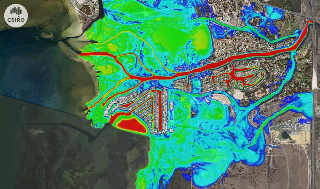
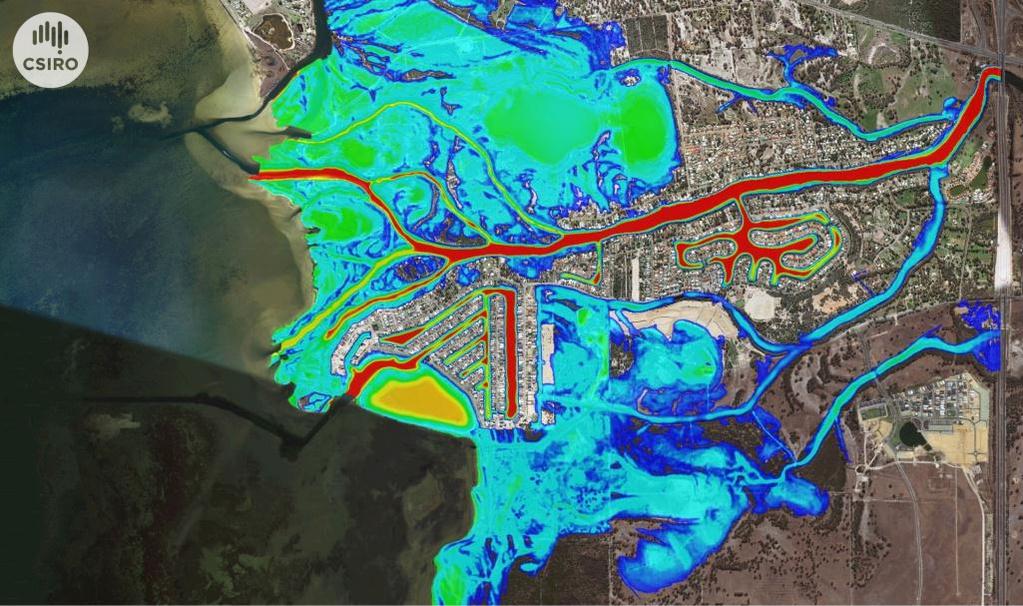
14 Flood visualisation current day

15 Flood summary current day Areas affected Elwood, Middle Park, Beacon Cove, South Melbourne Flood type mostly nuisance (0 to 0.3 m for less than 1 hr) except small sections around Elwood and South Melbourne Retention time

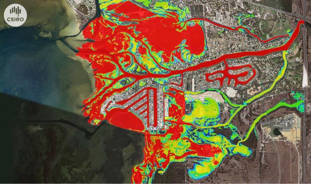
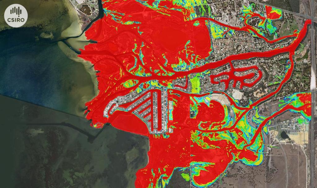
16 Flood visualisation SLR 1.1 m
17 Flood summary current day Areas affected Elwood, Middle Park, Beacon Cove, South Melbourne Flood type severe flooding in all parts affected including very alarming long lived flooding (> 12 hrs+) around most parts of Elwood canal, South Melbourne and Middle Park Retention time

18 Mitigation options applied
 Without mitigation With mitigation Retention time Focus area Elwood canal Mitigation")
19 Mitigation summary SLR 0.0 m (current day) Without mitigation With mitigation Retention time Focus area Elwood canal Mitigation achieved Flooding at intersection of Barkly and Meredith street completely stopped
20 Shire of Murray (SoM)
 where they flow into the Peel estuary in South Yunderup WA Areas of cultural,")

21 SoM Project Murray (and Serpentine) river delta Series of eight low lying islands and coastal areas At the confluence of two rivers (the Murray and the Serpentine) where they flow into the Peel estuary in South Yunderup WA Areas of cultural, heritage and future infrastructure value A combination of several factors puts the delta at high risk, including Sea level rise Increased frequency and severity of storm surges Greater tidal influence and salinity Poorly planned protection measures

22 SoM topography and bathymetry
23 SoM simulation cases Case Sea level Simulation description (above 2014 AHD) m Current day with storm surge m 2030 with storm surge m 2070 with storm surge m 2100 with storm surge

24 SLR 0.0 m SLR 0.14 m SLR 0.4 m SLR 0.8 m

25 SLR 0.0 m SLR 0.14 m SLR 0.4 m SLR 0.8 m
26 Findings Heritage listed Mill on the western Tip of Culeenup SLR 0.0 m - only nuisance flooding SLR 0.14 m - significantly flooded m persisting for 8+ hours Money would be better spent protecting the Mill prior to investing in restoration Homes in the Murray Delta in the three inhabited islands SLR 0.0 m, 0.14 m - inundation minimal SLR 0.4 m - 40% homes inundated SLR 0.8 m - whole of Yunderup Island is inundated Mitigation options prove ineffective from a cost/benefit perspective due to the scale and extent of flooding. Might be some benefit in investigating basic mitigation such as a levee or barrier perhaps for Yunderup Island where the extent of flooding is less dramatic
27 City of Bunbury (CoB)


28 CoB Flood mitigation analysis City of Bunbury (CoB) is a developing low-lying coastal region especially susceptible to flooding from combined storm surge and rainfall events Areas around the Preston River and the Leschenault Inlet historically worst hit WA-NDRP project to study flooding for future planning needs and to assess mitigation options Investigation into extreme present and future (with SLR) flooding events and the impact of potential mitigations including Retention/detention schemes Changes to the drainage network e.g. back valves, additional pipes Changes to pumping stations Sea walls


29 Data collection Input data types Lidar, bathymetry, land usage Drainage network, pumps Rainfall Tides Joint probability analysis Statistical extreme tide & rainfall scenarios

30 Scenarios to be considered A. Extreme rainfall into 5 Mile Brook sub-catchment B. Storm surge into northern Bunbury C. Preston River response to heavy rainfall

31 A. Extreme rainfall Five Mile Brook sub-catchment Issue: Extreme rainfall from new Dalyellup development will drain into Five Mile Brook. Impact on Bunbury pipe network is unknown. Mitigation option Prescribe maximum inflow allowance

32 B. Storm surge Impact on northern Bunbury Issue: Storm surge and SLR has the capacity to overtop Koombana Drive and to flood Leschenault Inlet / northern Bunbury Mitigation options New sea wall Permanently close storm surge barrier and lower water level of Leshenault Inlet

33 C. Preston river Response to heavy rainfall Issue Low lying housing along the Preston River are susceptible to flooding from extreme rainfall / levee bank failure Mitigations More accurately define the potential flood plain Improve levee banks Redirect river course into the Leschenault Inlet
34 Future directions
35 Swift CSIRO is developing a tool C-FAST based on Swift which can model urban flooding A number of case studies have been undertaken which have provided detailed requirements from a diverse range of councils across Australia In the next 18 months the intention is to deploy the tool for use internally by the early adopter councils we have already worked with Council engineers will be empowered to run new simulations with incrementally updated input data and to rapidly experiment with proposed mitigation options
36 Thank you Computational Modelling & Simulation Dr. Raymond Cohen Research Scientist t e Raymond.Cohen@csiro.au w
Port Pirie Regional Council - Climate Change Issues
 Port Pirie Regional Council - Climate Change Issues Presentation to Planning Institute of Australia South Australian Division 1 Quick Overview of Port Pirie City of Port Pirie is a regional centre located
Integrated surface water and groundwater modelling to support the Murray Drainage and Water Management Plan, south-west Western Australia
 19th International Congress on Modelling and Simulation, Perth, Australia, 12 16 December 2011 http://mssanz.org.au/modsim2011 Integrated surface water and groundwater modelling to support the Murray Drainage
Entrance Modelling and the Influence on ICOLL Flood Behaviour
 Entrance Modelling and the Influence on ICOLL Flood Behaviour D Lyons 1, D Williams 1 1 BMT WBM, Newcastle, NSW ABSTRACT The morphological changes in the coastal entrance of estuaries and ICOLLs during
The newly updated and comprehensive SWMP shall:
 RFQ SCOPE OF SERVICES 2.1 Project Purpose The City of Miami, ( City ) is seeking professional engineering services from a qualified firm for the purpose of planning and developing a newly updated and comprehensive
Integrated Flood Risk Management
 Integrated Flood Risk Management setting the scene Eelco van Beek 17 June 2018 Asia-Netherlands Water Learning week 2018 Content presentation 1. Flooding - causes 2. Integrated Flood Risk Management (IFRM)
Issues in measuring and managing changes to the ecological character of the Western Port Ramsar Site as a result of climate change
 presenter: Shelley Heron Issues in measuring and managing changes to the ecological character of the Western Port Ramsar Site as a result of climate change Western Port Bay Where is it? Ecological character
Integrated Flood Management for Urbanized River Basins in Japan
 Integrated Flood Management for Urbanized River Basins in Japan Akira TERAKAWA Acting Director of ICHARM Public Works Research Institute (PWRI) Tsukuba, Japan I am going to talk about Scheme for River
Storm Surge Risk Modeling and Coastal Engineering Adaptations in a Changing Climate
 CAPE COASTAL CONFERENCE Linking Science with Local Solutions and Decision-Making Storm Surge Risk Modeling and Coastal Engineering Adaptations in a Changing Climate Kirk F. Bosma, P.E. kbosma@woodsholegroup.com
Neil M Craigie Pty Ltd ACN ABN LINCOLN HEATH SOUTH ESTATE POINT COOK ROAD, POINT COOK ADDENDUM TO SWMS
 Neil M Craigie Pty Ltd ACN 074 582 282 ABN 29 074 582 282 Waterway Management Consultants LINCOLN HEATH SOUTH ESTATE POINT COOK ROAD, POINT COOK ADDENDUM TO SWMS MANAGING THE EVC HYDROLOGY ISSUES For:
CE Hydraulics. Andrew Kennedy 168 Fitzpatrick
 CE 40450 Hydraulics Andrew Kennedy 168 Fitzpatrick Andrew.kennedy@nd.edu Final Exam, 8AM May 7, Will cover entire course 155 Fitzpatrick Around half on material since last midterm Like 1.5 midterms in
Manchester-by-the-Sea
 Manchester-by-the-Sea A Community Plans for Coastal Resilience Finding Solutions to our Coastal Challenges Salem Sound Coastwatch 25 th Anniversary Symposium March 18, 2016 Janet Moonan, P.E., Project
Brisbane River Catchment Flood Study overview
 Brisbane River Catchment Flood Study overview Brisbane River Catchment Flood Study overview Floods can and do occur in the Brisbane River catchment. The Queensland Government, local councils and the community
Title Advanced Hydraulic Modeling to Support Emergency Action Plans
 Title Advanced Hydraulic Modeling to Support Emergency Action Plans Abstract Freese and Nichols, Inc. (FNI) developed an Emergency Action Plan (EAP) for a Levee Improvement District (LID) located in a
CITY OF MOUNTAIN VIEW
 CITY OF MOUNTAIN VIEW Incorporate Climate Change Adaptation in Municipal Scale, Urban Watershed Planning at the City of Mountain View Raymond Wong, PhD, PE, LEED AP Lisa Au, PE Floodplain Management Association
Note that the Server provides ArcGIS9 applications with Spatial Analyst and 3D Analyst extensions and ArcHydro tools.
 Remote Software This document briefly presents the hydrological and hydraulic modeling software available on the University of Nice Server with Remote Desktop Connection. Note that the Server provides
Adapting to Rising Tides
 Adapting to Rising Tides A regional program that uses findings, processes, tools and relationships built by ART and its partners to lead and support efforts that increase the resilience of San Francisco
FRANKS TRACT PILOT PROJECT Summary Paper March 19, 2007
 FRANKS TRACT PILOT PROJECT Summary Paper March 19, 2007 DRAFT2 Introduction[1] The Flooded Islands Pre-Feasibility Study Report identified several project alternatives to alter the Delta hydrodynamics
GRIMSBY TIDAL DEFENCES: WAVE OVERTOPPING AND COASTAL FLOODING
 14 May 2013 GRIMSBY TIDAL DEFENCES: WAVE OVERTOPPING AND COASTAL FLOODING EMAY TOHA B&V WATER INTRODUCTION, CONTENTS AND WHY GRIMSBY? 2 I N T R O D U C T I O N S & C O N T E N T S INTRODUCTIONS Senior
CTB3300WCx Introduction to Water and Climate
 CTB3300WCx Introduction to Water and Climate IN3 Delta and Estuary intervention Mark Voorendt Hello my name is Mark Voorendt. I am researcher and lecturer on hydraulics structures at the Delft University
Roadmap toward Effective Flood Hazard Map in Lampang Thailand. JICA region-focused training course on flood hazard mapping JFY 2005
 Roadmap toward Effective Flood Hazard Map in Lampang Thailand JICA region-focused training course on flood hazard mapping JFY 2005 Prepared by MR. SOMCHIT AMNATSAN Chief of Water Planning and Solution
2.4.0 CLIMATE CHANGE, EXPOSURE & RISK. Contents of Set : Guide 2.4.1: Activity : Activity : Activity 3 IN THIS SET YOU WILL:
 2.4.0 SERIES 2 Understanding Vulnerability & Risk CLIMATE CHANGE, EXPOSURE & RISK Contents of Set 2.4.0: Guide 2.4.1: Activity 1 2.4.2: Activity 2 2.4.3: Activity 3 One component of vulnerability to climate
(1) Bridge, Road and Railway (Adaptation Project) (2) Bridge, Road and Railway (BAU Development with Adaptation Options)
 Bridge, Road and Railway (Adaptation Project) (2) Bridge, Road and Railway (BAU Development with Adaptation Options)") Sub-sector Guideline: (1) Bridge, Road and Railway (Adaptation Project) (2) Bridge, Road and Railway (BAU Development with Adaptation Options) Basic Concept A. General Concept Climate change will increase
Sub-sector Guideline: (1) Bridge, Road and Railway (Adaptation Project) (2) Bridge, Road and Railway (BAU Development with Adaptation Options) Basic Concept A. General Concept Climate change will increase
Miami-Dade Water & Sewer Department. Miami-Dade Water and Sewer Department 1
 Miami-Dade Water & Sewer Department Miami-Dade Water and Sewer Department www.miamidade.gov/water 1 Miami-Dade Water and Sewer Department (WASD) Largest Water & Sewer Utility in the Southeastern United
Planning for Sea Level Rise
 Planning for Sea Level Rise Guidelines February 2017 Port Phillip and Westernport Region Planning for Sea Level Rise Melbourne Water I Contents 1 Introduction 2 Purpose of these guidelines 2 Melbourne
SURREY COASTAL FLOOD ADAPTATION STRATEGY (CFAS) South Nicomekl Irrigation Meeting November 2 nd, 2016
 South Nicomekl Irrigation Meeting November 2 nd, 2016") SURREY COASTAL FLOOD ADAPTATION STRATEGY (CFAS) South Nicomekl Irrigation Meeting November 2 nd, 2016 Project What overview is it? STUDY AREA A 3 year project to help prepare Surrey for a changing climate
SURREY COASTAL FLOOD ADAPTATION STRATEGY (CFAS) South Nicomekl Irrigation Meeting November 2 nd, 2016 Project What overview is it? STUDY AREA A 3 year project to help prepare Surrey for a changing climate
Protecting and Restoring Habitat (Fact Sheet)
") University of Southern Maine USM Digital Commons Publications Casco Bay Estuary Partnership (CBEP) 2014 Protecting and Restoring Habitat (Fact Sheet) Casco Bay Estuary Partnership Follow this and additional
University of Southern Maine USM Digital Commons Publications Casco Bay Estuary Partnership (CBEP) 2014 Protecting and Restoring Habitat (Fact Sheet) Casco Bay Estuary Partnership Follow this and additional
Biscayne National Park
 National Park Service U.S. Department of the Interior AN IMPROVED BISCAYNE BAY HYDRODYNAMIC MODEL FOR EVALUATION OF RESTORATION EFFORTS AND GROUNDWATER FLOW ON SALINITY Erik Stabenau & Amy Renshaw National
THE STUDY ON INTEGRATED URBAN DRAINAGE IMPROVEMENT FOR MELAKA AND SUNGAI PETANI IN MALAYSIA FINAL REPORT
 THE GOVERNMENT OF MALAYSIA PRIME MINISTER S DEPARTMENT ECONOMIC PLANNING UNIT THE STUDY ON INTEGRATED URBAN DRAINAGE IMPROVEMENT FOR MELAKA AND SUNGAI PETANI IN MALAYSIA FINAL REPORT VOL. 5: TECHNICAL
U.S. Army Corps of Engineers Broward County Planning Assistance to States. Flood Risk Management Study for Tidally Influenced Coastal Areas
 U.S. Army Corps of Engineers Broward County Planning Assistance to States Flood Risk Management Study for Tidally Influenced Coastal Areas Initial Stakeholder Resiliency Meeting Wednesday, November 9,
DRINKING WATER QUALITY FORECASTING SALINITY INTRUSION IN WHAKATANE RIVER
 DRINKING WATER QUALITY FORECASTING SALINITY INTRUSION IN WHAKATANE RIVER Ben Tuckey 1, Colin Roberts 1 and Santhan Gunasantha 2. 1 DHI New Zealand, ecentre, Oaklands Road, Auckland. 2 Whakatane District
ASSESSMENT OF SALINITY INTRUSION IN THE RED RIVER UNDER THE EFFECT OF CLIMATE CHANGE
 ASSESSMENT OF SALINITY INTRUSION IN THE RED RIVER UNDER THE EFFECT OF CLIMATE CHANGE Presented by NGUYEN Trung Viet Water Resources University, Vietnam March 2-4, 2011 Introduction Red River System is
Armstrong Creek West Precinct. Review of Stormwater Management Strategy
 Armstrong Creek West Precinct Review of Stormwater Management Strategy 31 October 2011 Report by: Valerie Mag, B.E. Civil (Hons), M. Eng. Sci. Stormy Water Solutions stormywater@optusnet.com.au Ph 9511
Flood Hazard Assessment of Potential Growth Areas Palmerston North City: Ashhurst
 Flood Hazard Assessment of Potential Growth Areas Palmerston North City: Ashhurst Report prepared for Palmerston North City Council by Philip Wallace River Edge Consulting Limited May 2013 Table of Contents
FLOOD MANAGEMENT IN THE RED THAI BINH RIVER BASIN VIET NAM
 FLOOD MANAGEMENT IN THE RED THAI BINH RIVER BASIN VIET NAM By Dr. To Trung Nghia Director of Institute of Water Resources Planning Chief of the Red Thai Binh RBO Office E-mail: iwrp.hanoi@hn.vnn.vn INTRODUCTION
Appendix G Preliminary Hydrology Study
 Appendix G Preliminary Hydrology Study Preliminary Hydrology Study VESTING TTM 72608 Long Beach, CA Prepared for: The Long Beach Project, LLC 888 San Clemente, Suite 100 New Port Beach, CA May 28, 2014
The Importance of the Pearl River to Mississippi s Estuarine Habitats Jennifer Buchanan Education Coordinator
 The Importance of the Pearl River to Mississippi s Estuarine Habitats Jennifer Buchanan Education Coordinator 2006 Pearl River Basin Symposium May 5-6, 2006 Topics for Discussion What s an estuary? Pearl
SEARs climate change risk and adaptation
 25 Climate change risk and adaptation The NSW Government has acknowledged that, despite efforts to reduce greenhouse gas emissions, some climate change is now inevitable. The Government aims to minimise
Melbourne Water drainage explanatory brief, Minta Farm PSP
 5 th April 2018 Melbourne Water drainage explanatory brief, Minta Farm PSP 1. Melbourne Water is the Waterway, Floodplain and Regional Drainage Management Authority for the Port Phillip and Western Port
FLOOD RESILIENCE STUDY FOR MITHI RIVER CATCHMENT IN MUMBAI, INDIA
 International Conference on Flood Resilience: FLOOD RESILIENCE STUDY FOR MITHI RIVER CATCHMENT IN MUMBAI, INDIA Vinay Nikam 1, Kapil Gupta 1,* 1 Indian Institute of Technology Bombay, Mumbai, India * Department
Developing a local flood risk management strategy Annex 1: Flooding, flood sources and flood defences
 Developing a local flood risk management strategy Annex 1: Flooding, flood sources and flood defences Pennine Water Group, University of Sheffield in collaboration with the partners of the FloodResilienCity
Abstract. Policy Context for Flood Risk Management in NSW. A Frazer 1, D McLuckie 1, J Bucinskas 1, A Toniato 1, G Pelosi 1, P Buchanan 1
 LOCAL OVERLAND FLOODING THE NSW EXPERIENCE A Frazer 1, D McLuckie 1, J Bucinskas 1, A Toniato 1, G Pelosi 1, P Buchanan 1 1 Office of Environment and Heritage, NSW Abstract Local overland flooding describes
Modeling water exchange and transport timescales in a multi-inlet bay system of Puget Sound, Washington
 Western Washington University Western CEDAR Salish Sea Ecosystem Conference 2014 Salish Sea Ecosystem Conference (Seattle, Wash.) Apr 30th, 10:30 AM - 12:00 PM Modeling water exchange and transport timescales
Pakenham East Precinct Structure Plan. Deep Creek Corridor Proposals
 Hydrological and Environmental Engineering Pakenham East Precinct Structure Plan Deep Creek Corridor Proposals 5 October 2014 Report by: Valerie Mag BE Civil (Hons), M Eng Sci Stormy Water Solutions stormywater@optusnet.com.au
A part of BMT in Energy and Environment Kosciusko Avenue Main Drain Catchment Drainage / Flood Study Draft Report
 A part of BMT in Energy and Environment Kosciusko Avenue Main Drain Catchment Drainage / Flood Study Draft Report R.M7299.003.00.DraftReport January 2011 Kosciusko Avenue Main Drain Catchment Drainage
Isle of Wight Strategic Flood Risk Assessment MK2. Appendix E West Wight
 Isle of Wight Strategic Flood Risk Assessment MK2 Appendix E June 2010 Isle of Wight Strategic Flood Risk Assessment Overview The RDA is comprised of the towns of Totland and Freshwater and is classified
Incorporating Overland Flow Path Assessments into Catchment Management Processes
 Incorporating Overland Flow Path Assessments into Catchment Management Processes Stuart Joyce* 1, Damian Young* 2 and Barry Carter 3 *Presenting Authors I. Abstract Overland flow paths are an important
Lower San Joaquin River Feasibility Study PLAN FORMULATION ADDENDUM
 PLAN FORMULATION ADDENDUM Non-Structural Measure Descriptions Elevate Critical Infrastructure This measure would raise at-risk critical structures above the design inundation level. Elevation would be
Using the Brute Force Method to Push Back Flood Waters as a Result of Sea Level Rise in Miami Beach
 Using the Brute Force Method to Push Back Flood Waters as a Result of Sea Level Rise in Miami Beach Presentation to the South Florida Hydrologic Society December 3, 2014 Flooding in Miami Beach West Avenue
ENGINEERING ECOSYSTEM RESTORATION
 APPENDIX D ENGINEERING ECOSYSTEM RESTORATION ENGINEERING APPENDIX FOR EXISTING CONDITION ANALYSIS FOR RISK INFORMED DECISION MAKING FOR PROJECT ALTERNATIVE SELECTION DELTA ISLANDS AND LEVEES FEASIBILITY
FLOOD INUNDATION ANALYSIS FOR METRO COLOMBO AREA SRI LANKA
 FLOOD INUNDATION ANALYSIS FOR METRO COLOMBO AREA SRI LANKA Mohamed Mashood Mohamed Moufar* (MEE 13633) Supervisor: Dr. Duminda Perera**, ABSTRACT The canal network in Metro Colombo area in Sri Lanka, initially
BUILDING IN A BATHTUB WHERE TO NEXT IN KILBIRNIE?
 BUILDING IN A BATHTUB WHERE TO NEXT IN KILBIRNIE? Tim Strang, Wellington Water, Petone, Lower Hutt ABSTRACT Kilbirnie sits on low lying land in Wellington, marginally above high tide level. The suburb
Flood Risk Assessment and Drainage Supplementary statement
 Lapal Canal Selly Oak Park Flood Risk Assessment and Drainage Supplementary statement Lapal Canal Trust August 2015 Version 5 0. Summary. This report is a professional overview following concerns expressed
Challenge 2: Community Resilience in Dania Beach
 University of New Orleans ScholarWorks@UNO Coastal Resilience Workshop Coastal Resilience Workshop 2015 Oct 27th, 1:00 PM - 1:15 PM Challenge 2: Community Resilience in Dania Beach Samantha Danchuk Environmental
Wetland Policy In Vermont and Louisiana. Litsey Corona and Emily Karwat
 Wetland Policy In Vermont and Louisiana Litsey Corona and Emily Karwat What is a wetland? An area inundated by surface or groundwater with a frequency sufficient to support plants and animals that depend
1 INTRODUCTION 2 MOTIVATION FOR THE PRESENT EXPERIMENT. Dynamics of the Salt-Freshwater Mixing Zone in Ocean Beaches. N. Cartwright 1 and P.
 Second International Conference on Saltwater Intrusion and Coastal Aquifers Monitoring, Modeling, and Management. Mérida, Mexico, March 3 April, 3 Dynamics of the Salt-Freshwater Mixing Zone in Ocean Beaches
Climate Risks and Adaptation in Asian Coastal Megacities
 Climate Risks and Adaptation in Asian Coastal Megacities Local Climate Solutions for Africa 2011, ICLEI, Cape Town Poonam Pillai Sr. Environmental Specialist World Bank Presentation based on joint WB,
USACE LEVEE RISK ASSESSMENT PROCESS LESSONS LEARNED
 USACE LEVEE RISK ASSESSMENT PROCESS LESSONS LEARNED 1 237 237 237 217 217 217 200 200 200 80 119 27 252 174.59 255 255 255 0 0 0 163 163 163 131 132 122 239 65 53 110 135 120 112 92 56 62 102 130 102 56
Hydrology and Flooding
 Hydrology and Flooding Background The 1996 flood Between February 4, 1996 and February 9, 1996 the Nehalem reporting station received 28.9 inches of rain. Approximately 14 inches fell in one 48 hour period.
Flooding - Tidal and Rainfall. Presentation to City Council Informal Session May 24, John M. Keifer PE
 Flooding - Tidal and Rainfall Presentation to City Council Informal Session May 24, 2011 John M. Keifer PE Purpose of Presentation 1. Review flooding causes and implications to the City 2. Discuss mitigation
Overview of Water Policy Challenges for Victoria. Dr Peter Coombes
 Overview of Water Policy Challenges for Victoria Dr Peter Coombes Insights from investigations into integrating urban drainage into water cycle management Working with Engineers Australia on this task
Climate Change Vulnerability and Adaptation Assessment for Fiji. Supplementary Fiji Coastal Impacts Study
 I G C I Climate Change Vulnerability and Adaptation Assessment for Fiji Supplementary Fiji Coastal Impacts Study prepared for The World Bank Group The University of Waikato 7'e Mare Winang a o Waikato
PRINCESS ANNE DISTRICT STORMWATER PROJECTS
 PRINCESS ANNE DISTRICT STORMWATER PROJECTS Topics o o o o o Sea Level Rise and the Southern Watersheds Ashville Park Sherwood Lakes Kingston Estates Drainage Operations & Maintenance in the Southern Watersheds
Coastal Resilience Study. City of Lynn, MA May 31, 2016
 Coastal Resilience Study City of Lynn, MA May 31, 2016 Presenters Frank Ricciardi, P.E. Weston & Sampson Project Manager Erin Healy Anchor QEA Project Manager Robert Almy Weston & Sampson Technical Leader
Modelling a Combined Sewage and Stormwater Flood Detention Basin
 Modelling a Combined Sewage and Stormwater Flood Detention Basin A. Pugh B.E. (Hons), Member A.W.A. Sales and Support Manager, Wallingford Software Pty Ltd, Australia S. Ratcliffe B.Sc(Hons), Grad Dip
River Winster and Meathop Drain flood risk
 Managing legacy infrastructure into the future: River Winster and Meathop Drain flood risk Alan Forster, Principal Coastal Specialist, AECOM Daniel Glasson, Associate, AECOM Study area Study area 3 Study
Predicting seasonal variation and mounding of groundwater in shallow groundwater systems
 Predicting seasonal variation and mounding of groundwater in shallow groundwater systems Mr Kelly Norris Senior Engineer, Essential Environmental, Perth, Australia E-mail: kelly@essentialenvironmental.com.au
The Process for Designing for Shallow Groundwater. and Small Rainfall Event Management in Urban. Developments
 The Process for Designing for Shallow Groundwater and Small Rainfall Event Management in Urban Developments Bill Till* and Emma Monk *Presenting Author The Decision process for stormwater management in
Water Data Needs and Applications in the Private Sector. Robert Annear, Vice President, Ph.D., P.E. Water is our nature
 Water Data Needs and Applications in the Private Sector Robert Annear, Vice President, Ph.D., P.E. Water is our nature GRN Forum: Global Water - 2010 and Beyond Oct 21 2010 - Oct 22 2010 Introduction Our
IDENTIFYING FLOOD CONTROL LOTS IN THE HORNSBY LGA
 IDENTIFYING FLOOD CONTROL LOTS IN THE HORNSBY LGA B.C. Phillips 1, R.S. Thomson 1, T. Fang 1, S. Yu 1, A. Boyd 2 1 Cardno (NSW/ACT) Pty Ltd, Sydney, NSW 2 Hornsby Shire Council, Hornsby, NSW Introduction
Rainwater Harvesting for Domestic Water Supply and Stormwater Mitigation
 Rainwater Harvesting for Domestic Water Supply and Stormwater Mitigation C Liaw 1, W Huang 2, Y Tsai 3, and, J Chen 4 1 President, Taiwan Rainwater Catchment Systems Association, Chliaw@ms41.hinet.net
Restoring an Urban River in a Historic Setting Lower Pawtuxet River, R.I.
 Restoring an Urban River in a Historic Setting Lower Pawtuxet River, R.I. Thomas Ardito Narragansett Bay Estuary Program Sam Whitin, Andy Lipsky EA Engineering, Science & Technology Rita L. Holahan, Pawtuxet
PROJECT INFORMATION DOCUMENT (PID) CONCEPT STAGE. Barranquilla
 CONCEPT STAGE. Barranquilla") PROJECT INFORMATION DOCUMENT (PID) CONCEPT STAGE Project Name Barranquilla Flood Management Region LATIN AMERICA AND CARIBBEAN Sector Flood protection (100%) Project ID P120159 Borrower(s) COLOMBIA Implementing
PROJECT INFORMATION DOCUMENT (PID) CONCEPT STAGE Project Name Barranquilla Flood Management Region LATIN AMERICA AND CARIBBEAN Sector Flood protection (100%) Project ID P120159 Borrower(s) COLOMBIA Implementing
Climate Change Impacts in the Puget Sound Region Lara Whitely Binder
 Climate Change Impacts in the Puget Sound Region Lara Whitely Binder Climate Impacts Group College of the Environment University of Washington Thurston Climate Adaptation Plan Community Forum April 17,
NUMERICAL MODELING IN THE WATER ENVIRONMENT
 NUMERICAL MODELING IN THE WATER ENVIRONMENT Capabilities and Experience Noble Consultants, Inc. NUMERICAL MODELING SERVICES IN THE WATER ENVIRONMENT NCI utilizes the most advanced numerical models in the
Flood risk management and land use planning in changing climate conditions Mikko Huokuna Finnish Environment Institute, SYKE
 10th International Drainage Workshop of ICID 06.-11. July 2008 Flood risk management and land use planning in changing climate conditions Mikko Huokuna Finnish Environment Institute, SYKE Background hydrological
Sea Level Rise: Impacts, Adaptation and Information Gaps
 University of New Orleans ScholarWorks@UNO Coastal Resilience Workshop Coastal Resilience Workshop 2015 Oct 28th, 10:00 AM - 12:00 PM Sea Level Rise: Impacts, Adaptation and Information Gaps Jeffrey R.
STANDARDS FOR MODELLING OF FLOODING IN OPEN COASTS AND LARGE ESTUARIES
 STANDARDS FOR MODELLING OF FLOODING IN OPEN COASTS AND LARGE ESTUARIES Keynote Presentation by: HAKEEM JOHNSON CH2M, UK NIALL HALL Environment Agency, UK 27-June-2017 Project Team: Cumbrian coast From
FLOOD MANAGEMENT IN THE RED THAI BINH RIVER BASIN
 FLOOD MANAGEMENT IN THE RED THAI BINH RIVER BASIN 1. INTRODUCTION OF THE RED THAI BINH RIVER BASIN The Red Thai Binh river basin (RRB) is situated at 20 to 30 30 of the north latitude, 100 to 107 10 of
Water of Leith catchment profile
 catchment profile Introduction The catchment covers a total area of 122 km 2 and predominantly drains the north western slopes of the Pentland Hills from its source in the Colzium springs. The natural
Public Works and Engineering
 6.C Exhibit Incorporated in 1909 Public Works and Engineering Committee Report To: From: Mayor and Board of Trustees Bill Emmerich For Village Board Meeting of: November 27, 2017 Subject: Division and
Simulation of Circulation and Water Quality in Bellingham Bay
 Simulation of Circulation and Water Quality in Bellingham Bay TARANG KHANGAONKAR & TAIPING WANG Coastal Ocean Modeling Program, Marine Sciences Division State of Bellingham Bay Research Symposium, Western
RETENTION BASIN EXAMPLE
 -7 Given: Total Tributary Area = 7.5 ac o Tributary Area within Existing R/W = 5.8 ac o Tributary Area, Impervious, Outside of R/W = 0.0 ac o Tributary Area, Pervious, Outside of R/W = 1.7 ac o Tributary
A part of BMT in Energy and Environment Portarlington East Drainage / Flood Study Final Report
 A part of BMT in Energy and Environment S Portarlington East Drainage / Flood Study Final Report R.M7373.003.02.FinalReport October 2009 Portarlington East Drainage/Flood Study Final Report Prepared For:
5/25/2017. Overview. Project Background Information. Project Background Information Modeling Approach Model Development Results Next Steps
 City of Corpus Christi Downtown 2D Mapping Effort Brandon Hilbrich, PE, CFM Jake Fisher, PE, CFM Curtis Beitel, PE, CFM 2016 HDR, Inc., all rights reserved. Overview Project Background Information Modeling
Flood Risks to CMT Estates
 s Executive Summary Whilst the proximity of Chatham Maritime to the tidal Medway tends to lead people to worry about flooding from the river, the risk of this happening is considered to be very low. Parts
Hydrologic, Hydraulic, and Ecological Modeling Issues and Implementation for the Blind River Fresh Water Diversion Project
 Hydrologic, Hydraulic, and Ecological Modeling Issues and Implementation for the Blind River Fresh Water Diversion Project Restore America s Estuary Conference November 16, 2010 Michael Morgan, P.E. CFM
AT A GLANCE. Cairns Shipping Development Project. Revised Draft Environmental Impact Statement Fact Sheet July 2017.
 Cairns Shipping Development Project Revised Draft Environmental Impact Statement Fact Sheet July 2017 AT A GLANCE > An additional 70 cruise ships into Port of Cairns each year by 2031 > Project design
ONE DIMENSIONAL DAM BREAK FLOOD ANALYSIS FOR KAMENG HYDRO ELECTRIC PROJECT, INDIA
 ONE DIMENSIONAL DAM BREAK FLOOD ANALYSIS FOR KAMENG HYDRO ELECTRIC PROJECT, INDIA S. Masood Husain Nitya Nand Rai Director Assistant Director Foundation Engineering & Special Analysis Directorate Central
Isle of Wight Strategic Flood Risk Assessment MK2. Appendix P Newport
 Isle of Wight Strategic Flood Risk Assessment MK2 Appendix P June 2010 Isle of Wight Strategic Flood Risk Assessment Overview Please review this discussion in conjunction with the mapping provided in this
RETURNING THE TIDE TO HEXHAM SWAMP
 Sixth International River Symposium Brisbane September 2003 RETURNING THE TIDE TO HEXHAM SWAMP Glenn Evans, Chief Executive Officer Hunter Catchment Management Trust 1 RETURNING THE TIDE TO HEXHAM SWAMP
TOWN LINE BROOK URBAN WATERSHED STUDY MODELING INCREMENTAL IMPROVEMENTS
 TOWN LINE BROOK URBAN WATERSHED STUDY MODELING INCREMENTAL IMPROVEMENTS Marcus M. Quigley, P.E., Project Engineer, GeoSyntec Consultants Steven P. Roy, Associate, GeoSyntec Consultants Lawrence Gil, North
Everglades Restoration Climate Program
 Sea Level Change and Long Range Water Resources Planning for Florida Everglades Restoration Climate Program Change Application Concerns of USACE and Guidance Draft Sea Level on Sea Rise Level Planning
Harbour Constructions
 Harbour Constructions River and Coastal morphology: They provide morphological services based on one-, two- and threedimensional computer models. These models are used to answer the questions of clients
Kilbirnie Town Centre Plan Working Paper. Assessing the implications of sea level rise Kilbirnie Town Centre
 Kilbirnie Town Centre Plan Working Paper Assessing the implications of sea level rise Kilbirnie Town Centre September 2009 1 Contents 1. Introduction... 3 2. Objectives of the Study... 3 3. Methodology
- His current map can show variation in height across the width of a road as well as along the length of the road.
 February 16, 2018 MEETING NOTES: Dr. Norman Levine, Professor of Geology, College of Charleston Director of Santee Cooper GIS Laboratory and Low Country Hazards Center E-mail: LevineN@cofc.edu Lucas Martinez,
Risk and Safety in Engineering: Lessons from Hurricane Katrina. Byron Newberry Mechanical Engineering
 Risk and Safety in Engineering: Lessons from Hurricane Katrina Byron Newberry Mechanical Engineering Is Katrina an engineering ethics issue? There was no evidence of government or contractor negligence
YORKSHIRE WATER SERVICES. Humbercare Sewerage Network Analysis
 YORKSHIRE WATER SERVICES Humbercare Sewerage Network Analysis Page 1 July 2008 1 Summary 1.1 Introduction 1.1.1 Following flooding in Hull in June 2007 we have been asked by Ofwat to investigate, model
Upstream structural management measures for an urban area flooding in Turkey
 doi:10.5194/piahs-370-45-2015 Author(s) 2015. CC Attribution 3.0 License. Upstream structural management measures for an urban area flooding in Turkey Z. Akyurek 1, B. Bozoğlu 1, S. Sürer 2, and H. Mumcu
General. Climate Change Impacts and Adaptation in Vietnam. General. General 9/9/2009
 Impacts and Adaptation in Vietnam Nguyen Lanh Institute of Strategy and Policy on Natural Resources and Environment Aug. 2009 Vietnam is amongst the countries with the potential to be the most severely
Technical Memorandum. Hydraulic Analysis Smith House Flood Stages. 1.0 Introduction
 Technical Memorandum Hydraulic Analysis Smith House Flood Stages 1.0 Introduction Pacific International Engineering (PIE) performed a hydraulic analysis to estimate the water surface elevations of the