Stantec Consulting Services Inc Lebanon Road, Cincinnati, OH 45241
|
|
|
- Bartholomew Mills
- 6 years ago
- Views:
Transcription
1 Stantec Consulting Services Inc Lebanon Road, Cincinnati, OH File: Revision 0 Ohio Valley Electric Corporation 3932 U.S. Route 23 P.O. Box 468 Piketon, Ohio RE: Run-on and Run-off Control System Plan CCR Landfill EPA Final Coal Combustion Residuals (CCR) Rule Kyger Creek Station Cheshire, Gallia County, Ohio 1.0 PURPOSE This letter documents Stantec s certification of the run-on and run-off control system plan for the Ohio Valley Electric Corporation (OVEC) Kyger Creek Station s CCR Landfill. Based on this assessment, the Kyger Creek CCR Landfill is in compliance with the run-on and run-off control system plan requirements specified in the Final CCR Rule at 40 CFR (a). 2.0 RUN-OFF AND RUN-ON CONTROL SYSTEM PLAN As described in 40 CFR (c), a run-on and run-off control system plan must be prepared to document how the run-on and run-off control system has been designed and constructed to manage the 25-year, 24-hour storm. 3.0 SUMMARY OF FINDINGS The attached plan documents the analysis of the run-on and run-off control system of the Kyger Creek CCR Landfill. The results show that the landfill meets the requirements set forth in 40 CFR (a). 4.0 QUALIFIED PROFESSIONAL ENGINEER CERTIFICATION I, Stan A. Harris, being a Professional Engineer in good standing in the State of Ohio, do hereby certify, to the best of my knowledge, information, and belief: 1. that the information contained in this certification is prepared in accordance with the accepted practice of engineering; 2. that the information contained herein is accurate as of the date of my signature below; and
2
3 Kyger Creek CCR Landfill Run-on and Run-off Control System Plan EPA Final CCR Rule Kyger Creek Station Cheshire, Gallia County, Ohio Prepared for: Ohio Valley Electric Corporation Piketon, Ohio Prepared by: Stantec Consulting Services Inc. Cincinnati, Ohio
4 KYGER CREEK CCR LANDFILL RUN-ON AND RUN-OFF CONTROL SYSTEM PLAN Table of Contents 1.0 INTRODUCTION OBJECTIVE OUTLINE OF RULE REQUIREMENTS RUN-ON AND RUN-OFF CONTROL SYSTEM PLAN SUMMARY OF FINDINGS RUN-ON AND RUN-OFF ANALYSIS Computation Methods Model Hydrology and Hydraulics RUN-ON AND RUN-OFF ANALYSIS - DISCHARGES CONSTRUCTION, OPERATION, AND MAINTENANCE MODIFICATIONS TO THE EXISTING CONTROL SYSTEM REFERENCES... 6 LIST OF APPENDICES... A.1
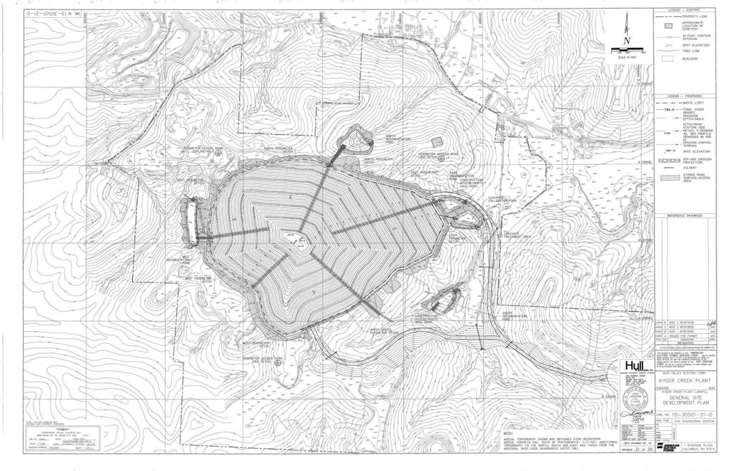
5 KYGER CREEK CCR LANDFILL RUN-ON AND RUN-OFF CONTROL SYSTEM PLAN Introduction 1.0 INTRODUCTION 1.1 OBJECTIVE On April 17, 2015 the Disposal of Coal Combustion Residuals (CCR) from Electric Utilities rule (Environmental Protection Agency, 2015) was published in the Federal Register. Stantec Consulting Services Inc. (Stantec) was contracted by the Ohio Valley Electric Corporation (OVEC) to document the existing run-on and run-off plan for the Kyger Creek Station s CCR Landfill and to evaluate compliance with of the EPA Final CCR Rule. 1.2 OUTLINE OF RULE REQUIREMENTS The objective of the review described herein is to evaluate compliance related to , specifically the following: (1) Run-on: The run-on control system must prevent flow onto the active portion of the Kyger Creek Station s CCR Landfill during the peak discharge from a 25- year, 24-hour storm event. (2) Run-off: The Kyger Creek Station s CCR Landfill run-off control system must collect and control at least the water volume resulting from a 25-year, 24-hour storm event. (3) Run-off (permitted discharge): Run-off point sources that discharge into waters of the United States must discharge through a permitted outfall, in this case the National Pollutant Discharge Elimination System (NPDES). 2.0 RUN-ON AND RUN-OFF CONTROL SYSTEM PLAN Stantec personnel reviewed three design documents as a basis for the Kyger Creek CCR Landfill s run-on and run-off control system plan: Class III Residual Waste Permit To Install Application. Ohio Valley Electric Corporation. Kyger Creek Plant Landfill. Gallia County, Cheshire, Ohio. Volume I of IV. (Hull & Associates, Inc., 2008a) Permit To Install Plans - Class III Residual Waste Facility. Ohio Valley Electric Corporation. Kyger Creek Plant Landfill. Cheshire, Ohio. (Hull & Associates, Inc., 2008b) Phase 1 Construction Plans - Class III Residual Waste Facility, Ohio Valley Electric Corporation. Kyger Creek Plant Landfill. Cheshire, Ohio. (Hull & Associates, Inc., 2009) jsh v:\1755\active\ \geotechnical\analysis\run-on run-off\stan - final review\rpt_kyger_ccr_runonrunoff_draft_ docx 1
6 KYGER CREEK CCR LANDFILL RUN-ON AND RUN-OFF CONTROL SYSTEM PLAN Summary of Findings 3.0 SUMMARY OF FINDINGS 3.1 RUN-ON AND RUN-OFF ANALYSIS The following text presents the review of the Kyger Creek Station Landfill run-on and run-off analysis as described in Hull & Associates, Inc. (2008a). Section (C)(6)(k) of the Permit to Install, Volume I, describes the surface drainage designed for the site s landfill as following: Surface water will be controlled by erosion control terraces, rock lined and geotextile reinforced letdowns, perimeter ditches (with permanent erosion control matting where necessary), and culverts, all of which ultimately flow to one of the four sedimentation ponds. Appendix G-I of the Permit to Install, Volume I, summarizes the surface water management design and effectively outlines the run-on and run-off control system plan. It also describes the design criteria associated with the surface drainage: The design methodologies and calculations contained in this section were developed to meet the requirements of the regulations for surface water control at a residual waste disposal facility contained within Ohio Administrative Code (OAC) The drainage design includes determination of: Drainage channel and culvert sizes, Sedimentation pond volumes, and Principal and emergency spillways sizes. A system of storm water run-on berms and run-off ditches control surface water. Run-on berms divert off-site run-on away from the landfill working area. Run-off ditches convey run-off from the disposal area. Run-on and run-off quantities are addressed by providing drainage control structures and channels capable of conveying discharge from a minimum of the 25-year, 24- hour storm event with an adequate freeboard. According to the Hull & Associates, Inc. (2008b): Clean water shall be diverted around the disposal area as much as feasible as shown on this drawing. If it is unable to be routed around the disposal area, then it shall be managed as leachate. Clean water shall be diverted around the sediment ponds when possible. When it is not feasible to divert the water around the sediment ponds, the water shall be managed through the ponds. Four sedimentation ponds, located to the north, south, east, and west of the landfill, are designed to provide a minimum storage of acre-feet per acre of the interim and/or final jsh v:\1755\active\ \geotechnical\analysis\run-on run-off\stan - final review\rpt_kyger_ccr_runonrunoff_draft_ docx 2
7 KYGER CREEK CCR LANDFILL RUN-ON AND RUN-OFF CONTROL SYSTEM PLAN Summary of Findings cover in the respective watersheds. Hull & Associates, Inc. (2008a) states that the actual storage volumes exceed acre-feet per acre. Each sedimentation pond receives the non-contact surface water run-off from portions of the CCR landfill that are capped or have intermediate cover. Hull & Associates, Inc. (2008a) describes the ponds principal/emergency spillways as having capacity to safely discharge the flow from the 100-year, 24-hour storm event. The ponds are intended to only manage non-contact surface water. Appendix G-I of Hull & Associates, Inc. (2008a) details the hydraulic and hydrologic portion of the engineering analysis for the Kyger Creek Station s Landfill Computation Methods Appendix G-I describes the computational methodology used for the drainage design. XP Software s Stormwater Management Model (XP-SWMM) was used to determine peak flow rates for all drainage areas, drainage channels and to establish the required sedimentation pond storage volumes. XP-SWMM is capable of simulating complex hydrology and hydraulic computations including infiltration, evaporation, runoff volume, storage volume, peak flows, hydrographs, backwater, surcharging, headloss, and performing other required analyses necessary for drainage design. The storage capacity of each of the four sedimentation ponds was determined using the output information from the Bentley PondPack software (PondPack). The maximum design water level elevation for each pond was established, and the designs of the principal/emergency spillways were determined to maintain a minimum of one foot of freeboard during the 100-year, 24-hour event. The culvert calculations were performed using the Haestad Methods CulvertMaster Software (CulvertMaster) to demonstrate that the culvert design are capable of managing the flow rate from a 25-year, 24-hour storm event Model Hydrology and Hydraulics For the run-on and run-off analysis, appropriate hydrologic modeling methodologies are briefly described in Appendix G-I and G-II (Hull & Associates, Inc. 2008a). A rainfall amount for the 25- year storm event (4.32 inches) was obtained from the Precipitation Frequency Atlas of the United States, NOAA Atlas 14 using a precipitation event duration of 24 hours. Modeling software developed by XP-SWMM was used for the design. XP-SWMM and the SCS hydrologic methodology were used to determine the 10-year, 25-year, and 100-year runoff volumes and peak flows. Appendix G-II of the Permit to Install application provides the Stormwater Management Model (SWMM) results. jsh v:\1755\active\ \geotechnical\analysis\run-on run-off\stan - final review\rpt_kyger_ccr_runonrunoff_draft_ docx 3
8 KYGER CREEK CCR LANDFILL RUN-ON AND RUN-OFF CONTROL SYSTEM PLAN Summary of Findings As part of the design, 67 hydrologic sub-watersheds were delineated so peak discharge values could be determined for channel and culvert designs. Run-off from the facility will be controlled by internal management practices and be diverted to four local sedimentation ponds. A map of the watershed drainage areas is included in Figure G-1 of Appendix G. According to Appendix G-I: The subcatchment areas are defined by the drainage divides, such as topography, terraces, ditches, and other site features. To model the subcatchment areas, the acreage, slope, surface roughness, infiltration rate, and other parameters were entered into the XP-SWMM model. The physical parameters of the subcatchments and drainage components were then input into the XP-SWMM model to calculate all of the stormwater runoff, volume, and peak flow rates for the drainage areas and collection system components. The hydraulic components of the model are described below: The components of the drainage systems include four main catchments (north, south, east, and west basins), erosion control terraces, letdowns, ditches/swales, culverts and sedimentation pond inlets. The physical parameters of the components describe the type, size, slope, length, height, width, elevation, roughness, and other physical properties for each of the drainage components. The drainage channels convey surface water runoff from the subcatchments into the sedimentation ponds. Each channel is designed to convey the 25-year, 24-hour storm event with a minimum freeboard of 0.5 feet at normal depth. The stormwater drainage culverts are designed to convey surface water runoff from the catchment areas and upstream drainage components to the sedimentation ponds. These surface control structures are designed to carry the peak flows calculated from the 25-year, 24-hour storm event in accordance with OAC Appendix G-II provides a summary of structures used to handle the discharges for the site. The design of the run-on control system involves berms around the perimeter of the landfill. The runoff control system from the Landfill are handled by a network of perimeter ditches that direct run-off towards one of four sedimentation ponds. Peak flows were calculated for the sizing of drainage features at the outfalls of the primary drainage ditches and critical sub-watersheds for sizing of the secondary ditches and diversion berms. Based on the XP-SWMM model results (Hull & Associates, Inc., 2008a), the drainage structures can safely convey both the 25-year and 100-year, 24-hour peak flows. Details on the drainage channels and rock letdown structures are provided on Sheet 47-D in the Permits to Install Plans, and modeling results are shown in Appendix G-II of the Permit to Install, Volume I. Details on the culverts are provided on Sheet 48-C in the Permit to Install Plans, and modeling results are shown in Appendix G-III of the Permit to Install, Volume I (Hull & Associates, Inc., 2008a, 2008b). jsh v:\1755\active\ \geotechnical\analysis\run-on run-off\stan - final review\rpt_kyger_ccr_runonrunoff_draft_ docx 4
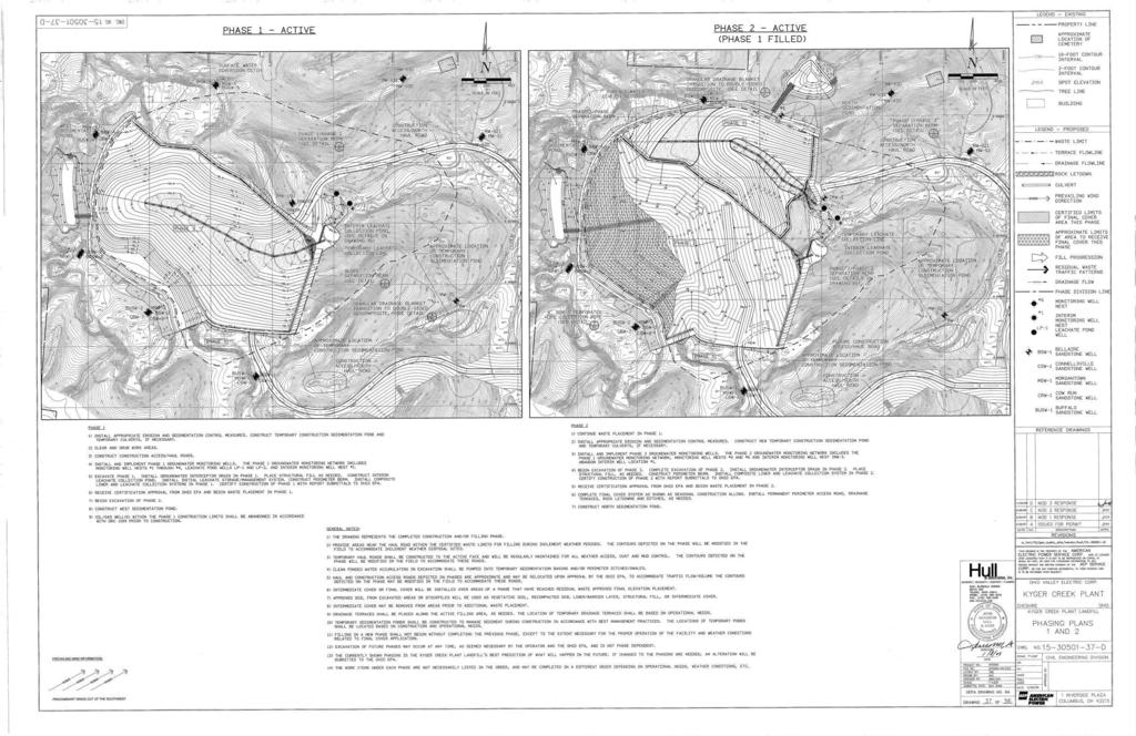
9 KYGER CREEK CCR LANDFILL RUN-ON AND RUN-OFF CONTROL SYSTEM PLAN Summary of Findings As part of the run-on and run-off control system plan, Stantec personnel also reviewed the results of the reservoir routing analyses. PondPack models were used to simulate the reservoir routing analyses. PondPack output files show the results of the storage, spillway, and embankment characteristics of the four ponds. The analyses indicate that the ponds are adequately sized and are capable of passing flows generated from the 100-year, 24-hour storm event maintaining freeboard without overtopping. Therefore, the ponds will be capable of routing the 25-year, 24- hour storm event required by 40 CFR (a). Details on the ponds are provided on Sheets 46-D and Sheets in the Permit to Install Plans, and modeling results are shown in Appendix G-IV through G-VII of the Permit to Install, Volume I (Hull & Associates, Inc., 2008a, 2008b). 3.2 RUN-ON AND RUN-OFF ANALYSIS - DISCHARGES Within Permit to Install application, Volume I, there is a section titled: OAC (C)(2) Variance and Exemption Requests. This sections states: A variance is being requested from the requirement in OAC (C)(4)(d)(iv) to install a liner under the four proposed sedimentation ponds at the Facility. The variance request is justified since the sedimentation ponds will manage only non-contact surface water run-off from areas of the Facility where final or intermediate cover has been installed. In addition, the sedimentation ponds will be constructed in low permeability shales and soils. Discharge from the ponds will be covered by the NPDES permit. The variance requested is further justified since Ohio EPA s municipal solid waste regulations do not require a liner system for sedimentation ponds with the same intended use of managing and controlling non-contact surface water run-off. Residual and exempt wastes are appropriately regulated less stringently that municipal solid waste since they pose much less of a potential threat to human health and the environment. Within the paragraph above, the variance request states the discharge from the ponds will be covered by the NPDES permit and addresses the discharge of storm water from the proposed facility boundary and, as a result, complies with 40 CFR (2)(b). OVEC s Kyger Creek Station maintains NPDES permit 0IB00005*PD. It s current expiration date is April 30, 2019 (OEPA, 2016). 3.3 CONSTRUCTION, OPERATION, AND MAINTENANCE Construction certification reports (PSI, 2010 and S&ME, 2013) document that the constructed CCR Landfill has been built in general accordance with the permit requirements. Hull & Associates, Inc. (2008b, 2009) plans for Phase 1 were compared to 2016 aerial imagery. The topography appears to reflect the design stormwater elements. Reference plans and figures are provided in Appendix A. jsh v:\1755\active\ \geotechnical\analysis\run-on run-off\stan - final review\rpt_kyger_ccr_runonrunoff_draft_ docx 5
10 KYGER CREEK CCR LANDFILL RUN-ON AND RUN-OFF CONTROL SYSTEM PLAN References Station personnel perform weekly and monthly inspections of the landfill to note maintenance and operational concerns. Annual landfill and CCR surface impoundment dam and dike inspections are performed and documented in the Operating Record (Stantec, 2016; AEPSC, 2015). Concerns noted in the inspections and any necessary operational or maintenance adjustments to address the concerns are part of the Operating Record. 3.4 MODIFICATIONS TO THE EXISTING CONTROL SYSTEM The existing run-on and run-off controls for Kyger Creek s CCR Landfill were designed and permitted in The design permitted is for the complete buildout of the landfill and its stormwater management system. As of this submittal, only Area 1 (Parts 1, 2, and 3) is constructed and accepting CCRs. No portion of the landfill is considered capped and closed by the state of Ohio. The watershed running onto the landfill area has not been subject to significant construction or land use modification. The state of practice relies on Bonnin et al (2016) (NOAA Atlas 14) for point precipitation frequency estimates. The precipitation estimate for the 24-hour, 25-year storm event is 4.30 inches with 90% confidence intervals. Hull & Associates, Inc. (2008a) modeled the 24-hour, 25- year storm event as 4.32 inches in the XP-SWMM model (Appendix G-II). The 25-year, 24-hour rainfall depth used in the design calculations was obtained from NOAA Atlas 14, which is consistent with current practice. The existing run-on and run-off control design meets current standards. 4.0 REFERENCES American Electric Power Service Corporation (AEPSC) (2015) Dam and Dike Inspection Report. GERS Kyger Creek Station. Gallipolis, Ohio. Geotechnical Engineering. November. Environmental Protection Agency (2015). Final Rule: Disposal of Coal Combustion Residuals from Electric Utilities. Federal Register, Vol. 80, No. 74, April 17. Hull & Associates, Inc. (2008a). Class III Residual Waste Permit To Install Application for the: Ohio Valley Electric Corporation Kyger Creek Plant Landfill Gallia County, Cheshire, Ohio. Volume I of IV. March 2007 (Revised May 2008) Hull & Associates, Inc. (2008b). Ohio Valley Electric Corporation Kyger Creek Plant Landfill Permit To Install Plans - Class III Residual Waste Facility, Cheshire, Ohio. Issued For Permit - February 2007 (Revised November 2008). jsh v:\1755\active\ \geotechnical\analysis\run-on run-off\stan - final review\rpt_kyger_ccr_runonrunoff_draft_ docx 6
11 KYGER CREEK CCR LANDFILL RUN-ON AND RUN-OFF CONTROL SYSTEM PLAN References Hull & Associates, Inc. (2009). Ohio Valley Electric Corporation Kyger Creek Plant Landfill Phase 1 Construction Plans - Class III Residual Waste Facility, Cheshire, Ohio. Issued For Construction, March. Bonnin, G.M., D. Martin, B. Lin, T. Parzybok, M. Yekta, and D. Riley (2016). NOAA Atlas 14. Point Precipitation Frequency Estimates. Volume 2, Version 3. Location name: Cheshire, Ohio, USA. Latitude: , Longitude: , Elevation: ft. Ohio Environmental Protection Agency (OEPA) (2016). List Individual NPDES Permit by County. Division of Surface Water. Gallia. Accessed October 6. Professional Service Industries, Inc. (PSI) (2010). Construction Certification Report. Area 1 Part 1. Kyger Creek Plant Landfill. November 30. PSI Report S&ME, Inc. (2013). Construction Certification Report. Area 1, Parts 2 and 3. Kyger Creek Plant. Residual Waste Landfill. January. Stantec Consulting Services Inc. (2016) CCR Rule Inspection, Kyger Creek Landfill. Kyger Creek Generating Station. Cheshire, Ohio. Gallia County. January. jsh v:\1755\active\ \geotechnical\analysis\run-on run-off\stan - final review\rpt_kyger_ccr_runonrunoff_draft_ docx 7
12 APPENDIX A REFERENCE PLANS AND FIGURES
13
14
15 ( $ $ V:\1755\active\ \gis\image\kyger.mxd Revised: By: apooler 35 Ohio West Virginia Notes 1. Coordinate System: NAD 1983 StatePlane Ohio South FIPS 3402 Feet 2. ESRI - NAIP 2015 Ortho-Imagery 3. Hull & Associates, Inc. (2008b). Ohio Valley Electric Corporation Kyger Creek Plant Landfill Permit To Install Plans - Class III Residual Waste Facility, Cheshire, Ohio. Issued For Permit - February 2007 (Revised November 2008) D PHASE2b(filled).dwg Feet 1:8,400 (At original document size of 8.5x11) Project Location Client/Project Kyger Creek Plant CCR Landfill Run-on and Run-off Control Plan Figure No. Title Cheshire Gallia County, OH Disc laime r: Stantec assume s no responsibility for data supplied in e lectronic format. The re cipie nt acc epts full responsibility for verifying the accuracy and comple teness of the data. The recipient releases Stante c, its of ficers, em ployees, c onsultants and age nts, from any and all claim s arising in any way from the c ontent or provision of the data. A-1 Plan View of CCR Landfill Prepared by AP on Technical Review by JH on Independent Review by SH on
16 ( $ $ V:\1755\active\ \gis\image\kyger.mxd Revised: By: apooler 35 Ohio West Virginia Notes 1. Coordinate System: NAD 1983 StatePlane Ohio South FIPS 3402 Feet 2. ESRI - NAIP 2015 Ortho-Imagery 3. Hull & Associates, Inc. (2008b). Ohio Valley Electric Corporation Kyger Creek Plant Landfill Permit To Install Plans - Class III Residual Waste Facility, Cheshire, Ohio. Issued For Permit - February 2007 (Revised November 2008) Feet 1:8,400 (At original document size of 8.5x11) Project Location Client/Project Kyger Creek Plant CCR Landfill Run-on and Run-off Control Plan Figure No. Title Cheshire Gallia County, OH Disc laime r: Stantec assume s no responsibility for data supplied in e lectronic format. The re cipie nt acc epts full responsibility for verifying the accuracy and comple teness of the data. The recipient releases Stante c, its of ficers, em ployees, c onsultants and age nts, from any and all claim s arising in any way from the c ontent or provision of the data. A-2 Plan View of CCR Landfill Prepared by AP on Technical Review by JH on Independent Review by SH on
INFLOW DESIGN FLOOD CONTROL SYSTEM PLAN PLANT BARRY ASH POND ALABAMA POWER COMPANY
 INFLOW DESIGN FLOOD CONTROL SYSTEM PLAN PLANT BARRY ASH POND ALABAMA POWER COMPANY Section 257.82 of EPA s regulations requires the owner or operator of an existing or new CCR surface impoundment or any
ENVIRONMENTAL ENGINEERING LAND SURVEYING
 ENVIRONMENTAL ENGINEERING LAND SURVEYING Inflow Design Flood Control System Plan Bottom Ash Pond Sherburne County Generating Plant Introduction This report presents documentation and certification of the
CLOSURE PLAN. CFR (b) Document No. GERS Stingy Run Flyash Pond. Gavin Plant Cheshire, Ohio. October, 2016
 Document No. GERS Stingy Run Flyash Pond. Gavin Plant Cheshire, Ohio. October, 2016") CLOSURE PLAN CFR 257.102(b) Stingy Run Flyash Pond Gavin Plant Cheshire, Ohio October, 2016 Prepared for: AEP Generation Resources Gavin Plant Cheshire, Ohio Prepared by: American Electric Power Service
CLOSURE PLAN CFR 257.102(b) Stingy Run Flyash Pond Gavin Plant Cheshire, Ohio October, 2016 Prepared for: AEP Generation Resources Gavin Plant Cheshire, Ohio Prepared by: American Electric Power Service
NEW CASTLE CONSERVATION DISTRICT. through. (Name of Municipality) PLAN REVIEW APPLICATION DRAINAGE, STORMWATER MANAGEMENT, EROSION & SEDIMENT CONTROL
 PLAN REVIEW APPLICATION DRAINAGE, STORMWATER MANAGEMENT, EROSION & SEDIMENT CONTROL") NEW CASTLE CONSERVATION DISTRICT through (Name of Municipality) PLAN REVIEW APPLICATION DRAINAGE, STORMWATER MANAGEMENT, EROSION & SEDIMENT CONTROL Office use only: Received by Municipality: Received by
NEW CASTLE CONSERVATION DISTRICT through (Name of Municipality) PLAN REVIEW APPLICATION DRAINAGE, STORMWATER MANAGEMENT, EROSION & SEDIMENT CONTROL Office use only: Received by Municipality: Received by
Project Drainage Report
 Design Manual Chapter 2 - Stormwater 2A - General Information 2A-4 Project Drainage Report A. Purpose The purpose of the project drainage report is to identify and propose specific solutions to stormwater
Inflow Design Flood Control System Plan
 Inflow Design Flood Control System Plan For Compliance with the Coal Combustion Residuals Rule (40 CFR Part 257) Valmont Station - CCR Surface Impoundments Public Service Company of Colorado Denver, Colorado
2015 ANNUAL ENGINEERING INSPECTION REPORT ENTERGY INDEPENDENCE PLANT CLASS 3N LANDFILL PERMIT NO S3N-R2 AFIN:
 2015 ANNUAL ENGINEERING INSPECTION REPORT ENTERGY INDEPENDENCE PLANT CLASS 3N LANDFILL PERMIT NO. 0200-S3N-R2 AFIN: 32-00042 JANUARY 15, 2016 ENTERGY INDEPENDENCE PLANT CLASS 3N LANDFILL 2015 ANNUAL ENGINEERING
2015 ANNUAL ENGINEERING INSPECTION REPORT ENTERGY WHITE BLUFF PLANT CLASS 3N LANDFILL PERMIT NO S3N-R3 AFIN:
 2015 ANNUAL ENGINEERING INSPECTION REPORT ENTERGY WHITE BLUFF PLANT CLASS 3N LANDFILL PERMIT NO. 0199-S3N-R3 AFIN: 35-00110 JANUARY 15, 2016 ENTERGY WHITE BLUFF PLANT CLASS 3N LANDFILL 2015 ANNUAL ENGINEERING
Understanding Stormwater Pollution Prevention Plans (SWPPPs) (SWPPPS)
 (SWPPPS)") Understanding Stormwater Pollution Prevention Plans (SWPPPs) (SWPPPS) Definitions SWPPP: Storm Water Pollution Prevention Plan BMP: Best Management Practice(s) to control pollution IDNR: Iowa Department
Understanding Stormwater Pollution Prevention Plans (SWPPPs) (SWPPPS) Definitions SWPPP: Storm Water Pollution Prevention Plan BMP: Best Management Practice(s) to control pollution IDNR: Iowa Department
Closure Plan Ash Disposal Area PGE Boardman Power Plant
 FIRST ISSUE REVISION 0 Closure Plan Ash Disposal Area PGE Boardman Power Plant Prepared for Portland General Electric September 2015 2020 SW 4th Avenue, Suite 300 Portland, Oregon 97201 This document was
SECTION 3 DRAINAGE. 3-1 General. 3-2 Drainage Ordinances and Legal Requirements
 SECTION 3 DRAINAGE 3-1 General All Drainage plans for proposed development shall be prepared by a Professional Engineer registered in Virginia, except as noted below. Further, their seal and signature
SECTION STORM DRAINAGE DESIGN, GRADING, AND WATER QUALITY TECHNICAL CRITERIA TABLE OF CONTENTS PAGE 402 STORM DRAINAGE DESIGN CRITERIA 400-1
 CITY OF THORNTON Standards and Specifications Revised: October 2012 SECTION 400 - STORM DRAINAGE DESIGN, GRADING, AND WATER QUALITY TECHNICAL CRITERIA TABLE OF CONTENTS PAGE 401 GENERAL PROVISIONS 400-1
2016 LANDFILL INSPECTION REPORT CARDINAL PLANT BRILLIANT, OHIO
 2016 LANDFILL INSPECTION REPORT GERS-16-004 CARDINAL PLANT BRILLIANT, OHIO PREPARED BY GEOTECHNICAL ENGINEERING AEP SERVICE CORPORATION 1 RIVERSIDE PLAZA COLUMBUS, OHIO Cardinal Plant Landfill Inspection
Chapter 6. Hydrology. 6.0 Introduction. 6.1 Design Rainfall
 6.0 Introduction This chapter summarizes methodology for determining rainfall and runoff information for the design of stormwater management facilities in the City. The methodology is based on the procedures
Erosion & Sedimentation Control Policy
 Issue Date 10/22/2010 Page 1 of 8 Erosion & Sedimentation Control Policy Introduction: Soil erosion is the removal of soil by water, wind, ice or gravity and sediment deposition occurs when the rate of
Run-On and Run-Off Control System Plan Neal North Energy Center Monofill
 Run-On and Run-Off Control System Plan Neal North Energy Center Monofill MidAmerican Energy Company, Neal North Energy Center Coal Combustion Residual Rule Compliance October 10, 2016 Run-On and Run-Off
Stormwater Local Design Manual For Houston County, Georgia
 Stormwater Local Design Manual For Houston County, Georgia Adopted November 15, 2005 TABLE OF CONTENTS 1. FORWARD... 1 2. GENERAL LEVEL OF SERVICE STANDARDS... 2 2.1. DETENTION REQUIREMENTS... 2 2.1.1.
Lyon Creek Cedar Way Stormwater Detention Dam Operation and Maintenance Manual
 Lyon Creek Cedar Way Stormwater Detention Dam Operation and Maintenance Manual Prepared by: Mike Shaw Stormwater Program Manager City of Mountlake Terrace January 2010 Section I General Information This
STORMWATER RUN-ON AND RUN-OFF CONTROL PLAN ENTERGY ARKANSAS, INC. INDEPENDENCE PLANT CLASS 3N CCR LANDFILL
 STORMWATER RUN-ON AND RUN-OFF CONTROL PLAN ENTERGY ARKANSAS, INC. INDEPENDENCE PLANT CLASS 3N CCR LANDFILL PERMIT NO. 0200-S3N-R2 AFIN: 32-00042 OCTOBER 12, 2016 STORMWATER RUN-ON AND RUN-OFF CONTROL PLAN
MODEL Stormwater Local Design Manual. City of Centerville
 MODEL Stormwater Local Design Manual City of Centerville Adopted December 6, 2005 TABLE OF CONTENTS 1. FORWARD... 1 2. GENERAL LEVEL OF SERVICE STANDARDS... 1 2.1. DETENTION REQUIREMENTS... 1 2.1.1. Discharge
David Miller, P.E.- Atlanta. The New Coal Ash Regulations Wednesday, May 6, 2015
 David Miller, P.E.- Atlanta The New Coal Ash Regulations Wednesday, May 6, 2015 Overview of CCR Management & Regulations Subtitle D Requirements & Compliance Schedule Non-Utility Boilers Beneficial Reuse
CCR LANDFILL RUN-ON AND RUN-OFF CONTROL SYSTEM PLAN. Pursuant to 40 CFR
 Run-On & Run-Off Control System Plan R.M. SCHAHFER GENERATING STATION CCR LANDFILL RUN-ON AND RUN-OFF CONTROL SYSTEM PLAN Wheatfield, Indiana Pursuant to 40 CFR 257.81 Submitted To: Northern Indiana Public
3.0 Planning and Submittal Requirements
 October 2003, Revised February 2005 Chapter 3.0, Planning and Submittal Requirements Page 1 3.0 Planning and Submittal Requirements 3.1 Drainage Studies and Drawings The City of Greenwood Village (Village)
Summary of Detention Pond Calculation Canyon Estates American Canyon, California
 July 15, 2015 Bellecci & Associates, Inc Summary of Detention Pond Calculation Canyon Estates American Canyon, California 1. Methodology: Method: Unit Hydrograph Software: Bentley Pond Pack Version 8i
Initial Closure Plan Slag Pond. Nelson Dewey Generating Station. Wisconsin Power and Light Company. Prepared for:
 Initial Closure Plan Slag Pond Prepared for: Wisconsin Power and Light Company 11999 County Highway VV Cassville, Wisconsin 53806 Prepared by: SCS ENGINEERS 2830 Dairy Drive Madison, Wisconsin 53718-6751
General Permit No.: OHR Page 53 of 146
 Page 53 of 146 Part 8 Sector-Specific Requirements for Industrial Activity Subpart J Sector J Non-Metallic Mineral Mining and Dressing. You shall comply with Part 8 sector-specific requirements associated
Applying landforming to reclamation: A case study in Central Appalachia
 Applying landforming to reclamation: A case study in Central Appalachia Leslie Hopkinson, John Quaranta April 12, 2017 Department of Civil and Environmental Engineering West Virginia University WEST VIRGINIA
Lansing Generating Station Project No Closure Plan for Existing CCR Revision: 1 TABLE OF CONTENTS
 Surface Impoundment Page No. i TABLE OF CONTENTS 1. INTRODUCTION... 1 2. PROPOSED CCR IMPOUNDMENT CLOSURE PROCEDURE... 2 3. PROPOSED COVER SYSTEM... 2 4. ESTIMATED MAXIMUM INVENTORY OF CCR... 3 5. ESTIMATED
POST CLOSURE PLAN. CFR (d) GERS Landfill. Pirkey Plant Hallsville, Texas. October, 2016
 GERS Landfill. Pirkey Plant Hallsville, Texas. October, 2016") POST CLOSURE PLAN CFR 257.104(d) Landfill Pirkey Plant Hallsville, Texas October, 2016 Prepared for : Southwest Electric Power Company Pirkey Power Plant Hallsville, Texas Prepared by: American Electric
POST CLOSURE PLAN CFR 257.104(d) Landfill Pirkey Plant Hallsville, Texas October, 2016 Prepared for : Southwest Electric Power Company Pirkey Power Plant Hallsville, Texas Prepared by: American Electric
Hydrologic and Hydraulic Analysis Report Mountaineer Plant Bottom Ash Pond Complex New Haven, West Virginia
 Hydrologic and Hydraulic Analysis Report Mountaineer Plant Bottom Ash Pond Complex New Haven, West Virginia September 2015 Terracon Project Number: N4155129 Prepared for: American Electric Power 1 Riverside
Watershed size and name: The drainage area is acres. The pond is located within the Ohio River watershed. (2016 Inflow Design Plan)
") A. B. Brown History of Construction 40 CFR 257.73 (c) (i.) (ii.) (iii.) Owner Name: Southern Indiana Gas and Electric Company dba Vectren Power Supply Owner Address: One Vectren Square, PO Box 209, Evansville,
A. B. Brown History of Construction 40 CFR 257.73 (c) (i.) (ii.) (iii.) Owner Name: Southern Indiana Gas and Electric Company dba Vectren Power Supply Owner Address: One Vectren Square, PO Box 209, Evansville,
Stormwater Management Manual. Public Works Department City of Billings, Montana
 Stormwater Management Manual Public Works Department City of Billings, Montana Stormwater Management Manual Developed by Public Works Department City of Billings, Montana With assistance from Debi Meling,
CLOSURE AND POST-CLOSURE CARE PLAN JAMES RIVER POWER STATION UTILITY WASTE LANDFILL CITY UTILITIES OF SPRINGFIELD, MISSOURI
 CLOSURE AND POST-CLOSURE CARE PLAN JAMES RIVER POWER STATION UTILITY WASTE LANDFILL CITY UTILITIES OF SPRINGFIELD, MISSOURI INITIAL PREPARATION DATE: October 11, 2016 TABLE OF CONTENTS 1. CERTIFICATION
Richland County Department of Public Works Engineering (Land Development) Division
 Division") Richland County Department of Public Works Engineering (Land Development) Division Commercial Projects What is a Commercial Project? Projects that are not related to residential single family homes and/or
Richland County Department of Public Works Engineering (Land Development) Division Commercial Projects What is a Commercial Project? Projects that are not related to residential single family homes and/or
SMART GYPSUM STACK MANAGEMENT FROM CONCEPT TO REALITY
 SMART GYPSUM STACK MANAGEMENT FROM CONCEPT TO REALITY Phong Vo, Manager - Engineering/Gypsum, Mosaic Fertilizer, LLC. 13830 Circa Crossing Drive Lithia, Florida 33547, USA and Ashraf H. Riad, Ph.D., P.E.,
ARTICLE V: STORMWATER MANAGEMENT AND DRAINAGE SYSTEMS
 ARTICLE V: STORMWATER MANAGEMENT AND DRAINAGE SYSTEMS Section 501: Purpose An adequate drainage system including necessary ditches, pipes, culverts, drains, inlets, bridges, detention ponds, etc. shall
SECTION EROSION AND SEDIMENTATION CONTROLS
 SECTION 312500 EROSION AND SEDIMENTATION CONTROLS PART 1 - GENERAL 1.01 GENERAL PROVISIONS A. Attention is directed to the CONTRACT AND GENERAL CONDITIONS and all Sections within DIVISION 01 - GENERAL
Gwinnett County Stormwater System Assessment Program
 Gwinnett County Stormwater System Assessment Program Jonathan Semerjian, PE Dept. of Water Resources Stormwater Management Sam Fleming, PE Dewberry Presentation Overview Project Background Drivers Enhanced
TEMPORARY SEDIMENT TRAP CODE
 ILLINOIS URBAN MANUAL PRACTICE STANDARD TEMPORARY SEDIMENT TRAP CODE 960 Source: DEFINITION A small temporary stormwater storage structure designed to trap sediment. PURPOSE The purpose of this practice
LANDFILL CLOSURE PLAN ENTERGY ARKANSAS, INC. INDEPENDENCE PLANT CLASS 3N CCR LANDFILL PERMIT NO S3N-R2 AFIN
 LANDFILL CLOSURE PLAN ENTERGY ARKANSAS, INC. INDEPENDENCE PLANT CLASS 3N CCR LANDFILL PERMIT NO. 0200-S3N-R2 AFIN 32-00042 OCTOBER 12, 2016 LANDFILL CLOSURE PLAN ENTERGY ARKANSAS, INC. INDEPENDENCE PLANT
FIRM NAME DESIGNER: CHECKER: DATE: FPID #: DESCRIPTION: COUNTY: DRAINAGE DESIGN CHECKLIST. Designers Initials. Checkers Initials.
 I. Drainage Report A. Executive Summary - Brief Overview of Project Drainage Design B. Project Description 1. Existing Conditions 2. Proposed Project Conditions 3. Project Justification Narrative - Basin
STORMWATER RUNOFF AND WATER QUALITY IMPACT REVIEW
 SUBCHAPTER 8 STORMWATER RUNOFF AND WATER QUALITY IMPACT REVIEW 7:45-8.1 Purpose and scope of review Except for those projects expressly exempted by this chapter or waived by the Commission, the Commission
SECTION 4 SURFACE WATER MANAGEMENT DESIGN AND CONSTRUCTION REQUIREMENTS
 SECTION 4 SURFACE WATER MANAGEMENT DESIGN AND CONSTRUCTION REQUIREMENTS Page 4-1 INTRODUCTION 4-3 4-1.01 Applicability of VMCs 14.24, 14.25, 14.26 4-4 4-1.02 Minimum Requirements - Projects Below Threshold
Closure Plan Brame Fly Ash Pond
 Brame Fly Ash Pond CLECO Corporation Rodemacher Unit 2 Project No. 90965 Revision 0 10/14/2016 Brame Fly Ash Pond prepared for CLECO Corporation Rodemacher Unit 2 Rapides Parish, Louisiana Project No.
CHAPTER 8 EROSION AND SEDIMENT CONTROL PLAN REQUIREMENTS
 CHAPTER 8 EROSION AND SEDIMENT CONTROL PLAN REQUIREMENTS 8.1 INTRODUCTION To minimize the detrimental effects of erosion and sedimentation, Henrico County requires that those individuals responsible for
HAZARD POTENTIAL CLASSIFICATION REPORT
 HAZARD POTENTIAL CLASSIFICATION REPORT PONDS 1 & 2, JR WHITING PLANT ERIE, MICHIGAN OCTOBER 13, 2016 PREPARED FOR: CONSUMERS ENERGY COMPANY TABLE OF CONTENTS SECTION: PAGE NO.: Certification... i 1.0 Introduction...
Coal Combustion Facility Assessment Report. October 20, 2010
 Coal Combustion Facility Assessment Report October 20, 2010 Introduction Stantec Consulting Services Inc. North American Consulting Firm 10,000 Engineers, Geologists, Architects, Scientists and Technicians
COON CREEK WATERSHED DISTRICT PERMIT REVIEW. Spring Lake Park Schools Westwood Middle School st Avenue NE, Spring Lake Park, MN 55432
 PAN 16-112, Westwood Middle School, Page 1 of 6 COON CREEK WATERSHED DISTRICT PERMIT REVIEW MEETING DATE: August 22, 2016 AGENDA NUMBER: 10 FILE NUMBER: 16-112 ITEM: Westwood Middle School RECOMMENDATION:
City of Tulsa. Stormwater Design Criteria Manual
 City of Tulsa Stormwater Design Criteria Manual 2014 Table of Contents Chapter 100 EXECUTIVE SUMMARY... 101 101 INTRODUCTION... 101 101.1 Manual Organization... 101 101.2 Manual Contents... 101 101.2.1
901 STORMWATER POLLUTION MANAGEMENT SECTION 901 STORMWATER POLLUTION MANAGEMENT
 SECTION 901 STORMWATER POLLUTION MANAGEMENT 901.1 DESCRIPTION Design, implement, inspect and maintain appropriate best management practices to minimize or eliminate erosion, sediment and other pollutants
INITIAL INSPECTION REPORT ASH LANDFILL AREA SPRINGERVILLE GENERATING STATION SPRINGERVILLE, ARIZONA
 INITIAL INSPECTION REPORT ASH LANDFILL AREA SPRINGERVILLE GENERATING STATION SPRINGERVILLE, ARIZONA Prepared for Tucson Electric Power Company January 19, 2016 Prepared by AMTECH Associates, L.L.C. 8666
Municipal Stormwater Ordinances Summary Table
 APPENDIX F Municipal Ordinances Summary Table Municipality Abington Bryn Athyn Borough Hatboro Borough Ordinance, SALDO Runoff equals pre post Erosion Sediment Control Water Quality Requirements Any which
DESIGN BULLETIN #16/2003 (Revised July 2007) Drainage Guidelines for Highways Under Provincial Jurisdiction in Urban Areas.
 Drainage Guidelines for Highways Under Provincial Jurisdiction in Urban Areas.") Drainage Guidelines for Highways Under Provincial Jurisdiction in Urban Areas. July 2007 Update to Design Bulletin #16/2003: Added under Design Criteria Culverts of 600mm diameter are commonly used to
Drainage Guidelines for Highways Under Provincial Jurisdiction in Urban Areas. July 2007 Update to Design Bulletin #16/2003: Added under Design Criteria Culverts of 600mm diameter are commonly used to
STORM WATER MANAGEMENT REPORT
 Silvercreek Junction STORM WATER MANAGEMENT REPORT Howitt Creek at the Silvercreek Parkway Site Guelph, Ontario August, 2008 TSH File 22304A-04 August 19, 2008 STORMWATER MANAGEMENT REPORT Howitt Creek
CITY UTILITIES DESIGN STANDARDS MANUAL
 CITY UTILITIES DESIGN STANDARDS MANUAL () September 2017 Page Chapter 1 Acronyms and Definitions 1.01 Purpose 1 1.02 Acronyms 1 1.03 Definitions 3 Chapter 2 Introduction 2.01 Purpose 1 2.02 Applicability
Mr. Michael Malone CPS Energy 145 Navarro Street San Antonio, Texas Project No
 Environmental Resources Management January 13, 2017 Mr. Michael Malone 145 Navarro Street San Antonio, Texas 78205 Project No. 0352436 CityCentre Four 840 West Sam Houston Parkway North, Suite 600 Houston,
SBSA. DATE: 31 May 2016 HILL AIR FORCE BASE CEN/CEIE PLAN REVIEW CHECKLIST FOR NEW DEVELOPMENT AND REDEVELOPMENT CONSTRUCTION
 SBSA PROJECT TITLE: KRSM095002, wo54127 Construct Clubhouse near Bldg 720; KRSM150043, wo54127 Replace Piping Utilities near Bldg 720, KRSM130012, wo54127 Demo Golf Clubhouse Bldg 720. General: DATE: 31
Ottumwa Generating Station Project No Closure Plan for Existing CCR Revision: 0 Surface Impoundments TABLE OF CONTENTS
 Surface Impoundments Page No. i TABLE OF CONTENTS 1. INTRODUCTION... 1 2. PROPOSED CCR IMPOUNDMENTS CLOSURE PROCEDURE... 3 3. PROPOSED COVER SYSTEM... 4 4. ESTIMATED MAXIMUM INVENTORY OF CCR... 4 5. ESTIMATED
FLORENCE COUNTY STORMWATER DESIGN MANUAL
 FLORENCE COUNTY STORMWATER DESIGN MANUAL JULY 18, 2013 Resolution No. 02-2013/14 Florence County Council TABLE OF CONTENTS TITLE PAGE NO. SECTION 1. GENERAL 1.1 INTRODUCTION--------------------------------------------------------------------------
Table of Contents. Attachments Attachment A Photos Attachment B Inspection Map. Pages 3 of 10
 Table of Contents 1.0 Introduction...4 2.0 Description of Landfill...4 3.0 Review of Available Information...5 4.0 Inspection...5 4.1 Changes in Geometry since Last Inspection...5 4.2 Volume...5 4.3 Definitions
E. STORMWATER MANAGEMENT
 E. STORMWATER MANAGEMENT 1. Existing Conditions The Project Site is located within the Lower Hudson Watershed. According to the New York State Department of Environmental Conservation (NYSDEC), Lower Hudson
901 - TEMPORARY EROSION AND POLLUTION CONTROL SECTION 901 TEMPORARY EROSION AND POLLUTION CONTROL
 SECTION 901 TEMPORARY EROSION AND POLLUTION CONTROL 901.1 DESCRIPTION Install, maintain and remove temporary erosion and pollution control devices as required during the construction of the project. BID
CHESAPEAKE BAY TMDL ACTION PLAN ( MS4 General Permit)
") CHESAPEAKE BAY TMDL ACTION PLAN (2013 2018 MS4 General Permit) Central Virginia Community College A Plan for Achieving a 5% Reduction of Existing Loads June 30, 2015 Main Campus This plan satisfies the
CHESAPEAKE BAY TMDL ACTION PLAN (2013 2018 MS4 General Permit) Central Virginia Community College A Plan for Achieving a 5% Reduction of Existing Loads June 30, 2015 Main Campus This plan satisfies the
INITIAL RUN-ON AND RUN-OFF CONTROLS PLAN NORTH VALMY GENERATING STATION (ASH LANDFILL) HUMBOLDT COUNTY, NEVADA OCTOBER 2016 PROJECT NO
 HUMBOLDT COUNTY, NEVADA OCTOBER 2016 PROJECT NO") INITIAL RUN-ON AND RUN-OFF CONTROLS PLAN NORTH VALMY GENERATING STATION (ASH LANDFILL) HUMBOLDT COUNTY, NEVADA OCTOBER 2016 PROJECT NO. 2016.R009 SUBMITTED TO: NV Energy, Inc. 6226 W. Sahara Ave. M/S 30
INITIAL RUN-ON AND RUN-OFF CONTROLS PLAN NORTH VALMY GENERATING STATION (ASH LANDFILL) HUMBOLDT COUNTY, NEVADA OCTOBER 2016 PROJECT NO. 2016.R009 SUBMITTED TO: NV Energy, Inc. 6226 W. Sahara Ave. M/S 30
Engineering Hydrology Class 3
 Engineering Hydrology Class 3 Topics and Goals: I.Develop s (estimate precipitation) II.Develop simple constant intensity design storm III.Develop SCS design storm Ocean s Why do we want to derive the?
110 STORMWATER MANAGEMENT AND COLLECTION SYSTEMS
 110 STORMWATER MANAGEMENT AND COLLECTION SYSTEMS 110.01 DEFINITIONS 110.01.01 Detention structure. A permanent structure for the temporary storage of stormwater runoff that is designed so as not to create
Preliminary Drainage Analysis
 Preliminary Drainage Analysis Tanimura and Antle Employee Housing Town of Spreckels County of Monterey, California LIB150205 May 29, 2015 Prepared For: Tanimura and Antle Produce Prepared By: 9699 Blue
TECHNICAL CONTENT PROPOSED STEEP SLOPE REGULATION
 1 TECHNICAL CONTENT PROPOSED STEEP SLOPE REGULATION Draft 2/08/10 (Revised 02-14-11,Revised 02-21-11, Revised 03-03-11, Revised 04-19-11, Revised 04-20-11, Revised 05-05-11, Revised 05-09-11). DEFINITIONS
CLIENT INFORMATION SITE INFORMATION
 Form COMMONWEALTH OF PENNSYLVANIA DEPARTMENT OF ENVIRONMENTAL PROTECTION GENERAL INFORMATION FORM AUTHORIZATION APPLICATION Before completing this General Information Form (GIF), read the step-by-step
iswm TM Criteria Manual City of Azle Section 14 City of Azle Subdivision Ordinance DRAFT-June Chapter 1
 City of Azle Section 14 City of Azle Subdivision Ordinance DRAFT-June 2010... Chapter 1 i CITY OF AZLE iswm CRITERIA MANUAL FOR SITE DEVELOPMENT AND CONSTRUCTION Incorporating the Regional NCTCOG Integrated
Inflow Design Flood Control System Plan
 Inflow Design Flood Control System Plan R.M. SCHAHFER GENERATING STATION CCR SURFACE IMPOUNDMENT INFLOW DESIGN FLOOD CONTROL SYSTEM PLAN Wheatfield, Indiana Pursuant to 40 CFR 257.82 Submitted To: Northern
Chatham Park Stormwater Manual
 Chatham Park Stormwater Manual Table of Contents A. Introduction... 2 B. Calculation Methods... 2 C. BMP Design Standards... 3 D. Compliance Points... 3 E. Critical Environmental Resources... 3 F. Submittal
CHESAPEAKE BAY TMDL ACTION PLAN ( MS4 General Permit)
") CHESAPEAKE BAY TMDL ACTION PLAN (2013 2018 MS4 General Permit) Piedmont Virginia Community College A Plan for Achieving a 5% Reduction of Existing Loads June 30, 2015 Main Campus This plan satisfies the
CHESAPEAKE BAY TMDL ACTION PLAN (2013 2018 MS4 General Permit) Piedmont Virginia Community College A Plan for Achieving a 5% Reduction of Existing Loads June 30, 2015 Main Campus This plan satisfies the
16.0 Water Quality Management Criteria for Developed Land
 October 2003, Revised February 2005 Criteria for Developed Land Page 1 16.1 Introduction 16.0 Water Quality Management Criteria for Developed Land Stormwater quality control is an integral part of any
City of Morristown. Stormwater Program Standard Operating Procedures. Stormwater Design Guidance Manual. April 1, 2016.
 City of Morristown Stormwater Program Standard Operating Procedures Stormwater Design Guidance Manual April 1, 2016 -Prepared By- City of Morristown 100 West First North Street Morristown, TN 37814 (423)
Fort Leonard Wood, Missouri. September 2013
 Fort Leonard Wood, Missouri September 2013 1 Presenters Shannon Kelly, Physical Scientist Clean Water Act Program Manager Directorate of Public Works Environmental Division Environmental Compliance Branch
ALABAMA S BEST MANAGEMENT PRACTICES. Protection of Water Quality During Timber Harvesting
 ALABAMA S BEST MANAGEMENT PRACTICES Protection of Water Quality During Timber Harvesting Water Quality Responsibility Landowners and/or involved professional forestry practitioners such as: Forest resource
Location Drainage Study
 Location Drainage Study PROJECT ROUTE: LIMITS: MUNICIPALITY/COUNTY: JOB NUMBER: IL 47 at Burlington Road 750ft NW to 750ft SE of IL 47(Burlington), & 1000ft S to 1000ft N of Burlington (IL47) Kane County
WELCOME TO THE CONSTRUCTION STORMWATER PERMIT WEBINAR
 WELCOME TO THE CONSTRUCTION STORMWATER PERMIT WEBINAR All the documents shown today are in the MN Stormwater Manual on the page titled 2018 Construction Stormwater Permit Public Notice and Public Informational
PART 3 - STANDARDS FOR SEWERAGE FACILITIES DESIGN OF STORM SEWERS
 PART 3 - STANDARDS FOR SEWERAGE FACILITIES 3.3 - DESIGN OF STORM SEWERS 3.301 Design of Storm Sewers A. General Information B. Investigations and Surveys C. Special Projects 3.302 Design Criteria for Storm
CITY OF REDLANDS MASTER PLAN OF DRAINAGE San Bernardino County, California
 CITY OF REDLANDS MASTER PLAN OF DRAINAGE San Bernardino County, California Prepared for City of Redlands 35 Cajon Street Redlands, California 92373 Prepared by 14725 Alton Parkway Irvine, CA 92618 Contact
Porous Pavement Flow Paths
 POROUS PAVEMENT MODELING Clear Creek Solutions, Inc., 2010 Porous pavement includes porous asphalt or concrete and grid/lattice systems (nonconcrete) and paving blocks. The use of any of these types of
CHAPTER 2 STORMWATER MANAGEMENT
 CHAPTER 2 STORMWATER MANAGEMENT REVISED SEPTEMBER 11, 2002 WHATCOM COUNTY DEVELOPMENT STANDARDS CHAPTER 2 - STORMWATER MANAGEMENT TABLE OF CONTENTS PART 1: ADMINISTRATIVE PROVISIONS Section 201. Regulatory
Chapter 7. Street Drainage. 7.0 Introduction. 7.1 Function of Streets in the Drainage System. 7.2 Street Classification
 7. Introduction This chapter summarizes methods to evaluate runoff conveyance in various street cross sections and curb types in the Town of Castle Rock and identifies acceptable upper limits of street
EFFECT OF UPSTREAM DEVELOPMENT ON THE CLEAR CREEK AREA
 EFFECT OF UPSTREAM DEVELOPMENT ON THE CLEAR CREEK AREA Technical Memorandum Farming in the Floodplain Project Prepared for May 2017 PCC Farmland Trust Photo credit: Google Earth TABLE OF CONTENTS Page
Application for Gas Exploration and Production
 1800 Washington Blvd. Suite 655 Baltimore Maryland 21230 Application for Gas Exploration and Production This application is to be used to obtain a permit to Drill and Operate a well, within the State for
CLARK COUNTY REGIONAL FLOOD CONTROL DISTRICT HYDROLOGIC CRITERIA AND DRAINAGE DESIGN MANUAL SECTION 200 DRAINAGE PLANNING AND SUBMITTAL
 CLARK COUNTY REGIONAL FLOOD CONTROL DISTRICT HYDROLOGIC CRITERIA AND DRAINAGE DESIGN MANUAL SECTION 200 DRAINAGE PLANNING AND SUBMITTAL TABLE OF CONTENTS 201 SUBMITTAL AND REVIEW PROCESS 201 202 DRAINAGE
VIRGINIA POLLUTION ABATEMENT (VPA) PERMIT APPLICATION. FORM B - ANIMAL FEEDING OPERATIONS (AFOs)
 PERMIT APPLICATION. FORM B - ANIMAL FEEDING OPERATIONS (AFOs)") VIRGINIA POLLUTION ABATEMENT (VPA) PERMIT APPLICATION FORM B - ANIMAL FEEDING OPERATIONS (AFOs) Department of Environmental Quality Rev. 02-2013 VIRGINIA POLLUTION ABATEMENT (VPA) PERMIT APPLICATION FORM
VIRGINIA POLLUTION ABATEMENT (VPA) PERMIT APPLICATION FORM B - ANIMAL FEEDING OPERATIONS (AFOs) Department of Environmental Quality Rev. 02-2013 VIRGINIA POLLUTION ABATEMENT (VPA) PERMIT APPLICATION FORM
Ingham County Drain Commissioner Patrick E. Lindemann 707 BUHL AVENUE P. O. BOX 220 MASON MI PH. (517) FAX (517)
 FAX (517)") Date Issued Ingham County Drain Commissioner Patrick E. Lindemann 707 BUHL AVENUE P. O. BOX 220 MASON MI 48854 PH. (517) 676-8395 FAX (517) 676-8364 APPLICATION FOR SOIL EROSION AND SEDIMENTATION POLLUTION
Date Issued Ingham County Drain Commissioner Patrick E. Lindemann 707 BUHL AVENUE P. O. BOX 220 MASON MI 48854 PH. (517) 676-8395 FAX (517) 676-8364 APPLICATION FOR SOIL EROSION AND SEDIMENTATION POLLUTION
Constructed Wetland Pond T-8
 Constructed Wetland Pond T-8 Description A constructed wetlands pond is a shallow retention pond designed to permit the growth of wetland plants such as rushes, willows, and cattails. Constructed wetlands
LOUISIANA URBAN STORMWATER COALITION. EXECUTING A SWPPP DURING CONSTRUCTION Presented by: Diane T. Baum
 LOUISIANA URBAN STORMWATER COALITION EXECUTING A SWPPP DURING CONSTRUCTION Presented by: Diane T. Baum SWPPP NOTIFICATION SIGN Post sign at entrance of site or areas where the public can easily access.
CCR Annual Inspection (b) for the Ash Pond at the San Miguel Plant. Revision 0
 for the Ash Pond at the San Miguel Plant. Revision 0") Submitted to San Miguel Electric Cooperative, Inc. 6200 FM 3387 Christine, Texas 78012 Submitted by AECOM 9400 Amberglen Boulevard Austin, Texas 78729 257.83 (b) for the Ash Pond at the San Miguel Plant
Submitted to San Miguel Electric Cooperative, Inc. 6200 FM 3387 Christine, Texas 78012 Submitted by AECOM 9400 Amberglen Boulevard Austin, Texas 78729 257.83 (b) for the Ash Pond at the San Miguel Plant
DRAINAGE DESIGN DOCUMENTATION
 June, 2017 DRAINAGE DESIGN DOCUMENTATION (An expansion of the Stormwater Management Design Report) Note: This report outline is not all-inclusive. There may be situations when information not included
CCR Certification: Initial Structural Stability Assessment (d)
") Submitted to Southern Indiana Gas & Electric Company dba Vectren Power Supply, Inc. (SIGECO) One Vectren Square Evansville, IN 47708 Submitted by AECOM 9400 Amberglen Boulevard Austin, Texas 78729 CCR
Submitted to Southern Indiana Gas & Electric Company dba Vectren Power Supply, Inc. (SIGECO) One Vectren Square Evansville, IN 47708 Submitted by AECOM 9400 Amberglen Boulevard Austin, Texas 78729 CCR
ENVIRONMENTAL RESOURCE PERMIT APPLICANT S HANDBOOK VOLUME II (Design and Performance Standards Including Basin Design and Criteria)
") ENVIRONMENTAL RESOURCE PERMIT APPLICANT S HANDBOOK VOLUME II (Design and Performance Standards Including Basin Design and Criteria) FLORIDA DEPARTMENT OF ENVIRONMENTAL PROTECTION Volume II (including Appendices
ENVIRONMENTAL RESOURCE PERMIT APPLICANT S HANDBOOK VOLUME II (Design and Performance Standards Including Basin Design and Criteria) FLORIDA DEPARTMENT OF ENVIRONMENTAL PROTECTION Volume II (including Appendices
Stormwater Quality Extended Detention Basin Operation and Maintenance (O&M) Manual. for: Located at: Prepared for: Prepared by:
 Manual. for: Located at: Prepared for: Prepared by:") Stormwater Quality Extended Detention Basin Operation and Maintenance (O&M) Manual for: Insert Development Name Located at: Insert Address Prepared for: Insert Property Owner Name, Address, and Phone Number
Stormwater Quality Extended Detention Basin Operation and Maintenance (O&M) Manual for: Insert Development Name Located at: Insert Address Prepared for: Insert Property Owner Name, Address, and Phone Number
Article 20: Erosion Control and Stormwater Management
 Article 20: Erosion Control and Stormwater Management Section 360: Purpose, Scope of Authority, Performance Guarantee and Approvals A. Purpose. The purpose of this document is to set forth minimum requirements
NAUGHTON POWER PLANT NORTH ASH POND INITIAL CLOSURE PLAN
 NAUGHTON POWER PLANT NORTH ASH POND INITIAL CLOSURE PLAN Prepared for: PacifiCorp Energy Project Manager: Chad Tomlinson Date: 01 September 2016 Document No.: NP-TR-022 Quality Assurance Statement Office
LAWRENCE, KANSAS STORMWATER MANAGEMENT CRITERIA
 LAWRENCE, KANSAS STORMWATER MANAGEMENT CRITERIA FEBRUARY 1996 CITY OF LAWRENCE, KANSAS STORMWATER MANAGEMENT CRITERIA TABLE OF CONTENTS Pg 1.0 GENERAL 1.1 Introduction... 1 1.2 Applicability... 1 1.3 General
APPENDIX H Guidance for Preparing/Reviewing CEQA Initial Studies and Environmental Impact Reports
 APPENDIX H H.1 Guidance for Preparing and Reviewing CEQA Initial Studies Step 1: Consider the Project Characteristics as Provided by the Project Applicant Review the project application and draft plan