A Conservation Catalog. Practices for Conserving Pennsylvania s Natural Resources
|
|
|
- Lynette Thomas
- 5 years ago
- Views:
Transcription


1 A Conservation Catalog Practices for Conserving Pennsylvania s Natural Resources
2

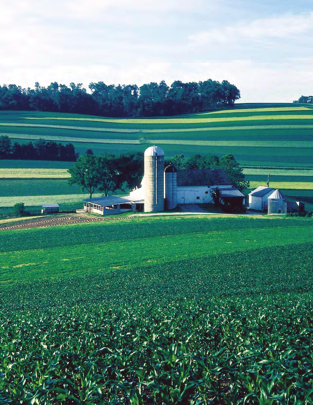
3 Introduction Pennsylvania is a land of great natural resources and Pennsylvania s farmers have always worked as stewards of the land to improve and protect those resources. The Pennsylvania Conservation Catalog is a cooperative effort of the Pennsylvania Conservation Partnership which supports farmers in those efforts. The Catalog identifies practices that may assist you in caring for the land while maintaining your economic viability and protecting farming as a way of life. Conservation practices and other best management practices may help you to meet a variety of conservation objectives such as preserving farmland for future generations; restoring and sustaining the productivity of your land; increasing wildlife; adapting to floods, droughts, and other climatic changes; and/or complying with federal, state, and regulatory requirements. While this Catalog is meant to help you plan for your land, additional assistance is also available. Local county conservation districts and the USDA s Natural Resources Conservation Service (NRCS) provide one on one technical assistance. Federal and state agencies such as the USDA s Farm Service Agency (FSA), Penn State Cooperative Extension, Pennsylvania Department of Environmental Protection (DEP), Pennsylvania Department of Agriculture (PDA), Pennsylvania State Conservation Commission (SCC), and Pennsylvania Department of Conservation and Natural Resources (DCNR) also provide information and are available to help or have financial programs to assist in the implementation of practices. Private consultants are another source to help you plan what s best for you. Some conservation efforts may require specific permits. Ask your conservation professional where to go for permit information. Conservation practices help restore and sustain land productivity, as well as preserve farmland for future generations. A Conservation Catalog 1

4 About This Catalog The Pennsylvania Conservation Catalog describes conservation practices and other best management practices to reduce soil erosion and sediment and nutrient loading to water resources. The Catalog also describes conservation practices that provide other benefits to soil, water, air, plant, animal, and energy resources. It explains how each practice works, gives tips on installing and managing practices, and suggests how practices may be combined to form a conservation system. Sediment and nutrients are the most common pollutants of our surface waters. Improving soil health and controlling sheet and gully erosion on all land are the first steps in improving water quality and so are found at the beginning of this publication. To further reduce sediment and nutrient loading, additional supporting practices are found next. Finally, practices for other conservation objectives are presented in the latter portion of the Catalog. Why Plan for the Whole Farm? By addressing all of the concerns on your farm together, you are selecting practices that compliment one another, ensuring that one practice does not cancel the benefits of or conflict with another and that they all work together for the greater good of the land. These selected practices should be scheduled in your conservation plan for future installation. Your conservation plan is also a useful record to document practices already installed that continue to be operated and maintained. State environmental regulations require farmers to assess all of their plowed and tilled crop fields as well as their barnyards and feedlots to ensure that soil erosion from these areas is minimized and eroding soils are kept from polluting nearby streams and other water bodies. Practices necessary to control this erosion and sedimentation are required to be listed in a plan referred to as an Agricultural Erosion and Sedimentation Control Plan. NRCS and Conservation District employees will help you develop a conservation plan and determine which conservation practices are best for you and will meet environmental regulations. Likewise, farmers are required by state regulation to manage their manure in such a way as to protect water, while meeting the nutrient needs of their crops. Farmers generating or using manure are obligated to develop and follow a written manure management plan or a nutrient management plan meeting state requirements. These plans, retained on the farm, outline manure and fertilizer application rates for the various crop fields where manure is applied, and also various other conservation practices as described in this manual. Practices such as animal heavy use area protection, cover cropping, buffers, and grazing management minimize nutrient loss to nearby or regional waters. Watershed Planning Just as you are planning for your entire farm, many communities and cities are planning for entire watersheds. Check with your local conservation district to see if watershed planning is taking place in your area. Watershed planning is everyone working together for the good of the resources. It means remembering, We all live downstream. Sometimes groups of farmers work together to 2 A Conservation Catalog

5 improve a length of stream in a watershed. In larger watersheds, townships and cities work together to improve the resources. Additional financial assistance funds may be available to help you install your conservation practices and other best management practices. Watershed planning is most often completed by local people determining and prioritizing the issues, and deciding what works best for them. Agriculture, industry, and residents all benefit from watershed planning. Finally, there are many economic and ecological opportunities on adjacent lands that can be integrated into the farm operation. Managing plant and animal communities on field borders and forest edges, open grasslands and herbaceous fields returning to woody cover, wetlands, and large forest tracts provide additional water quality improvements, better fish and wildlife habitat, good neighbor relations, diverse sources of income, and a legacy of stewardship to inspire future generations. How To Get Started Establish personal goals and objectives for your farm operation. Look at where you are now and think about where you want to be. Talk to family members and consider the future. You may want to talk to neighbors to determine if you share similar concerns. Talk to conservation professionals to understand the environmental mandates affecting farmers and how these requirements may influence your decisions. Then look at the resources. Walk each acre of your property, preferably in early spring before plants green up. 5. Develop a plan with the goals and objectives you have identified above in mind. 6. Monitor results and modify plan as needed. Additional Guidelines 7. It is suggested that some type of aerial photography be used to identify specific areas of concern. 8. Use the Conservation Catalog as a reference listing practice options to treat identified resources. 9. Consider both short and long term objectives and solutions to problems. 10. Ask for help. Your local conservation district or NRCS office will help develop alternatives so you can choose what s best for you and what will meet environmental regulations. They may suggest others who can provide you with specific guidance. They can also help find financial program funding to install specific practices to improve and protect the future of your land. 1. Evaluate the quality of your soil. 2. Observe the color and nature of runoff during snowmelt and rainfall. Consider the sources of runoff and sediment. 3. Observe areas where surface runoff may flow through pollutants such as manure. 4. Look at existing conservation practices to ensure they are functioning properly. Conservation practices, like the stream crossing shown here, help improve water quality by reducing sediment and nutrient loading. A Conservation Catalog 3
6 Improving Soil Health Table of Contents Soil Quality/Health... 5 Crop Residue Management...7 Contour Farming...9 Contour Stripcropping...10 Crop Rotations...11 Cover Crops...12 Reducing Loads to Water Bodies Permanent Cover Establishment and Maintenance...13 Conservation Buffers...14 Forage and Biomass Planting...17 Prescribed Grazing...18 Controlling the Flow of Water Controlling Surface Water Runoff...19 Grassed Waterways...21 Terraces and Diversions...22 Streambank Protection and Stream Crossings...23 Collecting, Transferring, and Managing Nutrients Nutrient Management...24 Managing Animal Concentration Areas...26 Manure Storage...27 Managing Undesirables Integrated Pest Management...29 Integrating Wetlands, Wildlife, Forest Resources, and Easements into the Farm Operation...30 Wildlife Habitat (Upland and Wetland) Wetland Restoration, Enhancement, or Creation Forest Stand Improvement/Tree Plantings/Agroforestry Farmland Preservation/Conservation Easements Environmental Planning and You A Conservation Catalog
, organic matter, and numerous species of living organisms.")
7 Soil Quality/Health Agricultural soil health is the ability of the soil to function and support plant life while maintaining and/or enhancing water and air quality. S oil is a living, dynamic resource made of different size particles (sands, silts, and clays), organic matter, and numerous species of living organisms. Soil s biological, chemical, and physical properties may change constantly in response to both natural conditions and human activities. Practice Guidelines Conduct an initial evaluation of your soil to establish baseline data. Use the soil test results, including soil organic matter content, and the Penn State PA Soil Quality Assessment Worksheet, to evaluate easy to measure soil health indicators. Contact your local Cooperative Extension or NRCS office for more specific information. Common Soil Quality Indicators 1. Physical indicators depth of topsoil, porosity, aggregate stability, soil organic matter, compaction, and crusting. Physical indicators primarily affect seedling emergence, plant vigor, water movement, and the soil s moisture holding capacity. 2. Chemical indicators ph, cation exchange capacity (CEC), and concentrations of soil nutrients and potentially toxic materials. These conditions usually affect soil plant relationships and the availability of nutrients to plants or soil organisms. 3. Biological indicators micro and macro organisms, their activity, and end or by products. The microorganisms (ones we cannot see with the naked eye) far outnumber those which we can see such as earthworms, night crawlers, and nematodes. Common management techniques to improve soil health and quality include: crop residue management, conservation tillage and no till planting, the use of cover crops and crop rotations which provide significant plant biomass (including roots), as well as the addition of organic matter such as manure, compost, and biosolids. Managing Your Soil s Health There has been much interest and research in soil quality over the years, especially related to the physical and chemical aspects of soil health and quality. There is currently much interest in relating biology in the soil to the physical and chemical aspects. There is also a very close link between soil quality and the effectiveness of continuous no till planting systems. A common link between the two appears to be the continuous soil cover of living and dead plant materials which results in a successful no till system as well as a soil that reflects the properties representative of good health and quality. Benefits: Improved water quality Reduced soil erosion and sedimentation Improved nutrient balance and retention Increased soil moisture for plant growth Conversion of carbon dioxide to organic carbon in the soil Increased profits from reducing inputs and/or increasing production Soil is a living, dynamic resource made of sands, silts, clays, organic matter, and numerous species of living organisms. A Conservation Catalog 5
8 Common Management Activities to Improve Soil Health and Quality Common management activities to improve soil health and quality may be placed into two categories: 1. Reduced Tillage helps retain maximum amounts of plant biomass (surface residue plus roots) and organic matter within the soil. To retain plant biomass and soil organic matter: a. Modify or reduce tillage operations. Each tillage pass causes existing soil organic matter and residue to further break down, releasing carbon dioxide and degrading soil health. The first tillage pass results in the largest single loss. b. Use no till planting with a narrow band of disturbed soil to maximize reductions in the loss of plant biomass and soil organic matter. This will increase the potential for building organic matter in the soil. c. Leave as much plant residue as possible on the surface after harvesting. 2. Organic matter management adds plant biomass and organic matter to the soil to supplement existing amounts of the same. To add organic matter or plant biomass: a. Use cover crops to provide additional roots and surface biomass. Consider above ground biomass as well as root mass and characteristics. Mixtures of cover crops will provide diversity in biomass and root production, increasing soil health. Even when cover crops are harvested, they have still provided soil cover, some surface residue, and all of the root mass. b. Use manure to provide both nutrients and soil organic matter. Rates of application should be based on existing soil nutrient levels as well as nutrient requirements to grow the specific crop or crops. Rates of application must be based on the results of the one of the following planning guides: Manure Management Manual, Nutrient Balance Sheets, and/or Nutrient Management Plan. The greater the amount of bedding with the manure, the greater the amount of organic matter added. If used in a no till system, manure can help supplement surface cover and residue. If incorporated into the soil, the addition can help offset potential losses of soil organic matter due to tillage. c. Use compost and other organic sources such as bio solids to provide organic matter to the soil. Since compost is already in the process of being broken down, it does not provide microbes their normal opportunity to do the initial breakdown of plant residues. However, the advantage of compost over raw organic matter is that nutrients and organic residues will be available to plants more quickly. Producers using bio solids and other organic materials should have them tested for nutrient content as well as contaminants such as heavy metals. Producers using bio solids must apply the bio solids according to DEP requirements. d. Modify cropping systems to produce more that will be left on the field after harvest. For example, add small grain to a corn/soybean rotation or use 2 years of corn/grain and 1 year of soybeans. The addition of a grass or grass/hay to alfalfa/hay will result in more fibrous roots to produce underground biomass as grasses generally produce more biomass on the soil surface throughout the year. In other words, substitute a high residue producing crop for a low one. Even certain varieties of corn, for example, will produce more stalks and leaves than other varieties. 6 A Conservation Catalog

9 Crop Residue Management Crop residue management is the planned use of crop residue to protect the soil surface. Crop residue management is one of the most cost effective conservation practices. Crop residues may include corn or soybean stalks, small grain straw, or the residue from vegetables and other crops. Although there are many benefits from leaving crop residue to protect the soil surface, one of the most common is to reduce soil erosion. Any level of residue can help reduce soil erosion. In some situations, levels in excess of 50% 75% may be needed. USDA recognizes conservation tillage only when surface residues exceed 30% after planting. Tillage Makes a Difference There is a direct relationship between the amount of tillage done and the amount of crop residue left on the surface after planting. The most effective method to maximize surface residue is to use no till planting. Many of today s producers use complete cropping systems with no tillage at all. This maximizes the residue amounts accumulated on the surface through a complete crop rotation. Continuously maintaining soil cover levels of 50% 75% or more tends to improve the effectiveness of no till systems and soil quality. Other producers mix no till and reduced till with the use of a moldboard plow. These combinations will increase, to some extent, the amount of crop residue when compared to the singular use of a moldboard plow. Continuous use of a moldboard plow represents maximum tillage and the smallest amount of surface residue left to protect the soil and build soil organic matter. Benefits: Decreased soil erosion Increased water absorption Reduced volume and velocity of surface runoff Improved soil moisture from mulching effects Improved biological activity from populations of earth worms, night crawlers, and other forms of soil life Select tillage implements that leave more residue. Chisels and field cultivators with straight points or sweeps will maximize surface residues as compared to disks and equipment with twisted shanks. Operate tillage tools at shallower depths (3 4 ) to increase residue and save fuel. Do fall tillage only when necessary and leave the surface with residues over 50%. If tillage leaves low residue amounts, consider planting a cover crop such as a winter grain. Practice Guidelines Use complete no till systems whenever possible or combine no till with other systems that increase residue on the surface. Reduce the number of tillage passes. Corn stalk residue left on the field protects the soil surface by reducing erosion and improves soil moisture. A Conservation Catalog 7
10 Use cover crops to supplement low residue crops such as soybeans and vegetables or to replace removed residue. Spread all residue evenly at harvest. Chop corn stalks in the spring just prior to planting to allow the soil to warm more quickly or only when more even distribution is necessary to protect the soil. No till planting into corn stalks helps retain surface residue for 2 years. Surface applied manure in no till systems can supplement surface cover, especially when bedded manure is used. General Management Considerations Current planters and drills do an excellent job of planting directly into high levels of residue and create a smooth, uniform seedbed even in uneven soil conditions. When beginning high residue and/or no till planting, it is best to plant a small amount of acreage until you are familiar with the operation and adjustment of the planting equipment. Used planters and drills are available for purchase and can save a producer money. Several conservation districts offer planter and drill rental programs. It is essential to find a producer or equipment dealer familiar with the equipment when getting started. All equipment is similar, but each may require slightly different adjustment techniques. If you tried no till planting in the past and were not successful, don t be afraid to try it again. There are improved products today such as better seed varieties, weed control, equipment, etc. Whether a system is no till or reduced till, a continual surface of 50% residue with cover crop as needed provides excellent erosion control and will provide an effective mulch to improve water absorption and preserve soil moisture. All field crops and many specialty crops such as vegetables can be no till planted. Cover crops, oats, wheat, and forages are quite easy to no till and offer a good starting point for beginners. What is No-Till? No till is the planting of crops directly into existing crop residue or cover crops without using tillage. Soil disturbance is limited to a narrow band which can be as wide as 8 10 inches in zone tillage or may be barely visible. In no till planting, soil is commonly disturbed using one to three coulters which may differ in size and configuration. Deep tillage which does not disturb the soil surface may be used occasionally with no till to reduce soil compaction. Other forms of conservation tillage, which leaves the USDA required 30% or more residue, includes using combinations of chisels, disks, and field cultivators, etc., as well as specialized equipment to accomplish ridge tillage. Measuring Residue Residue is generally measured following planting. Residue measurements after harvest determine residue losses from tillage. To measure crop residue, stretch a line or tape with equally spaced points, usually at 1 foot or 6 inch increments, diagonally across the rows and count the number of marks that have residue directly under them. The total number of marks in the line divided by the number of marks with residue directly beneath them will provide the percentage of residue. This procedure should be repeated on three to five representative locations within the field. Contact NRCS, Cooperative Extension, or your county conservation district for assistance. Crop residue management works very well with contour and cross slope farming and the use of grassed waterways. Stripcropping and cropland terraces may also be used with this practice. 8 A Conservation Catalog

11 Contour Farming Contour farming involves conducting tillage, planting, and harvesting operations around a hill or slope as near to the contour as is practical to reduce erosion. Contour farming is most effective on moderate slopes of 3 8% when there are measurable ridges left from tillage and/or planting operations. These small ridges (usually 1 3 inches high) serve as miniature terraces to slow runoff and increase water absorption into the soil. Contour farming is more effective where some form of tillage is used because tilling results in more and larger ridges. However, there are benefits from using contour farming in no till planting. Contour farming is typically used on moderate slopes when land is intensively cropped. The practice is most effective on shorter slopes or on longer slopes with cropland terraces. Practice Guidelines The shape and steepness of your land determines the row pattern for your contours. Land with uniform, gentle slopes will result in well rounded, gentle lines for farming operation. In these instances, contouring can start from a single contour baseline near the middle of the slope. Benefits: Reduced water runoff Increased moisture absorption into the soil Improved water quality Reduced soil erosion On land more rolling in nature, several baselines and some point rows will be needed to retain conformance close to the contour. It is generally suggested that you request assistance from NRCS or your local conservation district to establish a contour system. Deviation from the contour should not exceed a 4% row grade for a distance of 150 feet. This amount or more is allowed on fields with irregular slopes or rolling topography. Contour farming can be combined with high residue tillage, or no till systems and/or crop rotations with small grains/forages to reduce soil loss and improve water quality. Contour farming, shown here with conservation tillage, helps increase water absorption and reduce soil erosion. Grassed waterways should be used in areas where runoff concentrates. They are needed more commonly in concentrated flow areas that are deep and narrow and drain more acres. In some instances, row direction cannot meet the minimum guidelines for contour farming due to extremely irregular slopes. In these instances, a practice referred to as cross slope farming may be used. Due to a greater deviation from the contour, the use of grassed waterways becomes even more important in areas of concentrated water flow. A Conservation Catalog 9

12 Contour Stripcropping Contour stripcropping is a system of growing crops in strips or bands on or near the contour to reduce soil erosion. Contour strips are generally an even width, although uneven widths may improve farmability in areas with rolling or irregular topography. Uneven width correction strips may also be used. Strip widths generally range from 90 to 120 feet in width, based on the land slope and cropping system being used. Traditionally, stripcropping was defined as alternating strips of row crop with strips of either small grain or hay. Today, strips with high levels of residue on the surface (more than 50%) may be used as substitutes for alternate hay or small grain strips. When land is very irregular or rolling and contour strips cannot be used, either field strips or contour farming may be more appropriate. When field strips are used on irregular land, they are less effective in controlling soil erosion and retaining surface runoff for absorption into the soil because they deviate more from the contour. The use of field strips may also require more grassed waterways because the rows will lead water toward swales or drainage ways. Contour farming would be more effective in these instances, but would result in uneven width fields with some short rows. Benefits: Reduced soil erosion Reduced water runoff Improved water quality Improved air quality Practice Guidelines Contour strips are generally established by running a contour baseline somewhere near the middle of the slope. After the base contour line is run, even width strips will be measured until the field is finished or the contour line is too far from the contour. For contour strips to be effective, strips of hay, small grain, or heavy residue must be alternated with strips of row crop or crop with low residues. When all strips have similar crop or residue cover, they provide no additional protection against sheet and rill erosion. They do provide the flexibility to use tillage on alternate strips. Stripcropping may be combined with conservation tillage and residue management as well as the use of hay and small grains in rotation. Stripcropping is commonly supported by grassed waterways and diversions. Ū Ū Contour stripcropping helps reduce the potential for gully erosion. Strips of oats and hay are interspersed with strips of corn to prevent soil erosion, retain surface runoff, and improve water quality and wildlife habitat. 10 A Conservation Catalog

13 Crop Rotations Crop rotations are a planned sequence of different crops on the same field. Crop rotations may be a simple 2 year rotation of corn and soybeans, or an 8 year rotation of 4 years of silage corn and 4 years of hay. It could include a mixture of crops such as corn, small grain, soybeans, and forages spread over 6 to 8 or more years. Crop rotations are typically used on most cropland in Pennsylvania. Practice Guidelines Consider alternating grass and legume crops since legumes add nitrogen to the soil. Rotations offer more alternatives for weed, insect, and disease control as they reduce the risks commonly associated with a monoculture such as continuous corn. Alternating high and low residue producing crops is helpful when using no till or reduced tillage. If crops are planted into high levels of residue from the prior crop, a cover crop may not be necessary after harvesting. Crop rotations may need to be modified from time to time due to weather conditions, economics, or crop needs on the farm. Sometimes residue is removed contrary to the plan. That removal can be offset by using a cover crop to replace the removed residue. Cover crops can also protect soil if a low level of residue was produced. Benefits: Improved soil nutrient balance Improved soil health Improved crop yields Reduced threat of insects or diseases Reduces soil erosion Reduced pesticide use If a low residue crop is used to replace a high residue one, a cover crop may be used or the crop should be no tilled to retain as much residue as possible. The use of hay and pasture, especially when it includes a grass or grass/legume mix, can further reduce soil loss as well as improve soil health. Rotations can be designed to provide the mix of grain and forages needed for the farm operation. A Conservation Catalog 11

. Practice Guidelines Mixtures provide benefits over single species.")
14 Cover Crops Cover crops reduce soil erosion and add organic matter to the soil. Cover crops are annual or perennial crops that protect the soil from erosion and offer the opportunity for additional forage production and an additional income source. They can improve soil health, take up excess plant nutrients, and reduce weed pressures which may reduce herbicide use. It is important to consider the purpose of the cover crop when selecting the plant specie(s). Practice Guidelines Mixtures provide benefits over single species. Seed in time to achieve desired plant growth. Use cover crops as a supplemental forage (Harvest or use as pasture). Cover crops provide rotational effects when growing continuous corn. Consider the long and short term benefits economics. Select plant specie(s) and variety(ies) based on primary and secondary purpose. For winter soil protection, plants should cover 50% of the soil surface or be at least 4 inches high. For wildlife cover, plants should cover 75% of the soil surface and be at least 6 inches high at the end of the fall growing season. No till planting of cover crops retains existing crop residue and soil moisture to achieve maximum soil cover. Cover crops are particularly effective following crops which produce low amounts of residue (vegetables or soybeans) or when crop residues are removed (corn silage). Benefits: Reduced soil erosion Improved water quality Reduced nutrient loss following primary crop harvest Improved nutrient management options Reduced potential for weeds Increased soil organic matter Increased cover necessary for winter manure application Improved soil structure and porosity Increased wildlife cover Cover crops, like rye shown here, help protect the soil from erosion. Grasses, small grains, and legume cover crops protect soil from erosion during non-crop periods. 12 A Conservation Catalog

15 Permanent Cover Establishment and Maintenance Soil in all areas can be protected from erosion by using vegetation. U sing vegetation to reduce soil erosion and sedimentation is a commonly accepted practice in both agricultural and urban situations. The key to using vegetation is properly selecting the plant(s) and using proper techniques to establish them. In most instances, the cost of establishing vegetation will compare very favorably with other possible solutions. The following guidelines are applicable to establishing cover on sloping areas subject to erosion, conservation practices needing to be seeded, conservation buffers, filter strips, and other areas. Benefits Reduced soil erosion Improved water quality Reduced sedimentation Reduced cost of treatment Enhanced wildlife habitat Improved aesthetics Producer Guidelines Evaluate the primary and secondary purposes in establishing vegetation. Even when reducing soil erosion is the primary purpose, there may be other benefits that can be achieved by selecting the proper plant specie(s). Site Considerations: 1. What are the soil characteristics such as drainage, subjectivity to drought, flooding, slope, or aspect? 2. Is the area subject to concentrated water flows? 3. Does the area receive surface water from a large drainage area? 4. Is there a sensitive area such as a spring or high quality stream downslope? Key Steps in Establishing Cover: 1. Select proper plant species and varieties for the site and desired objectives. 4. Seed at the proper time. A temporary cover such as a small grain or millet can be used to protect any disturbed area until the proper time to establish the permanent cover. Since seed and mulching is expensive, this will reduce the potential need for reseeding the permanent cover. 5. Mulching is essential to establish vegetation. Mulch that is free from weed seeds should be used. The extra cost of mulching is nominal compared to other seeding costs and the risks associated with not using mulch. 6. Anchor the mulch with netting or other methods to ensure the establishment of a good vegetative cover on sloping areas with concentrated flows or areas subject to wind. 2. Limit site preparation to the least amount of soil disturbance necessary to establish the cover. Use a no till drill to minimize soil disturbance and retain existing soil cover when possible. 3. Temporarily divert concentrated flows from the area or use jute netting to protect the site from scouring. Narrow vegetative hedges planted across the slope reduce erosion and take very little land out of production. A Conservation Catalog 13

16 Conservation Buffers Conservation buffers are areas or strips of land maintained in permanent vegetation to help control pollutants and manage other environmental problems. Conservation buffers of permanent vegetation, including single species or mixed species areas of grasses, legumes, and trees and shrubs, can address a number of environmental concerns. Buffers enhance our environment by removing sediment and nutrients from runoff and subsurface flow and by providing wildlife habitat. They can also provide a natural and pleasing divider between agricultural production and urban industrial/ residential development. Land use conversions to intensive agricultural production and intensive urban and industrial development have led to public concern for water quality, wildlife habitat and other ecological conditions. Well planned conservation buffers can play a role in addressing problems. Conservation buffers may be used near and adjacent to streams or in upland areas in between adjacent land uses. Benefits of Buffers: Improved recreational opportunities Improved water quality Stabilized soils, leading to more productive soils Increased flexibility in manure application to near stream fields Improved aesthetics Improved wildlife populations and sustainable landscapes Conservation buffers enhance our environment by removing sediment and nutrients from runoff and subsurface flow and by providing wildlife habitat. 14 A Conservation Catalog

17 Producer Guidelines The selection of an appropriate buffer for your farm or tract of land is a reflection of your objectives in treating the resource concern. Each type of buffer can be tailored to fit your situation. Following are some typical situations. 1. Your concern is soil erosion. Your farm operation includes the production of corn and soybeans with mulch till (chisel and field cultivator). Your objective is to control the erosion without making significant changes in your farm operation and with minimal costs. Contour buffer strips would be an excellent choice in this situation. This practice would be cost effective and require the conversion of a minimal amount of cropland to grass or a grass/legume mixture. 2. Your concern is soil erosion on the headlands of some fields as well as the loss of crops along the field edge due to shading and wildlife feeding on cropland. Your selection could be a field border of grass or grass/legume. This practice would address the erosion concern and provide forage for wildlife, potentially lessening crop damage. 3. Your concern is sediment coming from a farm lane which is already protected by small diversions at appropriate intervals. The runoff flows across a small section of a field before entering a small stream. Turning a portion of this field into a vegetative buffer would eliminate pollutants from the farm lane entering the stream. 4. You own a property with cropland immediately adjacent to a trout stream. Even with conservation treatment on the cropland, sediment occasionally reaches this stream. In certain locations, the streambank itself is unstable. A riparian forest buffer would provide multiple benefits in this instance. Plantings to stabilize the streambank and a combination of trees, shrubs, and grasses between the cropland and stream will reduce sediment and other attached pollutants entering the stream. The trees will eventually provide shade and reduce the stream temperature during the hot summer months and improve the aquatic habitat. 5. Your operation includes animal and crop production. You use crop rotation, along with reduced tillage, to address erosion on cropland and you apply manure to help meet the nutrient needs of your crops. Additionally, your rotation includes low residue crops like corn silage that are occasionally planted in fields immediately adjacent to streams. You are concerned about sediment and nutrients entering the stream and have to meet a manure application setback requirement. As an additional last line of defense to keep sediment and nutrients from entering the stream, you can install a 35 vegetated buffer known as a filter strip or one known as a riparian herbaceous cover. A filter strip may be harvested for hay or biomass, while riparian herbaceous cover is only mowed once in 3 years to maintain the herbaceous vegetation. 6. Your cropland includes a limestone soil with frequent shallow areas and rock outcrops. Erosion damage has been reduced through stripcropping and a crop rotation but still occurs during periods of intense runoff. Diversions and terraces cannot be constructed due to rock outcrops and the lack of a suitable outlet. A cost effective solution is the use of a vegetative barrier. This barrier would significantly reduce the potential for soil erosion. 7. You apply manure to meet your crop nutrient needs and you want to minimize erosion and manure runoff from turn areas at the end of the row. A permanent vegetated field border of at least 20 feet will protect the land and keep nutrients from leaving the edge of the field. A Conservation Catalog 15
 established and/ or maintained immediately adjacent to a water body or sinkhole and is perpendicular to the dominant field slope.")


18 Types of Conservation Buffers Conservation Buffers Used to Improve Water Quality (Near Stream) Vegetated Buffers A regulatory term for a strip of permanent, perennial vegetation (35 feet minimum width of herbaceous, woody, or any mixture of herbaceous and woody) established and/ or maintained immediately adjacent to a water body or sinkhole and is perpendicular to the dominant field slope. The area may meet the criteria for a number of different conservation practices, typically riparian herbaceous cover or filter strip when the vegetation is herbaceous, and riparian forest buffers when it is woody. Riparian Forest Buffer Riparian Herbaceous Covered Strips Grasses, sedges, rushes, ferns, legumes, and forbs tolerant of intermittent flooding or saturated soils, established or managed near or adjacent to streams, lakes, ponds, or wetlands. Filter Strips Strips or areas of permanent herbaceous vegetation established to remove sediment, organic materials, nutrients, pesticides, and other contaminants from runoff. They may also be established near or adjacent to environmentally sensitive areas such as streams, lakes, ponds, or wetlands, or they may be established in upland areas to intercept runoff. They are frequently harvested for hay or biomass. Filter Strip Riparian Forest Buffers Areas of trees and/or shrubs located near or adjacent to streams, lakes, ponds, or wetlands. This type of riparian buffer provides the most environmental benefits of all the buffers presented. Other Conservation Buffers used elsewhere on the landscape Contour Buffer Strips Narrow strips of permanent vegetation located between wider crop strips on sloping land. Field Borders Strips of permanent vegetation established at the edge of crop fields typically used to protect the soil on turn around areas or areas along woods that have low crop yield due to shade and competition from adjacent trees. Contour Buffer Strips Vegetative Barriers A very narrow permanent strip of stiff stemmed, tall, dense perennial vegetation established in parallel rows perpendicular to the dominant field slope. Windbreaks and Shelter Areas A planting of single or multiple rows of trees and/or shrubs that are established to protect sensitive plants, livestock, or structures, and to create or enhance wildlife habitat. Windbreaks 16 A Conservation Catalog

19 Forage and Biomass Planting Forage and biomass planting is the successful establishment of plant species suitable to pasture, hay, or biomass production. Forage and biomass plantings include the establishment of annual, biennial, or perennial species for forage or biomass production. Forages are grazed by or fed as hay to livestock. They are commonly grown on permanent pastures, rotational cropland, hayland, and occasionally in association with trees in silvopasture systems. Biomass plantings are established to produce the adequate kinds and amount of feedstock needed to produce liquid or solid biofuels. Forage and biomass plantings may be cool or warm season species and may consist of grasses, legumes, other herbaceous plants, or mixtures of each. Practice Guidelines Select plant species, varieties, or cultivars to meet desired objectives. Do not mix cool and warm season grasses. Consider wildlife and pollinator habitat. Follow the current Penn State Agronomy Guide for recommended seeding rates, dates, and establishment guidelines or contact your local NRCS or conservation district office. Consider soil moisture conditions and time of year. Control noxious weeds. Place seed uniformly to the recommended depth. Drill seed in two directions for maximum soil coverage and plant density. Benefits: Improved or maintained livestock nutrition and/or health Increase forage supply during periods of low forage production Reduced soil erosion Improved soil and water quality Feedstock for biofuel or energy production Use no till whenever possible, especially on steeper hills. If tillage is required, till on the contour. Graze or closely clip, and/or apply a broadleaf herbicide to current pasture, hayland, or biomass stands before inter seeding legumes. Inspect and calibrate equipment prior to use. Continually monitor during planting to ensure proper rate, distribution, and depth of seed is maintained. Monitor new plantings for water stress. Depending on the severity of drought, water stress may require controlling weeds, early harvesting of any companion crops, irrigating when possible, or replanting failed stands. Forage and biomass plantings may be cool or warm season species and may consist of grasses, legumes, other herbaceous plants, or mixtures of each. A Conservation Catalog 17

20 Prescribed Grazing Prescribed grazing is the planned harvesting of forages by a grazing or browsing animal. Prescribed grazing may accomplish a number of objectives including more and higher quality forage for livestock, healthier plant communities, and better food and cover for wildlife. Well managed pastures are not overgrazed and forages are allowed to rest, replenishing their energy reserves. Livestock are moved based on rate of plant growth, available forage, and utilization rates that allow objectives to be met. In addition to improving the land, many other social and economic benefits are derived from prescribed grazing. Practice Guidelines Develop and follow a prescribed grazing plan that includes, at a minimum, the following specifications: Inventory of plant species, forage quality, and quantity. A forage animal balance which ensures forage produced or available meets forage demand. Adequately sized paddocks to maximize forage utilization depending on livestock species and objectives within a grazing period of 3 days or less. This limits the re grazing of new growth. Rest periods long enough for forage plants to reproduce leaf material and replenish energy reserves. Prescribed grazing can improve livestock health and productivity. Benefits: Increased profits from reduced feed costs Improved quality of life Desirable plant species and vigor Improved quantity and quality of forages Improved animal health and productivity Improved water quality and quantity Improved soil condition and reduced soil erosion Improved food and cover for wildlife Monitoring worksheet to prevent overgrazing and maintain proper stubble heights needed to prevent depletion of forage stands and exposure to soil and water erosion. Additional forage establishments or treat ments as needed. An adequate supply of clean water for grazing livestock. Proper fencing to control movement of livestock and prevent access to sensitive areas such as surface water, riparian, wetland, and karst areas and wildlife habitats of concern. Necessary animal trails and walkways that protect soil, water, air, plant, and animal resources while providing access to feeding, supplementing, handling, and watering facilities. A contingency plan that details potential problems (i.e., severe drought, flooding, insects) and serves as a guide for adjusting the grazing prescription to ensure resource management and economic feasibility. Compliance with all applicable federal, state and local laws including avoiding adverse affects to endangered, threatened, and candidate species and their habitats. 18 A Conservation Catalog

21 Controlling Surface Water Runoff Properly control surface water runoff by increasing infiltration and providing stable pathways to reduce the amount of sediment and nutrients moving into surface or ground water. The first step in planning surface water runoff control is to evaluate your property. Determine where water is coming onto your property, its flow path through the property, and what condition the water is in when it leaves your property. Professionals, such as the people from the County Conservation District, Natural Resources Conservation Service, and Technical Service Providers can help develop an overall plan to address surface water runoff issues both on your cropland and around your headquarter areas. With proper planning and implementation the amount of excess surface water runoff and runoff water carrying sediment and nutrients can be reduced. Indicators of Surface Water Runoff Problems Rapid surface water runoff with minimal infiltration Discolored surface water runoff Rills and gullies in crop fields and farm lanes Ditches in concentrated flow areas Deposits of sediment at the bottom of hills or in flatter locations Benefits: Keeps clean water clean Seed, fertilizer, and topsoil stay in place Protects human and livestock health Reduces the amount and costs of polluted water that need to be treated Helps landowner stay in compliance with PA Clean Streams Laws and Regulations Existing conservation practices filled with sediment Surface water flowing off barnyards and other Animal Concentration Areas (ACAs) Water containing manure flowing into clean surface water Manure solids accumulating outside of collection or treatment areas This surface inlet carries runoff and prevents scour along the existing driveway to the right. A Conservation Catalog 19

22 Simple measures that can help reduce surface water runoff Use conservation tillage to encourage increased water infiltration Use no till to plant a cover crop Plant crops on the contour Divert runoff from driveways onto grassed areas with water bars Divert runoff around animal concentration areas with diversions or collect water using drop boxes with pipe outlets Divert clean water away from any animal concentration area such as small dirt lots, walking lanes, etc. Collect clean roof water with gutters and piping around or under animal use areas Properly treat contaminated runoff through the use of waste storage facilities or other treatment practices such as constructed wetlands and/or vegetated treatment areas Reduce roof runoff from buildings by installing drip line drains along roof lines and piping to grassed areas Reduce the amount of contaminated water by shrinking the size of the exercise lot OR roof the entire area to eliminate contaminated surface water runoff The County Conservation District, Natural Resources Conservation Service, and Technical Service Providers can assist you with planning and designing complex measures such as: Water control structures including storm drains, surface inlets, and culverts Grassed waterways Grassed diversions Cropland terraces Rock lined channels Roof gutters, down spouts, and underground outlets Vegetated treatment areas A roof gutter and downspout connected to an underground pipe collect and carry clean water away from this animal concentration area. 20 A Conservation Catalog

23 Grassed Waterways Grassed waterways are natural or constructed swales where water usually concentrates as it runs off a field. Grassed waterways slow runoff water and guide it from a field to prevent gully erosion. Before establishing grass, you should know the watershed the land draining into your waterway. Waterways with large drainage areas or steep slopes should be carefully designed and constructed. Your NRCS or conservation district office can tell you if major land shaping is needed. Smaller waterways on gentle slopes can be shaped and seeded by the farmer. Charts are available to help you design and lay out your waterway. To Shape and Seed a Small Waterway Begin preparing the seedbed slightly above the point where the gully begins and end it where water spreads out and no longer cuts a gully. Shape the waterway as a broad, rounded swale, keeping in mind that you want the water to run down the center of the grassed area. Lime and fertilize according to recommendations. Plant grass seed 1/4 to 1/2 inch deep in a firm seedbed. (If your footprint is less than 1/2 inch deep, you ve got a firm seedbed.) The best row direction is diagonally across the channel. If you broadcast, cover the seed lightly with a harrow or culti pack. The waterway should be mulched to protect the soil until a seeding is established. If a water way is constructed after optimum spring or fall seeding dates, establish a small grain cover and no till plant the permanent vegetation when next appropriate. Benefits: Improved water quality Reduced erosion Improved field conditions An outlet for terraces or diversions Bring crop row patterns perpendicular to the waterway where possible. If the waterway is firm, use it as a turn area. Don't plant end rows along the sides of the waterway unless using no till planting. Mow and fertilize periodically to maintain proper grass height and plant density. Inspect the waterway frequently for areas that are eroding and need reseeding. Repair problems immediately. Small depressions and gullies can be filled with stones. Maintain the width of the grassed waterway when tilling and planting surrounding fields. Herbicide applications should NOT be applied within the waterway. Don't use the waterway as a road. Vehicle tire tracks can become gullies. Producer Guidelines Proper maintenance will protect your investment in a grassed waterway. The following tips will help keep it working well. Lift implements out of the ground as you cross the waterway. Grassed waterways slow runoff water and guide it from the field to prevent gully erosion. A Conservation Catalog 21

24 Terraces and Diversions Terraces and diversions are earthen channels that intercept runoff on slopes. Terraces and diversions transform long slopes into a series of shorter slopes to reduce the rate of runoff and allow soil particles to settle out. The resulting cleaner water is carried off the field in a non erosive manner. Terraces are cross slope channels that control erosion on cropland and are usually built so crops can be grown on the terrace. They handle areas of concentrated flow where temporary gullies may form. There are two types of terraces. Storage terraces collect water and store it until it can be absorbed into the soil or released to stable outlet channels or through underground outlets. Gradient terraces are designed as cross slope channels to collect runoff water and carry it to a stable outlet like a waterway. Diversions are cross slope channels that are permanently vegetated with grass. They are used on steeper slopes where a terrace would be too expensive or difficult to build, maintain, or farm. Diversions can also be used on non cropped land to protect a farmstead or barnyard from runoff water. Terraces and diversions are most effective when used in combination with other practices such as crop residue management, contour farming, crop rotation, and field borders. Benefits: Reduced erosion Improved water quality Improved water absorption Reduced runoff to structures below Producer Guidelines Several important factors should be considered when planning and designing a terrace system or diversion: Terraces and diversions must generally fit the contour of the land. Deviations from the contour must be limited and are used only when necessary to obtain good alignment. If terraces or diversions are planned to outlet into a grassed waterway, the waterway should be fully vegetated before the terraces or diversions are built. Terraces should be cropped parallel to the terrace channel and ridge. Care must be taken to maintain the ridge height by not straddling the ridge top with planting or tillage equipment. Diversions should be mowed and fertilized to maintain a vigorous sod cover over the entire channel and ridge. Tillage, planting, and herbicide applications should be conducted parallel to,and outside of the diversion. Ū Ū Vehicle traffic should not cross over a terrace or diversion unless a roadway is designed and built as part of the practice. Terraces, like the ones shown in the background, enable producers to farm sloped farmland without creating soil erosion problems. 22 A Conservation Catalog

25 Streambank Protection and Stream Crossings Better water quality results from reducing the amount of nutrients, chemicals, animal waste, and sediments entering the stream. Streams are protected by excluding livestock and establishing buffers of vegetation to filter runoff. Fencing prevents cattle from trampling banks, destroying vegetation, and stirring up sediment in the streambed. Stable crossings may be constructed to allow livestock to cross streams and to access water. A prescribed grazing system that limits livestock access to streambanks to only short periods (24 hours or less) can occasionally be used to harvest vegetation growth along streambanks without degrading water quality. Buffers of vegetation adjacent to the streambank filter runoff and may also absorb excess nutrients and chemicals. Riprap and gabions can be installed along the edges of a stream to protect the banks from heavy stream flow and reduce erosion. Streambanks should be covered with rocks, grass, trees, shrubs, or other vegetation to reduce erosion. Producer Guidelines Fence livestock out of streams. Provide stream crossings for livestock and/or farm equipment. Limit livestock access to streambanks to 24 hours or less when prescribed grazing is used in lieu of streambank fencing and crossing. Remove temporary streamside watering systems in the winter to prevent damage from potential flooding and install again in the spring. Smooth streambanks to provide an adequate seedbed when planting. Benefits: Improved water quality Improved animal health Reduced soil erosion Additional wildlife and aquatic habitat Ensure the vegetation area along streambanks is 35 to 50 feet wide. Remove fallen trees, stumps, and debris that might cause streambank erosion and increase chances of flooding. Otherwise, leave for fish habitat. Avoid damaging buffers with herbicides from surrounding cropland. Maintain a required 100 feet riparian forest buffer around streams designated as Exceptional Value High Quality streams. Stream crossings help improve water quality by limiting livestock access and protecting stream banks. A Conservation Catalog 23

26 Nutrient Management Nutrient management is the planned use of organic and inorganic materials to provide adequate nutrients for crop production while protecting water quality. Nutrient management planning helps a producer maximize the use of nutrients available on the farm, minimize the need for purchased nutrients, and assures that the rate, timing and placement of applied nutrients protect water and other sensitive areas. All farms applying manure mechanically or having animals on pasture are required to have a written Manure Management Plan (MMP). MMPs need to meet the format provided by the Pennsylvania Manure Management Manual published by the Pennsylvania Department of Environmental Protection. Farmers are authorized to write their own manure management plans and a convenient workbook is available to make this easier. Farm operators have the option of utilizing the professional services of a nutrient management planner. Trained nutrient management planners may identify areas where more intensive management practices can increase flexibility in nutrient application. The Pennsylvania Nutrient Management Program, known as Act 38, and the federal CAFO program regulate farms with a high number of animals or a high density of animals per acre. These farms are required to have a written Nutrient Management Plan (NMP) meeting the criteria of those programs and must be written and approved following a formal state certification process. An Act 38, or CAFO NMP, satisfies the need for a manure management plan for these types of farms. Producer Guidelines To improve the efficiency of manure application (in accordance with your NMP or MMP), consider the following: Benefits: Maximized use of existing organic and inorganic nutrients for plant growth Reduced need and cost for some purchased nutrients Improved water quality Improved balance of soil nutrients Compatible with no till farming Calibrate your manure and fertilizer application to ensure accurate application rates. Apply manure as close as possible to the time needed by plants and just as uniformly as you would fertilizer. Use the pre sidedress soil nitrate test or chlorophyll meter when corn is 10 inches tall to evaluate sidedress needs. Include manure application history and legume nitrogen credits when determining correct nitrogen and manure rates to apply. Apply manure to fields with lower fertility first. Avoid manure application rates that continuously build up phosphorus and potassium Obtain new soil tests for each field every 3 years to determine nitrogen, phosphorus, and potassium recommendations. Apply nutrients to meet realistic crop yield goals for your farm. Consider soil types, historical yields, and other conditions that impact yields. 24 A Conservation Catalog

27 Manure application setbacks All farmers are obligated to follow manure application setbacks from streams and other sensitive areas. Identify setbacks on plan maps and follow them when spreading manure. Setback requirements vary depending on the season of the year, condition of the landscape, and proximity to the stream or sensitive area. Refer to the current Pennsylvania Manure Management Manual, setback information in the Act 38, or CAFO Nutrient Management Plan for the operation, when applicable. Year round setbacks Manure may not be mechanically applied within the following areas, regardless of the slope of the land or the ground cover: Within 100 feet from the bank of a stream that usually flows during the application season, ponds, and lakes, unless an established and maintained permanent 35 feet perennial vegetated buffer is in place along the water body. Manure may not be applied on the buffer. Within 100 feet of wells, sinkholes, springs, and sources of public drinking water. In some cases, state and federal laws may establish greater distances from public drinking water. No applications to nonvegetated water flow areas such as gullies, swales, or rock lined ditches. Additional Winter Setbacks and Restrictions Winter application of manure is discouraged because of the increased risk of nutrient movement to sensitive areas, especially streams, lakes, and ponds. Assistance for constructing manure stacking and liquid storage facilities may be available through the conservation district or NRCS field office in your county. Winter is anytime from December 15 to February 28, anytime the ground is frozen at least 4 inches, or anytime the ground is snow covered. The following limits apply for all mechanical applications of manure in winter: A 100 feet setback from the bank of a stream that usually flows during winter or spring, ponds and lakes. A 100 feet setback from above ground field drainage inlets, such as inlets found in piped outlet diversion systems, where surface flow is toward the inlet. The application rate per acre for the entire winter season can be no more than 5,000 gallons of liquid manure, 20 tons of dry non poultry manure, or 3 tons of poultry manure. Fields must have at least 25% crop residue cover or an established cover crop at the time of application. This excludes winter application to harvested corn silage fields with no cover crop, grain fields where significant amounts of stalk, fodder, or straw are removed, and lower yielding soybean fields. Manure may not be applied on fields with slope greater than 15%. A Conservation Catalog 25
 is to evaluate existing practices. This includes livestock management and handling and collection of manure.")

28 Managing Animal Concentration Areas Reduces the amount of runoff water from a barnyard, feedlot, or other animal concentration area to keep the area from polluting clean surface or ground water. The first step in managing Animal Concentration Areas (ACAs) is to evaluate existing practices. This includes livestock management and handling and collection of manure. Evaluations help identify sites that could pollute surface water and/or groundwater, contaminate well water, and be the source of animal health problems. The Pennsylvania Farm A Syst Worksheet #4 for Barnyard Conditions and Management is a good self evaluation tool to help you through this process. It is available from your local Cooperative Extension and County Conservation District office. All livestock operations are required to meet the minimum requirements listed in the Pennsylvania Department of Environmental Protection Manure Management Manual. Some producers are subject to additional requirements and permits may be required under the Act 38 or CAFO programs. Producer Guidelines Keep clean water clean. Divert clean water flow from upslope fields, driveways, barn roofs, etc., away from the ACA. Adjust barnyard size for type and frequency of use. Minimize the size of denuded areas such as sacrifice lots. Provide a durable surface, such as concrete, for livestock, vehicles, and manure scraping. Routinely scrape barnyard and manage treatment systems to keep them operating properly. Collect and direct ACA runoff into a storage facility or a well maintained vegetative filter strip. Limit animal access to properly installed watering facilities or livestock crossings. Keep animal concentration areas such as feed racks and shade far away from waterways, low lying areas, and streams. Benefits: Improved water quality Healthier and cleaner livestock Easier management of manure Minimize ACA development and manure concentration by using movable hay rings, feeders, and water sources. Move these items at least two times per year. Ū Ū Remove accumulated manure from ACAs at least four times per year to minimize the potential for polluted runoff. Animal heavy use area before (above) and after (below). 26 A Conservation Catalog

29 Manure Storage A manure storage facility holds manure and wastewater until they can be used in a controlled manner. Manure storage helps you make optimum use of manure nutrients while protecting water quality. Several types of storage facilities exist, including earthen or lined ponds, above ground or in ground tanks, containment under livestock confinement facilities, and open or roofed stacking facilities. Select the type of storage facility based on your livestock operation, manure handling system, and method of field application. Other design considerations include topography, soil conditions, and the depth to groundwater and bedrock. Manure can be pumped, flushed, scraped, and hauled, or pushed directly into a storage facility or gravity flow pipe. The means of loading depends on the type of manure, how it s handled in the barn, how far you have to move it, and the elevation difference from the livestock housing to the storage facility. All manure storage facilities are required to be designed and certified by a PA Professional Engineer. Manure storage facilities must meet State requirements as stated in the Pennsylvania Manure Management Manual, the Act 38 Nutrient Management Regulations, and the federal CAFO requirements. In some cases, additional permits may be required. Designers should be familiar with these requirements. Producer Guidelines Manage manure as a useful resource rather than something without value. Allow for field application when conditions are right. Fence storage facilities to protect livestock and ensure human safety. Signs must warn about drowning and hazardous gases. Benefits: Improved water quality Improved animal health Better utilization of manure for crops Improved aesthetics Happier neighbors Determine storage periods from the NMP or the manure management plan. Manure storages should be managed and emptied according to the time table established in a nutrient management or manure management plan for the operation. Apply manure whenever possible to growing crops according to your plan. Divert clean runoff from surrounding areas away from storage facility. Protect manure from precipitation if it is stored as a stackable solid. Manure storage helps you make optimum use of manure nutrients while protecting water quality. A Conservation Catalog 27
.")
30 The requirements relating to manure stacking in other areas such as on crop fields are: 1. Keep all stockpiles/stacks at least 100 feet from sensitive areas such as streams, lakes, and ponds; 100 feet from any open sinkhole; and 100 feet from any drinking water well (public or private). These stacks cannot be placed within an area of concentrated water flow such as a swale, ditch, or waterway. 2. Stockpile/stack manure on properly constructed and improved stacking pads whenever possible. When stockpiling/ stacking on unimproved areas in crop fields, the stockpiles/stacks should not be in the same location each year. 3. Place these areas at the top of a hill (this includes the area within 100 feet from the top of the slope), where possible, diverting upslope water away from stockpile/stacking areas. 4. Place stacks on areas with less than 8% slope. 5. Ensure the manure is dry enough to allow for stacking at least 4 feet in height. When stacked on the application field, the volume must be limited to the amount that can be spread on fields nearby to the stack. 6. Cover manure that is stockpiled/stacked on the application field with a plastic tarp or other similar water repellent cover if it will be in place for more than 120 days. Manure stacked on an improved stacking pad does not need to be covered. 7. Consider wind direction and odors when selecting a storage location. 28 A Conservation Catalog
 uses common sense and a combination of genetic, biological, cultural, and/or chemical methods as well as current pest information to prevent, avoid, monitor, or")

31 Integrated Pest Management Integrated Pest Management is a common sense approach to managing pests that combines methods to provide effective, environmentally friendly control. I ntegrated Pest Management (IPM) uses common sense and a combination of genetic, biological, cultural, and/or chemical methods as well as current pest information to prevent, avoid, monitor, or control pests in an environmentally friendly manner. IPM systems depend on the regular inspection of fields during critical growth periods and the recording of observations and/or results of pest control actions taken. IPM systems are compatible with soil and water conservation systems with many practices providing dual benefits. Benefits: Increased profits from reduced costs Reduced buildup of resistance in target pests Improved knowledge of pest problems Healthy, safer environment Reduced pesticide use Noxious and Invasive Weed Control Pennsylvania has several species of noxious weeds that are required to be controlled by law. Additionally, there are other invasive and or undesirable plants. Contact your local conservation district, county extension agent, or the Pennsylvania Department of Agriculture for assistance in identifying and treating the weeds on your farm. Producer Guidelines Learn the common pests affecting the crops on your farm what they look like, their biology, and what control options are available. Prevent pests by using certified seed or pest free plant material, crop rotations, and varying between row spacing, in row spacing, and the time of planting. Monitor crop fields to recognize the build up or decline of pest pressures. Compare observations against established target pest numbers (thresholds) to determine if treatment is necessary. Practice pesticide resistance management by using combinations of several different control methods. Use the most effective, least toxic, and least environmentally disruptive management tools and tactics available. Record observed pest problems, control tactics employed, and results of actions taken. Use good management practices for soil conservation, water use, and soil and plant nutrition. Follow safety guidelines and legal require ments on pesticide labels. Calibrate sprayers and attend pesticide training updates. Analyze records at the end of the season to plan next season s control program. Follow a systems approach in implementing all of the above actions. Through IPM, producers can use traps (left) and pheromone ties (right) to monitor and control pests in an environmentally friendly way. A Conservation Catalog 29

32 Integrating Wetlands, Wildlife, Forest Resources, and Easements into the Farm Operation Wildlife Habitat (Upland and Wetland) Wildlife habitat management involves creating, maintaining, or improving an area s food and cover for wildlife. Upland areas are protected from grazing by livestock. Specific plants are chosen for specific wildlife. Options include nesting cover, winter cover, travel lanes, food plots, and water sources. Habitat management is applicable on odd, non farmable areas; fence rows; field edges; wetlands; and other land with wildlife or aquatic habitat as a primary concern. Wetland Restoration, Enhancement or Creation Wetlands can remove sediment and other forms of pollution from water as well as provide food, water, and cover for a wide variety of wildlife. Farmers can protect and enhance existing wetlands, restore degraded wetlands, or create new wetlands to improve water quality and provide fish and wildlife habitat on their land. Earth moving activities in wetlands usually require a permit. State or federal financial assistance may be available to assist in your efforts. Forest Stand Improvement/Tree Plantings/Agroforestry Forest Stand Improvement involves the manipulation of species composition, stand structure, and stocking by cutting or killing selected trees and understory vegetation for conservation purposes. Tree plantings are the establishment of woody plants, including shrubs, by planting or seeding. Agroforestry is the intentional mixing of trees and shrubs into crop and animal production systems to create environmental, economic, and social benefits. Agroforestry practices include field, farmstead, and livestock windbreaks; riparian forest buffers along waterways; silvopasture systems which combine trees, livestock, and forages growing together; alley cropping that integrates annual crops with high value trees and shrubs; and forest farming where food and other economic products are grown under the protection of a managed forest canopy. These practices can provide wood and forest products, control erosion, beautify the area, protect the watershed, produce renewable energy, provide wildlife habitat, reduce air pollution, and mitigate the negative effects of climate change. Farmland Preservation/ Conservation Easements While technically not conservation practices, farmland preservation and grassland and wetland protection through conservation easements allow continued farming or compatible recreational uses while preventing the land from being developed for non agricultural use. Owners of land protected by an easement can develop and implement a conservation plan with the knowledge that future generations will benefit from their stewardship of natural resources. A variety of local, county, and private organizations as well as state and federal agencies have farmland and wetland protection programs that pay landowners the value of their conservation easements while maintaining open space and providing an aesthetically appealing community. 30 A Conservation Catalog

33 Environmental Planning and You It s a Requirement There have been agricultural erosion and sediment control (E&S) requirements in place in Pennsylvania since 1972, under Chapter 102 regulations and since 1986, Manure Management requirements, under Chapter 91 regulations. Unlike some laws, E&S and manure management requirements apply to all farms, regardless of size, that are considered Concentrated Animal Feeding Operations (CAFOs) or Concentrated Animal Operations (CAOs). Every farm in Pennsylvania that land applies manure is required to have and implement a written Manure Management Plan. Even people who raise or house horses or other animals, excluding pets, who would not consider themselves as farmers must follow these regulations. Most farmers have a conservation plan which outlines the decisions they have made to care for the land. For each defined area, the plan defines which conservation practices will be used and when they will be applied. These conservation plans, along with a manure or nutrient management plan, can be used to meet your environmental planning requirements in Pennsylvania. It is also important to maintain conservation practices so they function as they were originally planned. Long term stewardship improves the environment, provides better water quality, and helps you maintain financial stability for an improved quality of life. Conserving and improving our natural resources is everyone s responsibility. Over the years, farmers have done much to ensure clean water, clean air, and a healthy environment for the future. As you begin planning for your land, you are congratulated for continuing that tradition! Whole Farm Planning- Basic Questions What are the natural resources on my farm? What crops do I want to grow? Have I minimized runoff and soil erosion? Am I using crop rotations to reduce disease and pest problems? What type of wildlife do I want on my farm? Does any practice interfere with or cancel out another practice? Can I use wetlands or buffer/filter strips to filter nutrients from runoff water? Am I making the best use of animal manure as nutrients for plants? Have I protected water quality for myself and my neighbors? Am I meeting environmental regulations for soil loss, sedimentation, and manure management? Ū Ū Am I maintaining or improving the quality of my soil? A Conservation Catalog 31
34
35 The U.S. Department of Agriculture (USDA) prohibits discrimination against its customers. If you believe you experienced discrimination when obtaining services from USDA, participating in a USDA program, or participating in a program that receives financial assistance from USDA, you may file a complaint with USDA. Information about how to file a discrimination complaint is available from the Office of the Assistant Secretary for Civil Rights. USDA prohibits discrimination in all its programs and activities on the basis of race, color, national origin, age, disability, and where applicable, sex (including gender identity and expression), marital status, familial status, parental status, religion, sexual orientation, political beliefs, genetic information, reprisal, or because all or part of an individual s income is derived from any public assistance program. (Not all prohibited bases apply to all programs.) To file a complaint of discrimination, complete, sign, and mail a program discrimination complaint form, available at any USDA office location or online at or write to: USDA Office of the Assistant Secretary for Civil Rights 1400 Independence Avenue, SW. Washington, DC Or call toll free at (866) (voice) to obtain additional information, the appropriate office or to request documents. Individuals who are deaf, hard of hearing, or have speech disabilities may contact USDA through the Federal Relay service at (800) or (800) (in Spanish). USDA is an equal opportunity provider, employer, and lender. Persons with disabilities who require alternative means for communication of program information (e.g., Braille, large print, audiotape, etc.) should contact USDA s TARGET Center at (202) (voice and TDD).

36 February 2013
Degradation of the resource Fertility loss Organic matter Tilth degradation. Water quality Sediment Nutrients
 Near Blue River ca. 1980 Degradation of the resource Fertility loss Organic matter Tilth degradation Water quality Sediment Nutrients Program cost Cheaper to prevent Still expensive Long-term productivity
Conservation Practices. Conservation Choices. These five icons will show the benefits each practice offers... 6/4/2014
 Conservation Choices Your guide to conservation and environmental farming practices. Conservation Choices These five icons will show the benefits each practice offers... The practice reduces soil erosion
Conservation Practices for Water Quality: Sediment & Nutrient Control. Trap Sediments/Trap Nutrients on the Field. Improve Soil Health.
 Conservation Practices for Water Quality: Sediment & Nutrient Control. Trap Sediments/Trap Nutrients on the Field. Improve Soil Health. Sediment Conservation Cover Cover Crop Critical Area Planting Field
Grassed Waterway Improvement and Gully Restoration
 Revised April 2007 Agdex 573-5 Grassed Waterway Improvement and Gully Restoration Each year, tonnes of topsoil are eroded from localized areas on some Alberta farms. This loss is serious for several reasons:
From the Ground Up- Field Soil Considerations
 From the Ground Up- Field Soil Considerations Ted Bilderback Nursery Extension Specialist Department of Horticulture Science North Carolina State University Ted_Bilderback@ncsu.edu http://www.ces.ncsu.edu/depts/hort/nursery/
Conservation. Conservation Practice. Cover 327. What is it? How it Works. Which Resource Concerns? Where it Works Best
 Cover 327 Cover - Perennial vegetation cover that protects soil and water resources on land retired from agricultural production. Wind After harvest, a cover crop such as rye, oats or a legume is planted.
Conservation Practices for Landlords There is growing concern over the possible
 Conservation Practices for Landlords There is growing concern over the possible impact of rented land on soil conservation. Concerns regarding conservation practices are not new; however, the recent increase
Appendix X: Non-Point Source Pollution
 Appendix X: Non-Point Source Pollution Sources Nonpoint source of pollution, unlike pollution from industrial and sewage treatment plants, comes from many different sources. Nonpoint source pollution is
USC BMP Definitions - Agricultural Best Management Practices (including NEIEN Code Id)
") USC BMP Definitions - Agricultural Best Management Practices (including NEIEN Code Id) Animal Waste Management Systems or Waste Storage Facility (840, 23) Practices designed for proper handling, storage,
USC BMP Definitions - Agricultural Best Management Practices (including NEIEN Code Id) Animal Waste Management Systems or Waste Storage Facility (840, 23) Practices designed for proper handling, storage,
Action Packet for Agriculture
 Pennsylvania Water Quality Action Packet for Agriculture A Self Assessment and Planning Tool for Water Quality Protection Under the PA Clean Streams Law Funded by Pennsylvania Department of Environmental
JANUARY Notes. Nutrient Management Tips
 JANUARY 0 Review soil tests and nutrient management program. To protect surface water, don t allow manure to runoff from heavy use areas or barnyards. Don t spread manure within concentrated water flow
Analysis of Effectiveness of Ohio NRCS Practice Standards in Addressing Five Leading Causes of Water Quality Impairment
 Analysis of Effectiveness of Ohio NRCS Practice Standards in Addressing Five Leading Causes of Water Quality Impairment March 1, 2010 By: Rick Wilson, Environmental Specialist, Ohio EPA -Division of Surface
WEST VIRGINIA CONSERVATION AGENCY NATURAL RESOURCES CONSERVATION SERVICE
 WEST VIRGINIA CONSERVATION AGENCY NATURAL RESOURCES CONSERVATION SERVICE THE BEST MANAGEMENT PRACTICE IS THE PRACTICE OF COMMON SENSE. 2nd Edition The Watershed Resource Center is dedicated to protecting
Manure Management Manual Revisions
 Manure Management Manual Revisions Jim Spontak PA DEP Farms In PA 63,136 farms in PA 33813 have livestock Average farm is 124 acres, about 75% under 200 acres Women as the primary farm operator increased
Watercourses and Wetlands and Agricultural Activities
 Watercourses and Wetlands and Agricultural Activities Watercourses and regulated wetlands can be found throughout New Brunswick, including on agricultural lands. The Clean Water Act defines a watercourse
V. Eligible Practices A. Cost-Share Practices
 V. Eligible Practices A. Cost-Share Practices Sheet and Rill/Gully Erosion Resource Concern... 9 DSL-01 Permanent Vegetative Cover Establishment... 9 DSL-02 Permanent Vegetative Cover Improvement... 11
The Value of Buffers For Pesticide Stewardship and Much More
 The Value of Buffers For Pesticide Stewardship and Much More Always read and follow label directions before buying or using a pesticide. Follow all appropriate federal, provincial, and local regulations.
Animal, Plant & Soil Science. D2-4 Conservation Tillage Practices
 Animal, Plant & Soil Science D2-4 Conservation Tillage Practices Interest Approach Ask students what challenges the first farmers faced as colonists moved across North America. Some of the challenges involved
Unit E: Basic Principles of Soil Science. Lesson 8: Employing Conservation Tillage Practices
 Unit E: Basic Principles of Soil Science Lesson 8: Employing Conservation Tillage Practices 1 Terms Conservation tillage Continuous cropping Conventional tillage Crop rotation Double cropping Organic farming
PRESCRIBED GRAZING (Ac.)
") PA528 1 NATURAL RESOURCES CONSERVATION SERVICE CONSERVATION PRACTICE STANDARD PRESCRIBED GRAZING (Ac.) CODE 528 DEFINITION Managing the harvest of vegetation with grazing and/or browsing animals. PURPOSE
PA528 1 NATURAL RESOURCES CONSERVATION SERVICE CONSERVATION PRACTICE STANDARD PRESCRIBED GRAZING (Ac.) CODE 528 DEFINITION Managing the harvest of vegetation with grazing and/or browsing animals. PURPOSE
The Value of Buffers
 Maintain Your Buffers Manage the land to maintain and encourage shallow sheet flow and water infiltration. New techniques have been developed to address concentrated flow, for example, strategically positioned
Erosion and Sediment Pollution Control Guidelines for Residential Lots with soil disturbance of less than 1 acre (see exceptions)
") Adams Co. Conservation District 670 Old Harrisburg Road, Suite 201 Gettysburg, PA 17325 Telephone: 334-0636 Fax: 337-0730 www.adamscounty.us Erosion and Sediment Pollution Control Guidelines for Residential
Adams Co. Conservation District 670 Old Harrisburg Road, Suite 201 Gettysburg, PA 17325 Telephone: 334-0636 Fax: 337-0730 www.adamscounty.us Erosion and Sediment Pollution Control Guidelines for Residential
A windbreak across a large field distributes snow throughout the field, providing winter protection and moisture for crop production.
 In areas of high winds and blowing snow, windbreaks can reduce the amount of effort spent on snow management. They can be designed to spread snow across a large area or to confine it to a relatively small
Role of Soils in Water Quality. Mike Marshall Extension Associate Texas A&M-Institute of Renewable Natural Resources
 Role of Soils in Water Quality Mike Marshall Extension Associate Texas A&M-Institute of Renewable Natural Resources Water Quality in Texas Water is a finite resource that can be impaired by pollution from
Assessing Benefits of Winter Crops
 Assessing Benefits of Winter Crops Winter Crops for Bioenergy Workshop March 29, 2011 Presentation for Penn State Bioenergy Short Course Series 2011 Dan Dostie, State Resource Conservationist, USDA NRCS,
EXHIBIT "B" LAND USE REGULATIONS MARK TWAIN LAKE
 EXHIBIT "B" LAND USE REGULATIONS MARK TWAIN LAKE The Lessee agrees to conduct all farming operations in accordance with the land use practices set forth and in accordance with an approved annual land use
SEED
 PROTECTS THE SOIL SAVES YOU MONEY www.pennington.com 1-800-285-SEED WHO IS PENNINGTON SEED? Pennington has a long history in the farming industry starting with the first members of the Pennington family
Rhode Island Soil Health Worksheet
 Rhode Island Health Worksheet Client: Field: Address: Date: Indicator Worst------------------------------------------------>Best Descriptions 1 2 3 4 5 6 7 8 9 10 Poor (1-3) Fair (4-7) Excellent (8-10)
GLASI GLASI. Priority Subwatershed Project. Great Lakes Agricultural Stewardship Initiative
 GLASI GLASI Great Lakes Agricultural Stewardship Initiative Priority Subwatershed Project Wigle Creek Priority Subwatershed Project Essex Region Conservation Authority Up to $75,000 per eligible farm business
Attachment # 1. Commonwealth of Pennsylvania. Pennsylvania Code. Title 25. Environmental Protection. Department of Environmental Protection
 Attachment # 1 Commonwealth of Pennsylvania Pennsylvania Code Title 25. Environmental Protection Department of Environmental Protection Chapter 102.4 1 Attachment #1 Pennsylvania Code, 102.4 Erosion and
Agriculture and Society: Part II. PA E & E Standards 4.4
 Agriculture and Society: Part II PA E & E Standards 4.4 Let s get Dirty! 1. All agriculture ultimately depends on the soil. What is soil? Soil is the upper layer of the land surface that contains pieces
2017 Agricultural Water Quality Workshop
 2017 Agricultural Water Quality Workshop Focus Area Lower Lewis and Clark Clatsop SWCD has identified this area as one that needs much improvement This does not mean we can t do projects in other areas
Unit E: Basic Principles of Soil Science. Lesson 7: Understanding Soil Erosion and Management Practices
 Unit E: Basic Principles of Soil Science Lesson 7: Understanding Soil Erosion and Management Practices 1 Important Terms Accelerated erosion Conservation tillage Cover crops Diversion ditches Geologic
Agricultural/Rural Riparian Buffer Analysis
 Agricultural/Rural Riparian Buffer Analysis December 2014 Executive Summary The Agricultural/Rural Riparian Buffer Analysis was developed from a 2014 analysis of current requirements for the riparian areas
No. 6 December, Wisconsin s Forestry Best Management Practices for Water Quality Forest Roads
 No. 6 December, 1995 Wisconsin s Forestry Best Management Practices for Water Quality Forest Roads Steve Holaday, Wisconsin Dept. of Natural Resources, and Jeff Martin, Dept. of Forestry, UW-Madison BMPs
HOW CHANGES IN NUTRIENT MANAGEMENT REGULATIONS WILL AFFECT FORAGE PRODUCTION
 HOW CHANGES IN NUTRIENT MANAGEMENT REGULATIONS WILL AFFECT FORAGE PRODUCTION Dick Wolkowski and Larry Bundy Department of Soil Science University of Wisconsin What are the issues Forage producers typically
Agriculture Action Packet DRAFT Attachment # FARM MAP EXAMPLE DRAFT
 Attachment # FARM MAP EXAMPLE Attachment # Conservation Systems to Meet the PA E&S Guidelines to be Used as an Interim Guideline when a Plan Meeting Soil Loss (T) Cannot be Obtained Guiding Principles
Site Condition Evaluation & Environmental Benefits Report
 Site Evaluation & Environmental Benefits Report Background The New York State Conservation Reserve Enhancement Program is a collaborative effort between the USDA and the State of New York. The goal of
CHECKLIST FORM FOR ASSESSING GRAZING OPERATIONS
 CDQAP - RB2 Conditional Waiver Reference Binder Tab 8.1 May, 2017 CDQAP 2017 CHECKLIST FORM FOR ASSESSING GRAZING OPERATIONS Date: Name of Person Completing checklist: Facility Information Facility Name:
ENVIRONMENTAL ASSESSMENT: GRAZING MANAGEMENT
 ENVIRONMENTAL ASSESSMENT: GRAZING MANAGEMENT Environmental Benefits of Pasture The environmental benefits of well-managed pasture include reduced soil erosion, improved air and water quality, better plant
The Science of Maryland Agriculture
 Edition 3 (2016) GOAL STATEMENT: Students will understand how Maryland farmers and developers can use conservation techniques to reduce environmental damage. OBJECTIVES: Students will identify ways agriculture
Nancy L. Young, Forester USAID/USDA Natural Resources Conservation Service
 Forest Management Nancy L. Young, Forester USAID/USDA Natural Resources Conservation Service Material translated by: Mohammadullah Karimi, Training & Liaison Officer Afghan Conservation Corps Managing
AGRONOMY 375 Exam II Key November 2, 2018
 1 AGRONOMY 375 Exam II Key November 2, 2018 3 pts 1. a) Latitude, previous crop residue, and soil drainage all influence soil temperature, which is critical in determining early season corn crop growth
This presentation is sponsored by the Beginning Farmer and Rancher Development Program SUSTAINABLE AGRICULTURE
 This presentation is sponsored by the Beginning Farmer and Rancher Development Program SUSTAINABLE AGRICULTURE Objectives Explain the differences and benefits of sustainable agriculture over traditional
2-16 EROSION, SEDIMENT & STORM WATER CONTROL REGULATIONS APPENDIX B1
 2-16 EROSION, SEDIMENT & STORM WATER CONTROL REGULATIONS APPENDIX B1 There are three ways to accomplish urban soil erosion and sedimentation control: Allow erosion to take place and then control sediment
FIELD CROP MANAGEMENT How to address concerns identified in your Environmental Farm Plan Worksheet #19
 INFOSHEET #19 FIELD CROP MANAGEMENT How to address concerns identified in your Environmental Farm Plan Worksheet #19 Based on Environmental Farm Plan Workbook, 4th ed. 2013 This infosheet outlines options
Wildlife Management Intensity Standards
 Habitat Control Practices Required Intensity Description Grazing Management The planned manipulation of livestock numbers and grazing intensities to increase food, The planned manipulation of livestock
Identify the principles for managing and maintaining forages. 4. What methods of maintaining or renovating a forage system are available?
 UNIT IX - FORAGE PRODUCTION Lesson 4: Scouting and Maintaining the Crop Competency/Objective: Identify the principles for managing and maintaining forages. Study Questions References 1. What pests are
E & S Plan Approved. Not required but may be a municipal requirement** Not required but may be a. municipal. requirement** Not required but may be a
 Disturbed Area 0-5000 Sq. ft 5000 Sq. ft to less than 1 acre 1 to
Wildlife Management Planning Guidelines for the South Texas Plains Ecoregion
 Habitat Control Practices Required Intensity Description Grazing Management Prescribed Burning Range Enhancement (Range Reseeding) Brush Management Riparian Management and Enhancement Wetland Enhancement
Town of Essex, Vermont January, 2017 Standard Specifications For Construction CHAPTER 3 EROSION AND SEDIMENT CONTROL
 CHAPTER 3 EROSION AND SEDIMENT CONTROL CHAPTER 3 EROSION AND SEDIMENT CONTROL Section 300 General Summary All projects constructed within the Town of Essex shall be constructed in strict accordance with
IA NRS Cost Tool Overview Tyndall & Bowman, 2016 Draft
 IA NRS Cost Tool Overview Tyndall & Bowman, 2016 Draft Edge of Field Practices Riparian Forest Buffers and Vegetative Filter Strips: Riparian buffers and filter strips are strategically located vegetated
Research and Extension
 Research and Extension INTRODUCTION Vegetative filter strips, in conjunction with sediment basins, are recognized by the Kansas Department of Health and Environment (KDHE) as an effective system for controlling
MINIMIZING THE RISK OF MANURE RUNOFF THIS FALL/WINTER. Nichole Embertson, Ph.D. Whatcom Conservation District
 MINIMIZING THE RISK OF MANURE RUNOFF THIS FALL/WINTER Nichole Embertson, Ph.D. Whatcom Conservation District Whatcom Speaker Series October 16, 2014 What is on your mind right now?? Agronomics = Nutrient
Farm A Syst. Soil Conservation Management PENNSYLVANIA WORKSHEET 11
 PENNSYLVANIA Farm A Syst F ARM EVALUATION SYSTEM WORKSHEET 11 Soil Conservation Management WHY BE CONCERNED? Soil conservation protects a valuable resource and reduces the offfarm direct impacts of sediment
METROPOLITAN UTILITIES DISTRICT No Page: 1 of 10
 Page: 1 of 10 A. GENERAL Erosion control measures such as silt fence, inlet filters and soil stabilization blankets and matting, incorporated into underground pipeline construction projects, help prevent
Agronomy Guide. Purdue University Cooperative Extension Service SOILS (TILLAGE) AY-285. Vegetated Filter Strips for Improved Water Quality
 AY-285. Vegetated Filter Strips for Improved Water Quality") Agronomy Guide Purdue University Cooperative Extension Service SOILS (TILLAGE) AY-285 Vegetated Filter Strips for Improved Water Quality Kenneth J. Eck, Purdue T by 2000 Education Specialist Filter strips
Agronomy Guide Purdue University Cooperative Extension Service SOILS (TILLAGE) AY-285 Vegetated Filter Strips for Improved Water Quality Kenneth J. Eck, Purdue T by 2000 Education Specialist Filter strips
GRASS-LINED CHANNEL (acre) CODE 840
 CODE 840") NATURAL RESOURCES CONSERVATION SERVICE ILLINOIS URBAN MANUAL PRACTICE STANDARD GRASS-LINED CHANNEL (acre) CODE 840 (Source: NC Erosion and Sediment Control Field Manual) DEFINITION A natural or constructed
NATURAL RESOURCES CONSERVATION SERVICE ILLINOIS URBAN MANUAL PRACTICE STANDARD GRASS-LINED CHANNEL (acre) CODE 840 (Source: NC Erosion and Sediment Control Field Manual) DEFINITION A natural or constructed
Departments of Agronomy C709 Conservation Farming and Biological and Agricultural Engineering. Permanent grass cover
 Terrace Maintenance Photo 1. Measuring the ridge height above the channel is easily done with a straight board, carpenters level, and tape measure. Departments of Agronomy C709 Conservation Farming and
Table 1. Relationship between critical areas and key functions. Shaded areas represent functions associated with each critical area. Storage.
 Flow Storage Nutrients Temperature Bacteria Contaminants Cowlitz County Voluntary Stewardship Program 4 Goals, Benchmarks, Strategies and Indicators 4.1 Approach Goals and Benchmarks Critical Areas Functions
Recommended Resources: The following resources may be useful in teaching this lesson:
 Unit E: Basic Principles of Soil Science Lesson 7: Understanding Soil Erosion and Management Practices Student Learning Objectives: Instruction in this lesson should result in students achieving the following
Interpretations and Management of Soil
 Interpretations and Management of Soil Lesson 12: Interpretations and Management of Soil The first steps in evaluating soils involve learning how to identify horizons and site characteristics, and how
No till and Cover Crops on Pennsylvania Dairy James Harbach Schrack Farms Partnership 860 West Valley Road Loganton, PA 17747
 No till and Cover Crops on Pennsylvania Dairy James Harbach Schrack Farms Partnership 860 West Valley Road Loganton, PA 17747 Soil slopes up to 15%, note the large field size compared to local farms and
Our environment contains a variety of
 The Environmentally Friendly Horse Our environment contains a variety of plants, animals and aquatic life. Each species has a unique role within the environment, and, as a result, each relies on the other
The Construction General Permit and Erosion Prevention and Sedimentation Control
 The Construction General Permit and Erosion Prevention and Sedimentation Control Presented at the Tennessee Gas Association Conference April 23, 2008 More than thirty years ago, two-third of the nation's
TOWN OF SMYRNA Water Quality Buffer Zone Policy
 TOWN OF SMYRNA Water Quality Buffer Zone Policy Section I - Description A water quality buffer zone (a.k.a. a riparian zone) is a strip of undisturbed native (indigenous) vegetation, either original or
Reservoir age, increasing human population,
 B-6249 02/12 Eagle Mountain Watershed Management Brent Clayton, Justin Mechell, David Waidler and Clint Wolfe* Reservoir age, increasing human population, and changing land uses have prompted the development
Contents: Purpose and objective Water and energy conservation 1 1
 1 Chapter 1 Contents: 652.0100 Purpose and objective 1 1 652.0101 Water and energy conservation 1 1 652.0102 Soil conservation, water quality, and pollution abatement 1 2 652.0103 Using the guide 1 3 (a)
Small-Scale Farmers and the Environment: How to be a Good Steward
 L P E S Small Farms Fact Sheet series Livestock and Poultry Environmental Stewardship < L P E S > Curriculum : How to be a Good Steward By Mark Rice, North Carolina State University Summary Good stewardship
Conservation Planning. Steve Barker, Resource Management Systems LLC
 Conservation Planning Steve Barker, Resource Management Systems LLC Overview What is a conservation plan Conservation Districts The NRCS 9 step planning process First Nations support for Tribal producers
Northwest Regional Certified Crop Adviser
 Northwest Regional Certified Crop Adviser Performance Objectives Prepared by Northwest Regional CCA Board CONTENTS Introduction... iii Soil Fertility Competency Areas...1 1 Basic concepts of soil fertility...2
4. Ponds and infiltration BMPs can achieve 60 to 100% removal efficiencies for sediment.
 Landscape BMPs For the purposes of this project, preventive measures have been categorized into two categories: landscape BMPs and source prevention BMPs. Landscape BMPs includes both vegetative practices
Controlling runon and runoff:
 Chapter 8. Surface Water Management This chapter explores: runon and runoff what they are, and the risks associated with them. various management options runon reductions, runoff catchbasins, vegetated
Typical Local Erosion Control Requirements (Storm Water Management Authority, Inc.)
") Module 2: Selection of Controls and Site Planning for Construction Site Erosion Prevention Robert Pitt Department of Civil, Construction, and Environmental Engineering University of Alabama Tuscaloosa,
Module 2: Selection of Controls and Site Planning for Construction Site Erosion Prevention Robert Pitt Department of Civil, Construction, and Environmental Engineering University of Alabama Tuscaloosa,
33. Fate of pesticides in soil and plant.
 33. Fate of pesticides in soil and plant. What Happens to Pesticides When a pesticide is released into the environment many things happen to it. Sometimes what happens is beneficial. For example, the leaching
The soil is a very. The soil can. The manure. Soil Characteristics. effective manure treatment system if manures are applied at the proper rate.
 The soil is a very effective manure treatment system if manures are applied at the proper rate. The soil can filter pollutants and prevent them from reaching groundwater. The manure application rate should
Conservation Choices. Your guide to 30 conservation and environmental farming practices. U.S. Department of Agricutlure
 Conservation Choices Your guide to 30 conservation and environmental farming practices U.S. Department of Agricutlure About this guide This guide features 30 different conservation and environmental farming
THE WATERSHED The watershed is an area of land that drains into a stream. This includes both the surface runoff and groundwater. Because a stream is m
 Understanding Streams A stream is the product of its watershed. Good land use in the watershed will be reflected in the stream. MOST PEOPLE enjoy the captivating qualities of flowing water. But streams
LECTURE - 5 TILLAGE - OBJECTIVES AND TYPES. FURROW TERMINOLOGY AND METHODS OF PLOUGHING. FIELD CAPACITY AND FIELD EFFICIENCY TILLAGE Mechanical
 LECTURE - 5 TILLAGE - OBJECTIVES AND TYPES. FURROW TERMINOLOGY AND METHODS OF PLOUGHING. FIELD CAPACITY AND FIELD EFFICIENCY TILLAGE Mechanical manipulation of soil to provide favourable condition for
Permanent Pastures For Delaware
 Revision Date: 9/1/1998 Richard Barczewski, PhD Animal Scientist Richard W Taylor, PhD Extension Specialist III AF-10 Permanent Pastures For Delaware Pasture, like any other crop, must be properly managed
Resource Conserving Crop Rotation & Alternative Livestock Watering System
 Ken Teske Pottawatomie County Resource Conserving Crop Rotation & Alternative Livestock Watering System Cooperator: Ken Teske 19900 Golden Belt Road Onaga, Ks. 66521 Water Quality Concerns: Run-off of
Erosion and Sedimentation Pollution Control (ESPC) Plan Narrative
 Plan Narrative") Model Poultry Burial E&S Plan (7-2-15) 1. GENERAL INFORMATION Name of project Name of person responsible Erosion and Sedimentation Pollution Control (ESPC) Plan Narrative Address Phone number Municipality
Model Poultry Burial E&S Plan (7-2-15) 1. GENERAL INFORMATION Name of project Name of person responsible Erosion and Sedimentation Pollution Control (ESPC) Plan Narrative Address Phone number Municipality
0.0. Pervious CN = 40. (Unconnected impervious) (Total impervious) Total impervious area (percent) Composite CN
 (Total impervious) Total impervious area (percent) Composite CN") Figure 2-3 Composite CN with connected impervious area. 100 Composite CN 90 80 70 60 Pervious CN = 90 80 70 60 50 40 50 40 0 10 20 30 40 50 60 70 80 90 100 Connected impervious area (percent) Figure 2-4
Figure 2-3 Composite CN with connected impervious area. 100 Composite CN 90 80 70 60 Pervious CN = 90 80 70 60 50 40 50 40 0 10 20 30 40 50 60 70 80 90 100 Connected impervious area (percent) Figure 2-4
beneficial management practices
 beneficial management practices introduction Phosphorus is an essential nutrient for crop growth. Alberta soils are generally deficient or low in phosphorus for optimum crop production (
Grazing Land Management and Water Quality
 Grazing Land Management and Water Quality In generally management of grazing lands requires fewer chemical inputs such as fertilizers and herbicides. However, grazing lands account for a larger land surface
MINNEHAHA CREEK WATERSHED DISTRICT BOARD OF MANAGERS REVISIONS PURSUANT TO MINNESOTA STATUTES 103D.341. Adopted April 24, 2014 Effective June 6, 2014
 MINNEHAHA CREEK WATERSHED DISTRICT BOARD OF MANAGERS REVISIONS PURSUANT TO MINNESOTA STATUTES 103D.341 Adopted April 24, 2014 Effective June 6, 2014 EROSION CONTROL RULE 1. POLICY. It is the policy of
ORDINANCE APPENDIX C RUNOFF COEFFICIENTS AND CURVE NUMBERS
 ORDINANCE APPENDIX C RUNOFF COEFFICIENTS AND CURVE NUMBERS TABLE C-1. RUNOFF CURVE NUMBERS Source: Table 2-2a, Table 2-2b, and Table 2-2c from U. S. Department of Agriculture, Natural Resources Conservation
RESIDUE MANAGEMENT CHOICES
 MANAGEMENT CHOICES A Guide to Managing Crop Residues in Corn and Soybeans USDA Natural Resources Conservation Service and University of Wisconsin - Extension in cooperation with: Wisconsin Department of
Chapter 2: Selecting Best Management Practices (BMPs)
") Chapter 2: Selecting Best Management Practices (BMPs) 2.1 - Temporary versus Permanent BMPs The same level of care should be taken to select both temporary BMPs and permanent BMPs. The same level of care
Chapter 2: Selecting Best Management Practices (BMPs) 2.1 - Temporary versus Permanent BMPs The same level of care should be taken to select both temporary BMPs and permanent BMPs. The same level of care
This section provides useful information on the characteristics of soil and important soil management practices.
 7.0 SOIL MANAGEMENT This section provides useful information on the characteristics of soil and important soil management practices. What Is Soil? The four main components of soil are mineral and organic
Making Pasture Weed Control Decisions
 Making Pasture Weed Control Decisions Rocky Lemus 1 and Jason Weirich 1 Extension Forage Specialist Visit us at http://msucares.com/crops/forages/index.html As we approach spring growth, weed control becomes
COMET-Planner. Carbon and greenhouse gas evaluation for NRCS conservation practice planning. A companion report to
 COMET-Planner Carbon and greenhouse gas evaluation for NRCS conservation practice planning A companion report to www.comet-planner.com 1 COMET-Planner Carbon and Greenhouse Gas Evaluation for NRCS Conservation
Successful Food Plots for Wildlife Clifton Martin OSU Extension Muskingum County
 Successful Food Plots for Wildlife Clifton Martin OSU Extension Muskingum County A frame pictures. Image source, bugwood.org Food plots alone do not create large antlered, trophy sized whitetail deer.
Integrating erosion and phosphorus runoff assessment with nutrient management planning in SnapPlus
 Integrating erosion and phosphorus runoff assessment with nutrient management planning in SnapPlus L Laura Ward Good Department of Soil Science University of Wisconsin-Madison What is nutrient management
Streamlines V2, n2 (May 1997) A Newsletter for North Carolina Water Supply Watershed Administrators
 A Newsletter for North Carolina Water Supply Watershed Administrators") Page 1 of 5 STREAMLINES A Newsletter for North Carolina Water Supply Watershed Administrators Volume 2, Number 2 May 1997 Non-Point Source (NPS) Pollution This issue of Streamlines provides basic information
Page 1 of 5 STREAMLINES A Newsletter for North Carolina Water Supply Watershed Administrators Volume 2, Number 2 May 1997 Non-Point Source (NPS) Pollution This issue of Streamlines provides basic information
United States Department of Agriculture (USDA) Highlights of various programs. Wetlands Reserve program (WRP)
 Highlights of various programs. Wetlands Reserve program (WRP)") Funding Sources: (USDA) United States Department of Agriculture The following is a listing of the various funding sources offered to farmers by the USDA. Each source shows the eligibility, what it will
Funding Sources: (USDA) United States Department of Agriculture The following is a listing of the various funding sources offered to farmers by the USDA. Each source shows the eligibility, what it will
December 2002 Issue # PHOSPHORUS MANAGEMENT ON HIGH PHOSPHORUS SOILS. Angela Ebeling, Keith Kelling, and Larry Bundy 1/ Introduction
 December 2002 Issue #12 2002 PHOSPHORUS MANAGEMENT ON HIGH PHOSPHORUS SOILS Angela Ebeling, Keith Kelling, and Larry Bundy 1/ Introduction Soil phosphorus (P) is important for crop production. Phosphorus
Erosion, Erosion, Everywhere
 Erosion, Erosion, Everywhere Main Objectives 1.Capable of describing the magnitude of accelerated soil erosion in the past and at the present. 2.Comprehend the mechanics and the factors influencing water
orking Trees for Water Quality
 W Agroforestry orking Trees for Water Quality Working Trees: a partner in watershed management. Agroforestry helps to protect water quality while achieving both landowner and community objectives. Water
WATERSHED. Maitland Valley. Report Card 201
 Maitland Valley WATERSHED Report Card 201 The Maitland Valley Conservation Authority has prepared this report card as a summary on the state of our forests, wetlands, surface water, and ground water resources.